




Abstract
Severe fever with thrombocytopenia syndrome (SFTS) is an emerging natural focus, tick-borne disease caused by a novel bunyavirus named SFTS virus (SFTSV). The main purpose of this study was to analyze the environmental risk factors and geographic distribution of SFTS natural foci in Jiangsu Province. A retrospective space–time analysis by SaTScan software was used to detect clusters at the town level. The maximum entropy modeling method was applied to construct the ecological niche model and analyze the environmental risk factors, and then to draw the predicted risk map. The performance of the model was assessed using the area under the curve (AUC) and known occurrence locations. During the years 2010–2016, a total of 140 laboratory-confirmed indigenous SFTS cases occurred in Jiangsu Province, with 66 occurrence locations. The reported number of SFTS cases increased year by year and SFTS cases occurred from April to October with a peak between May and August each year. Three clusters detected by space–time scan statistical analysis were connected together and shared the similar ecological environmental characteristic of hilly landscape. Fifteen environmental variables with different percent contribution can influence the ecological niche model in different degrees, whereas slope (suitable range: 0.1–4) and maximum temperature of warmest month (suitable range: 32.8–34.2°C) as the key environmental factors contributed 46.1% and 23.2%, respectively. The model had high accuracy on prediction with the averaged training AUC of 0.926. Within a predicted risk map, potential areas at high risk and 10 previously unidentified endemic regions were recognized. The distribution of SFTS natural foci was under the influence of multidimensional environmental factors. Slope and maximum temperature of warmest month were the key environmental risk factors. These results provide a valuable basis for the selection of prevention and control strategies, and the identification of potential risk areas.
Introduction
Severe fever with thrombocytopenia syndrome (SFTS) is a tick-borne disease first identified in central China in 2009, caused by a novel bunyavirus named SFTS virus (SFTSV) (Yu et al. 2011). From 2011 to 2016, a total of 5360 laboratory-confirmed SFTS cases were reported and annual case numbers increased year by year in China (Sun et al. 2018a). SFTS cases outside China have been identified in Japan and South Korea, and a closely related virus called Heartland virus was isolated from patients with similar symptoms in the United States (McMullan et al. 2012, Kim et al. 2013, Takahashi et al. 2014). The clinical manifestations of SFTS patients are fever, accompanied by thrombocytopenia, leukopenia, and multiple organ failure. The fatality rate for SFTS is ∼10%, even up to 30% in some areas. Up to date, no licensed vaccines or effective therapeutics have been provided against SFTSV (Reece et al. 2018).
SFTS is a typical natural focus, tick-borne disease. SFTSV tick vectors (Jiao et al. 2015, Luo et al. 2015, Zhuang et al. 2018) and animal hosts (goats, cattle, rats, and hedgehogs, etc.) (Niu et al. 2013, Li et al. 2014) form a biocoenosis in the natural foci, within which the infection circulates independent of man as long as human beings do not come in contact with them (Vynograd 2014). Exposure to or bite of an infected tick is thought to be the primary transmission route of SFTSV (Ding et al. 2014, You et al. 2015, Hu et al. 2016) and the secondary cases can be caused by person-to-person transmission of probably inhalation of virus-containing aerosol (Gong et al. 2015) and direct contact with blood or bloody secretions bearing SFTSV (Bao et al. 2011, Gai et al. 2012). The natural foci are characterized by well-defined ecological peculiarities, determined by topography, climate, vegetation, and other environmental factors (Vynograd 2014).
Therefore, the natural foci are the basis for the survival, sustaining, and transmission of SFTSV and constitute a potential epidemiological danger. It is important that their environmental risk factors and localization should be recognized beforehand, so that they can be avoided or brought under control. The main purpose of this study was to identify environmental risk factors that may affect the distribution of SFTS natural foci in Jiangsu Province, and then explore the application of ecological niche modeling of a maximum entropy (MaxEnt) algorithm to draw a predicted risk map.
Materials and Methods
Data collection
Jiangsu Province, one of the seven provinces at the highest risk of SFTS in mainland China, was chosen for the study area (Yu et al. 2011). It is located on the eastern coast of China (30° 45′–35° 20′N, 116° 18′–121° 57′E) and consists of 13 cities. In accordance with the definition of laboratory-confirmed SFTS cases explained in National Guideline for Prevention and Control of SFTS issued by the Chinese Ministry of Health in 2011, we collected laboratory-confirmed SFTS cases from January 2010 to December 2016 in Jiangsu Province through National Notifiable Diseases Surveillance System. Basic information of each case, including gender, age, occurrence location, profession, date of illness onset, date of confirmation, and outcome was gathered. All SFTS cases were geo-referenced by combining patients' occurrence towns and Jiangsu Province vector map, which was used to derive the geographic data. Demographic records were obtained from the basic information data of China information system for disease control and prevention.
Environmental datasets used in this study were downloaded as detailed hereunder. Seven climatic variables and 19 bioclimatic variables (bio_01–bio_19) were withdrawn from the WorldClim database (
Space–time scan statistic
Based on the individual case data, geographic data, and demographic data, we used a retrospective space–time analysis to detect space–time clusters of SFTS in study area from 2010 to 2016 by SaTScan software (version 9.4;
Maximum entropy ecological niche modeling
All environmental layers were resampled into the same projection information with the spatial resolution of 1 km and then processed into the ASCII raster data format for the ecological niche modeling. Data of the SFTS case locations and environment variables were input into the MaxEnt software (version 3.3.3k). Seventy-five percent were selected at random as training data for the model construction, whereas the remaining 25% were used as test data for validation. The final outcome was drawn on the average of 10 runs on the same sample. The logistic output format of the predicted map with probability values ranging from 0 (unsuitable) to 1 (suitable) was chosen to visualize the potential risk of SFTS. The default prevalence parameter was set to 0.5 as the risk cutoff, distinguishing potential presence regions from potential absence regions (Liu et al. 2005). The association between environmental variables and SFTS occurrence was evaluated by jackknife analysis and the average percentage contribution of each variable. Meanwhile, the area under the curve (AUC) was measured to assess the validity of the model. In general, AUC values of <0.7 were received as low accuracy, 0.7–0.9 were received as useful applications, and >0.9 were received as high accuracy (Swets 1988). The predicted results were validated by using the known occurrence locations.
Results
Of 162 laboratory-confirmed indigenous SFTS cases from January 2010 to December 2016 in Jiangsu Province, 12 cases with unknown/uncertain occurrence locations and 10 cases caused by person-to-person transmission were excluded from geospatial analysis. Finally a total of 66 occurrence locations with known 140 laboratory-confirmed indigenous SFTS cases occurrence records were used in our study (Fig. 1). The reported number of total annual indigenous SFTS cases in Jiangsu Province were increasing year by year from 2010 to 2016, with the lowest of 0.06 per 1,000,000 in 2010 and the highest of 0.79 per 1,000,000 in 2016 (Fig. 2). The temporal distribution showed the similar pattern every year. Indigenous SFTS cases usually occur between March and April, later peaked from May to August, then declined, and finally disappeared in November.

Location of Jiangsu Province in China and spatial distribution of indigenous SFTS cases at the town level in Jiangsu Province, 2010–2016. SFTS, severe fever with thrombocytopenia syndrome.

Reported number of indigenous SFTS cases in Jiangsu Province per month, 2010–2016.
Spatiotemporal clusters
Space–time scan statistic result showed that SFTS cases were not distributed randomly in Jiangsu Province from 2010 to 2016. Three significant clusters of SFTS were detected (Fig. 3). The most likely cluster covered the south of Nanjing City, the west of Zhenjiang City, and the southwest of Changzhou City, from May to July in 2016 (ratio of the risk (RR) = 85.88, LLR = 64.63, p < 0.01). The secondary cluster 1 included the southwest of Huai'an City, from May to July 2016 (RR = 291.00, LLR = 60.24, p < 0.01). The secondary cluster 2 centered on the north of Nanjing City and the west of Zhenjiang City, from June to August 2016 (RR = 18.14, LLR = 15.44, p < 0.01). These three clusters were connected together.
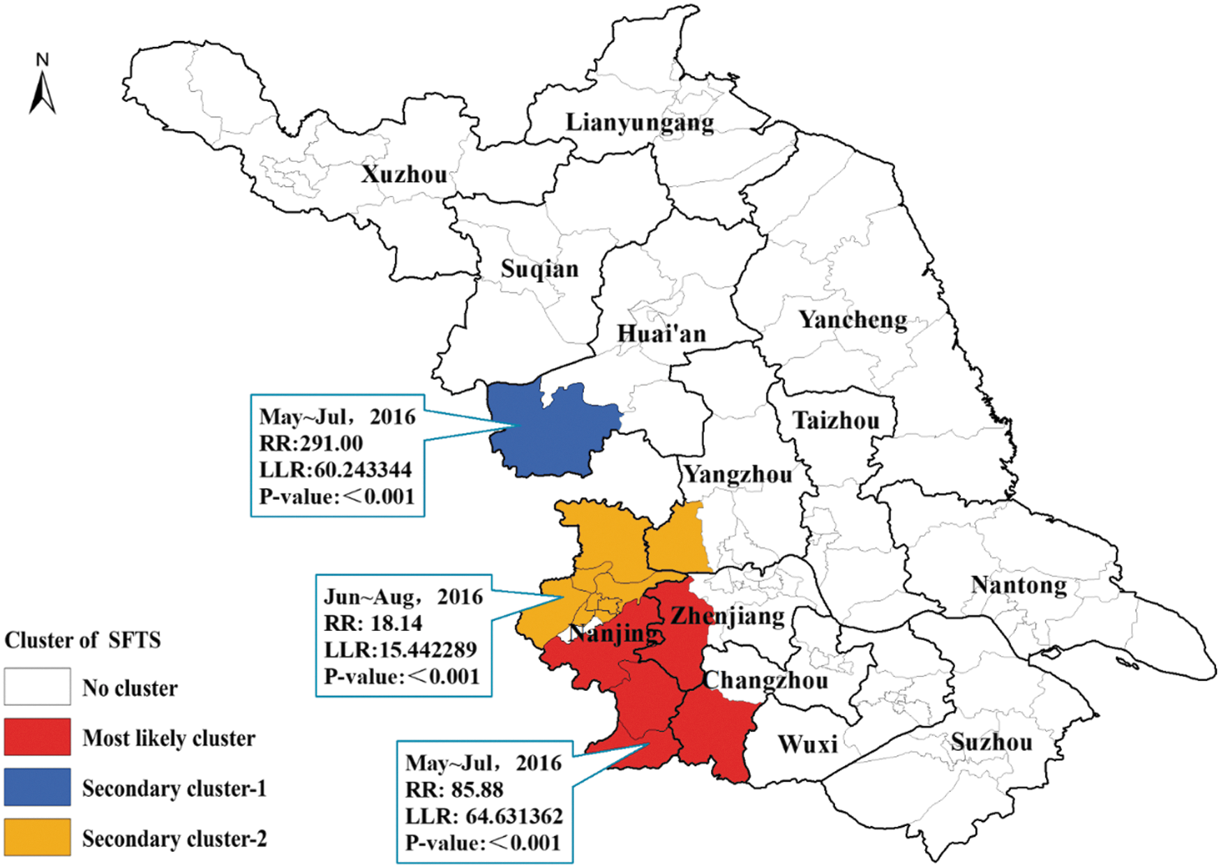
Spatiotemporal clusters of SFTS in Jiangsu Province, 2010–2016.
Environmental risk factors
Thirty-two environmental variables were obtained from online databases (Supplementary Table S1). Some highly intercorrelated (correlation coefficient >0.9 or less than −0.9) variables were removed, because they might violate statistical assumptions and alter model predictions. Finally, 17 environmental variables, including 3 climate variables, 9 bioclimatic variables, 2 surface factors, and 3 topographic factors, were selected to build the MaxEnt ecological niche model.
The relative importance of environmental variables for SFTS natural foci was measured by the percent contribution to the model. Slope and maximum temperature of warmest month (bio_05) had remarkable influences on the distribution of SFTS natural foci, respectively, contributing 46.1% and 23.2%, whereas each of the other 13 variables contributed <8%. Two variables (i.e., solar radiation and altitude) had little effect on the distribution of SFTS natural foci. The suitable ranges of slope and bio_05 for SFTS natural foci presence were 0.1–4 and 32.8–34.2°C, respectively. The suitable ranges for other factors are given in Table 1.
Relative Contributions of Environmental Variables to the Maximum Entropy Model
The suitable range of each variable indicates the conditions within which the probability of SFTS natural foci presence is higher than 50%.
None, this environmental factor had little effect on the final model construction.
SFTS, severe fever with thrombocytopenia syndrome.
The exposure–response curves indicated that the probability of SFTS natural foci presence was nonlinearly associated with the variation of each environmental variable (Fig. 4). The probability of SFTS natural foci presence sharply increased with slope value, peaked at *0.3, and decreased subsequently (Fig. 4A). The exposure–response curve of bio_05 appeared prominent inverted “U” type (Fig. 4B), in which the risk for SFTS natural foci presence initially increased, peaked at a certain value, and declined thereafter.

Response curves for slope and maximum temperature of warmest month related to SFTS natural foci presence. Red lines are mean values for the 10 MaxEnt model runs and blue bars represent ±1 SD. The exposure–response curves indicated that the probability of SFTS natural foci presence was nonlinearly associated with the variation of each environmental variable. The probability of SFTS natural foci presence sharply increased with slope value, peaked at *0.3, and decreased subsequently
Jackknife analysis was further used to assess the relative importance of each individual environmental variable to the MaxEnt model (Fig. 5). The result indicated that slope and bio_05 provided reasonably good fits to the training data, indicating they contained the most useful information that was not contained in the other variables. Although altitude (dem) provided only a little gain, omitting it decreased the training gain considerably (see the lighter blue bars), implying it was necessary for estimating the distribution of SFTS natural foci.
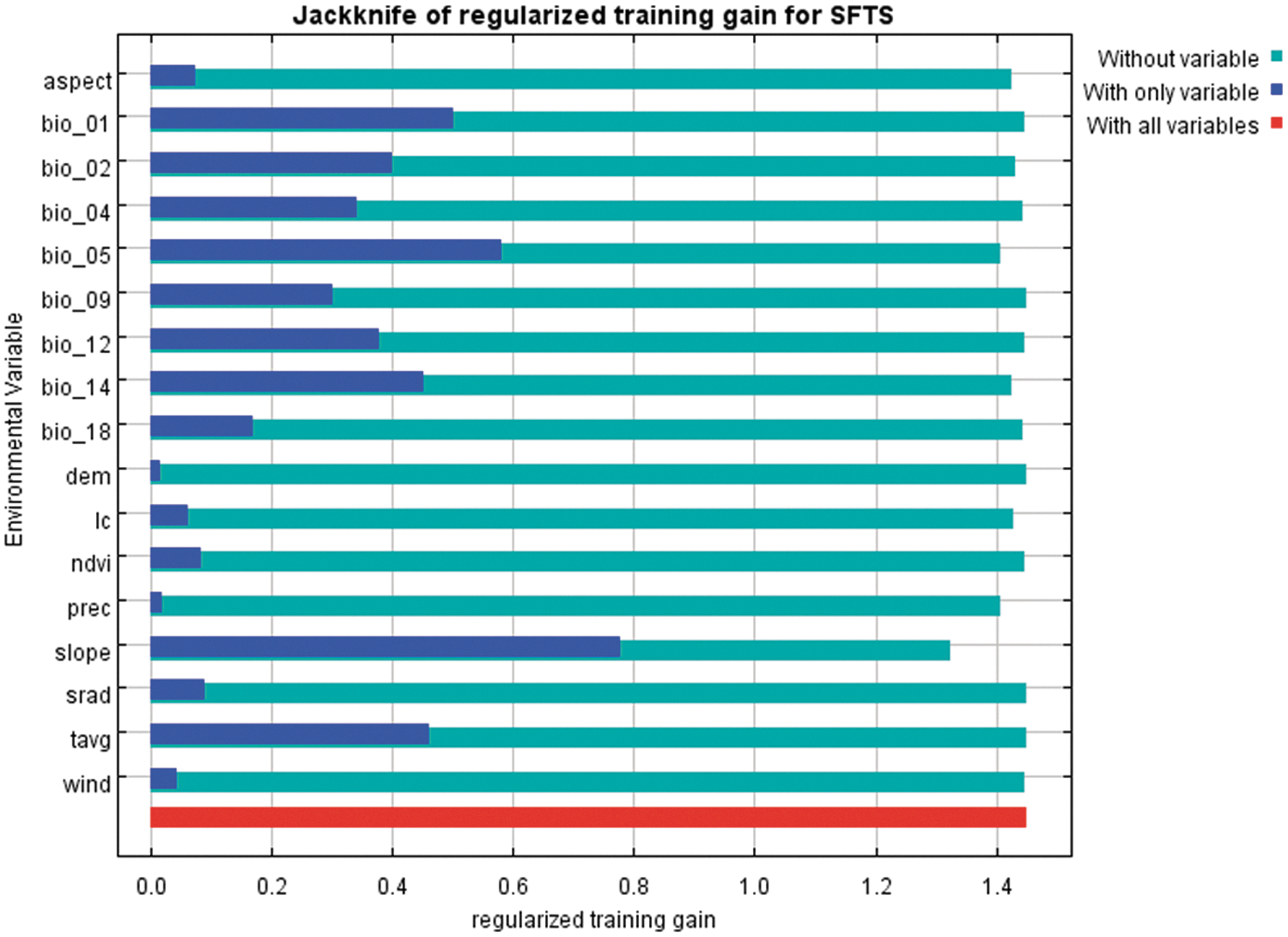
Jackknife analysis results of the training gain of environmental variables by the MaxEnt model. The blue, lighter blue, and red bar represent results of the model created with each individual variable, all the remaining variables and all variables.
Mapping the potential distribution of SFTS natural foci
The averaged training AUC and test AUC drawn from 10 replicate runs was 0.926 and 0.861, respectively, indicating the model achieved high accuracy on prediction (Supplementary Table S2).
A predicted risk map of SFTS natural foci in Jiangsu Province was obtained by ArcGIS (Fig. 6). The potential SFTS natural foci in Jiangsu Province mainly existed in the southwestern region, whereas it was rarely reported in the northern and eastern region. Potential areas at high risk for SFTS were located in southwestern cities, including Nanjing City, Yangzhou City, Huai'an City, Zhenjiang City, and Changzhou City. Within the predicted risk regions, most of them were recognized by the known SFTS natural foci. However, 10 previously unidentified endemic regions including Yizheng County, Lianyungang County, Jinhu County, Pixian County, Sheyang County, Hanjiang County, Dantu County, Jintan County, Gusu County, and Huqiu County were identified, which remained to be verified in the future.
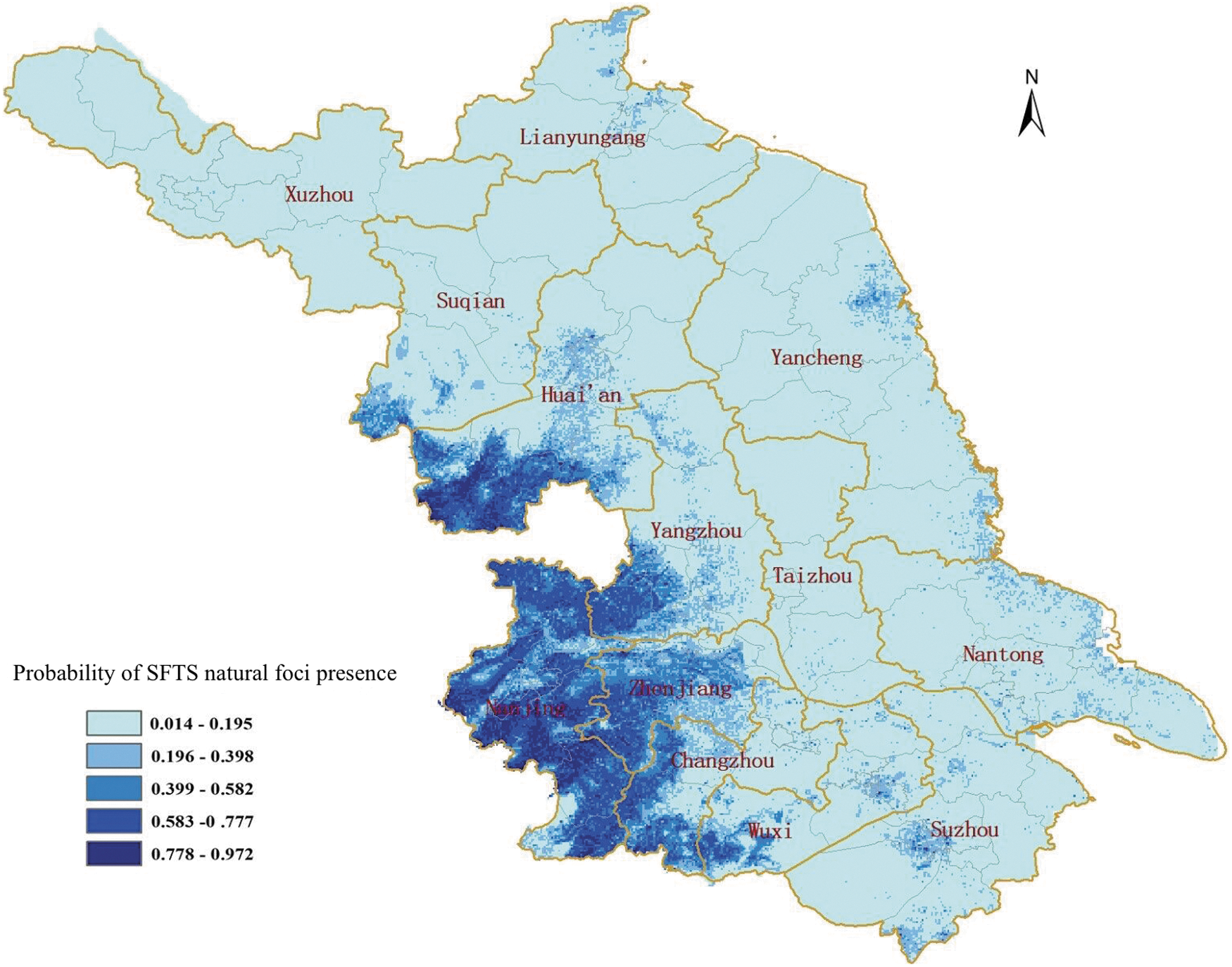
The predicted risk map of SFTS natural foci in Jiangsu Province.
Discussion
We used the MaxEnt ecologic niche modeling method and geographic information systems to analyze the geographic distribution of the SFTS natural foci and their environmental risk factors in Jiangsu Province. Ecological niche modeling was initially developed to estimate the probability distribution of a species. At present, it has been in wide use in spatial predictions of infectious diseases like plague, hemorrhagic fever, and malaria (Peterson et al. 2006, Hay et al. 2009, Holt et al. 2009). Compared with parallel prediction methods, the MaxEnt approach performs better in distinguishing the interaction among variables and shows the best predictive result with all sample sizes (Hernandez et al. 2006, Wisz et al. 2008). More important, it can be utilized based on presence-only datasets rather than absence datasets that are much harder to be obtained (Samy et al. 2014).
Based on the surveillance data of indigenous SFTS cases, we found that the reported number of indigenous SFTS cases had increased continuously over time since 2010. Two reasons could explain this phenomenon. First, it is likely to be the result of medical staff's increased awareness about SFTS and their improved diagnostic and therapeutic ability. Second, environmental changes maybe contributed to altering host diversity, abundance, dispersal, the development cycle of the pathogen, and the suitability of habitat for both tick and hosts, following by increases of the population's tick exposure (Wikel 2018).
In this study, the seasonal characteristics become more obvious with the increase of the reported number. Consistent with previous research, SFTS cases occurred from April to October with a peak between May and August (Sun et al. 2017, Wang et al. 2017). The spatiotemporal analysis showed that three clusters were detected by space–time scan statistical analysis. They are connected together and shared the similar ecological environmental characteristic of hilly landscape (Zhu et al. 2009). Although these clusters occurred during the peak period, the occurrence time of the most likely cluster and the secondary cluster 1 is different from the secondary cluster 2. It suggests that prioritized control measures should be conducted during different periods in these detected areas. Moreover, obvious seasonality and spatial heterogeneity for the occurrence of SFTS conform to the epidemiological characteristics of a natural focus disease.
A lot of environmental variables can influence the distribution of SFTS natural foci in different degrees, which indicates that the occurrence of SFTS has a specific ecological niche with multidimensional environmental factors playing roles in the disease transmission cycle. Our study showed that slope had the most significant influence on the model covering 46.1% contribution, and the suitable range of slope was <4°. It was consistent with the conclusions of previous studies that >87% SFTS patients were farmers residing in hilly regions (Liu et al. 2014, Zhan et al. 2017). Meanwhile, this might also help us to shed light on spatially clustered distribution of indigenous SFTS cases in Jiangsu Province. Moreover, our study showed nonlinearity between maximum temperature of warmest month and SFTS natural foci presence. Some studies in vector-borne diseases have suggested that temperature can significantly alter the replication and circulation of pathogens for which ticks act as vectors within an appropriate scale, the lifecycle and transmission dynamics of virus vectors, and the behaviors and ecological characteristics of both wild and native hosts (Yano et al. 1987, Gray et al. 2009, Sun et al. 2018b).
The researches about environmental risk factors and geographic distribution of SFTS are poor at present. Du et al. (2014) found that annual mean temperature, January mean precipitation, land cover, July mean temperature, and January mean temperature had remarkable influences on the distribution of SFTS natural foci, whereas each of the other 10 variables contributed <8%. It is the only published article about ecological niche modeling of SFTS. Our study and their study selected different variables, 32 and 15 variables, respectively. Slope, the key variable, was not included in their study. In addition, the multicollinearity of variables was eliminated throughout correlation analysis and my own professional knowledge in our study, but Du et al. (2014) did not take multicollinearity of variables into account.
The surveillance data of Jiangsu Province was used to predict the potential distribution of SFTS natural foci by MaxEnt ecological niche modeling. These findings suggest that potential areas at high risk for SFTS were predominantly in southwestern hilly regions. The predicted distribution of SFTS natural foci was consistent with the occurrence locations of reported SFTS cases from 2010 to 2016, which also implied that the established model had a good prediction effect. However, there are some previously unidentified endemic regions considered as not to be affected or without human cases officially reported to date, including Yizheng County, Lianyungang County, Jinhu County, Pixian County, Sheyang County, Hanjiang County, Dantu County, Jintan County, Gusu County, and Huqiu County. Therefore, the surveillance and reporting system of SFTS cases in these areas should be strengthened in the future.
One highlight of our study was that geographic distribution of SFTS natural foci in Jiangsu Province was illuminated by spatiotemporal cluster analysis and ecological niche modeling. It should be noted that the multicollinearity of variables was eliminated throughout correlation analysis and my own professional knowledge, so an ideal mathematical model was established (averaged training AUC = 0.926 and test AUC = 0.861). The other highlight was that the slope cumulatively contributed 46.1% to the model in this study, which is the first-ever demonstration of slope as the major environmental factor affecting SFTS natural foci presence. The above research results also provided a mathematical explanation as to why most SFTSV infection occurred in patients in hilly regions.
However, this study still has some limitations. As the environmental condition of China was extremely complex, it was difficult to predict a risk map of the whole country using the dataset of one province. Accordingly, we only mapped the potential distribution of SFTS natural foci in Jiangsu Province. In addition, what must be clarified is that MaxEnt modeling results only represented localities with similar conditions for the occurrence, not the actual range limits. In fact, other factors, like vector abundance, biotic variables, the distribution of potential reservoir animals, and barriers to dispersal, might narrow down the predicted SFTS distribution to the actual one.
Conclusion
This study provided a more detailed view of both the geographic distribution of SFTS natural foci in Jiangsu Province and the role of environmental risk factors for the distribution of SFTS natural foci. There was an obvious seasonality and spatial heterogeneity in the occurrence of SFTS in Jiangsu Province from 2010 to 2016, with three significant clusters detected in the southwest. The MaxEnt ecological niche model integrated with multidimensional environmental factors adequately analyzed and predicted the potential distribution of SFTS natural foci, and slope and maximum temperature of warmest month were identified as the key environmental factors. These results provide a valuable basis for the selection of prevention and control strategies, and the identification of potential risk areas.
Ethics Approval and Consent to Participate
In this study, the data of SFTS cases were extracted from online databases, and no sample of humans and animals was included. Therefore, the ethical approval and consent to participants are not necessary for the study. Meanwhile, all data were anonymous.
Footnotes
Acknowledgments
We thank Steven Phillips, from AT&T Labs-Research, Princeton University, for providing MaxEnt model. This study was partially funded by Natural Science Foundation of China (nos. 81601794 and 81703284), Jiangsu Provincial Key Medical Discipline of Epidemiology (ZDXKA2016008), Jiangsu Provincial Medical and Youth Talent (no. QNRC2016545), and Jiangsu Provincial Nature Science Foundation (no. BK20161584). The funders had no role in study design, data collection and analysis, decision to publish, or preparation of the article.
Authors' Contributions
Conceptualization: J.H. and F.Z.; data curation: D.Z.; dormal analysis: D.Z. and C.S.; funding acquisition: J.H. and Z.L.; investigation: H.Y., J.L., Z.L., D.L., and N.Z.; methodology: C.S. and W.L.; project administration: D.Z., C.S., and J.H.; resources: C.S., F.Z.; software: J.H. and W.L.; supervision: F.Z. and J.L.; validation: F.Z.; visualization: D.Z., C.S., J.H.; writing—original draft: Z.D., C.S.; writing—review and editing: J.H. and F.Z.
Author Disclosure Statement
The authors declare that they have no competing interests.
Supplementary Material
Supplementary Table S1
Supplementary Table S2
References
Supplementary Material
Please find the following supplemental material available below.
For Open Access articles published under a Creative Commons License, all supplemental material carries the same license as the article it is associated with.
For non-Open Access articles published, all supplemental material carries a non-exclusive license, and permission requests for re-use of supplemental material or any part of supplemental material shall be sent directly to the copyright owner as specified in the copyright notice associated with the article.
