
Abstract
Dengue virus serotypes 1, 2, 3, and 4 are transmitted by Aedes aegypti and Aedes albopictus mosquitoes, which cause illness in an estimated 100 million annually. Although dengue viruses are endemic throughout El Salvador, very little is known about their ecology and epidemiology. The principal methods to prevent and reduce dengue cases are through vector control and by adoption of a vaccine. In addition, understanding the environmental and socioeconomic factors associated with dengue could contribute to case reduction by targeting prevention efforts in dengue hotspots. This study investigated environmental and socioeconomic factors associated with dengue cases in El Salvador. Dengue cases were obtained from 2011 to 2013 for 262 municipalities. The mean incidence was determined for each municipality for the 3 year period. Negative binomial regression models evaluated the relationship between dengue cases and the environmental factors elevation, forest coverage, mean annual temperature, and cumulative precipitation. Twelve socioeconomic and infrastructure variables and their relationship with dengue were also investigated by using negative binomial regression. A total of 29,764 confirmed dengue cases were reported. The mean dengue incidence for 2011–2013 was 135/100,000. The highest number of dengue cases occurred in San Salvador and surrounding municipalities, as well as in two additional cities, Santa Ana and San Miguel; the highest incidence of dengue cases (per 100,000) occurred in cities in the west and at the center of the country. Significant environmental variables associated with dengue included temperature, precipitation, and non-forested area. The socioeconomic variables poverty rate, illiteracy rate, and school attendance, and the infrastructure variables percent of homes with sanitary service, municipal trash service, electricity, and cement brick flooring, as well as population density, were also significant predictors of dengue. Understanding these environmental and socioeconomic factors and their relationship with dengue will help design and implement timely prevention strategies and vector control to reduce dengue in El Salvador.
Introduction
Over the past 50 years, there has been a global reemergence of vector-borne diseases. One of these arboviruses is dengue, which is transmitted by Aedes aegypti and Aedes albopictus mosquitoes. Dengue is considered to be the most widespread arboviral disease in the world, and it causes an estimated 50–100 million illnesses annually (Gibbons and Vaughn 2002, WHO 2009), whereas the number infected with dengue is estimated to be >300 million (Bhatt et al. 2013). More than 50% of the world's population lives in dengue-endemic countries and as a result, has a high risk of infection (Gubler 2002, 2011).
Dengue is attributed to four different dengue virus serotypes (DENV-1-4) (Hasan et al. 2016). Infection with one serotype will not provide cross-protection against the other types. Creating a vaccine for the dengue virus has been challenging due to the multiple dengue serotypes (Tolle 2009). Mosquito control is one of the primary methods to reduce dengue, but vector control can have limits due to factors such as insecticide resistance. Therefore, understanding environmental and socioeconomic factors associated with the occurrence of vector-borne diseases could contribute to dengue prevention.
Environmental conditions such as climate, weather, and vegetation coverage affect the distribution and risk of many vector-borne diseases, including dengue (Bouma and van der Kaay 1996, Anyamba et al. 2001, Gubler et al. 2001, Enscore et al. 2002, Cazelles et al. 2005). Temperature influences vector development rates, behavior, and range (Christophers 1960, Tun-Lin et al. 2000, Siraj et al. 2014), as well as viral replication within the mosquito (Watts et al. 1987, McMichael and Haines 1997). A positive relationship has generally been found between temperature and dengue cases (Bhatt et al. 2013, Messina et al. 2019), whereas higher temperatures may not be optimal for mosquitoes or the virus (Colón-González et al. 2013). Precipitation variability influences habitat prevalence for Aedes larvae and pupae (Morin et al. 2013). In the tropics, dengue cases can occur year-round but they are more frequent in the rainy season than the dry season (Nakhapakorn and Tripathi 2005, Pham et al. 2011, Colón-González et al. 2013). The abundance of Aedes larvae can also relate to incidence of dengue (Hayes et al. 2003). Other factors related to dengue cases are vegetation and forest coverage, in particular deforestation and urbanization (Nakhapakorn and Tripathi 2005, Van Benthem et al. 2005, Troyo et al. 2009, Pham et al. 2011, Swain et al. 2019).
Socioeconomic factors such as income, education, and urban conditions can additionally contribute to dengue incidence. Known risk factors for dengue include income levels (Brunkard et al. 2004), education levels (Spiegel et al. 2007), and population density (Dickin et al. 2013, Swain et al. 2019). Poor garbage disposal or waste collection has been associated with dengue (Mourya et al. 2004, Thammapalo et al. 2008), as are homes that contained discarded containers or tire casings (Hayes et al. 2003). The incidence of dengue can increase due to peri-domestic water storage but has also been shown to increase when there is piped water (Colón-González et al. 2013), suggesting that the association with water storage may be complex. The absence of air conditioning and street drainage are also potential risk factors (Brunkard et al. 2007).
In Central America, four to five million people annually are estimated to be infected with dengue (Hotez et al. 2014). Factors associated with dengue in Central America have been investigated (Troyo et al. 2009, San Martín et al. 2010, Zambrano et al. 2019), yet there are a few studies of dengue in El Salvador (Hayes et al. 2003). El Salvador is a country of ∼6 million and one of the most densely populated and deforested countries in the Western Hemisphere (PAHO 2017, World Bank 2019). Dengue continues to be a persistent public health threat. The country has a tropical climate (Armentera et al. 2016), which is ideal for the dengue vectors Ae. aegypti and Ae. albopictus.
An eradication campaign for Ae. aegypti in the Western Hemisphere in the 1950s and 1960s eliminated this mosquito from El Salvador (Soper 1967, Gubler and Trent 1993, Hayes et al. 2003). Unfortunately, Ae. aegypti was reintroduced and outbreaks of dengue have been occurring since 1980 (Gubler and Trent 1993), and the mosquito is now widespread in El Salvador (Joyce et al. 2018). During a dengue epidemic in 2000 in El Salvador, a study of risk factors at the household level found that most participants were aware that mosquitoes transmitted dengue, yet 36% of homes had mosquito larvae (Hayes et al. 2003). There is currently no systematic surveillance of vector-borne disease or mosquitoes such as Ae. aegypti in El Salvador (MINSAL 2014, Joyce et al. 2018). In addition, Chikunguya virus and Zika, which are also transmitted by Ae. aegypti, have been reported since 2014 and 2015 in El Salvador, respectively (Wilson and Chen 2002, Higgs and Vanlandingham 2015, Shutt et al. 2017).
This study is the first to evaluate multiple variables and their association with dengue cases at the municipality (county) level throughout the country of El Salvador. The objective of this study was to determine which environmental and socioeconomic factors were associated with dengue in the years 2011–2013, before the introduction of Chikungunya and Zika viruses. We hypothesize that temperature, precipitation, and non-forested area are associated with dengue cases, and socioeconomic variables such as education, housing infrastructure, and population density may be significant predictors of dengue as well. Understanding these factors could contribute to focusing efforts to reduce dengue incidence in El Salvador.
Methods
Description of the study area
El Salvador is located in Central America within the Pacific slope (13°47′39.1″ N, 88°53′47.5″ W). The country has a territorial extension of 20,415 km2 with an approximate population of 6.4 million (World Bank 2019); it is divided into 14 departments and 262 municipalities (Fig. 1, Supplementary Table S1). The climate of El Salvador is tropical, and the dry season extends from November to April whereas the rainy season lasts from May to October (Armenteras et al. 2016). In El Salvador, similar to other countries of Central America, extreme maximum temperatures are increasing, with high temperatures being more pronounced in the dry season (Aguilar et al. 2005, Quesada-Hernández et al. 2019). El Salvador is frequently influenced by tropical hurricanes and is highly vulnerable to floods and droughts (Aguilar et al. 2009).
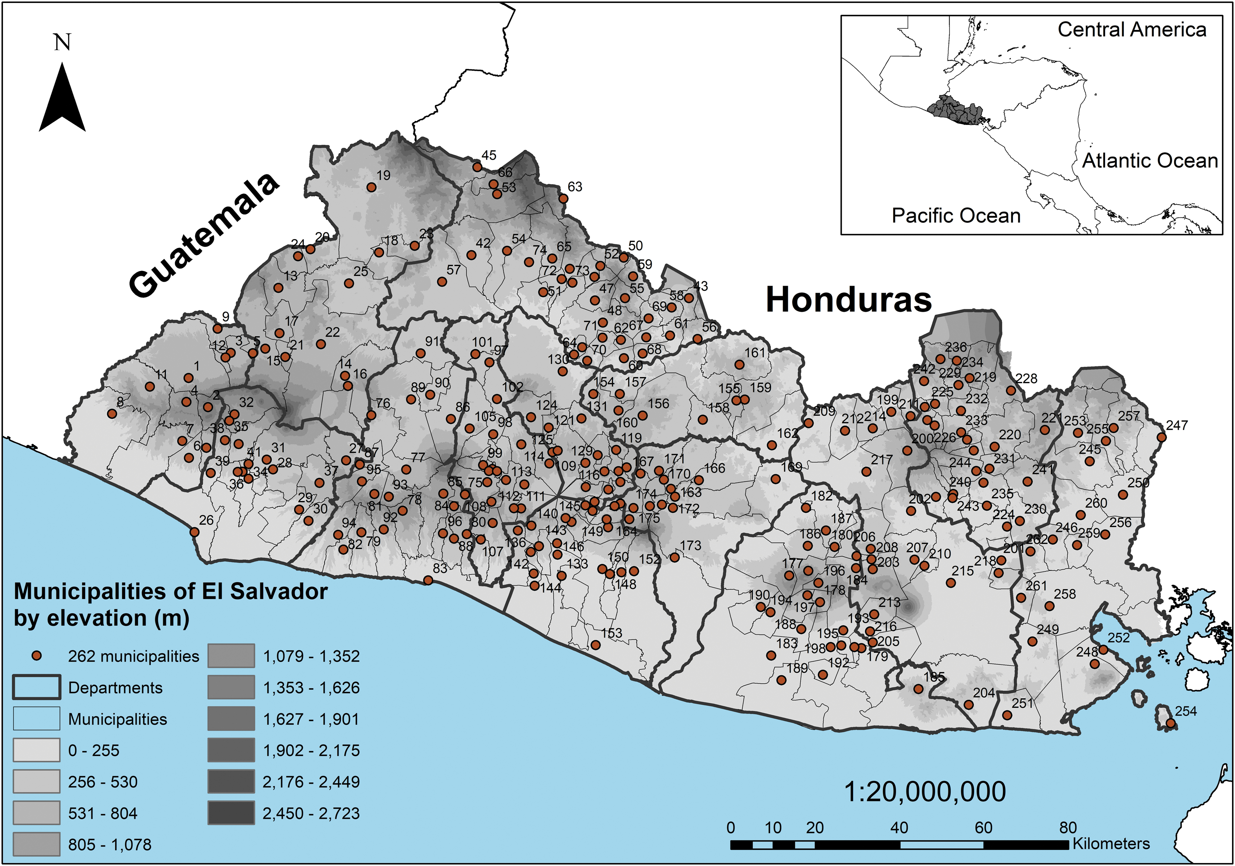
Map of 262 municipalities in El Salvador, shaded by elevation (m). Darker shading indicates higher elevation. The number in each municipality corresponds to its name, listed in Supplementary Table S1.
Much of the primary forests have been deforested by agriculture and livestock and almost all ecosystems are categorized as threatened or endangered according to International Union for Conservation of Nature criteria (Crespin and Simonetti 2015, 2016). The country currently has a forest coverage of ∼37% remaining throughout the country (mainly secondary forests and forest plantations) and much of the territory is dominated by urban areas, agriculture, and livestock (MARN 2018). It is estimated that in El Salvador, 71% of the population is urban and 29% is rural, and the poverty rate is 29% (World Bank 2019). The health care system is composed of 30 public National Hospitals and nearly 600 additional community health units distributed throughout the country (DIGESTYC 2007).
Dengue cases
Confirmed dengue cases were obtained from 262 municipalities in El Salvador. The data were available as total confirmed dengue cases per year (2011–2013) for each municipality, from the Ministry of Health of El Salvador. There was no distinction made of whether a case was Dengue 1, 2, 3 or 4. Data for subsequent years (after 2013) were not included in the present study since Chikungunya was reported since 2014 and Zika since 2015. Confirmed dengue cases are reported to the national surveillance system from the diagnoses of patients who expressed acute febrile illness (fever over 40°C) and two or more of the following symptoms (headache, retro-orbital pain, myalgia, arthralgia, rash, hemorrhagic manifestations, or leukopenia) (WHO 2020), as well as by lab confirmation of a positive ELISA test for IgM dengue antibodies (MINSAL 2010). The confirmed dengue cases for each municipality for 2011–2013 were used to calculate the mean cases per year (2011–2013), the incidence per 100,000 for each municipality for 2011, 2012, and 2013, and the mean incidence for 2011–2013 combined.
Socioeconomic variables
The demographic and socioeconomic variables were obtained from each of the 262 municipalities from the 2007 census of the Statistics and Census Bureau of El Salvador (DIGESTYC 2007), whereas poverty rate per municipality was obtained from the Fondo de Inversion Social para El Desarrollo Local (FISDL 2005). A total of 12 socioeconomic variables for each municipality were included in analyses (Table 1). Socioeconomic variables included poverty rate, illiteracy rate, and school attendance; yearly household income was not a variable in the census data, so poverty rate was obtained from FISDL. Infrastructure variables included percent of households using electricity for lighting, percent of homes with sanitation service (plumbing), percent of homes with municipal garbage service, and percent with potable water. Four additional variables included were materials used for household flooring; materials included cement foundation, cement brick, ceramic tiles, and earthen floors. Population density was used as a control variable in all models. These variables were used in the statistical analyses described next.
El Salvador Census Variables at the Municipality (County) Level
Poverty rate variable comes from
Environmental and climate variables
The precipitation and temperature data were obtained from databases of the Ministry of Environment and Natural Resources of El Salvador (MARN). The data come from 24 meteorological stations distributed throughout the country. Daily temperatures were reported and were used to calculate the means for the minimum, maximum, and mean temperature (°C) for each municipality for 2011, 2012, and 2013, and for 2011–2013 combined. Daily precipitation values were used to determine the cumulative total precipitation (mm) for each year, and for the 3 years (2011–2013) combined. For each municipality, the temperature and precipitation values were assigned from the meteorological station that was closest in distance and most similar in elevation. To assign a meteorological station to a municipality, the geographic coordinates were found for the 262 municipalities (county seats) and also for the 24 meteorological stations, and they were used to calculate distances between each municipality and nearby weather stations. If two stations were equal distance to a municipality, the station with a more similar elevation was assigned.
The environmental variable of percent forest cover per municipality was estimated using data available for El Salvador, which comes from high-resolution global maps (Hansen et al. 2013). Images have a resolution of 30 m2 and coverage of forest canopy ≥25% with trees more than 5 meters high. Using these data, percent area with forest coverage and percent area non-forested (one-forested area) were determined for each municipality. A significant negative relationship has previously been reported between forest cover and dengue (Husnina et al. 2019), so we used non-forested area as a variable. Finally, there is no systematic surveillance of vector-borne disease, or collection of mosquitoes in El Salvador, so these variables could not be included in this analysis. Occasionally in El Salvador, there are household mosquito larval indices calculated, but there is no country-wide mosquito surveillance (MINSAL 2014). Geographic and spatial data were processed using Geographic Information System ArcGIS 10.3 software.
Statistical analysis
Descriptive data were first produced to examine the total number of confirmed dengue cases per year, mean cases per year for 2011–2013, dengue incidence per 100,000 people per year for each municipality, and mean dengue incidence country wide per year (2011–2013). Dengue incidence per year was calculated as dengue cases divided by the total population of the municipality, multiplied by 100,000 (Supplementary Table S2). Subsequently, negative binomial regression models were run to examine the relationship between environmental variables and dengue cases, as well as between socioeconomic variables and dengue cases.
The environmental variables elevation, nonforested area, total annual precipitation 2011–2013, and mean annual temperature for 2011–2013 were included as variables in a negative binomial regression. For socioeconomic variables, several negative binomial models were run. The first model considered the factors of poverty rate, illiteracy, and school attendance. The second model included four infrastructure variables, which were municipal trash service, sanitary service, electricity for lighting, and potable water. A third negative binomial regression model was run to examine whether any of the four household flooring materials (cement foundation, cement brick, ceramic tile, or earth floor) were predictors of dengue cases. All variables were used for each municipality (county level) for the 262 municipalities in the country.
Negative binomial regression is used when the dependent variable is a count variable with a Poisson-like distribution. A negative binomial regression is used rather than Poisson when the data are considered overdispersed. Before running each model, the multicollinearity of the variables in each model was assessed with the variation inflation factor statistic; all variables included in models had values <3. All analyses were performed using the software STATA 15.1. The population density (total population/area in municipality) for each municipality was included as a control variable in all models. For all models, the incidence ratios (IRR) were determined. The IRR estimates the rate of change in the dependent variable associated with each unit increase or decrease in the independent variable in the model. Variables with p values <0.05 were considered significant.
Results
Incidence of dengue in municipalities
The total number of confirmed dengue cases per year (2011–2013) ranged from 4668 in 2011 to a high of 13,689 cases in 2012, with a total of 29,764 confirmed cases. The mean incidence of dengue cases per 100,000 per year (2011–2013) was mapped for each municipality (Fig. 2); the overall mean incidence per year for El Salvador (2011–2013) was 135.40/100,00.
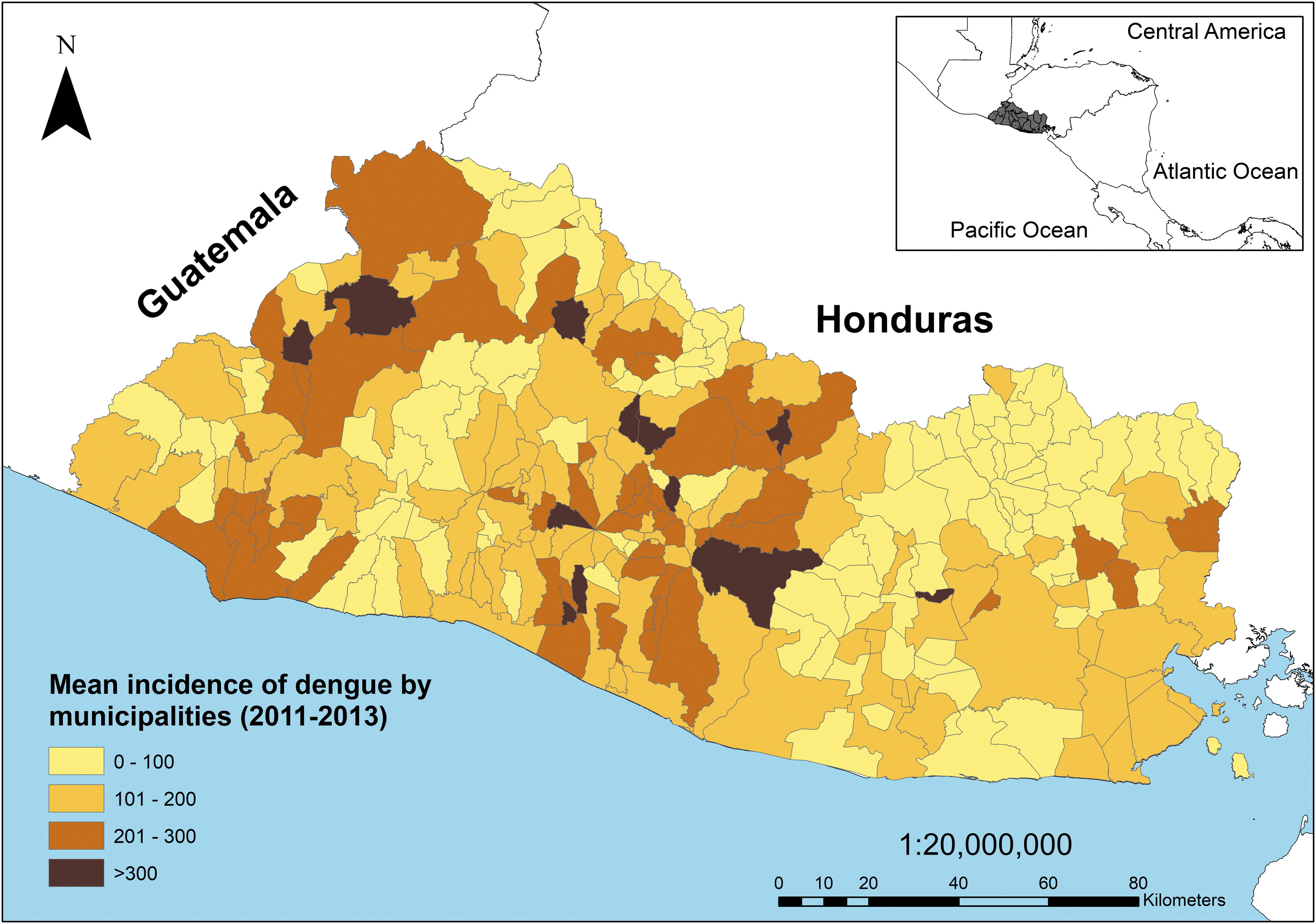
Mean yearly incidence per 100,000 of dengue cases in El Salvador (2011–2013).
The 10 municipalities with the highest cumulative number of cases from 2011 to 2013 and their respective incidence rates (2011–2013) came from the highly urbanized municipalities of Santa Ana (Department [Dept]: Santa Ana) (2117 cases; 287.53/100,000), San Salvador (Dept: San Salvador) (1888 cases; incidence 199/100,000) and its suburbs, and from San Miguel (Dept: San Miguel) (2523; 187/100,000) (Table 2, Supplementary Table S2). The municipalities with the 10 highest incidence rates ranged from 300 to 600/100,000; 8 of the 10 municipalities had <10,000 inhabitants, with one exception being Ilopango, San Salvador (Fig. 2, Supplementary Table S2).
Ten Municipalities with the Highest Mean Number of Dengue Cases per Year (2011–2013), Their Associated Population, and Dengue Incidence Rate per 100,000
Municipalities with the lowest number of cases were primarily in the departments of Chalatenango and Morazán, mountainous departments that border Honduras, and included San Isidro Labrador, San Antonio de La Cruz, Potonico, San Francisco Lempa, Ojo de Agua, Las Flores (all Chalatenango), Arambola, Torola, and Perquín (Morazán, all 0–2 cases) (Supplementary Table S2).
Socioeconomic variables
The mean and range were determined for the socioeconomic variables included in the analyses. The mean percent illiteracy in the 262 municipalities was 16% (range 4–46%), school attendance was 85.3% (63.4–96.2%), and poverty rate was 52.02% (10.6–88.5%). For all municipalities, there was an average of 69.2% of households with potable water (3.0–99%), 88.6% of households had indoor plumbing (42–95%), 82.1% of households had electricity for lighting (30–99%), and 50% (0–96%) had municipal garbage service. Home flooring construction consisted of 18.12% with cement foundations, 36.6% with cement brick flooring, 6.7% with ceramic tiles, and 18.9% with earth floors.
Climatic variables
The minimum, mean, and maximum temperatures for each year (2011–2013) and for the 3 years combined were determined for each municipality (Table 3). The average maximum temperatures varied from 21°C to 36°C (mountainous and coastal regions), the mean temperature ranged from 17 to 29°C, and the minimum temperatures averaged from 12°C to 24°C (Table 3, Fig. 3). The annual mean cumulative precipitation 2011–2013 ranged between 1482 and 2855 mm (Fig. 4). The greatest forest cover predominates in the volcanic zones (Central Graben region), and at high elevation in large mountain ranges in the central and northern part of the country, near Guatemala and Honduras (Figs. 1 and 5). The non-forested areas are located from ∼0–800 meters in elevation, and they coincide with urban areas having higher population densities such as Santa Ana, San Salvador, and San Miguel (Figs. 1 and 5).
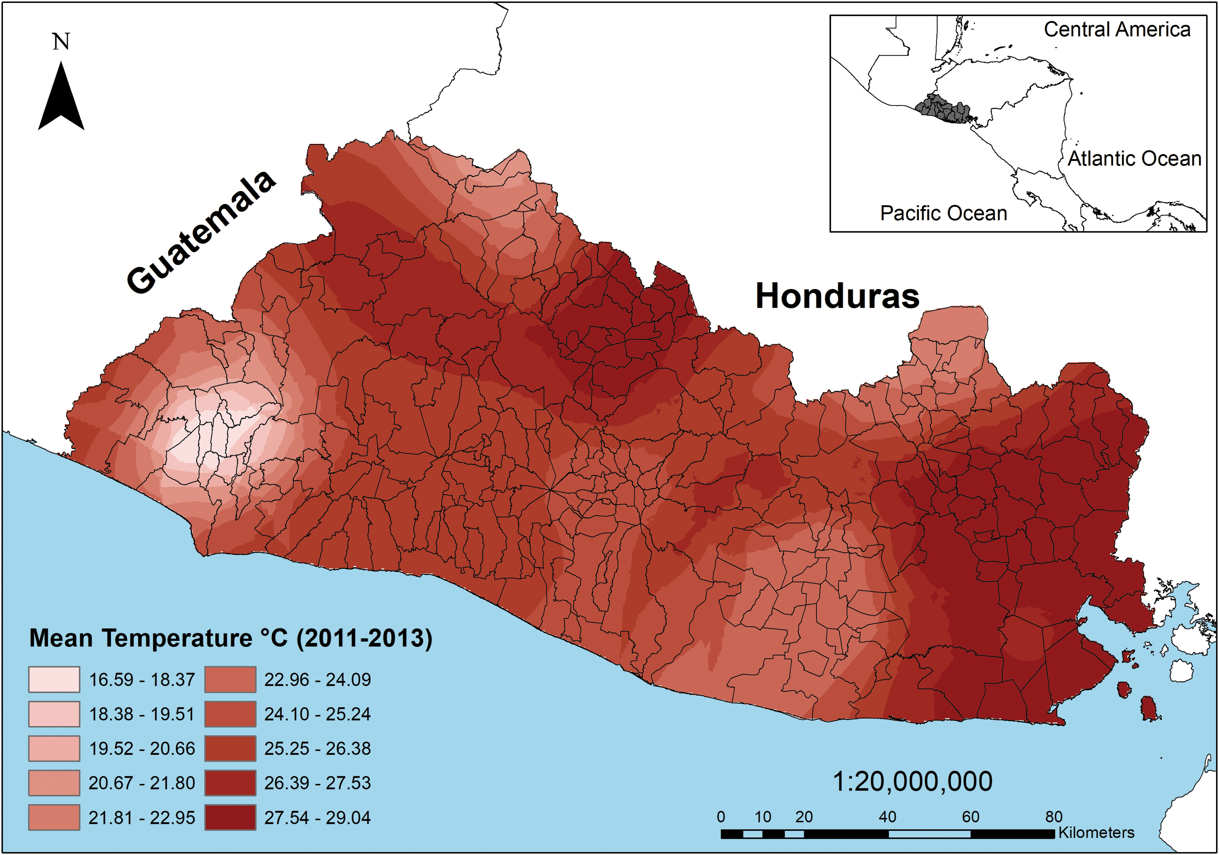
The mean annual temperature (2011–2013) for each municipality of El Salvador.
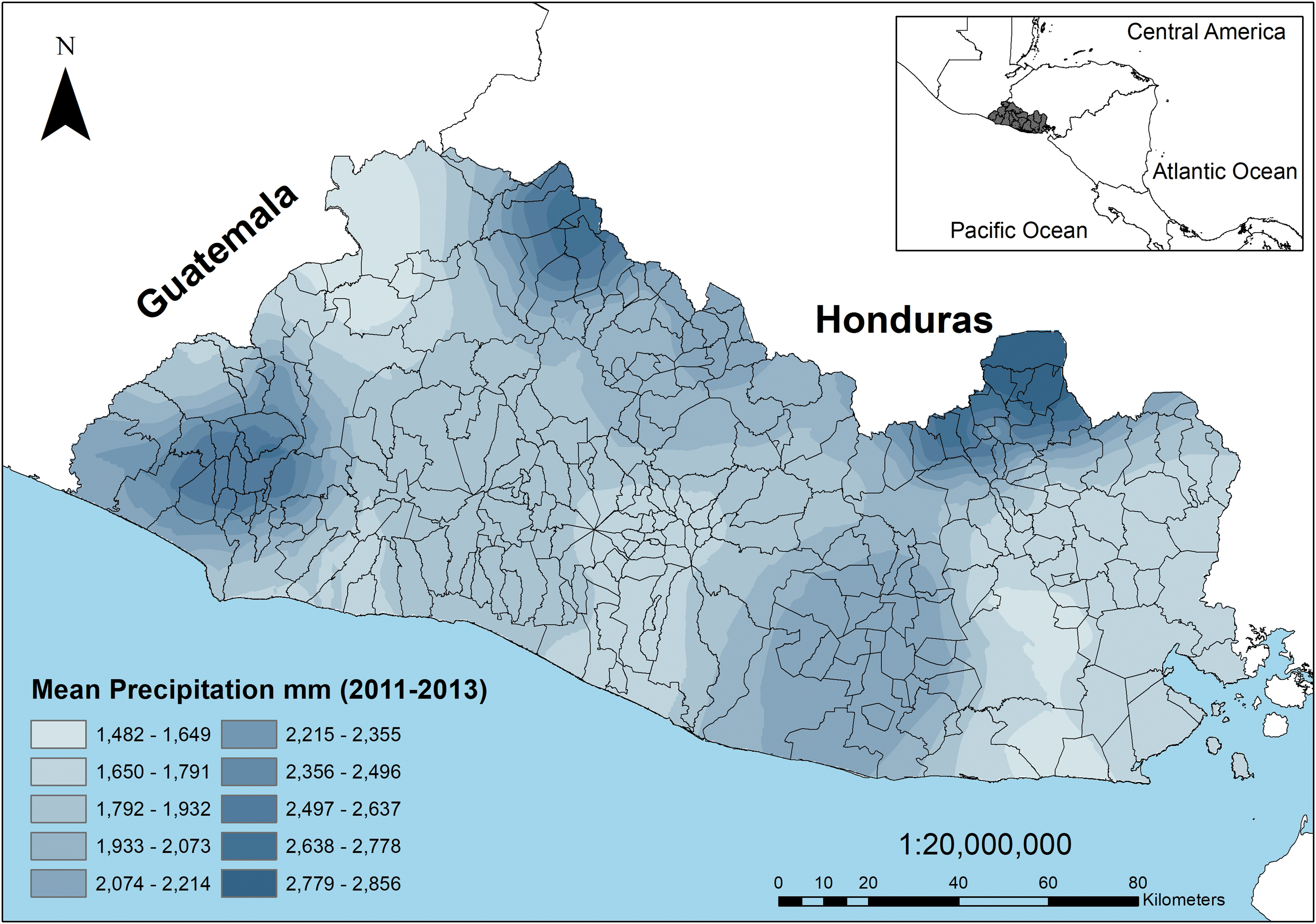
The mean cumulative precipitation for 2011–2013 for each municipality in El Salvador.

The area with forest coverage for each municipality in El Salvador.
Minimum, Mean, and Maximum Daily Temperature (°C), the Total Precipitation per Year (mm), and Confirmed Dengue Cases for Each Year, 2011–2013
Data are from 24 meteorological stations. Dengue cases come from 262 municipalities.
Negative binomial regressions
The model with environmental variables was significant (X2 5 = 101.26, p < 0.001), and a positive relationship was found between dengue cases and non-forested area (Table 4). For each percent increase in non-forested area, there was a 46% increase in the relative risk of dengue. There was a significant relationship for precipitation and temperature as well (Table 4). The cumulative precipitation was related to a very modest decrease in dengue cases (<1%). Municipalities with higher cumulative precipitation had lower risk of dengue, as did municipalities with higher mean temperatures (Figs. 2–4). For each 1°C increase in the mean annual temperature, the relative risk of dengue cases decreased by 14%. Elevation was not significant in the model (p < 0.05).
Negative Binomial Regression for Environmental Variables Associated with Dengue Cases, 2011–2013 (X2 5 = 101.26, p < 0.001, n = 262)
Three years (2011–2013) mean annual temperature (°C) and cumulative annual precipitation (mm).
CI, confidence interval; IRR, incidence ratios; SE, standard error.
The negative binomial regression for the socioeconomic variables poverty, illiteracy, and school attendance on dengue cases was significant (X2 3 = 214.56, p < 0.001) and all three variables were significant predictors (p < 0.05) (Table 5). There was a negative relationship of dengue cases with poverty, illiteracy, and school attendance, and with each percent increase in each variable there was ∼a 5% decrease in risk of dengue (Table 5).
Negative Binomial Regression for Socioeconomic Variables Associated with Dengue Cases, 2011–2013 (X2 3 = 214.56, p < 0.001, n = 262)
A second negative binomial regression for infrastructure variables on dengue cases was also significant (X2 4 = 190.11, p < 0.001); there was a positive relationship of dengue with potable water, sanitary service, and municipal waste service (p < 0.001) (Table 6). For each percent increase in sanitary service, there was a 3% increase in relative risk of dengue. Although potable water was a significant predictor, the associated incidence rate ratio for potable water was negligible and <1%. Finally, the percent of homes with municipal trash service was highly related to dengue cases, and those with trash service had 8 times the rate of dengue compared with those without it. Materials used for home flooring were significantly related to dengue as well (X2 4 = 122.17, p < 0.001) (Table 7); homes with cement brick floors were the strongest predictor (p < 0.05).
Negative Binomial Regression for Infrastructure Variables Associated with Dengue Cases 2011–2013 (X2 4 = 190.11, p < 0.001, n = 262)
Negative Binomial Regression for Home Flooring Materials Associated with Dengue Cases, 2011–2013 (X2 4 = 122.17, p < 0.001, n = 262)
Discussion
This study investigated the relationship between environmental and socioeconomic factors and dengue cases from 2011 to 2013 in El Salvador, Central America. El Salvador is a densely populated developing country with a tropical climate and pronounced rainy and dry seasons. There were more than 29,000 dengue cases during the 3-year period, with an average yearly incidence rate of 135.40/100,000 inhabitants. Models to investigate factors associated with dengue cases found that the environmental factors temperature, precipitation, and non-forested area were significant. The socioeconomic factors illiteracy, poverty rate, school attendance, and infrastructure variables municipal trash service, sanitary service, potable water, and cement brick flooring, along with population density were all significant risk factors for dengue as well.
The mean incidence rate of dengue in El Salvador was similar to the incidence previously reported in El Salvador and in adjoining Honduras.. A previous study of El Salvador found that the city Aguilares, located ∼40 km from the capital San Salvador, had an incidence rate of 180/100,000 near the peak of an epidemic (Hayes et al. 2003). In neighboring Honduras, a dengue incidence was reported of 479/100,000 in 2016–2019 in Cortez, a densely populated department (Zambrano et al. 2019). In the current study, the highest number of mean cases (2011–2013) were found in densely populated municipalities in the urban capital San Salvador and its surrounding municipalities Soyapongo, Santa Tecla, San Martín, and Ilopango, and in the larger cities of Santa Ana and San Miguel. The mean incidence per year (2011–2013) in these municipalities ranged from 195 to 287/100,000. The 10 municipalities with the highest yearly incidence rates ranged from 300 to 600 cases/100,000 people and were in the west and center of the country. One municipality among those with both the highest mean cases per year and the highest incidence rates was Ilopongo, San Salvador (380/100,000).
The present study of El Salvador found that there was a relationship of dengue with poverty, illiteracy, and school attendance. In Thailand, higher education was related to an increased risk of dengue, as the more educated population traveled to urban cities to work (Koyadun et al. 2012); similarly, the same study found that higher income earners were more likely to have dengue. In El Salvador, school attendance was related to a decreased risk. It is possible that education increases awareness that mosquitoes transmit dengue, as found by Hayes et al. (2003). In El Salvador, the census defined illiteracy as the inability to read a paragraph. As illiteracy increased, dengue risk decreased. Lower education levels occur in rural areas, as do higher rates of poverty, and both were related to a slight decrease in the relative decreased risk of dengue in El Salvador.
Urban areas with high population densities are the ideal environment for the transmission of dengue, which occurs through a human–mosquito transmission cycle (Gubler 2011). Built area and urbanization have a significant relationship with dengue cases in numerous locations, including Thailand, Honduras, Mexico, and India (Nakhapakorn and Tripathi 2005, Zambrano et al. 2012, Colón-González et al. 2013, Swain et al. 2019). In El Salvador, there was a positive relationship between the infrastructure variables, sanitary service, municipal trash service, potable water, and cement brick flooring in homes and dengue. Some studies find that water storage in rural areas relates to increased dengue, whereas others note that in cities with running water, occasional water stoppages can also lead to water storage and increased dengue (Colón-González et al. 2013).
In the present study, potable water was a significant but marginal predictor of dengue. This may be because water storage in barrels and cisterns is common in both urban and rural areas of El Salvador, whether or not there is running water in homes. Families store water for convenience in rural areas, whereas in cities the storage of water is common to ensure availability during occasional stoppages in water delivery. Households with sanitary service (toilets and latrines) were a significant predictor of dengue cases as well. These water sources provide potential above and below ground sites for mosquito breeding. The presence of septic systems has been noted to relate to mosquito breeding, including for Aedes mosquitoes that vector dengue (DaSilva and Machado 2018).
At the municipality level, trash service was a strong predictor of dengue risk. Urban households can have different waste streams than rural households, such as ceramics and plastics, which collect water and serve as mosquito larval habitats (Banerjee et al. 2015). In Brazil, a study found that some cities with the highest relative levels of sanitation service, municipal trash service and water supply, were among those with the highest dengue fever incidence (DaSilva and Machado 2018). The relationship of municipal trash service with dengue further supports that urban populations are more susceptible to dengue.
When examining environmental variables, a positive relationship was found between dengue cases and non-forested area. Deforestation is widespread in El Salvador, with an estimated ∼37% of land having forest cover (MARN 2018). Other studies report a relationship between numbers of dengue cases and forest cover, which can be measured directly or indirectly through vegetation indices (Araujo et al. 2015, Martinez-Bello et al. 2017, Husnina et al. 2019, Swain et al. 2019). In Thailand, residences further from natural vegetation had a higher risk of dengue seroprevalence (Troyo et al. 2009). Unforested urban areas generate heat islands, characterized by high temperatures and limited vegetation, and these areas promote the transmission of dengue (Araujo et al. 2015). In El Salvador, the decrease in forest cover is associated with large extensions of urban areas. The relationship identified in this study between dengue cases and non-forested areas may be due to the fact that much of the environment of El Salvador is highly anthropogenized.
Climatic variables, including temperature and precipitation, are important predictive variables of dengue. Tropical regions such as Central America have pronounced rainy and dry seasons. Cumulative annual precipitation in tropical areas can vary; in this study, El Salvador reported mean cumulative precipitation between 1400 and 2800 mm. In neighboring Honduras, higher numbers of dengue cases were reported in the rainy season than the dry season (Zambrano et al. 2012, 2019), and a similar trend is reported in other countries with tropical climates (Pham et al. 2011, Colón-González et al. 2013). The present study in El Salvador was limited to the availability of government date, which is provided at the yearly (not weekly) level.
It is likely that a similar pattern occurs with more dengue cases during the rainy season than the dry season (CDC 1983, MINSAL 2014). For precipitation, a modest decrease is observed in the cases (<1%) with each mm of additional rainfall. The highest levels of cumulative annual precipitation fall in more forested regions at high elevation, areas that are less populated, which may explain the slight decrease in cases with precipitation (Figs. 2 and 3). Overall, the climate of El Salvador is tropical with both temperature and precipitation being highly suitable for mosquito development.
Temperature was a significant predictor of dengue cases, although the relationship was negative between cases and increasing temperature. The relationship of temperature and dengue cases has been found to be either positive or negative (Pham et al. 2011, Swain et al. 2019), and at times no relationship has been found between the two (Zambrano et al. 2019). The variation in the relationship of temperature and dengue cases in El Salvador may relate to the scale of the study. For example, a study in Thailand (Nakhapakorn and Tripathi 2005) reported an annual mean monthly temperature of 26°C, and temperature was a negative predictor of cases; however, a mean monthly temperature of 42°C was reported in April, followed by cooler temperatures in the rainy season, when more dengue cases occur. A similar pattern was shown by Swain et al. (2019).
The present study of El Salvador is limited in that dengue cases are available at the yearly level for each municipality, rather than at a weekly or monthly level. Mean monthly temperatures in El Salvador follow the pattern described for other tropical countries; temperatures are higher at the beginning of the rainy season (April) and then decline during the rainy season (Fig. 6). El Salvador's largest cities (most populated municipalities) and the cities with the highest dengue incidence are for the most part not in the eastern part of the country, where much higher temperatures occur (Figs. 2 and 4).
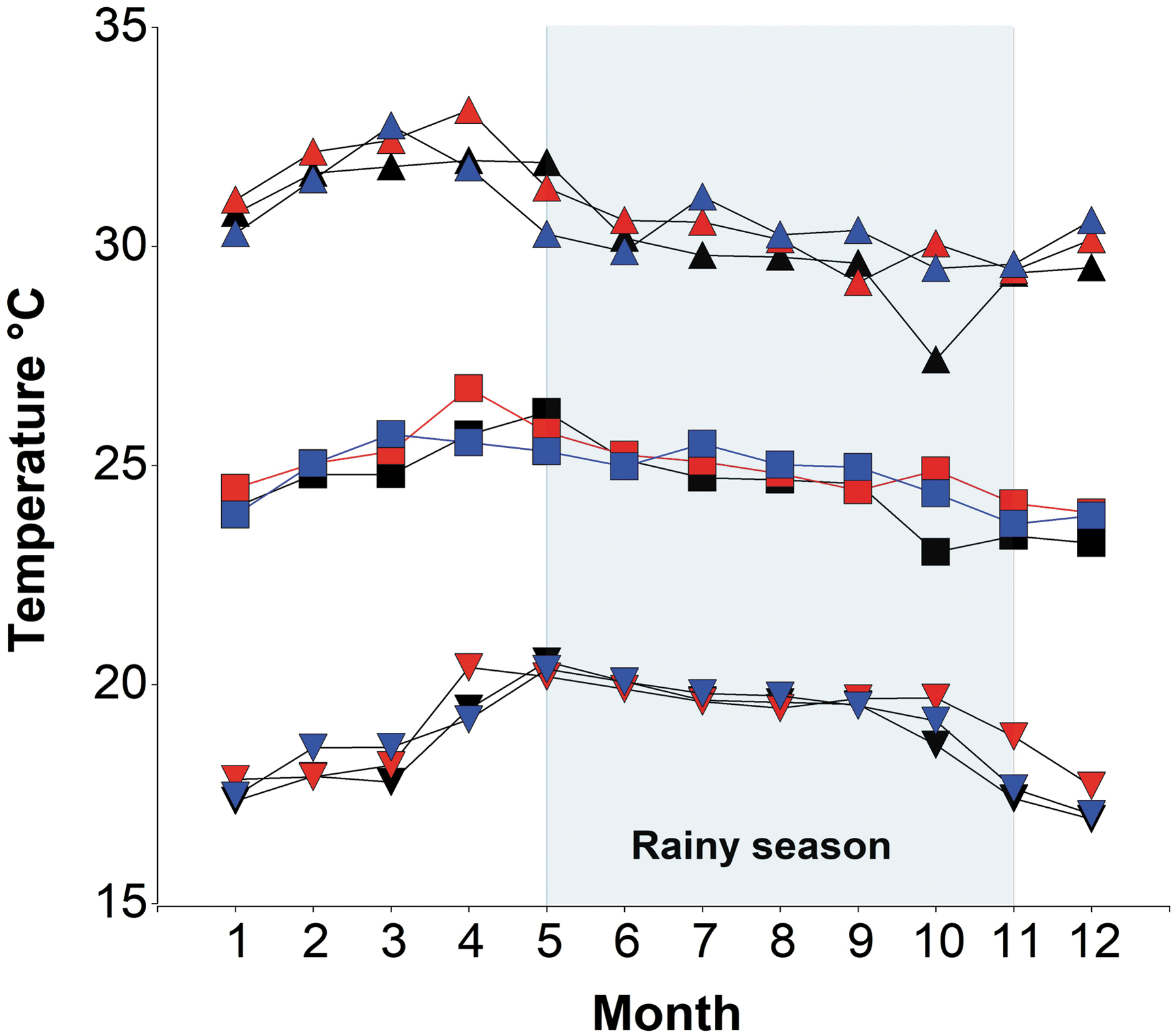
The mean monthly temperature for 2011–2013. The square represents the mean temperature, triangles are the mean maximum temperature, and inverted triangles indicate the mean minimum temperature. Black represents 2011 data, blue indicates 2012 data, and red indicates 2013 data.
This study is one of the first to describe dengue cases throughout the country of El Salvador. The objective herein was to describe the distribution of dengue cases before the first outbreak of Chikungunya and Zika viruses in 2014 and 2015 in El Salvador. We report a pattern of the highest number of dengue cases primarily in the capital San Salvador and its surrounding municipalities, as well as in two large cities in the west and east of the country, Santa Ana and San Miguel respectively. Other cities with the highest incidence occur in the western and central part of the country. The incidence of dengue cases is on the level of other epidemiological outbreaks. The distribution of reported confirmed cases is not likely a representation of where hospitals or clinics occur in the country, as clinics are widespread and dengue cases are reported countrywide, including in the smallest villages. The primary mosquito vector Ae. aegypti that transmits dengue is anthropogenic, and highly urbanized conditions promote the propagation of the insect, leading to exponential transmission of dengue in populated areas.
There are several limitations to this study. One limit is that dengue cases were available at the yearly level, so we were not able to report the peak week or month of dengue cases for 2011 to 2013, and dengue cases could not be directly related to fluctuating monthly temperatures that occur throughout the year. In addition, at this time, there is no surveillance for vector-borne illness in mosquitoes, or a systematic system for monitoring mosquito abundance on a national level, so these data could not be included in this study. Studies of dengue have examined the factors associated with cases at the local, state, country, and even regional or global levels.
Future analysis of dengue cases in El Salvador might benefit from a fine-scaled examination of cases in the municipalities with the highest incidence, as well as in the three large metropolitan areas of San Salvador, Santa Ana, and San Miguel, which had high number of dengue cases. In addition, a national system for monitoring vector-borne disease could contribute to dengue prevention and reduction of cases, by helping to focus health promotion and vector control in areas with the highest dengue incidence. The tropical climate of El Salvador and high population density make it a region where dengue prevention will remain a pressing issue.
Footnotes
Authors' Contributions
Conceptualization: A.L.J., F.S.A., and E.H.; data curation: A.L.J., F.S.A.; formal analysis: A.L.J., F.S.A., and E.H.; investigation: A.L.J., F.S.A., and E.H.; methodology: A.L.J, F.S.A., and E.H.; project administration: A.L.J.; supervision: A.L.J.; resources: A.L.J., F.S.A.; validation: A.L.J., F.S.A., and E.H.; visualization: A.L.J., F.S.A.; writing original draft: A.L.J., F.S.A., and E.H.; and editing final draft: A.L.J., F.S.A., and E.H.
Author Disclosure Statement
No conflicting financial interests exist.
Funding Information
No funding was received for this article.
Supplementary Material
Supplementary Table S1
Supplementary Table S2
References
Supplementary Material
Please find the following supplemental material available below.
For Open Access articles published under a Creative Commons License, all supplemental material carries the same license as the article it is associated with.
For non-Open Access articles published, all supplemental material carries a non-exclusive license, and permission requests for re-use of supplemental material or any part of supplemental material shall be sent directly to the copyright owner as specified in the copyright notice associated with the article.