
Abstract
Lynch has defined place legibility as the ease with which people understand the layout of a place. The concept essentially represents the composite mental image of a place. Alternatively, space-syntax literature has objectively defined the concept of intelligibility as the capacity of a space to give clues to the understanding of the system as a whole. This study contributes to understanding space-syntax theory as applied to spatial cognition by examining the effect of spatial configuration, measured by intelligibility, on place legibility, measured by sketch maps, recognition tests, and surveys. The results of the experimental study showed that the intelligibility of neighborhood layout influences place legibility. The findings of this study suggest that the space-syntax methodology could be used by urban designers and policy makers to understand and quantitatively manipulate one aspect of the environment, that is, intelligibility, which contributes to improved legibility.
Urban spatial-cognition literature has widely recognized that through the structure and characteristics of the physical elements, the urban environment can facilitate or limit one’s orientation in a city. In this regard, Lynch’s (1960) concept of place legibility has been fundamental in the urban design, planning, architecture, and environmental design fields for a few decades. Place legibility essentially represents the composite mental image of a place. Lynch claimed that place legibility is crucial in facilitating people’s orientation in the city. Since then, legibility has been considered to be one of the main desirable qualities of urban environments (Cross, 2007; Devlin, 2001; Ewing, Handy, Brownson, Clemente, & Winston, 2006).
Although Lynch’s (1960) seminal work has far-reaching influence, scholars have argued that in spite of his broad definition of legibility, Lynch emphasized the physical elements of the urban environment and placed less attention on the relational characteristics among these elements. Actually, these relationships, reflected in the minds of people, are fundamental in spatial cognition as they represent the root by which humans recognize the built environment. Accordingly, configurational characteristics in urban space are seen to be the precursor of mental representations, that is, cognitive maps (Golledge & Stimson, 1997; O’Neill, 1991b).
Scholars have sought ways to measure spatial configuration, defined as the overall pattern that emerges from the way in which spaces are linked together (Hillier, Penn, Hanson, Grajewski, & Xu, 1993; Peponis, Zimiring, & Choi, 1990), in examining its role in spatial cognition (Appleyard, Lynch, & Myer, 1964; O’Neill, 1991a; Peponis et al., 1990; Weisman, 1981). More recently, research in this area has employed space-syntax theory and methodology to objectively measure spatial configuration (Haq, 2003; Hölscher, Brösamle, & Vrachliotis, 2006; Kim, 2001; Kim & Penn, 2004; Penn, 2003; Rafailaki, 2006a; Vrachliotis, Hölscher, & Meilinger, 2005). Limited research suggests that the configurational properties of the environment are important variables in acquiring and using spatial knowledge. However, to date, most studies examining connections between subjective evaluations of urban environment and objectively measured configurational properties have been limited by the use of cross-sectional research designs.
This study contributes to understanding space-syntax theory as applied to spatial cognition by examining the effect of spatial configuration, as measured by space syntax, on place legibility in an urban environment by use of field experiment. In particular, the study calculates intelligibility measures of two urban neighborhoods in Changsha, China, and correlates those with the place legibility measured by sketch maps, recognition tests, and surveys obtained from individuals unfamiliar with the two neighborhoods. This study is unique in that, to the authors’ knowledge, no research has employed field experimental design to study the linkage between spatial configuration, as measured by space syntax, and place legibility in an urban setting. Experimental research implies research that manipulates one or more independent variables to examine their effect in the outcome measure (Shadish, Cook, & Campbell, 2002). In the current study, participants were assigned to particular neighborhoods that had different spatial configurations, that is, intelligibility.
The article is organized as follows. First, an overview of the empirical findings linking spatial configuration and spatial cognition is provided. Then, space-syntax theory and methodology is introduced. Third, the research design and methods utilized in this study are presented. Then, the study results are presented and discussed. Finally, conclusions and implications for urban designers are suggested.
Spatial Configuration and Spatial Cognition
For decades, urban design and planning literature has stressed the importance of spatial configuration in spatial cognition (Appleyard, 1976; Devlin, 2001; Penn, 2003). In spite of his initial emphasis on urban structural elements, that is, paths, landmarks, edges, nodes, and districts (Lynch, 1960), Lynch (1981), in his later work acknowledged the importance of a path system in developing and using mental representations of the surroundings. More recently, Hillier (1996) argued that spatial configuration may place constraints on spatial experiences because it encourages or impedes aspects of human activity through spatial cognition and subsequent behavior.
Empirical research also supports the connection between spatial cognition and spatial configuration. De Jonge (1962) found that residents of cities with more regular (i.e., linear, parallel, and perpendicular configuration) street grid patterns drew more complete, accurate city maps. Using simulation research, Tzamir (as cited in Evans, 1980) extended this work by varying the similarity of pathway distances and pathway angles of intersections in a scale model and asking participants to draw the model from memory. The model with the least variability in the path and angles of intersection (least turns) resulted in fewest structural errors in models drawn from memory.
In a later study, O’Neill (1991a) investigated the relationship between building floor plan, spatial cognition, and wayfinding performance. He measured building-layout complexity as the average number of topological connections per choice point in a floor plan and found that as topological floor-plan complexity increases, people tend to experience difficulty in drawing cognitive maps and in wayfinding performances.
More recent research in the field has utilized space-syntax methodology to objectively measure spatial configuration. The earliest study suggesting that space-syntax theory and methodology can inform research on spatial cognition was conducted at a building scale (Peponis et al., 1990). Later, a study at an urban scale (Kim, 2001) examined the role of spatial configuration in shaping residents’ spatial cognition in two adjacent areas in London. Kim (2001) found a positive relationship between the frequency of configurational elements (paths) in sketch maps and two space-syntax measurements: local integration and global integration. Kim also used space-syntax methodology to analyze residents’ sketch maps and found that the degree of intelligibility of an area is a significant intervening variable in the relationship between the two sets of variables. The more-intelligible area showed stronger correlations between spatial configuration and spatial cognition and resulted in perceptions of greater legibility by local residents. In a similar study, Kim and Penn (2004) identified a positive relationship between spatial configuration in the real world and its representation in spatial cognition as elicited through sketch maps.
Rafailaki (2006a, 2006b) examined the relationship between the spatial syntax of the physical environment and the spatial cognition of three groups of users (locals, regional locals, and visitors) in the city of Piraeus, Greece. She (Rafailaki, 2006a, 2006b) first compared users’ perceived location with their actual position and found that locals’ memories seem to be more precise than that of other users. In addition, she demonstrated that movement behavior could be affected not only by visual cues, such as landmarks, but also by the syntactic and geometrical properties of the environment (i.e., configuration and estimated distance and walking time). Rafailaki also asked participants to draw a sketch map of the spatial layout of the center and give directions for a destination. The results indicated a close relationship between real-world spatial configuration and its representation in spatial cognition and between the spatial component and its significance as part of “common-sense spatial knowledge.”
Overall, research suggests that the configurational properties of the environment are important variables in acquiring and using spatial knowledge. In spite of their importance, empirical research studying the role of urban spatial-configuration properties in cognitive representation is limited because of the lack of methods and techniques to objectively measure spatial configuration (Peponis & Wineman, 2002; Zimring & Dalton, 2003). Nevertheless, developments in space syntax have led to a computer-based analytical method for describing and evaluating configurational properties of an entire urban environment, which has allowed a new approach to analyzing the linkage between the relational aspects of urban form and spatial cognition. Most studies in this area, however, have been limited to cross-sectional research designs. The next section introduces space-syntax concepts used in this study.
Space-Syntax Theory and Methodology
Rooted in graph theory and the idea of urban morphology, space-syntax theory describes and measures quantitatively the relational properties of urban space (Hillier & Hanson, 1984). The theory is based on the premise that an important attribute of the urban environment is the interconnectedness of space. In developing the quantitative syntactical measures, street layouts are first transcribed into appropriate representations of their spatial structure called “axial maps.” The axial map is a network of axial lines that consists of the longest sets of lines of sight that pass through all the open spaces in a study area (Hillier & Hanson, 1984). Axial lines capture the sense of what a person sees while moving in urban areas. It also represents a person’s movement behavior as people tend to walk in a straight line and avoid routes that are particularly convoluted and meandering (Dalton, 2003). Thus, an axial line unites the dual notion of vision and movement by embodying both a strategic line of sight and often the potential for movement (Dalton & Bafna, 2003). The underlying intent of measuring axial lines is that changes in direction, as well as the presence of intervening streets, are more likely to affect an individual’s sense of orientation within a complex plan than sheer length of streets (Hillier & Hanson, 1984; Penn, 2003). Space syntax has been criticized for discounting the significance of metric spatial properties of layout (Montello, 2007). Environmental psychology research (Montello, 2007) indicates that topology and other nonmetric properties are insufficient by themselves to describe certain psychological processes, including spatial-knowledge acquisition and navigation tasks, and that people are also sensitive to metric properties of spatial layout. Space-syntax researchers that have responded to this criticism (Hillier, Turner, Yang, & Park, 2007) point out that urban movement is shaped far more by the geometrical and topological properties of the layout than by its metric properties (Hillier & Iida, 2005) and that people learn topology first and as they become more familiar with the environment, they develop more coordinated metric relationships (Zimring & Dalton, 2003).
Second, the axial map is transformed to a graph by replacing each axial line with a node and each intersection between lines with a line. Then, the graph is used to calculate a set of syntactical measurements for each axial line (Hillier & Hanson, 1984). The fundamental syntactical measure that reveals the basic nature of topological relationships in an axial map is intelligibility. The notion of intelligibility is linked to two other syntactical measures, that is, connectivity and integration, which are defined next.
The connectivity of a line (street) represents the number of lines that are directly connected to it (Hillier & Hanson, 1984). In reality, this is a property that a person could observe while moving in an urban area. An individual in the space can see how many neighboring spaces (i.e., axial lines) are connected to it (Hillier, 1996). Thus, connectivity denotes a local measure and tends to be readily available to perception (Peponis & Wineman, 2002).
Integration is an indicator of how easily one can reach a specific line of the axial map, which implies that it is a measure of syntactical accessibility. Mathematically, integration is an algebraic function of the number of turns (depth) that must be traversed if one were to move from every line (street) to every other line (street) in the axial map. The higher the integration value of a line (i.e., higher syntactical accessibility), the lower the number of turns needed to reach that line. Unlike connectivity, the property of integration cannot be observed from a single location within a space. Integration sums up the depth of a location from all others, most of which cannot be seen from that location (Hillier, 1996). For a given line, integration can be computed in terms of access from all other lines (called global integration) or in terms of those lines that are accessible up to a given number of lines away (called local integration).
Space-syntax theory links the concepts of connectivity and global integration to describe the configurational quality of an entire layout named “intelligibility.” It is recognized that as people move around in an urban space at ground level they cannot see and experience it all at once but develop a picture of it piece by piece. Hillier (1996) argues that the concept of intelligibility relates to “the way in which a picture of the whole urban system can be built up from its parts, and more specifically, from moving around from one part to another” (p. 129). This definition resembles Lynch’s (1960) notion of legibility, which he defined as the ease with which a system’s parts can be recognized and can be organized into a coherent pattern. In spite of the similarity, there is a fundamental difference in these two approaches. Although Lynch’s concept of legibility represents a mental image held by many individuals, Hillier’s notion of intelligibility describes these aspects of spatial form analytically and quantitatively (Kim, 2001).
Mathematically, intelligibility represents the relationship between the connectivity and global-integration values of lines in an axial map (Hillier, 1996). Linking these two properties, intelligibility indicates the degree to which connectivity is a good guide to global integration. The degree of intelligibility of a system could be understood by examining the R2 value describing the relationship between connectivity and global integration, the higher the R2 value the higher the intelligibility of a layout.
In practice, an intelligible layout is one that is understandable by gleaning the structure of the global system on the basis of the structure of the local area (Peponis & Wineman, 2002). In this system, well-connected spaces also tend to be well-integrated spaces. Penn and Dalton (1994) suggested that the human mind may function as a correlation detector trying to predict the global location (location within the whole system) from the local spatial configuration. If the correlation is broken down or not very strong, the mind will have a problem making sense of local spatial-configuration data. Overall, this means that connectivity is not a good guide to integration. Consequently, as people move around the urban system, they will acquire very poor information about the layout as a whole from what they can see locally, which will impede orientation (Hillier, 1996).
Conceptual Framework and Hypothesis
The literature on spatial cognition indicates that cognitive maps are primarily developed through movement (Gärling & Golledge, 1989). Movement around the city gives the individual a sense of global and local relationships of physical elements comprising the urban environment (Haq, 2003; Heft, 1983). Such a sense of global and local relationships points to the legibility of the city (Lynch, 1960). However, space-syntax literature defines the concept of intelligibility as the capacity of a space to give clues to the understanding of the system as a whole (Hillier, 1996). This objective measure, defined as the relationship between connectivity and global integration, places emphasis on the structure of spaces rather than individual elements. It is suggested that in an intelligible environment, the strong relationship between local and global configurational properties of space facilitates an individual’s wayfinding and spatial knowledge (Dalton, 2002; Hillier, 1996). In turn, it is expected that an intelligible layout will play a prominent role in cognitive maps (Kim, 2001).
Hence, this study hypothesizes that the intelligibility of an area influences the perceived legibility of the environment. Consequently, paths and landmarks located in a more-intelligible neighborhood will be more accurately represented in cognitive maps than those located in the less-intelligible neighborhood. Likewise, people will recognize more scenes from the more-intelligible neighborhood than from the less-intelligible neighborhood. Building on this hypothesis, this study examines if the intelligibility of a neighborhood layout influences neighborhood legibility as measured by sketch maps, recognition tests, and surveys, with a particular focus on the representation of paths and landmarks.
Research Design and Methods
Research Design
The study follows a field-experiment research design by matching two neighborhoods with different syntactical properties in Changsha, the capital city of the Hunan province in China. One neighborhood, Dong-pai-lou, has a relatively intelligible layout and the other, Rong-wan-zhen, less so. Following the criteria described previously (Hillier, 1996; Kim, 2001), these two neighborhoods were matched on their size (about 2 square kilometers) and number of linear spaces (each has 38 axial lines). In addition, walk-throughs and observations conducted in the neighborhoods suggested that the neighborhoods are similar in architectural quality (mixed with different building types and heights) and land-use mixes (both having commercial, retail, residential, and governmental uses). Both neighborhoods are located at either side of the bridge Ju-zhi-zhou and are not distant from each other. The difference between the two neighborhoods rests primarily on the intelligibility of the spatial structure: Dong-pai-lou is more intelligible than Rong-wan-zhen based on the R2 value between connectivity and global integration, .41 versus .19, respectively. It is known that intelligibility values are sensitive to the number of axial lines, that is, the bigger the system is, the smaller the intelligibility values are (de Medeiros & de Holanda, 2007). Hence, direct comparison of the intelligibility values of the two study areas with those reported in literature is not meaningful. However, as a R2 value of .5 is deemed to reflect very high intelligibility (de Medeiros & de Holanda, 2007), Dong-pai-lou and Rong-wan-zhen neighborhoods could be considered to have moderate high and low intelligibility, respectively.
To identify the two study areas, first, an axial map for the entire city of Changsha was constructed manually in AutoCAD® software. As street Geographic Information Systems (GIS) data were not available, a scanned hard-copy street map of Changsha was used as a background image in developing the axial map. The resultant axial map included both vehicle and pedestrian-only paths. Second, the syntactical measures for each axial line, that is, connectivity and global integration, were calculated using the “standard axial-map” analysis in Mindwalk© software (Figueiredo, 2005). The citywide space-syntax analysis was used to identify the two study areas, Dong-pai-lou and Rong-wan-zhen (Figure 1). Third, to understand how the two areas differ in their internal structure without attention to the surrounding area, standard axial-map analysis for each neighborhood was conducted separately. At this stage, the axial maps of the neighborhoods were adjusted to more accurately account for street widths. Fourth, the intelligibility values of the two neighborhood layouts were calculated as the R2 value between the global-integration and connectivity values of the axial lines comprising each neighborhood (Hillier, 1996). Finally, ArcGIS® 9 software was utilized to map the results of the space-syntax analysis.
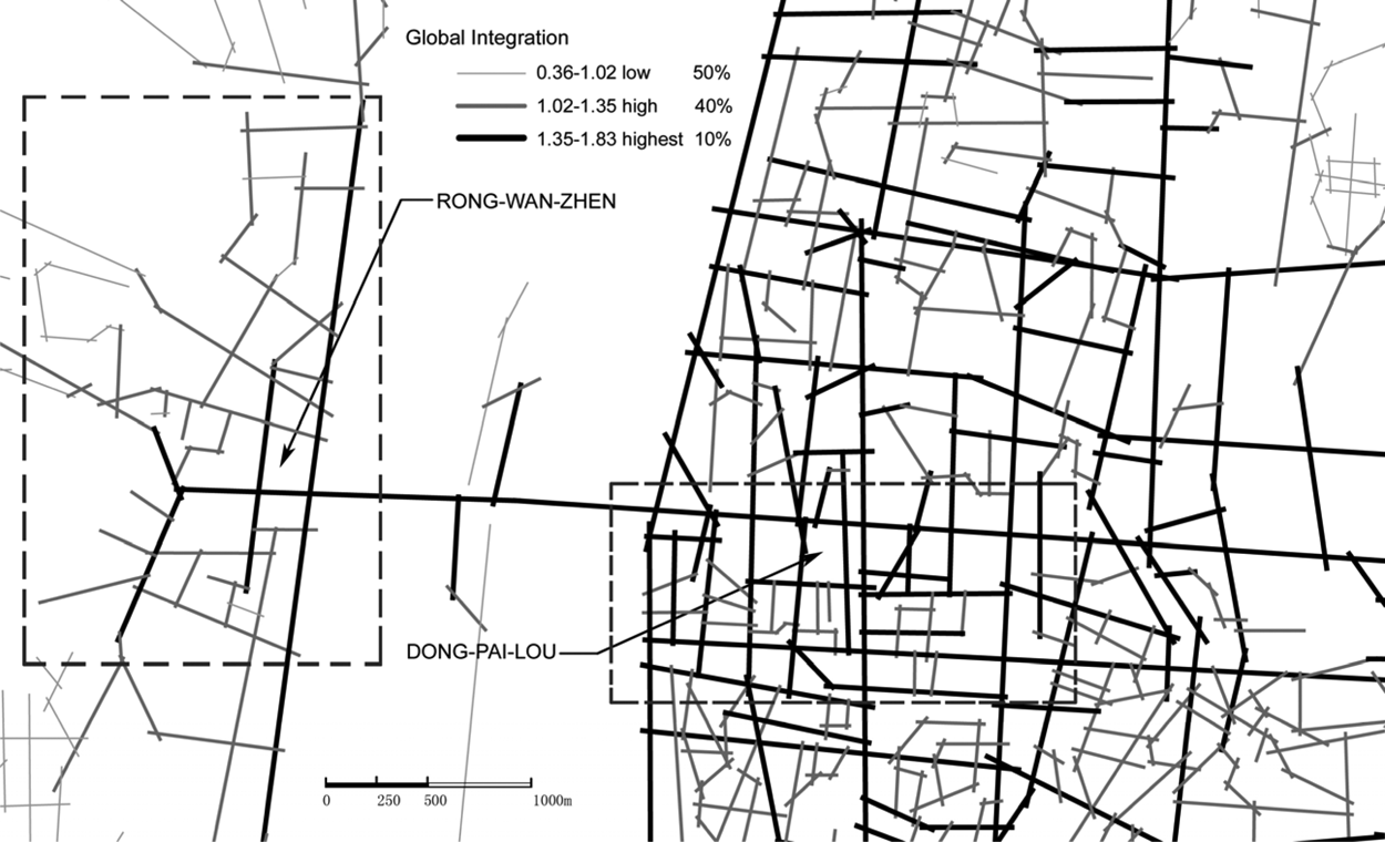
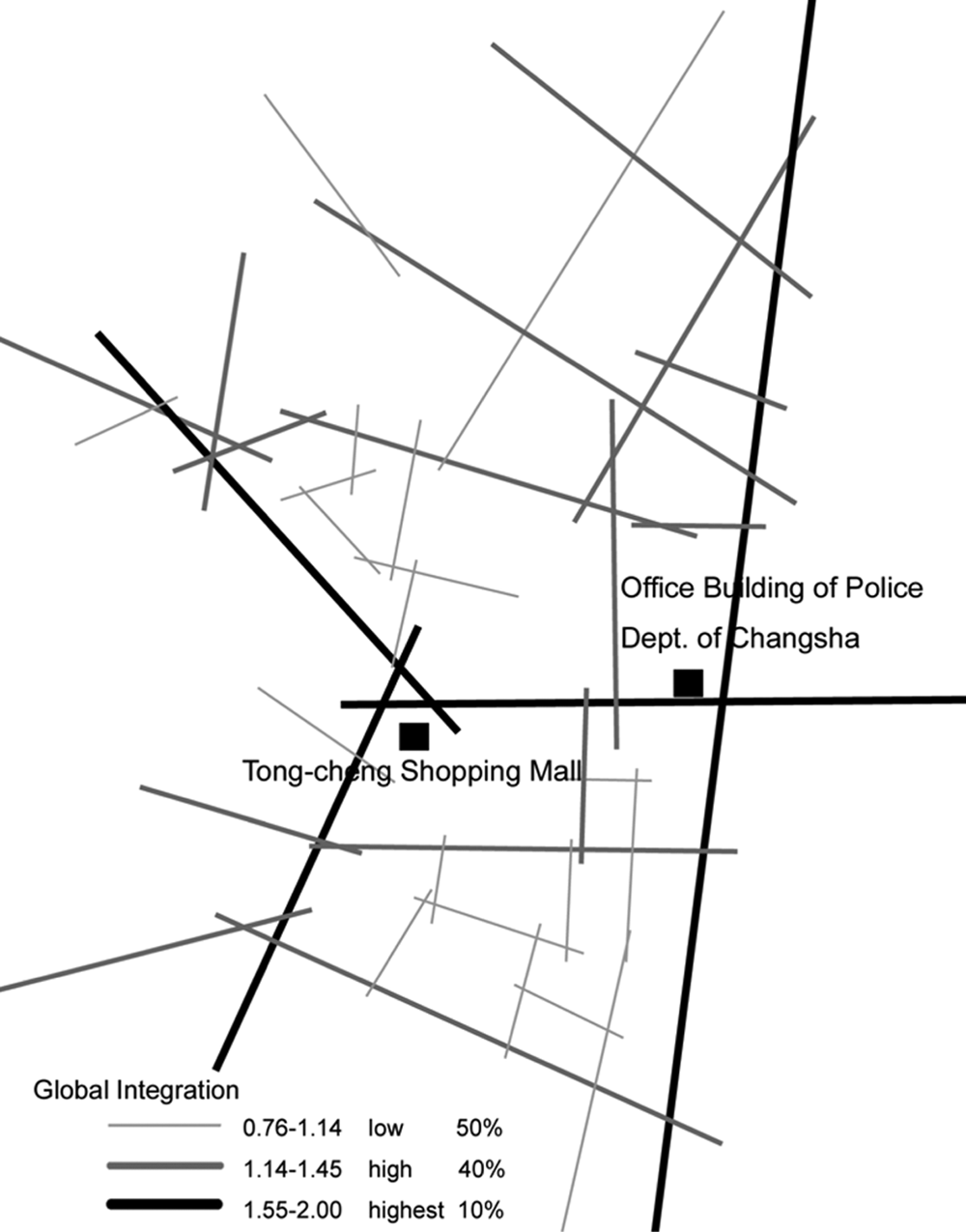
Global-integration map of the two neighborhoods within a global context
The global-integration values for the axial maps of the two neighborhoods without the surrounding area are shown in Figures 2a and 2b, whereas the syntactical characteristics of the study neighborhoods are summarized in Table 1. The R2 values between connectivity and global integration for the two neighborhoods indicate that the Dong-pai-lou neighborhood has a more-intelligible layout than the Rong-wan-zhen neighborhood. The axial map of the more-intelligible neighborhood (i.e., Dong-pai-lou; Figure 2a) illustrates that it has a fairly regular (rectilinear) street network and a “ringy” structure. Its L-shaped integration core stretches along north and west boundaries of the neighborhood and connects well with the rest of the area. Overall, the system is highly permeable inward as well as outward. This pattern points to a strong relationship between global and local configurational properties and indicates a clear relationship between the global and local structure. However, the less-intelligible neighborhood (i.e., Rong-wan-zhen) has a more tree-like structure and its Y-shaped integration core (Figure 2b) does not connect well with the north and south subareas of the neighborhood. The weak relationship between global and local spatial characteristics implies an unclear relationship between the global and local structure, which makes the system, as a whole, less intelligible. It is assumed that this difference in intelligibility (our independent variable) will play an important role in individual’s spatial cognition (i.e., place legibility).
Descriptive Statistics for Syntactical Characteristics of the Two Neighborhoods Without Surrounding Areas
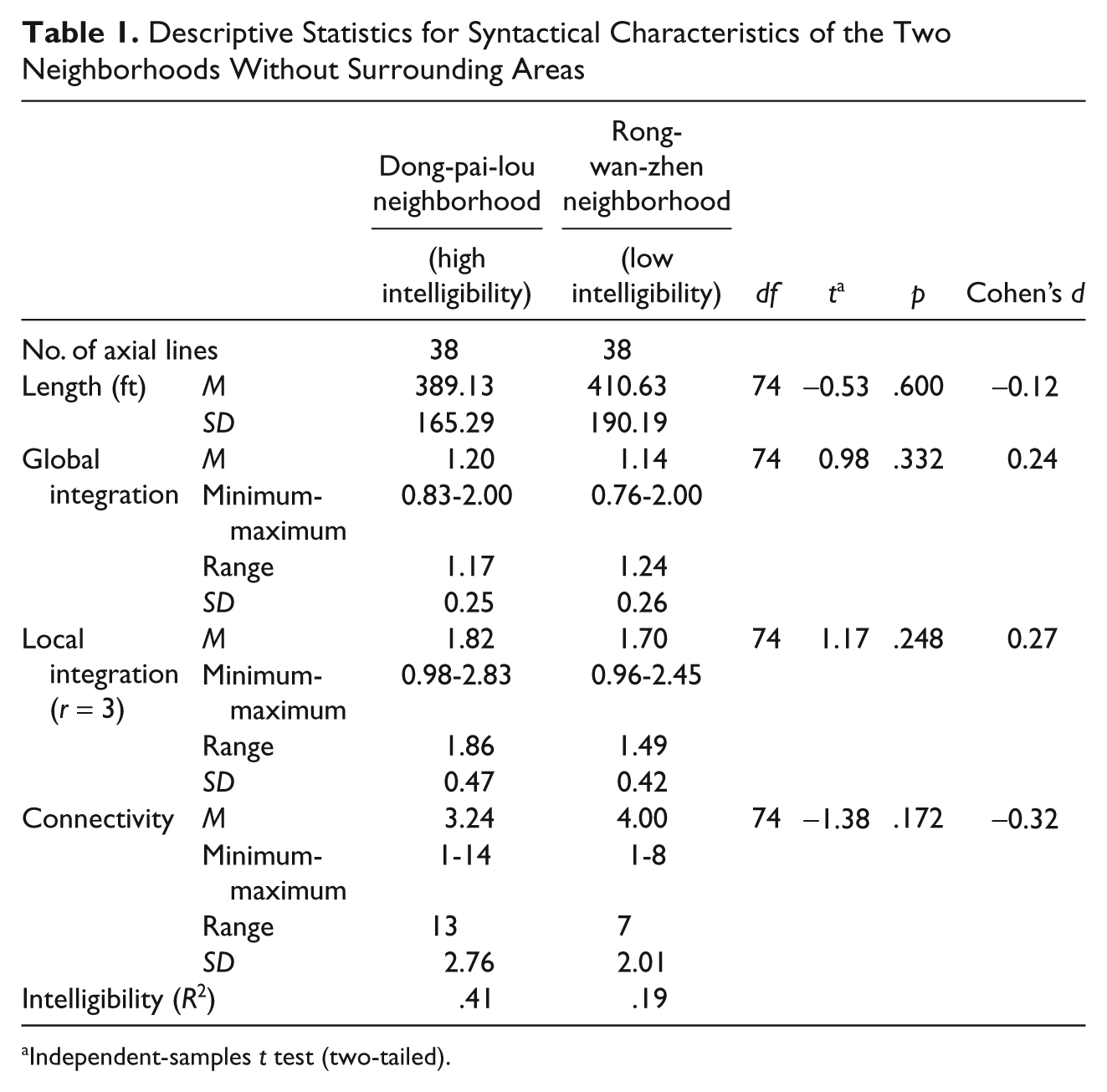
Independent-samples t test (two-tailed).

Global-integration map of Dong-pai-lou neighborhood (high intelligibility) without surrounding areas
Global-integration map of Rong-wan-zhen neighborhood (low intelligibility) without surrounding areas
Study Participants
Forty-nine volunteer students from Central South University in Changsha participated in the study. Students were screened for their familiarity with the neighborhood. None of the student participants had visited either neighborhood. Eligible students were first matched based on the spatial/visual-ability testing scores obtained from the “paper-folding test” developed by Ekstrom, French, Harman, and Dermen (1976) and gender. Second, those having the same gender and spatial-ability test scores were randomly assigned to two experimental groups. Of the 49 students, one student traveled outside the indicated neighborhood boundary and was excluded from the final sample. The final valid data set (described below) included 48 responses.
Data Collection and Experimental Procedure
Data for this study were obtained from sketch maps, scene-recognition tests, and postexperimental surveys. These techniques were utilized in combination to measure place legibility of study neighborhoods, which is the dependent variable. These techniques, in combination or individually, have been commonly utilized in spatial-cognition research (Evans, 1980; Evans, Skorpanich, Garling, Bryant, & Bresolin, 1984; Weisman, 1981; Yeung & Savage, 1996) to measure legibility. Data collection was carried out by six research assistants during 4 weekdays in December 2006.
The study utilized a posttest-only two experimental group design (Shadish et al., 2002). First, the participants met in a central location in one of the assigned neighborhoods and were asked to freely explore the neighborhood for an hour. In studying spatial cognition, free exploration has been utilized at a building scale (Haq, 2003; Haq & Zimring, 2003; Peponis et al., 1990). Each participant was instructed to learn about neighborhood layout and other physical features as best as they could. They were given a note with the names of the streets that comprised the neighborhood boundary to ensure that they would stay within the neighborhood limits. Following the exploratory travel, participants returned to the starting location. There, they were first asked to draw a sketch map of the neighborhood they just explored. Then, a scene-recognition test was carried out and, finally, a brief survey was conducted. Next, the three data-collection techniques are briefly described.
Sketch-mapping task
Following the exploratory travel, participants were first asked to draw a sketch map of the spatial layout of the neighborhood just explored, including roads/streets, buildings, and open spaces that they remembered. They were also asked to write down the names of the streets and buildings they remembered. As suggested elsewhere (Kim, 2001; Kim & Penn, 2004), to set a uniform scale and orientation, the Ju-zhi-zhou Bridge and Xiang River were marked on blank A4-sized papers. This stage lasted about 15 min. Examples of sketch maps from the two neighborhoods are shown in Figures 3a and 3b.
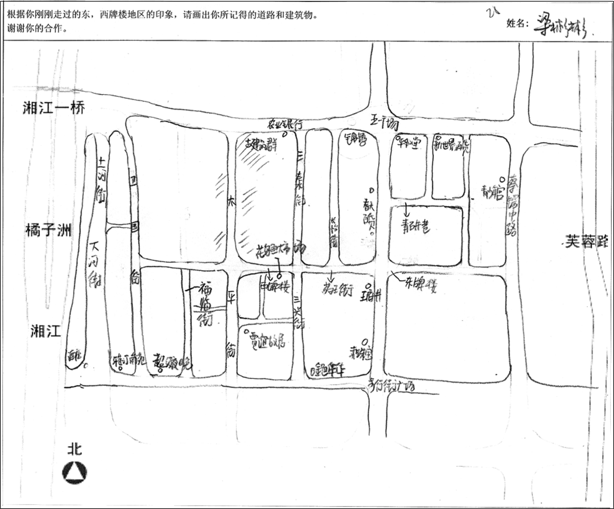
Sample of a sketch map of Dong-pai-lou neighborhood (high intelligibility)
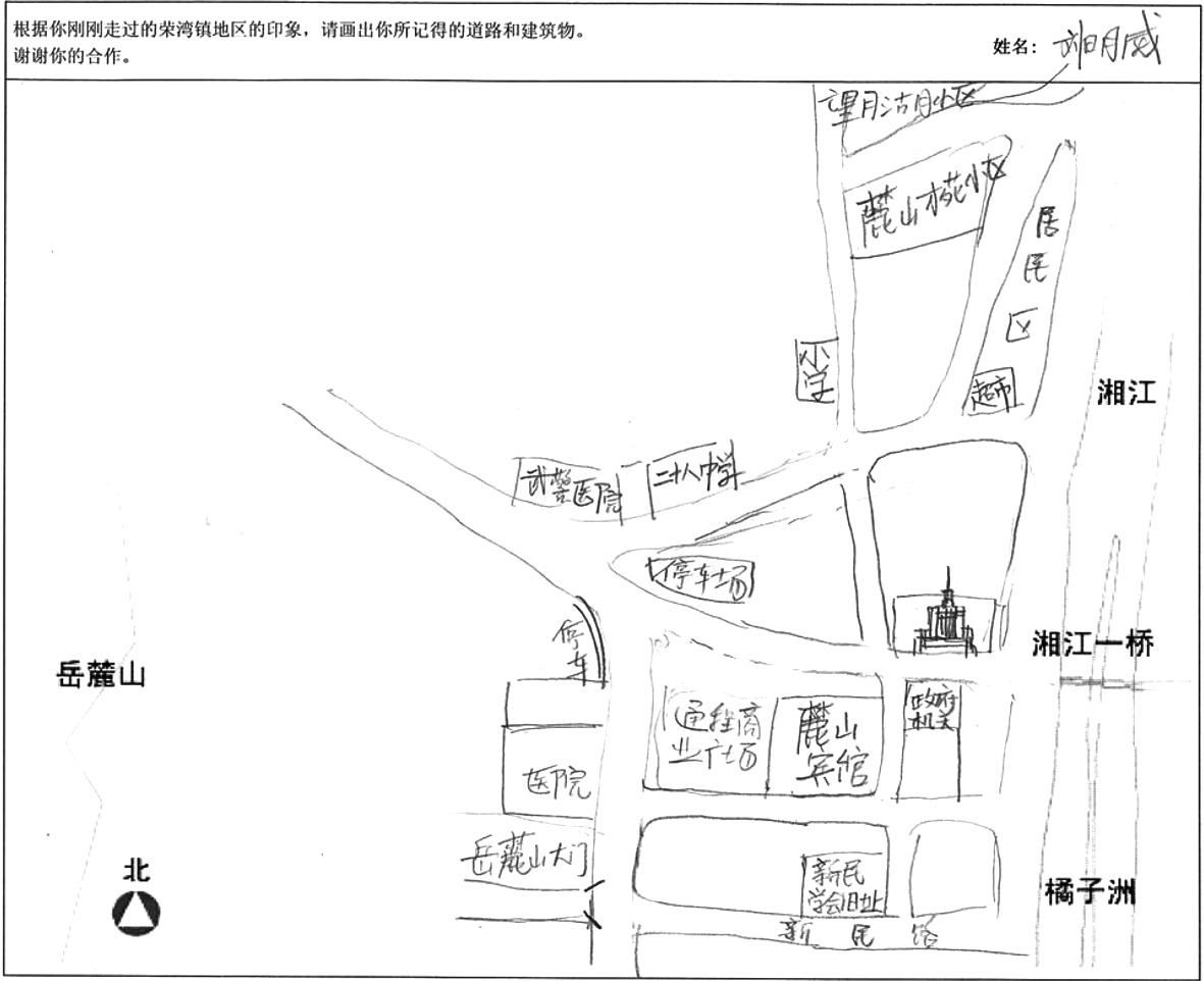
Sample of a sketch map of Rong-wan-zhen neighborhood (low intelligibility)
Scene-recognition test
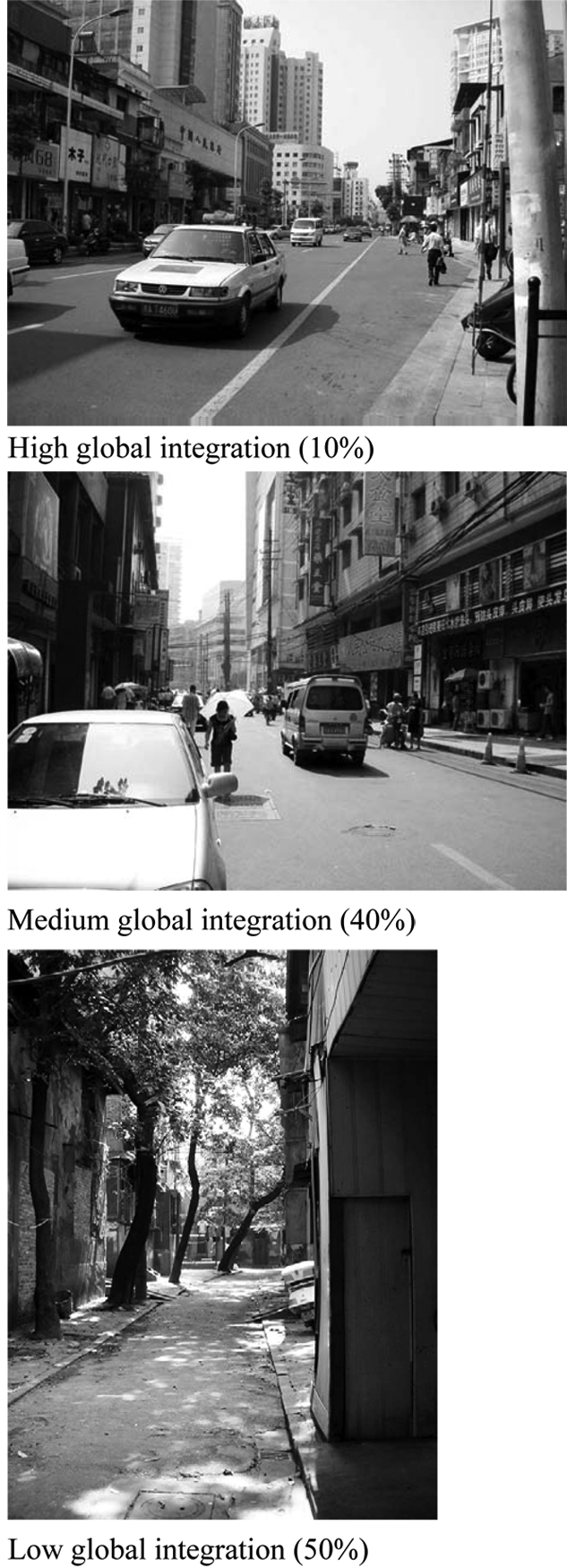
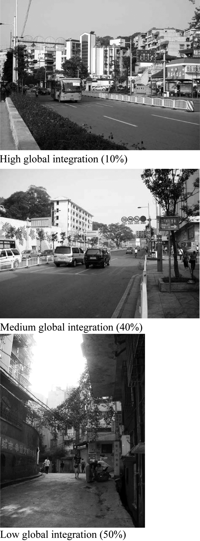
The second task comprised a scene-recognition test developed by Cohen (1980) and Evans et al. (1984). To ensure similar variation in global accessibility of the locations represented in the scenes of the two neighborhoods, the scenes were purposefully selected based on their location in the neighborhood street network. Twelve scenes along routes with high (the top 10% of high integration axial lines), medium, and low (the lowest 50% integration axial lines) global-integration values in each neighborhood were photographed before the experiment began. In addition, 4 scenes from other neighborhoods were included in the set of the photographs. In total, 16 scenes were included in the recognition test. These scenes were printed in high-resolution color images on A4-sized paper. Respondents were asked to locate each picture on a publicly available road map of the neighborhood. A sample of pictures used in the scene-recognition task is shown in Figures 4a and 4b.
Sample of scene-recognition pictures from high, medium, and low global-integration streets in Dong-pai-lou neighborhood (high intelligibility)
Sample of scene-recognition pictures from high, medium, and low global-integration streets in Rong-wan-zhen neighborhood (low intelligibility)
Postexperimental survey
Following the recognition test, participants responded to a short survey questionnaire. The survey lasted about 10 min and was designed to assess participants’ perceived spatial cognition and wayfinding ability. The five items included in the survey were based on the questionnaire developed by Weisman (1981), modified and simplified to correspond to the research goals of this study. The respondents were asked to indicate their degree of confidence and/or capability in (a) drawing the sketch map, (b) accuracy of their sketch map and recognition test, and (c) giving directions.
Data Analysis
First, a scoring schema to measure the frequency of physical elements (paths and landmarks) and the overall accuracy of each sketch map and the correctness of photo locations in the recognition test was developed. Second, a path score, landmark score, and scene-recognition score for each participant were calculated. Finally, a series of independent-samples t tests (two-tailed) was used to compare the mean scores obtained from each data-collection technique across the two experimental groups.
Sketch maps were evaluated following two ordinal-scale systems, one for paths and one for landmarks (buildings). The sketch-map evaluation approach was not based on space-syntax theory, as both scoring schemata considered the geometric accuracy of the elements included, not their syntactic accuracy. Guided by a methodology utilized elsewhere (Kim, 2001), the paths (streets) that were included in the sketch maps were scored on a 4-point ordinal scale ranging from 0 to 3 and included the following path/street categories: street did not exist in the sketch map, incorrectly drawn (wrong location or direction), partly correctly drawn (distortions in curve and/or angle), and correctly drawn. In addition, semantic parameters of the street structure were also considered by developing a second scoring schema that considered street names. This 6-point ordinal scale ranged from 0 to 5. Finally, for each respondent, a path score was calculated by summarizing scores for paths drawn by the respondent.
A similar scoring schema was developed for measuring the frequency and accuracy of landmarks. For each neighborhood, a list of buildings included in all sketch maps, considered to represent all landmarks in the neighborhood, was developed. Then, a 4-point ordinal scale was used to score landmarks in each sketch map. The scale ranged from 0 to 3 and included the following categories: landmark not drawn on the sketch map, incorrectly located, partly correctly located (along the right road/street, but in a wrong location), and correctly located. As all landmarks included in the sketch maps were correctly labeled, an alternative scoring system that included a combination with landmark naming was not developed. Each respondent’s landmark score was calculated by summarizing scores for landmarks drawn by the respondent.
The scene-recognition test was scored to measure the accuracy of the scene location. A 3-point scale ranging from 0 to 2 included the following categories: incorrectly located scene, partly correctly located scene (the scene corresponds to a correct block segment but beyond the correct location or it is around the corner of the intersection), and correctly located scene.
The questionnaire included the following measurements. The level of easiness/difficulty of drawing the sketch map and the three questions regarding the degree of confidence in the accuracy of the sketch map, in the location of the scenes/photographs, and in giving direction to strangers were measured on a 5-point ordinal scale. Whereas the capability of giving directions to a stranger was measured on a 3-point ordinal scale (i.e., yes, fair, no).
Results and Discussion
In the first stage of analysis, the role of intelligibility in path knowledge was examined. As shown in Table 2, the analysis of sketch maps illustrates that the large difference between the mean participant’s path scores between the more-intelligible and less-intelligible neighborhoods (M = 28.44, SD = 9.96 and M = 10.04, SD = 6.21, respectively) is statistically significant (p < .001). Similar results are found for path scores that considered street naming (not shown). As expected, confirming previous findings from a cross-sectional study (Kim, 2001), the results indicated that participants were able to more accurately draw the paths in the more-intelligible neighborhood than in the less-intelligible neighborhood.
Path Scores, Landmark Scores, and Scene-Recognition Scores for the Two Neighborhoods

Independent-samples t test (two-tailed).
In the second phase, the analysis of the accuracy of the landmarks drawn in the sketch maps showed that the mean landmark scores for the more-intelligible and the less-intelligible neighborhoods were 11.60 (SD = 7.87) and 10.70 (SD = 7.12), respectively (p = .68; Table 2). Contrary to expectations, the results revealed that there is no significant difference in participants’ landmark scores between the more-intelligible and less-intelligible neighborhoods.
The above results indicate that intelligibility plays a role in the path knowledge but not landmark knowledge. This finding could be explained by the fact that the axial map (hence intelligibility) captures the structural sense of the city (Dalton & Bafna, 2003) and focuses on describing the characteristics of spatial configuration, that is, street network, and not the characteristics of landmarks/buildings. As in high-intelligible environments it is expected that individuals will understand the overall structure easier by using the information available at a local scale, it is anticipated that intelligibility will contribute to the development of path knowledge. However, the landmarks, which Dalton and Bafna define as “second-order elements,” are predominantly visual and may not be integrally related to the urban structure (Dalton & Bafna, 2003).
In the third stage of the analysis, the scene-recognition test results (Table 2) show that the mean test score for the more-intelligible neighborhood is 6.72 (SD = 3.18), whereas the mean test score for the less-intelligible neighborhood is 4.70 (SD = 3.27; p = .04). Overall, confirming expectations, the results indicated that participants who explored the more-intelligible neighborhood were able to correctly recognize more scenes than those who explored the less-intelligible neighborhood.
The difference in recognizing more scenes from one neighborhood might be because of the existence of more distinctive landmarks along the paths included in the scenes of a more-intelligible neighborhood, as opposed to “no landmarks” (Evans et al., 1984). To assess the possibility of this alternative explanation, photographs of the actual landmarks included in the sketch maps were taken and their distinctiveness was measured using a 3-point ordinal scale based on the following four dimensions: visual distinctiveness, historical significance/meaning, function, and maintenance (Appleyard, 1969). A series of independent-samples t tests (two-tailed) were utilized to compare the mean scores for each dimension across the two neighborhoods. The results revealed that none of the differences in mean scores were statistically significant (not shown), indicating that no significant differences exist between landmark characteristics across the two neighborhoods. In addition, the occurrence of landmarks identified by participants in the pictures used for the scene-recognition test was also examined. Interestingly, fewer landmarks identified by the participants were captured in the pictures of scenes from the more-intelligible neighborhood than in the pictures of scenes from the less-intelligible neighborhood (4 and 6, respectively). Overall, the findings suggest that the difference in scene recognition between the two neighborhoods is due more to the overall layout of the neighborhood than to the characteristics or existence of the landmarks in the scenes. The results of the scene-recognition test are parallel to the findings about the role of intelligibility in developing path knowledge. Namely, the results confirm that intelligibility plays a role in scene recognition in general.
In the fourth stage of the analysis, the results of the postexperiment survey indicate differences between the two neighborhoods (Table 3). As Table 3 shows, the mean scores for all three questions that focus on perceived spatial-cognition ability (degree of easiness in sketch-map drawing, degree of confidence in sketch-map drawing, and degree of confidence in scene recognition) are much higher in the more-intelligible neighborhood than in the less-intelligible neighborhood (for all items p < .05). These findings are similar to the findings of the sketch-map analysis and the scene-recognition tests. Contrary to the perceived spatial cognition, the results did not indicate statistical difference in perceived wayfinding ability between the two neighborhoods (for both items p > .05).
Perceived Spatial Cognition and Wayfinding Ability for the Two Neighborhoods

Independent-samples t test (two-tailed).
Scale: 4 = very easy; −4 = very difficult.
Scale: 4 = quite confident; −4 = not at all.
Scale: 3 = yes; 2 = fair; 1 = no.
Conclusions and Directions for Future Research
This study examined if the intelligibility of a neighborhood layout influences the perceived neighborhood legibility as measured by sketch maps, recognition tests, and surveys. Our analysis shows that the differences in the three major measures of place legibility between the two neighborhoods with different degrees of intelligibility are significant. Specifically, the study found that participants who explored the more-intelligible neighborhood had more accurate path knowledge, recognized more scenes from the neighborhood, and had more confidence in their spatial-cognition abilities than those that explored the less-intelligible neighborhood. Contrary to our expectations, the results of the study indicated that intelligibility does not play a role in landmark knowledge. Overall, the study findings suggest that intelligibility influences perceived legibility.
There are two limitations to the present study. First, the study included only two study areas that limit the generalizability of the findings. Second, one of the neighborhoods (the more-intelligible neighborhood) has a more rectilinear street network and a more ringy structure than the other one (the less-intelligible neighborhood). Intuitively, it is expected that a more regular and/or a more ringy street structure will be more intelligible than a nonregular (more angular) and/or a tree-like structure. However, it is possible that these dissimilarities may have accounted for some of the differences in perceived legibility. To shed light on the role of these factors, and thus, enhance the generalization of the current study findings, future research should examine the linkage between intelligibility and place legibility in a number of other areas. In addition, research should investigate how the degree of intelligibility relates to the difference between ringy and tree-like configurations as well as the difference between geometric regular and irregular configurations. Nevertheless, the advantage of utilizing the concept of intelligibility over other structural qualities lies in the fact that it describes the aspects of spatial structure analytically and quantitatively.
In addition, future research should examine a number of other related issues. The current study focused on individuals unfamiliar with the environment; however, understanding the role of familiarity in the linkage between intelligibility and spatial knowledge would be worthwhile. Existing research (Kim, 2001; Kim & Penn, 2004) suggests that similar findings could be expected if participants had repeated experiences with the environment. In addition, this study was not designed to test how the placement of landmarks within the path structure contributes to spatial knowledge, another promising area for future inquiry.
As urban planners and designers seek to create legible environments, it is important to have effective measures of legibility. One indirect method, commonly utilized by researchers, is to measure wayfinding performance, which is the outcome of legibility of an environment. Legibility has also been measured by the accuracy of sketch maps of the built environment or the correctness of recognizing pictures of the environment in a simulated or natural setting. More recently, one study has attempted to measure legibility of the environment utilizing an expert panel (Ewing et al., 2006). However, the measure had low intra-class correlation coefficient (ICC = 0.38). All these approaches for measuring legibility are relatively inconvenient and time-consuming. In comparison, space-syntax measures, including intelligibility, are easier and less time-consuming to implement and compute. In addition, they can be calculated during the design phase, which is a significant advantage for design practice and decision making. Overall, this study provides evidence supporting use of a space-syntax approach to understand and quantitatively measure and manipulate intelligibility, which contributes to improved place legibility.
Footnotes
Declaration of Conflicting Interests
The authors declared no potential conflicts of interests with respect to the authorship and/or publication of this article.
Funding
The authors received no financial support for this research and/or the authorship of this article.