
Abstract
Despite growing concerns about the possible security implications of extreme precipitation shortfalls in vulnerable and politically fragile regions, the particular conditions that make armed violence more or less likely in times of drought remain poorly understood. Using a spatially disaggregated research design and focusing on sub-Saharan Africa, the present analysis assesses how far violent and nonviolent outcomes in the wake of drought can be accounted for by regional differences in the provision of key infrastructures that help coping with drought and preventing violence. The results indicate that civil conflict events in connection with drought are more likely in administrative areas with poorly developed road infrastructures. Drought-related communal violence, on the other hand, is more likely in regions where an important part of the population lacks access to an improved water source. Thus, while the provision of key infrastructures seems to moderate local conflict risks in connection with drought, there are nevertheless important distinctions with regard to different types of infrastructures and forms of armed violence. However, the importance of precipitation shortfalls as a conflict-facilitating factor in sub-Saharan Africa should not be overstated, as the overall contribution of drought measures to predicting violent events is modest in all calculated models.
Keywords
Introduction
Recent years have seen a surge in the number of studies on possible linkages between climate variability and armed conflict. As sudden changes in temperature and precipitation are expected to become more frequent in certain areas due to climate change, researchers and practitioners alike have become increasingly worried about the security implications of extreme events such as droughts. Within this strand of research considerable attention has been given to sub-Saharan Africa, as high dependence on rain-fed agriculture, social divisions and limited coping capacities would make the region particularly vulnerable to both weather extremes and violent conflicts (Boko et al., 2007; Stern, 2007; Hendrix & Glaser, 2007; Gleditsch, 2011).
Despite the popularity of this argument, findings of large-N analyses are inconclusive and evidence for a direct link between climate variability and conflict in Africa is generally weak (Salehyan, 2014; Buhaug, 2015). Miguel, Satyanath & Sergenti (2004) reveal correlation patterns between abrupt rainfall shortages and the incidence of armed conflicts in sub-Saharan countries. Hendrix & Salehyan (2012), on the other hand, find that years with more abundant rainfall are more likely to see armed violence. Burke et al. (2009) do not find a conflict-inducing effect of rainfall. They do however show that sub-Saharan countries are more likely to experience civil wars in warmer years. Yet, the robustness of their findings is challenged by Buhaug (2010).
More recently, these studies have been criticized for using country-level measures of climate and conflict. As argued by Theisen, Holtermann & Buhaug (2011/12) such aggregated measures might mask important local variations, as both adverse weather events and armed violence are localized phenomena. In response to this shortcoming, more recent studies have moved to analyse climate-conflict linkages at the subnational level. Their findings are inconclusive as well. Studying the effect of rainfall and temperature deviations on the likelihood of communal conflicts in Kenya, Theisen (2012) concludes that local instances of below average rainfall tend to have a pacifying effect. Raleigh & Kniveton (2012) assess that both positive and negative rainfall deviations increase the local risk of armed violence in East Africa. Yet, their findings differ with regard to different types of conflicts, communal violence being more likely in periods of abundant rainfall and state-based conflicts more likely during drought. O’Loughlin et al. (2012), on the other hand, conclude that violent events in East Africa do not necessarily occur during extremely dry periods. They do find, however, that warmer-than-normal temperatures raise the local risk of violence. Finally, Theisen, Holtermann & Buhaug (2011/12) do not find any significant relationship between armed conflict and various local indicators of drought in sub-Saharan Africa.
The inconsistency of previous findings might stem from a lack of involvement with the particular conditions that make armed violence more or less likely in times of environmental stress. So far, the majority of large-N analyses have examined direct correlations between indicators of climate variability and conflict, thus implying a near-deterministic relationship between both. Yet, adverse weather conditions can be assumed to have quite different consequences depending, among other things, on the level of resilience and cohesion among affected societies (Buhaug, 2015). Quantitative researchers are gradually becoming aware of this problem. A handful of recent analyses have started to account for conditional effects of drought on the likelihood of armed violence, depending, for example, on the political influence of drought-affected communities (Fjelde & von Uexkull, 2012; Theisen, Holtermann & Buhaug, 2011/12) or the frequency of intercommunity dialogue (Linke et al., 2015). However, such analyses remain the exception and a number of relevant contextual factors have not been considered yet. In particular, the extent to which regional inequalities in the provision of physical infrastructures moderate the local risk of conflict in connection with drought has not been systematically assessed so far.
In the following, I investigate the linkages between drought exposure, poor access to essential infrastructures and a higher risk of conflicts. More specifically, I focus on transport and water infrastructures, which strongly influence possible responses to extremely dry conditions, and hence are assumed to play a critical role in mitigating drought-induced stresses on individuals and societies. The analysis is set at the subnational level in order to capture local variations in terms of drought exposure and infrastructural development. These variations, I argue, need to be considered in order to understand where and why armed conflicts erupt in connection with drought.
Separate analyses are conducted for armed conflicts opposing organized rebel groups and governments (state-based or civil conflicts) and less organized forms of violence between communal groups (communal conflicts). Both conflict types are frequently considered in large-N research on climate variability and conflict. Yet, they are assumed to have different causes and dynamics and hence might show a distinct relationship (if any), with specific combinations of environmental and socio-economic variables (e.g. Fjelde & von Uexkull, 2012; Theisen, Holtermann & Buhaug 2011/12).
The second section develops my theoretical argument further and proposes different hypotheses regarding the local likelihood of armed conflict in the presence of drought and poorly developed infrastructures. The third sections goes on to present the research design and data. The fourth section presents the results of the empirical analysis. The fifth and last section discusses these results as well as their wider implications.
Droughts, infrastructures and local conflict risk
Precipitation levels strongly influence the availability of water and other resources that are essential to rural livelihoods. Due to a lack of irrigation facilities, rains are the main source of water for crops and livestock in large parts of sub-Saharan Africa (Calow et al., 2010). Rainwater availability usually varies across seasons and subsequent years and rural communities have learnt to account for such fluctuations when planning crops and herd movements. Especially, dry periods are a recurring challenge and agricultural producers have devised a number of strategies to cope with such conditions. However, when negative rainfall deviations strongly exceed expectations, established strategies might not work and the consequences can be disastrous: loss of livelihoods, widespread poverty, mass displacements and food insecurity (Meierding, 2013; Maystad & Ecker, 2014).
It has been argued that such conditions would facilitate insurgencies, as they provide rebel groups with greater opportunities to mobilize support among local populations (Theisen et al., 2011/12). On the one hand, food insecurity and loss of livelihoods in the wake of drought can produce resentment against a government that fails to address urgent needs for relief (Slettebak, 2012; Koubi et al., 2012). Similarly, a government that spends few resources to prepare and protect local populations against adverse weather events is likely to be held responsible when pressures from drought become unbearable. These grievances can become particularly serious when much-needed resources are diverted to other uses, providing challengers to the government with additional opportunities to mobilize support (von Uexkull, 2014). Examples for this can be found in both Mali and Niger in the early 1990s, where, among other reasons, Tuareg insurgencies gained considerable momentum because governmental officials in Bamako and Niamey were embezzling international relief aid destined for drought-affected communities in the northern Sahel (Benjaminsen, 2008).
On the other hand, droughts also provide favourable conditions for rebels to recruit fighters among rural dwellers who have lost their livelihoods (von Uexkull, 2014; Justino, 2009). There is indeed anecdotal evidence that during the drought and famine of 2011–12, a number of Somalian pastoralists joined the ranks of the extremist organization Al Shabaab, which used a combination of cash payments, promises of regular wages and threats of violence to recruit new fighters (Maystadt & Ecker, 2014). In a similar fashion, Nillesen & Verwimp (2010) find that recruitment by rebels in the Burundian civil war was more successful in villages that had recently been affected by extreme weather events. Much like in the Somalian case, material benefits and the promise of future rewards were central elements of the rebels’ recruiting strategy.
But droughts could just as well lead to local disputes between communal groups, as suggested by numerous case studies (e.g. Opiyo et al., 2012; Benjaminsen et al., 2012). Precipitation shortages put severe strains on essential resources and can increase competition over access to land and water (Fjelde & von Uexkull, 2012; Eriksen & Lind, 2009; Linke et al., 2015). Tensions can arise, for instance, when extended dry spells force herders to stay longer than usual in areas that are also used for agriculture. In the absence of effective dialogue and arbitration such situations can lead to overt violence, especially when political elites stand to gain from fuelling interethnic disputes, as seen in Kenya’s Tana River Delta (Kirchner, 2013).
In addition, drought conditions can provide both motivation and opportunity for predatory behaviour and hence lead to the escalation of communal violence when conflict prevention fails. For one part, loss of livelihoods in the wake of drought can incite banditry. Examples for this can be found in the drylands of Kenya, Uganda and South Sudan, where a number of herders engage in cattle raiding as a way to compensate for drought-induced economic losses (Meier, Bond & Bond, 2007; Schomerus et al., 2010; Schilling et al., 2012; Adano al., 2012). For the other part, drought-affected people often have to travel greater distances in order to access more scattered resources and hence become easier targets for potential attackers. For instance, drought conditions in northern Kenya force Turkana pastoralists to graze more frequently on the margins of their territory, where they are susceptible to attacks by Pokot and Toposa raiders (Eriksen & Lind, 2009; Opiyo et al., 2012). Such incidents usually involve only a few people, but, if not properly addressed, they can set in motion a spiral of increasingly violent revenge attacks between communal groups (see Eaton, 2008).
However, it should be clear that neither of the arguments above describes a deterministic relationship. Droughts can facilitate and encourage armed violence, but only if they meet otherwise favourable conditions for conflict, such as pre-existing grievances, weak institutions, or an unresponsive government (Raleigh, 2010; Theisen et al., 2011/12; Slettebak, 2012). More specifically, the extent to which farmers and herders are likely to suffer from drought will depend on their ability to adapt and access essential services; and the extent to which drought-induced losses and grievances are likely to contribute to armed violence will depend on the ability and willingness of state and civil society actors to mitigate environmental hardships and prevent the escalation of disputes.
These conditions, in turn, are shaped to an important extent by development policies and the spatial allocation of public goods (Eriksen & Lind, 2009; Linke et al., 2015), implying that even within the same country there can exist important regional differences in the way a drought is experienced and dealt with: subnational regions lacking essential infrastructures and services are more likely to experience the adverse effects of drought, because of limited coping options and reduced possibilities for public authorities and civil society actors to intervene (Midgley, Davies & Chesterman, 2011; Abson, Dougill & Stringer, 2012). Hence, their inhabitants might be more inclined to fight over scarce resources or join a rebel group when a drought is threatening their livelihoods. In addition, failure to cope with drought in such areas is likely to be blamed on the governments’ inability or apparent unwillingness to provide local communities with the necessary means to do so. In fact, droughts might reveal more pervasive inequalities between regions that are well integrated into the economic and political life of the state and regions that are not. Thereby droughts might contribute to both anti-state grievances and a general feeling of abandonment, which can encourage violent self-help strategies (Theisen et al., 2011/12; Raleigh, 2010).
In particular the quality and extent of transport infrastructures influence the capacities of local communities to withstand extreme weather events. Roads allow access to markets and towns, where drought-affected people can diversify their livelihoods, obtain additional agricultural inputs, access veterinary services, or sell weakened animals before they die. But they can also be used by the government and NGOs to deliver food aid and assist drought-stricken populations (Schilling et al., 2011; Deligiannis, 2012; Brooks, Adger & Kelly, 2005).
Moreover, roads play a crucial role in preventing drought-related conflicts. A good transportation network facilitates the transport of military personnel and supplies and hence allows security forces to quickly react to possible outbursts of violence, which can discourage both rebel activities and communal conflicts (Adger et al., 2004; Zhukov, 2012). For instance, Schilling et al. (2011) emphasize the importance of road infrastructures for a timely prevention of revenge attacks between Turkana and Pokot pastoralists in northwest Kenya.
Finally, roads usually make up an important part of public expenditures. Thus, the quality and extent of local transportation infrastructures is often an indicator of the importance attached by the government to a particular region. In Kenya, for instance, Burgess et al. (2015) find for the period 1963–2011 that districts where the majority of the population shared the ethnicity of the incumbent president received twice as much expenditure on roads and had almost five times the length of paved roads built compared with what would be predicted from their population size. A poorly developed transportation network in comparison with other subnational regions is thus not only a factor of vulnerability but also a possible sign of political marginalization and strained relations with the capital region (Linke et al., 2015; Raleigh, 2010).
Summing up, there are thus several reasons to assume that regions with poorly developed road infrastructures are not only more vulnerable to the adverse effects of drought, and hence more likely to see drought-stricken populations joining armed groups, but also more likely to see armed groups taking advantage of inaccessible terrain and a generally weak involvement of the state.
Proposition 1: Subnational regions with comparably poor road infrastructures are more likely to experience civil or communal conflicts in the wake of drought.
In a similar fashion, coping with precipitation shortfalls is easier when affected populations have access to alternative water sources (e.g. groundwater or piped water). In many parts of rural sub-Saharan Africa access to groundwater in deep wells and boreholes is crucial when surface water sources and shallow wells dry up (Calow et al., 1997; Deressa, Hassan & Ringler, 2008). Significant efforts have been made to improve farmers’ and pastoralists’ access to groundwater, but there remain important regional and rural–urban disparities (Niang et al., 2014). In many areas, the potential for water extraction is not fully exploited because of a lack of adequate infrastructures (Calow et al., 2010; Carter, 2006).
Where there are only a few access points, droughts can lead to the localized depletion of aquifers, due to overextraction. Heavy reliance on single water sources during dry periods can also strain pumps and lead to mechanical failures, thus further compromising water security (Calow et al., 2010). Moreover, the concentration of people and livestock around just a few wells can lead to the deterioration of surrounding land and pastures, thus exacerbating local conflicts over scarce resources (Mureithi & Opiyo, 2010). A limited number of deep wells and boreholes also implies that drought-affected villagers have to travel greater distances to fetch water, thus making them more vulnerable to attacks. This pertains especially to pastoralist areas where well sites are scantly distributed across the landscape (Schilling et al., 2012: 11; Witsenburg & Adano, 2009: 526).
Besides making local communities more vulnerable to both droughts and attacks, poorly developed water infrastructures can also be indicative of a lack of involvement by the government and thus correlate with anti-state grievances. Although water infrastructures in sub-Saharan countries are provided by different actors, including private and civil society organizations, central and local governments nevertheless assume an essential guiding and coordinating role, setting sector strategies, regulating the private sector and channelling donor funding. This is especially important in peripheral areas, where incentives for private actors to invest in the water sector are low and water infrastructures remain less well developed (Calow et al., 2010; Carter, 2006; Banerjee & Morella, 2011). Since public authorities can partly be made responsible for the state of local water infrastructures, difficulties in accessing groundwater resources in times of drought can be a cause of dissatisfaction with the government.
Proposition 2: Subnational regions with comparably poor water infrastructures are more likely to experience civil or communal conflicts in the wake of drought.
Research design and data
The framework above suggests that subnational regions with poorly developed infrastructures are more likely to experience civil or communal conflicts in the wake of extreme drought events. In order to test this proposition I utilize a spatially disaggregated research design, where the units of analysis are yearly observations within the first order administrative subdivisions of sub-Saharan countries between 1990 and 2010 (cf. Urdal, 2008; Østby et al., 2011; Fjelde & von Uexkull, 2012). Data on administrative boundaries are from the Global Administrative Unit Layers (GAUL: EC-FAO, 2008). The GAUL data take into account timely changes in administrative borders, due, for example, to the merging and splitting of administrative regions or to the redefinition of boundaries, and can thus be merged in a geographic information system (GIS) with time-varying data on local rainfall, armed conflicts and other variables.
The spatial aggregation into first order administrative subdivisions (i.e. provinces, states, regions) fits well with my theoretical argument about the importance of regional inequalities in the provision of essential infrastructures and services. In sub-Saharan Africa, the provision of public goods and the allocation of development projects often follow administrative boundaries, so that important differences with regard to welfare and development can be observed between provinces or regional states. Especially, administrative regions inhabited by politically marginalized communities are generally disadvantaged in terms of service provision and infrastructural development (Østby & Fjelde, 2012). In these regions, collectively experienced discriminations can foster a stronger sense of unity and resonate with rebels’ claims for greater regional autonomy (cf. Cunningham & Weidmann, 2010). Also, regional administrations often hold important powers with regard to land tenure legislation, market regulation and the allocation of state resources, despite different levels of political decentralization in sub-Saharan countries (Fjelde & von Uexkull, 2012). Thus, they also represent a meaningful context in many communal struggles over livelihood resources (Lund & Boone, 2013; Hagmann & Mulugeta, 2008). Also, I use yearly observations in each administrative unit to avoid overemphasizing tactical aspects that are related to short-term rainfall fluctuations, but fall outside the explanatory scope of this analysis (cf. von Uexkull, 2014). For example, rainy months provide more dense vegetation that can be used as cover by armed groups (Meier, Bond & Bond, 2007).
Civil and communal conflict incidence
Data on armed conflicts are from the UCDP Geo-referenced Event Dataset v.1.5-2011 (UCDP-GED: Sundberg, Lindgren & Padskocimaite, 2010). In the UCDP-GED dataset armed conflicts are defined as the use of armed force between two armed groups (i.e. governmental troops, rebel organizations, communal militias), resulting in at least 25 battle-related deaths in at least one year (Sundberg, Eck, & Kreutz, 2012). These are disaggregated into several violent events (i.e. battles or one-sided attacks resulting in at least one direct death) which are provided with dates and geographic coordinates, thus allowing the identification of administrative units, which hosted at least one violent event for each year considered in the analysis. To ensure consistency of the conflict data with the chosen level of aggregation, only conflict events with a geo-precision above or equal to the first order administrative sublevel are considered in the analysis.
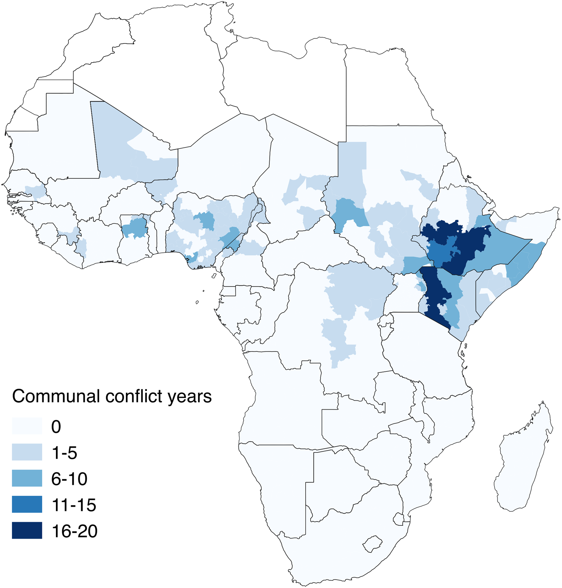
Based on these data I compute two dependent variables in order to conduct separate analyses for communal and civil conflicts: Civil conflict incidence is coded 1 for each year in which an administrative unit experiences at least one conflict event opposing a rebel group to the armed forces of an incumbent government and 0 otherwise. Communal conflict incidence is coded 1 for each year in which an administrative unit experiences at least one violent event involving the members of at least two different ethnic communities and 0 otherwise. Droughts might very well spark new conflicts, yet, in line with my theoretical argument, they are mainly expected to sustain and fuel ongoing disputes, for example by helping rebels to mobilize new fighters and gain a foothold in new territories, or by exacerbating recurring intergroup violence. Focusing on the incidence rather than the onset of armed conflicts thus seems appropriate here. Figures 1 and 2 show the frequency of administrative-unit-years with civil and communal conflicts in sub-Saharan Africa between 1990 and 2010. Most civil conflict observations can be found in Angola (179), Sudan (141) and Burundi (123). Most communal conflict observations can be
Frequency of civil conflict years in sub-Saharan Africa 1990–2010 Frequency of communal conflict years in sub-Saharan Africa 1990–2010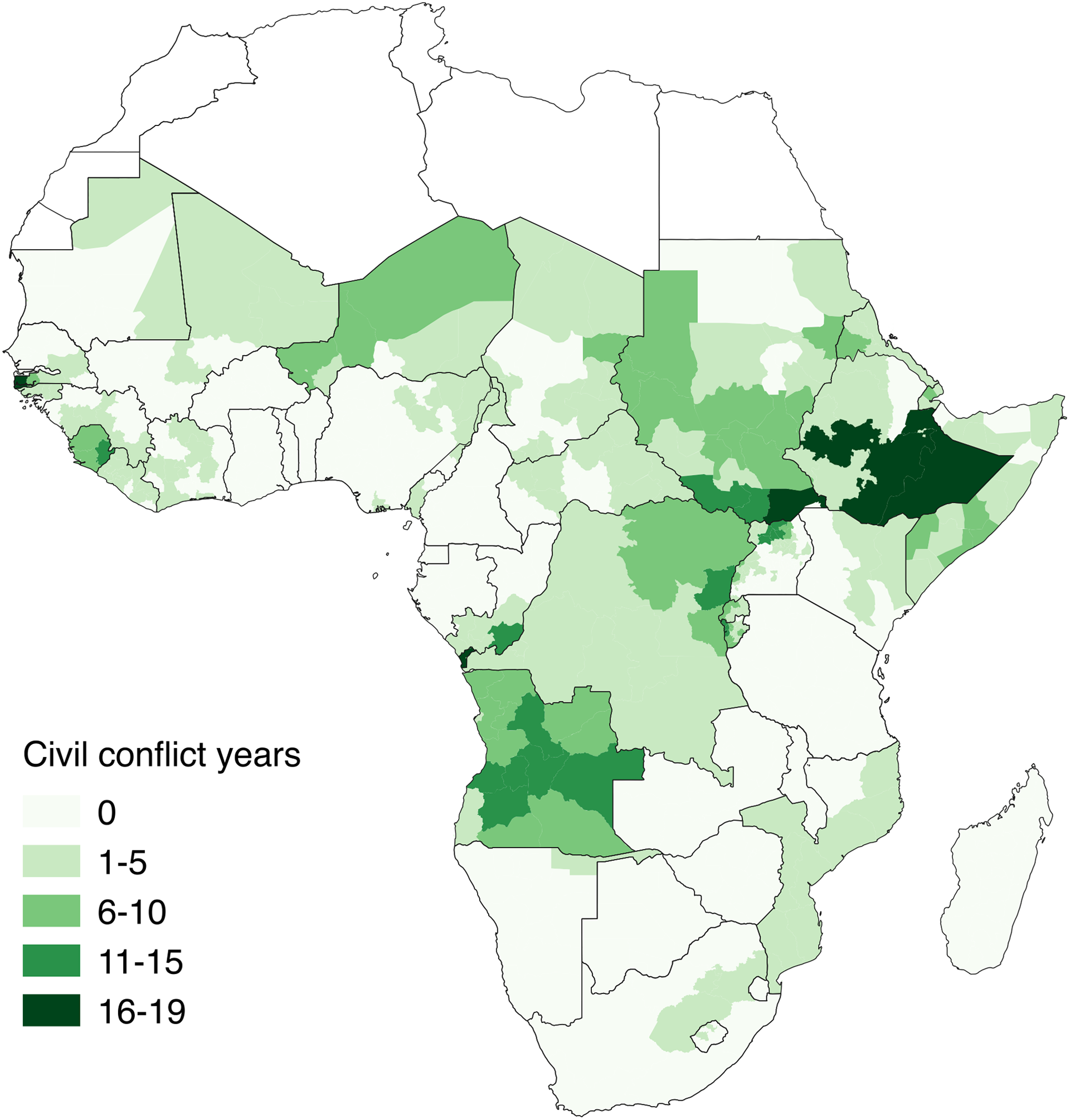
Drought
The main independent variable Extreme drought is based on the standardized precipitation index (SPI). The SPI measures the number of standard deviations that the observed cumulative rainfall over a specified period, usually six months, deviates from the historical mean for that same period. Precipitation time series for the specified period, usually spanning 30 years or more, are utilized to estimate an adequate probability density function and compute standard deviations from average rainfall, whereby large negative values indicate drought conditions (McKee, Doesken & Kleist, 1993; see also O’Loughlin et al., 2012: 18348; von Uexkull, 2014: 20). The SPI offers a simple and flexible measure with comparably low data requirements that yields comparable results across regions with different climatic conditions. Moreover, it has been shown to be a good predictor of drought in Africa (Ntale & Gan, 2003).
To compute the SPI, I use monthly precipitation raster data of the Global Precipitation Climatology Centre (GPCC – Full data reanalysis version 6.0: Schneider et al., 2011), which come at a resolution of roughly 278 km x 278 km. For each grid-cell-month in the GPCC data, I compute the SPI based on the cumulative precipitation in the six preceding months between 1981 and 2010. Probability distributions and standard errors are estimated via the R-package SPEI (Beguería & Vicente-Serrano, 2013). I choose a six-month frame for the SPI so as to capture rainfall patterns at a time scale relevant for agricultural production (see O’Loughlin et al., 2012). Following the example of Theisen, Holtermann & Buhaug (2011/12) and von Uexkull (2014), I then compute an annualized version of the SPI, whereby years with at least three consecutive months with values below –1 are defined as years with moderate drought conditions, years with at least two consecutive months with values below –1.50 are defined as years with serious drought conditions and years meeting both of the previous conditions are defined as years with extreme drought conditions.
In a final step, these data are aggregated to the level of administrative units. In line with the theoretical framework I expect both civil and communal conflicts to be more strongly correlated with extreme levels of drought, which surpass the anticipations of agricultural producers by far. Hence, I use a binary variable indicating administrative-unit-years that intersect with at least one grid-cell-year with extreme drought conditions. This operationalization takes into account that a region might still feel the full social and economic impact of a drought that is only partly covering its territory, as people migrate from severely to less severely affected areas. Figure 4 (Online appendix) shows the frequency of administrative-unit-years with extreme drought conditions between 1990 and 2010. Most drought observations can be found in Uganda (363), Tanzania (199) and Nigeria (187).
Low density of paved roads
Regional differences in the density of road infrastructures are measured with the help of road vector data from the Africa Infrastructure Country Diagnostic (AICD: African Development Bank Group, 2015). The data cover all sub-Saharan countries with the exception of Somalia and Chad. I focus on paved roads, as unpaved roads are recorded with varying degrees of precision and completeness across different countries. Also, the density of paved roads is a suitable indicator of state resource allocation, as paved roads represent a large investment. By spatial overlay with the administrative unit layer, I compute road densities, defined as the total length of paved roads in an administrative unit divided by the unit’s surface. Based on this measure, I then compute a binary variable indicating administrative units with road densities below the national median. I use deviations from the median rather than from the mean so as to dampen the effect of extreme observations, that is, high densities around capital cities and major urban centres. In line with the theoretical framework, I compute deviations from national medians rather than from the overall sample median, because I expect individuals to make within- rather than between-country comparisons, when assessing the government’s interest in their region. Also, the within-country measure allows me to factor out cross-country variations in the strategic relevance of roads, depending on country-specific attributes such as military strength or the government’s predisposition to use armed force. Figure 5 in the Online appendix shows the spatial distribution of administrative units with low road density.
Poor access to alternative water sources
Data on Access to water infrastructures is from the Demographic and Health Surveys (DHS: ICF Macro, 2014). The DHS contain detailed information on a variety of socio-economic attributes, as well as the location of more than 850,000 households across 43 sub-Saharan countries. Each country survey is divided into several sampling regions, which usually correspond to first-order administrative subunits and, depending on cases, comprise between 57 and 12,120 surveyed households (with an average of 1,145 households). Based on this information and using sampling weights provided in the DHS, I compute aggregate percentages of households with access to an improved water source for each sampling region. Improved water sources include piped water, tube wells/boreholes, standpipes and similar sources that offer access to groundwater and other water reserves in times of drought. The aggregated data are merged with the GAUL administrative unit layer by matching the names of DHS regions with the names of GAUL administrative units for the same year. In cases where DHS regions comprise more than one administrative unit, matching administrative units are assigned the same value. In the very rare cases where GAUL administrative units comprise more than one DHS region, administrative units are assigned the mean value of matching DHS observations.
DHS are only available for certain years, usually with five-year intervals between consecutive survey rounds. Yet, inspection of the raw data reveals that levels of access to improved water sources are serially correlated across successive survey rounds in the DHS (with r = 0.65), which allows me to extrapolate the last observed value in an administrative unit in order to get estimates for years between observations (while not exceeding a period of five years). Nevertheless, I acknowledge that more fine-grained timely data would have been preferable, if available. The resulting data are lagged by one year to reduce potential endogeneity with the dependent variable as much as possible. Finally, I compute a binary variable coded 1 for administrative units with access to improved water sources below the national median and 0 otherwise. Figures 6–9 (Online appendix) show the spatial distribution of the resulting measure for different survey periods of the DHS.
Control variables
The analysis includes measures of Population size and Lagged income, two variables that are often associated with a higher conflict risk in the literature (see Hegre & Sambanis, 2006). Both variables are also correlated with the density of road and water infrastructures and could possibly confound the observed relationship between infrastructural development and armed conflict. Log population is a logged measure of the absolute population size in each administrative-unit-year and is obtained through aggregation of Gridded Population of the World (GPW3) data (CESIN & CIAT, 2005). GPW3 data provide subnational estimates of population counts at a resolution of roughly 4.6 km x 4.6 km. Population counts for each observation are computed by taking the area weighted sum of all population grid cells falling within an administrative unit. Estimates in the GPW3 are available in five-year intervals between 1990 and 2010. The last observed values between observation years are used to obtain yearly estimates. The measure is subsequently log-transformed to account for extreme values.
Log income (t–1) indicates the logarithm of per capita income (given in 1995 $US at purchasing power parity exchange rates) in the previous year for each administrative-unit-year. It is based on G-Econ data (Nordhaus, 2006). G-Econ income raster data (roughly 112 km x 112 km) are provided for the years 1990, 1995, 2000 and 2005. I extrapolate the last observed value in order to get estimates for all years between 1990 and 2010. Lagged values of the G-Econ grid cells are then weighted according to the surface of the grid cell falling within an administrative unit and used to compute lagged mean per capita incomes for each administrative-unit-year (cf. Fjelde & von Uexkull, 2012: 449).
Spatial and temporal dependence
The data used in this analysis have the typical time-series–cross-section form of most econometric data in conflict literature. It is widely accepted that observations in such a data structure are not independent across time and across spatially proximate units (Gleditsch & Weidmann, 2012; Raleigh, Witmer & O’Loughlin, 2010). Armed conflicts are likely to spread to nearby countries and regions as they often spark large refugee movements and cross-border movements of armed groups, which can spur social tensions and latent insecurity. Likewise, armed conflicts leave a region in a desolate situation, which makes it susceptible to renewed conflict, while past atrocities can encourage retaliatory violence among previously victimized communities. In order to account for such effects, I follow the recommendation of Beck, Katz & Tucker (1998) and, depending on the model, include a series of dummy variables indicating the number of years since the last civil or communal conflict event for each administrative-unit-year. Spatial dependence is captured by a binary variable, which indicates whether a civil or communal conflict has been taking place in neighbouring administrative units in the previous year. Neighbouring administrative units are defined here as administrative units within a 150 km radius (cf. Fjelde & von Uexkull, 2012). I further account for the possible influence of civil conflicts on communal conflicts and vice versa by including spatial lags for both conflict types in each model.
Results
The results of the quantitative analysis are presented in Table I. With the exception of the income measure, all control variables behave generally as expected: consistent with previous analyses, I find conflict events to be more likely in populated regions, as well as in regions with a history of violence, or regions in proximity to other armed conflicts (c.f. Hegre & Sambanis, 2006; Gleditsch & Weidmann, 2012). Standard errors for the income measure are larger than expected in all models, yet this could be due to a high correlation with the population measure (see Table IV, Online appendix).
Models 1 and 4 estimate the unconditional effect of drought on civil and communal conflict incidence when no infrastructure variables are included in the model. Consistent with previous research, I do not find a significant effect on the likelihood of either form of armed violence (cf. Theisen, Holtermann & Buhaug, 2011/12; von Uexkull, 2014). Models 2 and 5 test the implications of Proposition 1. As expected, civil conflict events seem to be more likely in regions with drought conditions and a low density of paved roads, as shown by a positive and significant coefficient of the interaction term in Model 2 (p < 0.01). In regions with a high road density, droughts seem to reduce the risk of civil conflict incidence, although the coefficient is only significant at the 10% level. On the other hand, the risk of communal violence does not seem to be affected by extremely dry conditions, independently of the density of local road infrastructures. The opposite result is obtained with regard to Proposition 2. In Model 3 the coefficient of the interaction term between drought and poor access to improved water sources is not significant, whereas it is in Model 6 (p < 0.05), suggesting that water infrastructures influence the risk of communal violence in relation to drought, but not the risk of civil conflict incidence.
Logistic regression analysis
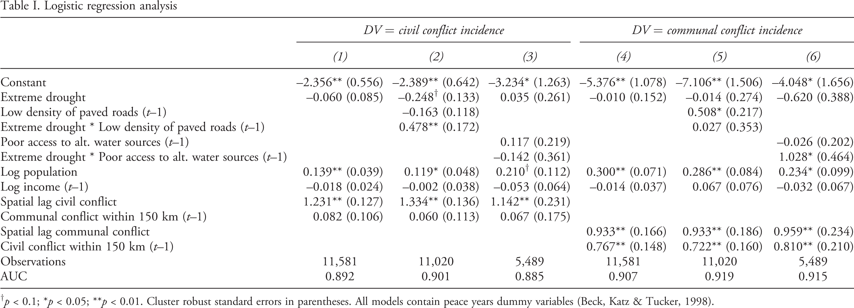
† p < 0.1; *p < 0.05; **p < 0.01. Cluster robust standard errors in parentheses. All models contain peace years dummy variables (Beck, Katz & Tucker, 1998).
As an additional test, I calculate the predictive power for each variable in Models 2 and 6, based on the contribution of each variable to the overall prediction accuracy of the model (cf. O’Loughlin et al., 2012: 18347). Changes in the prediction accuracy are measured as changes in the area under the curve (AUC) metric when specific variables are introduced in a model that did not contain them beforehand (see Table II). The largest increases in the AUC can be observed when introducing spatial and temporal lags of the dependent variable. In contrast, the contribution of the drought measure and its interaction terms is limited, implying that droughts are less important for predicting armed conflicts than other variables such as previous violence and nearby conflicts.
Predictive power for variables in Model 2 and Model 6
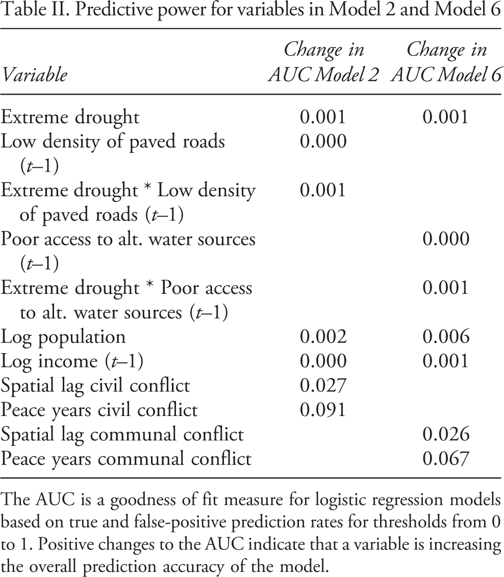
The AUC is a goodness of fit measure for logistic regression models based on true and false-positive prediction rates for thresholds from 0 to 1. Positive changes to the AUC indicate that a variable is increasing the overall prediction accuracy of the model
As can be seen from the upper part of Figure 3, the effect of extreme drought conditions on the risk of civil conflict incidence is positive and significant in regions with poorly developed road infrastructures (on average 28% higher risk with a 95% confidence interval between 4% and 55%), but not in regions with comparably better road infrastructures. Similar, albeit slightly weaker, effects are obtained with moderate and severe drought conditions. However, confidence bands overlap mostly, implying that more serious drought conditions do not necessarily have a stronger effect on conflict risk than less serious drought conditions. A weaker effect is visible when using the five-year drought measure (on average 12% higher risk of civil conflict with a 95% confidence interval between 2% and 22%). The effect of all other measures remains unclear, as estimated confidence bands include both positive and negative changes in the risk of civil conflict incidence.
In the lower part of Figure 3 simulated effects on the risk of communal conflict are displayed for changing levels of accessibility to improved water sources. Most of the utilized drought measures are not associated with a significant effect, with the exception of the measure for moderate drought and the measure that also takes into account droughts in neighbouring regions. In regions where access to improved water sources is generally restricted, a 0 to 1 shift on Extreme drought within 150 km is associated with an average 59% increase in the likelihood of communal violence (with a 95% confidence interval between 7% and 132%). This result highlights the importance of cross-border dynamics in drought-related communal conflicts, induced, for example, by the relocation of drought-affected populations into nearby territories. Generally, the results in Figure 3 do not support the idea of a delayed effect of drought on the likelihood of armed conflict incidence, as both the effect of the one-year and the effect of the two-year lagged drought measure are not significant in either model specification.
Discussion
The results of the analysis shed some light on why certain areas in sub-Saharan Africa experience armed conflicts in times of drought, while others do not. I find that access to key infrastructures that help populations to cope with drought and prevent violence moderates the effect of drought on the risk of conflict incidence. However, there are important distinctions with regard to different types of infrastructures and conflicts: while I find that road infrastructures influence the risk of civil conflict incidence in connection with precipitation shortfalls, they do not affect the risk of drought-related communal violence. This result is surprising, but could be explained by the fact that most communal conflicts do not directly threaten the incumbent regime. Therefore, they might not necessarily prompt a response by the government, even if they occur in easily accessible locations. To the contrary, examples such as the Darfur crisis in Sudan show that there are situations where incumbent governments do have a stake in fuelling communal disputes as part of a ‘divide and rule’ strategy (de Waal, 2007).
The opposite result is obtained with respect to the availability of alternative water sources, which influences the risk of communal conflict events in connection with drought (albeit only when accounting for droughts in nearby areas), but not the risk of civil conflict incidence. This might be due to the fact that, contrary to what is assumed under Proposition 2, governments in the study area are not necessarily perceived as being primarily responsible for the provision of boreholes and other water infrastructures. In many rural areas of sub-Saharan Africa, those are provided by NGOs and increasingly frequently also by private companies (Kleemeier, 2010; Carter, 2006). Furthermore, water points in rural areas are typically maintained and managed by
Simulated change in the relative risk of civil/communal conflict incidence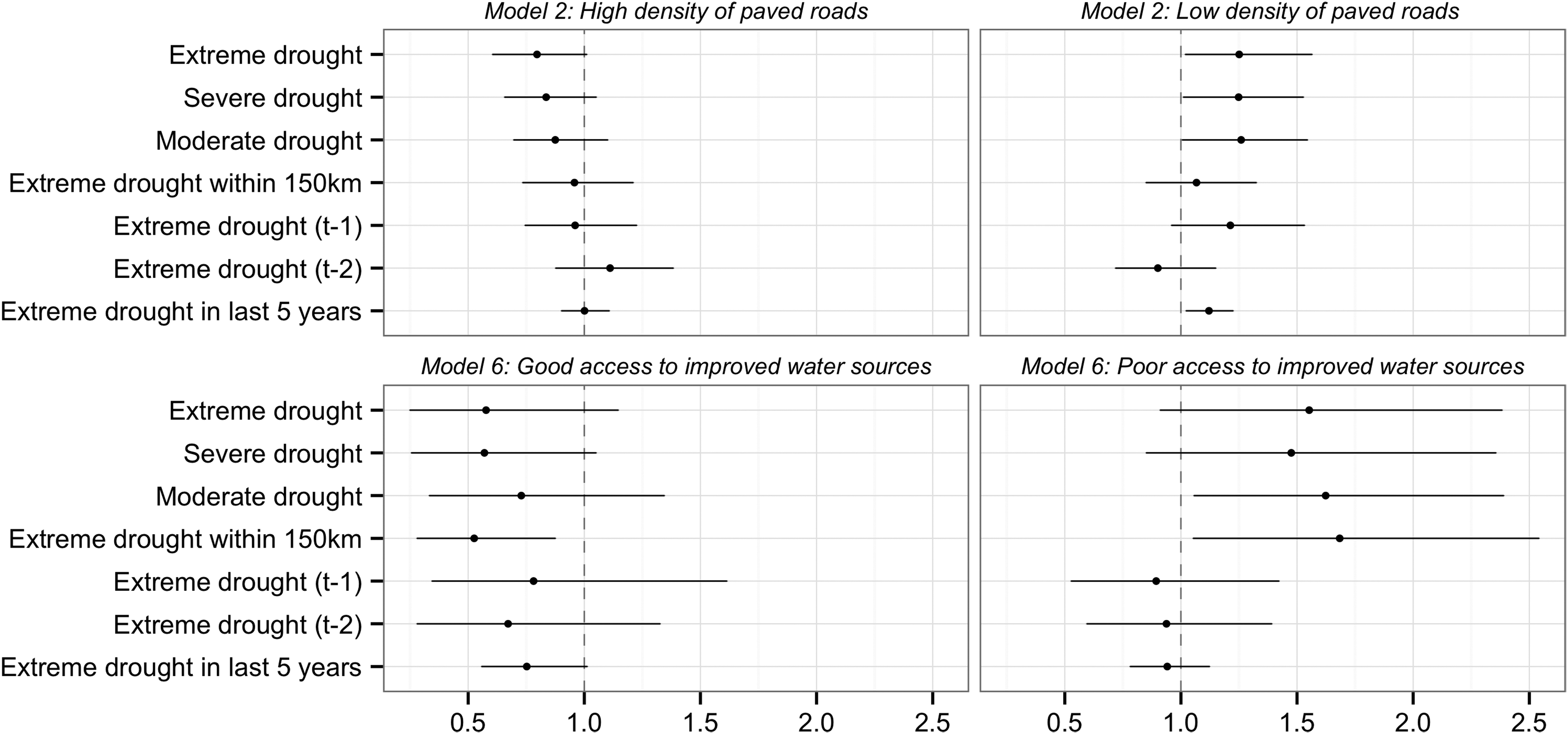
That said, the importance of rainfall shortages as a conflict-facilitating factor should not be overstated. Despite significant results, the overall contribution of drought measures to predicting violent events in sub-Saharan Africa is modest. Owing to data limitations, it is also difficult to assess to what extent the observed data are truly representative of the African context. On one hand, the subsamples utilized in the analysis contain countries as diverse as Mali, Burundi and South Africa, and thus cover a broad range of economic, political and environmental conditions across sub-Saharan Africa. Moreover, descriptive statistics for most variables in the subsamples are very similar to those in the full sample covering all sub-Saharan countries (see Table III, Online appendix). On the other hand, the results presented here might not readily apply to countries that are not included in the analysis. For example, Somalia has been lacking an effective government for most of the observed period, possibly implying a different strategic role of infrastructures from the one assumed in this article, that is, paved roads might have facilitated rather than prevented the operations of rebel groups in Somalia. The results of the analysis should thus be interpreted with some caution.
Moreover, alternative explanations for the observed relationship between droughts, infrastructures and conflict risk could be considered. For instance, the conflict-inducing effect of droughts in regions with low coverage of paved roads could be due to the latter variable picking up topographical features such as rough and inaccessible terrain that facilitates guerrilla warfare (cf. Couttenier & Soubeyran, 2014: 216). Similarly, the higher frequency of drought-related communal conflicts in regions with poorly developed water infrastructures could stem from a generally weak performance of local resource management institutions in these areas, due, for example, to incomplete political reforms and the coexistence of competing resource claims based on statutory and customary law (see Raleigh, 2010; Jaglin, Repussard & Belbéoc’h, 2011; Lund & Boone, 2013). Due to time and data constraints these possibilities are not further explored here. Yet, they could be a good starting point for future investigations of the drought–conflict nexus.
As for policy recommendations, the results of the analysis indicate that better infrastructures reduce the general risk of armed conflict in connection with extreme weather events, suggesting that development efforts in Africa’s drought-prone areas could yield additional benefits in terms of security. Yet, building new roads and drilling new boreholes in politically volatile regions might come with their own challenges. For example, Unruh & Shalaby (2012) demonstrate that road construction in conflict-ridden areas with weakened institutions can facilitate land grabbing by powerful individuals, exacerbate local grievances and open up avenues for rebel groups to extort money from construction companies. Similarly, Krätli & Swift (1999) explain that the drilling of new boreholes in rangelands can generate disputes between pastoralists, as new grazing areas become accessible, for which there are no established use rights. Such and similar challenges need to be accounted for, if infrastructural development is to be used as an effective tool for conflict prevention.
Footnotes
References
Supplementary Material
Please find the following supplemental material available below.
For Open Access articles published under a Creative Commons License, all supplemental material carries the same license as the article it is associated with.
For non-Open Access articles published, all supplemental material carries a non-exclusive license, and permission requests for re-use of supplemental material or any part of supplemental material shall be sent directly to the copyright owner as specified in the copyright notice associated with the article.