



Abstract
Objectives:
Abandoned houses may attract or generate crime; however, little is known about the nature of this relationship. Our study is aimed at better understanding this link.
Methods:
Focusing on a high-crime neighborhood in Ohio, we use spatial video and calls for service (CFS) to examine how crime changed on streets where abandoned homes were removed. We also draw on the insights of 35 ex-offenders, police officers, and residents to examine how and why abandoned houses are connected to crime in this locale.
Results:
On average, streets where abandoned houses were razed accounted for a lower proportion of neighborhood crime after removal. Also, a lower proportion of total CFS from these streets related to serious crime. Our narrative data indicate that abandoned houses are opportunistic because they provide cover, unoccupied spaces, and are easy targets.
Conclusions:
The removal of abandoned housing was associated with positive changes in crime overall; however, our approach revealed interesting variation across streets. We surmise that the relevance of a particular abandoned house may be contingent on the larger context of that street or neighborhood. In order to understand these dynamics, future research should continue to “drill down” into micro-spaces.
Interest in microgeographic variations in crime is growing in criminology, with numerous studies identifying crime “hot spots” and examining the efficacy of interventions in these spaces (Braga, Papachristos, and Hureau 2014; Sherman, Gartin, and Buerger 1989; Weisburd 2015; Weisburd, Groff, and Yang 2012; Weisburd et al. 2004). Yet little research has been aimed at understanding the sources of this microgeographic variation. In particular, aspects of the built environment may be important to consider, given that the appearance or presence of certain structures may shape criminal opportunity and perceptions of neighborhood investment (Weisburd et al. 2012). One aspect of the built environment suggested by prior research is the presence of abandoned housing, which has been associated with crime at the neighborhood level (Boessen and Chamberlain 2017; Branas, Rubin, and Guo 2012; Hannon and Cuddy 2006; Cohen et al. 2003) and microgeographic level (Wheeler, Kim, and Phillips 2018). However, this body of work remains limited in important respects. For one, most studies are aimed at the neighborhood level, and these larger units of analysis may obscure contextual variations across street segments. Moreover, it is at this more local level where the removal or presence of an abandoned house should be most relevant. Second, extant research lacks an in-depth or nuanced understanding of how or why abandoned housing “matters” with respect to crime. While these structures may be crime generators or attractors (Brantingham and Brantingham 1993), they may also lead to crime more indirectly by signaling neighborhood decline (Skogan 1990; Wilson and Kelling 1982).
Our study builds on prior work using a mixed methods approach to examine (1) street-level changes in crime after the removal of abandoned houses and (2) the roles played by abandoned houses in generating or attracting crime. We focus on a neighborhood we refer to as Hope Gardens, which was particularly impacted by the “Moving Ohio Forward” Program, a 2013 initiative providing Ohio 95 million dollars to fund the removal of vacant housing (Western Reserve and Conservancy Thriving Communities Institute 2015). One of the explicit aims of the demolition program was to improve crime and safety, since abandoned houses create “a toxic breeding ground for crime” and are “havens for criminal activity” (Ohio Attorney General, 2015). Indeed, the removal of vacant homes is a common and costly strategy employed to reduce crime, making it especially pertinent to understand this relationship. We “drill down” into the microgeographic context of housing demolitions in Hope Gardens, drawing on spatial video, calls for service (CFS), and narrative data. First, we assess whether streets accounted for a lower percentage of total neighborhood crime after the removal of abandoned housing. Second, we assess whether the types of calls coming from those streets changed. Third, we draw on narrative data with 35 ex-offenders, police, and local residents, who guided us on “ride-alongs” and provided their perceptions and knowledge on local crime dynamics, including the role played by vacant houses. In addition to the practical implications of our study for demolition programs, our study contributes to theory and research in the areas of crime pattern theory (Brantingham and Brantingham 1981), broken windows theory (Skogan 2015; Wilson and Kelling 1982), situational crime prevention (Clarke 1995), and offender decision-making (Wright, Logie, and Decker 1995).
Vacant Housing and Crime
In their formulation of crime pattern theory, Brantingham and Brantingham (1993) distinguish between crime attractors and generators. While crime attractors boast crime reputations or present criminal opportunities (e.g., items to steal), crime generators draw large amounts of people, some of whom may be potential offenders or victims (e.g., stadiums). Following this theoretical reasoning, an abandoned house could attract and/or generate crime. On the one hand, abandoned houses may provide direct, tangible opportunities for crime. They are less likely than other places to “have effective locks and other security measures” and may “reduce costs of crime by increasing the supply of easy theft and victimization opportunities” (MacDonald 2015:359). Skogan (1990) suggests these structures are targets for vandalism and the stripping of copper. Further, Spelman (1993) finds that 83 percent of abandoned buildings in a neighborhood showed evidence of use for various types of crime, including prostitution and drug dealing, but he also argues that abandoned buildings can be used as “staging areas or gathering areas” for crimes committed elsewhere. Teixera (2016) observes in a recent study that youth perceive vacant houses as ideal locations to conceal drug use.
If an abandoned house attracts offenders for the abovementioned reasons, it may generate additional crimes as well. For example, two unassociated individuals may go into an abandoned house separately to use drugs. If they cross paths inside, this could lead to an unexpected altercation. Abandoned housing may also lead to crime more indirectly as well. The presence of dilapidated housing could serve as a cue to potential offenders that residents and police are not invested in the area and that the neighborhood is in decline (Mummolo and Brubaker 2008; Skogan 1990; Wilson and Kelling 1982). Thus, offenders may offend in and around abandoned housing, perceiving these locations to be “fair game” for a range of illicit behavior.
A relatively small literature examines the salience of abandoned housing for crime, consistently finding a positive association between the presence or level of abandoned housing and crime. However, research is somewhat mixed as to whether abandoned housing is relevant for all crimes or only certain types of crime. Consistent with the tenets of situational crime prevention (Clarke 1995), the removal of abandoned housing may only be relevant for the specific criminal opportunities afforded by these structures. For example, Kim (2016) finds that the percentage of occupied homes on a street has a robust negative association with property crimes, but an inconsistent association with violent crimes. Similarly, Raleigh and Galster (2014) find that the proportion of vacant housing units on a street is positively related to burglary and drug crimes, but negatively associated with larceny and unrelated to violent crimes. Boessen and Chamberlain (2017) also find that the presence of abandoned housing is positively correlated with property, but not violent crime. As a departure from these studies, Branas and colleagues (2012) find that increases in vacant housing are associated with increases in aggravated assault and Wheeler et al. (2018) find evidence that demolishing abandoned houses in Buffalo, New York, was associated with reductions for both violent and nonviolent calls at the microgeographic level. However, effects did not consistently hold for census tracts. Wheeler and colleagues (2018) note that their inconsistent findings suggest a need for future research, especially using “measures of citizen perceptions” on whether removing vacant housing is actually connected with greater collective efficacy (p. 418).
We agree that more research is needed on the relationship between abandoned housing and crime. Research to date provides a somewhat limited, inconsistent, and incomplete picture of the dynamics underlying the relationship. Moreover, the use of citizen perceptions to better understand the meanings and connections between abandoned housing and crime is a fruitful direction. In addition, we argue that the perceptions of police and ex-offenders can be especially helpful here. Police are valuable informants about local crime dynamics. Also, little criminological research examines the processes by which offenders choose targets or make decisions about where and when to commit their crimes (Brantingham 2013; Jacobs, Topalli, and Wright 2003; Jacobs and Wright 1999; Wright et al. 1995). This more qualitative approach to understanding offender decision-making is essential to understanding how aspects of the environment, such as abandoned housing, are used in the commission of crime.
In short, our study builds on this area of research by investigating two related questions: How does crime change at the street level after the removal of abandoned housing? and (2) what is the role of abandoned houses in generating or attracting crime? Given prior theory and research, we expect that streets where abandoned housing is torn down will account for a lower portion of total neighborhood crime and that a lower portion of CFS from those streets will pertain to serious crime. Based on prior research, we also expect that the removal of vacant properties may be more relevant for property versus violent crime. This is a possibility we explore both through our qualitative and quantitative data.
1
Study Site
We focus our study on a high-crime neighborhood, “Hope Gardens,” which is located in a midsized Ohio city that had a violent crime rate nearly triple that of the national level and a property crime rate twice as high in 2012 (Uniform Crime Reports). 2 Our research was carried out in cooperation with the local police department, who wanted to learn more about crime hot spots. Hope Gardens had a crime rate almost double the city rate. It is also the most diverse and youngest neighborhood in the city. As of 2000 decennial census, the neighborhood was 43 percent Black and 78 percent of all residents were under the age of 45. About 37 percent of residents were living in poverty and 40 percent of residents who were 25 years or older had not completed high school. As of 2015, 39 percent of the lots in Hope Gardens were vacant, giving the neighborhood a “checkered” appearance (Western Reserve Land Conservancy Thriving Communities Institute 2015). The neighborhood also has the highest percentage (10 percent) of abandoned properties in the city (Western Reserve Land Conservancy Thriving Communities Institute 2015). Some of our participants referred to Hope Gardens as a “forgotten” neighborhood, feeling as though people were moving out of the neighborhood in droves and that resources to revitalize the community were lacking. However, the neighborhood is home to seven community gardens—an effort among local outreach programs to convert vacant lots into positive spaces for residents. Hope Gardens is bordered on one side by a lake and on two other sides by a highway or industrial and commercial properties. These provide clear neighborhood boundaries and were consistent with those identified by participants. Thus, we use them to approximate our study area.
Data
Spatial Video
We use spatial video technology to observe changes in the built environment in Hope Gardens from April 2014 to August 2015. Spatial video methodology has its roots in geography (Curtis et al. 2015) and was originally developed to aid in the rescue and recovery response to Hurricane Katrina (Curtis et al. 2007). It is an efficient and affordable means of collecting spatially encoded high-definition video, which can be used to code the physical environment. The method involves the use of “Contour Plus 2” cameras, which are designed for extreme sports and fitted with an internal GPS unit. The cameras also permit video to be collected at high speeds, unlike the use of older video camera technology (Sampson and Raudenbush 1999). We attach these cameras to car windows (two on each side in case one camera loses power or GPS connection). They are placed on the inside of the car using window mounts and are small (approximately four inches long), reducing the possibility that people on the street can see the devices. Approximately every three months we collected a complete visual map of Hope Gardens by driving along each street and collecting video (six waves). The decision to collect data at three-month intervals was based on available resources and time, but also to observe changes across seasons. We viewed the data collected using free Contour Storyteller 3.6.2 software, from which we matched images with exact locations on an accompanying map. We then digitized information, such as the removal of an abandoned house, into ArcGIS 10.3.
CFS
We analyze changes in CFS data, which include 911 calls as well as calls to nonemergency police lines and police-initiated encounters. We use CFS because these data capture disturbances in addition to emergencies. Thus, we are able to gain a more comprehensive picture of illicit activity in the neighborhood (Weisburd et al. 2004). While the completeness of CFS data may vary (Klinger and Bridges 1997), the focus on smaller units such as street segments is thought to reduce errors from miscoding of data (Weisburd 2015). We differentiate calls related to violent and property crimes as well, since we predict that the removal of a vacant house should be more impactful for property crime.
Geonarratives
We carried out 35 ride-alongs with ex-offenders, police, and residents to collect geonarratives—environmentally cued narratives where place is used to stimulate discussion about fine-scale neighborhood characteristics (see Curtis et al. 2016). This is a simple yet powerful tool to collect perceptions and experiences of places. Geonarratives have been used to understand environmental contexts for outcomes such as health, crime, and postdisaster recovery (Curtis et al. 2015). As Curtis and colleagues (2015:22) note, “the need for personal context is compelling,” given that local knowledge may be essential to understanding relationships between people and places. Moreover, asking individuals to comment on an environment without being situated within that environment may yield less reliable or valid data. For example, cognitive mapping typically requires participants to identify places on a map that are meaningful to the research (e.g., “unsafe” places). However, maps may be confounded by factors such as spatial memory, familiarity with street names, or even the size and shape of the map provided (Pocock 1976). Placing an individual in the environment of interest and capturing “on the ground” reactions to places should thus produce more valid and reliable information.
In our study, participants provided comments about Hope Gardens while guiding two members of the research team through the area. These ride-alongs lasted generally 1 to 1.5 hours. Participants were instructed to provide open-ended comments about the neighborhood (specific to crime) while moving through the environment. Each route taken was influenced by what the participant felt was important for us to see, since the intention was to learn what was problematic or criminogenic about the neighborhood from their perspectives.
We used a mixture of nonrandom sampling strategies to recruit our participants. Police participants were selected based on their working relationship with Hope Gardens and were paid overtime by their department to participate. We recruited ex-offenders from local reentry support groups and meetings, where ex-offenders obtain information about employment, education, legal, or health concerns. We also employed purposive sampling by giving preference to ex-offenders and police officers over community members, since their insights may be more germane to understanding crime dynamics. Although the insights of community members may be equally valuable for understanding where crime occurs, police and ex-offenders should know more about the “why” and the “what” with respect to abandoned houses. We located community members through a popular local ministry and café, where a diverse crowd of individuals eat, socialize, hold local business meetings, and attend services. With community members and ex-offenders, we also used snowball sampling and met future participants through past participants. Community members and ex-offenders were provided a US$20 gift card to Family Dollar in exchange for their participation.
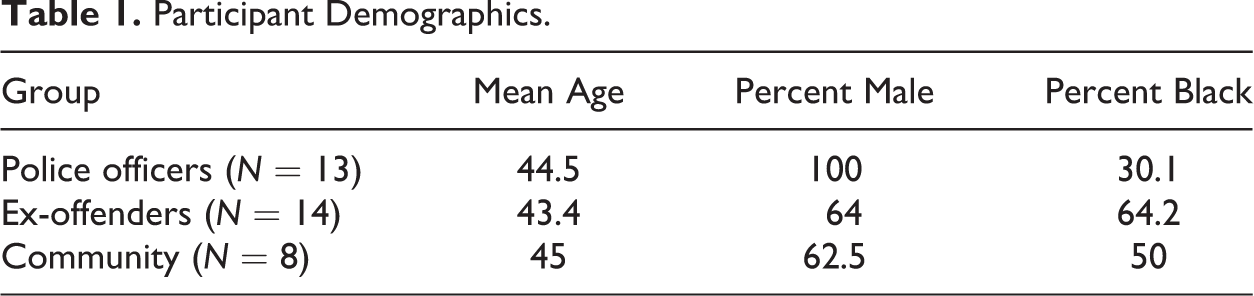
Table 1 shows demographic characteristics for our participants. There is a fair amount of variation across groups in terms of race and sex. Police officers were all male and mostly White. These demographics mirror the sampling frame for the city police department, which is only 10 percent female and mostly White (81 percent). On the other hand, our sample for community members and ex-offenders is more diverse. Notably, we only had one participant who did not identify as non-Hispanic Black or non-Hispanic White. This was a Hispanic male ex-offender.
Participant Demographics.
Analytic Strategy
To investigate our first research question, the locations of all cleared lots from the August 2015 spatial video collection were compared to all other spatial video collected for the neighborhood. “New” clearances were then mapped at each wave. A total of 23 houses on 18 streets were torn down. We created 25-meter block face buffers extending around the street segment on which the house sat. If the house was on a corner, both the facing and side segments were buffered together and counted as one. Figure 1 shows “treatment” buffers (streets where houses were razed during our study period) and crime as of April 2014.

Buffers for analysis and calls for service hot spots in April 2014.
Using our spatial video data, we marked the first wave where a house was no longer observed as the beginning of the “posttest” period for that street. Pretest and posttest periods vary across the 18 streets depending on when a house was removed. 3 Thus, rather than crime being observed for all street segments at one point in time (e.g., April 2014) and then again after 17 months (e.g., September 2015), our approach takes into account the timing of demolitions. For example, Figure 2 shows three hypothetical houses observed over our six time points. House A is standing at each wave. Houses B and C are torn down at different points during our study. For house B, the pretest would consist of waves 1 to 3 and the posttest of waves 4 to 6. Alternatively, house C was removed between time points 4 and 5, meaning the pretest would consist of waves 1 to 4 and the posttest of waves 5 and 6.
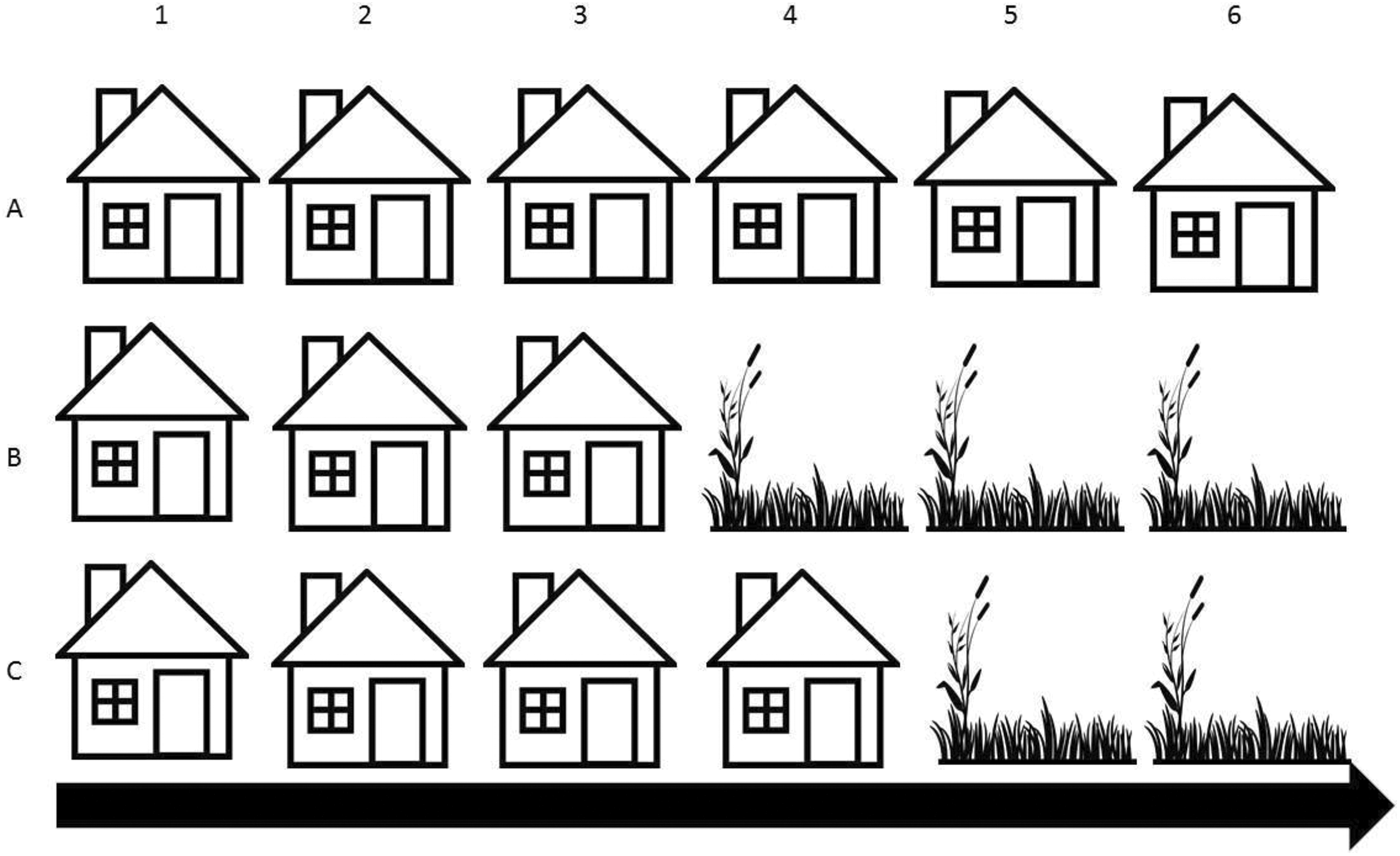
Observations of houses.
Of course, some houses in our study were torn down between the same waves. Specifically, two houses were torn down between waves 1 and 2 (spring 2014), two more between waves 2 and 3 (summer 2014), eight were torn down between waves 3 and 4 (fall 2014), another five were demolished between waves 4 and 5 (winter 2015), and one more between waves 5 and 6 (spring 2015). Essentially, this gives us five pre- and posttest periods across streets. We use these groupings to present changes graphically. First, we examine whether treatment buffers (i.e., streets where houses were torn down) accounted for a lower portion of total neighborhood crime after houses were razed. To be clear, this is an analysis of changes in distribution, not number of incidents. We use this approach because (1) our microgeographic lens is focused on whether crime moved away from these streets rather than if crime in general reduced and (2) analyzing overall levels would be more problematic considering differing times of exposure and seasonal changes across our study. For example, for a street where a house was torn down in fall 2014, we may observe that CFS reduced. However, this reduction could be due to the winter time period immediately following demolition.
We calculate the proportion of neighborhood crime on streets as shown by equation (1), where subscript i represents a group of street segments that had houses removed at the same time and j denotes the time period. The denominator represents total CFS for the neighborhood for that same time period. We expect that street segments will account for a lower portion of total crime in the neighborhood after the removal of abandoned homes.

Rather than using all CFS in the equation above, we only calculate the portion of serious crime calls including property, violent, and drug crimes. In other words, we are interested in the proportion of crime-related calls originating from these streets rather than calls for more minor matters such as stray animals, suspicious persons, and traffic violations. In addition, we do not include calls related to more “social disorder” types of items including calls for drunk and disorderly and loitering (Sampson and Raudenbush 1999).
Our second phase of quantitative analysis is limited to the treatment buffers themselves. For this analysis, we compute changes in the proportion of total CFS on each street that related to serious crime (using abovementioned crime types). For example, for house B in Figure 2, we would compare the proportion of CFS related to serious crime from that street during time points 1 to 3 to the proportion of CFS related to serious crime from that street during time points 4 to 6. Further, we present these results for violent and property crime separately since we anticipate greater changes for property relative to violent crimes after houses are removed. For example, equation (2) shows how this would be calculated for the proportion of calls related to violent crime.

As before, we sum CFS across streets that had the same cut point for pre- and posttest periods. However, there is interesting variation within these groups that we explore these as well. We also draw on our spatial video and geonarrative data to better understand some of the patterns we observe in our quantitative data.
Notably, our quantitative analytic strategy presents both advantages and limitations. 4 Houses were not randomly selected for demolition, and we do not use a random sample of houses, limiting our ability to make causal inferences or to generalize results. Houses torn down were condemned properties which had already been ordered demolished prior to Moving Ohio Forward. They were condemned through a variety of means—including neighbor complaints, police reports, or housing inspections. Once a house was condemned, it was reviewed by the housing appeals board of the city and typically recommended for demolition. The Moving Ohio Forward Program first targeted houses that had been condemned for longer periods of time. However, a house may be moved to the front of the line if it presented a safety or health threat to the community, such as in the case of a fire. As noted, we also observe the total number of houses that were razed in our study area. This raises questions about the use of inferential statistics to interpret our findings, since we are not working with a sample, let alone a random sample. Therefore, all of our findings should be interpreted as descriptive and not generalizable.
To investigate our second research question, we analyze geonarrative data. Narratives were recorded using an audio digital recorder and then transcribed using Express Scribe 7.01 software. Coding and ride-alongs were an iterative process. It became apparent early in the study that abandoned houses were an area of concern for many of our participants. Therefore, we started asking participants who raised the issue of abandoned housing follow-up questions such as “What do you think about abandoned houses?” and “Why do you think they are a problem?” After all rides and transcriptions were completed, each transcription was read in its entirety to identify excerpts about abandoned housing. We also used open-coding to identify emerging themes within this category related to why vacant houses were perceived as problematic. Word searches in NVivo 10 were carried out for “abandoned” and “vacant” as well to be certain no references were overlooked. Abandoned houses were identified as problematic by all but two participants who simply did not comment on abandoned houses. On average, the amount of text related to vacant housing across interviews was 14 percent. Other than the general issue of drugs in the neighborhood, abandoned housing was the most consistent concern raised by our participants.
Housing Demolitions and Crime Change
We first investigate whether there were changes in the percentage of neighborhood crimes originating from street segments where houses were torn down (“treatment” buffers). Figure 3 shows changes across four groups of street segments depending on the timing of housing demolitions. The vertical line cutting through each trend line marks the period when houses were torn down. Notably, we do not show changes for the street where an abandoned house was removed during summer 2015 because this street yielded zero CFS in the three months before and after the house was removed. In total, the street produced nine calls for serious crime between April 2014 and April 2015, but none thereafter during our study period.
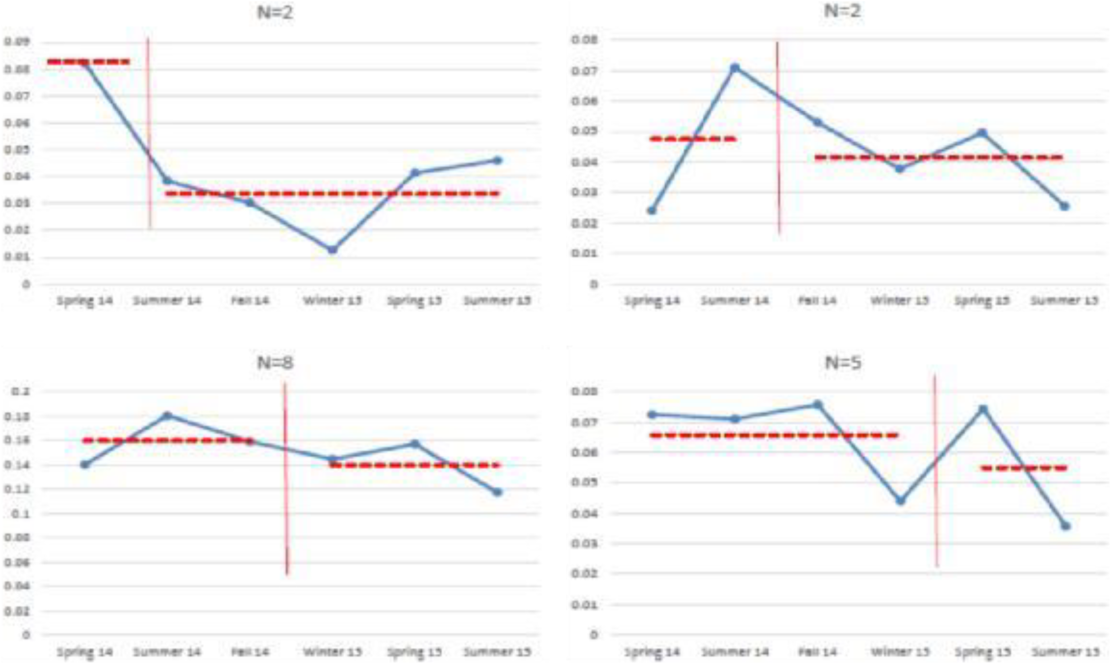
Changes in the percentage of neighborhood calls from “treatment” buffers. Vertical cut point represents when abandoned houses were torn down.
As shown in Figure 3, each group of streets experienced a reduction in the proportion of neighborhood calls for serious crime. The dotted lines across graphs indicate the average proportions for pretest and posttest periods, showing that each group experienced a reduction, although notably these changes are rather small. Taken together, the average change across all streets in the proportion of neighborhood calls was 0.5 percent. In other words, after houses were torn down, each street accounted for 0.5 percent less neighborhood crime, on average, than when the houses were standing.
There is also interesting variation across individual streets. Taken individually, two thirds of streets experienced a decrease in the percentage of neighborhood calls originating from them after a house was demolished and the remaining one third experienced slight increases. The largest reductions across streets were by 3.4 and 2.7 percent, respectively. In the latter case, the reduction was observable across all types of crime observed (violent, drugs, and property). In the former case, the reduction is attributable to violent crime specifically, which changed from 8.9 to 1.8 percent. This street had a house torn down relatively early in the study compared to other cases (by July 2014), meaning the pretest observation was much shorter than the posttest. Consequently, the denominator is understandably smaller in the pretest than in the posttest (225 vs. 804). This raises some concern, since a smaller denominator would give more weight to crime occurring during that period. Looking more in-depth at this locale, there were 13 CFS during the 3-month pretest (mostly violent) and 19 calls in the 15 months afterward (mostly property). Indeed, in the three months prior to the house being removed there were eight calls for violent crime, and only five calls after the house was removed during the following 15 months. Therefore, regardless of the shifting denominators, this seems to be a notable change in criminal activity on this street.
We draw on our spatial video and geonarrative data to better understand the context of this street. First, we observe that 31 percent of lots on this street were vacant and 15 percent of houses were abandoned at the start of our study. In essence, this equates to 12 vacant lots, 4 abandoned houses, and 23 occupied dwellings. While the percentage of housing that is abandoned is equal to the average across our study buffers, the percentage of lots that are vacant is actually lower than the average (48 percent). This raises an interesting possibility. One reason a street may produce relatively more calls than others could relate to the percentage or presence of occupied housing. Similar to the old adage, “if a tree falls but no one is around to hear it…,” if no one is present to observe a crime, a crime may not be reported. In addition, a unique feature of this street is that it is the only one in our sample with a community garden. Thus, perhaps there were rejuvenation efforts on this street that contributed to the positive changes observed. For example, one community member remarked that he believed the community gardens in the neighborhood give “a little bit of a sense of connection and community” and an ex-offender commented that he believed the gardens send a “positive message, like everybody in the community, can get out and help and garden, and that will feed the community.”
We call attention to two streets which experienced slight increases as well. Two adjacent buffers accounted for 2.8 and 5 percent of neighborhood crime before abandoned housing was razed. Afterward, they experienced increases of 0.4 and 0.2 percent. To be sure, these are relatively small changes, but we look more in-depth at these streets because they did not experience the anticipated decrease. In examining our spatial and narrative data, we observe that these streets are located across from an affordable housing apartment complex that was perceived by participants to be problematic. As one officer relayed, “We get some drug activity running in and out of there. We get a lot of fights, a lot of alcohol infused fights in this particular complex.” There is also a convenience store on the connecting street which draws a lot of foot traffic. One possibility is that the removal of vacant housing in this case may have facilitated travel to and from the store and may have provided more open space for residents to interact. 5 Figure 4 shows one of the abandoned houses before its removal and a zoomed-in map of this area. The abandoned house shown is located on the west side of the map directly across the street from the affordable housing complex.

Microgeographic context of crime hot spot, 2014.
Moving to the second phase of our quantitative analysis, Figure 5 shows how the nature of calls within treatment buffers changed after the removal of abandoned houses. Among the calls originating from these streets, we investigate whether there was a shift in the types of calls. In general, we find that the percentage of calls related to serious crime decreased across groups after abandoned housing was razed. The average reduction across segments was 7 percent. In other words, among calls originating from these streets, there was an average reduction of 7 percent in the proportion of calls that related to serious crimes such as property, drug, and violent offenses.
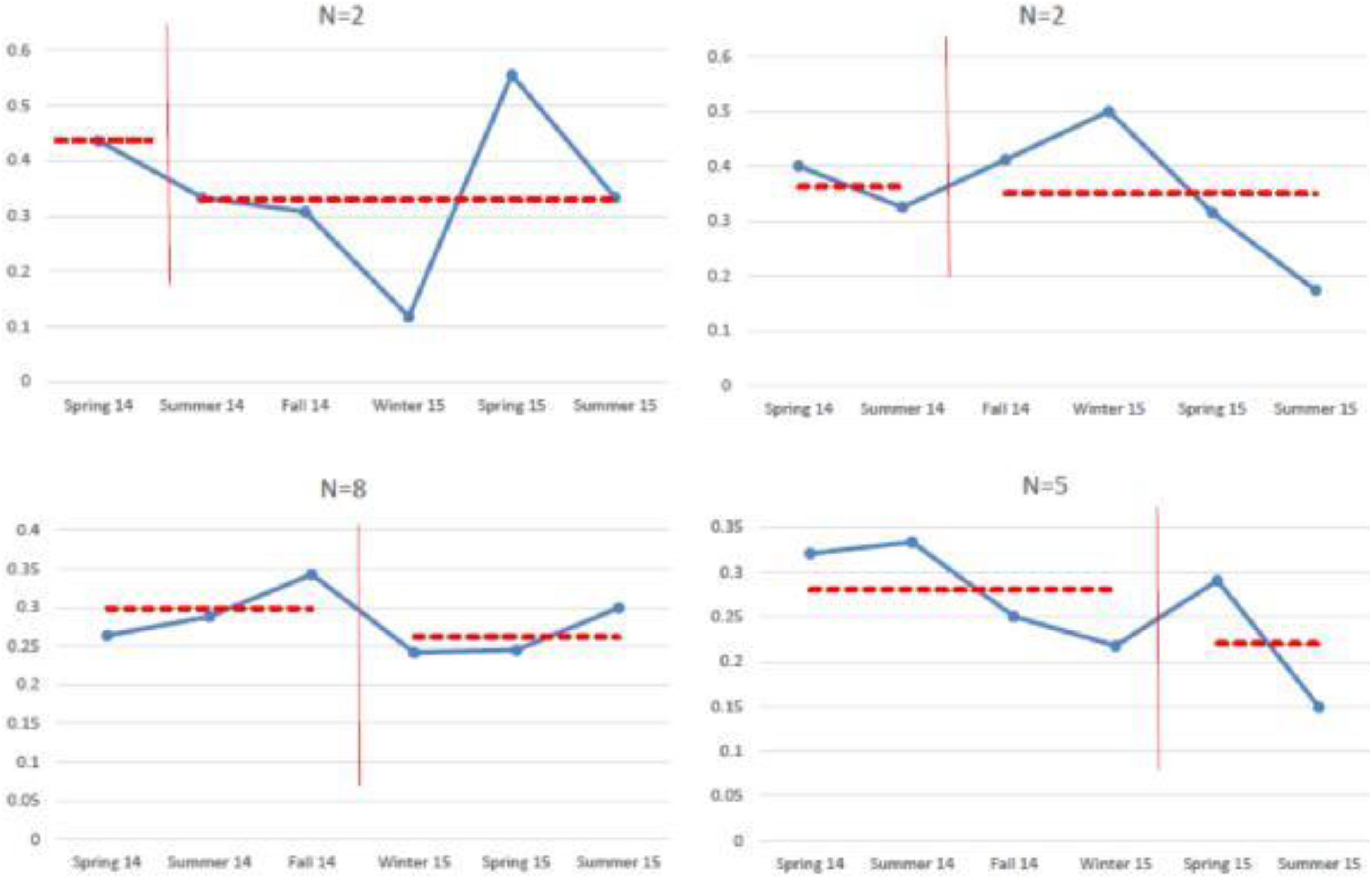
Changes in the percentage of calls from “treatment” buffers related to serious crime.
As with our first set of findings, there is some variation across buffers, with four experiencing increases in the proportion of calls related to serious crimes. However, the modal experience was a decrease, and we focus on one buffer in particular, which experienced the largest decrease (57 percent to 33 percent). As shown in Figure 6, this street has a liquor store on the one end and a car wash on the other. These were known crime generators or attractors in the area according to our participants, who commonly remarked on the problem of men loitering outside of the liquor store. This car wash was also suspected by police to be a front for drug activity. One police officer explains, “We would see a lot of people coming and going from there. But when you have a business, especially a car wash where that’s kind of what you see, it’s hard to get a handle of what was going on there.” A resident confirmed to us that this car wash was in fact a hub for drug sales, stating, “People with legitimate [reasons] coming in and out kind of is a smoke screen for whatever else that goes on behind the scenes, and there’s some drug dealing because the people who run those little independent car washes like that, they can make more money selling drugs.”
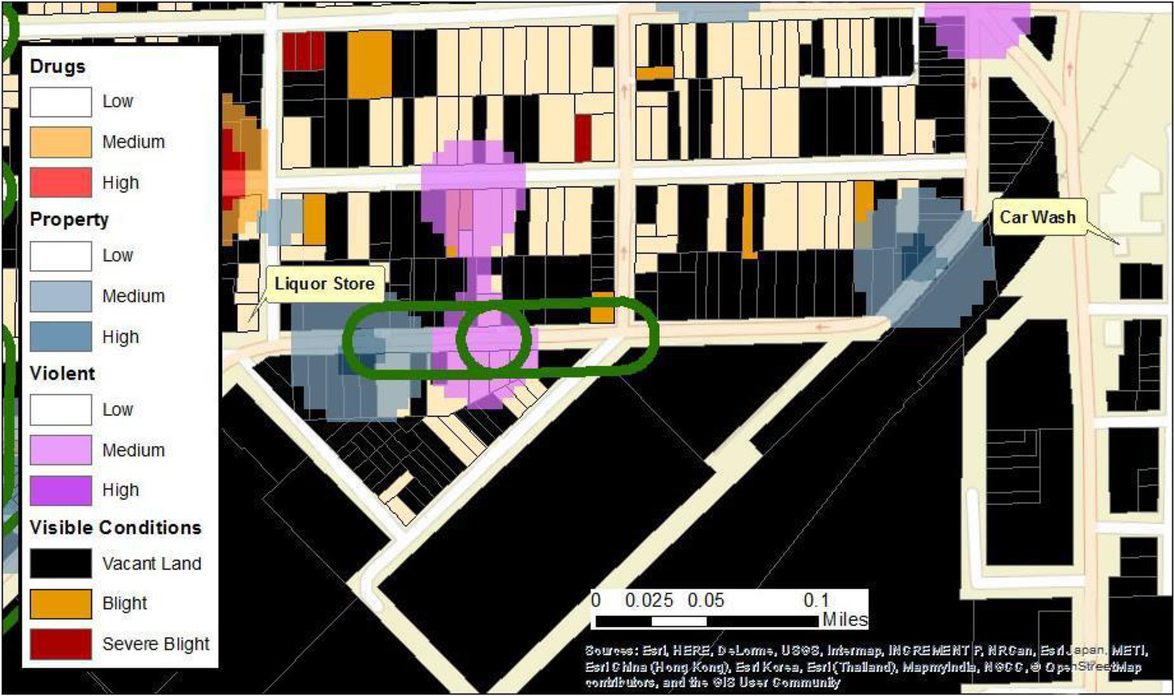
Street with largest reduction in percentage of serious calls, 2014.
Similar to the ideas of Spelman (1993), who noted that abandoned houses may be used as staging areas for other crimes, we argue that in order to understand the influence of abandoned housing, scholars should consider the surrounding environment as well (see also Branas et al. 2012). Indeed, the presence of abandoned housing alone may not be as criminogenic as abandoned housing located nearby other attractors and generators such as this liquor store and car wash. For example, people may buy drugs at the liquor store or the car wash and then use the drugs in nearby abandoned housing. By demolishing that house, associated crime may be reduced or pushed elsewhere. Another aspect of the environment we note in this figure is the sheer amount of vacant land. To be sure, Hope Gardens may be a unique context in which to study the relationship between housing demolitions and crime. A large portion of the neighborhood is empty—either represented by vacant housing or lots—which may affect crime patterns we observe.
Finally, Figure 7 illustrates changes in the proportion of calls related to property and violent crime specifically. When observing these crimes separately, it does not provide a clear picture of whether reductions are more pronounced for violent or property crime, respectively. The proportion of calls related to violence decreased for streets where houses were torn down in spring 2014 or winter 2015. Alternatively, streets where houses were torn down in summer 2014 or fall 2014 experienced no discernible decline. Similarly, the results for property crime are inconsistent. We thus conclude that we do not observe any evidence of changes being crime-specific. While some of these patterns may be seasonal, our study is also not suited to investigate that possibility. 6
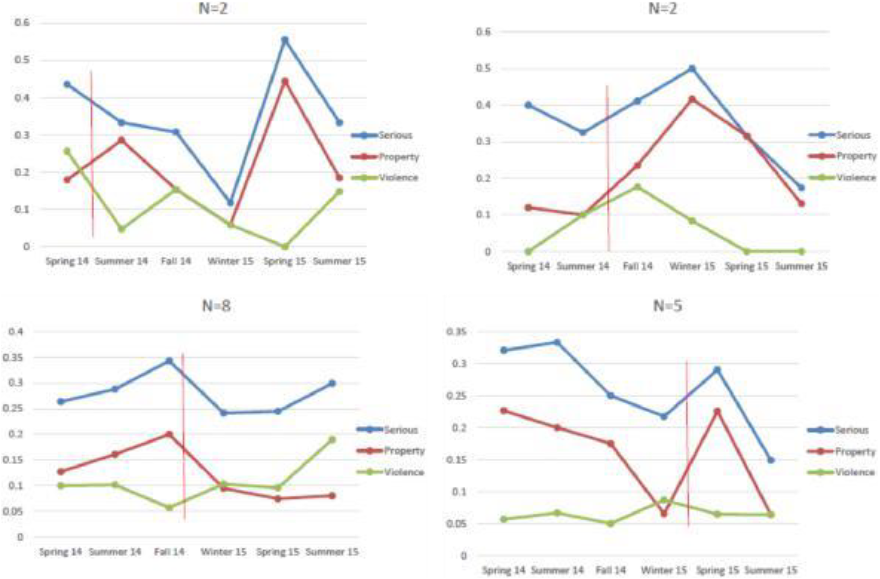
Changes in the percentage of calls from “treatment” buffers related to serious crime, property crime, and violent crime.
Up to this point, we have provided a descriptive account of crime change following housing demolitions in Hope Gardens. On average, we find that the percentage of neighborhood crime attributable to each buffer where a house was torn down decreased. Additionally, we find that a lower percentage of calls originating from these streets pertained to serious crimes. In the following section, we turn more squarely to our narratives to explore the ways in which abandoned housing is connected to crime in Hope Gardens.
Insights from Ex-offenders, Police, and Residents
Before delving into the different criminogenic roles played by vacant housing in Hope Gardens, we highlight a seeming contradiction between our call data and interview data regarding drug crime. As suggested by prior theory and research, the presence of abandoned housing may be especially pertinent for drug activity since offenders may use the houses to use or deal drugs. However, there were no drug calls in 72 percent of our observations across streets, which mirrors the larger tendency in the neighborhood. Due to the rarity of calls pertaining to drug dealing or drug use, we were not able to assess changes over time in these crimes, but our geonarratives suggest that drugs are perceived as a pervasive issue in Hope Gardens and that abandoned housing plays an instrumental role in drug activity. We use our geonarratives to help to contextualize this contradiction between our data sources.
In short, participants commented that residents are reluctant to call the police sometimes. As one community member told us, he would only call the police if “it’s something real, real bad,” and another resident said he would call the police in the case of a missing child or “if I see somebody being beat up.” Reasons related to impressions that response time was slow or that the police “are just not fair.” One ex-offender noted that he had called the police a couple of times in the past when witnessing violent fights but stopped calling because “you call the police—by the time they come, they done beat the brakes off the dude.” In fact, one former burglar told us that he did not worry about alarms for this reason. As he stated, “That’s why we don’t care about alarms. We feel like, you know, police don’t care.” In this ex-offender’s case, he actually hid nearby and watched how long it took police to arrive after he burglarized a house with an alarm. Seeing that more than 30 minutes lapsed before police were on the scene, he chose to burglarize that house again and to spend more time inside gathering items. In short, perceiving that police response is inadequate may lead residents to tolerate certain types of crime and report more serious crimes, like violence.
Aside from drugs, the issue of abandoned housing was the most frequently raised concern among participants. In fact, these issues were often raised in tandem, since abandoned houses were frequently identified as former drug houses. For example, the following excerpt with a police officer shows a typical reaction as we would drive down a street with abandoned housing: Yes, here, here, here (pointing left and right) all used to be drug houses. Yes, I mean all this vacant stuff all used to be drug houses. You know, unfortunately like this house back here…oh not this one, next one. That was a crack house. Right there, we did a search warrant on that [house]. Right here all the way back there. Um 10–12 years ago and it’s just like it is after we left it. I mean we kicked everybody out and they haven’t done anything with it. It’s easy to rent a raggedy house through here and make it a dope house, and you know um, that would be the house where they would sell drugs out of, you know, that’s what they would do in all of the, you know, crack heads or whatever will go there and buy they dope and then that’s how they would do it until you know the police figure out that that house is no good. Then they might want to go in there and you know raid the house and shut the house down. We’ve had people dealing dope out of vacant houses, making meth labs out of vacant houses. The prostitution in the houses actually involving juveniles. The vacant houses attract everything—kind of like the corner stores. It’s a free for all.
Hiding Spots
Abandoned houses can be used as cover for criminals, criminal activity, or evidence. For example, an ex-offender in our sample used abandoned houses to hide after committing robberies. As he describes, The stores that I would select, especially the one in this area, there was abandoned houses and I knew that…I knew that I could actually go into an abandoned house and not get caught and that’s exactly what had happened.
He would then wait until the police left, change into a spare set of clothes he planted at the house beforehand and leave. Although it was the assumption of this ex-offender that police would not think to check abandoned houses, the tendency for houses to be used in this way was not lost on the police: They can hide there, if we’re running after someone, they turn and they bail, it’s a vacant house but we didn’t know they went in there. We were going in there to get high, and especially contingent upon what the weather conditions are, that would make a difference too, whether you would find somebody in there or not. Some people sleep in those kind of places, some people use them to get high in, some people use them to turn tricks.
Importantly, the attractiveness of abandoned houses as hiding spots creates dangerous environments inside them. Abandoned houses were recognized as dangerous by most participants across groups due to the tendency for such houses to catch on fire, contain materials hazardous to children, or to become places of victimization. For example, one ex-offender recounts, You had young girls getting raped in these homes, you had um, teenage boys and girls having sex in these homes, drug dealing was in these homes. Um if they go into a home and the lights just happen to be on…they, it’s a party house now but nobody is supposed to be there, it’s dangerous to have something like that. We’ve walked into vacant houses and you’ll find the drugs, the baggies left over or crack pipes, meth pipes, condoms…you know, anything. All the kids call the vacant houses “bandos” for abandon. When they do a burglary sometimes they’ll actually hide the stolen property in an abandoned house until they get transportation to move it. Personally I think there’s a lot of drugs being moved from vacant home to vacant home.
Unoccupied Spaces
Abandoned houses provide a neutral and convenient location for people to meet and for homeless people to take refuge. Criminals may choose to meet or engage in criminal behavior in an abandoned house because it is available (attractor), but crimes may also arise because potential criminals and potential victims spend time in abandoned homes (generator).
For example, participants spoke of “squatters” and “homeless” people (“a lot of squatting, a lot of homeless people will go in and squat there”). Abandoned homes were also places where homeless persons, squatters, and “drug addicts” simply go to sleep (e.g., “abandoned houses, now that’s what keeps the crime up too. You know, the drug addicts breaks in em and sleeps in em”). This was especially seen as the case during the winter, when “people are more desperate.” One ex-offender described sleeping in them himself during the winter (“I mean when it gets cold, what are you going to do…you know what I mean?”). This particular ex-offender spent a period of time homeless and using drugs. He slept inside vacant houses because they were available spaces where he could sleep or take shelter from outside elements.
Participants also explained that kids use the houses just to “hang out” or “play.” For example, one officer remarked that “a lot of the kids just look at it as another yard to play in.” Another officer described them as popular hangout spots for kids skipping school: You get kids breaking into them because they want to hang out in them…we always have the older kids who go in the vacant houses, and they set up and spend the day there from school.
While there is some overlap between these opportunities afforded by abandoned houses, it is valuable to consider them separately. There are reasons that individuals may venture into abandoned houses that are unrelated to the need to hide their activity—such as a homeless person sleeping or teenagers hanging out. However, the availability of these spaces may put these individuals at risk of being victimized by offenders who are using the space to hide their criminal activity. Thus, the elimination of these structures has implications for eliminating risk among potential victims and for eliminating opportunities for concealment on the part of offenders.
Targets
Finally, in Hope Gardens abandoned houses were identified as targets for theft and vandalism. One community member noted that offenders would “take the central air unit out of them” or “just throw rocks through the windows.” Another resident expressed frustration and disappointment at youth for vandalizing these buildings, believing they did not understand the long-term consequences of their actions. As he explained, It’s just a way for kids and young adults to be destructive, you know, but they don’t understand the destruction still stay in our neighborhood, you know?
Cohen and Felson (1979) argue that an item, place, or person is more likely to be targeted if an offender perceives potential rewards associated with the target, if it is easy to move or manipulate, if the offender can easily see the target, and if it is easy to access. Put simply, offenders are more likely to target relatively easy and/or profitable items, places, or people (see also Wright and Decker 1994). Abandoned housing may therefore be an easy target, given the lack of guardianship and the relative ease with which offenders can access them. Abandoned housing is ideally boarded up to help prevent entrance, but these measures may not be effective. As noted by one former offender and a police officer: Look at all that, there’s a bando there, motherfuckers go in there and smoke crack and they done boarded it up 20 times already. They board up the doors and windows. That works for a while but you know, any fool with a sledgehammer, or a-not a sledgehammer, a crowbar, a screwdriver, can get right back into it.
In sum, our narratives suggest that offenders are attracted to abandoned houses because they offer opportunities such as concealment and accessibility. They are also unoccupied, making them “available” spaces for a range of crimes. Moreover, the qualities that make abandoned houses crime attractors may also lead them to become crime generators, since they are places where potential victims and offenders converge. In our discussion, we further expand upon the implications of our findings and offer suggestions for future research.
Discussion
In this study, we provide a descriptive exploration of a housing demolition program in a high-crime neighborhood in Ohio. We find that streets where abandoned houses were removed accounted for a lower portion of neighborhood crime after removal and that the nature of calls changed, with a lower portion of calls pertaining to serious crime. Our findings are generally supportive of prior work finding a link between abandoned housing and crime; however, our results should be interpreted as descriptive rather than as evidence of this particular demolition program being an effective crime control strategy. We also examined whether changes were specific to certain types of crimes, but we do not find evidence supporting this possibility. Additionally, we draw attention to the variation we observed across streets where abandoned housing was razed. In particular, a handful of streets became more crime-saturated after a house was razed or experienced slight increases in the proportion of calls related to serious crime. Looking more in-depth at the microgeographic contexts of our buffer areas, we surmise that changes spurred by housing demolitions may be contingent on the surrounding environment. For example, the proximity of other crime attractors may be relevant, as may the percentage of occupied residences or the proximity of potentially protective places such as churches and community gardens. Future research should continue to drill down into these spaces, examining how interactions between places and the larger neighborhood context shape crime patterns.
Our narratives also help to contextualize our quantitative findings. For example, taking CFS data at face value we may have concluded that drug crimes are relatively rare in Hope Gardens. However, drugs were the most common issue discussed by participants. The rarity of calls may be due to residents’ reluctance to call the police in certain situations. Our participants reported that slow response times dissuaded them from calling the police unless crimes were perceived as “serious,” such as in the case of violence. Investigating the nature of call data is an interesting avenue for future research. While calls are often considered the most valid and unfiltered source of crime data across geographic areas (Warner and Pierce 1993), they still suffer from measurement error. Future research should further explore the factors which influence crime reporting with more of a lens on context rather than individual characteristics.
Our narratives also reveal important insights into how abandoned housing is connected to crime in Hope Gardens. Specifically, three main themes emerged across participants, which were that abandoned houses are connected to crime as hiding spots, available spaces, and as targets. Notably, our qualitative results align more with crime pattern theory (Brantingham and Brantingham 1993) and routine activities theory (Cohen and Felson 1979) than with broken windows theory (Wilson and Kelling 1982). Our participants explained that abandoned houses are problematic for crime because they represent tangible and direct opportunities than because they signal neighborhood decline. Similar to qualitative work on burglary decision-making (Rengert and Wasilchick 2000; Wright and Decker 1994), participants noted that abandoned houses were attractive because of factors related to opportunity; they are easy targets, relatively accessible, lack guardianship, and provide concealment. Perceived criminal opportunities also ranged across many offense types, including prostitution, robbery, burglary, drug use, sexual assault, and even homicide (as described by one of our police officers, they are a “free for all”).
Our work also contributes to qualitative work on offender decision-making. As noted by Brantingham (2013), “remarkably few criminologists have actually asked offenders how they find targets” (p. 548). Indeed, a few of our ex-offender participants reported being strategic in their use or selection of abandoned houses—picking ones that met a specific set of criteria (e.g., isolation and foot traffic). This comports with prior work showing that some offenders engage in rational and deliberate decision-making processes in the commission of their crimes (Deslauriers-Varin and Beauregard 2010; Jacobs and Miller 1998). For example, Wright and Decker (1994) find that many burglars in their sample choose targets based on the perceived worth of possessions inside the residence, but also weighted that possible gain against perceptions of risk, as signaled by factors such as alarm systems, guard dogs, and familiarity with the neighborhood. Importantly, studying the ways in which abandoned housing is used by offenders also offers unique insights since these structures are not as often selected because of their attractiveness as “targets” per se. Rather, offenders in our sample used these structures more often as instruments than as targets. Abandoned houses can be used as escape havens following a crime, as a space to conduct or plan criminal activity, or as a place to hide criminally obtained materials. Thus, future research should continue to explore offender decision-making with qualitative approaches that take into account target search as well as other ways offenders interact with their built environments to commit crime.
Also consistent with crime pattern theory and routine activities theory, abandoned houses were perceived as crime generators. While offenders may be attracted to abandoned houses, abandoned houses are also spaces where potential victims and motivated offenders are likely to converge in space and time and without guardianship. Thus, our results support the notion that abandoned houses are also crime generators (Brantingham and Brantingham 1993). Moreover, a concerning theme that emerged from our narratives was the tendency for potential victims to be youth who venture into the abandoned houses. Once inside an abandoned house, youths may stumble across homeless persons, active offenders, drug paraphernalia, condoms, or dead bodies. Thus, abandoned housing may carry implications for child well-being, increasing exposure to violence, infectious disease, accidental injury, or victimization.
Largely based on the tenets of routine activities theory and rational choice, situational crime prevention approaches postulate that the built environment influences “opportunity structures that lead motivated offenders to decide whether to commit a crime” (MacDonald 2015:341). As a result, altering the built environment should alter the associated opportunity structures for crime (Braga and Bond 2008; Clarke 1995). Indeed, our participants strongly leaned toward removing abandoned houses for precisely this reason. Interestingly, only two participants felt that the houses should be renovated and restored, an approach that would be more consistent with a broken windows perspective. Further, participants felt boarding up the houses was largely ineffective, contrary to some research finding positive results associated with this measure (Kondo et al. 2015). Additionally, situational crime prevention suggests that the effects of environmental alterations may be crime-specific (e.g., removing a payphone used by drug dealers may not affect theft). Despite theory and research suggesting that the removal of abandoned houses may be more consequential for property versus violent crime, we do not find evidence of that outcome. However, we caution again that our study is descriptive and that future studies should examine this possibility with rigorous designs—preferably a random control trial.
We conclude with a comment about the utility of drilling down into high-crime neighborhoods and using insiders to learn more about high-crime environments. Just as a top-down approach may be useful for testing the relationship between abandoned housing and crime, a bottom-up approach can be useful for understanding the factors driving any relationship (see Wright, Jacques, and Stein 2015). Our study suggests that there may be a myriad of dynamics—including spatial, physical, and social—shaping crime (as well as crime reporting) at the street segment and neighborhood levels in Hope Gardens. The role of abandoned housing is merely a small piece of these complex dynamics. Future research should continue to delve into high-crime neighborhoods to examine how offenders interact with the environment to commit crime and how the alteration of these environments may be consequential for crime. Understanding this complexity can offer key insights into theory as well as practical insights into crime reduction and prevention efforts.
Footnotes
Declaration of Conflicting Interests
The author(s) declared no potential conflicts of interest with respect to the research, authorship, and/or publication of this article.
Funding
The author(s) disclosed receipt of the following financial support for the research, authorship, and/or publication of this article: The Research was funded by the National Institute of Justice, Office of Justice Programs Award No. 2013-R2CX-0004, awarded by the National Institute of Justice, Office of Justice Programs, U.S. Department of Justice.