
Abstract
The paper reflects on how ESDP (European Spatial Development Perspective) principles can be applied in territories with weak population patterns in quantitative terms. The ESDP defines a functional urban area (FUA) as the influence area of a city and sets a minimum threshold of 15,000 inhabitants for the city and 40,000 for the entire FUA. These thresholds are taken as guidelines to explore the concept of functional regions, adding more information from several sources. Hence the paper starts under the normative background given by EU spatial policy and proposes a methodology of analysis combining several techniques, including an application for the Castilla–La Mancha autonomous region (ES42 in NUTS 2). The approaches used in the method proposed include data from mobility, commuting, accessibility and qualitative analyses of services. The outcome shows how ESDP principles could be applied in practice in places with low-density settlement.
1. Introduction
The article analyses how to approach the study of a region with low-density patterns under the general framework proposed by the European precepts in spatial planning and development. The detection of central places and the delimitation of their functional areas in these spaces is the main focus of the paper, establishing a methodology based on intermunicipal workflows (linked population) and the transport structure, applied to a Spanish region.
In order to carry out the new territorial policy considered in the European Spatial Development Perspective (ESDP; EC, 1999), territories must be delimited where there is spatial planning, establishing the relationship between the locations in a polycentric system. Associating the spatial structure with the new polycentric territorial model, as it strengthens the urban network and the decentralised territorial system, would contribute to a large degree to structuring the territory in low-density population areas through the selection and empowerment of service centres and infrastructures, as well as the neighbouring areas that they cover, which are more ruralised and have lower levels of facilities and services. This objective has been achieved by taking a specific case study in Spain of a region (ES42 in NUTS 2) where the concepts applied to large urban areas must be understood from a more flexible viewpoint, including the usual terms of centrality, polycentrism and labour market area; while European territories are far from homogeneous, the inner differences make it difficult to articulate homogeneous solutions to spatial cohesion.
The paper starts with a reference to the ESDP and the European Territorial Agenda of 2004, analysing their essential operative concepts and the main considerations developed later in the framework of applied work (section 2), then sets forth the general aspects of the characteristics of the area of study and the methodology employed (section 3). It presents the spatial structure through the layout of transport and communications, unravelling the resulting urban functionality using the established interrelations. These two aspects allow us to identify and characterise the job markets in the case study and finish by providing several brief conclusions about the situation in question. Section 4 describes the results achieved by applying the working proposal. The paper ends with section 5, providing conclusions and further considerations.
2. The ESDP, the European Territorial Agenda and Polycentrism
The ESDP can be considered as a milestone in European territorial development, setting three pillars for the agenda: polycentrism and new urban–rural relations; the access to infrastructure; and knowledge and sustainable development with respect to cultural and natural heritage (Davoudi and Dammers, 2010). The analysis proposed in this paper focuses on the first two elements, which seek equality, cohesion and fewer internal disparities in the European Union.
Although a discussion of the concept of polycentrism itself is not part of the focus of this paper, a distinction might be made between formal and functional polycentrism. As discussed by Green (2007), the notion of polycentrism can be seen as both normative and analytical, the former being a political framework in which the concept plays a key role as a condition for territories to achieve. The latter is more related to an academic point of view, in which polycentrism is a spatial feature able to be defined and therefore measured accurately. This section sets the scope for both components in the context of this study.
2.1 The Normative Framework: The European Union and Polycentrism
To begin with, it is necessary to state that the European Union has no specific competences in spatial planning, although during the past decade it has been developing an informal policy on the matter (Faludi, 2007). Hence, the implementation of relevant spatial policies is advisable but not mandatory, which allows the member-states to develop their own principles in spatial planning in the search for a new form of governance for European territories (Brenner, 1999; Faludi, 2009).
The ESDP could be considered a key element from which a whole discourse may be derived. The application of this perspective and its proposal for polycentric structures set out a scheme in which urban centres and their spatial interactions lead to a better understanding of regional (complex) structures.
Since the publication of the ESDP in 1999 and the policy on territorial cohesion that followed, the territorial objectives of the European Union have been more explicit in several proposals. The origin of the ESDP proposal was the functional creation of local territorial administrative units in the 1960s, as well as studies about commercial areas and their socioeconomic influence. This European proposal was well received throughout the area since it connects to an analytical tradition (the functional region) and it made it possible to develop a new flexible regional geography.
Supervised and guided by the European Spatial Planning Observation Network (ESPON) since 2003, this cohesion policy proposes the execution of balanced, harmonious, sustainable and polycentric development to resolve spatial imbalances in the member-states: a polycentrism that goes beyond the morphology of urban systems or, in other words, a decentralised spatial structure.
The spatial development is based on polycentrism and spatial cohesion, in networks of cities and in urban–rural relations, which should be analysed according to the recent process of economic diversification. From this viewpoint, polycentrism becomes an emblematic concept that can unify different issues: spatial development, spatial zoning and spatial planning. These are all part of strategic planning, which stresses the consideration of the functions of the regions. Together with polycentrism is the concept of a centre, defined by urban hubs with more than 15,000 inhabitants equipped with different facilities and services that can attract a population and organise an FUA (functional urban area), the population of which will be greater than 50,000 inhabitants.
Added to this is the European Territorial Agenda, driven forward in Rotterdam in 2004 and endorsed by a final document in Leipzig in 2007 by the EU ministers responsible for spatial policies, aiming to establish the spatial cohesion process that was started by the ESDP. In a setting prior to the present economic crisis, the promotion of polycentric development was outlined, in which the spatial integration of the places where people live is an important issue (EU, 2007a and 2007b).
The general discourse of the ESDP must be shaped effectively for different spaces in the EU. Dynamics that generate their heterogeneous configuration have been developed, which is the reason why there is no general formula that can be applied to obtain the common objective of spatial cohesion.
ESPON, based on the European initiative INTERREG III, specified the European spatial system’s structure. It would be organised—from the top down—starting with the pentagon or global integration zone, which the metropolitan European growth area would join and, lastly, the functional urban area (FUA). A total of 64 MEGAs and 1594 FUAs have been counted in the European Union. Although the FUAs’ centres should be municipalities with more than 15,000 inhabitants, it advises that they are not characterised by size alone but, above all, by the functions they exercise, their accessibility and their ability to organise the flows around them, in which these urban centres will establish functional areas that must be larger than 50,000 inhabitants. The objective favours the EU periphery through the integration approach at each territorial level and with a clear co-ordination between vertical and horizontal levels (Faludi and Peyroni, 2011, p. 6), despite the difficulties that might arise from the higher political level upon the effectiveness of intergovernmental co-ordination in order to guarantee success for territorial governance (Janin Rivolin, 2010, p. 20).
All of these approaches can be modified, as they are merely guiding and flexible determinations. Also, as stated, each territory will need measures in line with their characteristics and territorial organisation.
The agreement on the European Constitution that was approved in October 2004 detailed the meaning of the ESDP by bringing together the classical economic and social cohesion that has made the European Union an example to follow: territorial cohesion (article I-3). This new and interesting proposal aims to provide diffusion and apply strategies connected to polycentrism to counteract the effects of unbalanced development with the objective of favouring the EU periphery.
The European Territorial Agenda points out several factors for territorial equilibrium among the spatial challenges: demographic change (particularly ageing) and the configuration of job markets with regard to internal and external migration. This same document, in the section on action priorities, asserts the need to develop the urban system smoothly under a new urban–rural partnership. Thus, the role of low-density population spaces unanimously stands out in regard to attaining the territorial objectives in the EU. The progressive demographic concentration in metropolitan areas and their diffusion processes have generated (as an opposite effect) a progressive dismantling in lower density spatial environments, ranked today according to their connection capacity to the main transport routes integrated into large metropolises (Burchell, 1998).
2.2 Analytical Framework: Delimitating Functional Urban Areas
With the ESDP drawing the normative background, we now need to formulate how to apply those concepts to a specific space close to rural patterns. As has been previously said, the ESDP tries to tackle the urban–rural dichotomy, avoiding duality when treating the European territory. One of the underlying reasons is that space is continuous and socioeconomic limits are always fuzzy. Polycentrism is based on the fact that certain nodes play a key role in the spatial structure: the centres. To define the concept, we can first distinguish between topological and functional centrality. Both express predominance within a given area; whereas the topology highlights location, the functionality focuses on a range of factors of different natures that turn the centre into a relevant position among others. For a further analysis of the concepts, see Green (2007).
The analytical framework of this paper is based on two approaches: centrality in large areas and the local labour market configuration. We performed the analysis from a qualitative and quantitative approach, assuming the fact that some services require a degree of concentration and appear only in certain places that concentrate the offer (centrality, qualitative approach) and this concentration can be measured through quantitative indicators (local labour market configuration, quantitative approach).
Detecting centrality in large areas can be difficult. In the urban hierarchy, the role of medium and small cities is not as clear as that of bigger cities, where economic forces and attraction processes are well known and verifiable. The qualitative component is more important in less populated areas, requiring more in-depth knowledge to understand spatial interactions. Feria (2004) pointed out the difficulties in defining Spanish metropolitan areas accurately and, by extension, cities’ areas of influence. We propose a definition of centrality based on space-based services: those with a certain level of concentration in spatial structures. Health, education and governance are the most common examples of public services with a spatial level of concentration and it is possible to find a specialisation based on a hierarchy, usually linked to the urban network. Besides the public services, private and side services also offer levels of concentration: business areas, financial services or commercial surfaces. Locating these services in low-density areas is crucial to detecting centralities.
The local labour market configuration and the structure of job markets and consequently, travel to work, will be essential in understanding spatial relationships. We believe that job relations largely shape the way in which different territorial spheres participate in economic development processes (Priemus et al., 2001; Rouwendal, 2004). Furthermore, the territorial structure of employment is what potentially generates the greatest demand for mobility and, consequently, its analysis will help us to understand the territories and the regions. Spatial research on labour markets has often been carried out from a local perspective, analysing their characteristics in the urban and metropolis frameworks. In the Spanish literature, Castañer et al. (2001) previously used labour mobility as an indicator to delimitate urban areas and Casado (2000) developed a case study for a local labour market area using the British travel-to-work areas (TTWAs) methodology. In this same context, Sohn (2005) used commuting datasets to demonstrate their correlation with urban spatial structures. Similarly, Travisi et al. (2010) used a commuting-based method to assess the impact of urban sprawl in Italy, as did Aguilera and Mignot (2004) for seven French urban areas. Karlsson and Olsson (2006) developed a method to identify functional regions in Sweden combining labour market delimitation, commuting data and accessibility analysis. Similarly, Schwanen et al. (2001) carried out a study based on travel behaviour and urban structure (monocentric and polycentric) in the Dutch system. These studies were carried out in big urban areas, but their principles can also be applied to less densely populated spaces.
3. Methodological Proposal
3.1 Working Steps and Data Sources
The aforementioned methodologies are difficult to apply in areas with rural patterns, principally because of the data required, which are related to large datasets of flows and population features that are not usually available for sparsely populated areas. The increase of the spatial interaction has a high impact on the spatiality of the labour market configuration, and the rural areas are part of the reasoning when the spatial configuration allows it, as Findlay et al. (2000) proved, showing the importance of the new urban–rural relations in the Scottish context.
Compared with large urban areas, less dense regions lack specific data for analysing the inner interactions and functionality, and only general data from generic statistics used to be available. Specifically, data related to the labour structure usually have a bottom limit for small-sized places and information such as workers clustered in economic sectors and activities and business statistics cannot be found. Nevertheless, we can build a theoretical framework to formulate a work proposal based on crucial topics that can help us to achieve our aim (Table 1).
Theoretical framework of the method: topics, indicators and outcomes
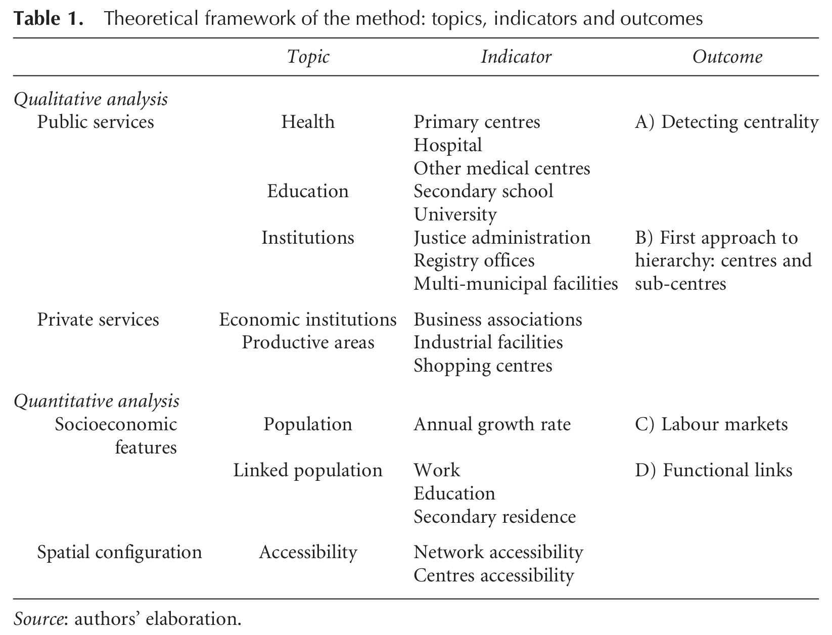
Source: authors’ elaboration.
With this general framework, we have outlined the problems surrounding areas of reduced demographic density. The processes associated with the economies of urban agglomeration and diffusion have generated some territorial divergence, in which sparsely populated regions have been gradually increasing their dependence on the cities and service hubs in the more densely populated areas. Among other considerations, job markets have undergone modifications to their relational and hierarchical structures, particularly in the territorial areas to which we refer.
As Table 1 shows, the working process can be summed up in four successive steps, which one by one allowed us to accomplish our goals: detect centrality; approach the centre’s hierarchy; depict the labour markets; and, understand the functional links.
The main limitation that we found when performing an in-depth analysis of the functional structures of territorial areas, such as the one proposed, was the availability of enough relevant information to allow us to establish suitable connections.
Steps A and B were taken following a cumulative opportunities approach, building a database including the availability of services and facilities throughout the study area. Step A corresponds to a preliminary phase aimed to detect centrality in municipalities. The identification was carried out carefully in a previous research (Pillet et al., 2007) and gathers information related to the public and private sectors, specifically the presence (or absence) of a certain level of services related to these institutions (expressed in the indicators column, Table 1). Each topic was detailed in a specific database and subsequently analysed cartographically in order to evaluate centrality. The result of the analysis proves the existence of peripheral and rural municipalities with a relatively high degree of centrality when comparing with cities of greater size in terms of services available. Step B analyses the level of specialisation behind each indicator included in step A in order to build a first hierarchy of nodes that will allow a first interpretation for the urban role in the system.
The goal was to detect and evaluate the level of centrality in the study area, a key factor to understanding the functionality analysed in steps C and D. First, step C considers important the calculation of the annual growth rate in order to identify the most dynamic areas and which present a higher rate of demographic decrease in Castilla–La Mancha. Its analysis is crucial in terms of demand for infrastructure, greater or lesser accessibility, or economic dynamism, aside of being an optimum tool for a better understanding of the FUA.
After reviewing the most appropriate sources for carrying out the analysis of labour markets, we concluded that the notion of población vinculada (linked population) extracted from the 2001 Censo Oficial de Población (Official Population Census) was well suited to starting the analysis of the territorial structures and polycentrism in Spain for several reasons. The most important one for the aim of this paper was that this feature includes all the municipalities, regardless of their size. The information gathered gives information about the relations between municipalities regarding three connection options: people can be linked due to studies, a second home or employment reasons. These relations mean that a person living in a given municipality declares links for such reasons with another municipality. This allows the building of pairs of connections for the whole census sample.
In the latter connection option, a work connection, relationships are established between the municipalities of residence and those of work, clearly reflecting forced (and frequent) mobility and, consequently, establishing the limits of the labour markets. The main limitation of these data is their frequency, collected once every 10 years (the census interval time), so it is necessary to wait for the 2011 release to see possible changes and evolution.
The fourth step concerns functionality beyond the work-related links. As the scientific literature stated, there are several ways to approach this goal; in this analysis, precedence was given to the overall interpretation of the source (linked population) and it was applied to each type of connection (labour, studies and second residency) because of the usefulness of establishing connections for the whole area and the cartographical applicability.
Hence, together with this relevant data source, the paper established two areas of interest with different methodological approaches that were later integrated into the conclusions: the analysis of spatial labour-based relations in municipalities with central functions (Pillet et al., 2007, p. 635) independently of their demographic size (which is step C) and the analysis of the region’s transport structure (step D) and accessibility to the centres. For the present article, we also employed the results of the research project performed by Martínez (2010) when analysing the regional transport and communications structures, more specifically when defining the areas of the centres to solve problems of assignation. These problems were mainly the edge municipalities (with at least two centres with similar potential of attraction) and the sub-centre linkage with a leading centre. The cited study contributes with an extensive dataset of accessibility results which allows solving both problems and finishing the delimitation process.
3.2 Analysis and Delimitation Process
Within this methodological proposal the main effort required, apart from the availability and relevance of indicators, is the data management. A geo-referenced database, working via GIS (geographical information system) software, offers two main advantages: data management and relevant cartographical options. The most important task is to depict the origins and destinations of the population with the aim of detecting the main flow attraction nodes and exploring how the labour market is beginning to take shape in the study area. Therefore, those flows were the main source used in the delimitation of the resulting areas.
The geo-database built includes disaggregated information on the flows established in the census among all the other indicators. The resulting base allowed us to relate each forced mobility flow to some of the functional centres and sub-centres (rural municipalities with central functions detected) identified, the destinations of all these and the origins of all the municipalities included in the study area. These flows can be considered vectors Fij,
After the population flows had been established and a homogeneous database that was suitably configured in the software obtained, we wanted to consider the real annual growth by municipalities for the period between the last Censo Oficial de Población (Official Population Census) in 2001 and the last Padrón Municipal de Habitantes (Municipal Register of Inhabitants) of 2009, the main sources of demographic statistics in Spain. The objective here was not to lose sight of the more dynamic areas and those with greater demographic regression.
The delimitation process to characterise and study the polycentric structure of functional relationships in the overall region consisted of three main steps. First, we looked only at the intermunicipal flows (Fij ). For each i, we looked for overlapping in the most frequent relation, to check whether destination j was the same for each component. In the case of a triple overlap (Wij, Sij and Rij shared the same j), the methodology assigned the municipality of origin automatically to the destination’s functional area. This was the most frequent case and caused the immediate assignment of approximately 60 per cent of the cases analysed. As the first criterion, this allowed municipalities connected to others to be defined solely and exclusively, a frequent situation in the outlying regions of the most important urban hubs where areas of strong functional interrelations are being consolidated.
Secondly, if there was not full matching in the destinations (different js) or, conversely, two city hubs of similar weight shared a ranking in the destination (two competing js), work (Wij ) was given priority as the decisive component and, in parallel, the accessibility database was consulted. We believe that the functional area is more completely shaped by establishing a direct connection with the labour market. This second criterion, used to complete practically all the cases, was established after verifying a frequent problem within provincial structures based on the trend of each hub to connect preferentially to its provincial capital. In the majority of cases, when analysing only the work variable, we could establish a link with another centre, which also revealed greater proximity than the first-order connection. This last issue is important, as we believe that the functional structure is also based on the proximity factor, which is the reason why we weighted work preferentially in the analysis of the linked population.
Lastly, we found several examples of municipalities with no known assignment (their small size provokes their absence in some data sources) or with specific problems. In these situations, we applied an analysis of the specific cases, turning to other sources (territorial aggregations, association with surrounding towns, etc.) to throw light on whether the municipality belongs to one area or another. This latter case was preferably applied to areas with very low demographic density, where hubs are frequently found with no connection flow relationships and, therefore, the delimitation of functional areas had to be adapted to this circumstance.
4. Empirical Application: the Castilla–La Mancha Case Study
Castilla–La Mancha is the region on which we will focus our empirical analysis. It is a Spanish autonomous community (ES42), arising from the new administrative structure following the 1978 Spanish Constitution. This region, like the rest of the Spanish autonomous communities, arose after the implementation of a new organisational structure at the beginning of the 1980s. This structure granted growing political importance to the intermediate stage between the nation and the local administration. By way of example, in the shaping of job markets, its impact is most noteworthy due to its ability to execute numerous important competences in society and in territories.
In recent years, the Spanish urban network has been reorganised and its structuring capacity increased. Nevertheless, the location of the main cities follows a general centre–periphery pattern and we can find large spaces between the bigger cities with low-density population patterns, as Figure 1 shows. It is worth pointing out that the application of the analysis proposed in Castilla–La Mancha allowed us to associate each municipality with its correspondent functional hub of reference (centre or sub-centre), making it possible to define areas of influence. The scope of application of this methodology includes all 919 municipalities in the region, covering its total area of nearly 80,000 km2.
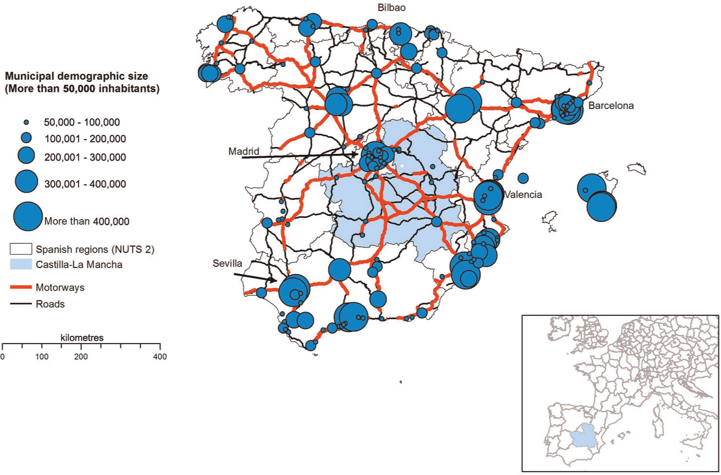
Urban areas in Spain (more than 10,000 inhabitants) and the position of Castilla–La Mancha in UE-27 (NUTS 2).
4.1 Keynotes about the Region
Castilla–La Mancha is a region located in inland Spain, between the regions of Madrid in the centre, Andalusia in the south and Valencia in the east. Its geographical extension represents 14 per cent of the nation, but only 4 per cent of the country’s total population. The autonomous community is divided into five provinces (Toledo ES425, Albacete ES421, Ciudad Real ES422, Guadalajara ES424 and Cuenca ES423) with different structures and dynamics, yet a common trend: all of them have a somewhat close relationship with urban areas outside the region and weakly interrelate with each other. This is partly due to the reduced general demographic density of the region (24 inhabitants per square km), one of the lowest in the nation. Despite positive demographic changes in recent years, the growth is distributed unequally across the territories, with the population decreasing in the most rural and peripheral areas and growth concentrated close to the border with Madrid and around the provincial capitals (Pillet et al., 2010). According to analyses (Santos, 2008), the last population census revealed that 752 of the 919 municipalities of Castilla–La Mancha were deemed to be rural by the INE (Spanish Statistics Institute) due to having fewer than 2000 inhabitants. Of this latter group, 76 per cent lost population in the last intercensal period, with the percentage dropping to 67 per cent if all the regional municipalities are taken into consideration. These figures contrast with the overall positive evolution in the region (1,755,053 in 2001 and 2,098,373 in 2010) and confirm the dissymmetry in the distribution of the population. Ageing problems must be added to this, which worsen as the size of the municipalities reduces, with the percentage of elderly people over 65 years of age reaching 38 per cent of the regional total, with figures rising higher in the outlying mountainous areas (44.4 per cent in the province of Guadalajara). One could say that the overall demographic boom, which occurs particularly in more urbanised areas, cannot hide the duality and specific problems of rural regions and that these characteristics have a negative impact on the sparse structuring of the territory, where the urban hierarchy is also conditioned by areas of great renown outside the region.
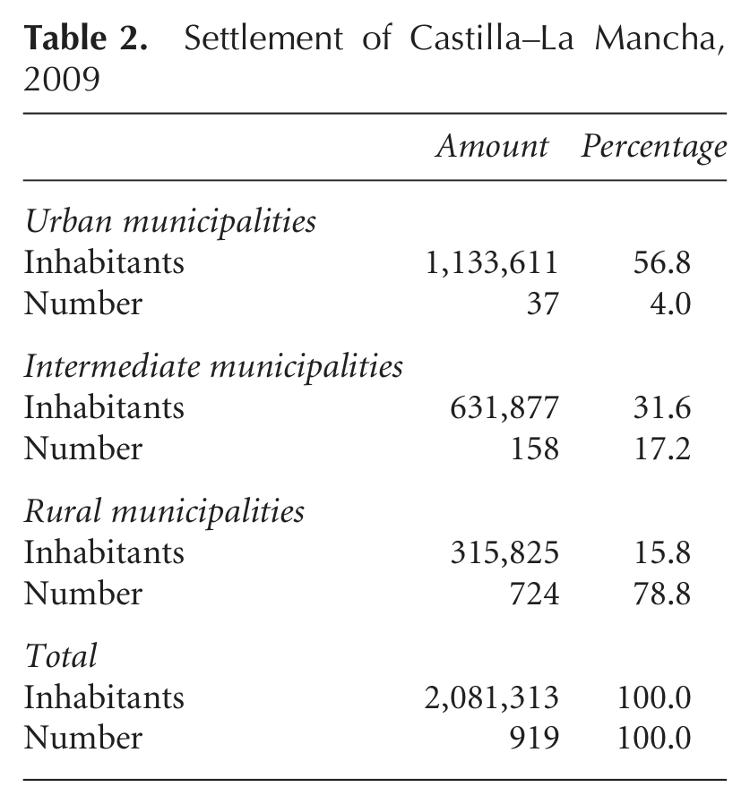
Table 2 and its accompanying figure, with more updated data, reflect the settlement structure in which the important weight of rural municipalities can be appreciated (80 per cent), with respect to urban ones (4 per cent), owing to the deep dichotomy established between areas in the plains and areas in the mountains. This is an important repercussion that the demographic data have for the dual organisation of the territory. The plains (Vega del Tajo and La Mancha) are settlement sites of a series of small and medium-sized cities that either appeared in the outlying areas of the metropolis of Madrid and were organised through industrial corridors or were established as a result of their role as support for the radial communication networks that, moving out from Madrid, crossed the region to connect Andalusia in the south and Valencia in the east. Other small-sized places with important production specialisations should not be forgotten; these are distributed over the most central part of the region and presently have economic growth, wellbeing, sustainability and participation indicators, as well as incorporation into the knowledge society, that are larger than expected in terms of size or accessibility to large activity or economic specialisation centres (Méndez et al., 2006, p. 91). The figure with this table (Figure 2) shows the weak hierarchical structure mentioned, as only seven cities have more than 40,000 inhabitants and 18 do not reach 20,000 inhabitants.
Settlement of Castilla–La Mancha, 2009

Urban hierarchy of Castilla–La Mancha, 2009.
Two thoughts are pertinent to this structure: the great significance of the Madrid metropolitan area in the regional bordering areas and, secondly, the fact that the possible territorial articulation will be carried out through a demographic duality and an urban structure in which there is no single governing hub able to organise the territory, with medium mountainous regions with strong depopulation processes, in a territory with clear shortcomings in its communications network. This is because the regional road network between the capitals and the main urban cores has different degrees of planning and execution (Martínez, 2010).
It is necessary to specify that, as the European scale is ruled by the ‘pentagon’ of cities in the top of the urban hierarchy (London, Paris, Milan, Munich and Hamburg), the Spanish national scope shows a two-headed urban system headed by Madrid and Barcelona and followed by the secondary rank (Valencia, Bilbao, Sevilla, etc.). Obviously, Madrid is the metropolis which organises and leads the interior of the Spanish peninsular space and its regions (Extremadura, Castilla y León, Aragón and Castilla–La Mancha) given its demographic size (3,265,038 inhabitants in 2011) and its potential of attraction, essentially in relation to its labour market and commercial activities.
Therefore, it can be said that Castilla–La Mancha has been incorporated inside Madrid’s urban system. However, this fact has no administrative effects as long as it is about two different Autonomous Regions (Castilla–La Mancha and Comunidad de Madrid, both NUTS 3). The regional policy of land planning in Castilla–La Mancha demands, in this sense, consideration of only the regional cities at the top of the urban hierarchy, descending later to other less important municipalities. It is for this reason that this paper proposes a polycentric structure based on functional urban areas (FUAs) excluding Madrid.
4.2 The Communications Model
In this section, we follow a good number of the conclusions obtained in the research project conducted by Martínez (2010), added as a parallel line to the principal research carried out by this group. Its objective was to find out, characterise and evaluate the essential features of the region’s transport system, thus being able to link the results with the main line of research.
The communications structure in Spain is still highly influenced by the network of centre–periphery infrastructures designed for the efficient connection of Madrid with the most dynamic urban peripheries in Spain (primarily Barcelona, Bilbao, Valencia and Seville), where the intermediate spaces have merited little or no attention. In Castilla–La Mancha, the situation is basically conditioned by two effects: the first, the inland links with respect to the radial axes, which generate corridor-type territorial structures, and the second, the dominant role of Madrid, as the centre and origin of this structure, which dominates the region’s territorial relations and organises them along these corridors. This role is not only the consequence of the communications structure, but must also be attributed to the hierarchy that the capital itself has generated in different territorial models followed in Spain until the advent of democracy in 1978, with the approval of the constitution presently in force. As mentioned, it created the autonomous communities and granted them important roles in the structuring and organisation of the Spanish space, among other significant powers that have grown progressively until shaping the present model of the Spanish ‘State of the Autonomous Regions’.
With respect to the issue in question here, autonomous governments have gradually tried to subdue the radial structure of communications. They have been supported by the Spanish central government, which deemed the radial network to be finished in the past decade and has now established the transversality of the network as a priority objective. A result of this change in the direction of the national strategy and the introduction of the regional scale in planning infrastructures has been the modification of this extreme radial structure for gradual transversality, the most noteworthy features of which are
— Increased connectivity in the capitals of each province, at times strengthening the provisional hierarchies.
— Progressive concentration of the network in regional city centres, which gradually increases their differences with regard to the more rural peripheries.
— Strengthening of the differences in the network hierarchy, both on roads and on the railway. Conventional roads and the conventional railway lose relevance in the communications structure.
The result of all this has been an internal rebalancing that has never questioned Madrid’s role in the regional system, verified in the dissemination of sprawl processes in its metropolitan area due to the road improvements and the development of new motorways. Improvements to the infrastructures and the insertion of new corridors did not replace either the general network structure or the trend acquired. The increase in motorisation indexes and urban sprawl are phenomena that can be noticed in Castilla–La Mancha as an effect of Madrid’s urban sprawl.
Moreover, the large investment made in high-speed rail has transferred to the region, reproducing the same radial model, accentuating the functional dependence on the outer regions. Along with this, from an inland viewpoint, the urban–rural differences have increased and the provincial hierarchies strengthened, which are weakly interrelated.
In summary, attempts to complete the regional communications network have still not managed to break free from a structure that is inadequate for moving towards territorial connections and good organisation. This situation is therefore not favourable for the application of regional planning and structuring policies that split from the duality between the more populated areas on the plains, where infrastructures tend to be concentrated, and the outlying and mountainous areas, which are quite unpopulated and suffer from important shortages in these issues.
4.3 The Functional Urban Structure
Taking into consideration all the aspects that we listed and applying them to Castilla–La Mancha, we obtained an initial mapping of centres and sub-centres (Pillet et al., 2007), which depicts all the flows that are established using the ties stemming from the linked population. The location of the municipalities with higher populations in the centre and in the areas surrounding Madrid is very obvious, as well as the intensity of the flow. Conversely, particularly in the peripheries, this is weaker. The result, already published (Pillet et al., 2010), schematises the structure of polycentrism in the region with a work-related mobility predominance (Figure 3 will show part of this result, pointing out the labour market structure).

Functional urban areas in Castilla–La Mancha and their dependent areas.
To analyse the map resulting from polycentrism in greater detail, three issues were taken into account: the demographic difference between centres and sub-centres (2009); the greater or lesser intensity of flows according to the linked population with respect to a centre (2001); and, thirdly, the real annual growth in recent years (2001–09). The aim was to try to clarify the demographic change in these structures over time, as the source employed has not been updated since the 2001 census.
As a result, a total of 19 municipalities were obtained with more than 15,000 inhabitants in the last municipal census in 2008. However, their uneven locations present their absence from the regional periphery as an initial result. This circumstance made it necessary to consider a further 12 municipalities, the population of which varies between 15,000 and 3000 inhabitants, all with facilities favouring population flows, although to a lesser degree (Table 3).
Demographic change in main municipalities in Castilla–La Mancha
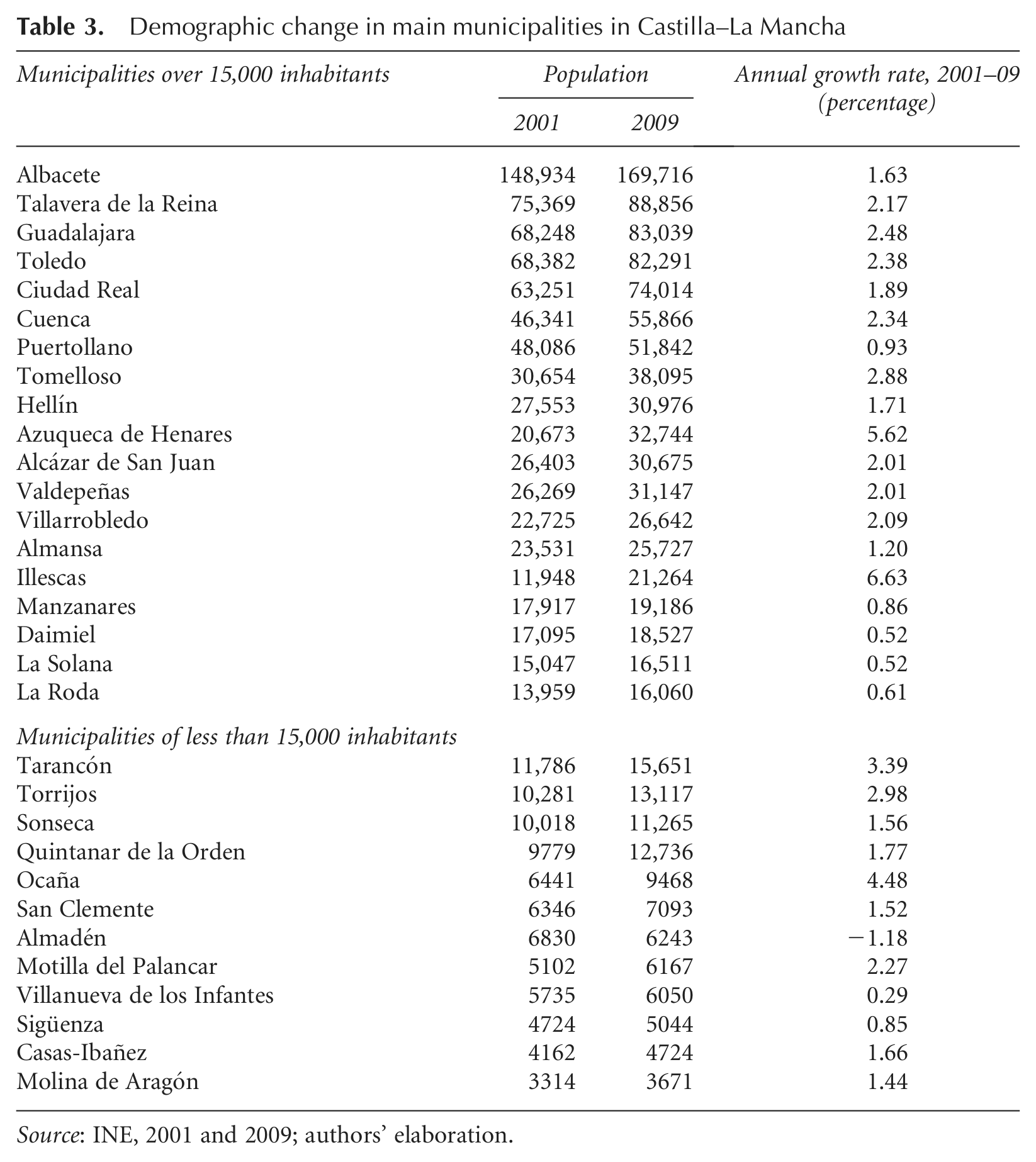
Source: INE, 2001 and 2009; authors’ elaboration.
As in other cases, medium and small-sized urban hubs comply with the function of district leaders, taking on a clearly leading role as potentially rebalancing city centres, although on a regional scale here.
If we first focus on those that exceed the established threshold, urban centres with more than 15,000 inhabitants, Albacete leads as the most populated city, located in the far south-east, and the only hub that clearly exceeds 100,000 inhabitants. Following Albacete and with more than 50,000 inhabitants are Talavera de la Reina, Guadalajara, Toledo, Ciudad Real, Cuenca and Puertollano. We added a series of hubs to these, such as Tomelloso, Alcázar de San Juan, Valdepeñas, Azuqueca de Henares, Hellín, Villarrobledo, Almansa and Illescas (the last hub is the only one that had under 15,000 inhabitants in 2001), as well as Manzanares, Daimiel, La Solana and La Roda.
If we take a look now at the real annual growth in the 2001–09 period, its diversity is apparent, although two municipalities stand out above the rest: Illescas (6.63 per cent) and Azuqueca de Henares (5.62 per cent). With more than 2 per cent are Tomelloso (2.88 per cent), Guadalajara (2.48 per cent), Toledo (2.38 per cent), Cuenca (2.34 per cent), Talavera de la Reina (2.17 per cent), Villarrobledo (2.09 per cent), Alcázar de San Juan and Valdepeñas (2.01 per cent). A third level contains Ciudad Real (1.89 per cent), Hellín (1.71 per cent), Albacete (1.63 per cent), Almansa (1.20 per cent) and, lastly, Puertollano (0.93 per cent), Manzanares (0.86 per cent) and La Roda (0.61 per cent), concluding with Daimiel and La Solana (0.52 per cent). With regard to hubs with fewer than 15,000 inhabitants, standing out are: Ocaña (4.48 per cent), Tarancón (3.39 per cent) and Torrijos (2.98 per cent), all three of which are located in the regional periphery subjected to influence from Madrid. The first conclusion we can draw with respect to urban centres is that, while those bordering the Community of Madrid have the greatest growth rates, those with the least dynamism are located in the south and the regional peripheries.
4.4 Formation of the Labour Markets
Applying this, we can now tackle the structure of labour markets in this territory. Figure 3 schematises and condenses the most relevant information obtained, which is clearly not the only information, given that the spatial data structure built in the GIS admits more results.
From the distribution of centres and sub-centres, demographic growth, the analysis of linked population flows and the layout of the transport network, we can obtain the configuration of the main functional areas with regard to labour mobility (commuting), also obtaining an initial approach to the polycentric structure of Castilla–La Mancha.
The organisation of labour mobility reveals the important influence exercised by the largest demographic urban hubs in their most immediate geographical environment, corresponding to the provincial capitals in most cases. The importance of the road network is also revealed when these flows are established and developed, representing basic elements in regional spatial structuring.
Figure 3 shows the 10 delimited functional urban areas (Pillet et al., 2010), basically comprising an urban centre with some functional importance, a specific demographic range and territories with variable sizes and characteristics located nearby that can be defined as the area in which interterritorial relations are very strong, with regard to essentially labour connections tied to services and facilities.
The characteristics of these FUAs are also very different. Some have perfectly delimited centres and areas of influence, as is the case in Talavera, Illescas and Alcázar-Tomelloso (of which the latter is the only bicephalous case). Other cases show greater complexity due to having a variable number of secondary urban centres, different from the main centre of the FUA, but dependent on it. The number of these dependent areas and the complexity of the FUA are variable and are not directly related either to its size or to its demographic importance, being a matter of qualitative factors such as the number of services and the hierarchy of them (mainly educational and health services).
Based on these indicators, the FUAs that have a regional capital as an urban centre stand out. In this regard, Toledo has four dependent areas; Albacete and Cuenca have three each and one shared dependent area; Guadalajara has two; and Ciudad Real has one dependent area, whereas Puertollano and Valdepeñas have urban areas of influence with a simple structure, one main centre and only one dependent area inland.
By way of a conclusion, we can say that there are in total 10 main functional urban areas, seven of which have some type of functional structure of varying complexity, and 15 dependent areas. Internal regional movements are organised around them, with the flows towards cities with political/administrative functions and some services being noteworthy. This number is not far from the 21 geographical districts delimited in the region (Panadero and Pillet, 1999) or the 30 groups designed for the application of rural development policies with a LEADER approach. This means that the scale around which commuting and mobility flows are organised, which are associated with other variables like the consumption of different-level goods and services, is not far from the district dimension.
5. Conclusions
From the open and flexible approach arising from the European Territorial Strategy, the new urban spatial organisation model recommends the implementation of a balanced and polycentric urban system starting from hubs with over 15,000 inhabitants and enough competences in the region to be able to organise an FUA (functional urban area) that must surpass 50,000 inhabitants. In short, this is polycentrism, which complements and profiles the traditional Spanish model of provincial capitals and small and medium-sized cities with centrality functions in the surrounding rural setting. From the viewpoint of the ESDP and the new territorial development focus proposed, these are profiled as the urban hubs that must be strengthened. The role they play as service distributors and functional leaders at the level of labour and mobility markets is strengthened by their identification at a district scale. In spaces with low population densities, which are our focus, they seem to be the key to proper structuring.
Taking these principles into account, as well as the changes that could occur in the upcoming years to the road, motorway and high-speed train networks, a total of 10 functional urban areas (FUAs) were identified, starting from flows that offer the linked population presented for the first time in the 2001 population census and taking into account the population growth between the Censo Oficial de Población (Official Population Census) of 2001 and the last Padrón Municipal de Habitantes (Municipal Inhabitants Census) of 2008. However, due to the fact that they are autonomous communities with an extremely low population density and are sparsely developed, particularly in the periphery, a total of 15 dependent areas were also delimited, five with urban centres greater than 15,000 inhabitants, which we call the first level, and 10 others, or sub-centres, which we call the second level. In this way, while eight FUAs control all the dependent areas, the two remaining ones do not (Talavera de la Reina and Illescas).
We can classify the 10 FUAs presented into three large groups according to their nature and location: FUAs located in the periphery of Madrid; FUAs of the remaining provincial capitals; and FUAs connected to small and medium-sized cities. In short, they are very dynamic, based on their demographic growth. The majority are in contact with the Community of Madrid, while those with lower or negative growth rates are located in the west and peripheries. Furthermore, this analysis must be flexible as the AVE (high-speed train) and the new roads and toll motorways can cause changes that are not foreseeable now, but will have to be considered later.
The current financial crisis, coupled with the public-sector indebtedness, has given rise to a debate about the territorial organisation model in Spain. It would be logical that the different administrative levels (municipality, province, autonomous community) were analysed from spatial planning, making room for important decisions such as the regrouping of municipalities and the development of supra scales not only to optimise economic resources, but also for optimising the territory management. The design of functional urban areas resulting from the momentum to the polycentrism carried out by the European Spatial Development Perspective can become the basic axis of management and territorial cohesion in the present century.
To conclude, it must be pointed out that we expect the results presented herein to be taken into account in the future Territorial Strategy for Castilla–La Mancha (partly designed by the regional government). Since we are in the century of cities, we believe the commitment to polycentrism and its corresponding functional urban areas to be particularly relevant as key issues in territorial development and territorial cohesion.
The methodology allowed the delimitation of these FUAs in the Spanish context, revealing an adequate instrument for low-density areas. In this case, the availability of data for a whole sample is the general limitation for such a methodology and, more specifically, the dependence of a source able to connect origins and destinations (centres and sub-centres). Despite the inability of the specific procedure to be applied in other countries because of the specific datasets used, the rationale of the methodology can help in the European framework to approach the analysis of polycentrism in low-density regions.
In a spatial setting like modern-day Europe and an economic and social situation like the present, the spatial structures that we found are necessarily complex. Within this complexity, policies must allow space for operational application that lets the necessary objectives of territorial equilibrium and sustainability move forward.
Footnotes
Acknowledgements
The authors would like to thank the valuable and interesting comments made by the two anonymous referees which undoubtedly contributed to improving the paper.
Funding
This paper is a result of the Research Project PCI08-0031-2852 funded by the Consejería de Educación y Ciencia (Junta de Comunidades de Castilla–La Mancha).