
Abstract
Processes of urbanisation can hardly be considered without reference to the spaces that lie between developments. However, the literature on such interstitial spaces is fragmentary. In this paper we draw together insights from the extant literature into a research agenda on urban interstices. We propose a research agenda centred on four themes: the multiple geographic scales at which the interstitial spaces of urban sprawl might be analysed; the pending nature of such spaces; their planned or unplanned character and their relational properties. We develop these themes, briefly illustrating them with reference to the case of metropolitan area of Santiago de Chile. In conclusion, we emphasise some of the implications of interstitial spaces for theories of urban politics and their value in forcing inter-disciplinarity in urban studies.
Introduction
The multifaceted nature of (sub)urban sprawl has been clarified recently (Galster et al., 2001) while discussion of the social, economic and political processes operating on, the environmental content and ideological meaning of, the real estate developments that compose it found in literature on (post)suburbanisation (Ekers et al., 2012; Phelps and Wood, 2011; Phelps et al., 2010).
Yet urbanisation can hardly be considered without reference to the undeveloped spaces between developments. To an extent, undeveloped land represents natural or regulatory constraints on developable land and affects the measurement of urban sprawl (Wolman et al., 2005). Quite apart from the facts that some such constraints are social or regulatory constructions which can be unmade or are natural features that could be ‘improved’ or ‘reclaimed’ to allow development, vacant lands have been calculated to be substantial in American cities (Northam, 1971) and they may be on the increase in contexts of urban shrinkage (Dubeaux and Sabot, 2018). We should be mindful of the quantitative significance of these gaps.
Vacant spaces might be considered inert non-places (Augé, 1995; Relph, 1976). Nothing could be further from the truth, as a diverse extant literature on urban interstices emphasises (Brighenti, 2013; Choay, 2003; Foo et al., 2013; Gandy, 2009; Lévesque, 2013; Matos, 2009; Mohammadi et al., 2012; Vidal, 2002). Rather, ‘when one penetrates the system of interstitial spaces and starts to explore it, one realises that what has been called “empty” is not so empty after all. Instead, it contains a wide range of uses’ (Matos, 2009: 66). Urban interstices comprise ‘a parallel city with its own dynamics and structures that have yet to be understood’ (Careri, 2002: 184) and yet are ‘fundamental to the future of our cities’ (Matos, 2009: 65). We should be mindful of the qualities of these gaps.
Interstitial spaces offer an alternative analytical point of entry into the study of urbanisation. The extant literature uses a variety of terms, is fragmented and quite singular in its treatment of interstitial spaces in architectural, ecological or other terms. Here we present a unifying research agenda for understanding urban interstices. We begin by reviewing the literature that does touch on such interstitial spaces including that on urban fringe belts, green infrastructure, Sieverts’s zwischenstadt and Vidal’s inter-fragmentary spaces. These provide insights that we pull together in a subsequent section which presents four themes in a future agenda for research on the interstices of urban sprawl, namely: the scale at which interstitial spaces are apparent; their pending nature; their relationship to planning; and their relational properties. We provide brief examples of these themes taken from original research of interstitial spaces in the metropolitan area of Santiago de Chile involving reviews of official documents and 56 semi-structured interviews with central, metropolitan and local government planners, politicians, developers and business interests, residents and environments and other community groups (Silva, 2017a). We draw only lightly upon this case as a basis for abstraction and generalisation, though we believe the agenda is one that has salience to the vast majority of cities. Santiago de Chile provides a good example of the significance of interstitial spaces in a context of urban sprawl specifically. The city-region has been the subject of fragmented urban expansion linked to both ‘autoconstruction’ and privatised construction of housing and infrastructure in the past three decades with important consequences for social segregation (Borsdorf et al., 2007; Dammert, 2004; De Mattos, 2002; Heinrichs et al., 2011; Sabatini et al., 2001). Less examined are the vacant spaces produced alongside the urbanisation processes described by these authors. The original research focused on the south of Santiago de Chile – the most important axis for recent suburban expansion – and involved mapping and study of interstices identified as the most important by interviewees (see Figure 1). The conclusions underline the value of integrating insights from the different disciplines concerned with the built environment but also the wider ramifications of this agenda for the field of urban studies: planning practice is brought to the centre of urban economic and geographical analysis; the competing interests operative on interstitial spaces lead directly to the question of ‘whose city?’ so central to theories of elite and grassroots urban politics; consideration of interstitial spaces necessarily leads in the direction of both scalar and relational ontologies.

Santiago de Chile and the spectrum of interstitial spaces.
Antecedents in the discussion of the interstitial spaces of urban sprawl
A range of terms have been used which partly acknowledge undeveloped or underdeveloped land as part of urban sprawl – the concepts of fringe belts, green infrastructure, zwischenstadt and interfragmentary spaces being notable.
Fringe belts: The functional diversity of non-urbanised land
Notions of the urban fringe, fringe belt and expansion areas have been important in the urban morphological tradition. To the extent that the emphasis in this literature is on the morphological complexity of fringe areas, it also highlights the diversity of forces and interests involved in urban sprawl, including those operating upon interstitial spaces. Hebbert (1986: 141), for example, emphasises how the transitional zone surrounding cities ‘displays a mixture of uses and building types interspersed with agricultural and vacant land’. This literature also underlines a temporal dimension which needs to be made a part of any research agenda on the interstices of (sub)urban sprawl.
A fringe belt can be described as ‘a zone of largely extensive land uses that is formed at the edges of an urban area during a pause in outward residential growth. Each fringe belt … has several distinctive features in terms of plan, building form, and land and building uses. Typical uses requiring extensive sites, include public utilities, parks, sports facilities, and allotment gardens’ (Larkham, 2006: 126–127). For Gallent and Shaw (2007), urban fringes are complex because of their random assemblage of morphologies and land uses. The physical and functional transformation of urban fringes implies tensions between existing and encroaching uses which can exist over extensive periods of time to create multi-functional landscapes (Whitehand and Morton, 2004).
The morphology of the fringe belt is partly a reflection of ‘leapfrog’ development; non-contiguous urbanisation made up by the presence of those open tracts in between such as farmlands, forest lands and other non-urbanised areas. In Gillham’s (2002: 4–5) words ‘the result is a haphazard patchwork, widely spread apart and seeming to consume far more land than contiguous developments. Unless preserved or unbuildable, the remaining open tracts are usually filled with new developments as time progresses’. Whitehand and Morton’s (2004) study of Birmingham’s Edwardian fringe belt reveals just how scattered the fragments of undeveloped or underdeveloped spaces left within the belt can be.
The unique pressures in the urban fringe belt have been important for promoting macro-scale planning policies designed to preserve and promote open areas such as the ‘Five-Finger Plan’ of Copenhagen (Caspersen et al., 2006; Gravsholt Busk et al., 2006) and the ‘Green-Heart’ project in Netherlands (Faludi et al., 1996; Kühn, 2003; Salet and Woltjer, 2009). Yet the fact that ‘an unintended fringe belt may contribute as much to the legibility of a city as a fringe belt with a planned feature’ (Whitehand, 2001: 108) underlines both the planned and unplanned nature of interstitial spaces – a point to which we return later.
Time is a critical factor in the measurement of sprawl because – more than a description of a moment – sprawl is a process (Galster et al., 2001). Sprawl, as a particular pattern of expansion, is recognised in such indicators as land conversion, population change, traffic and vehicle miles travelled energy consumption and fiscal measures (Nelson, 1999). Fringe belts and ‘expansion areas’ are always therefore ‘pending’ spaces under the logic speculation surrounding land development – though this is rarely a feature emphasised explicitly. Their condition centres on their accessibility or location relative to infrastructure and existing development as in the case of the Randstad in the Netherlands (Bruinsma et al., 1993). The morphology of fringe belts in particular reflects the enduring obstacles to, different cycles of, and innovation in, building activity over time (Whitehand, 2001).
Green infrastructure: The ecological content of non-urbanised land
The concept of green infrastructure is associated with prospects for ecological modernisation – as a way ‘for the environment to support economic growth and investment, land property values, labour productivity, tourism and agriculture’ (Thomas and Littlewood, 2010: 217). Van Leeuwen and Nijkamp, (2006: 292) detect possibilities for green infrastructure in an ‘urbanised countryside’ to provide for a shift from the productivist farming which typically denuded natural processes, towards an agricultural sector in urban fringes having a greater focus on food quality, environmental processes, and more sustainable ecosystems.
The scope of the green infrastructure concept is broad since it embraces the entire city from the fringe to the city’s core – signalling the need for a focus on a variety of scales of analysis. Green infrastructure consists of interconnected networks of spaces which are part of ecosystems including parks, squares, green corridors, waterways, woodlands, public places, etc. It is these multi-scalar and relational properties of green infrastructure as networks of places that we return to latter when elaborating the concept of the interstices of (sub)urban sprawl.
Aside from their contributions to urban amenity, the ecological value of green infrastructure in terms of preventing the loss of biodiversity, mitigating or reducing air and noise pollution seem beyond doubt (La Rosa and Privitera, 2013). However, according to Lafortezza et al. (2013), these areas generally have two main components: ‘hubs’ and ‘corridors’ that involve several scales and functions where people can share some expressions of wildlife. The concept of green infrastructure also supposes claims on political and policy leadership and resourcing similar to those of ‘traditional’ infrastructure (Sandström, 2002). Green-infrastructure has entered into land use and spatial planning policy; being understood as ‘ecological-networks’ (Bennet and Mulongoy, 2006; Tzoulas et al., 2007; Walmsley, 1995) but also as having a value in terms of contributing to the quality of the urban environment (La Greca et al., 2011: 2193).
Zwischenstadt: The regional-scale city in-between
The term zwischenstadt or ‘in-between’ territory has been used to depict a new urban landscape (Sieverts, 2003, 2011) drawing attention to several features. First, the term refers primarily to the urban-regional scale. Second, it focuses largely on the mixing of urban and rural land. Third, there is an emphasis on the political and regulatory processes that have produced this landscape.
The term zwischensdtadt describes a new form of urbanisation that is neither city nor country but instead the ‘urbanised landscape’ existing between the historical city centre and the open countryside (Sieverts, 2003). According to Sieverts (2003, 2011) the zwischenstadt is characterised by different degrees of urbanisation and its diversity is related to the extent and scale of undeveloped land. The space that Sieverts refers to is characterised by a blend of land uses and activities. In the zwischenstadt landscape, as others have described, open areas such as ‘urban agriculture’ are a result of the mixing between social and economic demands from urban surroundings (Tacoli, 1998: 157–158). The countryside shows some expressions of urbanity such as farmlands for public visits, tourism activities and leisure places, etc. Moreover, urban surroundings start to define ways of life in that nearby urban fragments and infrastructure provide rural residents employment and access to urban cultural activities (Van Leeuwen and Nijkamp, 2006: 294).
‘In-between’ territory involves the whole suburban context mainly defined as a scattered process of development where several insulated built-up places coexist with pieces of countryside (Sieverts, 2003: 5–6). While the emphasis of Sieverts’ discussion is not upon interstitial spaces per se, one of the key points to take from his concern with the in-between city is the significance of fragments of undeveloped land that exist at the regional scale. Partly because of the existence of these interstices and their regional scale, ‘the fragmented urban landscape is not yet seen as part of our culture’ (Sieverts, 2011: 20). That is, ‘the in-between city is still unloved particularly by planners and opinion makers, and it is disregarded by urban design, planning and politics’ (Sieverts, 2011: 20). Here interstitial spaces are implicated in a set of political, economic, environmental, regulatory and, to a lesser extent, cultural conflicts that beset the zwischenstadt since ‘the open space of the landscape will become the actual creative field … of the zwischenstadt’ (Sieverts, 2003: 122). What Sieverts has in mind here are conflicts ‘to do with the funding of regionally significant facilities, the retention and maintenance of open landscapes, the social segregation between the old city and the periphery and the migration of businesses from the core countries into the hinterland’ (Sieverts, 2003: 127).
The relationality of inter-fragmentary spaces
Vidal’s (1999, 2002) idea of ‘inter-fragmentary space’ emerged from a desire to explore the cross-boundary relations subsumed in Raffestin’s (1986) emphasis upon the construction of boundaries and has two key features. First, the concept refers to the architectonic scale between different urban fragments. Second, Vidal’s approach is explicit on the potential and relationality of inter-fragmentary spaces as a result of changes to surrounding fragments and infrastructure of the built environment.
To understand ‘inter-fragmentary space’ it is necessary to consider that ‘the urban phenomenon is essentially a permanent tension between fragments’ (Vidal, 2002: 150). Thus, the relationship between urban fragments occurs through the inter-fragmentary space. The view of the contemporary city as one of fragments is not unique but the connotation of the term fragmentation is. For many, ‘urban fragmentation’ amounts to forms of segregation and has negative social, economic and political consequences. For Vidal, ‘urban fragmentation’ is a description of the potentialities of cities as territories made up of different physical entities with political, economic and social dimensions. Urban fragmentation is a process of ‘addition or subtraction of different pieces which are part of a general urban trend’ (Vidal, 1999: 158) yet also does not necessarily entail the physical coincidence of fragments and interdependency. 1 Inter-fragmentary space is defined as ‘the field of relations where transitions between fragments are produced’ (Vidal, 2002: 147). According to Vidal, ‘urban fragments’ are made up by a ‘core’ surrounded by a ‘field’, which is connected to the core. Yet, the ‘inter-fragmentary space’ is outside the fragment’s field. Thereby, the inter-fragmentary space appears as a ‘zone of reconciliation’ which permits explicit recognition of an urban fragment’s borderlands (Vidal, 2002).
Vidal’s ideas on inter-fragmentary or interstitial spaces appear somewhat contradictory. On the one hand, the meaning and content of inter-fragmentary spaces are modified according to transformations of the fragments around them. On the other hand, Vidal emphasises that an interstice ‘is the signifier of the place’s energy and also it transports important information about the meaning of a place’. As ‘a sort of reservoir of space for the future expansions of fragments’ (Vidal, 2002: 162–163), Vidal argues that an interstice is not a ‘residue’, ‘remnant’ or a ‘vacuum’ (Vidal, 2002: 164). Instead, the ‘interstice is an important place, a place of convergences of identities; a place of individual and collective meaningfulness, a dynamic place, a place of places’ (Vidal, 2002: 164–165).
Towards an agenda on the interstices of urban sprawl
Discussion of urban interstices dates at least to the Chicago School within which they were seen as subject also to processes of competition for space in which the forces of ‘social disorganisation’ (of gangs) dominated (Lévesque, 2013). Since these beginnings within one of the founding traditions in urban studies, consideration of urban interstices has rather moved to the margins of the field. Instead, literature has deployed the term in often very specific ways. Gandy (2009, 2016) and Jorgensen and Tylcote (2007) treat interstices as unintended, ‘wild’ spaces in which nature has reclaimed parts of the city. Brighenti (2013) emphasises the sociological when treating interstices primarily as gaps to be penetrated by the excluded in society. For Dovey (2012) and Shaw and Hudson (2009) interstices are spaces in which urban informality and creativity can flourish, though for Matos (2009) these spaces are by-products to be re-incorporated into formal development processes.
The Shorter Oxford English Dictionary defines an interstice as ‘an intervening space (usually empty) between things’ but to this spatial aspect of an interstice must be added a temporal aspect (Lévesque, 2013). In what follows, we suggest two further aspects of interstices as the basis of an inclusive research agenda. First interstices are apparent at multiple geographical scales. Unlike the terms zwischenstadt and inter-fragmentary space, the term interstice is better suited to those scales that constitute the main subject matter of urban studies. Second, we suggest it is a term that can encompass the potentiality or pending nature of un- or underdeveloped spaces. Third, it is also one that speaks to the regulated (planned) and seemingly unregulated (unplanned or unintended) character of un- and underdeveloped spaces in the urban fabric. 2 Fourth, it is a term that conjures the relational properties of cities given the networks of infrastructure and action that operate through such spaces.
Scale: Proximity, transition, region and remoteness
It has been argued that urban interstices cannot be reduced to their morphological characteristics (Brighenti, 2013: xviii). 3 Nevertheless, the interstices of urban sprawl are distributed so as to demand an analytical perspective that speaks to multiple geographical scales.
The scales at which interstitial spaces emerge are closely related to the functional capacities of land and institutional frameworks that restrict development. These different scales frequently determine interstitial spaces as soon to be revamped, definitively abandoned or protected, or perceived as a commodity. In Santiago de Chile rural spaces, restriction areas, industrial and military facilities, buffers of security, infrastructural spaces, ecological reservations and others appear at different scales at different parts of the city, play differing roles in planning agendas and define different levels of integration including from totally closed environments until open pieces of countryside without occupation constraints (see Figure 1).
Abstracting and simplifying from the Santiago de Chile case, we propose four different scales of interstitial spaces depicted in Figure 2. There are three qualifications to this depiction. First, although Vidal’s ideas on interfragmentary spaces are relevant to our agenda, his emphasis is upon architectonic scales (e.g. spaces between buildings). We do not depict this architectonic scale as one useful for understanding urbanisation. Second, although Sieverts’ Zwischenstadt covers scales – of transition and region – that are salient, the concept is focused primarily on developed lands and on an interpretation of sprawl as a whole rather than an understanding of interstices specifically. Third, it is apparent that a single interstitial space could relate to or integrate more than one of these scales. A narrow infrastructural interstice (a highway or railway) or a natural feature (a river or forest) could cover a wide range of urbanised surroundings and connect several districts and have ramifications across several scales, notably in terms of governance. An extensive open space could exist entirely at one scale and within a single administrative jurisdiction posing few issues in terms of governance. Fourth, Figure 2 has limitations as a visualisation of interstitial spaces and speaks largely to a monocentric metropolitan structure.
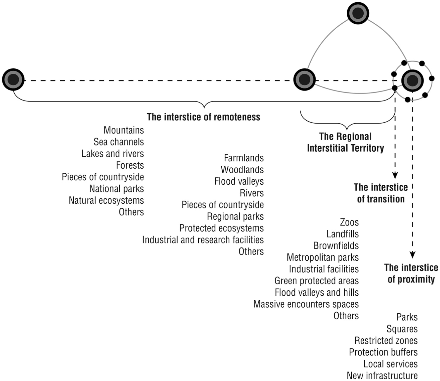
Four geographic scales of interstitial space.
Interstices of proximity within suburbs define a first scale in terms of their closer relation to the urban core or other existing urban fragments. This scale of interstitiality is most clearly visible in monocentric cities and towns, whose most rapid urban expansion has already passed, or in economically less dynamic urban systems. The set of possibilities embraces the likes of parks, squares, protection’s buffers and some restriction zones, local services and infrastructure often in inner suburban locations.
Interstices of transition are those where un- or under-developed spaces help define the character of contemporary urban expansion within a metropolitan system. At this second scale, the ‘interstitial territory’ presents a multi-level issue for governance, implying a need for coordination across different policy sectors and municipalities most commonly in a monocentric metropolitan context. This is the case of metropolitan parks, military facilities, zoos, industrial and research facilities, bigger restriction zones such as landfills and brownfields, green protected areas or ecosystem features such as flood plains, valleys or hills. Spaces such as Cerillos Airport can appear particularly relevant to the very largest international developers and governments alike if they are of sufficient scale, well-located and easily accessed (Silva, 2015, 2017b). Less benignly they can be locations at which to ‘dump’ social and environmental impacts near and beyond the boundaries of local jurisdictions as we will see in the example of extraction sites across Santiago de Chile.
The spaces between different settlements as part of an urbanised region define a third scale of the ‘regional interstice’ which implies a correspondingly wider coordination across policy sectors and municipalities and a wide array of special purpose authorities related to agriculture, industry, environment and public works. This scale perhaps pertains more to polycentric urbanised regions and embraces vast areas between two or more independent cities. This is the scale of interstitial space that Scott (2012: xi) sees having significant economic potential in the cognitive-cultural economy where ‘restructuring effects in many of the interstitial spaces between large cities … significantly redefine what it means to be rural’. These regional scale interstices appear important in the USA but also in Europe such as in the Randstad of the Netherlands.
Interstices of remoteness are the largest non-urbanised areas that lie between different heavily urbanised regions. Most of the interstitial spaces defined at this scale are connected to national planning policies and environmental designations such as national parks, protected ecosystems and large geological and topographical features such as mountains, lakes, estuaries.
The different scales at which interstitial spaces appear also have ramifications for extant theories of urban politics. The smaller and often more constrained interstitial spaces found at the scale of proximity are more likely to represent the piecemeal opportunities distributed within urban regime-style politics (Stone, 1989). For some of the reasons outlined by Phelps and Wood (2011), those larger and less constrained greenfield interstices found at the scales of transition and region are more likely to be subject to growth machine politics (Molotch, 1976).
Pending space: Economic, social and environmental values adhering to interstices
Interstitial spaces have their own temporalities which rarely figure in extant theories of urban politics. Growth machine theory (Molotch, 1976), for example, speaks to situations of urban growth and rather assumes that the land development process continues unabated because of the coincident interests among local government and the private sector. However, even under conditions of urban growth, the competing economic, social and environmental values adhering to interstitial spaces ensure that some spaces – including the largest and most desirable to the private sector – can be pending for prodigious periods. This is certainly the case with the former Cerillos Airport site mentioned above where the continuing delay in the development of this prime site is partly attributable to a clash of urban models – between suburban ‘business as usual’ for developers and the opportunities perceived by urban planners for experimentation with new models based on global narratives of urban sustainability, smart growth and the like (Silva, 2015, 2017b). Even in contexts of urban growth, recessions mean that numbers of interstitial spaces vary cyclically in the short-term, presenting opportunities for interim uses (Kamvasinou and Roberts, 2014). In contexts of urban shrinkage, the number of interstitial spaces will likely be in long-term increase. The impacts of temporary or interim uses on the empowerment of social groups, landowners and planning policy as a result of both short-term and long-term increases in numbers of urban interstices should not be underestimated (Kamvasinou and Roberts, 2014: 197).
Another case in point here would be three notable privately owned and operated spaces of extraction activities in Santiago de Chile. Figure 3 shows a large site pock-marked from the extraction of sands and gravels at the boundaries of the Maipú, Cerrillos and Estación Central communes. Extraction in each case has dwindled to a now negligible activity alongside some very minor construction-related activities in spaces that are classed as industrial land but are effectively now interstitial spaces. As decaying or blighted spaces they are nevertheless also ‘pending’ spaces framed by variable timelines over which they may become developed in some form or other, not least because of the active attempts by their owners to promote them for new development.
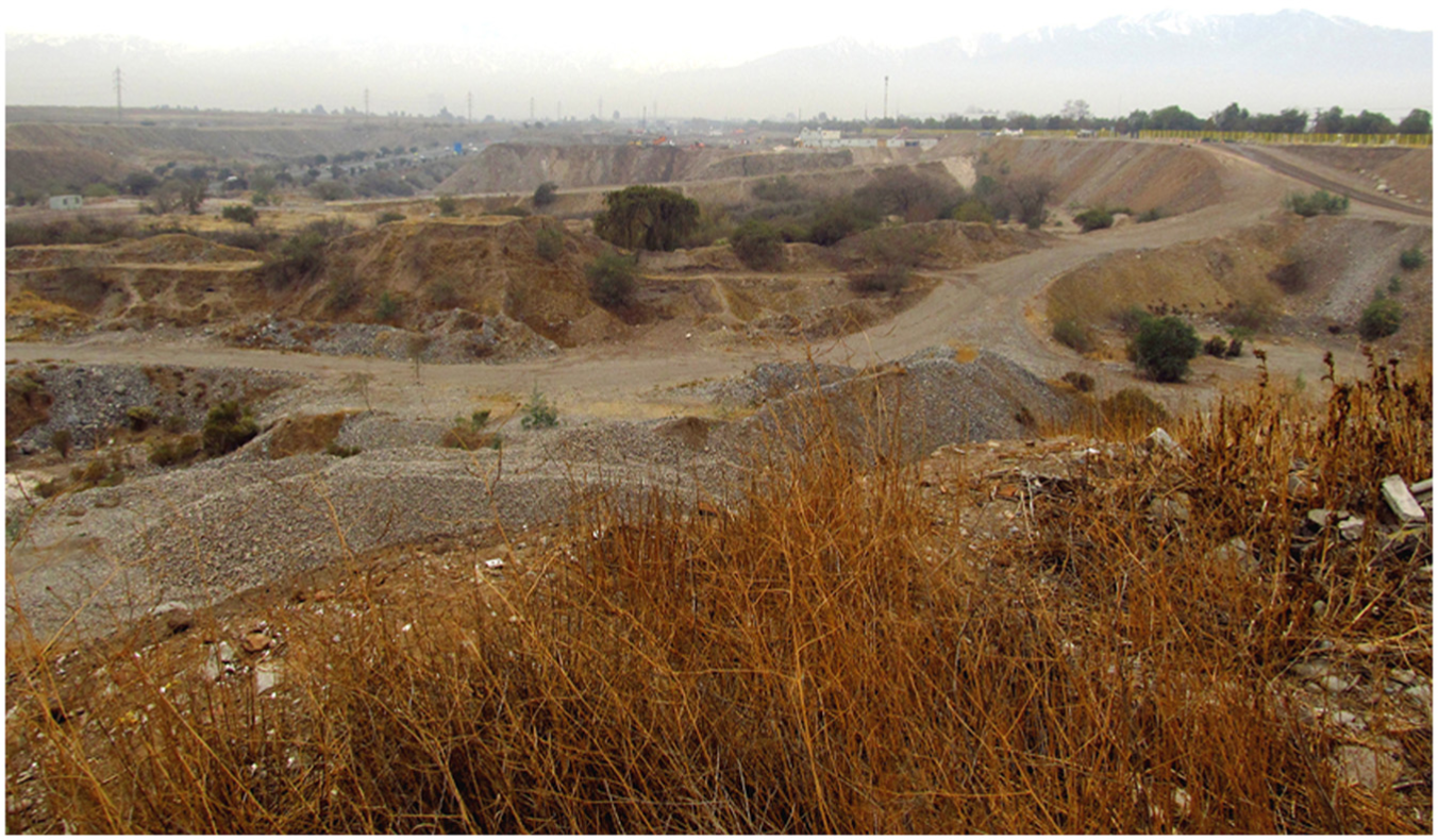
An extraction site in the commune of Cerrillos.
The term terrain vague (Careri, 2002; Choay, 2003; Sola-Morales, 1995) emphasises the temporal ruptures in the urban fabric – the pending character of interstitial spaces. Interstitial spaces at different scales are also subject to different temporalities in their existence. The literature on fringe belts (Whitehand, 2001; Whitehand and Morton, 2004) reminds us that the development of interstices can be pending over prodigious lengths of time. That is, interstices appear inevitably as part of the sequencing of the development process (Peiser, 2001: 282). Indeed, for Brighenti (2013: xvi), an urban interstice is a space ‘surrounded by other spaces that are either more institutionalized and therefore economically and legally powerful, or endowed with a stronger identity, and therefore more recognizable or typical’ (Brighenti, 2013: xvi). In this regard the past productive value of brownfield land (Hebbert, 1986; Yeh and Li, 1998) appearing as interstices within urban sprawl has been recognised. Likewise the future potential productive and speculative economic value of interstitial spaces of urban sprawl has often been highlighted in passing. Farmlands appeared as ‘pending lands’ in the process of land conversion in the USA (Clawson, 1962: 102). Open spaces – perhaps as a function of leapfrog patterns of development – in suburbs are actually central both to strategies by developers to increase the yields from residential development (Thomas and Walsh, 2004) as Hovinen (1977) and Neuman (1997) describe in the case of the USA and Spain. They can also be important to residents in the enhancement and maintenance of property values.
These sorts of problems fall into sharper relief in developing countries where economic asymmetries present difficulties in terms of balancing urban growth and service provision. According to Ige and Atanda (2013) urban growth in developing countries has not been driven by proportionate increases of services, facilities and efficient urban management. Here urban sprawl has led to the presence of isolated, haphazard and incidental vacant spaces with negative consequences for, and degradation of, the urban environment, such as informal occupations, scenes of uncollected garbage and the infilling of vacant spaces and parks or other encroachments (Ige and Atanda, 2013: 29). The aforementioned description draws a picture of interstitial spaces as ‘unexpected’ negative externalities where the urban growth machinery produces outcomes as part of regulatory processes that are asymmetrically disposed towards economic development.
However, the pending nature of interstitial spaces is also registered in their latent social, environmental or ecological value. Brighenti (2013) focuses significantly on the possibilities presented by urban interstices for the mobilisation of minority populations and interests. Gandy (2009) used the term ‘interstitial place’ to define areas inside the city as ‘wild’ lands fully charged of natural characteristics and repositories of information that encompass micro-climates, flora and fauna and geology. Gandy stresses their potential when noting how they: ‘reveal a city within a city that is not stage-managed for tourism or consumption but open to multiple alternatives; a network of unregulated spaces between both ecological and socio-cultural diversity can flourish’ (Gandy, 2009: 152). He has since gone on to define these unintentional landscapes as involving ‘an aesthetic encounter with nature that has not been purposively created’ (Gandy, 2016: 434).
Yet the pending character of interstitial spaces is also something that has important ramifications for a grassroots politics of collective consumption. In Germany, for example, the temporary or interim uses of the vacant sites – or Zwischennutzungen – that have proliferated with urban shrinkage are dependent on a new urban politics (Dubeaux and Sabot, 2018). In this way, urban interstices are spaces to be appropriated as new commons for new social practices (Stavrides, 2014). Yet they can also be revealing of important fissures that can exist within the politics of collective consumption (Castells, 1977) – a subject that urban political theory has perhaps been slow to acknowledge. Interstitial spaces can be the subject of competition between different collective consumption needs. Gottlieb (2007: 54) notes how the remaking of nature in the vacant spaces of Los Angeles has also rubbed up against desires to use such spaces for other collective consumption needs such as schools, social housing and waste treatment facilities.
The planning and non-planning of interstices
The physical, legal, planning and regulatory characteristics that shape the pending nature of interstitial spaces of urbanisation suggest that interstitial spaces are the deliberate result of ‘corporate and institutional reserves’ (Northam, 1971). Yet, in other instances, urban interstices appear as the unexpected outcomes of planning.
On the one hand, some interstices are the expected outcomes of the planning process. Vacant lands present important environmental properties within the whole process of urban expansion but there are substantial contrasts in this role across a range which encompasses city centres, inner suburbs outer suburbs and peri-urban areas (Douglas, 2008). Most green spaces in inner city and inner suburban locations are protected and seldom changed (private gardens, private community squares, or small parks nearby). Yet, brownfield interstitial spaces in the same inner city locations may be subject to planning ‘blight’ despite their latent economic value. Here any growth machine logic is one in which local and national state expenditures rather than purely private interests may come to the fore (Phelps and Wood, 2011). The ‘rent gap’ associated with derelict or unused land and properties (Smith, 1982) may not close without planning intervention (to clean up or provide access to sites) and even then may necessitate an urban politics and planning permissive of informal, temporary or interim uses where decline is prolonged (Dubeaux and Sabot, 2018). In the outer suburbs and peri-urban areas, more land-use change occurs mainly because ongoing development pressures are more intense. Here development may proceed and open spaces disappear because of the conversion of remaining raw land into developed land for the first time. While nature is often uprooted with vegetation removed or new species imported, the green spaces that are left or which were created in the development process will also retain a value in terms of their potential biodiversity and their ecosystem services (Douglas, 2008: 1113).
Interstices are planned as ‘open’ in order to sustain their environmental properties, create security zones or to create public spaces at different scales. These are the cases of green corridors, security buffers, parks and squares. These ‘vacant’ lands are expected to provide positive externalities and often are secured under planning regulations. In this context, architects and designers have designated open spaces as ‘buffers’ between different incompatible functions such as industries and residences, for instance. Yet, in this way Talen (2010) argues American zoning contributes to sprawl, since open spaces seem to be randomly distributed over the area of urban expansion, not because of their potential as public places but rather because of the importance of several previous infrastructures: ‘There are many examples of this phenomenon, such as residential zones adjacent to eight-lane freeways, and public amenities surrounded by low-density, single-family zoning. In most cases, a more appropriate spatial pattern would put open space or more resilient uses adjacent to freeways, and higher-intensity land uses adjacent to public amenities’ (Talen, 2010: 179). Thus, open areas are also ‘planned’ as vacant lands for absorbing impacts and protecting new development; the emptiness of these buffers is defined in their roles as urban containment mechanisms.
On the other hand, interstices can appear unplanned as the unexpected outcomes of planning systems, produced as a consequence of the appearance of other developed areas, economic constraints, geographical handicaps or declines in the market value of land and properties. This is the case of empty spaces between two large-scale residential neighbourhoods, derelict areas, a flood valley or brownfields which have been left inside the urban territory with its expansion. Often these spaces are encroached on by informal activities and might be viewed as negative externalities. Private-sector inertia contributed greatly to a ‘paradox of extreme land vacancy coexisting with supply constraints in inner urban areas’ (Adams et al., 1994: 14) in land coming forward for industrial development in the Wirral area of the UK in the 1980s. Here, planning was not the main constraint on the development of sites while planning authorities as land owners were often more active in bringing forward sites for development than private-sector owners.
Interstitial spaces appear unplanned to the point where architects, urbanists, planners and other professionals work on them in an attempt to fill and stitch them together with new forms of order (Matos, 2009: 63). Indeed, paradoxically, they may represent those spaces within the urban fabric most free from authority (Careri, 2002). In this light, the planned condition of interstitial spaces often emerges as a matter of revamping in order to host flagship developments in which success rests on urban design practices and politically oriented regulations that reinforce them. The revamping process of a former large-scale suburban interstice in Santiago de Chile defined by a former airport has been all about urban design issues and morphological patterns as tools to integrate the area into the surrounding urban fabric. However, the unplanned framework for decision-making has left design procedures in a long-standing stalemate in which politics pervades all aspects of the efficacy of planning approaches (Silva, 2015, 2017a). Curiously, as a result, this intensely planned interstitial space still projects an image of desolation (see Figure 4).
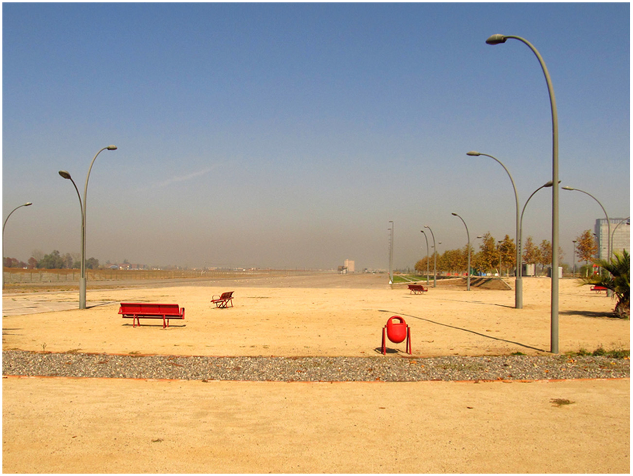
Forlorn urban design elements at the site of a former airport in the Cerrillos commune.
Finally, some of the major ingredients of sprawling suburban landscapes, although planned and although apparently placeless, have had unintended or unanticipated consequences. ‘In the same way that many organizations change or grow as a result of their own eccentricities, the production of spatial commodities is fuelled by mistakes and risks’ (Easterling, 1999: 4). The generic production of spatial commodities that Easterling is referring to concerns mass suburban housing but also the likes of highways and other infrastructure which signal the relational properties of some interstices – a subject to which we turn now.
The relationality of interstices
Interstitial spaces are revealing but paradoxical sites of relationality. Not only are urban interstices less relational than they might be when the infrastructures associated with these spaces are discrete and non-connecting (Easterling, 1999) but those infrastructures can also interrupt the erstwhile relational potential of adjacent built spaces and communities inhabiting them. Moreover, the relational potential of urban interstices exceeds the territorial purview typical of extant theories of urban politics.
As infrastructure-rich spaces, interstices have been considered prime instances of placelessness (Relph, 1976: 90). These non-places can be quantified ‘by totalling all the air, rail and motorway routes, the mobile cabins called “means of transport”’ (Augé, 1995: 79). The heightened mobility associated with such infrastructures can appear ‘to involve a number of absences – the absence of commitment and attachment and involvement – a lack of significance’ (Cresswell, 2006: 31). Yet, in contrast to the absences that might be associated with infrastructures of mobility, Vidal’s discussion of the interfragmentary spaces made up of infrastructure networks highlights their relational properties. This property of inter-fragmentary space is one that results from of an overlapping between fragments, the suturing of urban fragments and the creation of networks of action (Vidal, 2002: 152). Vidal defines the ‘inter-fragmentary space’ of networks for cases of urban fragments which are physically separate but connected by lines, channels, mains, pipes and other elements concerned with promoting movement. 4
The commune of Pedro Aguirre Cerda within the metropolitan area of Santiago de Chile has several infrastructural interstices that appear at its boundary. These interstices emerge as physical divisions and restricted areas and although this intensive provision for mobility might signal significant regional economic potential, it nevertheless is perceived as negative because these spaces do not afford easy access to pedestrians and to nearby employment sites. Moreover, in extreme instances, such as seen in Figure 5, the network attributes of these interstitial spaces can be seen to contribute to their indeterminacy – since infrastructure components can describe different degrees of functionality and effectiveness coexisting in the same interstitial space. The motorway, for instance, might be seen as an efficient and modern infrastructure coexisting with the now less functional railway as the heritage of the former prime mode of transport of commodities. These two share an interstitial space in which a polluted canal is used to evacuate industrial residues but hardly offers a safe, let alone amenable, artery for connection.

Different networks mingle at the boundary of Cerrillos and Pedro Aguirre Cerda communes.
The term green infrastructure carries with it a sense of how interstitial spaces are forces for the integration of urban territories. The network infrastructural properties of the interstices of urban sprawl are also implicit in Sieverts’ emphasis on the conflicts over major public works in the zwischenstadt. Indeed, Keil and Young (2011) and Young and Keil (2014) have used the concept of zwischendstadt explicitly to draw attention to the expanses of in-between suburban landscapes which are crossed by infrastructure. These places, traversed by roads, are also potential expansion areas (Keil and Young, 2011: 9). Yet their relational properties are rarely fully mobilised. The vulnerabilities of populations of in-between cities in the Canadian case have been produced ‘by the failure of conventional political spaces and processes to capture the connectivities threaded through those places that are in-between the centre and exurbia’ (Young and Keil, 2014: 1590). Here it is as well to remember that ‘the spatial imaginary of land use planners remains largely bounded within their own municipal territories, contra the global talk that characterizes most discussions of logistics and distribution’ (Cidell, 2011: 845).
Conclusion
Fragments of writing found notably in architecture, art and literature studies and, to a lesser extent, urban sociology, planning and geography focus on interstitial spaces explicitly but often for quite particular purposes. Here we have incorporated their insights into a research agenda that hopefully resonates across the broader field of urban studies. First, many of the existing terms that speak to urban interstices are suited to analysis at particular geographic scales. We therefore proposed a definition of the term interstitial operative at different geographical scales. For the purposes of analysing the un- or underdeveloped spaces that necessarily are part of urban sprawl in particular, we drew attention to two scales as the most pertinent: the interstices of transition and interstices at the urban regional scale. Second, the interstitial spaces of urban sprawl are not inert. They are comprised of a wide variety of uses and activities. Consideration of the function of interstitial spaces is well covered in the extant literature and we focused instead on important meanings attached to, and forces operative on, interstitial spaces. Interstitial spaces can be read in terms of historical processes which render them pending. Such potentials are most obvious with regard to the economic interests at play and that most forcefully suggest the inevitability of their transition to developed land. Nevertheless, there can also be important environmental, social and political meanings and potentials invested in such spaces. Some of these have come to the fore in the remaking of urban nature (Gottlieb, 2007) and the politics of collective consumption. Third, the potential of interstitial spaces is apparent regardless of whether such spaces are regulated or not. Planning policies and regulations ensure a degree of permanency and functionality of some interstitial spaces. Paradoxically, however, planning and regulation of land use can lend the appearance of urbanisation being unplanned. The term ‘planning blight’ suggests not an absence of planning but the vulnerabilities of planning processes to economic and political cycles. Fourth, to the extent that the term interstitial space can encapsulate relationships between spaces within urban sprawl it may also prove to be an integrative term. It can serve to integrate discussion of both the developed and un- or under-developed spaces that compose the urban; the infrastructures and regulatory activities and designations that link both; the economic, political and social groups that occupy, identify with, and seek to operate upon both.
This agenda highlights the value of integrating insights from different disciplines of the built environment. The literature on fringe belts and expansion zones figured prominently at one time in geography. The work of planners provides important insights into the effects of regulation on the scale and pending nature of interstitial spaces. The ideas of zwischenstadt and interfragmentary space promoted by architects have drawn attention to the regional and architectonic scales at which interstitial spaces are apparent and their relational properties. Politics, as we indicated in the examples drawn from Santiago de Chile, is never absent from the fortunes of urban interstices and as such the four themes around which we organised our discussion each have implications for extant theories of urban politics.
In this latter regard, interstitial spaces are ones that speak to scalar and relational ontologies of the urban. It may even be more apposite to ask the question ‘whose city?’ of interstitial spaces given the competing interests surrounding them. Interstitial spaces highlight the inseparability of analytical perspectives and normative agendas on urban dynamics as much as the built environment. The susceptibility of interstices to both scalar and relational ontologies calls for the development of theories of urban politics beyond the city or the urban as a single undifferentiated unit.
Footnotes
Funding
Funding was received from the Ministerio de Educación, Gobierno de Chile, Comisión Nacional de Investigación Científica y Tecnológica (project code 72110038).