



Abstract
Recent research indicates that a simplified approach to urban planning in Sub-Saharan African cities can address the challenges of rapid urban growth. Current plans focus too heavily on the existing area of the city and offer unrealistic agendas for future urban growth, such as densification, containment and high-rise development; plans that are often too complicated and too costly to be deployed in a developing-world context. In response, New York University and the Government of Ethiopia have created a programme to deploy a simple methodology called Making Room for Urban Expansion in 18 Ethiopian cities that are experiencing rapid growth. The programme is called the Ethiopia Urban Expansion Initiative. The Initiative set aside a number of standard planning objectives and instead focused only on expanding city boundaries to include adequate land for expansion, designing and protecting a network of arterial roads spaced approximately 1 km apart, and identifying and protecting environmentally sensitive open spaces. These efforts focused on areas that had not yet been occupied by development. This article reports on the preliminary results from the four Ethiopian cities participating in the Initiative that began in 2013. The results from the first four participating cities show that simple plans can lead to the creation of new arterial roads, increasing access to peripheral land and potentially bringing the available land supply in line with projected growth. These activities can be done at the local level and implemented with limited support from consultants and from the regional and national government, and it requires minimal public investment.
Introduction
New research based on the analysis of satellite imagery shows that the typical Sub-Saharan African city grew at least three-fold in area between 1990 and 2014. Over approximately the same time period the urban population doubled, increasing from 19% to 38% of the total population (UN Habitat, 2014). The UN Population Division estimates that 55% of the population of the region will live in cities by 2050. In fact, almost one-third (32.6%) of worldwide projected urban population growth between 2015 and 2050 will occur in Sub-Saharan Africa, tripling the region’s urban population over the coming 35 years (United Nations, 2014). During the same period, the typical African city will at least quadruple in area.
However, these cities are doing a poor job of preparing for the arrival of their new residents. The recently released Atlas of Urban Expansion: 2016 Edition (Angel et al., 2016) reveals that as much as 78% of the residential areas developed between 1990 and 2014 in Sub-Saharan Africa were informal and unplanned. Only 73% of newly developed areas were found to be within walking distance of an arterial road. When comparing Atlas findings by region, Sub-Saharan Africa stands out as particularly deficient, pointing to a critical gap in spatial planning methodologies (Watson, 2002), implementation frameworks (Berrisford, 2014; Hyden, 1983) or both.
The need for quality spatial planning is made all the more urgent by the high poverty rate on the continent, and the geographic reality of economic development – that the majority of non-subsistence, non-resource extraction economic activity in Africa takes place in cities (Mabogunje, 1990), that potential economic returns in cities are higher than in rural areas (Collier, 2013) and that personal incomes in cities are often several times higher than incomes in rural areas (Sahn and Stifel, 2003). To leverage this, cities must promote the formation of functional metropolitan labour markets by designing efficient transport networks at an appropriate scale (Angel and Blei, 2016), while also preserving livability and environmental sustainability by protecting a network of public open spaces.
Unfortunately, much of the planning that takes place in African cities today fails to tackle these issues in a way that addresses the unique difficulties these cities are facing – a combination of high rates of growth, low levels of income and poor rule of law (UN Habitat, 2014).
Watson (2002) notably highlighted the breakdown between urban planning theory and urban planning practice as one possible cause of the ongoing problems in Sub-Saharan Africa. Hall and Tewdwr-Jones, (2010) echoes the critique, describing theorists as trapped in the ivory tower, and practitioners as isolated and hamstrung. Watson’s solution is simple: planners must collaborate with theoreticians in the production of in-depth case studies. This article moves beyond that call, reporting on the results of a partnership in which a major university (New York University) partnered with a national government (Government of Ethiopia) to assist local planners in testing and implementing a new methodology. This methodology, entitled Making Room for Urban Expansion (Angel, 2012), is the basis of two active programmes – the Colombia Urban Expansion Initiative 1 and the Ethiopia Urban Expansion Initiative.
Making Room for Urban Expansion consists of a simple four-point programme:
The preparation of realistic maps based on forecasts of urban growth for the next 30 years;
The expansion of city boundaries so that the land necessary for that growth is under the control of one planning authority;
Securing land for a 1 km x 1 km grid of 30-metre-wide arterial roads; and
The selective protection of a hierarchy of public open spaces in the expansion zone.
Given immediate and pressing needs and a scarcity of resources to devote to future planning, there are good reasons for cities to prioritise these activities above most others. The city must have accurate projections of future urban expansion and the authority to reserve land if they are to provide public goods. Open spaces and arterial roads are critical examples of such public goods. If the process of securing them is to be affordable and equitable, the work of securing land must be completed before development occurs, when population densities are lower and land uses are less intense.
In general, Making Room for Urban Expansion emphasises physicalist planning, and is grounded in the knowledge that poor communities are often well equipped to provide their own housing, as long as they are given the time and the legal protections to engage in incremental development. The creation of an orderly grid of streets and roads and a hierarchy of public open spaces will ensure that even informal developments are part of a framework that will eventually be normalised and serviced (Angel, 2012; Baross and van der Linden, 1990). It will also cheapen the installation of public transport and trunk infrastructure, place most residents within walking distance of a road that can efficiently carry public transportation, and encourage a functional metropolitan labour market by making all areas of the city accessible to residents seeking employment and services.
Making Room for Urban Expansion in context
It is neither novel nor particularly innovative to call for the deployment of an unadorned orthogonal grid of large roads. Such practices can be traced back at least to the Greek philosopher Hippodamus (Kolb, 1984, quoting Morris, 1972), and most likely back to the Egyptians of the third millennium BC (Dalley, 1989). The notion of using planning to protect environmentally sensitive public open spaces is also a relatively old idea, perhaps traceable to Ebenezer Howard’s Garden Cities (Hall and Tewdwr-Jones, 2010).
The call for a revival of this planning tradition has to do with the desire to empower local planners to address the urgent problems of poverty, inequality, informality, rapid urbanisation and spatial fragmentation, as Vanessa Watson calls for in her 2009 paper ‘Seeing from the south: Refocusing urban planning on the globe’s central urban issues’ (Watson, 2009a). With this approach, we hope to answer a fundamental question within the discipline of urban planning: what can urban planning do to help poor, rapidly growing cities?
A review of contemporary planning practices, both in the literature (Buckley et al., 2016; Okpala, 2009; Watson 2009b) and as expressed in completed plans, indicates that the answer today is, ‘Nothing, or at best very little’. Many earnest efforts are being made to create the African cities of tomorrow, but they are having far less of an impact on the ground than is needed. A recent article posited that cities in Africa could be falling victim to ‘Ozymandias Syndrome’ (Buckley et al., 2016), pursuing fantastical creations at the expense of more modest but more meaningful improvements. While this is no doubt true in some cases (Nova Cidade de Kilamba, for example (Buire, 2015)), the bigger story is more mundane. In Nairobi, Kenya, for example, planners worked with the Japan International Cooperation Agency (JICA) for seven years to produce an updated master plan, completed in 2014 (the original plan, from 1973, expired in 2003). Unfortunately, the new Nairobi Integrated Development Master Plan is so complex that the designers themselves are concerned it will be impossible to implement (Nippon Koei Co. Ltd., 2014). This is not an isolated anecdote – similar situations have been reported in Lagos, Nigeria (Hedrick-Wong and Angelopulo, 2011) and in Tanzania (Watson 2014), and anecdotal evidence indicates that many more African cities are either ‘muddling through’, with minimal attention to long-term needs, or are counting on dubiously effective and overly complicated Comprehensive Master Plans. The result in both cases seems to be similar – cities are growing chaotically, without enough land for streets, without adequate arterial road networks and without an orderly layout of the territory.
In the past, many cities designed and implemented the same kind of plan that is proposed in this article – a simple plan that uses public lands to organise the space available for urban development, while still allowing the market to function (Glaeser, 2011). In those years there was no such thing as a Comprehensive Master Plan, and yet cities thrived. The simple plans work by connecting the city together and by making room for new residents through the provision of public goods.
It seems, then, that securing an orthogonal grid of roads and protecting environmentally sensitive spaces sounds novel simply because no one today is doing it, as former UN Habitat Executive Director Joan Clos has stated. 2 Perhaps one reason why this style of planning has fallen out of vogue is because it leaves out too many elements that are seen as essential. But a basic and achievable plan is better than a comprehensive plan that cannot be implemented, and is clearly better than no plan at all. This article presents results showing that a simple plan can quickly produce outcomes on the ground, and that even the poorest cities can afford to make and implement this plan, in the face of considerable challenges.
A specific focus on Sub-Saharan Africa is appropriate because of the vast increase in urban population that is expected there, combined with a very low level of public sector capacity and a correspondingly great need for well-functioning and productive environments for people to live and work in. Although there is some variation among different cities, the authors believe that this is the case throughout the region. Making Room for Urban Expansion is a planning philosophy that is fundamentally about supporting local planners in addressing these challenges. A paper issued by the Africa Research Institute asked, ‘Who will plan Africa’s cities?’ (Watson and Agbola, 2013). The answer we offer is an emphatic, ‘Africans!’ – but only if they have the tools to do so.
The Ethiopia Urban Expansion Initiative
Ethiopia stands out as a country that is both rapidly urbanising and particularly impoverished. The share of the population living in cities has increased from an estimated 7.1% in 1994 (Schmidt and Kedir, 2009) to 16% in 2008 (FDRE, 2008), and is expected to reach 60% by 2040 at the current annual growth rate of 3.5% (United Nations, 2014). In other words, the next three decades are the ones in which Ethiopia will be building its cities – cities with which it may then have to live for many generations. Ethiopia faces this daunting task as one of the poorest countries on earth, with a per capita GDP of less than US$600 – far below the 2014 average in Sub-Saharan Africa (excluding South Africa) of US$1699.
The GoE has identified urbanisation in secondary cities as an important pole in its Growth and Transformation Plan II, which has a primary target of raising the national GDP to lower-middle income status by 2025 (FDRE, 2015). Formal urban expansion in most cities relies on a system of auctioning leases for serviced urban plots in new Local Development Plans. However, this system has proven to be fiscally untenable and has not been able to deliver land at scale (Kaganova, 2014; World Bank, 2016). It is difficult to measure the exact gap between supply and demand, but in Bahir Dar, for example, residential land was sold for US$380 per square metre at a recent auction – more than half the per capita income. However, the current system is well-designed to produce arterial roads and public open spaces.
All land in Ethiopia is owned by the state, and occupants hold long-term leases. As a result, the government has broad authority to obtain land for public purposes, with compensation paid based on a multiple of the production value of the land, plus the value of structures and other amenities. Leaseholders have the option to protest the amount of compensation. Ethiopian law also has a procedure for land reconstitution and the realignment and recording of plot boundaries, as part of the regularisation of informal settlements. 3
Scarcity in the formal sector means that urban land in Ethiopia is almost exclusively provided by the informal sector. The standard practice of the Ethiopian government is to regularise informal settlements within three years of their construction. In Hawassa, for example, 17,920 illegal settlers have been regularised in the past year. When households are regularised they are given a lease document that entitles them to city services, and they are expected to make regular payments for the duration of the lease. In essence, this circumvents the onerous requirement that plots be acquired and serviced before they are leased. Cities also use the regularisation process to adjust informal plot boundaries into a more orderly layout, something that we have documented in Hawassa in particular.
One common concern expressed by city officials is that laying out an arterial grid for urban expansion will simply encourage more of this informal development by making land more accessible. This is highly likely, but officials close to the programme believe that the newly developed areas will be more orderly and easier to eventually formalise.
In 2013, New York University (NYU) hired Dr David DeGroot, former leader and originator of two major World Bank capacity building programmes in Ethiopia (PSCAP and ULGDP I & II), to explore the possibility of assisting the Government of Ethiopia (GoE) through the creation of the Ethiopia Urban Expansion Initiative (UXI), which would implement the Making Room for Urban Expansion strategy.
His exploratory work focused on site visits to assess the interest and capacity of municipal governments to undertake the necessary tasks, with an eye toward selecting several pilot cities. Meetings were held with officials from the Ministry of Urban Development and Housing (formerly MUDCho and currently MUDH) to outline how the proposal would connect with the national-level urban sector plan. In addition, NYU researchers provided population growth rates and spatial growth rates for candidate cities. Ultimately, a decision was made to engage four rapidly growing regional capitals in a two-year pilot project, with technical support costs to be borne by NYU and implementation costs to be borne by the various levels of government, including the municipalities.
This arrangement was confirmed through a Memorandum of Understanding (MOU) between the two parties that established the basic organisational structure of the project – NYU and the GoE. NYU hired and deployed international consultants to support the cities in creating and implementing the plans. The consultants provided training in the theoretical foundation for the work and helped resolve common misunderstandings about the programme. NYU also deployed faculty to conduct an initial workshop and to support the participating cities. Additionally, the faculty helped establish a course in the methodology for civil servants, first at the Ethiopia Civil Service University, called Planning for Urban Expansion. To support the cities between visits, NYU engaged a part-time country coordinator. NYU also funded a portion of the cost of project-related city visits by top MUDH officials, paid honorariums to local staff and covered local travel costs for local officials.
MUDH helped each city form ad hoc urban expansion teams within the existing urban or land management bureau. Each team consists of an engineer, an urban planner, a finance expert and an environmental expert. The expansion teams are assigned a local champion, either the mayor or city manager. Each team functions as a special project group within the bureau, responsible for drafting and implementing the 25-year plans based on the projections provided by NYU consultants. Previously, planners focused on five- to ten-year structural plans, implemented through neighbourhood-level LDPs. This has not changed, but the structural plans are now part of a longer-term vision for the city, with 2040 established as the new planning threshold. The teams are supported by officials at the MUDH.
Eighteen cities are now participating in the Urban Expansion Initiative (UXI) (Figure 1). The initiative started with a Phase I group of four cities – Hawassa, Adama, Mekele and Bahir Dar. It then expanded to include a Phase II group that used the same methodology and strategy, with additional assistance provided by the regional universities. Both groups of cities were selected based on three criteria, following recommendations from the MUDH:
They could not be the primary city in the country;
They had to have populations greater than 100,000; and
They had to be growing at 3% per year or higher.
This article reports on the progress made in these first four cities. Adama is no longer participating in the programme, for reasons that are discussed later in this paper (it may eventually rejoin). It should be noted that this paper is in the form of a progress report. The programme under consideration is slated to continue for a further 23 years, so any final assessment would be premature.

Eighteen cities participating in the Ethiopia Urban Expansion Initiative (Phase I cities with triangles, Phase II cities with circles).
Falling density and rapid growth
Projections prepared by NYU and provided to the GoE forecast remarkably rapid growth for these four cities between 2010 and 2040, with the cities expected to more than triple their 2010 population by 2040: Hawassa will grow to more than six-fold its 2010 population by 2040, Mekele to almost five-fold its 2010 population and Adama and Bahir Dar to almost four-fold their 2010 populations (see Table 1).
Projected increases in the population and built-up areas of four rapidly growing Ethiopian cities, 2010–2040, assuming a 1.5% annual increase in built-up area per person.
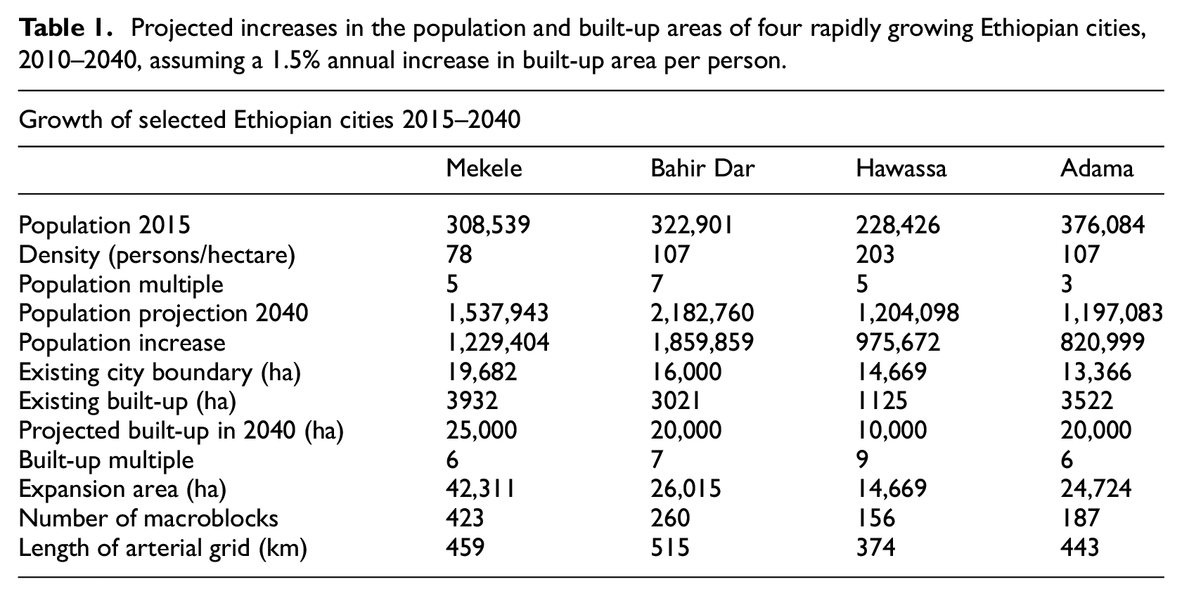
The built-up area of these cities is predicted to expand at an even faster rate than their populations. This conclusion takes into account the findings of the 2010 Atlas of Urban Expansion (Angel et al., 2010). In general, the Atlas of Urban Expansion 4 found that the built-up area per person (the inverse of ground-level population density) in a sample of 120 cities grew, on average, at 2% per year between 1990 and 2000, and 1.5% per year in a smaller sample of 30 cities between 1800 and 2000. It was therefore conservatively estimated that the built-up area per person in Ethiopian cities would grow by 1.5% per year.
Based on this method of estimation, the built-up area of the cities will grow quite dramatically: Hawassa by almost nine-fold, Bahir Dar almost seven-fold and Adama and Mekele by around six-fold, in comparison with the 2010 built-up areas (Table 1). The historical expansion and future expansion of Mekele can be seen in Figure 2, for example. Even given a large margin of error, the numbers speak to the need to prepare for expansion. Furthermore, the historical expansion rates of other rapidly growing cities indicate that the rates proposed are not unrealistic or unreasonable.
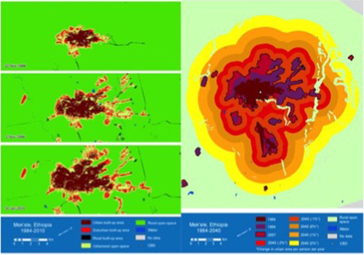
The expansion of Mekele from 1984 to 2010 (left) and 2040 (right).
Plan development
NYU provided information on the expected expansion of these cities to the MUDH and the municipalities in March 2013. These sorts of estimates allow cities to determine the approximate order of magnitude for their plans. Actual construction of infrastructure does not take place until shortly before development reaches a given area, so the opportunity cost of overestimating the amount of growth is low, particularly when compared with the danger of making plans that underestimate the total amount of growth. 5
The urban expansion teams used these projections to produce preliminary plans. Officials had workable draft plans ready in only three months, and NYU organised a workshop in July 2013 to allow the cities to present their plans to regional government representatives and MUDH.
The July 2013 workshop established the template for future NYU engagement with the cities. The workshop had four objectives: to educate practitioners and policymakers on the research and philosophy behind the planning strategy; to assist the cities in sharing their plans with relevant policymakers at higher levels of government; to improve the plans through expert criticism and collective input; and to strategise about necessary next steps. Former minister Haile Mekuria used the first workshop to formally launch the project, underscoring its importance.
The expansion plans presented at the workshop were conceptual and structural, calling for a 30-metre wide grid of arterial roads, spaced 1 km apart and occupying an average of 8% of the land in the expansion zone. The cities agreed to divide these plans into phases, with each phase scaled to accommodate five years of growth. Road development would start with a detailed engineering survey of the roads, followed by payment of compensation to landowners, demarcation of the edges of the right of way and, finally, construction of a simple road. General plan figures are contained in Table 1.
The main finding from these plans was that the area needed for expansion was generally larger than the area under the control of the city administration. To remedy this and ensure consistent implementation of the spatial plan, the regional governments agreed to convene the woredas, rural local authorities, to agree on a plan to expand the planning jurisdiction of the cities. The woredas, already facing significant urbanisation but lacking the resources to provide urban services, agreed to the plans for expansion, and new city boundaries were approved in November 2013 (Figure 3).

Images prepared by Mekele city administration showing original (dark) and expanded (light) city boundary.
Additional workshops followed in November 2013 and February 2014. These were focused on swiftly estimating compensation costs for budgeting purposes, and preparation and presentation of more detailed plans and budget proposals for Minister Mekuria and the regional bureau heads. The plans were approved, but city officials noted that funding was insufficient to meet plan targets.
The creation of an arterial road grid
Cities received first-year budget allocations in mid-2014 and began paying compensation to landowners and constructing roads. Construction and compensation proceeded simultaneously, with the first batch of roads being constructed on the immediate edge of the existing city.
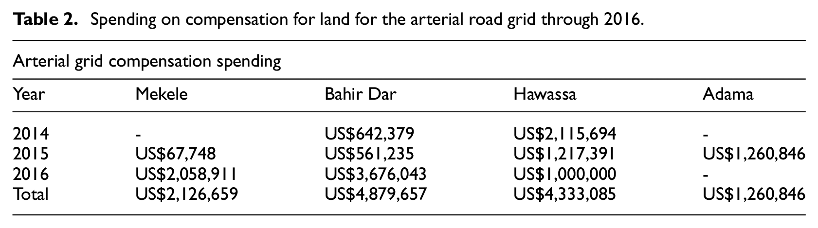
In lightly settled agricultural areas the land for the roads was not immediately taken for use, but the current leaseholders were paid compensation and informed that the land would eventually be used as the right-of-way for a road, and that any structures built on it in the future would not receive additional compensation. The other common scenario involved informally settled urban areas with dense populations. In these areas, residents were supported in reorganising their plot boundaries to accommodate the road network, in exchange for formal leases. The total spending on compensation for landowners is summarised in Table 2.
Spending on compensation for land for the arterial road grid through 2016.
Construction of the roads was undertaken by the city governments themselves, sometimes with engineering assistance from the local university. There is no clear data on how much was spent on construction costs, as the figures for the arterial grid were often merged with other road spending. 6
As of mid-2017, 390.9 km of roads have been constructed in Bahir Dar, 163.3 km in Hawassa, 9 km in Mekele and 7.7 km in Adama.
A total of 570.9 km of roads (mainly dirt, but in some cases gravel and asphalt) was completed under the UXI in three years. These roads were partly paid for using city resources, including tax revenue and conditional transfers, with additional funds coming from the regional bureaus.
By any standard, this is a remarkable achievement in a very short time, and officials working with the programme are enthusiastic about its potential, particularly if funds for implementation are increased.
Much new urban land has been provided in the expansion areas alongside these new roads, but the rate of increase in urban land has not kept pace with demand and cities have struggled to achieve their planned targets (Table 3). City officials report that this is due to a lack of funds for acquiring and servicing the new land.
Land leased at auction and revenues from land leasing (planned target and actual performance).
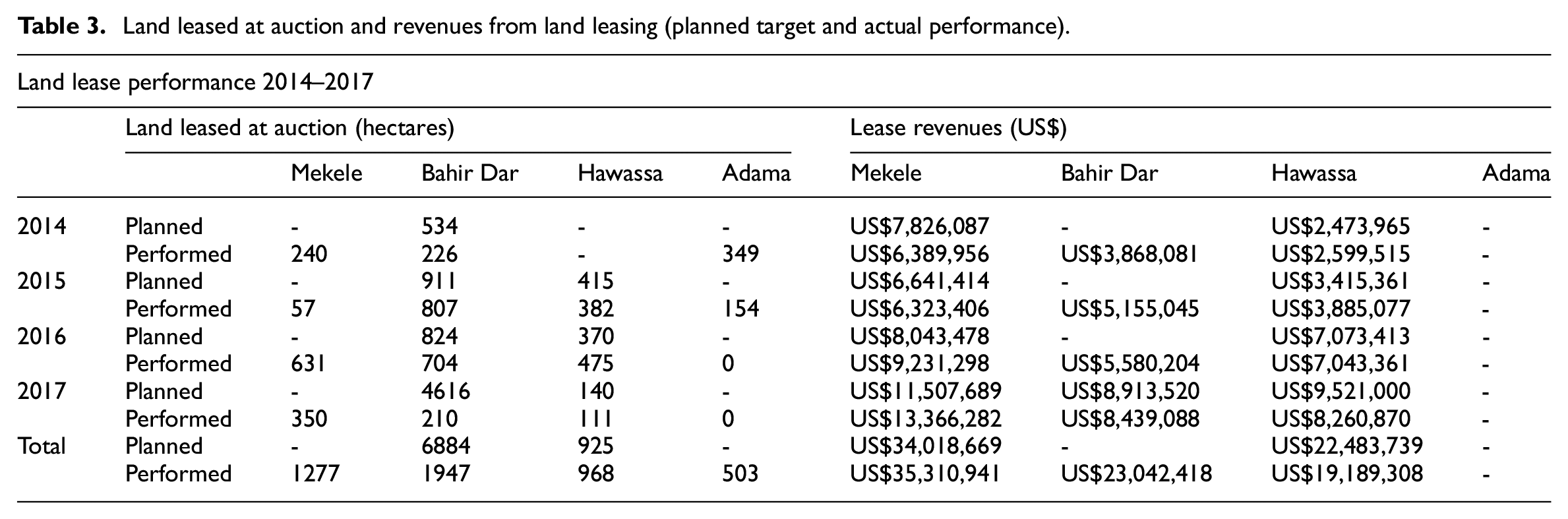
The leasing of serviced urban land is a major potential source of revenue for these cities. Table 3 shows that the cities have sold leases worth over US$77 million in the past three years in their expansion areas alone. However, Ethiopian law requires that land be provided with basic minimum services before it can be leased for urban use, and, aside from a small down payment, revenues are collected over the life of the lease – in some cases as long as fifty years. This means that compensation must be paid for the land, the land must be subdivided, roads must be built, water piped and power lines strung, before any significant revenue is generated. The resulting cash flow problems at the municipal level are likely the main reason why the land leasing system has failed to provide for the growth of Ethiopian cities (Kaganova, 2014; World Bank, 2016). The law attempts to address this issue by requiring municipalities to reinvest lease revenues in land development. The government could accelerate the delivery of serviced urban land by providing additional startup funds for land development and by strictly enforcing the reinvestment provision.
There is a relationship between the retention of lease revenues and the capacitation of the urban bureaus. In Hawassa and Mekele, lease revenues were used to create teams of surveyors, bring on mapping experts and compensation experts, employ sociologists and outreach workers to negotiate with landowners, and construct new roads. With this added capacity, Hawassa negotiated with informal settlers to exchange land for formal leases, essentially turning a liability (extensive informality) into an asset (land for roads). Many of the arterial roads that have been constructed have, in fact, been ‘opened up’ in congested informal settlements. Because of this ability to solve several policy problems at once, the regional government and the city have both dedicated additional capital funds to the programme, above and beyond its official allocation. Local officials report that the city is on track to complete compensation of the arterial grid by 2019/2020.
In Bahir Dar and in Adama a portion of the lease revenues went to the regional government. The urban bureau in Bahir Dar was able to leverage federal funds for a cooperative housing project in the expansion area, and in 2014/2015 they leased 4080 new serviced plots in the macroblocks created by the first 15.5 km of arterial roads. In Adama, plans for a new ring road were integrated into the project, bringing additional funds. In Hawassa and Mekele, planned federal investments in industrial parks were used for the same purpose.
The provision of public open space
Progress has also been made in securing and protecting environmentally sensitive open spaces. Mekele, Bahir Dar and Hawassa are developing small parks at the neighbourhood level and are reserving land around lakes and rivers or on steep slopes, and this has been indicated on their plans. Mekele has reserved 50.1 hectares, Bahir Dar has reserved 628.9 hectares, Hawassa has reserved 4496 hectares and Adama did not provide data. In total, the cities have paid approximately US$1.9 million in compensation. NYU is working with city officials to formulate plans to prevent informal settlement in these areas.
In 2016, the mayor of Hawassa approved a plan for the creation of a 500 ha park around Lake Hawassa, to be called Adare Park. This will create a 100 m buffer of land around the lake in the areas controlled by the city. It will also serve as a passive environmental buffer that will help protect the lake and its fisheries from runoff. The Hawassa city government and a team of Stern Signature Students at NYU collaborated on the plan, 7 and the city recently launched a public open space partnership to raise private funds for amenities within the park.
Adama and Oromia Region
The lack of available data for Adama can be partially explained by its non-participation in the programme, and this non-participation can be traced to the violence in Oromia Region in mid-2016. It is widely believed that the violence in Oromia was the result of overzealous land seizures by local governments, often on behalf of foreign corporations. A proposed plan to expand the urban boundary of Addis Ababa into Oromia region met with further violent resistance, as farmers claimed that compensation payments were unfair and that they were being forced to move. The reaction of the Adama city administration disempowered the urban bureau in Adama, and the regional leadership is now sceptical about any plans for urban growth, regardless of content.
This is truly a shame, as it is the opinion of the authors that our planning programme offers an alternative to the sort of planning actions that sparked the violence. Under this programme, farmers and other landholders can remain in place, while receiving cash compensation and a seat at the table as their city grows – a recipe for mutual prosperity, we hope.
These reversals are not uncommon in international development work. For instance, a similar programme in Ecuador was derailed by the sudden decision of the President to cancel all World Bank projects irrespective of content. In this case, the national government supports additional engagement with Adama and we are hopeful that the effort there is merely on hiatus. One lesson emerges – effective institutionalisation means considering all of the ongoing planning practices in a given city, rather than ignoring parallel processes that might undermine our specific effort.
Conclusion
Of the four cities that began the programme, one is no longer participating and three have expanded their arterial road networks and increased their supply of serviced urban land. Actual plan implementation started in mid-2014 with the receipt of the first funding allocations, and it is now possible to see results on the ground in Ethiopian cities (Figure 4). In total, the four cities had constructed at least 570.9 km of arterial roads by mid-2017, opening up large amounts of land for urban expansion and creating a framework that will integrate newly developed areas and facilitate the creation of a metropolitan labour market. Importantly, the time horizon for planning has been lengthened and the process has been linked to accurate population and spatial extent estimates that can be periodically revised moving forward. Local officials have been capacitated to create and implement the plans.

New housing being built in the expansion zone of Bahir Dar, Ethiopia, in December 2017.
Local officials managed the design process in its entirety, along with the surveying, payment of compensation, management of budgets and eventual road construction. In some cases, this necessitated the hiring of additional staff and the purchase of equipment, but this was on the scale of one road grader, or three surveyors, or a laptop.
In a recent round of interviews conducted by NYU, city officials stated that the urban expansion programme has increased the supply of formal land and reduced informality.
Informality continues to be the main vehicle for land delivery in Ethiopia. In the long term, the orderly opening of vast new territories on the urban fringe may merge with land reform and slowing population growth rates to allow city governments to ‘get out in front’ of informality and increase the share of formal development. There is now a much better chance that even informal development is going to occur within a framework of arterial roads.
Resource constraints have not impeded the development of the arterial road network, but they have impeded the delivery of serviced urban land – cities are performing below plan targets. MUDH has directed the cities to scale up their efforts on urban expansion; their success in fulfilling this directive will depend on more funds being made available.
Aside from funding constraints, the biggest weakness in the implementation has been the lack of institutionalisation of the programme. High turnover in the city administrations meant that city leaders were often confused about the objectives of the work, and were occasionally reluctant to continue the work of their predecessors. Officials who have participated in the programme are enthusiastic about it and have attempted to convince others of its worth, but there have been difficulties in transmitting core theoretical concepts. These officials have requested additional support from NYU and from the federal government to ensure continuity and to address misunderstandings about the nature of the programme. In total, three consultants and one researcher undertook 10 visits over a three-year period and more visits would be useful.
Including capacity improvements, the total cost of securing the land for the grid is estimated to be about US$13.3 million per city. This investment is more or less within the means of cities in Ethiopia when they are able to spread the cost over several years and share costs with the regional government. This finding is hopeful, as it indicates that cities may be able to pursue this methodology without seeking donor funding.
The GoE is also generally satisfied with the results, and in June 2014 the Ethiopia UXI was expanded to include 14 additional cities – the Phase II cities. These cities received support from NYU through a grant provided by Cities Alliance. Encouragingly, skill sharing from the Phase I cities has made the Phase II cities less dependent on NYU support. There are also spillovers from the course at the Ethiopian Civil Service University that was established in 2013; this course has now educated hundreds of civil servants in the strategy of planning for urban expansion and they are making their way into government.
Empowerment is a key result of this work – planners who had previously struggled to chart the long-term trajectory of their cities now have the tools (and some of the resources) to organise the urban periphery. This is largely due to the simplified and decentralised nature of the plan – most decisions can and should be taken at the local level, without resorting to outside experts, international funders or expensive data collection exercises.
The UXI has reminded planners that it is possible to plan very large areas without seizing large amounts of land (no more than 8% of the total expansion zone), and that the taking can be done without disrupting the current inhabitants – an important piece of knowledge in the current political climate of Ethiopia.
The purpose of this article is not to assess the overall success or failure of the project – we are less than one-sixth of the way through the plan period. Rather, it is to present the story of the work so far, and to make an inference about the long-term feasibility of the effort based on current trends – a conclusion that is, in the opinion of the authors, generally optimistic.
Footnotes
Acknowledgements
The authors would like to acknowledge the assistance of Minister Mekuria Haile, Israel Tesfaye, Jason Parent, Daniel Civco, Zinet Ibrahim and the India Urban Expansion Observatory.
Declaration of conflicting interests
The author(s) declared no potential conflicts of interest with respect to the research, authorship, and/or publication of this article.
Funding
The author(s) disclosed receipt of the following financial support for the research, authorship, and/or publication of this article: This research was funded in part by Cities Alliance.