



Abstract
This article presents the precolonial map of religious buildings in old Algiers (Casbah) that is based on an unedited manuscript that goes back to 1870. It helps to reconstitute the original urban fabric, locate the disappeared buildings, and identify the impacts of the demotion actions on the town. Among the 167 buildings that existed at the arrival of the French army, only forty-seven buildings remained at the time of the author. The approach combines the literature sources with old maps and the detailed sketches that were undertaken by the Genie Militaire. The overlapping of the historical data on the present satellite images was made through georeferencing and the use of geographic information system, ARC-GIS 10.6. Beyond the understanding of the present urban geometric complexity of Casbah, this work helps in colonial historiography and raises historical consciousness in architecture and planning.
Introduction
The importance of this work comes from two sides. It presents an unedited part of a manuscript that was kept in the archives of the national library of Algiers (Bibliothèque Nationale de l’Algérie [BNA]). It also permits to reconstruct the map of Casbah urban fabric before the French colonization. It focuses on the thematic map of the religious buildings that have mostly disappeared since the first decades of the French conquest. The work of Albert Devoulx (1826-1876) is not only a historical description but also a field survey on the city’s architecture and geomorphology that lasted decades, as demolitions operations spread over the first forty years of occupation.
The nature of the drawings gives us the details of the situation before and after demolition successive actions. Such a piece of information permits to reconstitute the urban fabric, the map of the Real Estate, and the immediate surroundings of the mosques.
The utility of this works may also extend to the domain of microstoria that relates urban history to both social and cultural histories with regard to the local community at the early moments of the French capture. 1 The distribution pattern of the religious buildings reflects the social map of Muslim rites (mainly Hanafi and Maliki) and the location of the newly arrived Christian and Jews communities in Casbah. The retrieved map may also shed light on the religious beliefs. The significant presence of the tombs of pious people who were believed to be the safeguard spirits and a source of divine Mercy denotes the place of the religious knowledge at that period. In the civic realm, religious buildings were part of an urban system that had multifaceted roles. It covered education, health care, and teaching services and provided shelter for homeless and poor people and refugees.
The Manuscript
The manuscript on old buildings of Casbah was initially published in a series of articles in Revue Africaine journal (1856-1962) under the title Edifices Religieux de l’Ancien Alger. Articles were then compiled in a book that was made public in the French National Library (BNF) through its website Gallica in 2007. 2 This compilation of 270 pages that is limited to the text seems to be shorter than that of the BNA in Algiers. The latter, besides its handy text, contains many illustrations and drawing plans of the buildings that were not published elsewhere. 3 As Devoulx grew up and died in Algiers, this document seems to be an annex of his major work on the topography of Algiers that won the Prize of the Algerian (French) Academy, established on March 31, 1870. 4
Regarding the content, the manuscript describes all religious buildings in Casbah at the early age of colonization. The buildings mainly consist of mosques, either great ones Jami or daily prayers places, tombs, public latrines, and Quranic schools, zawias. 5 According to the author, Casbah during the first year of colonization comprised thirteen khotbah mosques Jami, 109 mosques, thirty-two tombs, and twelve religious schools. That makes, according to Devoulx counting, a total of 176 buildings. In 1862, that is, during the time of the author, or precisely, when he started writing down the articles’ series, the total number was brought down to forty-seven buildings as there remained only nine main mosques Jami, nineteen small mosques, fifteen tombs, and five schools, most of which were out of order. In a recent academic work, the number of 176 buildings was however contested as the official report of Mangay, the Captain of the Genie Militaire, counted only 103 mosques and nineteen tombs in 1836. 6 The difference, according to the author, is due to the nature of some buildings that were so insignificant, in terms of size and architecture, that they were not recognized by French officials.
The full manuscript comprises two complementary and fused parts. The first one that consists of a detailed description of the buildings seems to have relied on the available local documents, mainly endowments waqfs acts, and narrations from autochthone managers, known as Oukils, and the local community under the continuous pressure and threats of the military administration. 7 According to Devoulx, a thorough document, waqfiah, that listed all religious buildings as well as their endowed assets, was lost in 1843, when the French authorities confiscated all the documents of the great mosque. 8
The second part of the manuscript regards the professional drawings and building plans that would have been undertaken by the military engineers and surveyors, Genie Militaire. Drawings that are in total seventy-six contain detailed footprints of the preexisting buildings and the lines of the new streets Right-of-Way. A colorful pattern clearly distinguishes the earlier shape of the buildings and their state afterward. As a professional work, they seem to have been collected by Devoulx, thanks to his prestigious post as an archives conservator and an agent of the Domain, and his knowledge in Arabic. 9
The Author
Albert Devoulx (1826-1876) is a French administrator who had migrated to Algiers with his father Alphonse at an early age and spent his life in it. His father who left France to North Africa in 1849 first was known as a Mediterranean negotiator who had seemingly accompanied the early military convoys to occupy Algiers, thanks to his Arabic background and knowledge in North African cultures. He settled in the town that became the new capital of French new territory and worked as a receiver of the Domain and Public Revenues since the early days of colonization. He gradually became closer to personalities of the leadership circle, a fact that paved the way to Albert Devoulx.
As an academician, Devoulx joined the Algerian (French) Historical Society that was established in 1856 and published its periodic issues, Revue Africaine, until 1962, the year of Algerian independence. The scope of the journal that embraced archeology, anthropology, and history provided a scientific domain in which Devoulx extensively published his other works, around twenty-nine works, on the precolonial and colonial Algiers urban history. 10
The Author’s Surveying Method
As a major mission of the Domain was to detect and survey all properties that belonged to the former public authority, the task of Devoulx seems to have extended much beyond his office and his work on documentation. On-site investigations on cases before and after demolitions would have often be coupled with a persistent checking of the reports and financial balances provided by the local managers, Oukils, who were his main interlocutors and were in continuous conflict with his institution. 11
As a way of structuring his work, Devoulx subdivided the Intramuros territory into an irregular grid pattern of three columns and four rows. The twelve zones were then presented following an anticlockwise pattern of an observer who stands facing the town from the port and turns his back to the sea. He starts from the lower Casbah, known as W’ta’, and walks gradually toward the Upper Casbah, called Jebel, that is, the mountainous part. Remote buildings located outside the town walls were left at the end.
Data and Method
The present work relies on a digital copy of a written manuscript that is acquired from the archives of the BNA. The document consists of a written text that alternates with plans, sketches, and photos of the religious buildings of Casbah. On verifying the content of the manuscript, it was found that it entirely matches with that of the articles published in the Revue Africaine during the period 1863-1870.
Besides the literal description of locations that are embodied in the text, early maps of the streets at the time of description and the names of the streets have been collected from other archival sources. The early streets’ names, although available, have different versions, following the successive periods and town’s evolution. The early names that are not systematically listed but extracted from legal archives during the Ottoman period go back to the precolonial period, 1516-1830. After the French conquest, a new system of street naming and numbering was introduced. 12 Even within this early period, names have changed after the breaches actions that took place during the period 1831-1860. Widened streets have been renamed, whereas smaller ones that were located within the Right-of-Way have been swept away. Since 1962, that is, the independence, all streets have been rebaptized with national names that are being used nowadays concomitantly with the old ones. Previous academic works that established the streets list and mapped are those of Adrien Berbrugger in 1846 13 and Henri Klein in 1913. 14 Recent ones investigated the origins of the colonial naming system. 15
Maps of precolonial Algiers used in locating the religious buildings are mainly that of Captain Morin, dated in 1831, and Berbrugger’s map established in 1846. The first one gives the location of the streets before the widening works took place, whereas the second one gives thorough information on blocs and streets. Its large legend, besides being encumbered with the streets names recorded in an alphabetic order, lists most public buildings along them. 16
The old maps are first overlaid on top of each other and then on the present satellite images, through Geographic Information System (GIS) georeferencing and rubber sheeting. 17 A vector file of Casbah at present times, drawn for a recent preservation project, PPSMVSS, 18 has been acquired from Algiers local authorities. The three components were combined in ArcGIS 10.6 software and adjusted to WGS84, the World Geodetic coordinate System, 1984.
Another source that helps verify Devoulx work, and that has been used in this work, regards the Ottoman archives. The source comprises around twenty thousand property and endowments deeds, 520 registers of Beylik, Ottoman public domain, and Beyt El Mal, public treasury that are available in the National Archives Centre, CANA, Algiers. 19 Mosques and religious buildings were regularly stated in legal texts as landmarks that help locate properties and delimitate them. 20
The Analysis of the Manuscript
The present analysis consists of locating the 176 religious buildings that are described by Devoulx on the ground. Thematic mapping is done through a GIS (ARCGIS 10.6.1) at two levels. Edifice features such as their names, their nature, their date of construction, and/or demolition are represented as geolocated points-events to which tabular attributes are attached. They are approached at the town scale. At the bloc level, plans and major cases of demolitions that have been illustrated in Devoulx manuscript are highlighted in the second half of the study.
Mapping Outputs at the Town Scale
The nature of the religious buildings
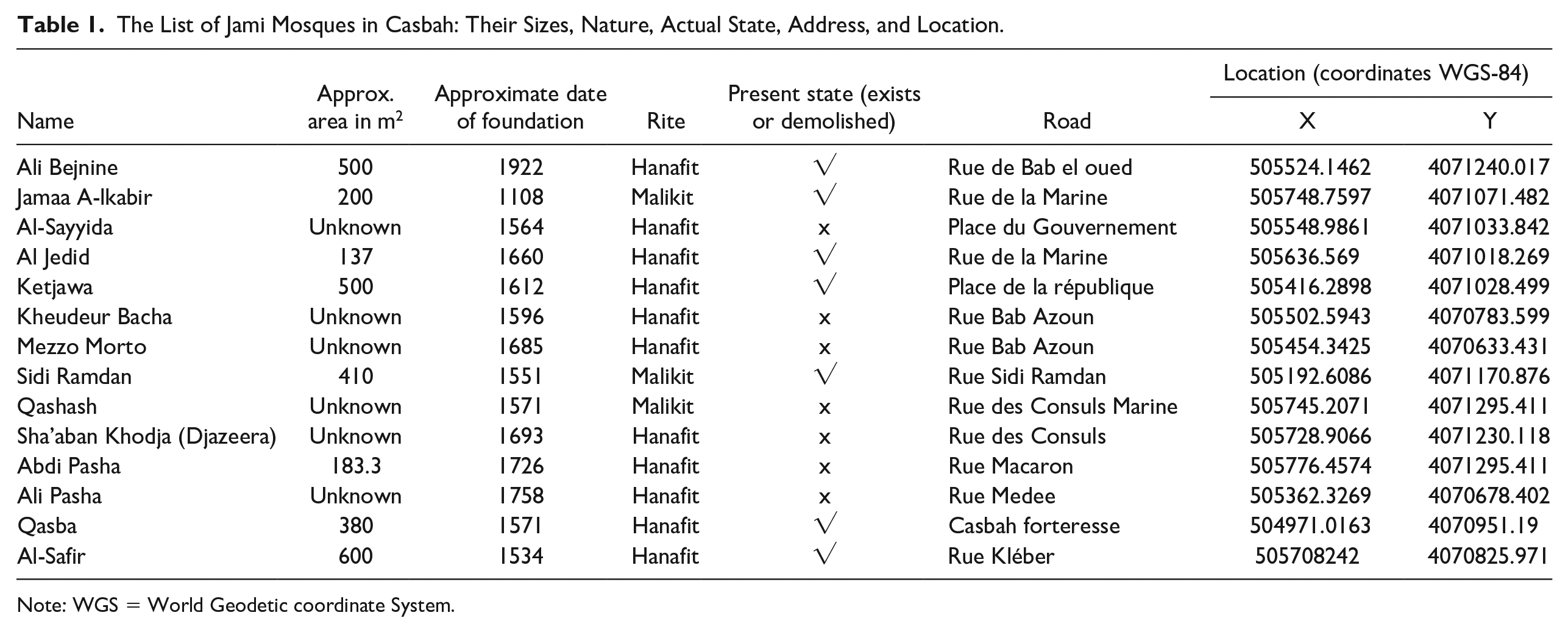
Jami’ mosques, also known as khotbah mosques, in which Friday prayer takes place, are the most important buildings in the religious hierarchy. Besides their large sizes that reflect their capacity and service radius, they also represent the summit of the religious authority in which Muftis (Islam’s foremost legal authority) and religious personage reside. That is the case of Jami El-Kebir and Jami El-J’did mosques that represent the two dominant rites, Maliki and Hanafi. As gathering spaces, they are also a source of public information, regarding the announcement of royal orders, events, news, and social exchanges (Table 1).
The List of Jami Mosques in Casbah: Their Sizes, Nature, Actual State, Address, and Location.
Note: WGS = World Geodetic coordinate System.
According to Devoulx, the town comprised thirteen mosques. On investigating on this number, Tal Shuval counted fourteen, most of which are of Hanafi rite. Although most of their foundation dates go back to the early Ottoman period, 1516-1581, an important number underwent renovation and renewal works that altered their original states. 21
As landmarks in the town, their buildings differ significantly from their surroundings by their distinct architecture, robustness, and size. A brief look at their areas shows that the Jami mosques have an average size that ranges between five hundred and two thousand square meters. Most travelers’ descriptions of the town and drawings are thus marked by these outstanding features. Minarets and domes are the most significant components of their architecture that cross the town skyline.
The importance of Jami mosques may also be recognized from their endowments. As for maintenance, repair and daily management of mosques are self-financed and depend on their endowments’ outcomes. Founders have the tradition of creating many charitable assets once mosques are finished. Each mosque has its waqfiah document that specifies the list of assets and the distribution mode of their revenues on daily expenses and periodic repairs such as lighting, carpeting, cleaning, staff wages, and annual walls cladding. For instance, Jami El-Kebir endowments are reported to be 125 houses, three bakeries, thirty-nine farms, and 107 other parts of assets. 22 Jami J’did, that is second, had in total sixty-seven shops and thirty parts of shops. Whereas a moderate mosque like Sidi Rahbi, which was located near Bab El Oued, opposite to Ali-Bitchine Jami’, had only seventeen endowments that comprise five houses, ten shops, a farm, and a field. Incomes from these endowments were estimated in 1834 to be 586 French Francs, days before this mosque turned into a store for the pharmacy of French soldiers. 23
Daily mosques in which the five prayers are performed rank second in hierarchy. However, they outnumber all other facilities, as they are in total of 109 buildings. Due to the coexistence of many ethnical communities, there are also two major categories of mosques, the Maliki ones that belong to the local communities formed of Arabs and Berbers and the Hanafi mosques that belong to the Turkish community. This latter is itself formed of janissaries, governors, and kulughlis—descendants of Turkish fathers and Algerian mothers.
Zawias that are mostly buildings that offer basic education and Quranic memorization to children at an early age come at third position. 24 However, they are often attached to, if not merged with, mosques. This is the case of Ketjawa, El Djedid, Al Qashash, and Sidi M’hamed Sherif zawaias that form with their mosques one entity (Figure 1). In some cases, zawias belong to a certain ethnic group and exclude the large public. Among these, we can state Al-Andalusiyyn medersa that was exclusively erected for the Moorish refugees and the al-Shurafa that was restricted to people who are believed to be the prophet’s offspring.
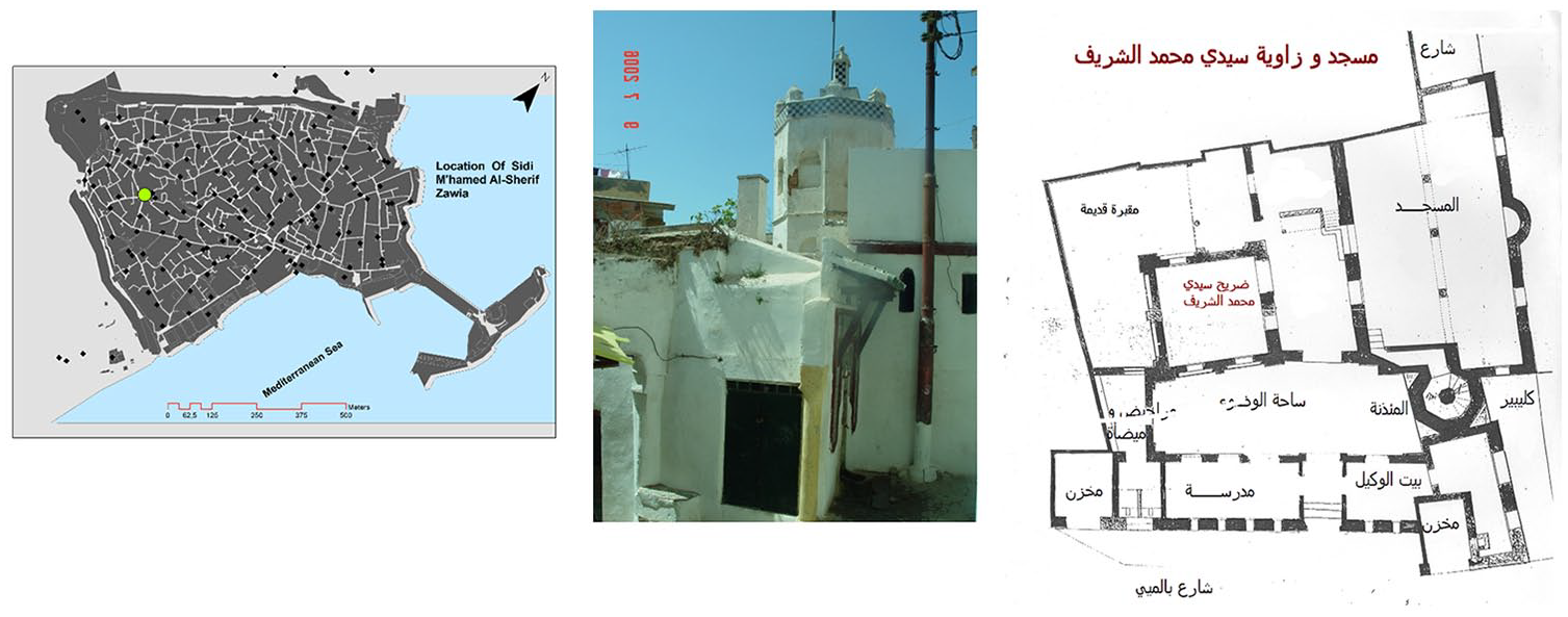
Zawyia of Sidi M’hamed Sherif comprising a tomb, a mosque, and a madrassa.
Among the thirty-seven zawyias counted by Devoulx, only thirty-two could be mapped. Unidentified ones are either located extramuros or have their locations not mentioned in the manuscript. Regarding their classification, zawyias may depend on their location, that is, whether inside or outside the city walls, and their sizes. Those in Intramuros are mostly destined to teaching, whereas the ones located in Casbah outskirts may provide accommodation and food to internal students as well as travelers and passers-by.
Tombs are another distinct category of religious buildings. They are graves of pious persons who are reputed for their good deeds, supernatural virtues, and wide religious knowledge or are descendants of the prophet. Just after their death, they are honored and their graves are memorized with a vaulted room. Depending on their reputation and the number of their offspring, their tombs become sacred places for frequent visits of people seeking blessing and personal prayers. Too often tombs become an integral part of the town’s history and their names are subjects of mythology and superstitions. They are, for instance, believed to have an exceptional place of holiness and closeness to God and a spiritual power that extends beyond death and exercises protection on the town and its people, a fact that gave the name of mahrussa, that is, “the protected,” to Casbah. 25 That is the case of Sidi Ouali Dada who is believed to have miraculously defeated Charle-Quint in his massive expedition on Algiers in 1541. 26
On mapping the tombs, their locations may not be as accurate and exhaustive as the other buildings. In most of the cases, they are located within the zawias and/or mosques, as these latter are often named after them. Among the most known tombs in Casbah are Sidi-Abdurahman Thaalibi, at Bab El Oued gate, and Sidi Abdelkader Jilani, outside Bab Azoun gate.
Institutionalizing demolition actions
The first decade of colonization, from 1830 to 1840, was known as the military offensive period. The role of the militaria then in Algiers town affairs gradually shrunk in favor of civilians as soon as the other cities and territories surrendered. Increasing voices of politicians and civilians also called for the dismissal of the Casbah and its abandon to the Arabs. The increasing number of European settlers opened the perspectives to extramural extension and compelled the authorities to push back the borders of the town outward on both sides along the coast, first at Bab Azoun and then at Bab El Oued. The visit of Napoleon III to Algiers in 1863 was the marking moment that witnessed a lenient attitude toward the endogenous culture, the preservation of the médina, and the emergence of the coexistence policy between Arabs and Europeans in the same city.
In terms of legislation, demolitions were often founded on declaration for Public Utility that was softened by the compensation procedures and concessions. During the early period of towns’ capture, the predicted cut-through actions were undertaken more or less diligently so as to reduce expenses of expropriations and minimize hostile reactions of residents. 27 Alternatives paths that went through public land, mainly Beylik and Waqfs domains, have been preferred and private cases were reduced. 28
Urban regulation that accompanied demolitions matured over time and on the ground, following circumstances and challenges. It witnessed a gradual refinement and amendments that not only adjusted public actions in the new colony but preceded the early French legislations in the mother-country to which it referred. 29 In the absence of any civil opposition that would protect the civic and private rights of autochthons, 30 Algiers had become a field for urban experiments that would have nurtured the Grand Public Works of Paris conducted in 1852 by Haussmanian and that of other French cities such as Montpellier (1861) and Nantes (1866). 31
In terms of practice, the chronologic listing of the demolitions dates on the GIS software shows that demolitions had a decreasing trend. It was at its crest during the first decade, 1830-1840 as 56.96 percent of cases took place during this period. During the second decade, 1841-1850, the number of demolitions had significantly dropped to 30 percent (Table 2).
The Trend of Demolition Cases during the Early Time of Colonization 1830-1870.

On the ground, mapping the paths of the new arteries and streets, in the light of the alignment concept that responds to specific width standards and relies on the cartesian geometry and the straight line, illustrates the heavy consequences on the existing urban fabric (as shown in Figure 2). Around thirty-nine mosques are found partially or fully located on the blocs’ fronts and thus within the Right-of-Way of the predicted streets. Placed in the historical context, cut-through actions, and confiscations that together dropped the number of religious buildings from 176 to only forty-seven, would have then targeted the religious map of Casbah.
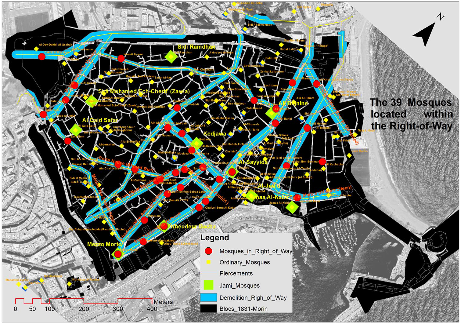
The demolished mosques located within the Right-of-Way of the new street network.
Distribution pattern
In response to the topography and the coastal location, the urban form of Casbah has two distinct areas. The lower Casbah, known as W’ta’, that is flat and the town center and the Upper Casbah, known as Jebel and Sened el-Jebel, that is mountainous and mostly residential. In this latter, houses are staggered on top of each other, offering a view on the sea to each house through the cascaded terraces. Accordingly, the geographic distribution of public buildings over the town is uneven as most facilities are concentrated in the town center, as shown in Figure 3.
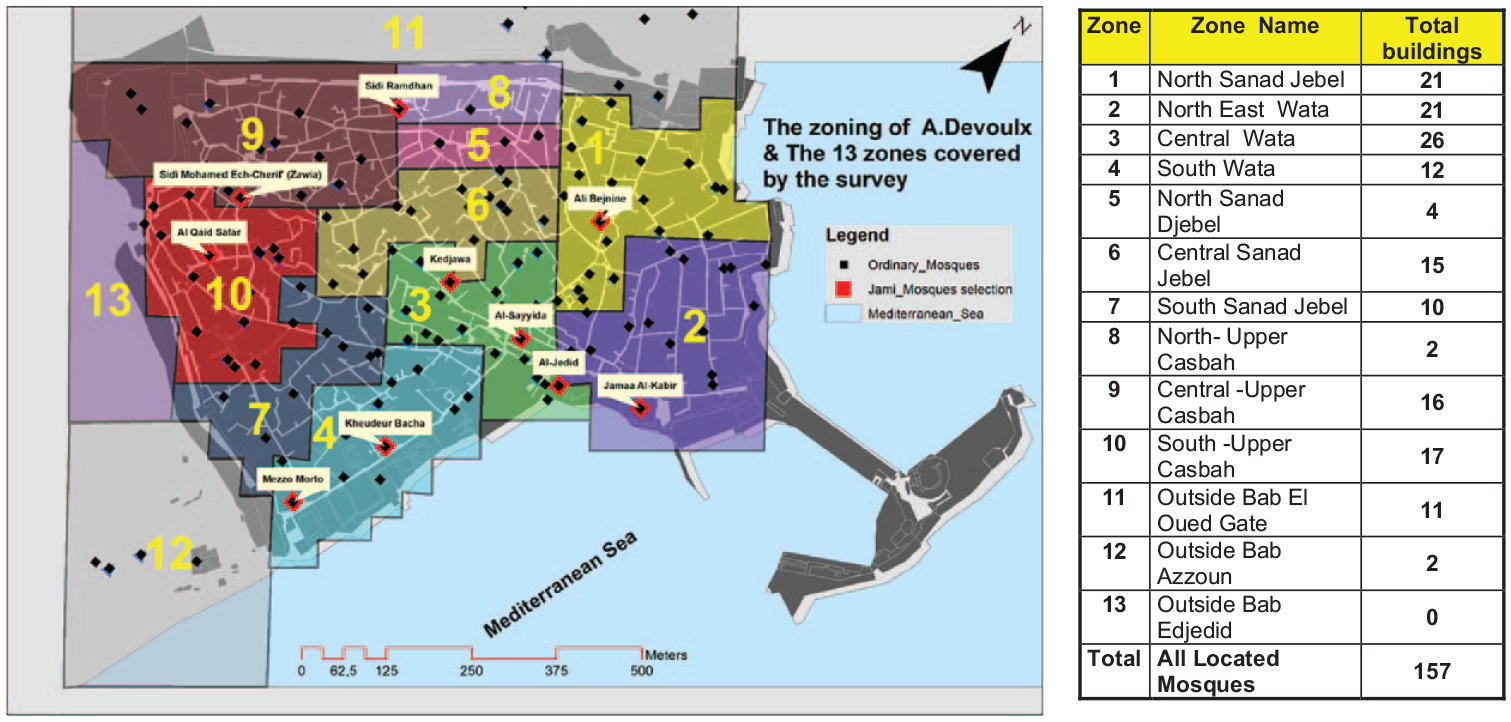
The distribution pattern of religious buildings over the town territory according to the Devoulx zoning.
On referring to Devoulx survey zoning, the first two zones that cover the lower Casbah are the densest ones and have together a quarter of the mapped buildings. Zones 1, 2, 3, and 4 that form together the lower Casbah counts eighty buildings, which is just over half of the religious buildings. Due to its flatness, closeness to the port, and density, it has witnessed the most demolition, reconversion, and confiscation actions. At present, old urban fabric in this area had completely been swept off.
The second half of religious buildings, all types confused, are however scattered over the upper Casbah that is the largest area in the town. Contrary to the main mosques, Jami, which are mostly located in the lower Casbah, a large number of daily mosques and teaching facilities are in this area.
Transformation actions
The description of Devoulx permits to classify the state of the religious buildings according to their postaction status. Compared with the important number of demolished buildings, that is, nearly 42 percent, there is 17 percent that were confiscated and converted. Due to the social shifts and displacements of residents, many religious buildings would have been abandoned and collapsed, which is explained through the high number of the unknown buildings’ state, that is, 27.38 percent. As most of the religious buildings were endowments, waqfs, or financially relying on other endowment incomes, such as shops, houses, stores, and workshops, they would also have collapsed for negligence (Table 3).
The State of Religious Buildings after the Transformation Actions Undertaken by the French Authorities between 1830 and 1870.

Cases of Demolitions
Ketchawa mosque
The foundation of this mosque goes back to the early arrival of Ottomans. Its name Keshi-awa, which stands for the sheep pasture, reflects the presence of the undeveloped land during the pre-Ottoman period in which the town was limited to the oldest core in the Upper Casbah. 32 Legal records note that the mosque was, at its origin, a religious school, zawiya, that carried the same name. According to Devoulx, Ketchawa mosque was stated in legal records that go back to 1612. However, it was rebuilt by the Pasha Hassan in 1794 in an identical plan with that of Al-Sayyida mosque. 33 Both mosques have a central space covered with a large dome that stands on a series of columns, a model that replicates the Istanbul mosques on a miniature scale. Its importance, among the four other main mosques, comes not only from its size but also from its strategic location that dominates the town center and its adjacency to Jenina, the former governors’ palace, which also homed the French governor of Algiers in early times of colonization.
Its conversion to a church was celebrated by the French army as a reconquest of a territory that had long been Roman and Christian before its invasion by Islam. 34 Antoine-Louis-Adolphe Dupuch was the first bishop who played a central role in propagating the impression that the French colonialism in Algeria was a historic revival of the spirit of Augustinian Christendom. 35
On describing the event, Arsène Berteuil notes that the conversion of the building was carried out at noon on December 18, 1831. 36 French troops stormed the mosque which had been barricaded by four thousand worshippers amassed inside to stop its conversion. The order to forcibly convert the mosque was given by the governor who acted in contravention to a clause in the instrument of Algiers’ surrender that guaranteed the Muslims’ rights to retain their places of worship. That was a violation that caused consternation even among some French officials. 37
In 1838, the government asked the Court of Rome for the erection of a bishopric for Algeria to replace the provisional regime. The pope Gregory XVI hastened to defer to the request for the erection and the circumscription of the bishopric of Algiers. 38 He then raised the city to the rank of a diocese, and the mosque-church was baptized to the Cathedral of Saint Philip. 39
Pierre-Auguste Guiauchain (1806-1875) was the first architect to work on the project. He presented plans for the reconstruction of its building. Many others after him, namely, Amable Ravoisié (1801-1870), Jean Saint Eugèe Fromageau (1822-1897), and Albert Ballu (1849-1939), contributed to giving the cathedral its actual shape. 40 As the successive retrofit drawings show, initial work on the building encapsulated the old mosque within a new shell, that engulfs an area five times that of the mosque. A new façade that reflects the Christian identity and raises it to its prestigious rank of the first cathedral in North Africa was then worked out as shown in Figure 4a to c.
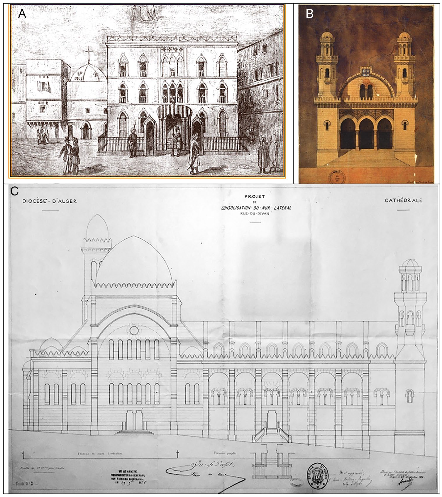
The different façades of the Ketchawa mosque transformed into Saint-Philippe Cathedral. [A-Ketchawa mosque (to left) before demolition, B-The cathedral façade by Albert Ballut, architect, 1856, C-Facade drawings by Jean-Eugène Fromageau, architect, 1856Q6]
Following the new role of the church as a gathering place for Europeans, and for aesthetical concerns that give the sufficient visual setback to the passers-by, an open space was created at its front entrance. A dominant façade with two symmetric towers holdings crosses and rendered in a byzantine style characterizes the front elevation of the converted religious building.

Various plans of the restoration of the Cathedral of Saint-Philippe, with the domed interior of the former mosque integrated into the scheme. The darkened block shows the original plan of the mosque before 1830. A-Successive alterations in 1830, unknown date, 1850, 1852, 1857, Jean-Eugène Fromageau, architect, B-Restoration works, drawings by Pierre-August Guiauchain, architect, 1843, C-Early plan of the cathedral, Albert Devoulx, 1870
Al-Sayyida mosque
It is ranked third among the Jami mosques, which was mentioned in the early writings of Haedo memories in 1581, 41 the famous enslaved Spanish author. Despite that its foundation is unknown, the earliest legal documents that referred to it go back to the 1560s. However, it seems not to have kept its original state as it has been rebuilt by Mohamed Pasha in 1784. 42 Despite its rank and scale, it had, according to Devoulx, a modest number of endowments. Assets were limited to three donations made by successive local governors, called Pacha: one from the Dey El-Hadj Mohammed bin Mahmoud (1677-1678), the other from the pasha Hassan (1681-1682), and, finally, the third from Mohammed Pasha, the restorer of the building. 43
Al-Sayyida is the first Jami mosque to have been demolished on April 1, 1831. In an early action of street widening, the traces of the main square that will be the Place Royale and then Place du Gouvernement include the entire footprint of the mosque. On arguing, this demolition that contradicts the French legal and moral commitments to local people, the administration deemed that, due to its proximity to the three other Jami mosques, it was not indispensable to the cult. On describing the malicious demolition process, witnesses reported that, in order not to excite the population, the genius secretly undermined the building for several nights. One morning, to the great astonishment of the Arabs, the mosque collapsed, which made them say that Muhammad abandoned them, that it was a punishment of God, for letting the city take over. 44
One of the planning arguments for the demarcation of the plaza is its centrality and proximity to the governor’s headquarter that was also the former Pasha’s residences, Jenina. The dimensions of the plaza were also made to respond to the military parades and introduce some regularity to the nongeometric surrounding urban fabric. Facades overlooking the square were established in a way to screen the back buildings and reflect a highly disciplined architecture. Overlapped on the existing town center, the early version of the plaza plan covers most of the central market, suq-al-Kebir, and extends over the two main mosques, Jami Jadid and Jami Al-kebir, that are miraculously still standing. 45 The plan that was established by the architect Francois Luvini was considered by Closel too ambitious and controversial. It was withdrawn and reworked to a lesser extent that is at its actual size. In a compromise with the adjacent buildings, the plaza was given its final pentagon shape that has an area of approximately one hectare and was since then named Place du Gouvernement (nowadays; Place des Martyres) 46 (Figure 6). 47
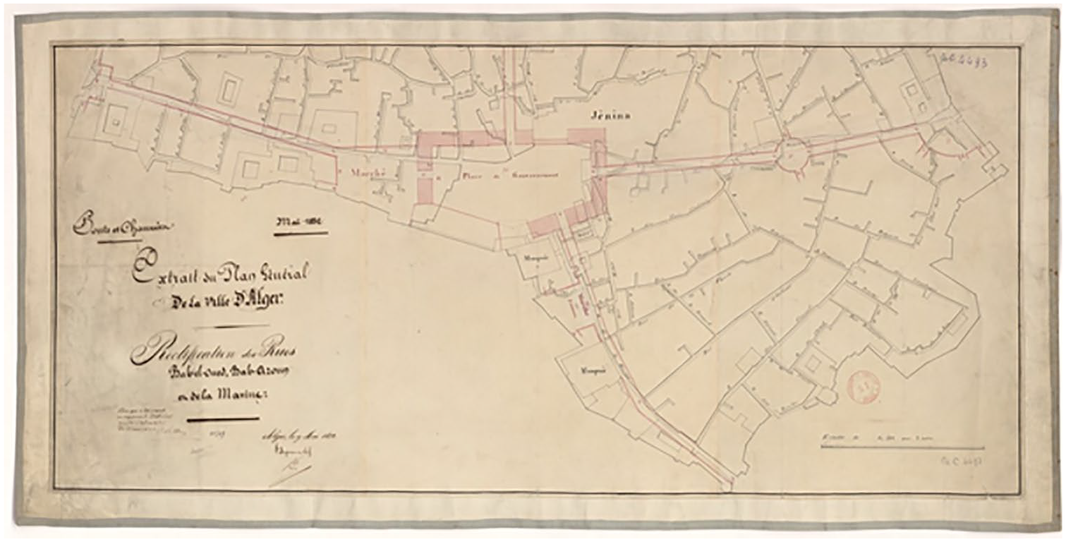
The overlapping of the three streets, Bab Azoun, Bab El Oued, and La Marine on the old urban fabric of Casbah and the demolition of Al-Sayyida mosque. Bibliothèque nationale de France, département Cartes et plans, GE C-4493.
Other Demolitions
Besides the two main mosques, many other ones have either been entirely or partially wiped off the map. Among the sixty-four drawings of mosques that have been reported by Devoulx in his unedited manuscript, this section will illustrate selected cases that were located in the Right-of-Way of the projected paths.
Mezzo-Morto Jami mosque
This Jami mosque is located within the Right-of-Way of the major artery that relates the two main gates, Bab Azoun and Bab El Oued. It is also located at the junction between this artery and Chartres’s new road. Its area was around 123.5 m2 and it was seemingly facing a large place called rahbat el-z’raa (grains market). It was founded in 1685 by the Pasha, Hadj Hussein, a converted Italian who ruled Algiers (1683-1689). It had an exceptional minaret and a large dome that covered its prayer hall. The mosque was a complex building that comprised a series of shops on the ground floor, a school, a fountain for potable water, a public bath, and latrines. Before its demolition, the mosque was confiscated and used as a military hospital until 1836, the date of its demolition (Figure 7). 48
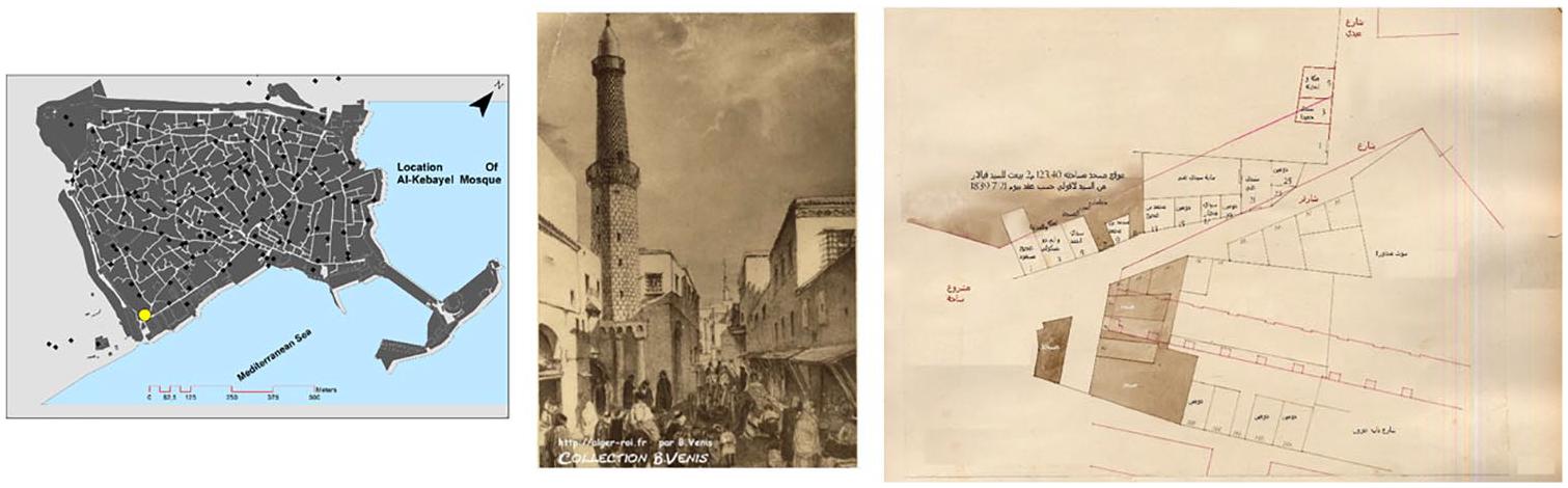
Layout plan of Mezzo Morto mosque demolished during the cutting through Bab Azoun street and its minaret.
Abdi Pasha mosque
Abdi Pasha’s mosque is named after the ruler who founded it in 1725. It was in the vicinity of the Janissary military casern and the two prisons along Macaron street, at the port area. The mosque was also close to the marine gate called al-Jazeera and had its back wall facing the sea. It was a Jami mosque with a total area of 183.30 m2. It followed the Ottoman style in its minaret that had an octagon shape. In 1748, a school, madrassa, was added to it by Pasha Muhamed Ben Bakir. Due to its strategic location at the bottom edge of the lower Casbah, it was razed and its ground was partially annexed to the Emperor street, whereas the other part was left free for promenade as a corniche. 49
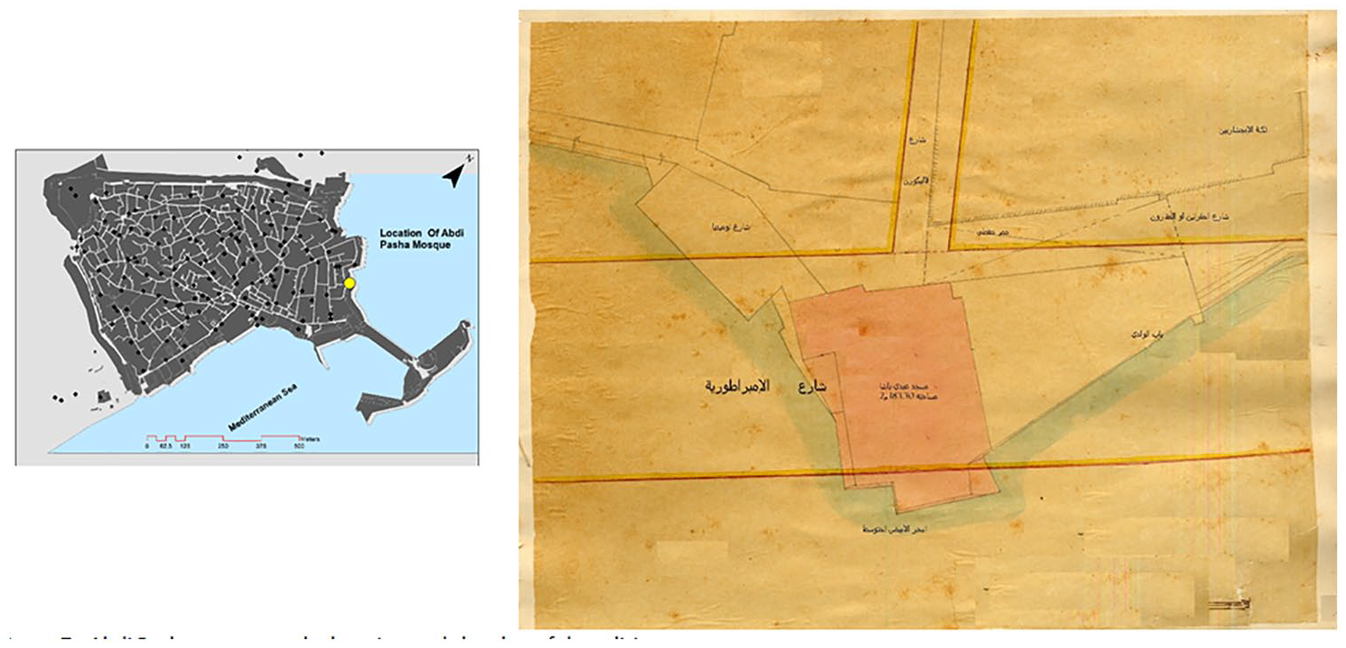
Layout plan of Abdi Pasha demolished during the breach of L’Empereur street.
Jami Lablat
It is another mosque that has been entirely demolished as it was found standing within the Right-of-Way of Napoleon and Nemours roads. It is a small mosque without minaret that goes back to the early Ottoman period that is around 1590.
Due to its sensitive location, it was among the first confiscated mosques that were used as a French military camp. In 1868, it was completely demolished for public utility. Its land was used to open the road linking Bab El Oued to Bab-El-Jihad 50 as shown in Figure 9.
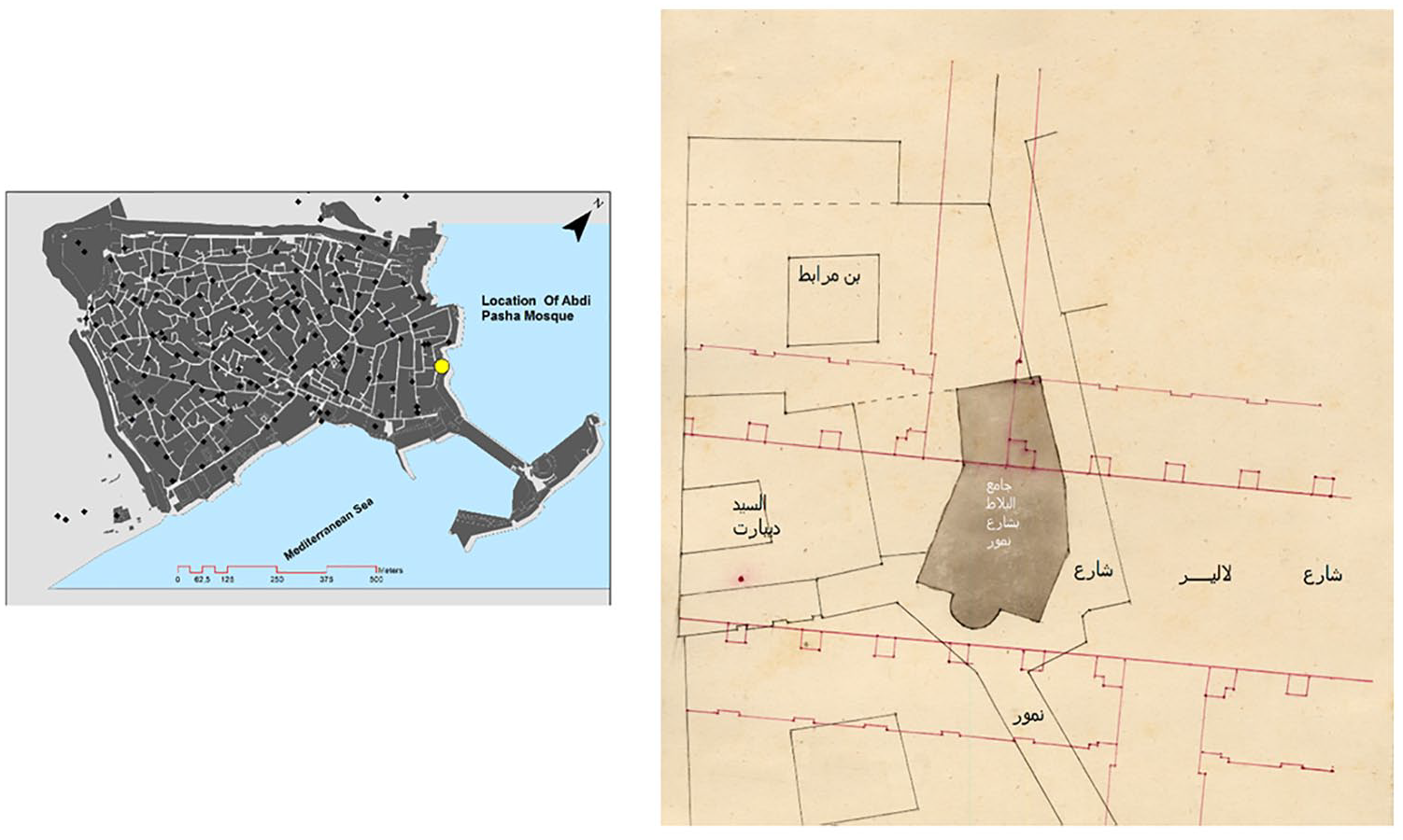
Layout plan of Al-Blat mosque demolished during the breach of La Lyre street.
Jami Laqbayel
This mosque was named after the Berber community that also had a covered vegetable-oil market called Funduq Al-Zeet, in the proximity. It locates at the junction between Bab Azoun major street and Boza secondary street. Its ground was found within the Right-of-Way of the major street and thus was swept off-map during the early breaches undertaken in 1836. The standing part of the building was retrieved and transformed into a house called Duchassaing 51 (Figure 10).
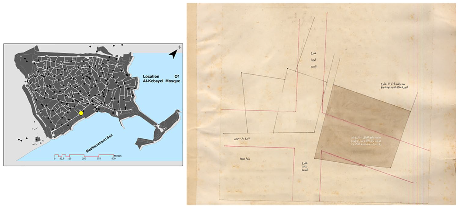
Layout plan of Al-K’bayel mosque demolished during the breach of Bab Azoun street.
Motivations and Pretexts of Demolitions
Often, it is difficult to determine the motivations of the French authorities for demolition, most of which were military. Various reasons and pretexts that range from the most tangible to intangible ones would be stated, depending on each case. A few of them would be deduced from the official declarations and facts, but others would remain discrete and thus may be deducted from their spatial and temporal circumstances.
In the early times of incursion, the major argument for expropriation and demolition was the need for accommodation space for the considerable forces of the French army. The expedition to Casbah, which was long considered an impenetrable fortress of corsairs, necessitated the mobilization of thirty-seven thousand people, four thousand horses, considerable logistics, and army food, a fact that raised a serious challenge of installation. 52 In counterpart, the old city provided only seven modest caserns and forts that would lodge two thousand soldiers. The General Debourmond, Chief of the expedition, was thus constrained since the first days to seize many houses that belonged to the deported Ottoman soldiers, as well as the religious buildings and assets that belong to the pious foundations, a fact that raised the Intramuros capacity of the town up to fifteen thousand persons. 53
On describing the events of the French settling in Algiers, Henri Klein listed in detail the thirty-nine religious monuments that were confiscated by the army, and then demolished or converted. 54
The second explicit argument to demolition is the need for the increase of accessibility and traffic fluidity, in response to the transportation means and the intensity of the traffic flow. Standards regarding road widths have been established accordingly. While the largest street in the old town would barely reach four meters in width, norms fixed the main roads to range between eight and twelve meters and should not be less than six meters. Accordingly, a Ministry Order on November 23, 1833, established the list of roads to which the Right-of-Way would apply. 55
Security concern is the reverse side of accessibility and traffic fluidity. As a dense town that became increasingly the last refuge to the indigenous community, its remaining upper part, since then called medina, became a symbol of social resistance and a cluster of rebellion. Religious buildings, because of their spiritual role in motivating residents, and gathering places would be thus military targets to military authorities. Piercing the irregular and dense fabric through itineraries that would affect the most encumbered paths with mosques would thus be a strategic goal that helps keep the indigenous community under control and discard rebellion spectrum. Such an interpretation is further argued with the undertaken decision for the demolition of all mosques located on the coast for security purposes. A miraculous exception regards the two now-existing main mosques, El-Kebir and El-Jedid, that were preserved, thanks to their proximity to the caserns and for being under fire from all sides. 56
The Public Health Movement that swept Europe since the early nineteenth century is another impetus that would stand behind demolition process in Casbah. Being institutionalized in France since 1820s, 57 it quickly infiltrated physical planning and building regulations. 58 Since the first time of colonization, the narrow streets and the compact fabric of the Casbah were considered an unhealthy milieu that requires ventilation and sun-lighting. On comparing the ratio of open spaces per inhabitants of Algiers with that of the European cities, the Municipal Advisor, Mr. Ranc, found that it had only four square meters, while Paris and London had thirty-four and one hundred square meters successively. He concluded that a sacrifice for salubrity and hygiene had to be made. 59
Embellishment was another paradigm of urban management that modeled Algiers and nurtured demolition actions. The concern for urban aesthetic was omnipresent since the early works of the architect Luvini in shaping the Place d’Armes. This tendency was crowned with the Plan d’Alignement, d’Extension et d’Embellissement d’Alger, and PAEE for Algiers a century later. 60 The landscape of Casbah that is shaped by the organic geometry and the curving contour lines of its hilly site was seen as lacking order and beauty. It thus required some touches of alignment and European landscape that refer to the Greco-Roman planning mode as well as the military disciplined mind.
Ideological and religious motivations, although discrete, would also not to be excluded from the list of motivations behind the massive demolitions of mosques and religious buildings. 61 On arguing on the chopping of the Ali-Bitchine mosque minaret that is located at the cross point between the Casbah road and Bab El Oued road, its height—that was fifteen meters—whose solidity considered doubtful was reduced to half in 1860. 62 Domes and minarets of mosques as symbols were the most marking landmarks of the city’s skyline that remind of its “oriental” character.
Impacts of Demolitions on the Town
The present section aims at tracking some of the eminent consequences of demolitions on Casbah. These range from the immediate ones that concern the town and the community at that time and the long-lasting effects that may be considered as part of postcolonialism studies that raised in the 1970s. 63
Spatial transformations at both urban and architectural levels are the most evident consequences of demolitions. Urban organization of Casbah that was based on the neighborhood concept, Hawma, was the most affected urban facet. 64 Besides their role as landmarks in the urban space that structured the image of the city and datums that were used to localize properties in courts’ documents, mosques had socially been the nodes of the community life around which many other services such as primary schools, public baths, gathering places, and small shops were grafted.
The destruction of the building frontages and the pushback of property lines on both sides of roads led to a radical reconversion of bloc façades and the masking of the traditional urban fabric behind the new elevations. A hybrid architecture that emerged as a result of the awkward plot shapes, the residues of the crushed constructions, and the hasting rebuilding actions led to a heterogenous coexistence of styles. 65
Effects of mosques’ demolitions extend to urban management. Municipal services basically relied on the autonomous and sustainable financial system of waqf endowments that itself depended on the religious institutions. As a transitional way to transfer the religious buildings and their institutions, and withdraw their social and financial tasks, a commission for the direction and monitoring of the Muslim religion in Algiers was created. It had the task of managing or rather “tinker” with official Islam for all of Algeria for more than thirty years, until the law of separation of churches and State was decreed in 1905. 66
Contemporary Map and the Remaining Buildings
Like most Muslim old cities, Casbah lost its prestigious status as well as its character as a medina and became a marginal quarter in the modern Algiers that accommodates the marginal classes of migrants and low-income people. Its urban fabric encompasses clusters of precarious houses that continue to deteriorate in spite of the many desperate preservation plans and its classification by the United Nations Educational, Scientific and Cultural Organization (UNESCO) as an International World Heritage since 1992. 67
Its mosques and religious buildings map that dropped from 176 to forty-seven buildings during the times of Devoulx (1830-1870) witnessed further shrinkage. The abolition of the waqf system that insured their maintenance, management, and staffing deprived them from their main financial sources. Their attribution to the Ministry of Waqfs and Religious Affairs that gives less care to historical mosques, as they fall under the Ministry of Culture prerogatives, further marginalized them.
Our fieldwork permitted to detect only twenty-five existing buildings. Despite some works of restoration, maintenance, and repair, most of these buildings are in an advanced stage of degradation. While the five mosques, namely, Jami Kabir, Jami J’did, Sidi Ramdan, Ali-Bitchine and Jami Safir, are still in service, there are only three standing zawias, namely, Mula Hassan, Shakhtun, and Sidi M’hamed Sherif, that are prevailing but are reconverted to other purposes. Tombs within and around Casbah have also disappeared with the exception of Sid-Abdul-Rahman Al-Thaalibi that is frequently visited by old people and tourists.
Conclusion
The aim of this work is to exploit an inedited manuscript of Albert Devoulx (1870), the French administrator in old Algiers, Casbah, during the early period of French colonization. The combination of the GIS approach with the archival maps and manuscript content helps rewriting urban history of the town, correcting the imprecision of old maps, and overcoming the overgeneralities of written historical sources.
The identification on the ground of the collapsed buildings and their overlapping on the street-widening actions show that breaches that were pretexted by the Right-of-Way and Public Utility would be an integral part of the colonial strategy that inherently targeted these buildings. The mosques and religious buildings that were the main gathering places and sources of spiritual motivation would have been regarded by the colonial authorities as a constant danger that should be eliminated or annihilated.
The demolition of mosques had other long-lasting effects. In the residential quarters, the mosques and zawias represented the kernels of the neighborhoods system, called hawmas, around which most other facilities were grafted. Accordingly, social life had been profoundly affected.
The endowment system, waqf, that played a sustainable financial system in the communal life, on which rely most facilities and services, had also been ruined. Mosques and zawias as religious institutions were the backbone of this system without which the whole management system would collapse.
Footnotes
Declaration of Conflicting Interests
The author(s) declared no potential conflicts of interest with respect to the research, authorship, and/or publication of this article.
Funding
The author(s) received no financial support for the research, authorship, and/or publication of this article.
