
Abstract
The objective of this study is to better understand how people gained resources to make Middle and Late Woodland pottery from Sipiwesk Lake in northcentral Manitoba. To meet this objective, we conducted petrographic analyses of sediments from Sipiwesk Lake, archaeological sherds from sites around the lake, material from outwashes, fired experimental tiles, and sherds from archaeological sites across the boreal forest ecozone and the prairie ecozone in the south-central and south-western regions of the province. Specimens from each sample were examined using optical petrography, X-ray diffraction, and scanning electron microscopy. Nine distinct fabrics (fired pastes) were identified by correlating the results of these analytical techniques. Each fabric can be considered a “paste recipe” that has local, regional, or pan-regional distributions. Local and regional distribution patterns redefine what “local” production means for mobile hunter-gather communities when the distances people travel for regular and routine seasonal activities are considered. This new model challenges exchange as an explanation for the spatial distribution of pottery. Expanding the range of exploitable distance thresholds for resource acquisition is alone enough to explain why the same pottery compositions would be found over vast areas incorporating one or more river systems. We further suggest that pan-regional recipes resulted from similar practices that served to add, remove, and/or alter the properties of nonplastics in clays. Such practices could potentially frustrate pottery provenience analysis, and we urge further research on the production of experimental pastes and the application of geochemical analyses to precontact Manitoba pottery.
Introduction
Acquiring the resources to make pottery—clay, water, temper, pigments, and fuel for firing—is the first stage in the manufacturing sequence. To understand how and where pottery was made, provenience studies attempt to link geological/geographical locations of raw clay, temper, and pigments relative to the locations of archaeologically recovered pottery. Various petrographic and chemical methods provide the means for inferring the geological source of clays, tempers, and pigments used in the manufacturing process (e.g., Pollard and Heron, 2008; Stoltman, 1989). These compositional data then provide a basis to infer cultural processes involved in the manufacture, distribution, and use of pottery. Often the initial objective of cultural interpretations is to determine whether pottery found at archaeological sites was made using locally gained materials, or whether the composition of pottery suggests that resources found outside the local area were used to manufacture the vessels. Assessing the use of “local” or “nonlocal” sources can be difficult because the geographic definition of “local” is ambiguous (Michelaki et al., 2015). Clay and temper sources can cover vast geographic areas, whereas extraction, or collection, locations across a source are geographically specific. Compositional studies cannot pinpoint the locations where raw materials used in pottery manufacture were extracted.
To improve the link between the composition of pottery and the possible geological/geographic origin of raw materials minimally requires a consideration of both geology and manufacturing processes. Tremendous improvements have been made in the instrumentation used to acquire petrographic and chemical data from pottery and analytical methods that compare the results of different techniques that together serve to evaluate the correspondence between the composition of clayey sediments and pottery (Grave et al., 2005; Larson et al., 2005; Tschegg et al., 2009; Willmes et al., 2016). The link between geological/geographic origins and cultural practices requires a consideration of how and why people collect resources in particular ways. Research on the cultural factors governing resource selection strategies and patterns has been more limited. The Ceramic Resource Area Model (CRAM), initially proposed by Arnold (1985, 1993), and since elaborated upon (Arnold, 2005, 2006), is the foundation for archaeological research on pottery resource selection.
Some criticisms have been levelled against the model because it does not account for the range of sociocultural mechanisms or factors that could be responsible for preferring particular clays and tempers over others, and the consequent effect this would have on the variation in pottery composition (cf. Kelly et al., 2011). Nevertheless, the model was never designed to cover all such mechanisms or account for all factors. Indeed, Arnold (2005, 2006) fully acknowledges that many factors influencing potter’s practices were not considered in the model. Gosselain and Livingstone Smith (2005: 34), for instance, summarize how procurement strategies in Africa may be affected by the local geology, individual perceptions of raw materials, settlement and land tenure patterns, competition among potters, local and regional social interactions, and techniques used in other steps of manufacturing. They clearly demonstrate how technical practices, learning strategies, other activities undertaken by potters, individual and group social identity, and symbolic reasons impact how ceramic resources are obtained. Rather than providing explanations that replace least-effort as a principle governing the acquisition of ceramic resources, these additional factors provide a nuanced, more complex, understanding of why potters would choose to use resources nearby or farther away. Considering such factors moves us away from “a static perception of potters’ behaviour towards a more dynamic and realistic one” (Gosselain and Livingstone Smith, 2005: 34).
Despite its deficiencies, for archaeologists, the most important implication of the CRAM is that it provides a means to link “resources areas” used by potters and the mineral and chemical composition of ceramics to infer areas of manufacture and patterns of interaction and exchange. Apart from helping us understand how distance to resources influences clay prospecting and selection, the CRAM has three interrelated problems that have seen no real solution. First, the model is based upon ethnographic data that assume energy costs to travel are cross-culturally similar. Mobility is based upon people carrying resources by foot, not using transport (pack animals, boats, or modern transportation). Second, ethnographic research indicates that resources for making pottery will be collected in tandem with other activities people undertake, such as collecting water and domestic fuel. In challenging the idea that the distance to resources and clay and temper quality are universally important considerations of potters, archaeologists have argued that the co-occurrence of resources on landscapes (e.g., water, clay, fuel, temper) tends to better explain why certain clays and temper are used for pottery manufacture (Kelly et al., 2011). This relationship was predicted for some time by ethnographic research in Africa (Gosselain, 1994, Gosselain and Livingstone Smith, 2005, cf. also Michelaki et al., 2015). Third, the model does not consider the further and more variable distances hunter-gathers may travel to obtain resources, including those for making pottery. In its current configuration, the CRAM is only based upon data from sedentary and semi-sedentary groups. This is a significant issue because few good ceramic manufacturing data are available for any historically recent mobile groups that could expand the applicability and predictive strength of the model. Without comparative data, most compositional analyses of hunter-gather ceramics in North America have thus focused on inferring regional exchange patterns (e.g., Beck et al., 2012; Eerkens et al., 2002; Thompson et al., 2008), thereby avoiding the question of “local” versus “nonlocal” production and resource selection strategies.
In this study, we identify pottery spanning a 1600-year period to compositional groups (fabrics or fired pastes) based upon mineralogical analysis. We then examine the spatial distribution of fabrics at three spatial scales: local (a single lake), regional (boreal forest ecosystem), and pan-regional (boreal forest and plains ecosystems). These patterns provide a basis for inferring the resource areas utilized by precontact hunter-gatherers in north-central Manitoba. Considering the impact that high mobility can have on both the manufacturing practices and the range of pottery deposited at hunter-gatherer sites led us to revisit the core concepts and data driving the CRAM, which were initially developed to examine raw material acquisition practices in sedentary and semi-sedentary societies (Arnold, 1985). In conclusion, we propose a working model of hunter-gather ceramic resource strategies for both grasslands and forest zones.
Previous pottery provenience studies in Manitoba
Two unpublished provenience studies from Manitoba offer insights for the design of the present study. One study focused on pottery from the Lovstrom Site (DjLx-1) in the plains of southwestern Manitoba (Brandzin, 1994) and another at the site of Tulabi Falls (EcKt-15) in the boreal forest region in south-eastern Manitoba (Burns, 1994) (Figure 1).
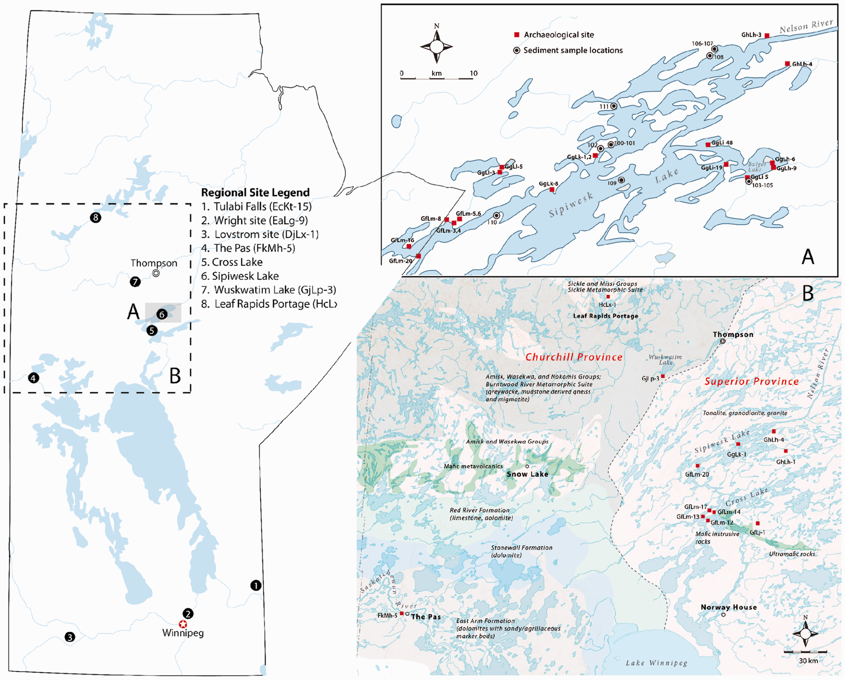
The study area. (a) Location of the archaeological sites and sediment sampling areas at Sipiwesk Lake. (b) Location of archaeological sites where other pottery was examined in the province against a generalized bedrock geology. Regionally, (The Lovstrom Site [DjLx-I] and Wright Site [EaLg-9] sit in the Churchill Province and Tulabi Falls [EcKt-15] in the Superior Province [see Table 2 for site data]).
Brandzin (1994) found that 14 sherds from Lovstrom fell into two broad groups: one with high and another with low quartz and plagioclase feldspar content, and all sherds contained various proportions of biotite and muscovite. The pottery compositions were also compared to six clay samples. Only quartz and biotite and illite and smectite clays were identified in raw clay samples using optical petrography and X-ray diffraction (XRD) analyses. One clay sample was collected from the site and the others were collected within a 16-km radius of the site. Brandzin concluded that youngest pottery, dated to some 450–550 BP, was made using clays outside this zone, while the older pottery from the site, dating from 700–1300 BP, was made using the “local” clays. The younger pottery may well have been made using local sandy clays, just not ones in close proximity to the Lovstrom site. The difference in composition may represent cultural and not just temporal differences, as the later pottery may have been produced by forager-horticulturalists who moved in to the region at the terminal Late Woodland period (Nicholson, 1988, 1990, 1991).
Burns’ (1994) more comprehensive petrographic analysis of pottery from the Tulabi Falls site reached a different conclusion. Tulabi Falls (EcKt-15) sits along the Bird River, a tributary of the Winnipeg River in the boreal forest of southeastern Manitoba (Figure 1). This study included 21 vessels dating across the Middle Woodland (200–1000 BP) and Late Woodland (700–1680 BP) periods. Combined XRD and optical petrography analyses distinguished some five main compositional groups based upon the occurrence of granitic temper, metamorphosed quartz, gypsum, chlorite, shell, grog, and phlogopite (Table 1). Burns concluded that the range of minerals is all available in the local geology. Consequently, potters produced a variety of paste recipes, some of which may be temporally sensitive or indicators of the technological preferences of different cultural groups.
The petrofabric groups identified at Tulabi Falls (Burns, 1994) based upon the results of optical petrography and X-ray diffraction analyses.
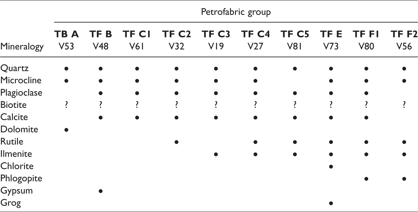
Although limited in scale and scope, these studies provide us with some important insights. First, including locally available clays in research designs is important. Brandzin’s sampling scheme involved collecting clays within 16 km of the site, far beyond the range predicted by the CRAM. The composition of clays provides a means of inferring a local profile of clay resources and how potters can manipulate them during manufacture to generate culturally appropriate pastes. Second, Burns’ study shows us how potters can generate a variety of “recipes” within a given geological/geographic setting, in part, influenced by preferences, and, in part, on the particular compositional profile of the clay deposits being utilized. Finally, both studies implicate technological change as an important factor in the variety of fabric types that can be identified at site. Fabrics can be temporally sensitive as well as spatial indicators of geologic source materials.
Percipient to these findings, we designed our study to focus on an area in the northcentral boreal forest. This area has seen considerable archaeological and geological attention, but the mineral composition of ceramics had not yet been studied.
Data and methods
The study area
Sipiwesk Lake has been both geographically and culturally significant to Indigenous peoples living in Manitoba for at least the past two millennia. The lake is located southeast of Thompson, Manitoba, and is part of the Nelson River drainage (Figure 1). The Nelson River connects Cross Lake with Sipiwesk Lake and drains northeast to empty into Hudson's Bay. The lake is therefore situated as a thoroughfare between Lake Winnipeg and the Nelson River, linking the north with the south, the boreal forest with the plains, and the boreal forest to the tundra further north. Its cultural significance is best exemplified by the identification of some 800 sites in the area. Over 106,000 pottery sherds have been recovered as surface finds or during test excavations at these locations, and 230 vessels have been identified (Petch, 2004; Syms and McKinley, 2004). Radiocarbon dates, ceramic styles, and direct dating of residues in pottery (Skalesky et al., 2011) indicate an occupation of the area by the Middle Woodland (200–1000 BP) phase, extending through the Late Woodland (700–1680 BP) and into the contact era.
The abundance of pottery recovered from the Sipiwesk Lake area informs us about both the importance of pottery containers in northern precontact lifeways and the availability of clays for potting in this area. Although the region is geologically diverse, only alluvial and glaciolacustrine deposits are the most easily accessible clays appropriate for making pottery. This limits the potential range and locations that potters could have acquired clay. We would argue that collecting clays and tempering material along shorelines were likely logistically preferred to traveling to remote inland sources. For instance, even 50 to 60 km northwest of Sipiwesk Lake, clay deposits are sparse. In a boreal forest landscape dominated by water, rock, deep deposits of sand and gravels, and a thin, acidic soil mantel, collecting clayey sediment from bogs, marshes, and pools would be better options for gaining potting clays in such a terrain. By contrast, Sipiwesk Lake, as with other lakes in the boreal forest ecozone, has an abundance of both locally available clay and grit tempering material accessible along shorelines where people lived and where many other routine activities occurred. It is more likely these resources were used in pottery making than remote sources further inland.
Geology
The geology of the Sipiwesk Lake area sits within the western margin of the Superior Province, and the lithology is dominated by Archaean-aged metamorphosed plutonic rocks, including charnockites, and minor mesocratic to leucocratic monzodiorite. There are four less expansive lithological units, including tonalites and granodiorites, mafic and intermediate intrusive and volcanic rocks, and unmetamorphosed mafic dikes (Couëslan et al., 2012a, 2012b). The surficial geology around the northeastern section of the lake is primarily glacial till and silt diamicton (Klassen and Netterville, 1980). In part of the northeast and through the central and southwestern sections of the lake, the till is covered by clay, silt, and minor sand, originally deposited from suspension in the offshore, deep water of glacial Lake Agassiz, which was often subsequently scoured and homogenized by icebergs. The sand component is plagioclase-rich and contains variable amounts of orthopyroxene, clinopyroxene, magnetite, hornblende, and biotite.
Sampling and analytical methods
Our sampling strategy is based upon two principles. First, it is necessary to establish a local reference sample of potential clay and tempering materials that would have been available to precontact potters. Without such a baseline, determining the geological origin of pottery is far more speculative because there is no reference to geological space, only the compositional space of finished vessels relative to each other. Second, having more samples cannot solve all the problems in petrographic analysis. As Stoltman et al. (2005: 11217) and his colleagues recently pointed out in their study of Olmec pottery exchange, “having 10 sherds each from 90 places would be better than having 900 sherds from only 10 places.” Consequently, our sampling procedure involved the collection of clay-rich sediments and possible temper around Sipiwesk Lake, sherds from Middle to Late Woodland archaeological sites around Sipiwesk Lake, and an additional 28 vessels from nine other Middle to Late Woodland sites across the province.
Sediment and grit sampling localities
To generate a base-line for comparison, fieldwork was aimed at collecting sediments from around the lake (Table 2). Samples of clay-rich and silt-rich sediments were taken from several strata represented at 11 locations in the central and eastern sections of the lake (Figure 1(a)). A number of outwash locations with pebble-sized rock and mineral grains (>1.0 to <8.0 mm length) were also identified during the sampling survey of the lake. Outwashes were treated as potential sources of grit temper, and petrographic analyses of one sample were analyzed separately from the sediment samples. Additionally, this grit material was used to produce experimental clay tiles (Fowler et al., 2017a). The tiles provided an additional reference to compare against the composition of sediments and the archaeological pottery.
Contextual data of reference and pottery samples belonging to the fabric groups.
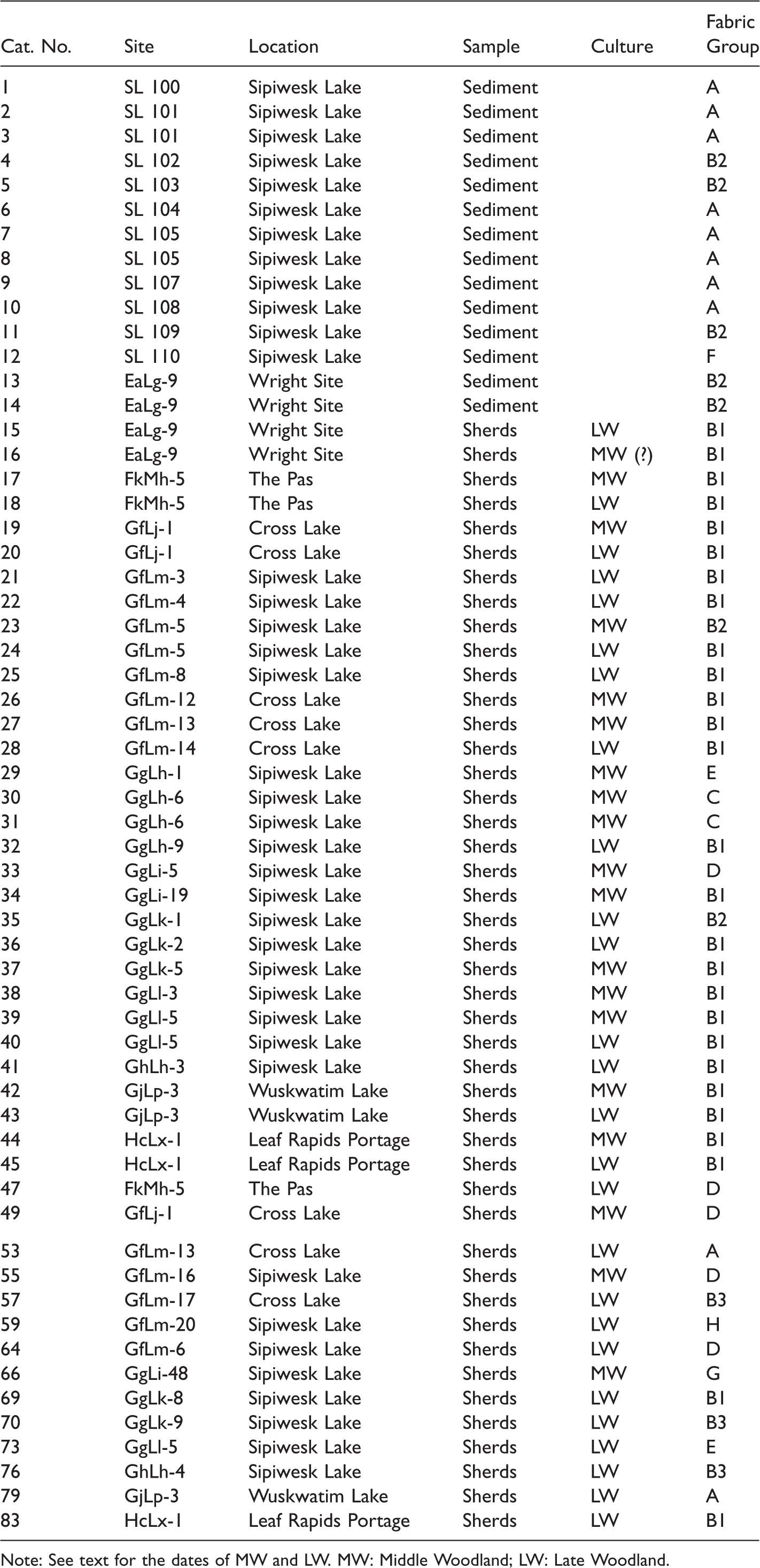
Note: See text for the dates of MW and LW. MW: Middle Woodland; LW: Late Woodland.
Archaeological pottery
Our archaeological sample includes 57 vessels from 31 sites (Table 2). A total of 29 sherds from as many discrete vessels were selected from 23 sites in the vicinity of Sipiwesk Lake (Figure 1(a)). On stylistic grounds, sherds fall within the Middle Woodland (n = 13) or Late Woodland (n = 16) periods (Syms, 2014). However, some may represent new ceramic expressions particular to the northern boreal forest (Skalesky et al., 2011). Nevertheless, all sherds could be placed within either period. For our purposes, it was enough to distinguish Middle from Late Woodland ceramics to assess any changes in procurement practices across this time frame.
To provide a regional perspective on the fabrics that characterize the Sipiwesk Lake Woodland pottery, we also analyzed an additional 28 vessels from nine other sites situated in the Superior Province and the Churchill Province (Figure 1(b)). Most of the comparative material is from sites in the Boreal Shield ecozone in order to provide insight into fabric variation within and between the two geological provinces. Immediately to the south of Sipiwesk Lake, we examined five vessels from four sites at Cross Lake. Spanning a large area of the Churchill Province to the west, we examined vessels from one site at Wuskwatim Lake (n = 3), Leaf Rapids Portage (n = 3), and The Pas (n = 3). Finally, we also included petrographic data from Burns’ (1994) study of Tulabi Falls. One other site, the Wright Site (EaLg-9), just north of Winnipeg along the Red River, sits in the Prairies ecozone.
Petrographic and XRD analyses
Archaeologists have adopted a range of methods to characterize the composition of ceramics to infer the source of raw materials used during manufacture. These methods identify either the nonplastic rock and mineral constituents of a ceramic body or the occurrence of different elements in major, minor, and trace amounts (Kennett et al., 2002; Pollard and Heron, 2008; Tite, 1999; Vandiver, 2001). Three analytical techniques were used in this study to classify sediment samples and sherds into compositional groups.
First, optical petrography was used for identifying the rock and mineral components of clay and sherd materials using cross-polarizing microscope. In addition to the identification of the mineral composition of clays and archaeological sherds, our petrographic analyses have also examined the rock composition, the proportion of nonplastic materials (minerals and rocks), and the properties of each grain in the entire observed matrix, which includes minerals, rocks, silt, clay, and voids. Optical petrographic analyses used the count method, whereby every grain is investigated. This method was chosen because nonplastic inclusions rarely exceed 25% of the sherd matrix in cross section. While optical petrography is the mostly widely used method in ceramic provenience analyses, observations can be limited to a single thin-section of a sherd wall from a single vessel. This is improved by combining the observations of thin sections from multiple sections of a vessel profile if they are available. Additionally, optical petrography does limit the accuracy of identifying clay mineral composition. For these reasons, each specimen was subject to oriented powder XRD.
XRD was utilized to determine bulk mineralogy and the mineralogy of the fine-grained clay fraction occurring in the matrix of all samples using a Philips PW1710 powder diffractometer. Thin sections were analyzed using a rotating anode with CuKα radiation and MDI Data Scan software. The results are compared to standards in MDI Jade 10.0 XRD software. This is a cost-effective and reliable method for identifying major and minor mineral constituents of a clay body. However, more abundant minerals can mask minor constituents (Fowler et al., 2011).
The third technique helps solve this problem. We used a scanning electron microscope (SEM) and electron micro-probe to identify minerals that may not have been detected using XRD and to identify the major element composition of clays and nonplastic materials. For these analyses, polished thin sections of crushed sherds were prepared. Carbon-coated thin sections were analyzed using a Cambridge Stereoscan 120 (SEM) equipped with a backscattered electron detector and an energy dispersive X-ray spectroscopy (EDS) detector with digital imaging. SEM was used to characterize fine-grained textural features, and EDS provided identification of mineral grains. The results of each analytical technique were then correlated to infer the geological origins of the ceramics through a comparison of clay samples with archaeological sherds.
Results
The analytical sample for this study involved five sub-samples: sediments from Sipiwesk Lake; archaeological sherds from sites around the lake; material from the outwash source; the composition of fired experimental tiles; and sherds from archaeological sites in the north-central, south-central, and south-eastern regions of the province. Specimens from each sample could be categorized into one of nine “fabric” groups based upon the correlated results of optical petrography (Tables 3 and 4), XRD analysis (Figure 3), and SEM analyses. The following two sections describe the nonplastic inclusions in the reference clays and fabrics and the clay minerals that were identified during analyses. Tempering material must be inferred from a comparison between pottery and clays and the nature of nonplastic inclusions in the pottery. This is taken up in the third section. The last two sections address the spatial-temporal distribution of the fabrics and the technical advantages of the variation in fabric compositions.
The mineral composition of clays (1,2), tempering material (F), and archaeological vessels referenced to develop a tempered clay body for the experiment.
Note: All three materials were classified into fabric groups. The compositions and matrix characteristics given for each group are composite results from optical petrography, X-ray diffraction, and scanning electron microscopy. See text for the dates of MW and LW. MW: Middle Woodland; LW: Late Woodland.
The matrix characteristics given for each fabric group following the guidelines of the Prehistoric Ceramic Research Group (2010).
Clay groups
Two clays were consistently found at every location in the eastern half of Sipiwesk Lake. The clays fall into two mineralogical groups: 1 and 2 (Table 1). Group 1 is a silty clay some 5 to 15 cm in thickness (dark brown when wet) and is comprised of quartz, albite, anorthite, microcline, calcite, dolomite, and muscovite. Mineral grains compose 5% to 10% of the matrix and range in size from fine to very coarse sand.
Stratigraphically below Group 1 around the lake is Group 2 clay. Groups 1 and 2 clays can be separated by a transitional layer of silty clay with pebble-sized grains (Figure 2). Group 2 clay is light brown in color with distinctive lamination marking sedimentation episodes that may be separated by occasional thin layers of silt. The clay is characterized by quartz, anorthite, montmorillonite, biotite, and muscovite, all in the fine to very coarse sand size ranges. Both XRD and SEM analyses produced results consistent with two sub-types of smectites (montmorillonite and nontronite) as the dominant clay minerals for both Groups 1 and 2 clays (Figure 3).

Shallow section showing clays sampled from Sipiwesk Lake. Group 1 (upper, dark brown), Group 2 (lower, light brown segmented by silt deposit).
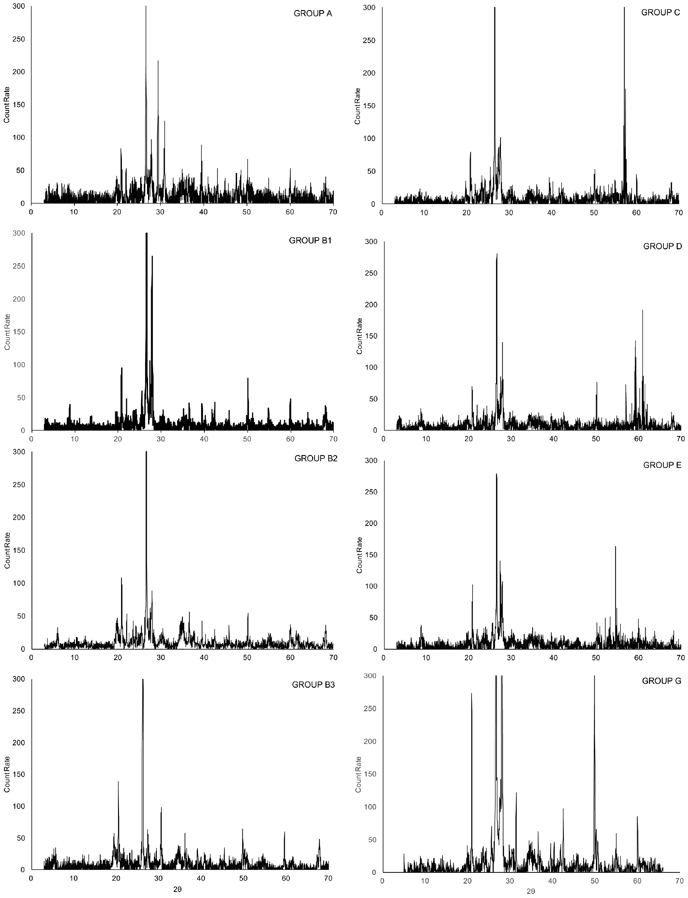
XRD spectrographs characteristic of each fabric group.
Group 2 clay is not restricted to Sipiwesk Lake. Clay samples from the bank of the Red River adjacent to the Wright Site (EaLg-9), just north of Winnipeg, also falls within this group. The wide distribution of this clay type is clearly unrelated to bedrock geology. The clay therefore represents the vast distribution of offshore glaciolacustrine sediments found throughout the province. We can expect pottery made using Groups 1 or 2 clays to be widely distributed at precontact sites across the province, which could complicate or inhibit distinguishing the geological provenance of pottery.
Pottery groups
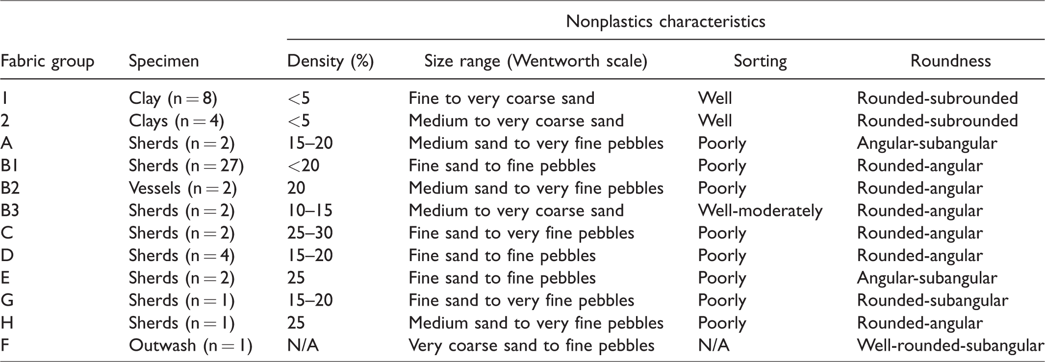
In this section, we outline the characteristics of each of the pottery fabric groups in terms of their mineralogy (Table 3) and four characteristics of nonplastics materials (density, grain size, sorting, and roundness) (Table 4).
Group A pottery is represented by a vessel from Cross Lake (GfLj-13) and one from Wuskwatim Lake (GjLp-3). The pottery has exactly the same composition as the Group 1 clay, with quartz, albite, anorthite, microcline, calcite, dolomite, and muscovite. Unlike the clay, however, inclusions are poorly sorted, makeup 15% to 25% of the matrix, and are dominated (84%) by angular to sub-angular coarse to very coarse sand (>0.25 to <2.0 mm) grain sizes. Large grains (>4.0 mm) are rare and sparse.
Group B1 only includes pottery, which is composed of quartz, albite, anorthite, apatite, microcline, plagioclase, olivine, magnetite, muscovite, and hornblende. Grains compose less than 20% of the total fabric. Sizes range widely, from fine pebbles to fine sand. Quartz grains form the majority of nonplastics, more than 83%, and fall in the coarse sand to fine pebbles sizes. Most quartz is rounded while the other, smaller-grained material, is comparatively angular. Grains are poorly sorted and tend to cluster either along the mid-line of the wall or spanning the width of the wall (see Figure 4(a) for same pattern in Group 2). The former grain orientation pattern is associated with drawing or molding shaping techniques and the latter grain orientation pattern is usually indicative of a coil remnant (Sanger, 2016; Thér and Toms, 2016).
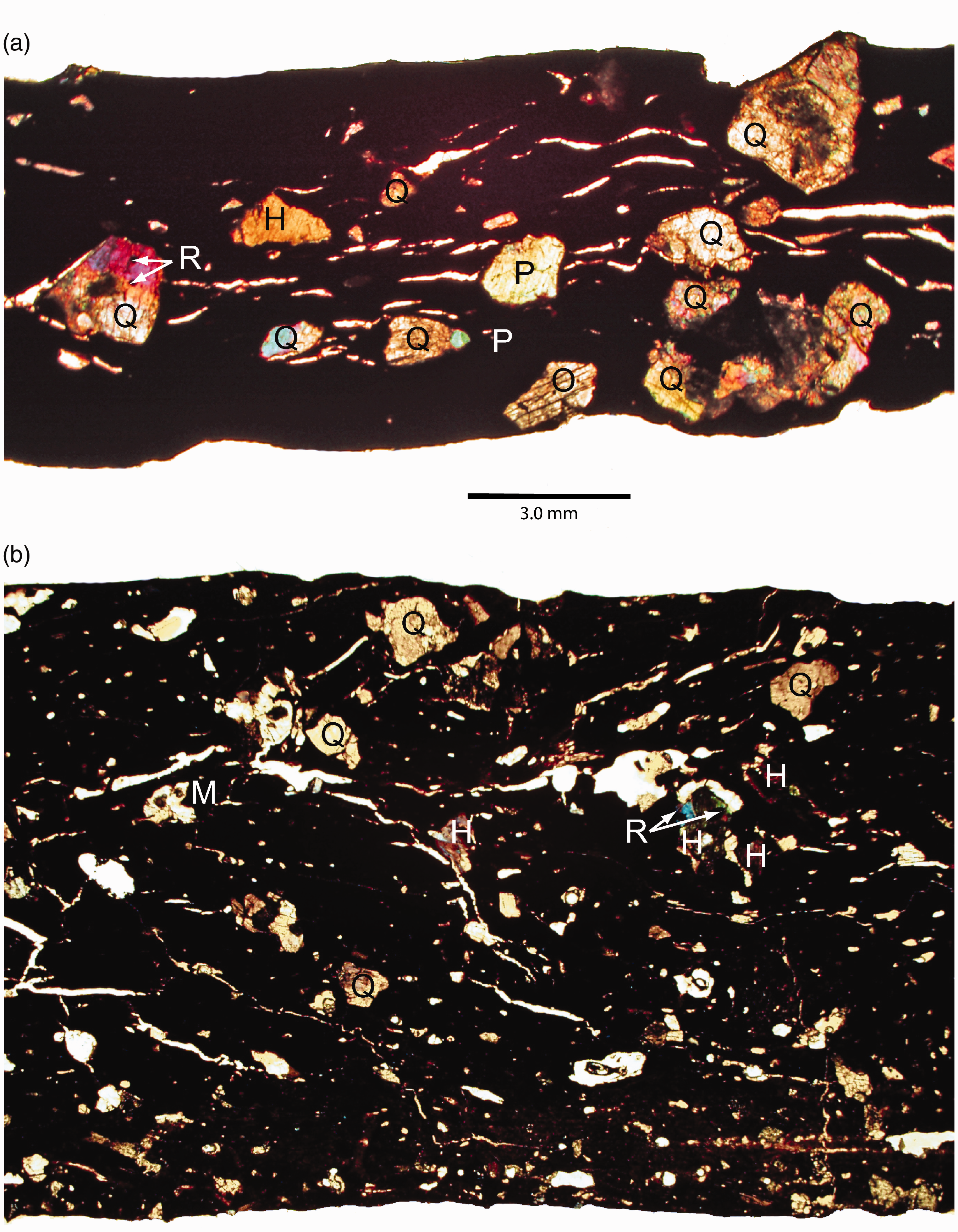
Thin-sections of Group B2 (a) and Group C (b) sherds showing main mineral constituents under cross-polarized light (40x). H: hornblende; M: muscovite; O: olivine; P: plagioclase; Q: quartz; R: rutile.
Group B2 vessels have the same mineral composition as that of Group 2 clay from Sipiwesk Lake and the Wright Site (EaLg-9). This group has a broad range of identified minerals including quartz, anorthite, plagioclase, biotite, olivine, muscovite, hornblende, rutile, and montmorillonite. Although the grains are similar in roundness and frequency to Group B1, few are larger than 2.0 mm (very fine pebbles). Grains make up 20% of the fabric and are poorly sorted. The same patterning of grains seen in Group B1 also occurs in Group B2 pottery (Figure 4(a)).
Group B3 is represented by quartz, montmorillonite, dolomite, and muscovite. Grains are similar in roundness and frequency to the other members of the B group, but the grain sizes are less than 2.0 mm, better sorted, and less dense (10%–15%).
Group C has the most complex mineralogy, with quartz, albite, anorthite, apatite, microcline, biotite, olivine, magnetite, K feldspar, Ca feldspar, muscovite, diopside, hornblende, pyroxene, and other unidentified amphiboles, rutile, and ilmenite (Figure 4(b)). Dominated by angular quartz, these minerals make up 25% to 30% of the matrix. Grains are smaller than the B Group, ranging from find sand to very fine pebbles in size (<0.5 to <4.0 mm) but most (68%) are in the medium to coarse sand range (>0.5 to <1.0 mm). Grains are poorly sorted.
Group D vessels are characterized by quartz, albite, anorthite, and muscovite. Most grains (90%) are sand sized (>0.25 to <2.0), angular, well sorted, and compose 15% to 25% of the matrix.
Group E vessels are very similar in composition to Group D, with quartz, albite, and muscovite, but they also have microcline. Grains range widely in size. Some grains are very large (<8.0 to >4.0), but most (80%) fall into the medium to very coarse sand range (>0.25 to <2.0), are angular or sub-angular, poorly sorted, and make up 25% to less than 30% of the matrix.
The Group G vessel is similar to Groups D and E. It has the least complex mineralogy, characterized by quartz, albite, and microcline. Grains are poorly sorted, usually rounded to sub-angular in shape, most grains (82%) fall into the coarse to very coarse sand sizes (>0.5 to <2.0), and they comprise 20% to 25% of the matrix. Like Group D, a few grains can be very large.
The single vessel in Group H has quartz, albite, tremolite, and actinolite. Grain sizes are most comparable to Group G, with most (75%) in the coarse to very coarse sand ranges (>0.5 to <2.0). Inclusions are poorly sorted and comprise less than 25% of the matrix. The diagnostic tremolite and actinolite are asbestiform materials of the amphibole supergroup that can be used for industrial asbestos and these are geographically restricted in Manitoba to Archaean-age geologies in the boreal forest region.
Temper and nonplastic inclusions
All pottery groups contain significant voids, fissures, and angular nonplastic inclusions. Most minerals in thin section exhibit angular edges or evidence that a larger grain has been shattered into smaller microfragments. Petrographic analysis of sherds from 33 vessels shows that most grains are coarse to very coarse sand in size (>0.5 to <2.0 mm length), range from highly spherical and very angular to aspherical and rounded in shape, and comprise 10% to 25% of the matrix (e.g., Figure 4). Rocks and minerals from the outwash were not angular and were comparatively larger (>1.0 to <4.0 mm in length) relative to nonplastics in pottery. If such material was used as a grit source for tempering pottery, it would have been crushed to create smaller fragments with angular edges. Both the low frequency and roundness of minerals in the raw clay bodies indicate that crushed grit material would have been added as temper to generate pastes for making pottery.
To further investigate clay processing practices, we produced experimental pastes using Groups 1 and 2 clays combined with naturally occurring grit material (water sorted sand and pebbles) from Sipiwesk Lake (Fowler et al., 2017a). Grit material from a lakeshore outwash at Location 110 (Figure 1) was used in that experiment.
Mineralogical analysis of the grit from the outwash, designated Group F, shows that the major minerals include quartz, amphiboles (e.g., magnesiohornblende), anorthite, diopside, ilmenite, magnetite, and olivine (Table 2). Apart from quartz, albite, and muscovite which appear to occur naturally in both the Groups 1 and 2 clay bodies, our experimental study found that mixing the Group 2 clay with the Group F grit generated a paste with a mineralogy represented in 97% (n = 32/33) of the sherds examined from the archaeological sites at Sipiwesk Lake and Cross Lake. The experimental paste shares major minerals with the members of Groups B1, B3, C, D, E, and G. Thus, the experimental paste is not a duplicate or reconstruction of the fabrics represented in the archaeological sample. It is instead a composite of multiple paste “recipes” identifiable in the archaeological sample.
The comparison of clay, grit, and experimental paste compositions relative to archaeological pottery compositions provides a starting point to distinguish whether pottery could have been manufactured “locally” or “nonlocally.” Relative to the experimental paste, the above groups (B1, B3, C, D, E, and G) could all be manufactured using “local” resources.
Spatial and temporal distribution of fabric groups
Given the pervasive use of clayey glaciolacustrine sediments across the province, it would be nearly impossible to determine what would constitute a “local” source, or “local” paste preparations, without a broader spatial sample of vessels from sites outside the Sipiwesk Lake area. To this end, we compared the spatial and temporal distribution of fabrics identified at sites beyond Sipiwesk Lake.
Spatial patterns
The spatial distribution of fabric groups from north-central, south-central, and south-eastern Manitoba sites fall into three categories: local, regional, and pan-regional (Figure 5).
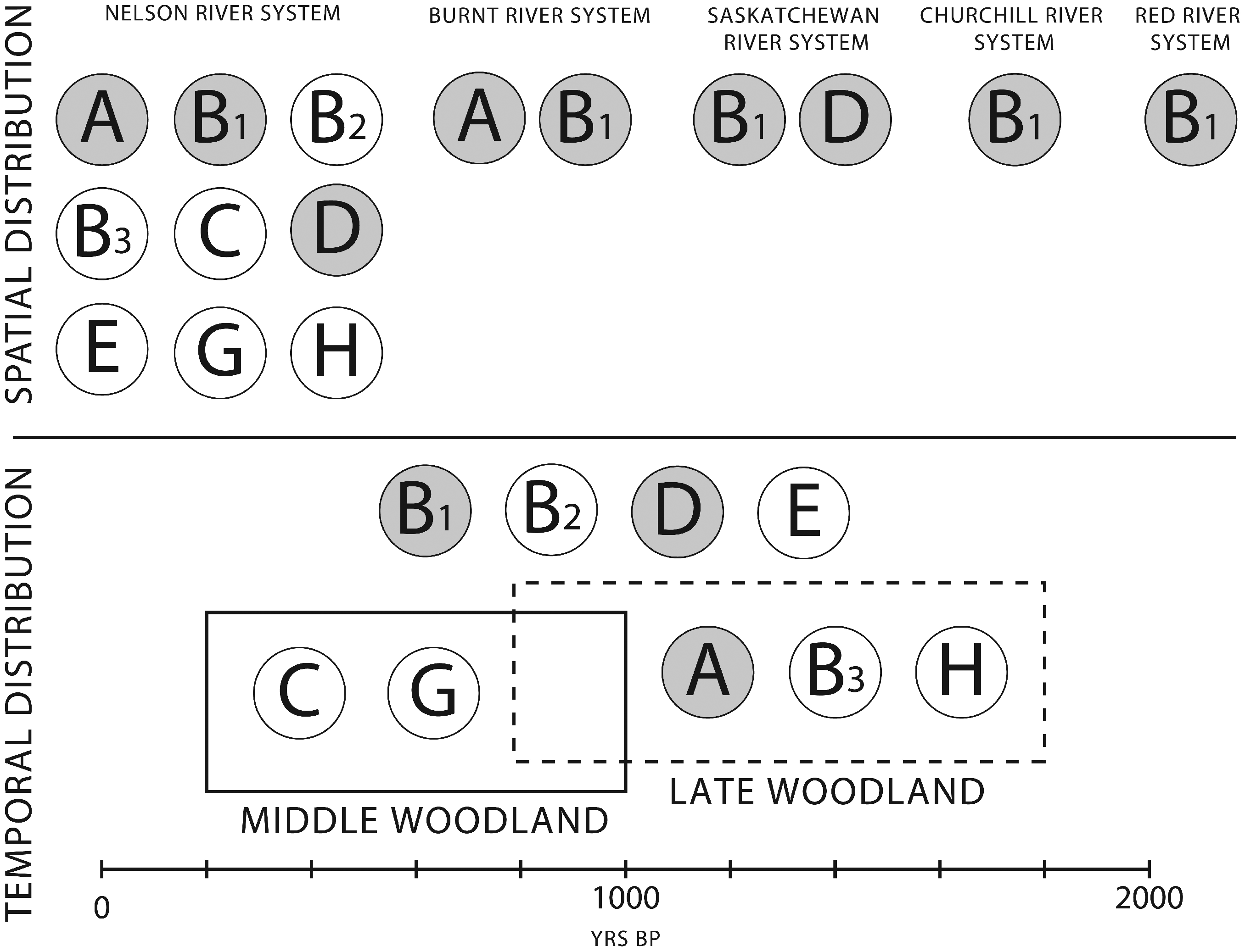
Spatial and temporal distribution of fabrics identified in the study. White circles represent fabrics that occur only at Sipiwesk Lake and Cross Lake.
Local groups occur across a geographically limited area defined in terms of hydrological boundaries, such as a lake or river section. Five of the nine fabric groups identified at Sipiwesk Lake occur exclusively at sites along the lake (Table 1). Groups B2 (n = 2), C (n = 2), E (n = 2), G (n = 1), and H (N = 1) do not occur at the nine other sites examined outside the Sipiwesk Lake area. The clays and sherd fabrics and the experimental pastes are dissimilar to Group H, which contains tremolite and actinolite. However, Group H could have been locally produced. According to Couëslan et al. (2012b: 88), “hydration of the mafic dikes locally occurred along joints and fractures” in the eastern half of the lake that “resulted in the growth of chlorite- and actinolite-rich assemblages.” Thus, we are confident that Groups B2, C, E, G, and H can be defined as local groups. Likewise, the fabrics identified at Tulubi Falls form their own local group because they share no members with fabric groups identified from elsewhere in our sample.
Regional groups include fabrics found across a larger area, spanning one or more places within a drainage. Interestingly, no Group A pottery was identified at Sipiwesk Lake although the clay is ubiquitous. Only one vessel from GfLm-12 at Cross Lake and another vessel from GjLp-3 at Wuskwatim Lake belong to Group A. It does not occur farther north than the Burnt River, or south of Cross Lake. Likewise, Group B3 occurs only at two sites along Sipiwesk Lake and one site a Cross Lake. Groups A and B3 are therefore regional groups.
Group B1 pottery is ubiquitous. It occurs at most every site outside Sipiwesk Lake and therefore can be considered a pan-regional group. This is the only fabric group that indicates a direct link among boreal forest sites and the boreal forest and plains regions. This group lacks any geologically distinctive “signature.” However, the presence of olivine in B1 pottery fabrics does suggest a mafic origin for clay sources, and, thus, a northern boreal forest origin, because the geology of the area does not consist of ultramafic rocks or altered amphibolite, and olivine-bearing sediments are transported short distances. In our sample, this zone stretches from The Pas in the west, to Sipiwesk Lake in the east, and north to Leaf Rapids Portage. This conclusion is further supported by pottery compositions identified at southern sites. Group B1 pottery is unlike pottery characterized at Tulabi Falls along the Winnipeg River (Burns, 1994), and it lacks the limestones west of the Red River drainage, or the components of the sandstones, shales, limestones in the southwest of Manitoba. Group B1 may involve pottery that was widely moved north and south and across the boreal forest, or it may involve a more symbolic use of northern clay by potters who had direct, or indirect, contact with each other across this zone.
Only one group does not fit these patterns. Group D occurs at three Sipiwesk Lake sites, one Cross Lake site, and at The Pas (FkMh-5). This is the only other fabric group that indicates a direct connection between the western and central boreal forest regions. However, there is nothing in the composition of Group D vessels that is distinctive enough to suggest manufacture at either The Pas or the Sipiwesk Lake region. North of The Pas site is a pocket of the intrusive Archaean terrane that also occurs around Sipiwesk Lake and along the Churchill/Superior Boundary Zone. To the south of The Pas site are the limestones and dolomites of the Red River Formation. Group D is notable mainly for what it lacks relative to Groups A and B2 clays; microcline and albite, in general, the calcite and dolomite of Group A clays, and the biotite of B2 clays. It is difficult to say that Group D pottery was made locally at The Pas or Sipiwesk Lake. Alternatively, it could be a “local” recipe in both locations, signaling that potters across the central boreal forest preferred clays with a mineralogy common in Archaean-aged metamorphosed plutonic rocks, tonalites, granodiorites, and mafic and intermediate intrusive and volcanic rocks. For these reasons, we consider it, at present, a regional group.
Groups A, B1, B3, and D are all found outside of Sipiwesk Lake area. Temporal analysis of the compositional groups helps to resolve questions of the contemporaneity of potential contact among people from these and other regions.
Temporal patterns
Our discussion of temporal patterns is limited to the Middle Woodland (200–1000 BP) or Late Woodland (700–1680 BP) phases broadly. The identified fabrics occur in either one or both of the phases (Figure 5).
Four groups (B1, B2, D, and E) are not temporally sensitive and occur at the Middle and Late Woodland components of sites. Only two (B2 and E) occur at Sipiwesk, one other (D) is represented at The Pas, and one Middle Woodland site (GfLm-6) and three Late Woodland sites (GfLj-1, GfLm-16, and GgLi-5) at Sipiwesk Lake. Group B1 occurs at sites in every river system we examined, except along the Winnipeg River.
The five other groups do appear to be temporally sensitive. Of these, two groups are restricted to Middle Woodland sites (C and G) and three to the Late Woodland (A, B3, and H). Three groups are local Sipiwesk Lake “recipes” (C, G, and H). The others are regional groups, found at Sipiwesk Lake and Cross Lake sites (B3), or Cross Lake and Wuskwatim Lake sites (A). This opens the possibility for investigating the correlation between the style of pottery and paste recipes.
Technical advantages of paste compositions
Experimental studies have shown that both grit and quartz-based tempers provide certain technical advantages, such as increasing workability, reducing shrinkage during drying and firing (contributing to a vessel’s strength), and stopping cracks from propagating after firing (one measure of a vessel’s toughness) (Hoard et al., 1995; Rice, 1987). Many of the nonplastic materials that comprise “grit” expand at a more rapid rate than clay and therefore increase the likelihood that pots will crack or spall during firing. This, in turn, impacts a vessel’s toughness and strength. The ability of a ceramic body to resist fracture when it contains microcracks (or fracture toughness; Kilikoglou et al., 1998), in turn, impacts a vessel’s strength (resistance to thermal stresses, such as cooking, or mechanical stress, such as dropping; Rice, 1987: 358). However, some experiments have shown that this effect can be controlled by keeping grit temper to 20% or less of the total paste composition (i.e., the processed clay body) (Hoard et al., 1995; Kilikoglou et al., 1998; Tite et al., 2001).
From a functional perspective, there is little to choose in how the major components of these paste recipes behave when subject to heat. Quartz, feldspars, and micas are dominant, and in any combination with minor constituents, such as amphiboles (e.g., tremolite), they would not provide some kind of technological advantage for potters. Likewise, mineral composition is always less than 30% of the fabric, a characteristic shared with the pottery studied at both Tulubi Falls and Lovstrom. Our experimental studies have shown that including more than 30% temper using boreal forest clays confers no technical advantage to potters (Fowler et al, 2017b). If fact, it is malproductive to increase temper beyond this proportion as it serves only to increase vessel weight and decrease strength.
Paste variety must be in part due to the culturally prescribed preferences of potters. But we would argue that paste variation is more strongly conditioned by the selection of tempering materials and not clays. Our question then is whether such paste variety could be generated within the resource areas regularly used by potters and the groups they belonged? This requires that we go beyond some of the restrictions of the CRAM about how far potters will travel to collect resources but carefully consider ethnographic work and historical sources that have taught us what could constitute a production unit in precontact societies.
A northern boreal forest ceramic resource area model
The CRAM attempts to explain and predict the spatial limits of energy expended to obtain resources and it has been used to identify communities of potters and infer patterns of exchange in both the Americas and in Europe (Arnold, 1981, 1985, 2005, 2006; Arnold et al., 1991; Neff et al., 1988). Here, we examine this model in slightly more detail by highlighting its two most important concepts.
The first is threshold distances. The threshold hypothesis predicts distances to ceramic resources (clay, temper, and pigments) in terms of the effort expended to obtain them. In a study of sedentary or semisedentary communities worldwide, it was found that 84% of potters obtained clay and temper within 7 km of where they live, and nearly half the sample collected within 1 km (Arnold, 1985, 2005, 2006). Arnold’s (2006) reanalysis of these data attempted to refine the threshold distances by comparing the percent of the sample against the log of the distances to clay and temper sources, as opposed to the percent of the sample that acquired resources at different distances. This resulted in a readjustment of threshold distances, whereby 37% of potters preferred acquisition within 1 km of where they live, 71% within 4 km, and 86% within 7 km. Although the log-distance transform produces thresholds that are more precise, the result remains the same: Potters will rarely travel more than 7 km to get clay or temper (Arnold, 2006: 6–7).
There are some rather practical reasons for this pattern. Clay is heavy, especially when moist or wet, so for many potters, distance is an important factor in the selection of particular extraction locations for clay within a broadly distributed source deposit. The maximum distance threshold correlates with how far sedentary peoples will usually travel to commonly used resources.
More recently, the threshold hypothesis has been given a deeper social dimension using a second concept, the community of potters (Arnold, 2006). This is the production unit that procures raw materials within the threshold distances. Members of these communities tend to interact more with each other than other communities of potters and thus produce a similar repertoire of ceramics both in terms of style and manufacturing methods. Communities of potters are an ethnographic reality (Fowler, 2008, 2011, 2015; Fowler et al., 2011; Gosselain and Livingstone Smith, 2005; Thebe and Sadr, 2016), but few ethnoarchaeometry studies have been purposefully designed to link ceramic composition with communities of potters (Arnold, 2005; Fowler et al., 2017b; Middleton, 2012).
The inclusion of potters as a community of practitioners and knowledge keepers is an important addition to archaeological thinking about pottery resources. Parallel to considering potting communities as the real social entity of our interest is the notion that choices made during production are embedded in broader social strategies offers a very useful perspective to interpret variation in production behaviors (Gosselain, 1998, 2000, 2002; Hegmon, 1998; Sall, 2001; Stark, 1998, 2003). The known relationships between potting and other activities cross-culturally provide a powerful rational for building a set of expectations about resource procurement based on the range of activities people undertake, regardless of how mobile they are, when precise data on ceramic resources procurement is unknown or poorly documented in descendant communities.
Ethnographic data for hunter-gatherers and agriculturalists do suggest some significant differences in resource procurement distances. Browman (1976) summarized much of these data and showed that collecting distances for women do not go beyond 5 km from camp unless it is a period of crisis. Hunters, in contrast, may travel as far as one day from camp, around 20 to 35 km. For farmers, walking distances to fields is around 1 km, but no more than 4 km (Chisholm, 1979). Based on these and later data, site catchment studies estimate a 2-hour walking distance for hunter-gatherers and a 1-hour trip to fields for farmers when traveling to commonly used resources, such as collecting food or tending crops (Higgs and Vita-Finzi, 1972; Jarman; 1972a, 1972b; Kohler, 1992; Kruse, 2007; Preucel, 1987, 1990).
Considering the available data for the routine acquisition of resources by peoples who practice high mobility in general, and in northern Manitoba in particular, we can establish a working model of preferred distances that would be travelled by mobile peoples to obtain pottery-making resources.
First, we must return to Brandzin’s (1994) study. Her work showed that most pottery must have been made using clays from indeterminate sources further than 16 km from the site. These findings could easily be generalized outside the plains ecozone to erroneously interpret pottery made from “nonlocal” clays as evidence of trade in ceramics. However, historical and ethnographic data indicate that potters may have obtained clay from a number of activity locations: seasonal camps, along paths and trails, and resource harvesting sites (Malasiuk, 1999). Since travel by canoe was preferred during warmer months when pottery would be made, clay and/or temper may have been moved considerable distances before being manufactured into vessels. For any given “community” of potters, which could be occupying a single site or close group of conterminous settlements, there would be preference for obtaining clay and temper within 5 km. Assuming that both men and women would have the knowledge to identify and assess acceptable clay and tempering material (e.g., Fowler, 2008), resources further away could be collected during regular hunting trips, fishing, while checking trap lines, or when harvesting other resources such as wild rice (Oetelaar and Meyer, 2006). Seasonally, such regular forays would occur within 30 to 40 km of the community, especially when using waterways. If clay and/or temper were not available within the range of other regular seasonal activities, it becomes more likely that they were acquired from another catchment. The implication for provenience analyses is that pottery recovered from a site could be made from (1) local (<30 km of a site) clay and local temper, (2) local clay and nonlocal temper, (3) nonlocal clay and local temper, or (4) nonlocal clay and nonlocal temper. Despite the variability in mineral temper for Woodland pottery in Manitoba, and its sensitivity to distinguishing local, regional, and pan-regional fabric recipes, none of these potential scenarios will affect our ability to distinguish the geological origin of a vessel’s composition. They do complicate how we would explain the variation in paste recipes represented by the pottery assemblage at a particular site.
The latter problem—defining what could be made using resources within 30 km of a settlement—is one that can only be addressed by working at a regional scale and not the level of a site or cluster of sites. If we expand the potential resource range beyond 7 km, and 16 km, to 30 km, does this help explain paste variety in one region and between regions? Hypothetically, using a 30-km range, communities of potters can be identified when the distance between them is twice the threshold distance between areas, that is, in this case, twice the radii of 30 km between resource areas, or 60 km. When we apply a revised threshold range of 30 km to our northern boreal forest areas (Figure 6), we can observe two major patterns.
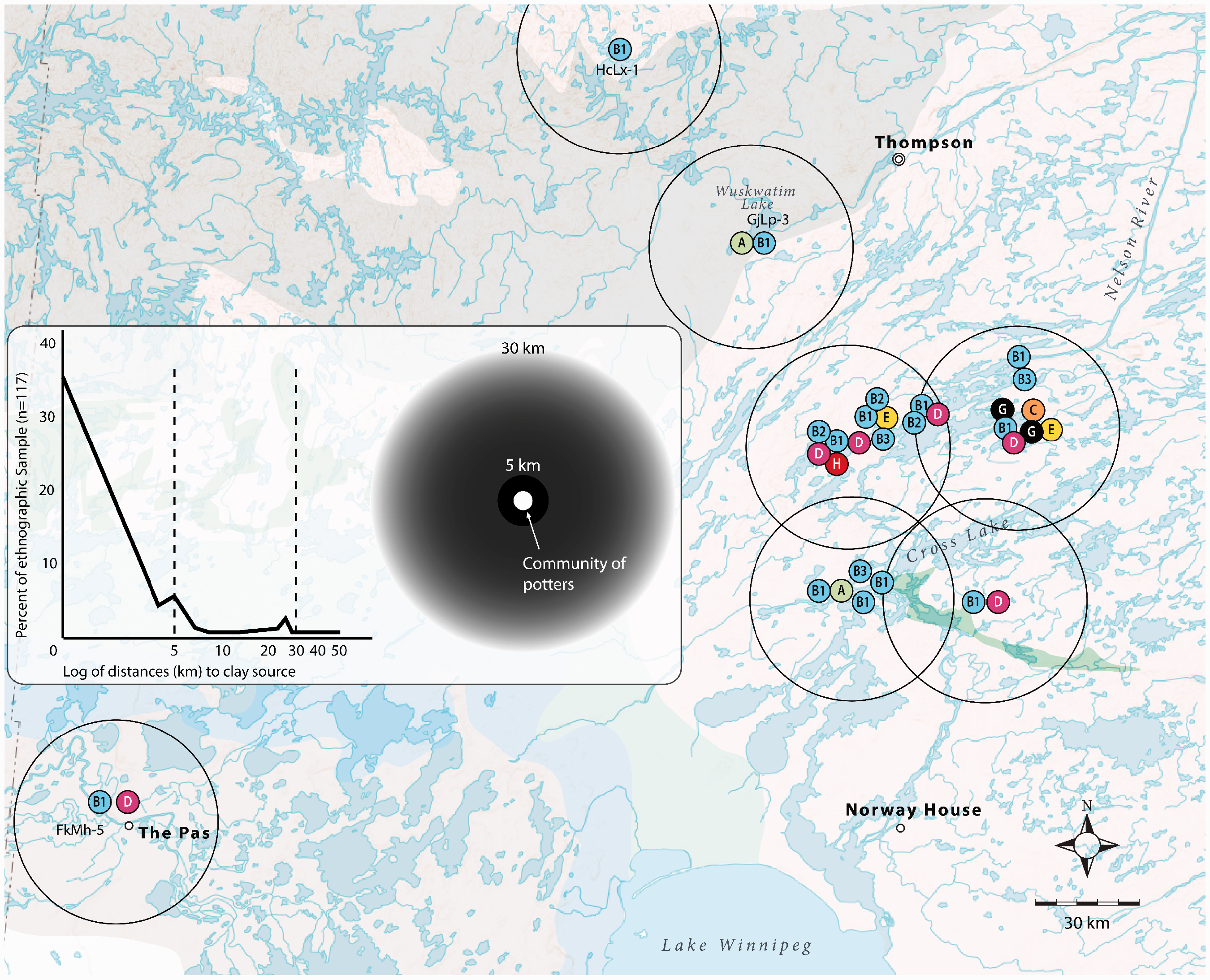
Application of a modified CRAM to the north-central boreal shield of Manitoba. The circles are 60 km in diameter. For clarity, circles are centered in the middle of site clusters at Sipiwesk Lake and Cross Lake.
First, we see that resource areas significantly overlap between Sipiwesk Lake and Cross Lake. It therefore more likely that these areas will share fabric types. These ranges help explain the broad distribution of certain fabric types (B1, B3, and D). Groups B and D fabrics have a vast distribution because the resources required to make this paste are nearly ubiquitous.
However, both Group B1 and D are suspicious for the generic simplicity of their paste composition. Both B1 and D have the mineralogy of a granite. However, B1 also contains olivine, which we argue is from a mafic source. Most northern boreal forest sites examined in this study have mafic geologies within 30 km (The Pas, Leaf Rapids Portage, Sipiwesk Lake, Cross Lake, and Tulubi Falls). Other sites in the boreal forest are not near mafic geologies but have Group B1 vessels (e.g., Wuskwatim Lake).
Because these groups lack mineral components that could help define their geological origin, we can suspect cultural forces at play during the manufacturing process. This is potters at work, removing or adding components from clays to make paste recipes that can service vessels put to multiple functional requirements. It is also possible that clays derived from different geologies were mixed to create the pastes we identified as B1 and D. Such processing strategies profoundly alter the source material, making it extremely difficult to define the geological origin of pottery based upon mineralogy alone. We have found in the study of ethnographic pottery that chemical analyses are more sensitive to discerning clay mixing strategies used to make pottery; although it is very difficult to assign pottery to a known source material, mixed-paste pottery is distinguishable at a regional level from those manufactured using different geological sources (Fowler et al., 2017b).
Second, we also see a more highly restricted distribution of other fabrics despite the overlap of resource areas (B2, C, E, G, and H). We can posit that these are truly local recipes, particular to a time (C, G, and H) and place (E). At present, we can consider these local Sipiwesk Lake fabrics, just as we can consider those at Tulubi Falls local fabrics. One consequence of the overlap of resource areas is that it is not possible to identify distinct “production communities” in an ethnographic sense because potters could be obtaining raw materials from the resource area exploited by another community of potters situated within 60 km (cf. Arnold, 2005: 17–18).
Our data indicate that “production communities” defined in terms of fabrics may cover quite a large area. In reality, the sites represent a palimpsest of settlement in an area and are not always or necessarily coterminous. We cannot assume that vessels made in one or a few places were transported to others. Movement of vessels can only more confidently be inferred when fabrics are found in an area that is deficient in the resources required to make them. For instance, further research may test the hypothesis that Group B1 vessels at Wuskwatim and Group D vessels at The Pas are “imports” in the sense that the vessels were made elsewhere and brought to the settlement where they were recovered (not implying that they were traded or “bought”). Our data indicate that people living in the boreal forest may have not found it worthwhile to transport pottery at all, or very far, when it could just be made prior to settling into a summer or winter camp. In other instances, some pottery may have been worth hauling along, as some fabrics in the north (Group D and E) and from the Lovstrom site attest. This means that to infer mobility and resource use, it may be vital to triangulate pottery manufacturing practices, style, and function.
Conclusions
The aim of our study was to characterize the mineral composition of pottery from Sipiwesk Lake in northcentral Manitoba to better understand how people gained the resources they needed to make and use one of the most durable pieces of equipment in their technological repertoire. We were able to identify nine distinct fabrics, which can be considered “paste” recipes, produced by potters living in the environs of Sipiwesk Lake between 1800 and 300 years ago.
Rather than distinguishing spatially restricted fabrics that would suggest a series of localized manufacturing areas, we were able to identify pottery fabrics that have local, regional, and pan-regional distributions by examining vessels at other sites across the boreal forest ecozone and the prairie ecozone to the south. Local and regional distribution patterns redefine what “local” production means for mobile hunter-gather communities when previous interpretive models are altered to consider the distances people will travel for the range of activities they undertake on a routine and seasonal basis.
We further suggest that potter’s practices served to add and/or remove nonplastics from raw clays but often retained naturally occurring minerals in trace amounts in fabrics. Such paste preparation techniques can frustrate pottery provenience analysis. And it is for this reason, we urge further research on the production of experimental pastes and the application of geochemical analyses to precontact Manitoba pottery. The finer resolution offer by geochemical analyses may serve to address the issues involved in identifying local pottery production in glacial till environments, rather than assuming that broadly distributed fabrics must be explained by exchanging pottery containers across vast distances. These petrographic and historical data challenge exchange as an explanation for the broad spatial distribution of the same fabrics. As we have attempted to show, the large areas exploited by precontact peoples during regular and routine subsistence activities are alone enough to explain why common pottery compositions would be found in sites at multiple lakes covering over 700 km2.
Footnotes
Acknowledgments
The authors are indebted to the people of Cross Lake First Nation, the Historic Resources Branch of the Province of Manitoba, and the University of Manitoba for supporting the research upon which this study is based. In the field, the authors are particularly indebted to George McKay (Cross Lake First Nation) and Scott Birse (Historic Resources Branch). In the lab, the authors would like to thank Neil Ball and Dr Frank Hawthorne for providing assistance and access to the XRD facility at the University of Manitoba and the assistance of Talisha Chaput, Oksana Hudson, and Robyn Neufeldt.
Declaration of Conflicting Interests
The author(s) declared no potential conflicts of interest with respect to the research, authorship, and/or publication of this article.
Funding
The author(s) disclosed receipt of the following financial support for the research, authorship, and/or publication of this article: Funding for the study was provided to KF and MF through the University of Manitoba University Research Grants Program, and by Canada Research Chairs in Environmental and Isotope Geochemistry and a Discovery Grant to MF from the Natural Sciences and Engineering Research Council of Canada.