
Abstract
This paper investigates the distribution of and motivations for zoning decisions that decreased allowed residential density or prevented denser residential development in urbanized portions of Durham, North Carolina, from 1945 through 2014. It presents quantitative evidence that prior to 1985, racial demographics offer a better explanation for the distribution of these potentially exclusionary decisions than median incomes or homeownership rates. This finding is substantiated by qualitative evidence from plans, records of public hearings, and other primary materials pertinent to zoning decisions affecting residential land use. The paper secondly presents evidence that since 1985, the city has made residential zoning decisions that have collectively entailed less dissimilar treatment of areas of different racial characteristics, and suggests reasons for this shift based on further research of primary materials. These findings inform us of the role of racial bias in zoning beyond the era of explicit racial zoning in the early 20th-century.
Introduction
Scholars have detected a relationship between high levels of metropolitan racial segregation and local zoning practices that restrict the construction of denser, multi-family housing (Pendall, 2000a; Rothwell, 2011; Rothwell and Massey, 2009). However, while we know that so-called exclusionary zoning occurs, it is difficult to say whether it is motivated by race, as governments avoid making statements of racially discriminatory intent when they make decisions with exclusionary impacts (Fischel, 2004). One can argue, as it is often the case, that cities make effectively exclusionary decisions for reasons having nothing to do with race: communities may restrict residential development density in order to prevent increases in traffic, for example. This ability to attribute exclusionary outcomes to race-neutral practices is at the root of historical failures to successfully challenge these activities in court (Berry, 2001; Rothwell, 2011).
This ability also makes it difficult for theorists and historians of zoning to discuss the role of race beyond the era of explicit racial zoning in the early 20th-century. For example, the “homevoter hypothesis” (Fischel, 2001), likely the most compelling contemporary theory of zoning, pays scant attention to the role of race in decisions superficially driven by homeowners’ concern over property values. This is less the fault of the author, however, than of the lack of empirical evidence of the role of race. But taking the apparently rational defense of homeowners’ self-interest at face value overlooks possible dynamics of implicit bias and downplays any professional responsibility planning practitioners and scholars may have to create greater equity via zoning practice. It is especially important at this time to reconsider the possible disparate impacts of zoning policies as well as the motivations for any disparity given the recent federal and judicial developments of Inclusive Communities (2015) and HUD’s (2015) “Affirmatively Furthering Fair Housing” rule, both of which reinforced the Fair Housing Act’s (1968) emphasis on rooting out the various causes of housing segregation.
This paper considers three types of zoning decisions that occurred in areas of Durham, North Carolina of over 500 persons per square mile (PPSM) from 1945 through 2014: upzonings of residential property, downzonings of residential property, and refused upzonings of residential property. The paper associates the latter two decision types with exclusionary effects: scholars (Glaeser and Ward, 2009; Pendall, 2000a; Rothwell and Massey, 2009) have presented evidence that land use regulations discouraging denser residential construction are effectively exclusionary, as they discourage the entrance of middle or lower-income households, and therein many minority households, into the areas where they occur.
The paper asks: (1) whether there has been a disparate impact of the three types of zoning decisions between communities of different racial, income, and homeownership characteristics, and (2) what intentions produced any observed disparity in the distribution of these decisions. The paper presents quantitative evidence that before 1985, (1) downzonings occurred in areas that were significantly Whiter and with a significantly higher homeownership rate but not significantly higher-income than average, (2) that refused upzonings occurred in areas that were significantly Whiter and with significantly higher homeownership rates but not significantly higher-income than average, and (3) that both downzonings and refused upzonings occurred in areas that were significantly Whiter but not with significantly higher incomes or higher homeownership rates than the areas where upzonings took place. These findings together suggest that other possible drivers of exclusionary zoning practices (higher incomes and higher homeownerhip rates) offer less likely explanations than racial prejudice in causing exclusionary practices prior to 1985 in Durham. The paper also presents quantitative evidence that since 1985 there has been less dissimilar treatment of areas of different racial characteristics. This alone may only be circumstantial evidence of historical racial bias in zoning practice. Therefore, I also conducted an empirical analysis of contemporary planning documents, Planning and Zoning Commission and City Council hearing minutes, and other materials relevant to residential land use decisions in order to substantiate the quantitative evidence and suggest reasons for the observed change in Durham’s practices over time. The paper thus frames historical zoning practice as a matter in part of preserving economic and social privilege for Whites at the expense of communities of color, well after the demise of racial zoning elsewhere in the United States.
Zoning and residential segregation
Scholars and planning practitioners have long viewed zoning as a means of creating residential areas in which home owner–occupiers are protected from the socially and economically destabilizing consequences of uninhibited property use. Fischel’s (2001) “homevoter hypothesis” argues that zoning decisions reflect the priorities of these home owner–occupiers. Home owner–occupiers support legislators who use zoning to discourage disamenities to residential living and preserve the quality of services including schools, parks, and other facilities. It is therefore logical to Fischel (2004) that zoning spread rapidly in the 1920s during the United States’ first great suburban boom. Suburban municipalities could use zoning to deflect environmental disamenities such as industry. They could also use zoning to deflect renters: suburban homeowners feared that these generally lower-income households would take advantage of local schools and other services without providing adequate tax revenue to support these services.
There is also a lengthy story of racial and ethnic prejudices informing zoning practice and its predecessors. In the 1880s, cities in California began to limit the areas where laundries could operate for the stated purposes of protecting property values and preventing fires (Pollard, 1931). Many laundries owned by Chinese newcomers to California also served as social venues for the new immigrants (Young, 2004). For a time, courts upheld the ordinances because of their apparent neutrality in regards to race, but the US Supreme Court ruled against them when it considered how often officials enforced the laws against Chinese-operated laundries relative to White-operated ones (Kosman, 1993).
In the early 20th-century, as African-American migration to the United States’ cities intensified, urban Whites wishing not to share schools and other facilities began to leave the neighborhoods where African-Americans settled (Bruce, 1926). Baltimore implemented a so-called “racial zoning” ordinance in 1910 that made it illegal for African-Americans to live or assemble on majority White blocks and vice versa (Taylor, 2014). The city explained that the purpose of the ordinance was to protect property values and to prevent conflict and disease (Silver, 1991), and other Southern cities followed Baltimore’s lead and established their own racial zoning ordinances. The US Supreme Court overturned racial zoning in Buchanan v. Warley (1917) because it had prevented a White Louisville man from selling his property in a White zone to an African-American buyer (Sager, 1969). Nevertheless, some southern cities pursued racial zoning into the 1940s (Silver, 1991). While most northern cities did not pursue racial zoning, racial and ethnic hatreds motivated their zoning of land uses. New York’s, 1916 zoning ordinance stemmed in part from Fifth Avenue retailers’ desire to halt the encroachment of garment factories and the Southern and Eastern European workers they employed (Hirt, 2014; Toll, 1969). The early history of zoning reminds us, then, of how cultural conditions including racial and ethnic hatreds inform conceptions of property value.
By the 1920s, exclusive zoning for detached single-family homes was standard practice. The US Supreme Court upheld the separation of residential densities via zoning in 1926 (US Supreme Court, 1926), and practices preserving low densities and other exclusionary practices proliferated during the postwar suburban boom. In 1967, 99.2% of the undeveloped land zoned for residences in the New York metropolitan area was designated solely for single-family construction (Downs, 1973: 49). By that time exclusionary zoning was such a well-known phenomenon that Lyndon B. Johnson’s National Commission on Urban Problems (1968) presented a list of contributing factors including large-lot zoning, bans on mobile homes, exclusion of multiple-dwelling units, and minimum house-size requirements.
Pendall (2000a) has since demonstrated the relationship between exclusionary land use controls and racial segregation, showing that zoning discouraging rental unit construction indirectly promotes racial segregation. Rothwell and Massey (2009) similarly found that metropolitan areas that became more racially integrated between 1980 and 2000 were those where local governments allowed denser development. However, as Pendall explained: “Although land use controls have evident connections with the exclusion of Blacks and Hispanics, the mechanisms through which these effects occur are not straightforward. Land use controls are not signs that advertise ‘Whites only’” (2000a: 138).
It is true that cities adopt effectively racially exclusionary measures to achieve environmental protection, prevent traffic congestion, and for any other number of reasons having apparently little to do with race. Often, however, local communities or governments can easily hide racist intentions behind less controversial statements, as Clingermayer (2004) has described. Communities may favor racial segregation and achieve it to a significant degree while never making their goal explicit: they simply introduce density controls ostensibly for other purposes. Those participating in the planning process may also disguise their intent using coded phrases for racial and ethnic minorities such as “subsidized housing,” “welfare cases,” or “unemployed” (Danielson, 1976: 90).
Consequently, one does not need to be explicitly racist to defend segregation. As Connor (2014) explained in his discussion of municipal fragmentation, suburbanites can defend segregation as consumers, homeowners, and taxpayers rationally guarding their property values and quality of life. In its 1977 review of effectively exclusionary zoning practices in Village of Arlington Heights v. Metropolitan Housing Development Corporation, the US Supreme Court established that an apparently discriminatory impact could not constitute a violation of the equal protection clause because the plaintiffs had failed to also demonstrate that Arlington Heights possessed discriminatory intentions (Berry, 2001). The Southern Burlington County NAACP v. Township of Mt. Laurel cases (NJ Supreme Court, 1975, 1983) ruled against exclusionary practices on the grounds that access to housing is a component of the general welfare (promoting the general welfare justifies the use of zoning according to state enabling legislation) and not on the basis of a violation of the United States constitution’s equal protection clause (Young, 2004).
Local governments may develop zoning practices that more effectively address the interests of traditionally underrepresented groups if these groups gain political stature. Hinds and Ordway (1986) found that rejection rates for rezoning requests historically differed between heavily White and heavily African-American census tracts in Atlanta, but that this disparity shrank as African-American political representation increased. But barring the diversification of local legislatures outside of central cities and other jurisdictions with large communities of color, the possibility of more equitable zoning practices at the metropolitan scale may be unlikely.
Recent federal and judicial developments carry significant implications for local zoning practice. In Texas Department of Housing and Community Affairs v. Inclusive Communities Project (US Supreme Court, 2015), a challenge to the Texas Department’s location of low-income housing units, the Supreme Court ruled that disparate impact theory was an available method of proof under the Fair Housing Act of 1968. This case thus sidestepped the issue of discriminatory intent, and reinforced the nearly 50-year old disparate impact doctrine of the Fair Housing Act. Also in 2015, the Department of Housing and Urban Development established an “Affirmatively Furthering Fair Housing” rule that requires recipients of HUD funds to examine local barriers to integration. These developments underscore the continuing salience of race in zoning and other housing and development policies, regardless of whether actual bias can be proved.
Research method
This paper analyzes three different types of residential zoning decisions occurring in urbanized sections of the city of Durham, North Carolina over seventy years. All zoning categories explicitly designed for residential use (including mixed use zones) have always stated a maximum residential density allowed in terms of residential units per acre, and I used these densities to understand if decisions constituted “upzonings” (rezonings to allow for greater density) or “downzonings” (rezonings capping development at a lower density). Many commercial, institutional, and other types of zoning categories have also allowed residential use, but because the city did not specifically create these zones or place them on zoning maps to accommodate residential development, they are not considered in this paper.
The paper considers Residential Upzonings (n= 341), entailing the rezoning of any residentially zoned land for denser residential use. It secondly considers Refused Residential Upzonings (n = 91), which involve refusals to rezone any residentially zoned land to a denser residential zone. And it considers Residential Downzonings (n= 108), which entail the rezoning of residentially zoned land for less dense residential use. I only considered decisions occurring within census tracts of over 500 PPSM, as I will explain below. Following from the work of Pendall (2000a), Glaeser and Ward (2009), and Rothwell and Massey (2009), which associated exclusionary effects with lower allowed densities, I associate residential downzonings and refused residential upzonings with exclusionary effects.
Within the record of each decision there was always either an address, physical description, or parcel tax identification number that I could use to locate a modern address of the affected parcel. Using ArcMap software, I mapped the location affected by each decision onto a Durham census tract map from the nearest decennial census. I thus divided the records of each zoning decision type into seven ten-year periods (1945–1954, 1955–1964, 1965–1974, 1975–1984, 1985–1994, 1995–2004, and 2005–2014), each of these periods having a decennial census at its midpoint. I then, for each decade, compared the average percentage of residents who were White and the average median household income in all Durham census tracts of over 500 PPSM to the average percentage of residents who were White and the average median income in: (1) all Durham census tracts of over 500 PPSM, weighted by the number of residential upzonings that happened in each, (2) all Durham census tracts of over 500 PPSM, weighted by the number of refused residential upzonings that happened in each, and (3) all Durham census tracts of over 500 PPSM, weighted by the number of residential downzonings that happened in each.
Comparing the citywide average tract (excluding tracts of under 500 PPSM) to the average tract where a given type of decision happened tells us about the types of areas where that type of decision happened, but it does not explain where residential downzonings and refused residential upzonings happened vis-à-vis residential upzonings. If, for example, residential upzonings, residential downzonings, and refused residential upzonings all occurred in similarly Whiter-than-average areas, it would be hard to suggest that Whiter-than-average areas have on the whole been the sites of exclusionary zoning practices. It was therefore also necessary to compare the average tract where residential upzonings occurred to the average tracts where residential downzonings occurred and the average tracts where refused residential upzonings occurred.
Many residential upzonings simply reflect the initial urbanization of land within Durham’s rural fringe: Durham expanded from 15.5 to 108 square miles over the period of analysis through the annexation of abutting rural areas. Meanwhile, exclusionary decisions are more characteristic of established neighborhoods wishing to prevent further intensification: research from across the period of investigation (Babcock, 1966; Pendall, 2000b) discusses opposition to new housing as resulting from residents’ wishes to protect the quality of established urban services and amenities. Therefore, comparing the average areas where residential downzonings and refused residential upzonings occurred to the average area where all residential upzonings occurred – many of which were in essentially undeveloped, rural areas – is not appropriate. The US Census Bureau (2002) has defined urbanized areas as core block groups of over 1000 PPSM along with adjacent block groups of over 500 PPSM. Others (Paulsen, 2012, 2014) consequently also use the threshold of 500 PPSM for measuring the extent of urban areas. Because block group data was not available for all years, this paper examines decisions in census tracts of 500 or more PPSM.
I weighted the comparison average tracts (i.e. the average tract where residential upzonings happened, the average tract where refused residential upzonings happened, and the average tract where residential downzonings happened) by the number of decisions that happened in each because it would not be consistent with residents’ experiences to treat a tract experiencing a single action in a decade the same as a tract experiencing five decisions in a decade. I also weighted by population while calculating the racial, income, and homeownership characteristics of the citywide average tract and the comparison average tracts in order to prevent over- or underemphasizing the experiences of residents in high or low population tracts.
I was interested in the percentage of residents who were White in order to understand the racial characteristics of areas where different decision types happened. It was also important to consider median household income and homeownership rates: because people of color have been lower-income on average and less likely to own a home than Whites in Durham, I needed to consider the possibility that some apparent disproportionate concentration of zoning decisions in more or less White areas may have been attributable to class. The National Historic Geographic Information System Version 2.0 (Minnesota Population Center, 2011) was the source for all demographic information and census tract maps.
For each decade, I conducted one-tailed difference of means tests to find when the median income, homeownership rate, and percentage of residents who were White in the citywide average census tract were significantly different from the median income, homeownership rate, and percentage of residents who were White in each of the comparison tracts. I also used one-tailed difference of means tests to compare the median income, homeownerhip rate, and percentage of residents who were White in the average tract where residential upzonings occurred to the median incomes, homeownership rates, and percentages of residents who were White in the average tracts where downzonings and refused upzonings occurred. I assumed that a statistically significant difference between the characteristics of any two average tracts indicated that there was a disparate impact of these decisions across different types of areas.
The second component of my research method involved an empirical review of records of public hearings, planning documents, and other primary materials having to do with the investigated types of rezonings. The qualitative evidence highlights possible motivations for pursuing decisions of one type or another, and also reveals apparent inconsistencies in the treatment of similar cases in areas of different demographic characteristics. While I could not confirm the racial identity of all decision proponents and opponents speaking at public hearings on decisions in mixed-race neighborhoods, 1940 census data and other material available through Ancestry.com allowed me to do so often. Records of hearings did not always include comments from residents or council members (perhaps because there was not always discussion), and so a comprehensive analysis of stated reasons for every rezoning was not possible. I often turned to planning publications and academic research contemporary to many decisions to infer reasons for observed trends such as a cluster of downzonings in core neighborhoods, or a geographical concentration of upzonings for public housing. I have made an effort to cite the bulk of cases in which discussion centered upon the type, quality, or presumed occupants of any construction that could occur as a result of proposed rezonings, as these cases are the most obviously pertinent to any investigation of possible racial bias.
Most significantly, a review of the more substantive hearings and available planning documents revealed the emergence of two trends in the mid-1980s that altered the city’s approach to zoning: a push by residents to conserve older, core neighborhoods and the efforts of the city’s newly empowered African-American and allied White progressives (Anderson, 2011) to de-concentrate low-income populations. Because of this, and because there were sometimes very small numbers of some decision types in certain decades, I combined data across multiple decades in order to compare: (1) the characteristics of the 1945–1984 average census tracts where downzonings and refused upzonings occurred with the characteristics of the 1945–1984 citywide average census tract, (2) the characteristics of the 1945–1984 census tracts where downzonings and refused upzonings occurred with the 1945–1984 average census tract where upzonings occurred, (3) the characteristics of the 1985–2014 average census tracts where downzonings and refused upzonings occurred with the characteristics of the 1985–2014 citywide average census tract, and (4) the characteristics of the 1985–2014 average census tracts where downzonings and refused upzonings occurred with the 1985–2014 average census tract where upzonings occurred. Table 1 shows the first and second comparisons; Table 2 shows the third and fourth comparisons. These comparisons reveal evidence that during the earlier period, racial bias offers a likelier explanation for exclusionary practices than class interests (as indicated by income and homeownership rates), and these comparisons show that in the later period this evidence of racial bias disappeared; these findings substantiate my empirical review of primary materials and vice versa.
Race, homeownership, and median income in the average tracts where residential upzonings, residential downzonings, and refused residential upzonings occurred, 1945–1984.

PPSM: persons per square mile.
Note: Figures for median income are shown in constant dollars.
Race and median income in the average areas where residential upzonings, refused residential upzonings, and residential downzonings occurred, 1985–2014.
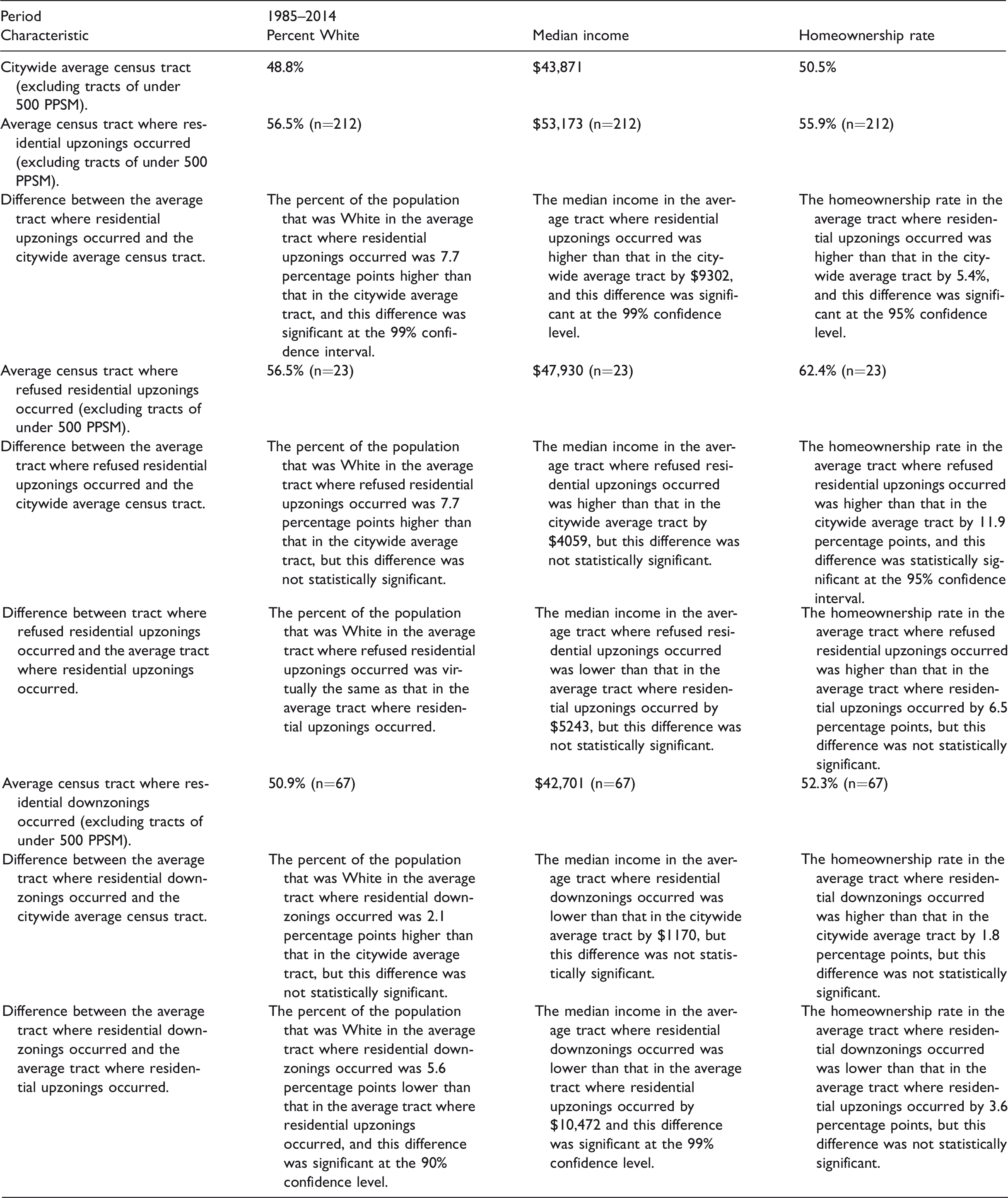
PPSM: persons per square mile.
Note: Figures for median income are shown in constant dollars.
The Durham context
Durham presents a good setting for a study of the role of race in exclusionary zoning practices because a large number of Durham’s residents have belonged to communities of color since the beginning of the period of investigation. The city has especially been a White and African-American city. In 1950, the Census counted 71,311 residents in Durham, identifying 63.4% of them as White, 36.6% of them as Negro, and virtually no one belonging to “Other” races (US Census, 1952). In 1980, there were 100,831 residents in Durham, 51.9% of whom were White and 47.1% of whom were Black (US Census, 1981). In 2010, 41% of Durham’s residents were White, 42.5% Black or African-American, 5.1% Asian and 14.2% Hispanic or Latino of any race (US Census, 2012). As these figures show, Durham has also consistently had a substantial proportion of White residents: Durham’s rapid annexation allowed a relatively consistent demographic profile throughout the seven decades since the Second World War. Thus, in contrast with more fragmented metropolitan areas, the core city of the Durham-Chapel Hill MSA has consistently included both racially segregated urban neighborhoods and the suburban, lower-density territories of exclusive White communities. Even today Durham still contains 46.6% of its metropolitan area’s population (US Census, 2015).
In the mid-20th-century, Durham’s African-Americans lived in nearly “complete isolation” from Durham’s Whites (Wilkinson, 1950: 2). Walltown and Lyon Park (see Figure 1) were two small African-American enclaves of the city’s West End that grew up on low-lying and uneven land abutting the streetcar lines that branched outward from the city’s industrial districts (Brown, 1985). Two other communities existed along rail lines in the city’s East End and in the Hickstown neighborhood in the city’s northwest corner.

A map showing neighborhoods and major geographical features of Central Durham, showing African-American neighborhoods of the mid-20th-century in hatching. A version of this map originally appeared in Whittemore (2017).
Most of the city’s African-Americans, however, lived in the quadrant of the city radiating to the southeast from downtown. The business and residential core of this area nearest to downtown, known as the Hayti, had expanded from an early post-Civil War community of freed slaves (Anderson, 2011). The concentration of so much of the African-American population in the Hayti and in adjacent areas to the southeast was the product of both white flight and intimidation of African-Americans seeking residence elsewhere in the city (Wilkinson, 1950). In 1960, the Hayti was the most crowded neighborhood in the city, with a population density of 10,343 PPSM. While this was not dense compared to many larger American cities, the great majority of Hayti’s population lived in single and two-family houses (City of Durham, 1960: 13). Contemporary planners and legislators saw the downtown-adjacent neighborhood as a slum, and freeway construction and urban renewal together removed the Hayti beginning in the late 1960s. A majority of landlords in the Hayti at the time demolition began were White, and in the words of one contemporary observer, engaged in a “profitable, though not lucrative, business venture” (Stukes, 1970: 11) by taking advantage of the growing and segregated African-American population.
Durham never had racial zoning, but its initial zoning scheme was clearly motivated by racial geography. Conventional wisdom at the time associated uniformly lower residential densities with social, environmental, and economic desirability, as evidenced in the contemporary Village of Euclid v. Ambler Realty Co decision’s description of an apartment building in an area of detached homes as a “parasite” (US Supreme Court, 1926: 394–395). According to the city’s, 1926 zoning map (Durham Zoning Commission), the five African-American ghettos were the only areas outside of the downtown-adjacent tenement districts placed within multi-family Residence Zone “C,” which allowed 27 units per acre. Every other residential neighborhood beyond downtown fell within the more exclusive “A” or “B” categories that allowed 9 and 18 units per acre, respectively. This is not because the ghettos contained only tenements, or even mostly consisted of tenements. Over 95% of Hayti’s housing units were still within one or two-family homes three decades later (City of Durham, 1960: 13), and Lyon Park contained many homes custom-built for the city’s African-American businessmen (Brown, 1985). These areas simply did not receive the favorable treatment of their White-occupied counterpart neighborhoods.
By some measures Durham was a relatively progressive city. For much of the 20th-century, downtown contained a number of African-American businesses concentrated in an area called “Black Wall Street.” Nevertheless, it is unlikely that African-American neighborhood concerns were well represented in city leadership until well after the Civil Rights movement: Council was not descriptively representative of African-Americans because there were few African-American councilmembers before the 1980s, and at least in regards to zoning decisions it is unlikely that the council was substantively representative of African-American concerns either (as I will discuss in the following section). In the 20th-century, Durham voters elected all of their councilmembers in citywide elections, and despite African-Americans composing a third of the city’s population and a quarter of the city’s voter registration in 1965 (Sarratt, 1969: 1), it had only elected one African-American to council by that time. Two African-Americans served on council from 1967 until 1976, then between two and four until 1984. Durham had at least five African-American councilmembers from then until the close of the century who constituted, along with allied White progressives, a dominant liberal coalition throughout the late 1980s and 1990s (Anderson, 2011). Durham elected its first African-American mayor in 1989, and elected an African-American majority to council for the first time in 1995. Durham reduced the number of seats on its council to six in 2001 and has had three African-Americans on council since then.
Exclusionary zoning in Durham, 1945–1984
Before 1985, residential downzonings and refused residential upzonings occurred in average census tracts that were Whiter than the citywide average tract (excluding census tracts of under 500 PPSM) by statistically significant margins. The average tract where residential upzonings occurred was also Whiter than the citywide average tract but not by a statistically significant margin. The percentages of residents who were White in the average tracts where residential downzonings and refused residential upzonings occurred were still larger than that in the average tract where residential upzonings occurred by statistically significant margins. While the homeownership rates in the average tracts where refused upzonings and residential downzonings occurred were significantly higher than the homeownership rate in the citywide average tract, they were statistically indistinguishable from the homeownership rate where residential upzonings occurred, suggesting that it is unlikely that the distribution of exclusionary practices is related to homeownership rates in this period. The median income in the average tract where refused residential upzonings occurred was statistically indistinguishable from that in the citywide average tract and, surprisingly, lower than that where residential upzonings occurred by a highly statistically significant margin. The median income in the average tract where downzonings occurred was statistically indistinguishable from the median income in the citywide average tract and from the median income in the average tract where residential upzonings occurred (see Table 1). Taken together, the quantitative evidence suggests that from 1945 through 1984, the areas that the city shielded from residential intensification were Whiter areas, but not higher-income areas or areas with higher homeownership rates than the areas where upzonings occurred. This suggests that race offers a more compelling explanation for exclusionary zoning before 1985 than either homeownership or income in Durham.
From an early date, petitions for downzoning in White areas targeted parcels zoned for apartments. One cited a desire to “improve living conditions” (DCCM Book T, 19 March 1945, p. 371), and the Planning and Zoning Commission recommended pursuing a similar downzoning to Council in the interest of “healthy growth” (DCCM Book X, 3 August 1953, p. 511). Similarly, opposition to proposed residential upzonings centered on the need for “proper protection” of single family homes from “individual interests” (DCCM Book DD, 6 January 1964, p. 139), fears of congestion and safety hazards for children (DCCM Book FF, 21 November 1966, p. 4), or overcrowding schools (DCCM Book DD, 20 January 1964, p. 149; DCCM Book GG, 21 January 1969, p. 473; DCCM Book MM, 21 October 1974, p. 62). More darkly, the arrival of apartments in predominantly single-family White neighborhoods may beckon trespassing “strangers” (DCCM Book JJ, 3 July 1972, p. 415), initiate an “erosive process” (DCCM Book EE, 18 October 1965, p. 168), or create such congestion and safety hazards that “there would be no rest for a single person in Durham, for fear that the same thing [upzoning for apartments in this case] would happen to them” (DCCM Book EE, 2 May 1966, p. 368).
On their face, these were statements related to social and property value concerns that had apparently little to do with race, though given their vagueness, it is also hard to assume that they were definitely not the product of racial prejudice. City Council certainly would have discouraged any explicit discussion of racial anxieties at the time: the US Supreme Court (1917) had long ago struck down the use of zoning for the purpose of racial segregation. It is also important to consider that the Commission could support a proposal to upzone for apartments in the African-American Hayti while admitting a problem of local school crowding (DCCM Book DD, 15 July 1963, p. 3). It could also frame a proposal to upzone for apartment construction in the Hayti as a matter of increasing property values (DCCM Book Y, 21 December 1953, p. 50): in this case, value accrued to the usually outside, White, investor. These inconsistencies in approaching similar cases in White and African-American areas suggest that the Commission and Council may have seen reasons for acting against greater densities beyond the stated arguments in White areas.
There are other examples of apparently incongruent zoning practices between White and African-American areas. Durham desegregated its public housing in 1964, and Whites thereafter refused to move into public housing units (Sarratt, 1969). By that time, the city had three times re-designated single-family zoned parcels in African-American areas for apartments to allow the construction of public housing (DCCM Book W, 18 February 1952, p. 604; DCCM Book Z, 19 November 1956, p. 575; DCCM Book DD, 20 April 1964, p. 253). The city had re-designated one duplex-zoned parcel in a White area for apartments to allow for public housing (DCCM Book W, 18 February 1952, p. 605). The concentration of public housing was thus already imbalanced, with 80% of units located in the city’s African-American southeast (Sarratt, 1969), and after desegregation in 1964 the Housing Authority found it very difficult to site public housing in White areas (Sarratt, 1969).
African-American housing activists were not against the construction of public housing (as it represented a better alternative to overcrowded rental stock), but saw its repeated construction in the city’s southeast furthering the creation of a “black ghetto” (Cross, 1968: 5), and expressed anger at defeated rezonings for public housing in White neighborhoods (Cross, 1968). The Planning and Zoning Commission defended the segregated geography of public housing, arguing that upzoning for public housing was only fit for the “renewal areas” outfitted with adequate services for low-income people (DCCM Book FF, 20 February 1967, p. 133): principal among these areas was the African-American Hayti, where the Housing Authority constructed its 20-acre Fayette Place project in 1967. This segregation was also desirable because it meant “established neighborhoods are not threatened” (DCCM Book FF, 20 February 1967, p. 133): judging by the characteristics of areas where rezonings had occurred to allow for public housing, “established neighborhoods” were White neighborhoods.
Meanwhile, in White neighborhoods of various class characteristics, opponents to upzonings and proponents of downzonings utilized language in hearings that, given Durham’s targeting of African-American neighborhoods with urban renewal and public housing, may well have indicated White fears of African-American encroachment: for example, in an average-income White area with only an 18% homeownership rate, the use of the term “blight” to describe the presence of apartments near single family homes (DCCM Book VV, 21 November 1983, p. 48), or in a high-income White area with an 86% homeownership rate the term “substandard housing” to refer to housing built at a relatively low density of five units per acre (DCCM Book VV, 4 June 1984, p. 443). Residents of a nearly exclusively White, average-income area of central Durham with a 72% homeownership rate successfully pressed for a downzoning referring to the “fragile” and “inner city” nature of their area (DCCM Book WW, 3 December 1984, p. 224) and pointing out that a housing project had once been proposed on the targeted parcels (p. 225).
Exceptionally, large downzonings ensued in White areas: in 1980, the city halved the density allowed on 25 acres in West Durham from 30 to 15 dwelling units per acre (DCCM Book SS, 3 November 1980, p. 398). In 1981, it downzoned 47 acres in North Durham from six to four dwelling units per acre (DCCM Book TT, 8 July 1981, p. 88), in 1983, 130 acres in Southwest Durham from six to two units per acre (DCCM Book VV, 21 November 1983, p. 50), and in 1984, 45 acres in South Durham from six to under four units per acre (DCCM Book VV, 19 June 1984, p. 494). The 130 acre downzoning followed a lengthy hearing during which development opponents in this majority-White area expressed anxiety over the types of construction and people associated with higher densities (DCCM Book VV, 21 November 1983, pp. 48–50).
All of this is not to say that exclusionary actions never occurred in African-American areas. While refused residential upzonings occurred within significantly Whiter than average areas before 1985, seventeen of these actions (out of 68) occurred within African-American majority census tracts. One cluster of refused residential upzonings occurred in an African-American neighborhood in the early 1960s when the City Council three times (DCCB Book BB, 3 October 1960, p. 460; DCCM Book CC, 3 June 1963, p. 575; DCCM Book DD, 21 October 1963, p. 71) rebuffed a landlord and builder widely criticized in the African-American community for rent-gouging, poor maintenance, and overcrowding tenants (Piercy, 1968; Sarratt, 1969). Whites unquestionably understood him as a builder and owner of housing for African-Americans: low-income Whites tended to move out of his properties as he ignored tenant needs, while low-income African-Americans, having fewer alternatives, moved in (Sarratt, 1969). Despite his poor reputation with civil rights activists and early defeats, he eventually achieved three upzonings for his apartment projects in African-American areas (DCCM Book DD, 15 February 1965, p. 519; DCCM Book JJ, 20 September 1971, p. 45 and 20 December 1971, p. 169) as Council rebuffed him three times in White areas (DCCM Book EE, 18 October 1965, p. 169, 6 December 1965, p. 213, and 18 July 1966, p. 482). His only successful request in a White majority census tract was in a newly annexed, sparsely populated area previously not zoned for urban use (DCCM Book JJ, 28 February 1971, p. 246).
Another cluster of refused residential upzonings in majority African-American census tracts (DCCM Book OO, 7 September 1976, p. 153; DCCM Book SS, 14 January 1980, p. 141 and 2 March 1980, p. 523; DCCM Book TT, 3 August 1981, p. 116; DCCM Book UU, 2 May 1983, p. 285) occurred within East Durham neighborhoods undergoing a gradual demographic transition away from a previous White majority. The particulars of some of these decisions reveal that they may well have been driven by White fears of further neighborhood turnover, while African-American residents also had anxieties about neighborhood change. One proposed rezoning would have made way for housing subsidized under the auspices of the Housing Authority (DCCM Book OO, 7 September 1976, pp. 152–153). At a nearby location seven years later there was a request for an upzoning to allow duplexes. At a hearing on the upzoning, two opponents, both likely to be White (Ancestry.com, 2011, 2012, 2015), argued that duplexes’ renters would bring crime, while another opponent, likely to be African-American (Ancestry.com, 2007, 2010), claimed duplexes would “destroy the appearance of the neighborhood.” Yet another opponent, whose race is unclear, claimed the allowed housing would resemble a nearby public housing project (DCCM Book UU, 2 May 1983, pp. 284–285).
Thus while exclusionary actions occurred in both White and African-American areas prior to 1985, they were far more common in White areas, where they were grounded in fears of developers and housing types associated with African-Americans, or in euphemistically described, imagined outcomes of more inclusionary scenarios. Within African-American areas, those few exclusionary actions that did occur were grounded in realities of crime, slumlords, and the unfair distribution of public housing.
Exclusionary zoning 1985–2014
From 1985 through 2014, refused residential upzonings occurred in an average tract with a percentage of Whites that was statistically indistinguishable from that in the citywide average tract and the average tract where residential upzonings occurred; residential downzonings occurred in an average tract with a percentage of Whites that was statistically indistinguishable from that in the citywide average tract, but slightly and significantly lower than that in the average tract where residential upzonings occurred (see Table 2). This stands in contrast to the years from 1945 through 1984, when residential downzonings and refused residential upzonings happened in average tracts that were significantly Whiter than the citywide average tract and the average tract where residential upzonings occurred (see Table 1). The average tract where residential downzonings occurred since 1985 also had a lower median income than the average tract where residential upzonings occurred by a statistically significant margin. The homeownership rate in the average tract where refused residential upzonings occurred was significantly higher than that in the citywide average tract, but not significantly higher than that in the average tract where upzonings occurred (see Table 2). Two different trends may explain these observed shifts: White homeowners’ advocacy of downzonings in lower-income core areas of the city for the purpose of neighborhood conservation, and the city’s efforts to reduce the concentration and expansion of lower-income housing in core areas in favor of its integration across the city.
The latter trend was in part due to the city’s newfound enthusiasm in the mid-1980s for protecting Durham’s African-American neighborhoods from industrial, commercial, and residential developments that caused health hazards and other disamenities for residents. The growing representation of African-Americans on City Council from the mid-1980s likely encouraged this, but significant energy for changing the treatment of African-American neighborhoods derived specifically from a 1983 chemical spill at an East Durham chemical plant (Andrews et al., 1985; DCCM Book WW, 4 February 1985, pp. 353–358). Many downzonings following this tragedy involved rezoning from heavy commercial or industrial use for less intensive uses (Whittemore, 2017). But the city also initiated residential downzonings in African-American neighborhoods, especially in areas previously zoned for apartment construction, with residents supportive of the decisions often citing issues with crime (DCCM Book XX 4 November 1985, p. 363; DCCM Book YY, 23 February 1987, p. 548; DCCM Book ZZ, 2 November 1987, p. 538). From 1975 through 1984, residential downzonings (n = 19) occurred in an average tract that was 74.4% White, significantly higher than the 52.6% of residents who were White citywide at the 1980 census (excluding census tracts of under 500 PPSM), and significantly higher than the 56.6% of residents who were White in the average tract where upzonings occurred in that period. Downzonings happening in the next decade (n = 41) occurred in an average tract that was 52% White, insignificantly less than the 53.2% of residents who were White citywide at the 1980 census (excluding census tracts of under 500 PPSM), and insignificantly less than the 53.9% of residents who were White in the average tract where upzonings occurred in that period.
Contemporary planning documents (Durham City-County Planning Department, 1991) likewise pointed out the over-concentration of low-income housing in African-American majority areas and issues with crime. Partnerships between the city and community groups also produced documents citing the capacity of zoning reform to improve the quality of life in African-American neighborhoods (see for example Northeast Central Durham Partners Against Crime Advisory Group, 1994). Occasionally, however, residents of African-American neighborhoods (who were increasingly homeowners) used language similar to that more common in White areas: that apartments did not belong in neighborhoods that were characteristically single-family (DCCM Book XX, 16 December 1985, p. 417), or that proposed single-family homes were undesirable on the basis of their being “smaller” than others in the area (DCCM, 2 August 1993, p. 24). Development opponents were successful in both of these cases (DCCM Book XX, 16 December 1985, p. 418; DCCM, 18 October 1993, p. 26). Still other efforts to downzone areas of southeastern Durham, even where residents were citing crime and a lack of amenities to support new residents, were ultimately rejected by the City Council (DCCM, 20 September 1993, p. 34 and 21 February 1994, pp. 19–21). Likewise, at least one upzoning for apartment construction in an African-American area of East Durham went forward even as residents protested over the possibility of congestion and associated hazards to children (DCCM Book BBB, 21 November 1988, pp. 154–156).
Concurrent downzonings in White central Durham neighborhoods seem to have been less concerned with discouraging disamenities as with enhancing the desirable qualities of these neighborhoods. One residential downzoning occurred in the White neighborhood of Duke Park for the stated purposes of maintaining “community character” and “tradition” (DCCM Book WW, 1 April 1985, p. 503). More occurred in other central White neighborhoods including Morehead Hill (DCCM Book ZZ, 27 July 1987, pp. 308–313), Watts-Hillandale, where the city downzoned over a hundred acres (DCCM 20 April 1992, pp. 51–52), and Trinity Heights, where the city downzoned over 32 acres (DCCM 19 August 1991, p. 41 and 4 May 1992, p. 16). These neighborhoods, all relatively central in their location, were at the time undergoing revitalization: incoming homebuyers there were intent on restoring the aging housing stock, and argued against the traditional tactic of using lenient zoning to attract reinvestment (DCCM Book ZZ, 27 July 1987, pp. 308–309). In particular, residents of these neighborhoods pushed for the city to target areas zoned for “General Residential,” a category that allowed up to four families per lot. They argued that it allowed property owners to convert single-family homes into rooming houses. Contemporary planning accommodated these desires and the above mentioned rezonings in Watts-Hillandale and Trinity Heights removed two-thirds of all “General Residential” zoning that had existed in the city’s Northwest Central community plan area (Durham City-County Planning Department, 1990).
Conventional concerns over schools and congestion continued to drive residential downzonings and refused residential upzonings in suburban White portions of the city. Occasionally neighbors also voiced concerns that upzonings would bring lower-priced units (DCCM Book XX, 4 November 1985, p. 360), or bring residents who would not care for their properties (DCCM Book WW, 4 February 1985, pp. 379–381). Despite statements among councilmembers that inclusion was a priority in Durham neighborhoods (DCCM Book AAA, 15 February 1984, p. 184), the number of residential downzonings grew in the decade from 1985 through 1994. Nothing seems to have irked residents of suburban White neighborhoods since the mid-1980s as much as Planned Density Residential (PDR) development. PDR zoning establishes an over-arching maximum density for an entire development, but does not set lot minimum or setback standards. This effectively allows developers to cluster the permitted density into more compact forms such as groups of townhomes and preserve the remaining area for open space and private amenities. Suburban Durham homeowners tended not to see beyond the fact that PDR did not mandate single-family detached homes, and condemned requests for PDR because it allowed attached or multi-family units (DCCM Book XX, 5 August 1985, p. 196 and 4 November 1985, pp. 360–363; DCCM Book AAA, 4 January 1988, pp. 85–87), even when it did so at overall site densities comparable to those permitted under the existing zoning (DCCM Book YY, 4 December 1986, p. 436, and 16 March 1987, pp. 584–585).
By the late 1990s, however, the conventional concerns of suburban White homeowners seemed increasingly to go unheeded in Council. In a White area in northwest Durham, an upzoning for multifamily construction went ahead even as neighbors suggested that the development entailed a “loss of privacy” and was a “detriment to public safety” (DCCM 16 October 1995, pp. 18–19). In South Durham, another homeowner complained in vain that he had purchased his home having “assumed single-family homes would be constructed” in the area (DCCM 17 February 1997, p. 29). Conventional concerns over traffic impacts also failed to dissuade Council from approving suburban upzonings (DCCM 6 October 1997, pp. 17–20, 18 May 1998, pp. 8–10, 20 July 1998, p. 18), as did concerns over school crowding (DCCM 21 April 2003, p. 27). From 1995 through 2004, even as opposition to new development continued unabated in this high-growth period, the number of residential downzonings considered within this study shrank to seventeen (from 41 the previous decade) and the number of refused residential upzonings dwindled to seven (from 13). This trend has only continued since, suggesting the city’s stated policy of diversifying housing types across more neighborhoods may have taken hold.
Conclusion
Scholars have had difficulty assessing the motivations for exclusionary zoning practices. I have attempted to understand the distribution of and motivations for exclusionary practices by considering the racial, income, and homeownership characteristics of the areas where different types of residential rezonings occurred in Durham since 1945, and then corroborating my findings with qualitative evidence. I found that before 1985, residential downzonings and refused residential upzonings occurred in average census tracts that were Whiter than the citywide average tract and the average tract where residential upzonings occurred by statistically significant margins. This disparity was likely not driven by the property interests of middle to upper income homeowners: for the most part, median incomes and homeownership rates in the average tracts where residential downzonings and refused residential upzonings occurred were statistically indistinguishable from the average median incomes and homeownership rates in the citywide average tract and the average tract where residential upzonings occurred. This suggests that race offers a more compelling explanation for exclusionary decisions in this period than class-based interests.
In addition to this quantitative evidence, the records of public hearings reveal inconsistencies in the handling of similar zoning cases in White and African-American areas, especially in regards to public housing projects and exploitative developers. These projects and developers, because they both overwhelmingly served African-American residents, were no doubt associated with African-Americans and therefore kept out of White areas. It is also important to consider that even as residents of both White and African-American areas voiced concerns ostensibly related to the social and economic value of their neighborhoods, African-Americans seemed to go ignored more often, suggesting that Council implicitly perceived additional reasons to listen to Whites. And it is important to consider that Whites in neighborhoods of various incomes and homeownership rates used an abundance of euphemistic language when describing imagined outcomes of more inclusionary scenarios: language that successfully resulted in exclusionary actions. In sum, before 1985, the quantitative and qualitative evidence demonstrate inconsistencies in zoning practices to be apparent across racial boundaries, but not as apparent across areas of different incomes or homeownership rates. I thus have argued that racial bias was a prominent motivation for exclusionary actions before the mid-1980s in Durham.
From 1985 through 2014, refused residential upzonings occurred in an average census tract with a percentage of Whites that was statistically indistinguishable from that in the citywide average tract and the average tract where residential upzonings occurred. The percentage of residents who were White and the median income in the average tract where residential downzonings occurred were significantly lower than the percentage of Whites and the median income in the average tract where residential upzonings occurred. This is likely due to a push to limit the expansion of lower-income housing in areas that already had a lot of it: this was an official policy of the city but also, in some cases, a preferred tactic of White homeowners interested in the physical and social conservation of traditionally White inner-city neighborhoods. Thus at the same time that the city continued approving exclusionary actions in White neighborhoods, the city also increasingly targeted African-American neighborhoods with downzonings intended to impede the further concentration of low-income housing there. Since the mid-1990s, exclusionary zoning decisions have declined in the city altogether. This is likely due to an explicit planning strategy aimed at creating more affordable housing options across the city. The fact that the policy of de-concentrating lower-income housing only developed at a time of increased African-American political representation gives further credence to the idea that the earlier disparate treatment of White and African-American neighborhoods was due in large part to race.
This paper has argued that historically, the areas of Durham that successfully pursued exclusionary zoning may be best described as Whiter ones, and that Whites pursued this treatment at least out of implicit fears of African-American neighbors. Only with African-American political empowerment and greater attention to the needs of African-American communities did the disparity in the distribution of exclusionary decisions become less apparent (and to some extent reverse, due both to core neighborhood revitalization and a policy of housing integration). Thus nearly throughout the 20th-century, zoning continued to play a role in the preservation of Whites’ social and economic privilege at the expense of people of color, and it was through gradual African-American empowerment that this was challenged. Indeed, while the Durham-Chapel Hill metropolitan area did not see the postwar spate of suburban incorporation that other American cities experienced, these exclusionary practices may continue in communities outside of Durham’s city limits where African-Americans lack substantial representation. Given that African-American empowerment has not been universal across American localities, and in light of recent developments including Inclusive Communities (2015) and HUD’s (2015) “Affirmatively Furthering Fair Housing” rule, it is imperative that scholars continue to investigate the disparate impacts of zoning and other public policies on communities of different demographic characteristics.
Footnotes
Declaration of conflicting interests
The author(s) declared no potential conflicts of interest with respect to the research, authorship, and/or publication of this article.
Funding
The author(s) received no financial support for the research, authorship, and/or publication of this article.