



Abstract
Abstract
This study aims at visualizing the spatial distribution of road network per person in the city of Istanbul, Turkey. As a world city, Istanbul connects two continents and has almost 15 million population. Therefore, the city has a tremendous road network consists of 713,634 edges and 242,545 nodes. The road network is mapped on an equal population distribution cartogram for displaying where the least and the most amount of roads per person exist. These feature graphs might help planners, geographers, decision makers etc. for improving their understandings regarding the network topology of the road network.
These feature graphics are based on road network maps of the city of Istanbul, Turkey. They were created using geographic information systems and network analysis. The road data were downloaded from Open Street Maps (OSM), and the neighbourhood boundaries and neighbourhood population data are for the year 2017. ArcGIS 10.5 was used to generate the urban road network topology. Street network topologies have recently been generated by Swords and Carlisle (2017) with ‘lack of geospatial references’ and theorized by Barabási and Stanley (1995), Barthelemy (2011) and Karduni et al. (2016). The geospatially referenced street topology on an unequal population cartogram (Dorling, 2012) can give insights into the topology and morphology differences of populous cities like Istanbul. This study aims to display the unequal distribution of road networks across the neighbourhoods of Istanbul. Two greyscale feature graphics are presented which display where there are the fewest roads per person across the neighbourhoods.
Istanbul is truly a world city (Friedmann, 1995; Knox and Taylor, 1995; Sassen, 2018) and has almost 15 million inhabitants (World Population Review, 2018), making it the 14th most populous city in the world. The sum of the length of all roads regardless of their type and width is 32,062 km. These roads connect two continents by three bridges and a tunnel under the sea (Figure 1). There are 984 neighbourhoods in İstanbul. The most populous contains 85,652 people and is located in Europe; the least populous contains 105 people and is located in Asia. Thus, as expected, the distribution of the road network is quite unequal across the city (Figure 1).
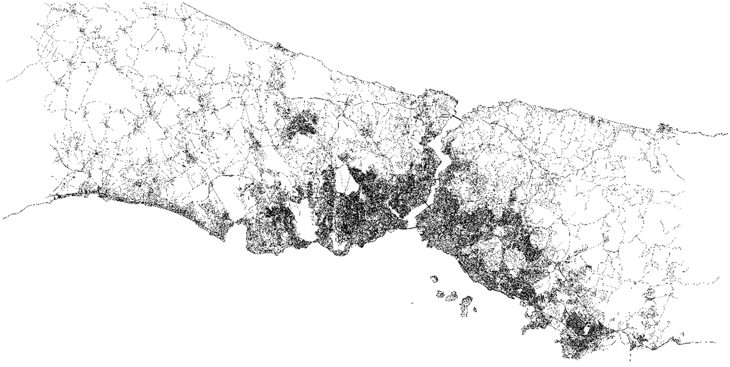
Nodes and edges in the road network of the city of Istanbul.
The OSM is a well-known online source of road data frequently used in studies dealing with transportation research, urban planning studies and space syntax, among other subjects (Haklay and Weber, 2008). The road network topology of İstanbul has 242,545 nodes and 713,634 edges (Figure 1). Edges refers to the road segments, and nodes refers to the junction points. The increasing density of the darker shading in Figure 1 shows the growing number of roads and junction points (congestion). It is clear that the map becomes darker moving from the periphery towards the historical core of the city, and white areas are located at the periphery. At this point, assessing the distribution of roads per person across the city can be quite informative. In order to do this, the spatial distribution of road segments and the junction points on an equal population cartogram of neighbourhoods of İstanbul city is mapped (Figure 2). The distortion and size error according to the population density of the city and the road network is displayed in Figure 2, and also for the historical core of the city in Figure 3. It is clear on the cartogram that the areas that are dense and black (neighbourhoods close to the historical core and Bosporus) in Figure 1 turn into white areas in Figure 2 (in the middle of the map) as these areas have higher populations and fewer roads per person.

The cartogram road network map of the city of Istanbul.
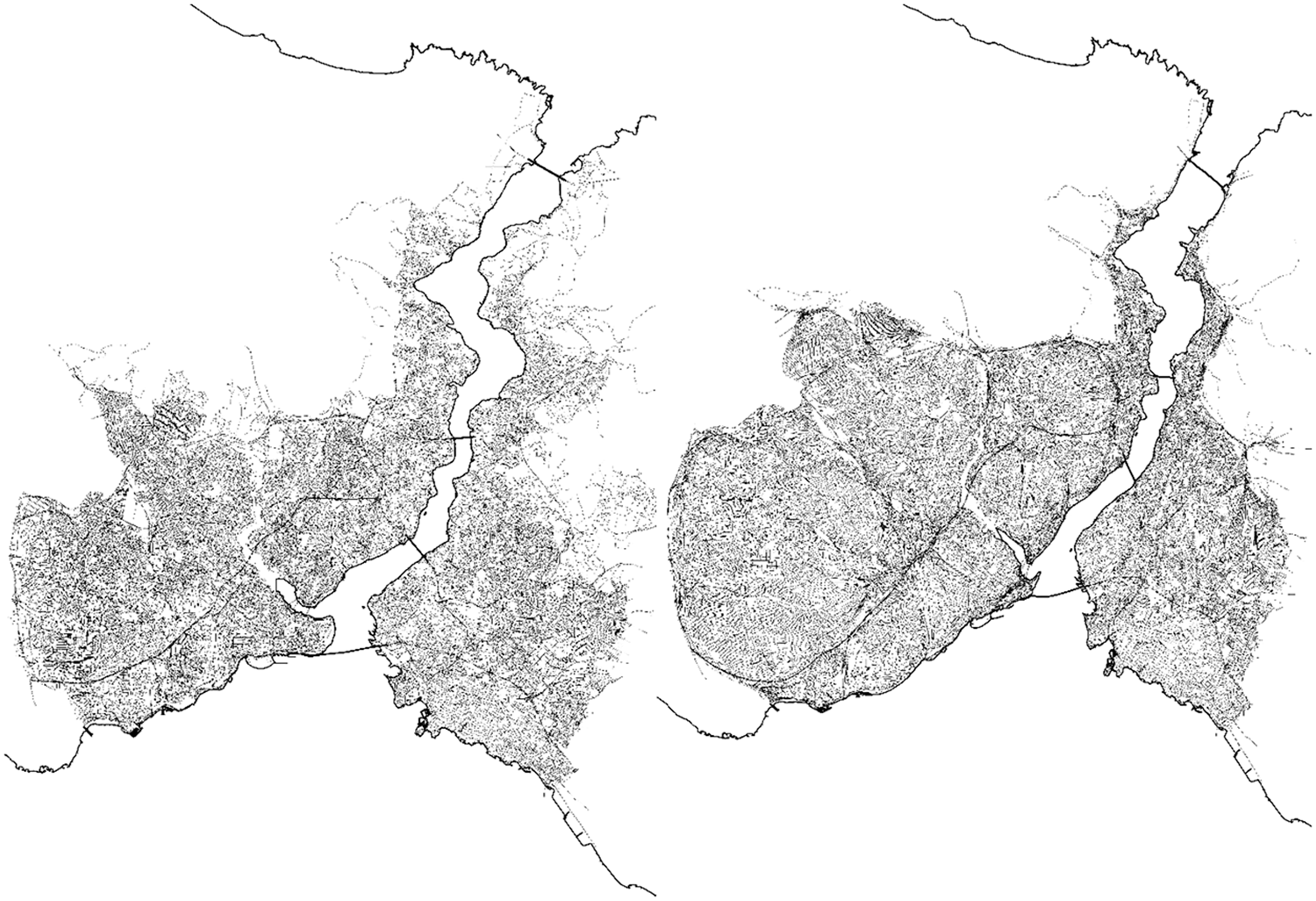
Nodes and edges in the road network and the cartogram road network map of the historical core of Istanbul city.
Geographers, planners and others may utilize the road network-based city topologies to increase understanding of urban environments and to assess the equity in distribution of urban amenities and services, including roads, subway lines, infrastructure, communication lines and trade routes.
Footnotes
Declaration of conflicting interests
The author(s) declared no potential conflicts of interest with respect to the research, authorship and/or publication of this article.
Funding
The author(s) received no financial support for the research, authorship and/or publication of this article.