
Abstract
Alluvial fans and fluvial terraces occur in nearly all climatic settings and often coexist within the same drainage basin. These landforms play an important role in understanding the geomorphic, hydrologic, sedimentologic and erosional histories of a basin. The juxtaposition of fans and fluvial terraces, in some instances, can lead to misinterpretation in distinguishing traditional fluvial terraces from the truncated toe of tributary alluvial fans. This becomes particularly troublesome for those attempting to interpret results from published field studies where fan-cut terrace, truncated alluvial fan, toe-cut alluvial fan, alluvial terrace, and incision of the lower end of a fan piedmont all refer to the same genetic landform. We call for use of the term “toe-cut terrace” to represent this landform. We also present criteria to aid in the identification of toe-cut terraces, defined as an abandoned alluvial surface, formed by the truncation of the distal portion of tributary alluvial fans by streams flowing obliquely or perpendicular to the fan surface. Truncation occurs through lateral erosion (“toe-cutting”) or through vertical incision by the trunk drainage lowering the base-level of the alluvial fan. This results in incision into the fan surface abandoning the fan’s depositional surface at a higher level above the modern floodplain – a form that often resembles a fluvial terrace. A case study from the Sonoran Desert in central Arizona illustrates a sequence of abandoned alluvial surfaces that resemble fluvial terraces, but use of the proposed criteria reveal the presence of both toe-cut terraces and traditional fluvial terraces formed by the abandonment of the rivers former floodplain.
I Introduction
Toe-cut terraces (Figure 1) form as a result of the interaction between a basin’s trunk stream and alluvial fans that originate from tributary drainages. They often form when a drainage basin’s trunk stream laterally migrates and erodes the distal portion of an alluvial fan. This process is referred to as “toe-cutting” (Figure 2; Leeder and Mack, 2001). The resulting landscape reflection of this process is the abandonment of the alluvial fan surface above the modern floodplain (Figure 3). Toe-cut terraces can also develop when vertical incision of the trunk stream lowers the local base-level of the tributary fan flowing into it, thus abandoning the former alluvial fan surface at a higher level (e.g. Figure 4; Colombo, 2005; Colombo et al., 2000). These two mechanisms are the focus of toe-cut terrace formation as they are modern processes acting at the surface. It is possible that exhumed toe-cut terraces may be present when deep vertical incision exposes formerly buried fan deposits and truncates them. However, the focus of this manuscript is on processes and deposits interacting at the Earth’s surface. Toe-cut terraces are important features because of their broader implications for stratigraphic basin analysis, groundwater studies (Leeder and Mack, 2001) and landscape evolution, especially in arid environments (Larson, 2013).

Idealized oblique-angle diagram of morphologic relationship between a fluvial terrace, a toe-cut terrace, and a modern floodplain. While the fluvial terrace scarp remains parallel to the trunk drainage, the toe-cut terrace scarp bounds both the tributary and the edge of the fan, which has been truncated by the trunk drainage. Viewed from the channel, an alluvial toe-cut scarp appears to parallel the trunk stream and can look very much like a traditional fluvial terrace.

Toe-cutting of tributary alluvial fans along the Minnesota River Valley, Minnesota, USA. This LiDAR digital elevation model shows that lateral migration of the Minnesota River Valley has eroded the distal portion of some alluvial fans—a process noted in the literature as “toe-cutting.” Other intact fans will experience a similar erosional fate.
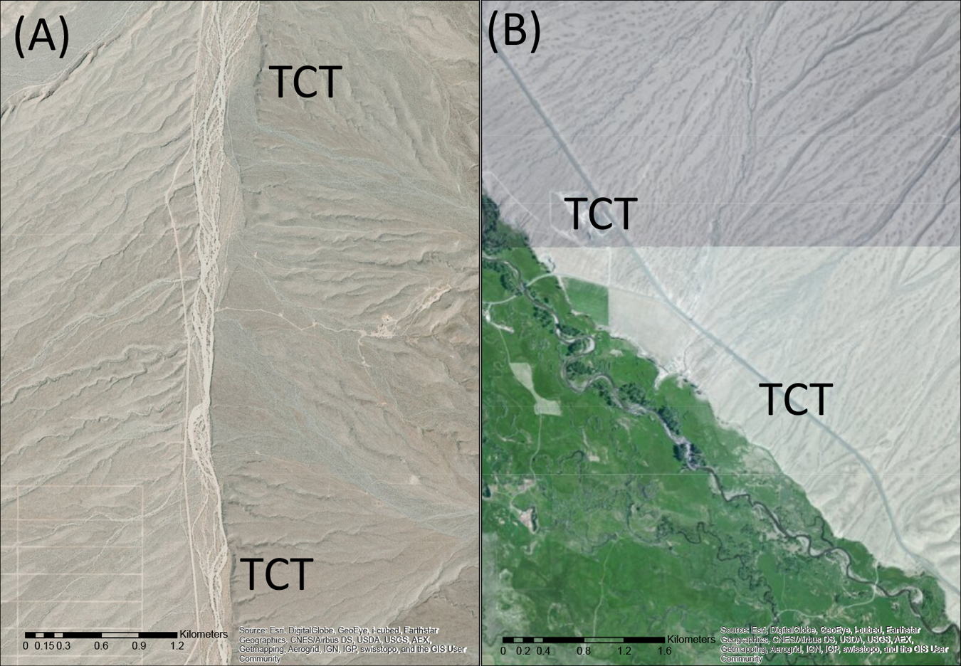
Examples of toe-cut terraces in the western United States. The image on the left (A) shows toe-cut terraces (TCT) along White Elephant Wash, northern Arizona, USA. In this image an older alluvial fan has been truncated by the wash, resulting in the formation of TCTs. At a lower level, more recent alluvial fans are being truncated as well by both vertical and lateral incision processes of the wash, evidenced by both vertical escarpments and curved erosional scars cut out of the fans. The image on the right (B) shows the classic toe-cut alluvial fan location of Old Lost River, Idaho, USA, discussed in Leeder and Mack (2001). Note the curved erosional scars cut out of the distal end of the alluvial fans at this site. Lateral migration of the Old Lost River has eroded the distal portion of these fans leaving behind a higher alluvial surface, a toe-cut terrace (TCT).
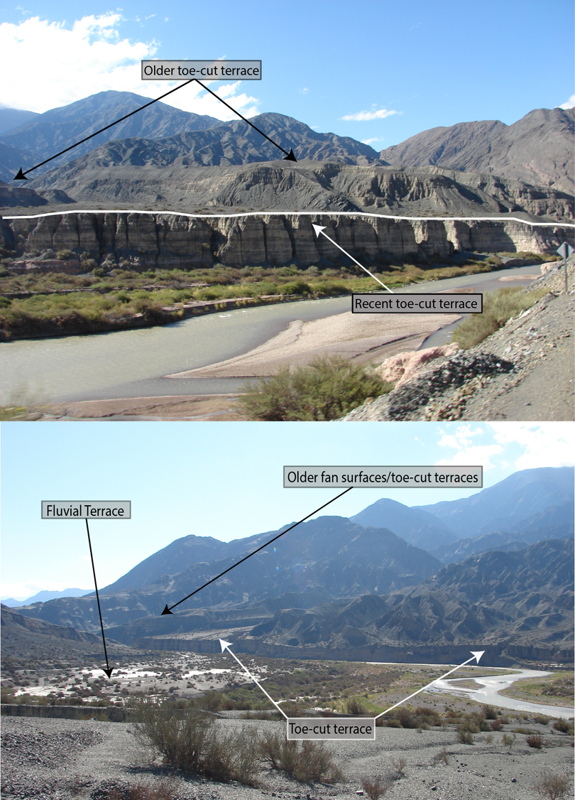
The Rio San Juan Valley, Argentina, exhibits classic examples of the truncation of alluvial fans, creating toe-cut terraces through the process of trunk stream incision lowering the base-level of the tributary fans (Colombo et al., 2000). (Top) Two separate incision events by the Rio San Juan formed two distinct toe-cut terraces, with the younger one (white line) inset an older toe-cut terrace (black arrows). (Bottom) A broader view where toe-cut terraces appear to form a laterally continuous riser that looks strikingly similar to a traditional fluvial terrace. In reality, these are coalescing fans (a bajada) now truncated by the Rio San Juan (Colombo et al., 2000). Photos by Phillip Larson.
Toe-cut terraces occur in many geomorphic settings (e.g. Figures 2 and 3), leading to study of them across the globe. For example, toe-cut terraces have been investigated in the Andes (Colombo, 2005; Colombo et al., 2000), in Death Valley (Blair and McPherson, 2009), along the Big Lost River Basin of Idaho (Leeder and Mack, 2001), along numerous rivers in northern India (Bedi, 1980; Chatterjee and Sarkar, 1982; Chopra, 1990; Jana and Dutta, 1996; Kesari, 2011; Kumar and Aravindan, 2007; Uniyal et al., 2010), in the UAE and Oman (Al-Farraj and Harvey, 2005), and in New Zealand (Carryer, 1966; Cox et al., 2014). Within the Basin and Range of western North America they exist as a prominent landscape feature in many basins (Gile et al., 1981; Pederson, 1981). For example, Pederson’s (1981) classification of landforms for soil scientists includes alluvial fans whose distal portions have been truncated by a basin’s trunk drainage. Indeed, these “toe-cut terraces” are genetically distinct landforms from other fluvial terraces in the same drainage basin (Figure 5) and being able to distinguish these different types of terraces significantly aids understanding of a basin’s evolution. The complication involving differentiation between toe-cut terraces and other fluvial terraces occurs when truncation/erosion of the lower end of the alluvial fan mimics the appearance of an abandoned former floodplain of the basin’s trunk drainage (e.g. Figure 4).
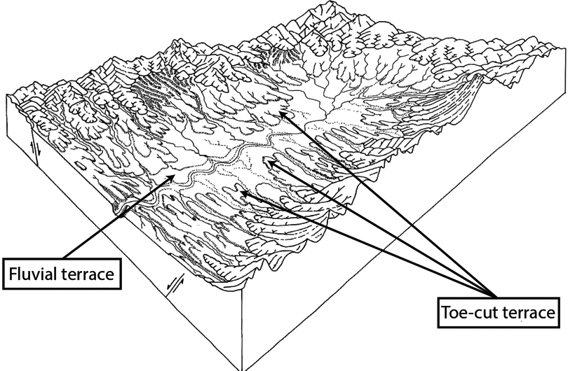
Pederson (1981: 35) sketched several “cycles” of dissection and deposition in a typical basin within the Basin and Range, North America. This adaptation of Pederson’s original diagram emphasizes the distinction between small isolated traditional fluvial terraces and the more dominant alluvial fans that have been truncated by an incising main wash. The truncation of alluvial fans results in toe-cut terrace formation.
Within geomorphic scholarship a number of terms have been applied to describe broadly this landform. The term fan-cut terrace is predominantly used in research conducted in India (Bedi, 1980; Chatterjee and Sarkar, 1982; Chopra, 1990; Jana and Dutta, 1996; Kesari, 2011; Kumar and Aravindan, 2007; Uniyal et al., 2010). In addition, we found: “toe-cut alluvial fans” (Blair and McPherson, 2009; Florsheim, 2004; Harvey, 2010; Leeder and Mack, 2001; Mack and Leeder, 1999; Mack et al., 2008; Suresh et al., 2007), “toe-trimmed alluvial fans” (Al-Farraj and Harvey, 2005), “truncated alluvial fan” (Manville, 2010; Sanchez-Nunez et al., 2012; Young et al., 1986), the “eroded distal end of alluvial piedmonts” (Pederson, 1981), and “alluvial terraces” (Colombo, 2005; Colombo et al., 2000; Gao et al., 2005). No single accepted term, however, exists for this basic landform (Figures 1 and 4). We suggest that “toe-cut terrace” serves as an appropriate term as it clearly defines the processes that create the form and differentiates the form from other fluvial terraces in a drainage basin. We define the toe-cut terrace as follows: an alluvial surface, abandoned above the local base-level, that forms through truncation of tributary alluvial fans by a stream flowing obliquely or perpendicular to the alluvial fan surface.
The lack of a commonly accepted term leads to potentially confusing wording in published research. For example, in the study by Colombo et al. (2000) on the Rio San Juan of Argentina, flights of abandoned alluvial benches sit as markers of the geomorphic landscape evolution of this area. In the San Juan Valley, cycles of alluvial fan sedimentation at the mouths of tributary streams result in fans that periodically dam the Rio San Juan. The river eventually overtops and incises into these fans, truncating them and lowering the tributaries’ base-level (Figure 4; Colombo, 2005; Colombo et al., 2000). This stream incision ultimately lowers the base-level of the tributary alluvial fans. The authors collectively refer to “alluvial terraces” to describe the treads above the Rio San Juan—some of which are clearly toe-cut terraces based on our definition. Although correctly identifying the alluvial sedimentology, we suggest the term “alluvial terrace” is far too ambiguous in describing the genetic origin because they are distinctly different from other San Juan fluvial terraces nearby.
The confusion over terms can result in more serious issues where this process produces a landform that looks very much like a stream’s former floodplain, but is a truncated alluvial fan. For example, the lack of an accepted terminology and criteria for distinguishing toe-cut terraces could have contributed to a basic misinterpretation of landforms above the Mojave River at Afton Canyon, California, USA. Meek (1989) proposed that Afton Canyon underwent a rapid incision as a result of basin overflow of Pleistocene Lake Manix. In contrast, others (Enzel et al., 2003; Wells and Enzel, 1994) identified features inside Afton Canyon as Mojave River fluvial terraces, suggesting periods of stabilization, floodplain formation and episodic down cutting.
These features along Afton Canyon are actually toe-cut terraces that simply represent truncation of the distal portions of alluvial fans by the incising Mojave River. However, the existence of these supposed fluvial terraces was then used as evidence that Afton Canyon did not undergo a rapid incision (Enzel, 2003). Despite the misidentification, Meek rejected this view and argued that the surfaces identified in Afton Canyon are all below the level of the lake basin floor and hence have no relevance on how fast Lake Mojave drained (Meek, 2004). Meek’s interpretation of the various surfaces inside Afton Canyon was later verified (Reheis and Redwine, 2008). Similarly, another misidentification of toe-cut terraces as wave-cut recessional terraces (Wells and Enzel, 1994) also occurred. Later research (Reheis et al., 2007: 20) clarified this issue and explained that the “scarps are not at a constant elevation, making another suggested interpretation of the scarps as wave-cut features unlikely.”
The confusion over terminology, the ease of incorrectly identifying toe-cut terraces, and the importance of understanding the complexities of a drainage basin’s history all highlight the need for a retrospective analysis of this basic landform. To address these issues, we first review the literature on toe-cut and traditional fluvial terraces and then present criteria that can aid in distinguishing toe-cut terraces from traditional fluvial terraces. Finally, we use the proposed criteria in a case study from a non-controversial drainage in central Arizona. Within this drainage basin the basic landforms look, at first glance, very much like fluvial terraces but include both toe-cut and traditional terrace forms.
II The terrace form
1 Fluvial terraces
Given that toe-cut terraces can be confused with other fluvial terraces in the same drainage basin, any literature review must start with a brief examination of the fluvial terrace form overall. This section does not encompass the whole of the fluvial terrace literature, but attempts to summarize contemporary understanding of the landform and its variety of genetic origins.
The history of fluvial terrace literature spans approximately two centuries, with Playfair (1802: 528) being the first to recognize their importance (Miller, 1883). The modern framework of fluvial terraces, however, largely stems from the fundamental works of GK Gilbert and WM Davis (Davis, 1902; Gilbert, 1877; Pazzaglia, 2013). A fluvial terrace represents the former floodplain, or surface of flow, of a river that was abandoned when the river incised to a lower level (Bull, 1990; Charlton, 2008; Harden, 2004; Hugget, 2003; Leopold et al., 1964; Petts and Foster, 1985; Ritter et al., 2002; Schumm, 1977). The surface of the former floodplain is known as the terrace tread, while the slope that rises to the tread is generally referred to as the terrace scarp, berm, or riser (Campbell, 1929; Ritter et al., 2002). Fluvial terraces are mapped or correlated as either paired or unpaired terraces. Paired terraces match elevation and theoretically have the same geochronologic significance on both sides of the river valley (Leopold et al., 1964; Ritter et al., 2002; Schumm, 1977). Paired terraces occur when vertical stream incision is greater than lateral migration of the stream channel (Schumm, 1977). These terraces can record a single incision event or multiple events that lead to uniform incision and terrace formation. Unpaired terraces do not match in elevation on either side of the river. Instead, they often have a staggered topography from valley side to valley side and likely form when lateral migration coincides with some degree of vertical incision (Charlton, 2008; Leopold et al., 1964; Schumm, 1977). It is also possible to have unpaired terraces as the result of the erosive lateral migration of the river, obliterating remnant surfaces, very similar to the “toe-cutting” processes altering the distal ends of alluvial fans (Leeder and Mack, 2001).
Geomorphologists classify terraces as depositional or erosional (Figure 6). The most common depositional terraces are fill terraces: they require an aggradational event within the stream valley, a period of floodplain formation, and subsequent incision of the stream channel abandoning that floodplain (cf. Ritter et al., 2002). Another form of a depositional terrace is a nested-fill terrace, where a river experiences an aggradational episode followed by incision. Another wave of aggradation ensues and that surface is abandoned, but to a lower level than the initial fill terrace (Easterbrook, 1999; Junior et al., 2011; Waitt, 1979).

Fluvial terraces can exist as both depositional and erosional landforms. This figure shows the four common fluvial terraces forms: (A) strath terrace, (C) fill terrace, (B) fill-cut terrace, and (D) cut and fill, or nested-fill, terrace. The fill terrace and nested-fill terrace are depositional forms while the strath and fill-cut terraces are erosional forms. Modified from Hargitai and Larson, in press.
Erosional terraces include strath (Bucher, 1932) and fill-cut terraces (Figure 6). Bull (1990) suggests that beveling of bedrock straths and strath terraces are the “fundamental tectonic stream-terrace landform;” they are often found where streams have tectonically induced downcutting. However, more recent research suggests strath terraces form through lateral planation of weakened or highly erodible banks (e.g. Larson and Dorn, 2014; Montgomery, 2004; Wohl, 2008), which leaves behind a thin veneer of alluvium overlying the now-beveled bedrock surface. Formation of this erosional landform is followed by channel incision, resulting in a strath terrace (Figure 6A) (Mackin, 1937). Fill-cut terraces are similar (Figure 6B) although they do not bevel a bedrock “strath.” In the genesis of fill-cut terraces, a stream valley has filled with alluvium and the alluvium is laterally eroded by the stream to form an erosional surface, which is then followed by incision into this floodplain. It is important to note that the highest terrace in a valley filled with alluvium is likely a fill terrace and is depositional in origin. Fill-cut terraces are inset within a fill terrace and represent further incision events within a stream valley.
2 Incision mechanisms
Incision mechanisms resulting in the fluvial terrace form—as well as subsequent incision of tributary alluvial fans—can result from changes in intrinsic or extrinsic variables in the fluvial system, ultimately influencing the balance between sediment discharge (Qs) and stream fluid discharge (Q). According to the paradigm of grade (Bull, 1990; Davis, 1902; Gilbert, 1877; Mackin, 1948; Schumm, 1977), streams tend toward a state of equilibrium (or grade) in which Q is sufficient to transport all of Qs (Baker and Ritter, 1975; Bull, 1979; Mackin, 1948; Schumm, 1977). The longitudinal profile of a graded stream is often assumed to have a concave-up form, which is taken to be a function of how the Q/Qs relationship changes in the downstream direction (Gilbert, 1877) (i.e. discharge typically increases and bed load grain size typically decreases downstream). For grade to establish, base-level must remain stationary (Bull, 1991; Gilbert, 1877; Knox, 1975; Leopold and Bull, 1979). However, graded streams rarely occur because of the truly dynamic and variable nature of fluvial systems (e.g. Fonstad and Marcus, 2010; Marcus and Fonstad, 2010). For the purpose of understanding terrace formation, changes in grade can generate a response of aggradation or incision of the channel.
Tectonism (i.e. uplift and/or subsidence) can significantly alter equilibrium conditions and result in terrace formation. Stream terraces, therefore, have the potential to generate insight into the tectonic history of a drainage basin (Berryman et al., 2000; Bull, 1990; Carcaillet et al., 2009; Holbrook and Schumm, 1999; Hsieh and Knuepfer, 2001; Leopold and Bull, 1979; Maddy, 1998; Merritts et al., 1994; Peters and Balen van, 2007; Pewe, 1978; Westaway et al., 2003; Westaway et al., 2004; Zuchiewicz, 2011). When tectonism alters stream gradient (or slope), it influences the ability of the stream to transport sediment. For example, tectonic uplift in the headwaters increases stream gradient, giving that stream more power. If sediment load does not change, the stream incises, abandoning its former floodplain as a terrace. Base-level fall, which can result from tectonic subsidence, generates a similar effect, increasing stream gradient and causing incision that results in terrace formation. A drop in base-level can also result from eustatic sea-level fall, or—for tributary streams—main-stem (i.e. basin trunk stream) incision.
Climatic oscillations have long been recognized as an important factor in stream incision (Bestland, 1997; Brigland and Westaway, 2008; Bull, 1990; Bull, 1991; Fuller et al., 1998; Houben, 2003; Hsieh and Knuepfer, 2001; Knox, 1983; Knox, 1995; Kock et al., 2009; Leopold et al., 1964; Molnar et al., 1994; Tebbens et al., 2000). Changes in precipitation cause Q to change and, therefore, influence a stream’s ability to transport sediment. Changes in precipitation also cause changes in vegetation, which, in turn, alter sediment input to a stream (Bull, 1991; Huntington, 1907; McDonald et al., 2003; Quinn, 1957; Throckmorton and Reheis, 1993; Wells et al., 1987). Changes in climate can also influence eustatic sea-level change, which raises or lowers base-level of an entire drainage basin (Blum and Tornqvist, 2000; Tebbens et al., 2000).
Lithologic variations in drainage basins can also affect incision (Colombo et al., 2000; Ritter et al., 2002). As a drainage network evolves, it often incises headward and laterally across the landscape (i.e. knick point migration or interfluve denundation). This may result in changes through time in the materials entering from a stream and its tributaries. For example, changes that result in the production of larger or smaller sediment can lead to aggradation or incision, assuming fluid discharge rates are static. Changes in particle size can also impact the autogenic processes within a drainage network, where streams originating in mountains have a steeper gradient and higher elevation than neighboring tributaries originating over less resistant lithologies in the piedmont. This can lead to drainage capture by the lower elevation/gradient piedmont stream, which, in turn, can cause aggradation followed by incision as the capturing stream adjusts its longitudinal profile to variations in sediment input from upstream (Ritter, 1972).
Autogenic aggradation and incision in a drainage network can also result from lowering of base-level that leads to the formation of knick points (or knick zones) that propagate up a basin’s trunk drainage and its tributary streams. The upstream migration of knick points, along with the subsequent widening of newly incised channels, can lead to increased sediment input to—and aggradation along—older incised reaches downstream. Reduced sediment load occurs when upstream incised channels stabilize and sediment inputs from upstream decline. Falling sediment loads may then lead to a second round of incision, resulting in autogenic terraces inset below the terraces caused by the initial base-level fall (Schumm, 1973; Schumm and Parker, 1973).
3 Toe-cut terraces
In contrast to the extensive literature on fluvial terraces and mechanisms of their formation, relatively little scholarship exists on processes responsible for what we define here as “toe-cut terraces.” A more extensive literature covers the truncation of alluvial fans through an agglomeration of terms and processes responsible for their truncation, with less attention paid directly to fan dynamics or how toe-cut terraces relate to other depositional landforms. This literature is summarized in Table 1.
Literature discussing alluvial fan truncation organized by geomorphic process.

Leeder and Mack (2001) stress that research on this landform has been neglected. They use the term “toe-cutting” to explain one process responsible for the development of the toe-cut terrace form: an axial drainage migrating laterally that erodes the distal end of tributary fans (e.g. Figures 2 and 3). Three allocyclic mechanisms—climatic oscillations, tectonic tilting, and fault propagation—are possible processes that cause a basin’s trunk drainage to overtake distal fan aggradation. They also differentiate toe-cutting from vertical stream incision, which we suggest also results in toe-cut terrace formation. Leeder and Mack (2001) point to numerous examples in Gile et al. (1981) and Bull (1991) of the stream incision process that results in truncated alluvial fans. The causes of incision, thus, are treated here as similar to those that result in incision abandoning former floodplains of the basin axial stream. Ultimately, we proceed under the assumption that in most circumstances a change along the basin’s trunk stream will result in change in the tributary fan system as well.
The fluvial system of the basin’s trunk stream can generate both fluvial terraces and toe-cut terraces through toe-cutting or through lowering the base-level of tributary drainages in a drainage basin. The focus here rests in drawing a distinct difference between toe-cut terraces and fluvial terraces and how these differences manifest in a field setting.
III A criteria-based approach to distinguish fluvial terraces from toe-cut terraces
We propose six specific criteria to help field researchers distinguish fluvial terraces from toe-cut terraces in arid environments, with particular focus on basins within the Basin and Range Province of western North America. These criteria may be applicable in other environments where toe-cut fans exist; however, some specific elements (e.g. surface morphology) within the criteria will vary based on the geomorphic and sedimentation/erosional history of the study site.
While the methods used in our suggested criteria are not new to geomorphic field studies, we believe there is a need to combine each method into these criteria to aid future field investigators in distinguishing these genetically different, but morphologically similar landforms. The criteria should not be used individually, but applied together as complimentary to one another allowing researchers to differentiate definitively between these forms with greater confidence.
1 Criterion I: landform morphology
One of the most efficient ways to distinguish between toe-cut terraces from other fluvial terraces is by reconstructing the tread of the terrace back to the alluvial fan tributary. These surfaces can be reconstructed by analyzing slope and direction of the surface through aerial image interpretation, LiDAR (Figure 2) and DEM analysis, remote sensing techniques, ground truthing via differentially corrected global positioning systems and other ground survey approaches. However, reconstructing these deposits on a morphological basis may prove initially difficult in areas of relatively low relief.
While a toe-cut terrace may look similar to a traditional fluvial terrace, as it parallels the trunk drainage at the distal end of the fan, it is possible that the scarp is a topographically continuous surface that rises in relief toward the head of the fan. Alluvial fans may have been dissected since deposition by subsequent erosive processes, but an abandoned alluvial surface should not be assumed as a toe-cut terrace unless the surface’s origins can be traced back to a tributary system.
2 Criterion II: form of deposition on the surface
Where debris-flow processes dominate alluvial fan aggradation, the morphology of a fan surface can differ substantially from that of fluvial terraces derived from the drainage basin’s trunk stream. Bar-and-swale topography (Figure 7A) is often the morphological result of debris flows on alluvial fans (Frankel and Dolan, 2007). This contrasts with a relatively smoother topography resulting from deposition from the basin’s trunk stream (Figure 7B). While desert pavement-forming processes (Dixon, 2009) will tend to obscure these distinctions in pre-Holocene deposits, this basic morphological distinction provides one way to distinguish fan from other fluvial deposits.
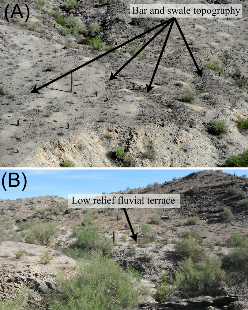
The surface morphology of an ambiguous landform can be compared to nearby features. For example, (A) the alluvial fans at South Mountain, Arizona, are characterized by pronounced heavily varnished bars separated by lower and less varnished swales. Debris flows produce this basic topography of alternating bars and swales. (B) In contrast, the stream terraces at South Mountain are typified by low relief and relatively planar surfaces. Saguaro cacti (Carnegiea gigantea) and Paloverde trees (Parkinsonia microphylla) provide scale.
3 Criterion III: sedimentology
If the underlying alluvial sediments are fanglomerate and show no interruption by the truncating stream, then it is likely that the landform is a toe-cut terrace. There may be a few emplaced fluvial clasts from the trunk drainage at exposure, but fanglomeratic deposits should be the dominant form and are usually distinguished by coarser clasts within a finer-grained matrix. The coarse clasts are subangular to subrounded and more poorly sorted than other fluvial deposits. The surficial expression of fanglomeratic deposits are often a bar-and-swale topography as distinguished in criterion II. In contrast, other fluvial deposits tend to be well sorted and rounded if they are boulders and cobbles or will show sorting between sandy and gravel facies. Sedimentological analysis of clast characteristics should be used with caution as the far distal portion of large fans may contain very fine deposits that could resemble deposits originating from other fluvial transport processes. Provenance, described in criterion IV, may help resolve this.
4 Criterion IV: provenance
Provenance can sometimes serve as a useful tool in distinguishing between these landforms. This is particularly significant in large drainage basins like those investigated by Colombo et al. (2000) in Argentina (cf. Figure 4). Alluvial fan sediments entering a drainage from a tributary basin derive from a local source (Brierley et al., 1993; Hereford et al., 1996). On the other hand, the major trunk drainage will host a mix of rock types from throughout the upstream portions of its drainage basin. Sedimentological provenance is best applied with larger drainage basins or if the geology of a tributary drainage is particularly complex or unique (Duk-Rodkin et al., 2001; Mather, 2000). The use of detrital zircons or identification of chemically distinct lithologies (e.g. mineralogically distinct basalts) may help differentiate between the origins of the deposits.
5 Criterion V: longitudinal profiles
A common method for investigating fluvial terraces compares the longitudinal profiles of terraces to the modern fluvial channel. This comparison reveals insight into the nature of incision, local tectonics, and underlying bedrock (e.g. Merritts et al., 1994; Pazzaglia et al., 1998; Zuchiewicz, 2011). Longitudinal profiles can also prove useful in distinguishing toe-cut terraces from other fluvial terraces. Convexities may exist along the longitudinal profile. If these convexities correspond with the physical location of tributary drainages, then they could represent the topographic effect of alluvial fan material derived from side tributaries.
Another way that longitudinal profiles may distinguish a toe-cut terrace from a fluvial terrace involves identifying whether profiles of the modern channel converge downstream or remain parallel to the terrace form. In many drainages in the Basin and Range of the Western USA, the long profiles of contiguous toe-cut terraces merge with the modern channel. This is the result of an increasing width of the valley form. As the axial valley widens, progressively more distal fan sediments reach the trunk drainage and the relief of the fan surface decreases with increasing distance away from the mountain front. If the valley widens enough, the fan surfaces merge with the modern channel. In contrast, other fluvial terraces remain parallel and topographically above the modern channel. The one caveat to be aware of when using this criterion is that tectonic uplift of the tributary valley will also produce downstream convergence of terrace treads (e.g. Pewe, 1978); however, if tectonic activity can be ruled out, then convergence would indicate that the abandoned alluvial surface is likely a toe-cut terrace.
6 Criterion VI: comparisons with local drainage basins and establishing a chronology of incision events
Drainages do not exist in isolation. The forms found in a basin typically exist next to adjoining drainages with similar characteristics (i.e. underlying lithology, topography, climate, tectonic regime, etc.). Examination of these adjacent drainages can help provide a broader perspective, in that a slightly wider or narrower adjacent drainage could display more classic alluvial toe-cut terraces or traditional fluvial terrace forms. The clarity of forms in nearby drainages with similar lithologies and slightly different geometries can provide a fresh perspective to clarify the origin of the terraces in the basin under study.
Another strategy involves comparing the chronology of events between drainages, either through relative (i.e. superposition, fossils, etc.) or more quantitative chronometric techniques (i.e. optical stimulated luminescence, radiocarbon dating, cosmogenic nuclide burial dating, or varnish microlamination dating). Fluvial terraces may have a very different chronology than toe-cut terraces, and a comparison of ages in a local range or region can help distinguish fluvial from alluvial fan deposits while also shedding light on the nature of geomorphic change in the study area.
IV Case study: Bursera Valley, Central Arizona
1 Geomorphic setting of the study area
The Bursera Valley (BV) rests entirely within the South Mountains (SM) of central Arizona (Figure 8). SM stretches approximately 29 km in length, is a city park preserve located just south of metropolitan Phoenix, Arizona, USA, and hosts ˜2 million visitors each year. The Bursera Wash resides within a gneissic structural valley in the western half of SM (Reynolds, 1985). Previous research (Dorn, 2010; Dorn, 2011; Larson, 2013; Larson and Dorn, 2014; Moore et al., 2012) revealed the dominance of alluvial fans within the gneissic portion of SM, which suggests that this valley, too, should be dominated by alluvial fans.
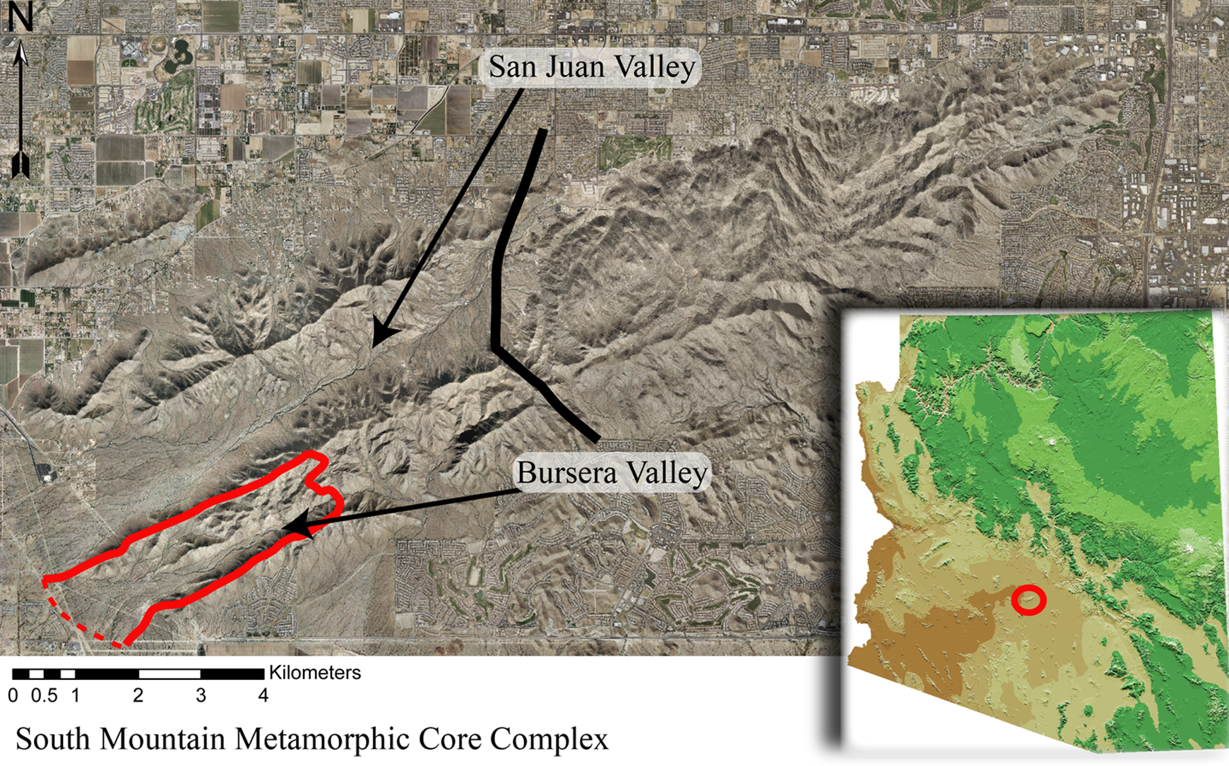
The Bursera Valley rests entirely within the South Mountain metamorphic core complex (SMCC) of central Arizona, USA. Its drainage basin is outlined on the image and flows to the southwest where it grades into the Gila River and basin fill deposits. A solid line through the middle of South Mountain delineates the boundary between lithologies. West of the line, drainages are underlain by metamorphic rock and contain alluvial fans as the dominant alluvial landform. East of the line the range is underlain by plutonic rock, which forms semi-continuous fluvial terrace surfaces. The perspective of lighting in this image is from the south so shadows are cast to the north.
We offer the Bursera Valley as a case study, because—as can be the case in narrow valleys—upon initial observation, different prominent terrace levels look very much like fluvial terraces (Figure 9). The most prominent and highest terrace in BV forms a near continuous surface throughout the valley. In many locations alluvial fans topographically transition to this surface, but in other locations it is difficult to interpret the nature of this landform. Three lower, discontinuous terrace surfaces exist in the downstream reach of the BV, and are identifiable as fluvial terraces inset into the highest surface. We named these terraces after convention from topographically low to high—T1, T2, and T3. Thus, this case study focuses on the ambiguous uppermost terrace in the Bursera Valley herein referred to as F4.
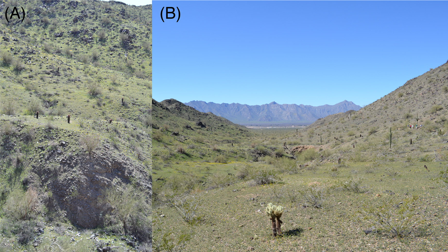
Bursera Valley displays abandoned alluvial surfaces that look very much like fluvial terraces upon first inspection; however, upon further investigation they are alluvial toe-cut terraces. Both images are from the highest terrace form in the Bursera Valley. Image (A), looking across the valley and image (B), looking down valley, show the relatively low relief surface topography of the upper terrace surface that could be misconstrued as a fluvial terrace.
2 Applying the criteria to the Bursera Valley
All of the criteria were used to analyze the highest BV terrace surface. However, provenance proved inconclusive because the BV has a similar gneissic lithology throughout the entire drainage basin (Reynolds, 1985).
1 Landform morphology
From some perspectives the view of toe-cut terraces can look strikingly similar to traditional fluvial terraces (Figure 9). However, a different perspective can often uncover the origin of a tread and riser—revealing that it may originate from a tributary drainage. Retracing alluvial surfaces, however, is not always possible or is exceedingly difficult if multiple episodes of adjustment have occurred in the drainage basin.
The F4 surface, in some instances, is not easily traceable to an alluvial fan. Thus, it becomes difficult to determine the genesis of this landform using landform morphology alone and necessitates the need for other criteria. Some of the complication arises because alluvial fans have been truncated by the Bursera Wash, which has resulted in segments of the fan surface preserved on opposite sides of the BV. Figure 10 shows just such an instance.

Dashed lines in both (A) and (B) indicate the direction of flow of the Bursera Wash from opposite sides of the BV at a similar location. In (A) a prominent semi-continuous terrace form appears above the wash. From the opposite perspective (B) a large tributary drainage empties into the main valley. Vertical white arrows point to landforms that appear to be fluvial terrace surfaces. However, the terrace form in the foreground of (A) is toe-cut terrace from the tributary shown in (B) and the bench like forms on the opposite side of the valley in (A) are the result of both the alluvial fan in (B) and colluvial deposits on that side of the valley. The Bursera Wash truncated the fan in (B) resulting in part of the fan surface being isolated on the opposite side of the BV.
2 Form of deposition on the surface
The T1 fluvial terrace surface of BV consists of a smooth sandy surface with few pebbles. Desert pavements comprising mostly gravels and pebbles rest atop the T2 and T3 fluvial terraces. In contrast, the surface of the F4 terrace form frequently contains bar-and-swale topography (Figure 11A) that mimics the bar-and-swale forms seen on tributary canyon alluvial fans within the BV (Figure 7).

Alluvial fan and fluvial terraces are often strikingly different in regard to their surface morphology and sedimentological characteristics. In a surficial setting, fanglomerate often takes the shape of bar-and-swale deposits (A), while river boulders and cobbles tend to show rounding and imbrication (B). In exposed cuts, fanglomerate exhibits poor sorting and more angular clasts (C), whereas fluvial deposits exhibit the opposite (D). All images from South Mountain, AZ, USA.
3 Sedimentology of the deposit
Unlike the sorted sandy and gravel lenses that occur in the fluvial terrace T1, T2, and T3 deposits, the higher terrace form consists of classic sequences of fanglomeratic deposition (Figure 11C). While it is certainly possible that the upper Bursera drainage basin generated debris flows, the orientation of the fanglomerate bedding planes are consistent with origins in side tributary canyons. Clasts within the highest terrace surface are angular to subangular and are poorly sorted throughout the Bursera Valley, indicative of a locally sourced fanglomerate (Figure 11C).
4 Longitudinal profiles
Slope survey data, collected using a dGPS (differentially corrected global positioning system), and longitudinal profiles of both the F4 and the modern channel (Figure 12) reveal that the highest terrace is a continuous surface found along the entire reach of BV.

The longitudinal profiles shown were developed using differentially corrected GPS. The highest terrace surface in the Bursera Valley is shown in comparison to the channel. The terrace surface profile is that of the highest terrace in BV. The longitudinal profile reveals convexities related to tributary alluvial fans. Those noted as “possible” correspond to locations where tributary streams join the axial drainage. The striking elevational changes of the channel shown upstream are due to poor GPS signal reception in the narrowest portions of the canyon.
The convergence of the high terrace with the modern channel at the distal end of the drainage basin (Figure 12) could represent a fluvial terrace altered by active uplifting of SM. However, tectonic uplift of SM has been inactive for the last 6 Ma (Reynolds, 1985; Reynolds and Bartlett, 2002). An alternative explanation for convergence is that BV widens progressively downstream. Valley widening allows the distal, progressively lower portions of alluvial fans to converge with the modern channel. In contrast, a narrower valley in the upper reaches means that truncation of alluvial fan surfaces can preserve a toe-cut terrace above the modern channel.
Another set of features associated with the longitudinal profile of the terrace also support toe-cut terrace genesis of the high, F4 terrace. The terrace profile reveals five prominent convexities (Figure 12) associated with the larger tributary valleys that feed alluvial fan sediment toward the valley axis.
5 Comparisons with local drainage basins and establishing a chronology of incision events
In comparing the BV with other drainages within SM a prominent pattern emerges. First, drainages in the western (metamorphic) portion of the range are dominated by alluvial fans, while traditional fluvial terraces dominate the eastern (plutonic) portion of the range (Dorn, 2010; Dorn, 2011; Larson and Dorn, 2014; Moore et al., 2012). Second, a distinct contrast in both surface morphology and sedimentological characteristics of the alluvial landforms exists (Figure 11). The eastern drainages generate grus with well-sorted deposits and host channels in the upper portions of the drainage laden with subround to round clasts (Figure 11B and D). The western drainages generate subangular to angular clasts that are poorly sorted and show bar-and-swale surficial topography indicative of debris-flow deposition (Dorn, 2010; Moore et al., 2012; Figure 11A and C).
To provide age control and to establish a chronology of incision events, varnish microlamination correlation dating (VML) was applied to terrace surfaces within the Bursera Valley (Figure 13). VML has shown a high degree of effectiveness in dating surficial deposits in the arid southwest USA (e.g. Dorn, 2010; Friend, 2000; Friend et al., 2000; Liu and Broecker, 2007; Liu and Broecker, 2008a; Liu and Broecker, 2008b; Liu and Broecker, 2013). Blind testing (Liu, 2003; Phillips, 2003) of VML shows that there is “convincing evidence that varnish microstratigraphy is a valid dating tool to estimate surface exposure ages” (Marston, 2003). Given that VML was successfully used previously to date alluvial fan surfaces elsewhere on South Mountain (Dorn, 2010; Moore et al., 2012), we utilized VML to compare the Bursera Valley terrace surfaces to these other nearby alluvial landforms.
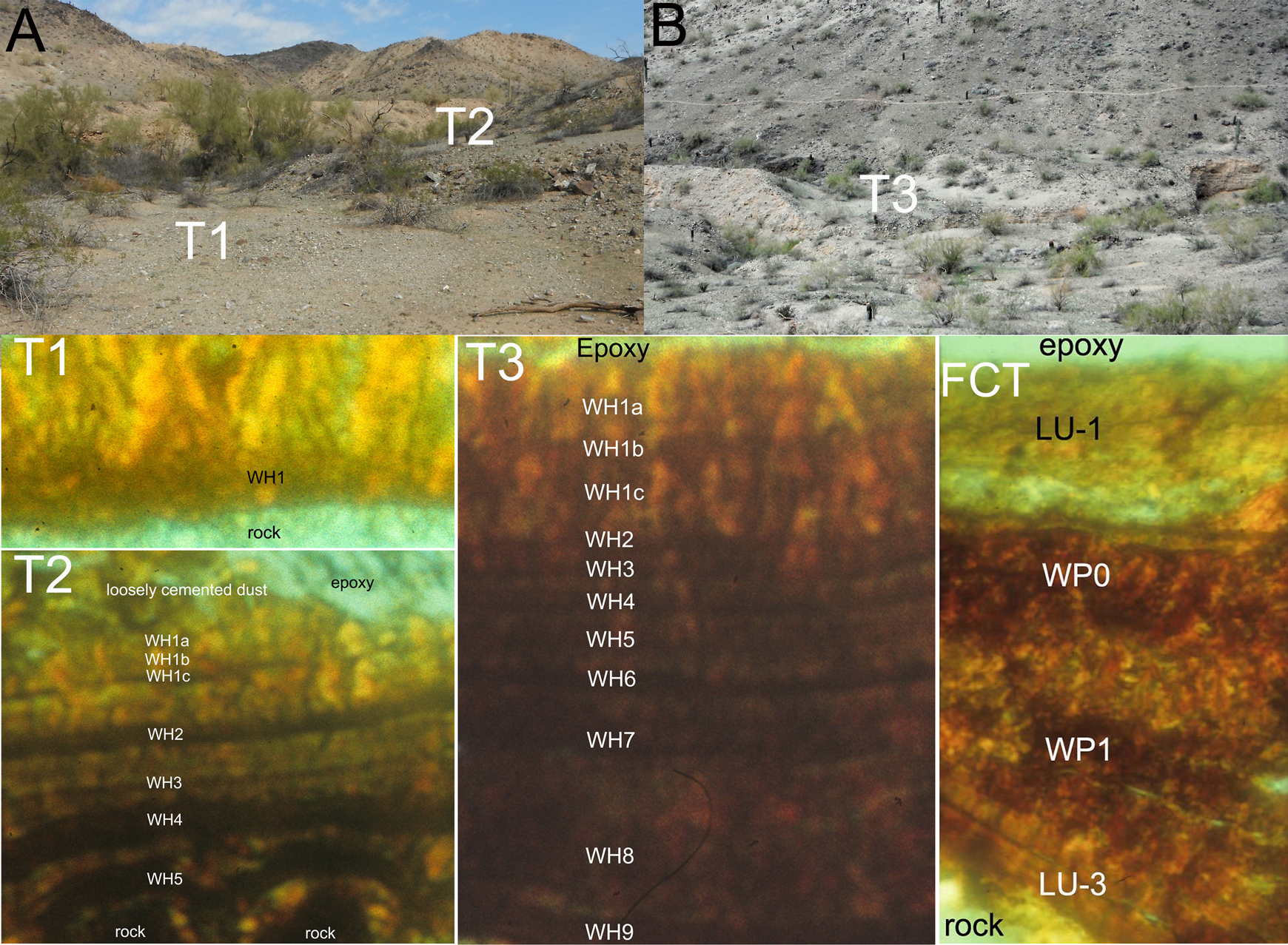
The abandonment of the high terrace within Bursera Valley corresponds with the abandonment of alluvial fans found elsewhere within South Mountain and is chronologically older than the fluvial terrace surfaces inset within it (T1, T2, T3). T1, T2, and T3 incision events have possible linkages to other regional river system fluctuations. Based on the VML dating the highest terrace surface in the Bursera Valley (FCT) shows surface abandonment between 16.5 ka and 24 ka. The next highest terrace, T3, shows abandonment before 8100 cal yr BP. T2 reveals abandonment before 4100 cal yr BP. T1 shows a Little Ice Age signal of 300–650 cal yr BP. The microstratigraphic varnish layers are labeled using the established layering units of the VML dating lab at Columbia University. For example, LU-3 represents “layering unit 3”, while layers labeled WH or WP represents “wet Holocene” or “wet Pleistocene”.
VML analysis reveals that the abandonment of the F4 surface within BV occurred before or during the LU-3 (Layering Unit 3, Liu, 2011) period, 16.5–24 ka (Figure 13). The LU-3 VML signal of the F4 surface correlates to the most common age for abandonment of and incision into extensive alluvial fan deposits found throughout the western half of South Mountain (Dorn, 2010; Moore et al., 2012).
In contrast, the inset fluvial terraces in Bursera Valley are progressively younger. The T3 fluvial terrace surface was abandoned before or during VML event WH9 (Wet Holocene Event 9, 8100 cal yr BP); the middle T2 terrace was abandoned before or during WH5 (4100 cal yr BP); and the lowest T1 terrace was abandoned during the Little Ice Age’s WH1 event (300–650 cal yr BP). These ages correlate regionally with other fluvial terraces, such as the post-Lehi incision event of the Salt River between 940 and 300 cal yr BP (Huckleberry et al., 2012). The older T2 and T3 terrace VML ages correlate to flooding events in the cumulative probability density function plot for rivers within the southwestern USA (Harden et al., 2010). In summary, the ages of the non-toe-cut fluvial terraces in BV correspond with other, more recent, incision events in the region. In contrast, the age similarity of the ambiguous F4 terrace with other alluvial fans in the range (Dorn, 2010; Moore et al., 2012) does not prove a toe-cut origin; however, it does provide important evidence that aligns with a toe-cut terrace interpretation. It is important to note that the VML layering units used to determine alluvial surface abandonment are not absolute ages, but instead represent an age range when the rock varnish began to accumulate. It is likely that precise, absolute ages would reveal a time-transgressive signal on the various terraces studied, as base-level lowering progressed throughout the drainage basin. In the case of the LU-3 signal on the F4 terrace, the time-transgressive signal was most likely incorporated within the 7.5kyr age range, thus, we do not see a time-transgressive signal.
6 Analysis of the criteria-based approach
In the context of the Bursera Valley study site, all available criteria indicate that the high terrace, F4, is a toe-cut terrace despite appearances to the contrary. None of the criteria support a traditional fluvial terrace interpretation. Fluvial terraces do exist, but are inset beneath the toe-cut terrace surface and have a different and distinct genetic origin.
Toe-cut terraces in this case study formed as a result of aggradation of an alluvial fan surface, followed by base-level lowering induced by incision of the Bursera Wash. Base-level change resulted in a wave of incision that propagated headward up the tributary fans. Some small toe-cutting by the Bursera Wash has occurred; for example, the cut exposing the fanglomerate in image Figure 11C likely involved some lateral erosion. However, toe-cut terrace genesis relates mostly to base-level lowering by incision of the Bursera Wash.
V Conclusion
Alluvial fans commonly feature scarps at their distal end produced when a stream erodes the fan toe. Researchers currently use six different terms to describe abandoned alluvial surfaces that form by the truncation of tributary alluvial fans by a drainage basin’s trunk stream. A terminological confusion and morphological similarities between terrace forms may have been responsible for misinterpretations of toe-cut terraces as traditional fluvial terraces in the past. Thus, we propose that future research employs the term “toe-cut terrace”. Confined spaces like the Bursera Valley study explored herein exemplify a situation where forms that look very much like a fluvial terrace are in reality a toe-cut terrace. To help minimize the potential for future problems, we propose several criteria to help distinguish between toe-cut terraces and traditional fluvial terraces within a drainage basin in the arid environment. These criteria are focused on differentiation of terrace forms within the Basin and Range, but may be applicable elsewhere. Employment of these criteria in the Bursera Valley case illustrates their potential.
Footnotes
Funding
This research received no specific grant from any funding agency in the public, commercial, or not-for-profit sectors.