



Abstract
Ecological restoration can result in extensive land use transitions which may directly impact on water runoff and sediment loss and thus influence tradeoffs between multiple hydrological and soil ecosystem services. However, quantifying the effect of these transitions on runoff and sediment yields has been a challenge over large spatial scales. This study integrated and synthesized 43 articles and 331 runoff experimental plots in the Loess Plateau of China under natural rainfall to quantify the impacts of land use transitions on (a) runoff and sediment production, (b) runoff and soil loss reduction effectiveness, and (c) the tradeoffs between runoff and soil erosion. The effects of ecological restoration on runoff and sediment yields were quantified using a general mixed linear meta-regression model with a restricted maximum likelihood estimator on overall and individual ecological restoration types. The results showed that artificial grassland, forest, natural grassland, and shrubland had higher runoff and sediment reduction effectiveness. The annual runoff reduction effectiveness of the ecological restoration overall was 72.18% with the effects of artificial grassland, natural grassland, shrubland, and forest at 71.89%, 50.60%, 73.18%, and 73.08%, respectively. The annual sediment reduction effectiveness of the overall ecological restoration was 99.9% without a significant difference among the four land uses associated with ecological recovery. In addition, shrubland and forest significantly reduced sediment yields with relatively high runoff costs. Natural grassland was optimal for balancing water provisioning and soil conservation, and artificial grassland was second to natural grassland in this respect. Meanwhile, newly unmanaged abandoned land and cropland had relative weak functionality with regard to soil and water conservation. The implications of this study’s findings are discussed along with their potential to contribute to an improved understanding of the effects of ecological restoration on water supply and soil retention for the water-limited terrestrial ecosystem at a regional scale.
I Introduction
Soil erosion by water has been a serious environmental problem and a threat to the sustainability and productive capacity of agro-ecosystems (Lal, 1987; Pimentel and Kounang, 1998; Pimentel et al., 1995). Ecological restoration is an important approach for controlling land degradation caused by soil erosion and for improving soil ecological function. In semi-arid and arid regions, ecosystem services that promote water provision and soil retention by ecological restoration initiatives are critical to ensure the sustainability of socio-ecological systems. Water provisioning and soil retention services are closely related to water and soil processes, especially runoff and sediment processes which are extremely sensitive to land use and vegetation cover changes arising from ecological restoration initiatives (Brauman et al., 2007; Robinson et al., 2013).
Historically, field observation has been the most commonly used and reliable method for determining the effect of ecological restoration on runoff and sediment yields. Specifically, runoff experimental plots are used to conduct field observations where vegetation, soil, and topography were considered to be relatively homogeneous (Kinnell, 2016). Studies have revealed that land use types, the magnitude and timing of rainfall, soil erodibility, and micro-topology can each have important impacts on runoff and sediment processes at the plot scale (Boix-Fayos et al., 2006). The formation of vegetation patch patterns, a complex canopy structure, high soil hydraulic conductivity, and an increase in plant functional diversity have been found to promote soil and water retention when ecological restoration has altered the bio-physical environment through natural succession (Imeson and Prinsen, 2004; Hou and Fu, 2014a; Hou et al., 2014a; Zhou et al., 2016). The implementation of ecological restoration interventions can also incur synergies and tradeoffs among multiple soil- and water-related ecosystem services (Fu et al., 2015; Jia et al., 2014; Power, 2010). Coarse indicator-based methods have been used to estimate potential tradeoffs between water yield and soil retention, but can suffer from insufficient support from field observations (Dymond et al., 2012; Hao et al., 2017; Trabucchi et al., 2013; Zheng et al., 2014). Observations from field runoff plots on hill-slopes can provide the basis of a more accurate and direct method for choosing optimal land use types for ecological restoration, with the objective of promoting soil and water conversation. Plot scale studies have used runoff cost for sediment control as a simple indicator to quantify the effect of different tillage and biological measures on the tradeoff between runoff yields and soil loss (Yan et al., 2012, 2015). However, it is often difficult to scale up plot or field observations to regional processes, even from multiple field sites, because the sites may not adequately sample (or represent) the region. For example, they may employ different measurement methods, perform experiments over different time periods or have insufficient treatment repetitions (Boix-Fayos et al., 2006; Garcia-Ruiz et al., 2015; Labriere et al., 2015).
One way to develop regional-scale understandings of soil and erosion processes through field scale studies is through a meta-analysis. This approach synthesizes and analyzes available data from multiple sites and other sources, and attempts to overcome variations in study contexts and inconsistencies in their conclusions. Meta-analysis is an effective tool for exploring the regional impacts of local land use change together with soil and water conservation interventions on runoff and soil erosion processes. A meta-analysis approach has been used to investigate the effects of land use types on annual soil loss, annual runoff, and annual runoff coefficients from field-scale data in Europe and the Mediterranean region (Maetens et al., 2012). It has also been used to study the effectiveness of soil and vegetation management on soil erosion control in the humid tropics where soil erosion was found to be concentrated both spatially (over the landscape elements of bare soil) and temporally (e.g., during crop rotation) (Labriere et al., 2015).
Although many descriptive reviews and perspectives on soil erosion and conservation exist (Chen et al., 2007; Haregeweyn et al., 2015), no quantitative meta-analysis has been done to integrate plot-scale data and findings, in support of a broader understanding of land use change and its hydrological and soil erosion impacts for the Loess Plateau in China. The Loess Plateau has a well-known and long history of heavy soil erosion due to an increasing amount of susceptible land use types, such as bare land, sloped cropland, and abandoned land. It has been a research hotspot for soil erosion studies and has been subjected to many soil and water conservation measures since the early years of New China (Chen et al., 2007; Chen et al., 2015; Zhuang et al., 2015). During the past decades, many soil and water retention and ecological restoration projects have been implemented to reduce soil erosion and to promote vegetation recovery, especially through the “Grain-for-Green” project launched in 1999 (Chen et al., 2007). These projects promote the transition from degradation susceptible land to degradation-resistant land types such as artificial or natural grassland, shrubland, and forest, which has made the Loess Plateau the most significant vegetation greening zone in China (Lu et al., 2015; Vina et al., 2016). These land use transitions effectively control soil erosion and reduce runoff in this water-limited area (Chen et al., 2015; Feng et al., 2016; Wang et al., 2016). In addition, observations at extensively distributed field plots have been widely used to directly monitor runoff and sediment yields on the Loess Plateau (Chen et al., 2007). Studies have focused primarily on the effect of land use types on runoff and sediment production at the local scale (Fu et al., 2004; Kang et al., 2001; Wang et al., 2011; Zhang et al., 2015; Zhou et al., 2016). However, current studies have paid little attention to the regional effects of ecological restoration on soil and water retention, regardless of sufficient support by observation data.
Thus, in this study, we integrated field plot scale monitoring to quantify the effect of ecological restoration on hydrological and soil erosion via a meta-analysis. Our main objectives were to: (a) determine the impact of land use type on runoff and sediment yields across the entire Loess Plateau; (b) identify the tradeoffs and synergies between runoff production and soil erosion under different land use types; and (c) evaluate the overall and land use specific effectiveness of ecological restoration on soil and water retention. Such an approach can inform and support an improved understanding of the effects of regional-scale land use transitions and can facilitate future large-scale ecological restoration planning and sustainable management. At the same time, this study can complement global-scale studies, especially in other loess regions around the world.
II Material and methods
1 Literature search and data extraction
To collect the meta-analysis data, we searched peer-reviewed journal articles published both in English and in Chinese using the ISI Web of Science and China National Knowledge Infrastructure (CNKI) (from January 1990 to May 2016). We used the following search-term combinations: “runoff” or “streamflow” or “discharge” or “water yield” or “water provision,” and “soil erosion” or “sediment load” or “sediment delivery” or “sediment discharge” or “sediment yield*” or “sediment*”. We then refined our search with keywords “Loess Plateau” or “* middle * Yellow River.” EndNote X7 software was used to manage documents, remove duplicates, and screen titles, abstracts and full texts in order to include or exclude studies. Engauge Digitizer software was used to help with extracting numerical data from scatter-plot, box-plot, and bar-plot figures. In addition, we considered further studies cited in the references and studies published as dissertations. A final data set of 43 articles and 331 plots were included in our meta-analysis (see Appendices 1 and 2 in the online supplementary material) that met the following criteria for inclusion. The experiments were conducted in the region of the Loess Plateau and in the middle reach of the Yellow River. The experiments were conducted in the field under natural rainfall events. The spatial scale of observation was the runoff experimental plot, with relatively homogeneous site conditions and responses to different land cover transitions. The study at least partly recorded variables describing runoff or sediment and the following associated factors: land use type, area, slope length, slope steepness, soil properties, and restoration duration. Means, standard deviations or standard errors, or sample sizes of treatments and controls were directly reported or could be determined from the main text of the articles.
The 43 selected studies were mainly conducted in the hilly-gully region of the Loess Plateau (Figure 1) and were diverse in their specific characteristics: the duration of monitoring, the number of land use types, and site conditions (see Appendix 2). Because runoff and erosion events happen mainly during the growing season (from June to September) on the Loess Plateau, we focused on the growing season and associated runoff events and soil erosion events. Annual runoff and sediment yields were obtained by summing rainfall event runoff and sediment yields for the entire growing season. The growing season and event rainfall were used to calculate a runoff coefficient to describe the likelihood of yielding runoff.

Location of study sites (N = 43). Some sampling points represent several references, and some references contribute more than one sampling point.
2 Data characteristics and preprocessing
The first stage of the analysis was to determine the characteristics of the data sources and the data. The year of publication indicated that research articles were concentrated in 2004, 2006, and the last five years (Figure 2(a)). Although, the duration of the 43 studies ranged from one to 14 years, most took fewer than five years (Figure 2(b)). The number of land use types was generally less than four and all studies examined two temporal scales: years and rainfall events (Figure 2(c) and (d)). The research sites were distributed across four provinces (Shanxi, Shaanxi, Ningxia, and Gansu) and across 21 counties (Ansai, Baota, Changwu, Dingxi, Fu, Fugu, Guyuan, Huining, Ji, Lishi, Pingshuo, Shenmu, Shouyang, Tianshui, Wuqi, Xifeng, Yanggao, Yichuan, Yongshou, Yulin, and Zizhou) (Figure 2(e)). Using the classification of annual soil erosion rates from Jing (1986), most of the annual soil erosion rates were found to be less than 20 t/ha among seven land use types, but for bare land, abandoned land and cropland, large rates were found at 20–50 t/ha, 50–100 t/ha, and more than 100 t/ha. Abandoned land had the highest annual soil loss rate of more than 100 t/ha (Figure 2(f)). The compiled datasets were considered sufficiently rich and representative to be used for a meta-analysis.
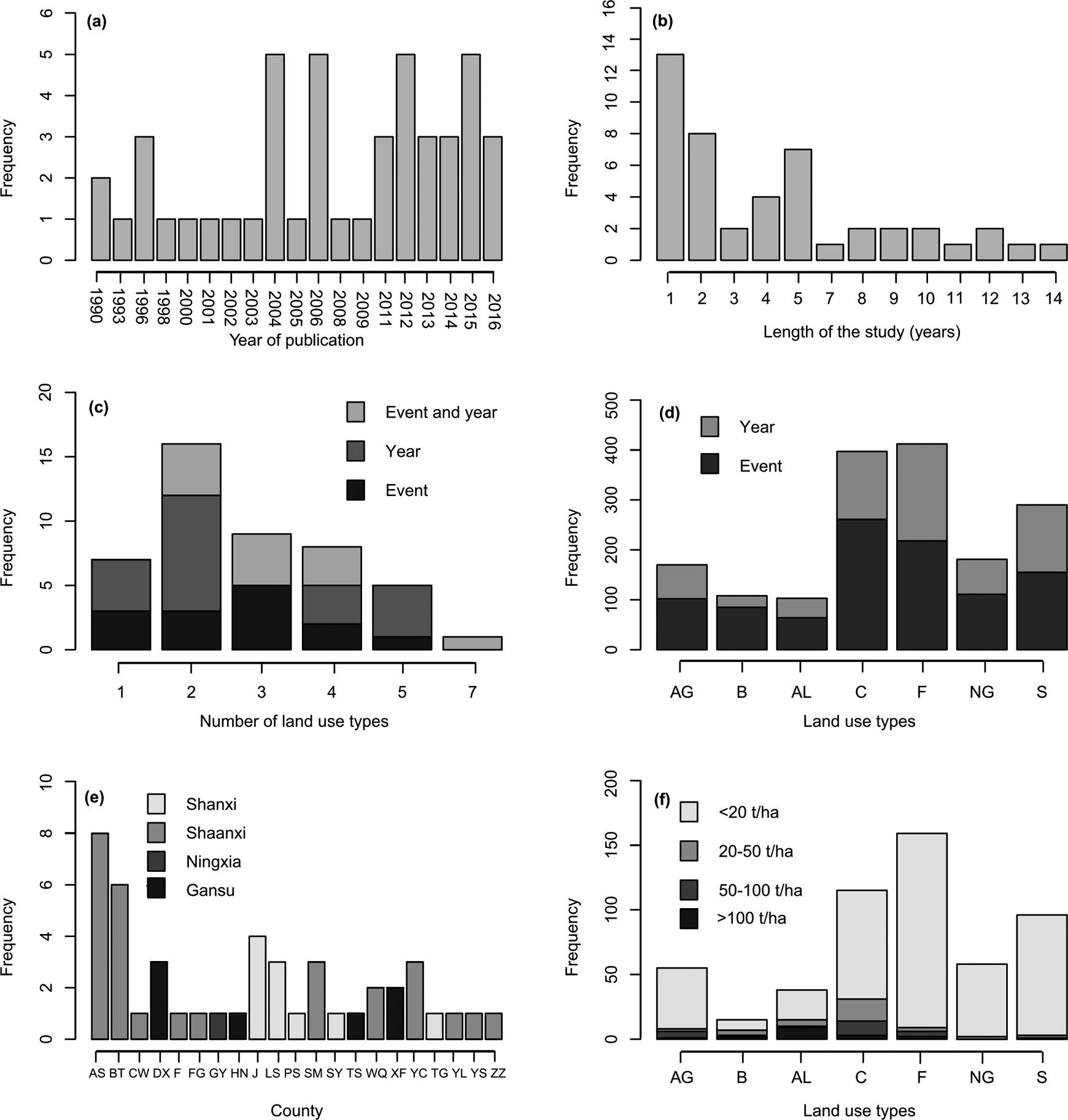
Frequency distribution of (a) year of publication of the contributing references (N = 43), (b) length of the study, (c) number of land use types investigated per reference, and (d) land use types investigated, (e) the number of case studies located at different counties and provinces, (f) levels of annual soil erosion rate under different land use types. Abbreviation of land use types can be found in Table 1. Event: soil erosion or runoff at an event scale; Year: soil erosion or runoff at annual scale; Event and year: soil erosion or runoff at an event and annual scale; AS: Ansai; BT: Baota; CW: Changwu; DX: Dingxi; F: Fu; FG: Fugu; GY: Guyuan; HN: Huining; J: Ji; LS: Lishi; PS: Pingshuo; SM: Shenmu; SY: Shouyang; TS: Tianshui; WQ: Wuqi; XF: Xifeng; YG: Yanggao; YC: Yichuan; YS: Yongshou; YL: Yulin; ZZ: Zizhou.
Land use transition types and land use types adopted in our study can be found in Table 1. Each land use type was occupied by a different dominant plant species. Forage grass species (e.g., Astragalus adsurgens, Medicago sativa, and Astragalus complanatus R. Ex Bge.) was commonly found on artificial grassland plots, whereas natural grassland plots were occupied through natural succession mainly by wild species, including Agropyron cristatum (Linn.) Gaertn., Cleistogenes squarrosa (Trin.) Keng, Heteropappus altaicus (Willd) Novopokr, Setaria viridis (L.) Beauv., Stipa capillata Linn., Artemisia scoparia waldst.et Kit, Stipa bungeana Trin, and so on. Forest plots mainly included tall trees, such as Pinus tabulaeformis Carr., Armeniaca sibirica (L.) Lam., Populus simonii Carr., and Robinia pseudoacacia Linn. Shrubland plots mostly contained shorter shrub species such as Caragana korshinskii Kom., Hippophae rhamnoides Linn., Spiraea pubescens Turcz., Lespedeza davurica (Laxm.) Schindl., and Amorpha fruticosa Linn. Crops such as millet, potato, sorghum, and soybean were cultivated on sloped cropland, and newly abandoned land that was farmland or fallow over a relatively short time period and had relatively low vegetation coverage. Most of the bare land plots had no plant cover and vegetation coverage was approximately zero.
The description and relationship between land use transition types and land use types.

3 Data analysis
Before conducting a detailed analysis, all data were transformed to uniform units to make runoff and soil erosion data comparable across all studies. Here, the runoff unit and soil erosion rate were transformed to mm and g/m2, respectively. Next, descriptive statistics were generated to visualize the interactions between land use, runoff, and soil loss, using box-plots grouped by land use types. Then, runoff and soil erosion rates were log10 transformed to normalize their distribution. One-way analysis of variance (ANOVA) and Tukey’s HSD (honest significant difference) were used to test for differences (significance level at p < 0.05) in runoff and soil loss with land use types.
A range of indicators were used to quantify runoff and soil loss reduction effectiveness and runoff cost of sediment control with land use, with each land use type considered as a separate vegetation management factor, and compared with the case of bare land where plant cover was approximately zero (Table 2). In order to explore overall and individual soil and water retention effectiveness via a meta-analysis, the land use types were divided into two transition types including ecological restoration type (ERT) and land degradation type (LDT) according to their soil and water retention measures (Table 1). Firstly, ecological restoration types (ERTs) are essential soil and water conservation measures leading to land use transitions from cultivated sloping croplands to artificial grassland, natural grassland, shrubland, and forest in the Loess Plateau. Secondly, land degradation types (LDTs) are the main sources of soil loss and have poor water conservation potential, which included bare land, newly abandoned land, and cropland. Finally, we determined the soil and water retention effectiveness of the four ERTs by contrasting them with the three LDTs via a meta-analysis.
Indicators of soil and water reduction effectiveness and its tradeoff.

Specific criteria were used to expand the datasets and to calculate the effect of runoff and soil erosion rate for the meta-analysis. LDTs were treated as controls or reference scenarios, whereas ERTs containing artificial grassland, natural grassland, shrubland, and forest were regarded as treatments. We chose the natural log of the response ratio to calculate the effect size, as an alternative to the standardized mean difference (e.g., Hedges’d), which is a more restrictive method (Koricheva et al., 2013). Thus, the effect size can be calculated by the natural log of the response ratio (lnRR) as follows

with variance

where n1,
We determined the coarse spatial variability of effect size (lnRR) with longitude, latitude, mean annual precipitation (MAP) and mean annual temperature (MAT) via a regression analysis (see Appendix 3). In the meta-analysis process, model fit statistics (e.g., log-likelihood, deviance, Bayesian information criterion, and Akaike information criterion) were used to evaluate the optimal model. Model availability can be determined by the funnel and Q-Q plot between the standard error and overall effect model residuals, which can be useful for diagnosing the presence of heterogeneity and certain forms of publication bias (Viechtbauer, 2010) (see Appendix 4). The ratio of the runoff plot area, slope length, and slope steepness between ERT and LDT were regarded as continuous (numerical) moderator variables, whereas ERTs were treated as categorical moderator variables. Consequently, a generalized linear mixed meta-regression model was chosen with a restricted maximum likelihood estimator, to evaluate the mean effect size and its 95% confidence interval (CI), considering the impact of ERTs and topologic characteristics on the effectiveness of soil and water retention.
To characterize soil and water conservation effectiveness under different ERTs, the value of the overall mean effect size and the 95% CI were transformed to estimate the percentage change and other variables relative to the control percentage, using
III Results
1 Impacts of land use type on runoff and soil erosion
Average runoff depths and runoff coefficients among the seven land use types were calculated at the annual and the event scale (Figure 3). Abandoned land, bare land, and cropland had significantly higher annual runoff depths than natural grassland, shrubland, and forest (p < 0.05). Abandoned land had the highest annual runoff depth compared to other land cover types, and bare land ranked second for runoff yield. The annual runoff depth of artificial grassland was significantly higher than that of forest and lower than that of abandoned land (p < 0.05), whereas those of artificial grassland, natural grassland, and shrubland had no significant difference (Figure 3(a)). On the rainfall event scale, bare land had the highest runoff depth than those of other land use types (p < 0.05), whereas the runoff depths of shrubland and forest were significantly lower than those of artificial grassland, bare land, cropland, and natural grassland (p < 0.05), with the exception of abandoned land, which had a higher runoff depth than shrubland and forest (Figure 3(b)). In addition, the annual runoff coefficients of artificial grassland, shrubland, and forest were significantly lower than those of abandoned land, bare land, and cropland (p < 0.05), whereas the annual runoff coefficients of abandoned land, bare land, and cropland had no significant difference. Abandoned land also had the highest annual runoff coefficient, whereas the annual runoff coefficients of artificial grassland, natural grassland, shrubland, and forest had no significant difference (Figure 3(c)). Bare land had a significantly higher event runoff coefficient than artificial grassland, cropland, natural grassland, shrubland, and forest (p < 0.05), whereas the event runoff coefficients of shrubland and forest were significant lower than those of abandoned land, bare land, and cropland. The event runoff coefficient of shrubland was also significantly lower than that of artificial grassland and forest (p < 0.05) (Figure 3(d)). These results revealed that abandoned land, bare land, and cropland had relatively higher runoff yields than artificial grassland and natural grassland, whereas shrubland and forest had the lowest runoff yields but high water retention functions.
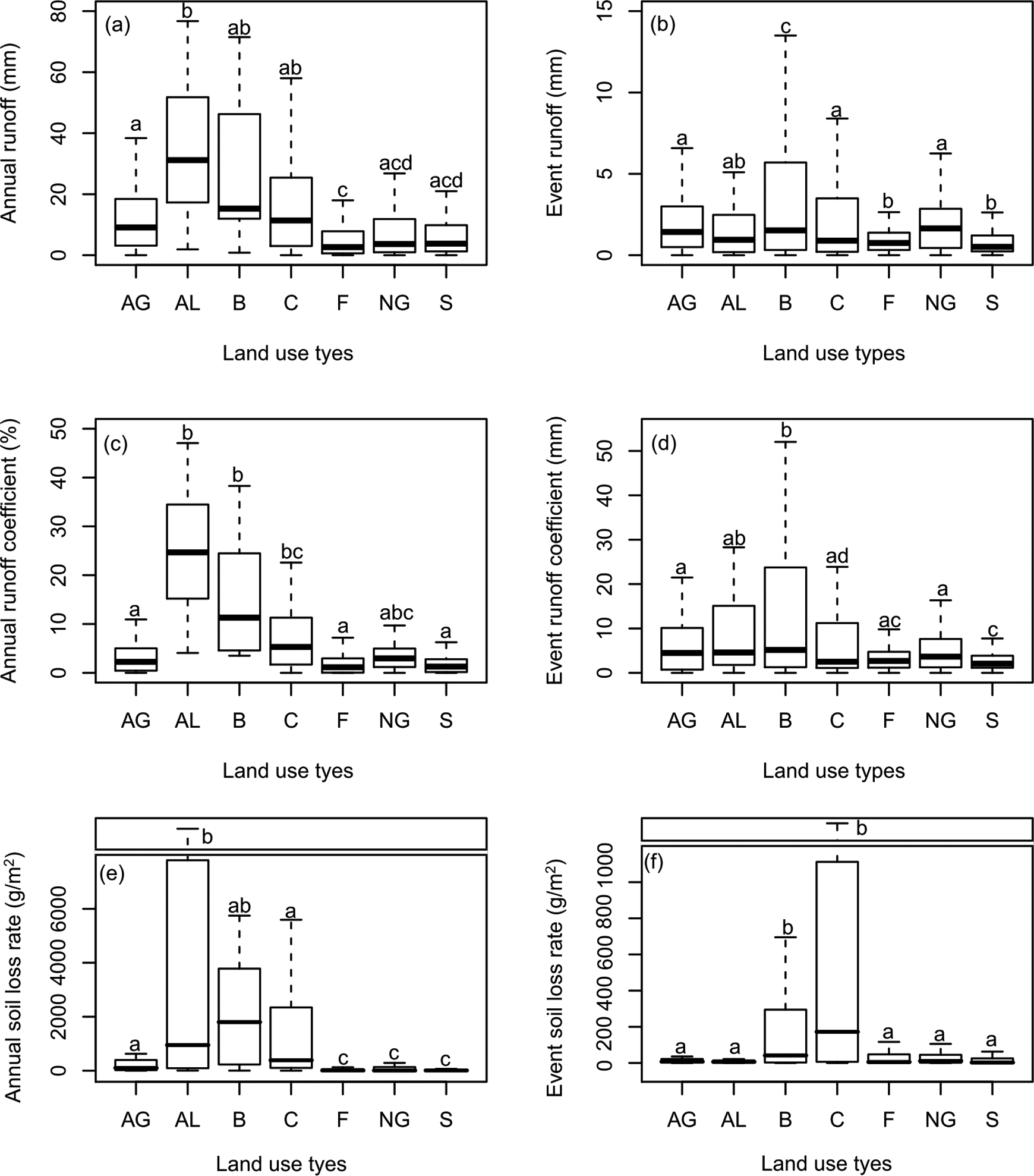
Boxplots of (a) annual runoff, (b) event runoff, (c) annual runoff coefficient, (d) event runoff coefficient, (e) annual soil loss rate and (f) event soil loss rate among seven land use types. In order to clarify the plot (e) and (f), y-axis breaks were set. The results of ANOVA and Tukey’s HSD analysis were added in the figure and the absolutely different lowercase in land use types stands for having a significant difference while just having one same lowercase denotes no significant difference. Abbreviation of land use types can be found in Table 1.
Also presented in Figure 3 are the average soil erosion rates among the seven land use types at the annual and the event scale. Artificial grassland, abandoned land, bare land, and cropland had higher annual soil erosion rates compared to natural grassland, shrubland, and forest, while those of artificial grassland and cropland were significantly lower than those of abandoned land (p < 0.05). Furthermore, the mean annual soil erosion rate of abandoned land was very close to that of bare land while artificial grassland, bare land, and cropland had no significant difference in their annual soil erosion rates (Figure 3(e)). In addition, bare land and cropland, had significantly higher event soil erosion rates than those of abandoned land, artificial grassland, natural grassland, shrubland, and forest. Also, the event soil erosion rate for cropland was the highest, with bare land second (Figure 3(f)). Although abandoned land had a relatively low event soil erosion rate, this land use had a higher ability of yielding annual runoff than cropland. At the same time, abandoned land can accumulate more soil loss at the annual scale due to abandoned land that was fallowed from cropland (Figure 3(e) and 3(f)). Results showed that natural grassland, shrubland, and forest are preferable land use types for retaining soil and water, and artificial grassland also showed a degree of improved soil and water retention effectiveness, compared to abandoned land, bare land, and cropland.
2 Soil and water reduction effectiveness and its tradeoff under different land use types
Using bare land as a reference, we calculated the runoff and sediment reduction effectiveness on the annual and event scales across six land use types (Figure 4). We found that artificial grassland, natural grassland, shrubland, and forest had relatively high annual effectiveness in retaining water. The annual runoff retention effectiveness of shrubland and forest was more than 70%, whereas that of cropland and abandoned land were about 37% and −15%, respectively (Figure 4(a)). All six land use types had relatively high event effectiveness in retaining water compared to bare land. The event runoff retention effectiveness of shrubland and forest was more than 70%, and that of cropland and natural grassland was more than 49% (Figure 4(b)). All six land use types had positive annual soil retention effectiveness compared to bare land. Except for abandoned land, with its low annual soil retention effectiveness (less than 18%), the annual soil erosion reduction effectiveness of artificial grassland, cropland, natural grassland, shrubland, and forest was more than 65%. Shrubland had the highest annual soil retention effectiveness (96.51%) (Figure 4(c)). In addition, abandoned land, natural grassland, and shrubland had relatively high event soil loss retention effectiveness (>95%), whereas that of cropland was about −150% (Figure 4(d)). These results indicated that artificial grassland, natural grassland, shrubland and forest can be considered as effective measures for retaining runoff and sediment, whereas abandoned land had low effectiveness in retaining runoff, and cropland was found to weakly decrease event sediment yields.
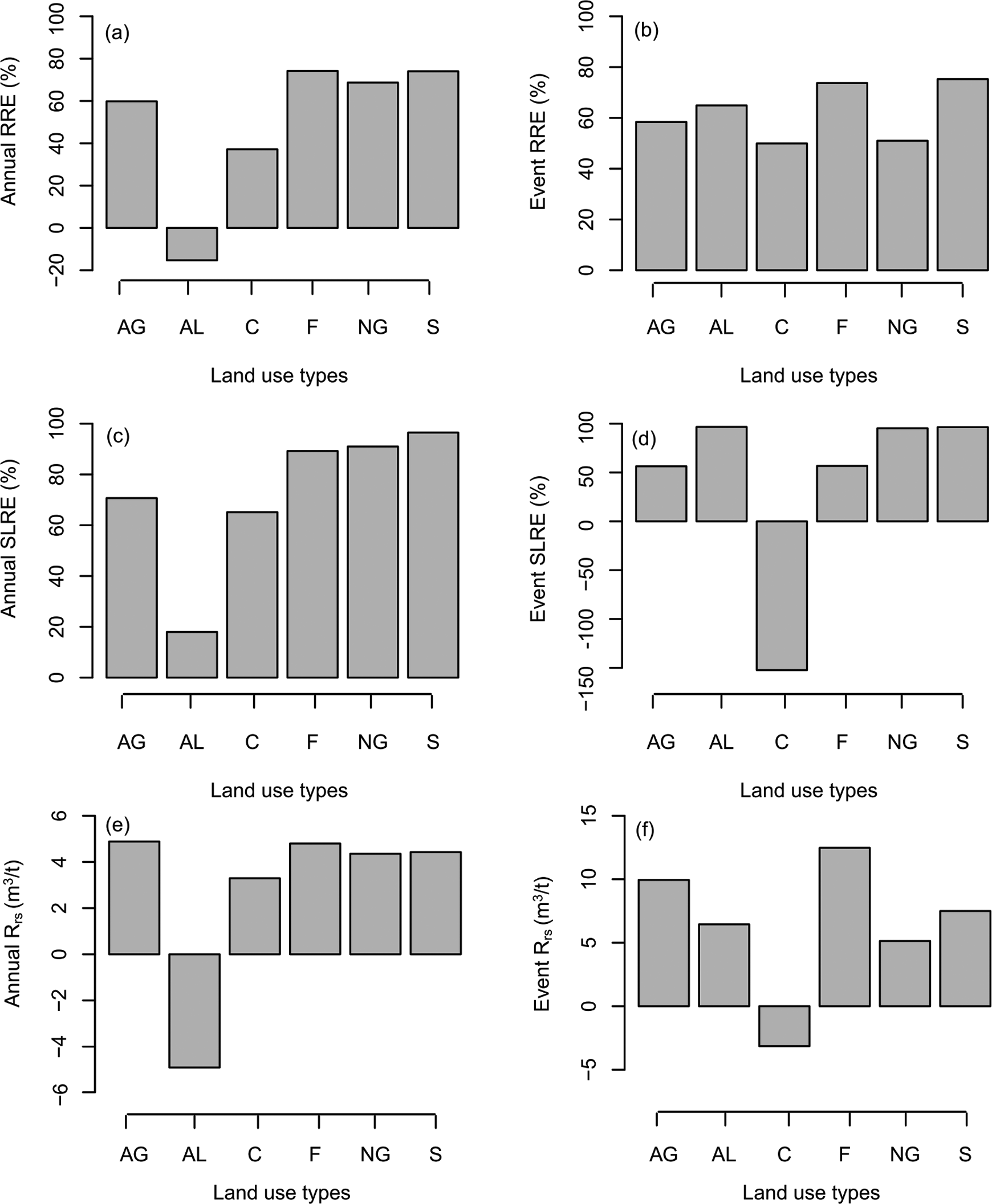
Runoff and soil loss reduction effectiveness contrasting to the control of bare land and the runoff cost of sediment control at event and annual temporal scale under six land use types. Abbreviation of land use types can be found in Table 1. RRE: Runoff reduction effectiveness; SLRE: Soil loss reduction effectiveness; Rrs: The runoff cost of sediment controlling of vegetation management factors.
The runoff cost of sediment control was used to determine the tradeoffs of different land use types at a hillslope scale for soil and water conservation, with reference to bare land (Figure 4). On an annual scale, natural grassland, shrubland, and forest had relatively high runoff costs, and that of artificial grassland was the highest (4.88 m3/t). Abandoned land was associated with greater annual runoff compared to bare land (Figure 4(e)). On the event scale, artificial grassland, forest, and shrubland had relatively higher water costs, and cropland had lower water costs than abandoned land (Figure 4(f)). These results showed that shrubland and forest significantly reduced sediment yields with relatively high runoff costs, whereas natural grassland was optimal for balancing runoff production and soil conservation and artificial grassland was also found to be effective.
3 Evaluation of soil and water retention effectiveness between ERT and LDT
Considerable spatial variability in the effect size (i.e., various lnRRs) was found along longitudinal and latitudinal gradients (see Appendix 3). Overall annual runoff depth (lnRR) significantly decreased with an increase in latitude (p < 0.05), whereas overall event soil erosion rate (lnRR) increased significantly with both latitude (p < 0.01) and longitude (p < 0.001). This spatial trend was also evident for the event soil erosion rate (lnRR). However, both the event runoff depth (lnRR) and the event soil erosion rate (lnRR) of artificial grassland significantly decreased with increased longitude (p < 0.01). These results indicated that the effect size of event runoff and soil erosion were more sensitive to changes of longitude and latitude, whereas the effect size of annual runoff was more limited to variation in latitude, only. In addition, the effect of MAP and MAT on the variability of the effect size can be found in Appendix 4. Clearly, it is critical to consider spatial heterogeneity when quantifying the overall effect of ecological restoration on runoff and soil erosion over large regions.
Ecological restoration activities had a positive effect on soil and water retention. In contrast with LDTs, ERTs significantly reduced annual runoff by 72.18% (p < 0.01) and decreased annual soil erosion by 99.9% (p < 0.0001), whereas the event runoff was reduced by 39.26%, and event soil loss was not significantly decreased (Figure 5(a) and (c)). Moderator variables effectively improved our meta-analysis model, which included the ratios of runoff plot area, slope length, and slope steepness between ERT and LDT (see Appendix 4). The overall event runoff reduction effectiveness was significantly influenced by the ratio of slope steepness and the ratio of area. The ratio of slope length were more important factor impacting the overall results for event soil erosion (Table 3). The individual effect of the annual runoff reduction effectiveness of artificial grassland, natural grassland, shrubland, and forest were 71.89%, 50.60%, 73.18%, and 73.08%, respectively. The combined effect of all the ecological restoration measures significantly reduced annual soil erosion by about 100% (p < 0.0001). However, event runoff reduction effectiveness of artificial grassland, natural grassland, shrubland, and forest were 56.41%, 21.97%, 56.97% (p < 0.05), and 36.68%, respectively. Event sediments were not significantly reduced (Figure 5(b) and (d)). In evaluating the individual effect of the ERTs, it was clear that the ratios of runoff plot area, slope length, and slope steepness have significant impacts on annual soil erosion (p < 0.0001). Annual runoff was obviously influenced by the ratios of the runoff plot area and slope steepness (p < 0.0001), whereas slope steepness was an important factor for event runoff (p < 0.05). Event soil erosion was significantly impacted by the ratios of the runoff plot area (p < 0.01) and slope length (p < 0.05) (Table 4).

The impact of overall and individual ecological restoration types on (a) annual runoff, (b) annual soil erosion, (c) event runoff and (d) event soil erosion. All of the reference lines (vertical lines) were at zero referring to a zero effect, and any CI (95%) (horizontal lines) crossing the reference line indicates a statistically insignificant result. The symbols of ‘***’, ‘**’, ‘*’ and ‘·’ displayed the difference at the significance level of 0.0001, 0.001, 0.01 and 0.05, respectively.
Meta-regression results of ratio of runoff plot area, slope length and slope steepness on effect size (lnRR) between ERT and LDT.

aSignificance levels are as follows, 0.0001 ***, 0.001 **, 0.01 *, 0.05.
ERT: ecological restoration type; LDT: land degradation type; N: sample size; RA: ratio of area; RSL: ratio of slope length; RSS: ratio of slope steepness.
Meta-regression results of ratio of runoff plot area, slope length, and slope steepness and ecological restoration types on effect size (lnRR).

aSignificance levels are as follows, 0.0001 ***, 0.001 **, 0.01 *, 0.05.
N: sample size; RA: ratio of area; RSL: ratio of slope length; RSS: ratio of slope steepness.
IV Discussion
1 The high variability in water and sediment effects of ecological transition types
Land uses that includes woody plants (forests and shrubs) and grasses have been shown to be more effective at decreasing runoff and retaining water than other land use types (Garcia-Ruiz et al., 2015; Maetens et al., 2012; Mutema et al., 2015). At the global scale, the annual mean runoff coefficient of forests has been found to be highest on the micro-plot (slope length was less than 1 m) and on the plot (slope length was less than 30 m), whereas the land use type with the lowest annual mean runoff coefficient has been found to be grasslands at the micro-plot scale and fallows at the plot scale, regardless of biogeographic context (e.g., climate zone) (Mutema et al., 2015). At the regional scale, plots with (semi-) natural vegetation cover have been found to have the lowest mean annual runoff coefficients, and the order of low-to-high mean annual runoff coefficients for other land use types has been found to be fallow, cropland, and bare soil in Western and Central Europe (Maetens et al., 2012). Our study has also found the annual runoff coefficients of artificial grassland, forest, natural grassland, and shrubland to be significantly lower than those of other land use types in the Loess Plateau. The main reasons for differences in the annual runoff coefficients at the regional and global scales are related to (a) climate (e.g., MAP and MAT), (b) the spatial scale of the experiment (e.g., micro-plot, plot, and watershed), and (c) local characteristics (e.g., soil properties, slope gradient, and land use), which vary globally. There are no established protocols for standardizing measurements, and for reporting the results across studies and sites (Garcia-Ruiz et al., 2015; Mutema et al., 2015). Although Western and Central Europe have important loess regions, the Loess Plateau in China is unique in its maximum thick loess distribution area and its soil and water loss regions are wide and intensive. Runoff yields on abandoned land, bare land, and cropland in the Loess Plateau were significantly higher than that in Western and Central Europe. In addition, we found that the annual runoff coefficient on abandoned land in the Loess Plateau was significantly higher than fallows in Western and Central Europe, and even globally. This result confirmed that unmanaged abandoned land is not beneficial for preserving water, and this land use had higher runoff yields due to the shortage of vegetation cover, loose soil and the absence of mulching practices (Lasanta et al., 2000; Prosdocimi et al., 2016). In addition, we found forest, shrubland, natural grassland, and artificial grassland had higher annual runoff reduction effectiveness than cropland and abandoned land, which had higher annual runoff yields than bare land. Therefore, ecological restoration can effectively conserve water, but with a high variability of effectiveness in different regions due to differences in climate.
Vegetation recovery can effectively control soil erosion. In our study, we found that LDTs had significantly higher soil loss than ERTs. The same conclusions have been found in the humid tropics, Western and Central Europe and in global studies (Garcia-Ruiz et al., 2015; Labriere et al., 2015; Maetens et al., 2012; Mutema et al., 2015). In a global meta-analysis, forests, shrubland, and grassland have been found to have lower annual mean sediment yields than cropland and fallows, where fallows had the highest annual mean sediment yields (Garcia-Ruiz et al., 2015; Mutema et al., 2015). In the humid topics, forests has been found to have the lowest mean annual soil loss, where the low-to-high soil loss order for other land use types were found to be shrubland, grassland, cropland, and bare soil (Labriere et al., 2015). In Western and Central Europe, plots with (semi-)natural vegetation cover have been found to have the lowest mean annual soil loss, where the low-to-high soil loss order of other land use types were found to be fallows, cropland, and bare soil (Maetens et al., 2012). Although grassland, shrubland, and forest can effectively reduce soil loss in the Loess Plateau, for humid tropical areas, Western and Central Europe, and globally, a high variability in the quantity of soil loss at regional and global scales have been observed. Compared to loess regions in Western and Central Europe, the Loess Plateau had the highest soil loss across all land use types, with bare land always having the highest soil loss rate. Although abandoned land (similar to fallows) was an important land use type for rewilding and for conserving biodiversity, retaining soil, and restoring the ecological function by natural succession (Corlett, 2016; Hou and Fu, 2014b; Queiroz et al., 2014), unmanaged abandoned land in the early stage of ecological restoration has been found to have relatively high annual sediment yields, even exceeding the annual mean soil loss rate of cropland (Lasanta et al., 2000; Maetens et al., 2012; Mutema et al., 2015; Prosdocimi et al., 2016). In our study, the annual reduction sediment effectiveness of shrubland, natural grassland, forest, and artificial grassland was found to be higher than that of cropland and abandoned land, and overall, the effectiveness of ecological restoration land types were approximately two times that of LDTs. Consequently, ecological restoration had a clear positive effective on decreasing sediment yields than LDTs. And, directly abandoning cropland in the early stage of ecological restoration, bare land and cropland were not always a good choice for mitigating water and sediment production.
2 Tradeoffs between water provisioning and soil conservation should be considered for ecological restoration in drylands
Soil erosion processes are always associated and coupled with runoff processes with increased runoff transporting more sediment into river courses. The relationships between runoff and sediment yields are complex and operate across extensive spatiotemporal scales, especially in water-limited regions (Bloschl, 2006; Boix-Fayos et al., 2006; Mutema et al., 2015; Zheng et al., 2015). In general, the reduction of runoff causes a synergistic decrease of sediment yields in drylands and many factors can contribute to reductions in runoff and sediment, such as climate change, land cover change, and ecological restoration (Gao et al., 2016; Liang et al., 2015; Wang et al., 2016; Zhang et al., 2016; Zuo et al., 2016). In our study, ecological restoration had significant effects on the reduction of water runoff and sediment yields. However, changes in land use type, as a result of ecological restoration activities, can exert differing degrees of control on the runoff and sediment yields. Controlling soil loss usually decreases water provisioning, particularly in dryland ecosystems (Zheng et al., 2014; Hao et al., 2017). Therefore, the land use type should be chosen to balance water provisioning and soil conservation from an ecosystem service perspective. Our analysis also revealed that shrubland and forest not only significantly decreased sediment yields, but also had relatively high runoff costs. Furthermore, afforestation had caused severe depletion of soil moisture content and consumed deeper soil moisture than cultivated crops, inducing soil desiccation and a dry soil layer formation in the Loess Plateau, which would be a poor choice for places in arid and semi-arid regions (Deng et al., 2016; Jia et al., 2017). Although abandoned land and cropland had a relatively weak ability to retain soil, they also can significantly increase runoff. Natural grassland was found to be the optimal vegetation type to balance the water requirement and soil conservation objectives, with artificial grassland also found to be effective. Consequently, complete conversion of cropland to forest and shrubland may not be a good strategy, especially in arid and semi-arid regions (Deng et al., 2016; Jia et al., 2017). Although the fallow period was long enough to allow abandoned land to succeed into (semi-) natural vegetation and abandoned land would have better soil and water retention effectiveness in this process (Hou and Fu, 2014a; Hou et al., 2014a; Zhao et al., 2015), unmanaged abandoned land in the early fallow stage had high water costs for decreasing sediment and were less effective at retaining water and soil (see also Lasanta et al., 2000; Maetens et al., 2012). Furthermore, artificial grassland had relatively higher water costs for sediment control than natural grassland and can effectively conserve soil and increase water runoff by different forage managements (Yan et al., 2015). In addition, abandoned land and cropland had the potential to conserve soil and provided water through effective land management and tillage measures (Labriere et al., 2015; Lasanta et al., 2000; Montgomery, 2007; Prosdocimi et al., 2016; Yan et al., 2012). Therefore, these results indicate the need to carefully choose ecological recovery types for soil and water conservation in the context of the tradeoff between water yield and soil conversation.
3 Regional soil erosion and advice for future research
Although large scale ecological restoration projects have been implemented for at least 15 years and have played a critical role in soil and water conservation, the Loess Plateau has experienced a relatively higher soil loss than the humid tropics and temperate regions of the world (Figure 6). For bare land, specific vegetation management factors in the Loess Plateau have higher ratios of soil loss than in the humid tropics (Labriere et al., 2015). Ratios between temperate regions and the Loess Plateau for artificial grassland, abandoned land, cropland, forest, natural grassland, shrubland, and bare land have been found to be ca. 4, 2.4, 1, 14, 1.2, and 1.6, respectively (Renard et al., 1997). For the field plot, the average of annual soil loss of fallows, croplands, grasslands and forests in the Loess Plateau have higher annual soil loss than that of other semi-arid and arid regions from a global analysis (Mutema et al., 2015).

Comparison of ratio of annual soil erosion rate per land use types to soil loss on bare land in three regions. Data on temperate and humid tropic regions were cited from Renard et al. (1997) and Labriere et al. (2015). Abbreviation of land use types can be found in Table 1.
Furthermore, there exists a severe conflict between water shortage and soil retention in the Loess Plateau which may be intensified by ecological restoration driving land use change in the context of climate change (Chen et al., 2015; Deng et al., 2016; Maestre et al., 2016). How to better conserve soil and improve water provisioning services are critical science and management problems. We can provide the following advices for future research on soil and water retention in the context of ecological restoration in water-limited environments, as informed by this research; Optimal plant species combinations should be identified based on plant functional traits, and their ability to effectively retain soil and balance multi-ecosystem services, from simple species-based vegetation recovery to trait-based community and ecosystem function restoration. For example, improving grass community functional diversity can reduce soil erosion in semi-arid land; and grasslands would balance the conflict between water provisioning and soil conservation in semi-arid and arid regions (Maestre et al., 2016; Zhu et al., 2015). From the perspective of landscape pattern, process and function, more attention should be paid to the patterns of vegetation change arising from ecological restoration and their effects on soil and water preservation. Physical-based vegetation pattern indicators should be developed to determine the optimal mode of vegetation recovery for the control of soil and water loss. For instance, vegetation patch and landscape connectivity indices can strengthen the understanding of hydrologic and soil erosion process responses to ecological restoration (Hou and Fu, 2014a; Hou et al., 2014a, 2014b; Imeson and Prinsen, 2004; Liu et al., 2013; Maestre et al., 2016). To implement future sustainability of vegetation recovery, ecological restoration is not simply concerned with continually increasing the area of afforestation, returning the cropland to forest and shrubland, and accelerating the rate of plant regeneration. Rather, a series of management strategies are needed to take advantage of emerging technologies to quantify the effects of different land use types and to determine the effect of these management measures on soil loss and water provisioning. This will support transparent decision making and allow the tradeoffs between water yield and soil conversation to be understood. For example, no-till agriculture, soil management practices (e.g., mulching) and vegetation management (e.g., using local species at suitable coverage level) may be more effective for soil loss control and the protection of (semi-) natural vegetation types should be advocated (Chen et al., 2015; Deng et al., 2016; Labriere et al., 2015; Montgomery, 2007; Prosdocimi et al., 2016).
V Conclusions
Ecological restoration projects in the Loess Plateau have increased vegetation cover and have led to land use transitions which have effectively controlled soil and water loss. Our study quantified the effects of ecological restoration on runoff and sediment yields by synthesizing 43 articles at different sites in the Loess Plateau using a meta-analysis. First, the effect of land use type on runoff, sediment yields, and soil and water reduction effectiveness were quantified. Artificial grassland, natural grassland, shrubland, and forest were found to be more effective land use types in retaining soil and water than abandoned land, bare land, and cropland. Bare land and cropland were not found to benefit soil and water retention at any time, as was unmanaged abandoned land in the early fallowing stage. Our study found shrubland and forest have a high runoff cost in controlling sediment. In contrast, natural grassland was found to be the optimal vegetation type to balance the water provisioning and soil retention. Artificial grassland was also found to be a good land use choice. However, unmanaged abandoned land and cropland were found to have the weakest ability to retain soil although they can significantly increase runoff. Second, ecological restoration effectively controlled soil erosion and retained runoff and its effect was comprehensively quantified by this meta-analysis. Finally, the Loess Plateau has relatively high overall soil erosion. Future research is needed to examine soil and water retention from an ecological recovery perspective, including choosing optimal plant species based on plant functional traits, applying physical-based vegetation pattern indicators, and developing a range of practical managements and technologies for different land use types.
Footnotes
Declaration of Conflicting Interests
The authors declared no potential conflicts of interest with respect to the research, authorship, and/or publication of this article.
Funding
The authors disclosed receipt of the following financial support for the research, authorship, and/or publication of this article: This work was supported by National Natural Science Foundation of China (NSFC) and the Natural Environment Research Council (NERC) Newton Fund through the China-UK collaborative research on critical zone science [NO. 41571130083 and NE/N007433/1].
Supplemental material
Supplementary material is available for this articleonline.
References
Supplementary Material
Please find the following supplemental material available below.
For Open Access articles published under a Creative Commons License, all supplemental material carries the same license as the article it is associated with.
For non-Open Access articles published, all supplemental material carries a non-exclusive license, and permission requests for re-use of supplemental material or any part of supplemental material shall be sent directly to the copyright owner as specified in the copyright notice associated with the article.
