
Abstract
Historical data sources are used by a wide variety of disciplines, but rarely do they look outside their particular research fields at how others are using and applying historical data. The use and application of historical data has grown rapidly over the last couple of decades within the meteorological, geophysical and hydrological disciplines, but have done so relatively independently. By coevolving, each discipline has developed separate themes or areas, with varying degrees of uptake beyond their academic communities. We find that whilst the geophysical discipline has been relatively successful in engaging with international policymakers and stakeholders, this has not been reflected within the meteorological or hydrological disciplines to date. This disparity has occurred for a variety of reasons, including varying scales of disaster and social, political and cultural structures. In examining current developments within the disciplines, evidence suggests that this disparity is lessening, as each are using online databases and some citizen science, but that they continue to evolve independently with little unifying structure or purpose. This continued autonomy makes multi-hazard analysis challenging which, considering the potential that historical datasets present in the emerging field of multi-hazards analysis, is a considerable hindrance to this field of research. In looking forward, opportunities emerge for improved understanding of the risks presented to societies by natural hazards in the past, but also for examining how resilience, behaviour and adaptation alter during periods of repose.
When we study history, we obtain a more profound insight into human nature, by instituting a comparison between the present and the former states of society. We trace the long series of events which have gradually led to the actual posture of affairs…As the present conditions of nations is the result of many antecedent changes, some extremely remote and others recent, some gradual, some others sudden and violent, so the state of the natural world is the result of a long succession of events; and if we would enlarge our experience of the present economy of nature, we must investigate the effects of her operations in former epochs. (Sir Charles Lyell, 1830: 1–2)
I Introduction
Despite international efforts to reduce the loss of life, exposure to and damage from so-called ‘natural’ 1 hazards (i.e. biological, geophysical, hydrological and meteorological hazards), the number of recorded disasters has continued to rise (CRED, 2016; Smolka, 2006). The 1990s was designated by the United Nations as the ‘International Decade for Natural Disaster Reduction’ (IDNDR; 1990–1999), being superseded from the end of the millennium by the ‘International Strategy for Disaster Reduction’ (ISDR; 2000–) (UNISDR, 2011). The term ‘natural hazard’ is multi-dimensional and there are numerous definitions that are often used; however, most reflect the United Nations (2009) definition of a hazard as a natural ‘process or phenomenon that may cause loss of life, injury or health impacts, property damage, loss of livelihoods and services, social and economic disruption or environmental damage’. During the IDNDR, it was critiqued that hazard research placed too much emphasis on scientific and engineering solutions (Hewitt, 1997) with the realisation that, if strategies of disaster reduction were to be successful, they must be sensitive to place and culture. This more ‘incultured’ approach to hazard assessment is a key component of the ISDR, being enshrined in the Hyogo Framework for Action 2005–2015: Building the Resilience of Nations and Communities to Disasters and subsequent Sendai Framework for Disaster Risk Reduction 2015–2030, published following the Third UN World Conference on Natural Disaster Reduction conference held in 2015 and framing the context within which natural hazard research is currently undertaken (United Nations, 2015). There is also a growing awareness of both the importance and value of integrating local (or so-called non-expert) knowledge into disaster reduction planning (or disaster risk reduction, DRR) at the local, national and international levels (Gaillard and Mercer, 2013; Mercer et al., 2010). Traditionally, natural hazards have been the concern of natural scientists interested in the physical characteristics, rather than those concerned with societal responses (Mercer et al., 2012; Wisner, 2004). However, natural hazards are ultimately the result of a series of complex interactions between natural events and the human societies that are affected by them (Oliver-Smith and Hoffman, 1999).
Human attempts to understand their environs has resulted in a long history of geo-mythologies (e.g. Chandrasekharam, 2007; Vitaliano, 2007), theodicy (Chester and Duncan, 2009; Chester et al., 2013) and oral histories (King et al., 2007) recalling disasters and events as a tool for explaining the Earth’s movements, functions and extremes. The last couple of decades have witnessed considerable development and application of historical source materials within the environmental and physical sciences (Le Roy Ladurie, 1967). Although a long tradition of using such materials exists, for example the early work of Louis Dufour (1870) in reconstructing temperature series from vine harvests, the value of such materials has been long recognised (see introductory quote by Lyell, 1830). An expansion of historical sources has come about as a result of the increased recognition within the physical sciences of the value historical information can provide, together with increased digitisation of source materials coupled with web-based search tools. These changes have facilitated improvement particularly in terms of: extending understanding beyond relatively short instrumental series (Pribyl et al., 2012); in regions where no or little instrumental data exists (Jacoby et al., 1999); the development of more sophisticated analytical approaches requiring subsets of data, for example, extreme floods (Kiss and Laszlovszky, 2013) or typhoons (Liu et al., 2001); analysing change (Houle et al., 2007); responses (Mock et al., 2007; Pfister, 2010; Pfister and Brázdil, 1999); spatial extent (Brázdil et al., 2010; Grattan and Pyatt, 1999; Lamb and Frydendahl, 1991); climate forcing factors (Ludlow et al., 2013); and the evolution of mitigation strategies (McAdoo et al., 2006), to identify but a few of the recent applications (Table 1). These developments reflect not just greater interest, but also the development of new tools and systems permitting rapid and efficient data collection, resulting in greater uptake by industry and government agencies (Kjeldsen et al., 2014).
Examples of use and application of historical materials.

Brázdil et al. (2005: 365) question the use of the term ‘historical data’, specifically within the field of historical climatology, but this could be expanded to any of the historical fields discussed. They argue that the term historical data has become increasingly used to represent different data forms and timeframes and, as such, has become ‘ambiguous and misleading’. They instead recommend the term ‘documentary data’. In this paper, we persist with the term historical data, using historical to refer to sources and materials generated prior to continuous instrumental data recording. Such a framing is necessary, as diverse types and forms of recording have been undertaken across the research fields, with varying practices employed. Within the hydrological and meteorological sciences, ‘historical’ is often used in reference to pre-instrumental materials or pre-standardisation of instruments, whilst within the geophysical field ‘historical’ has come to represent the accounts documenting the societal and cultural responses, rather than any form of instrumental data. The availability of meteorological records increases significantly from the mid 19th century in Europe (Brázdil et al., 2005), though several longer instrumental series are available, for example the Central European Temperature Series (Dobrovolný et al., 2010). Similarly, relatively few instrumental hydrological series extend back into the 19th century, though the earliest continuous river level series stems from 1799 from the River Vistula at Warsaw in Poland (Cyberski et al., 2006). Early geophysical records exist from the late 19th century, with the first seismograph constructed in 1875 by Filippo Cecchi in Italy (Dewey and Byerly, 1969), with observatories set up around the turn of the 20th century in several countries including Japan, the USA and the UK (Poland et al., 2006). In each case, these long series were initially instigated through the interests of individuals, later becoming integrated into either learned societies or national organisations (e.g. the Met Office or the British Geological Survey in the UK). This evolution of how and why these series developed from interested amateur records through to national standardised organisations and bodies is in each case interesting and varied, for example see the studies from Australia (Fenby and Gergis, 2013) and the UK (Pedgley, 2002) on early meteorological series, or Kington (1974) for early transnational bodies such as the Societas Meteorologica Palatina 1780–1792. In each case, instrumental series consist of regular, often standardised (in some form) measurements. This paper focuses on sources prior to this. These may include quantifiable regular measurements, but measurements that do not adhere to recognised approaches; for example, the rainfall records by William Arderon and Henry Baker (1763) using the unusual unit of wine pints in measuring precipitation in Norwich, England, in the mid 18th century (Figure 1).

Early precipitation recording using non-standard measurements, wine pints reported in the Philosophical Transactions of the Royal Society (Arderon and Baker, 1763).
The use and application of historical source materials has a different history within each of the disciplines. Within the meteorological field, early work was undertaken by the Swiss scientists Louis Dufour and Eduard Brückner, and Frenchman Alfred Agnot during the late 20th century (Brázdil et al., 2005). Within the hydrological sciences, historical materials have long been used when examining particular settlements or rivers, though in recent decades it has developed into the distinct sub-discipline of historical hydrology (Brázdil et al., 2006). Within the geophysical field, the use and application of historical materials in understanding environments and the human impact of such events is a relatively recent development. There have, however, been exceptions to this prior to the 1980s – such as the 1943–1952 eruption of Parícutin (Nolan, 1979) and the 1944 eruption of Rabaul in Papua New Guinea (Blong, 1982, 1984). In general, there has been a significant knowledge gap in both the short and long term effects of natural hazards across each of the disciplines on societies. Recent applications of historical source materials in natural hazard assessment have involved unravelling the ways in which societies have reacted historically to disasters, for example the Tambora eruption of 1815 (Veale and Endfield, 2016), the 1540 drought (Wetter et al., 2014) and the Galveston hurricane of 1900 (Horowitz, 2015), and how such responses influence current policies of disaster reduction (Kelman, 2012). It has been noted earlier that natural hazards are the result of the complex interactions between extreme natural events and human communities affected by them (Gerrard and Petley, 2013; Hulme, 2008; Oppenheimer, 2015). Riede (2014) expands on this, noting that, whilst natural scientific knowledge is critical in understanding the impact of an event, an equally thorough understanding of the societal responses of the affected communities is required (e.g. economies, ecologies and religious structures) and how these have evolved through time affecting current vulnerability and resilience of societies. Indeed, the social anthropologist, Virginia García-Acosta, makes the important point in her seminal paper on historical disaster research (2002: 65) that ‘disasters serve as social laboratories, detailing the different ways in which people have evolved survival mechanisms by boosting resilience to extreme natural events and providing insights into the structure of societies living in vulnerable locations. Furthermore, ‘examining one of the key theoretical issues [in] any disaster research – the multidimensionality of disasters as expressed in the concept of socially constructed vulnerability – deepens our knowledge of hazards themselves’ (García-Acosta, 2002: 65). This historical insight into human responses to natural hazards – being a blend of environmental, economic and social forces that are constructed historically but expressed spatially – can act as a guide to where the most critical sensitivities of societies to a future natural disaster may lie and therefore promote increased resilience and understanding (or preparedness) of individuals, communities and societies to the impacts of such extreme events (Endfield and Tejedo, 2006; Hiwasaki et al., 2014).
Reviews of the application of historical source materials within the different disciplines already exist (Brázdil et al., 2005, 2012; Liu et al., 2001; Llasat et al., 2005), but, to date, there has been no review examining how historical sources have been used across the geophysical, hydrological and meteorological disciplines and how, in developing independently, approaches and techniques have evolved. This paper seeks to address this gap, explore how the use of historical materials and sources are applied within the different disciplines and what can be learned from each. This will be achieved through three key objectives. Review the principal historical sources used within each of the disciplines and how these have been employed within historical analysis and approaches to quality assessment. Explore how and why the application within the different disciplines varied, and how can future studies take advantage of these differences and learn from each other. Examine the importance of ‘new’ emergent archives and the development of national and international datasets.
II Historical source materials
Historical data containing information on natural hazards are multifarious. The broad term of documentary sources includes all kinds of anthropogenic direct and indirect sources (Brázdil et al., 2005) such as newspapers of record, annals and chronicles, agricultural records, diaries (including weather diaries), correspondence, letters, telegrams and travel guides, economic records (including tax records), estate and parish records, military sources, memory books and memoirs, special prints, and early scientific publications and communications (Figure 2). To date, there has been a considerable number of reviews of each type of data source from within each of the specific disciplines (e.g. Brázdil et al., 2006, 2010, 2012; Garnier, 2007; Glade et al., 2001; Pfister and Brázdil, 1999; Pribyl et al., 2012; Wetter et al., 2014; Veale et al., 2017a). In addition, other sources of historical information that can be, and have been, used to assess different types of natural hazards include historical maps (Hooke and Kain, 1982), pictorial sources (such as paintings and illustrations, engravings and woodcuts, and still photography; Thornes, 2008), epigraphic (in)formal markings (Macdonald, 2007), oral histories (Nunn, 2014), prose and songs (McEwen et al., 2012), archaeological finds (Price and Gräslund, 2015) and chronograms (Alexandre and Demarée, 2006). Raška et al. (2014) identified four sub-categories of documentary data, classified by the temporal dimensions of each data type and the reason for their existence. These include: ‘stationary’ data, sources related to a specific date or temporal period (i.e. agricultural records, economic records, estate and parish records); ‘quasi-stationary’ data, which are published in a specific year but completed over several known years (i.e. diaries and weather diaries, correspondence, letters, telegrams, manuscripts, special prints and maps); ‘quasi-continual’ data, information that is (re)collected from indirect sources (i.e. memory books and memoirs); and ‘continual’ data, the most common form of data (i.e. annals and chronicles, newspapers of record and early scientific publications and communications) that are created. It could also be recommended that there is an additional fifth category: ‘non-stationary’ data, which are those materials without a fixed temporal framework (i.e. mythologies and oral histories). Within this paper we do not propose to review each of these types of sources, rather explore examples of how these source materials have been used in different methodological approaches across the different disciplines, and how this can highlight both some of the challenges and some of the benefits presented by these multifarious sources. The reasons behind the creation of historical records are varied, though often centred on a time and place, documenting the impact of an event on an individual, community, society or place. They often include a broad range of physical information concerning the event, such as cause, magnitude (depth, extent or strength) and amplitude (rarity), but may also include social and cultural information, detailing the past, present and future vulnerability of individuals, communities and societies to natural hazards (Glade et al., 2001). In considering the nature of the recording, and which of the above-mentioned temporal classifications the materials fall into, can help to determine the potential strengths and weaknesses of the materials, but also where and how these can be most optimally applied.
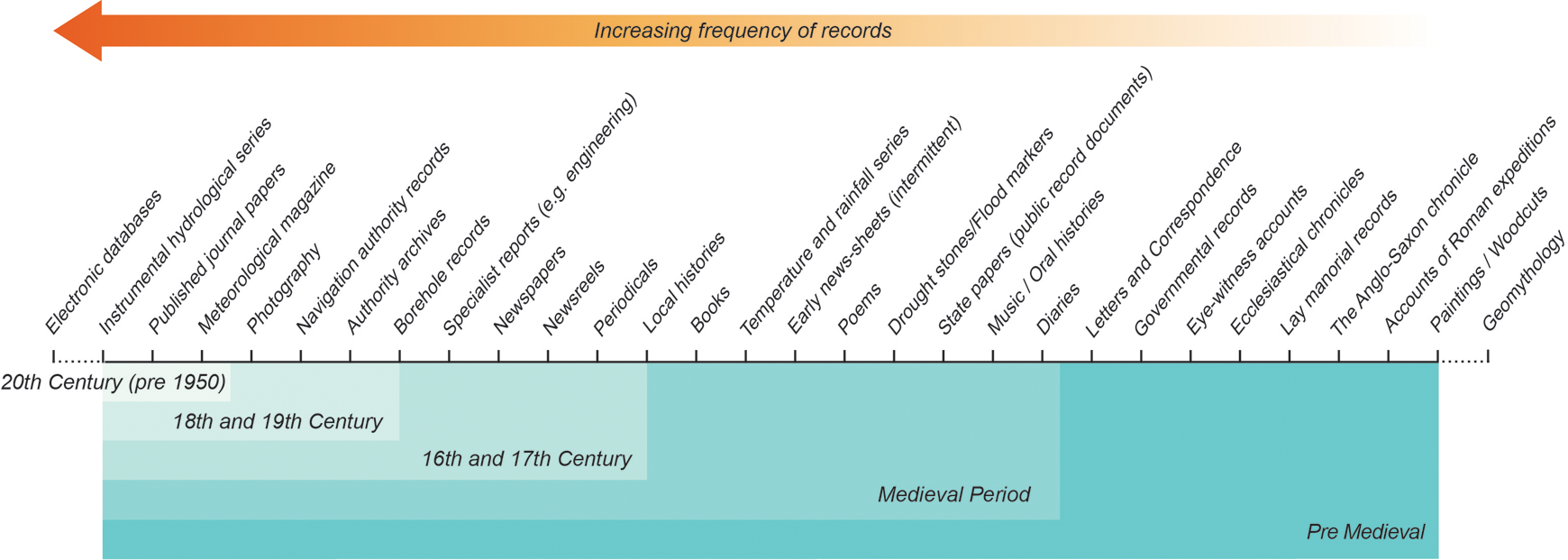
Availability of common source materials.
The location of early historical accounts detailing extreme or notable geophysical, hydrological or meteorological events is subject to recorder presence. Whilst some events can be witnessed directly or indirectly (e.g. the direct observations of the Laki Fissure eruption of 1783–84 by Jón Steingrímsson (1998) in Iceland and the observations of spectacular sunsets created by the same eruptions by Benjamin Franklin (Franklin, 1785) in Manchester, UK), other events are much more specific to locale. As such, the presence of literate individuals is critical, with potentially many extreme events going unrecorded even within recent centuries and now known based on physical evidence alone. The required presence of literate individuals has inevitably lead to greater prevalence in source materials in urban areas, religious centres, places of learning, royal palaces and landed estates (Brázdil et al., 1999; Macdonald et al., 2006). In examining historic events, consideration needs to be given to the language used, the context within which terms of reference are applied and the social and cultural context of events, with each account shaped by the local historical and intellectual environment (Butzer, 2012; Hannaford and Nash, 2016; Schenk, 2014). The use and application of phrases and terms may change through time – with greater use of a certain phrase or words during different time periods, as evidenced by the reduced use of ‘inundation’ in describing flood events nearing the present, and the changed nuance of ‘gale’ historically when compared to today (Naylor, 2015).
The practice of comparing a recent event with previous events, termed here as ‘benchmarking’, is common within many historical accounts. Events may even be benchmarked to those not experienced by the individual involved, with a severe event’s influence far reaching (e.g. the Lisbon earthquake of 1755) and shaping the understanding of the environment, philosophy, epistemology, literature and the arts more widely (Chester, 2001). The extent of this is seen in the expressions of cause for a relatively small landslide at Buildwas in western England in 1773, in which the local pastor, the Reverend John Fletcher, ascribed a landslip to an earthquake. He made reference to the landscape resembling that of the lava fields of Mount Vesuvius, in Italy, which he had previously visited, and made further references to earthquakes in both London (1750) and Lisbon (1755) (Fletcher, 1773). Comparable descriptions are frequently seen within flood records, for example: The incessant rains on Sunday Monday Tuesday and Wednesday in the last week occasioned so greater flood on our river as has never been but once exceeded in the memory of the oldest inhabitants which was in the year 1722 when it is said to have risen eight inches higher. (
Middlesex Journal and Evening Advertiser, 1774)
The growth of photographic materials and newspapers in the 19th century also witnesses the development of, and plays an important role in, the expansion of behavioural practices such as thanatourism (dark tourism; Godbey, 2006). Such excursionists are recorded to have visited the locations of geophysical events, for example Mount Etna in 1809 (Anon, 1809) and after the 1906 San Francisco earthquake (Lawson and Reid, 1908); hydrological events, for example the 1889 Johnstown flood; and meteorological events, for example the 1900 Galveston hurricane (Godbey, 2006). Motives for the gathering of people at sites of death and disaster are numerous, often thought to be negative and said to include, among other elements, curiosity about death and dying (Yuill, 2003). Alternatively, a more recent proposal is that thanatourism may contribute to society’s resilience in both the short and long term by accelerating the healing process, giving a reason to live and lessons to learn (Korstanje and Clayton, 2012). It is notable that dark tourism is usually framed in relation to war and political violence, and rarely in relation to geophysical or other hazards. Pompeii nominally attracts visitors as a result of the excellent preservation of everyday life in a Roman town, but actually it is the allure of the macabre, as illustrated in exhibitions (e.g. ‘Life and Death Pompeii and Herculaneum’ at the British Museum, 28 March–29 September 2013).
Pictorial images can provide valuable information on past events, in photographic, engraved (including woodcuts) and painted forms. Studies have previously used paintings to better understand the extent and damage caused by flooding (Camuffo and Sturaro, 2004), the type and style of volcanic eruption (Nomade et al., 2016) and to understand air pollution (Thornes, 2008). Although useful in confirming the occurrence of an event, the scientific information that can be extracted from early depictions is often relatively limited, though when coupled with documentary accounts this may prove valuable (McGuire et al., 2004). Many early paintings depict factually incorrect representations of natural hazards, with many including religious connotations associated with hell (Kozák and Cermák, 2010: 13), or may equally simply ‘reflect the aesthetic sensibility of the artist’ (Chester and Duncan, 2008: 203; Juneja and Schenk, 2014).
Whilst photographic evidence is regularly used to monitor and provide rapid feedback in contemporary hazard assessment, historical photographic materials have helped document and support other archival sources, often providing valuable illustrative information on the extent and severity of events, for example the Los Angeles earthquake of 1906 (Dean, 1993) and the floods of the River Seine through Paris in 1910 (Attal, 2015), both well documented as a result of early aerial photography. Old photographs also recall past practices and behaviour, both memorable (such as the use of flood memorials for sites of remembrance and grieving (McEwen et al., 2012), a behaviour no longer actively practised) and mundane (the actions of people going about their everyday lives). The role of imagery in early publications was important; as Kozák and Cermák (2010: 7) note, ‘a substantial part of the consumers of this printed output was still illiterate’, with imagery offering an opportunity to convey ideas and meaning (e.g. woodcut illustrations).
In examining source materials, each source requires careful consideration, as the reliability of a source is critical to determining the value and trust which may be placed in it, with concerns raised in the accountability and rigor of historic sources where references to original sources are not made (e.g. Britton, 1937). McEwen (1987) identifies historical sources as those that are authentic and those that are of variable reliability. This provides a binary classification, but, in reality, the reliability of historical sources is difficult to determine, with reliability being measured on a sliding scale from a perceived high to a low reliability. As such, historical source reliability is in part determined by the experience and judgement of the practitioner. The degree of confidence or uncertainty, which is based on methods of data selection, is subject to accessibility and continuity of the records, reliability of the sources and objectivity of the information. In each case, the practitioner needs to be aware of the limits of the data (Macdonald, 2004). Increasingly, these uncertainties are being attributed uncertainty values, and these are embedded into the results either statistically, graphically or textually (e.g. Macdonald et al., 2014). This understanding of the source materials is imperative for good archival practice, as outlined by Gagen et al. (2007) among others.
III Moving beyond the sources
The development of historical geography within the academic literature has evolved predominantly within historical social and cultural fields (see Baker and Billinge, 1982; Gagen et al., 2007), with much discussion on the methodologies and ethics employed (Moore, 2009) coupled to broader discipline evolution in cultural geography understanding (see Lorimer, 2010), and much work undertaken by the individual. Within the physical sciences, the development and use of historical sources in the geophysical, hydrological and meteorological fields has focused upon particular events and locations rather than methodological frameworks, which presents some interesting questions. Methodological evolution has focused more on developing technologies, e.g. digitisation (Hooke and Kain, 1982), rather than broader disciplinary developments. The use of comparative historical research methods in examining the past has been considered as ‘natural experiments of history’ (Diamond and Robinson, 2010). This permits the researcher to explore how an event shaped a society, and the subsequent responses, at a variety of scales. These ‘social laboratories’ in effect serve as an artificial present, from which we can investigate the affected communities’ past and future, and hence potentially discover causal relations. Whilst the analysis of historical materials increasingly occurs through the development of collaborative teams (including anthropologists, archaeologists, geographers, geologists, historians, hydrologists and sociologists, to name but a few) as well as through individual research in the physical sciences, in many cases these teams, when tackling large multinational events (e.g. the effects of the 1540 European mega-drought; Wetter et al., 2014), have blended skills and experiences from across traditional disciplinary boundaries, becoming truly interdisciplinary in nature. The methodological frameworks that have developed offer new ways of exploring these same events (Endfield, 2007), with recent calls to explore not the biophysical events themselves, but their impacts on individuals and communities. As Pfister and Brázdil (2006: 126) state, ‘it would be worthwhile to illustrate the plurality of human responses and solutions in mitigating social vulnerability to climate variability’. This call is reflected within the disaster management arena – Bankoff (2004: 35) calls for greater attention to be given to ‘people who live with the daily threat of disaster [who] have frequently evolved certain strategies or coping practices for dealing with their effects that are quite successful’ – and in the historical hydrology field, ‘in assessing the impacts, the vulnerability of individuals and communities is as important as the relative magnitude’ (McEwen and Werritty, 2007: 78). Through combining methodologies from the humanities with the social and natural sciences, we increase the possibility of identifying analogies between historical conditions and those of the present and future. As Pfister (2009: 240) notes: ‘the importance of historical research results lies in the fact that it can bring together the myriad of experiences gained with respect to certain questions, present them to society as communication about risks or stimulus for reflection and, in doing, make the unthinkable thinkable.’
IV Emerging databases and citizen science
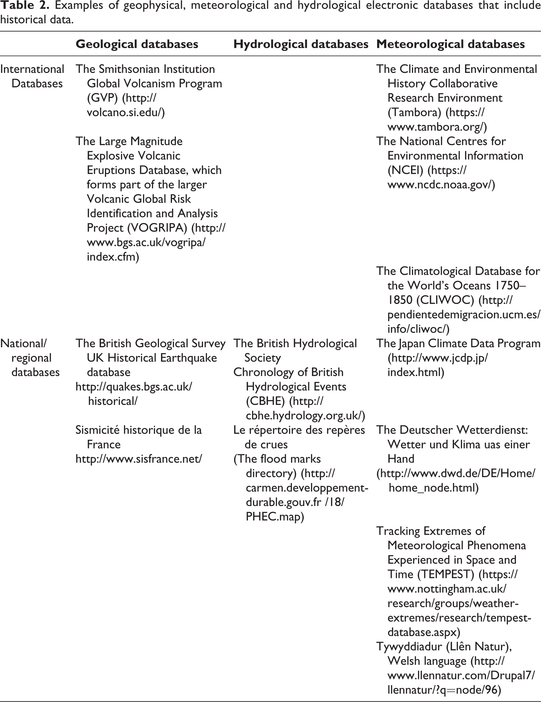
In the past decade, historical natural hazard research has been facilitated by a revolution in the availability of source materials across a range of languages and in a variety of formats, enabled by technological developments in the digitisation and transcription of source materials and resulting in the growth of online resources and databases (Allan et al., 2016). The proliferation of such databases without a single unifying framework has resulted in a number of different structures and practices being employed (Veale et al., 2017b). The development of so many databases (Table 2) reflects increasing interest in historical documents as a source within both the academic community and local communities. The spatial and temporal characteristics of each database reflect the intention of the individual(s) responsible for its construction. In the geophysical field, volcanic and seismic databases tend to be of an international focus (Wood et al., 2015), though landslide databases are often nationally orientated (Van Den Eeckhaut and Hervás, 2012); in the hydrological field, databases are often nationally focused; whereas meteorological databases are presented at regional, national and international levels. This spatial variability within each discipline reflects both the interests of the compiler and the funding streams supporting the database development. In considering some of the examples presented in Table 2, the compiler(s) of these databases vary; the geophysical databases (often international) are often multinational teams, the hydrological databases are often produced by national societies/bodies and meteorological databases are produced by a variety of individuals, societies, projects and communities. In considering the temporal range of the databases across the disciplines, it can be seen to vary, with data collated from across the spectrum of interests: from volcanic records extending back thousands of years (e.g. The Smithsonian Institution Global Volcanism Program) to databases focused on relatively short temporal scales (e.g. The Climatological Database for the World’s Oceans 1750–1850). Notably few of these databases have intentionally directly chronicled the societies affected (although some have indirectly done so), with the original purpose of many of them having been to document the severity or magnitude of past events. This is a significant omission in knowledge surrounding past events, but the situation is starting to change with the creation of some databases that record the societal impact of events alongside the physical characteristics (e.g. the Chronology of British Hydrological Events (CBHE); Black and Law, 2004), whilst others have taken this a step further and more actively focused on recording the societal aspects (e.g. the Tracking Extremes of Meteorological Phenomena Experienced in Space and Time (TEMPEST); Veale et al., 2017b). Chester et al. (2017) provide an excellent review in the geophysical field of the evolution of volcanic databases. A limited number of databases, however, have resulted from the use of a specific or particular data source; for example, within the meteorological sciences, considerable value has been identified within ship logbooks (Wheeler, 2014; Wilkinson et al., 2011), with the original archival research (García-Herrera et al., 2005) expanding to use citizen science approaches (transcription projects focused on data rich sources undertaken by non-experts) as a result of the scale of the task faced (Brohan et al., 2009). The development and expansion of citizen science for transcription purposes during this period has been facilitated by technological developments overcoming some of the costly aspects of data entry historically associated with large data collection projects (Follett and Strezov, 2015). As Kullenberg and Kasperowski (2016) note, the use of citizen science in mapping geographical data is one of the key areas of growth. To date, the use of citizen science in the transcription of digitised sources within the hydrological and geophysical fields is limited, or non-existent. Coen (2013) makes the important point that the development of scientific instruments led to the abandonment of what we now consider citizen science during the early 21st century, and it is only now that we are returning to it and recognising the value of such knowledge.
Examples of geophysical, meteorological and hydrological electronic databases that include historical data.
In considering new databases, it is worth noting that several significant catalogues and/or archives were created before electronic means became available. Archival catalogues have traditionally been framed by the historiographical discipline, being inevitably a subjective exercise; however, with the increasing emergence of historical analysis by non-traditional archival communities, national and local archives may potentially need to re-think cataloguing approaches, enabling their facilitation by a wider academic community and permitting the development of new tools for connecting narratives (Veale et al., 2017a). In developing new databases, existing archived resources need consideration, with future work needed in reviewing their importance and value and how these valuable sources may be digitised and made more widely available.
V Discussion
The use of historical source materials is not limited to just the three disciplines discussed, but these have become three of the more developed fields. Notably, Westermann and Rohr (2015) discuss the use of historical materials in understanding earthquakes and floods, though we feel considerable development also includes volcanoes (e.g. Chester et al., 2015) and droughts (e.g. Wetter et al., 2014), and there is recent increased interest in storms and meteorological fields (de Kraker, 2013). Other examples also include geomorphology (Trimble, 2008) and glaciology (Diolaiuti et al., 2011). To date, the focus of each discipline and its use and application of historical information has been comparable, but also differed. Each discipline has initially used historical sources in an attempt to better understand the frequency of past events, but then to understand the human impacts to some degree. In the latter, some disciplines have developed further and more rapidly than others, but, in each, historical research is now considered a forward looking exercise (Schenk, 2007). This evolution within the different disciplines has resulted in varying methodological and theoretical approaches when considering the use of historical data. In considering whether a best-practice approach can be untangled from the different historical analysis techniques and applications undertaken within the disciplines, it is worth noting that, as Glade et al. (2001) recognised, each has progressed in particular areas, potentially reflecting suitability and disciplinary characteristics.
The use and application of historical records within the geophysical field has probably received the greatest recognition, with much greater focus given to examining human responses (see Table 1). As such, information of this nature is expected in disaster management planning for earthquakes and volcanic eruptions, though less common when considering landslides (see Tables 1 and 2). This level of embedded application has not yet been reached within the hydrological and meteorological fields. Whilst recognition is increasing, few countries yet require or recommend the use of historical information relating to flooding (Kjeldsen et al., 2014). Similarly, past drought experiences are increasingly being recognised as valuable within regulatory frameworks (Wilhite et al., 2014) as relatively short instrumental series often fail to illustrate drought risk adequately for risk management purposes, as such re-analysis of historical droughts can be used to help determine both drought characteristics (frequency and magnitude) to better inform current and future drought mitigation (Lennard et al., 2015). This shift in recognition is in part driven by a need for more information in understanding and managing extreme event risk, coupled with greater acceptance of non-specialist knowledge (e.g. community, non-expert knowledge), though it should exist alongside and not instead of expertise and academic understanding. The cultural heritage collected from historical records permits reconstruction of past knowledge, (re)informing communities and shaping their capacity to deal with future events (Cashman and Cronin, 2008). In considering historical data in natural hazard assessments, it may be helpful to identify thresholds whereby a community is no longer able to survive or cope with a hazard, as such embedding historical knowledge into the typology created by Burton et al. (1993), which introduced four characteristic responses to a hazard: ‘absorption’, ‘acceptance’ or ‘reduction’ of the impact, beyond which a society will need to ‘change’ their use of an area or environment. As Riede (2014) notes where repose times between events (high magnitude) are often long, historical records can strengthen the social resilience that emerges from coupling traditional and scientific knowledge and methods by extending the number of potential case studies that may be used. This framework of increasing recognition of social and cultural understanding of events challenges perceptions of understanding, because recognition that past practices and techniques may continue to have value in current and future successful extreme event management becomes more embedded into current policies and frameworks. Historical analysis has to date predominantly focused on extremes, though mundane (everyday) conditions and societal responses to the mundane are gaining increased recognition (Pfister, 2009). Future historical analysis needs to understand how daily practices have shaped societal vulnerability, with actions both increasing and decreasing overall vulnerability and influencing adaptability.
Recent recognition of the value of historical source materials beyond the traditional historical field has seen a growth in data rescue, both nationally and internationally (Williamson, 2016), with an increasing appreciation of the value of historical data when looking beyond the confines of regions with good instrumental data (Macdonald et al., 2010). Historical sources are seen as a mechanism for better understanding magnitude and frequency relationships, but also community and societal responses in areas where little instrumental data exists (Nash et al., 2015; Van Bavel and Curtis, 2016). The importance of such information is also increasingly recognised when considering recent questions of stationarity within relatively short instrumental data (Milly et al., 2002, 2008, 2015), with historical records often representing periods covering differing climatic conditions during the last millennia, incorporating extremes often absent within the short instrumental series but present within historical series (Brázdil et al., 2012; Macdonald and Sangster, 2017). Hence, historical records permit a more informed understanding of event rarity. Parts of the broader environmental discipline have started to coalesce to address the issue of disaster reduction and climate change (Izdebski et al., 2016), recognising the efforts being replicated across disciplines (Thomalla et al., 2006); although issues such as language, methodologies and politics continue to present barriers. Historical sources are increasingly seen in all three disciplines as a tool for validating the feasibility of contemporary extremes and for comparative dating/complimenting proxy series. Recent examples include flood sequences in lakes (Schillereff et al., 2016), instead of tephra dating (Larsen et al., 2014), intense precipitation events (Miller et al., 2013) and droughts within dendrochronological series (Linderholm and Molin, 2005). The absence of a unifying approach to database design and structure limits the potential of existing databases as it prevents comparison of content and therefore analysis to other series/regions/datasets, for example agricultural data (Campbell, 2010). An emerging area where historical analysis may provide a valuable contribution can be seen in the developing field of multi-hazard analysis, where both perceived direct and indirect hazards are assessed beyond the constraints of an annular timeframe (Hillier et al., 2015) and for which long series are particularly valuable.
VI Conclusions: Learning from the past
Historical data reaches across the traditional interdisciplinary divide, bringing together scholars from a variety of disciplines including anthropology, archaeology, English, geography, geology, history, psychology, sociology and the health sciences. Historically informed, evidence-based knowledge of hazards and their impact on societies presents an opportunity to review contemporary understanding and perceptions of risk, in effect challenging our perception that present methods are ‘better’ and that past techniques and practices have little value in present or future successful responses to natural disasters. Through embedding non-expert knowledge into vulnerability analysis and policies, whilst recognising and embracing the uniqueness of place, management and mitigation approaches can be strengthened, becoming community led (i.e. ‘bottom-up’ rather than ‘top-down’). Historical records often show us how societies have not only been resilient in the past to extreme events but have also continued to develop, therefore highlighting that there are, or have been, coping mechanisms present that at some level are, or have been, effective. However, these mechanisms may be hidden in locations where perhaps an event has not taken place for a prolonged period of time. This hidden knowledge may contain important pieces of information that would otherwise be missed from future mitigation strategies without the engagement of local communities. These ‘incultured’ responses may also become challenged as communities become more mobile (inward/outward migration) and local knowledge is lost (or ignored by new residents/communities); as such, more economically developed regions (greater mobility and lower residency times) may face as great a challenge in maintaining such knowledge as communities in less economically developed regions. Whilst some disciplines, particularly the geophysical, have embraced such understanding, especially on an international scale, this has been slower to be enacted across other disciplines – with few countries yet to require historical analysis of flood risk (Kjeldsen et al., 2014) or drought risk (Estrela and Vargas, 2012) in management or planning, and, where these have been required, actions often simplistically undertaken with limited consideration of how societies have adapted to past events, other than avoidance. Within the meteorological discipline, analysis has focused on reviewing extremes, particularly to early instrumental series (Rodda et al., 2009), but until recently there has been limited analysis of non-instrumental information, with limited consideration of how such information has shaped societal behaviour in management policies or planning. Therefore, both meteorological and hydrological disciplines could benefit from exploring how the geophysical disciplines have embedded ‘incultured’ knowledge into hazard assessment and planning (Hyogo Framework for Action 2005–2015; United Nations, 2015), though it is worth noting that Gilbert White (1945) was making this same call over 70 years ago in relation to flood risk (Macdonald et al., 2012). This may reflect the engagement with the vulnerability paradigm of the international policymaker (Gaillard and Mercer, 2013), but not those at the local or regional level (often where hydrological and meteorological policy is applied), exhibiting the different scales at which natural disasters may be managed (Donovan, 2017).
Despite the challenges in using historical sources across the disciplines, they have each shown that there is significant value within and increasingly across disciplines, with new research avenues and applications being identified that help to shape and improve understanding of future societal vulnerability and adaptations. In looking across the disciplines, it has become evident that whilst coevolving, they have each also responded to disciplinary needs and may in places be converging (e.g. databases); but, by looking across the disciplines, lessons can be learned and opportunities identified for future consideration.
Footnotes
Acknowledgements
Two anonymous reviewers are thanked for suggesting improvements to the manuscript.
Declaration of Conflicting Interests
The authors declared no potential conflicts of interest with respect to the research, authorship and/or publication of this article.
Funding
The authors received no financial support for the research, authorship and/or publication of this article.