
Abstract
Rainfall arrival at the land surface drives or influences many geomorphic processes. These range from the mechanisms through which vegetation transforms rain into erosive gravity drops or stemflow, infiltration and water partitioning at the soil surface, the drop-impact sealing of soil surfaces, splash, sheet, and gully erosion, and triggering of the various forms of mass movement including landslides and debris flows. Rainfall intensity is a key influence on many of these mechanisms but is not a straightforward parameter to quantify, partly owing to the customary aggregation of rainfall data to hourly or other clock-time totals. This aggregation conceals intensity fluctuations including erosive ‘intensity bursts’ as well as the intermittency of rainfall. Nevertheless, much research shows that rainfall intensity over short time periods – 10–30 minutes – has great explanatory power. Much of our understanding of the influence of rainfall intensity is based on rainfall simulation experiments, but the value of the findings is limited because simulation is normally carried out using a high and constant rainfall intensity, quite unlike natural rainfall. This has limited our ability to build an understanding of the other important aspects of rainfall intensity, including, critically, its time variation and changed character among different environments – arid, temperate, or tropical. Thus, significant challenges and opportunities remain in the exploration of rainfall intensity in relation to geomorphology and geomorphic processes.
Keywords
I Introduction
The operation of the hydrologic cycle exerts a fundamental influence on the geomorphology (and many other aspects) of the global land surface. Beyond the areas where precipitation is snow-dominated, rainfall is a key driver of many surface processes on hillslopes and consequently in the development of the networks of stream and river channels that drain the landscape. Evaporation from the oceans is essentially a continuous process, removing on average ∼ 1.2m from the oceans per year (Bengtsson, 2010; Trenberth et al., 2007). Part of this is advected over the land, but the rainfall that results there is highly discontinuous in its arrival. The net flux of vapour from the oceans to the land (about 38 × 103 km3 a –1) would yield a mean precipitation depth over the global land of 250mm a –1. However, much of the precipitated water is returned to the atmosphere over land and falls again, yielding a total flux of 109 × 103 km3 a –1. This equates to a mean annual precipitation of 730mm, or 2mm d –1, in turn the equivalent of a mean intensity of 0.08mm h –1. Common experience confirms that, in fact, raining time can be either of very low intensity such as this, but commonly much more intense. As a result of diverse factors that control intensity and rainfall occurrence, rainfall arrival involves rainless periods of widely varying duration that separate storms or showers (‘rainfall events’). These can range in character from light drizzle of 0.1mm h –1 to torrential downpours of more than 100mm h –1, with intensity thus spanning more than four orders of magnitude. However, in most environments, rain most frequently arrives in small falls of low intensity (Figure 1) and less often in very intense events, though the latter can contribute much of the annual total rainfall.
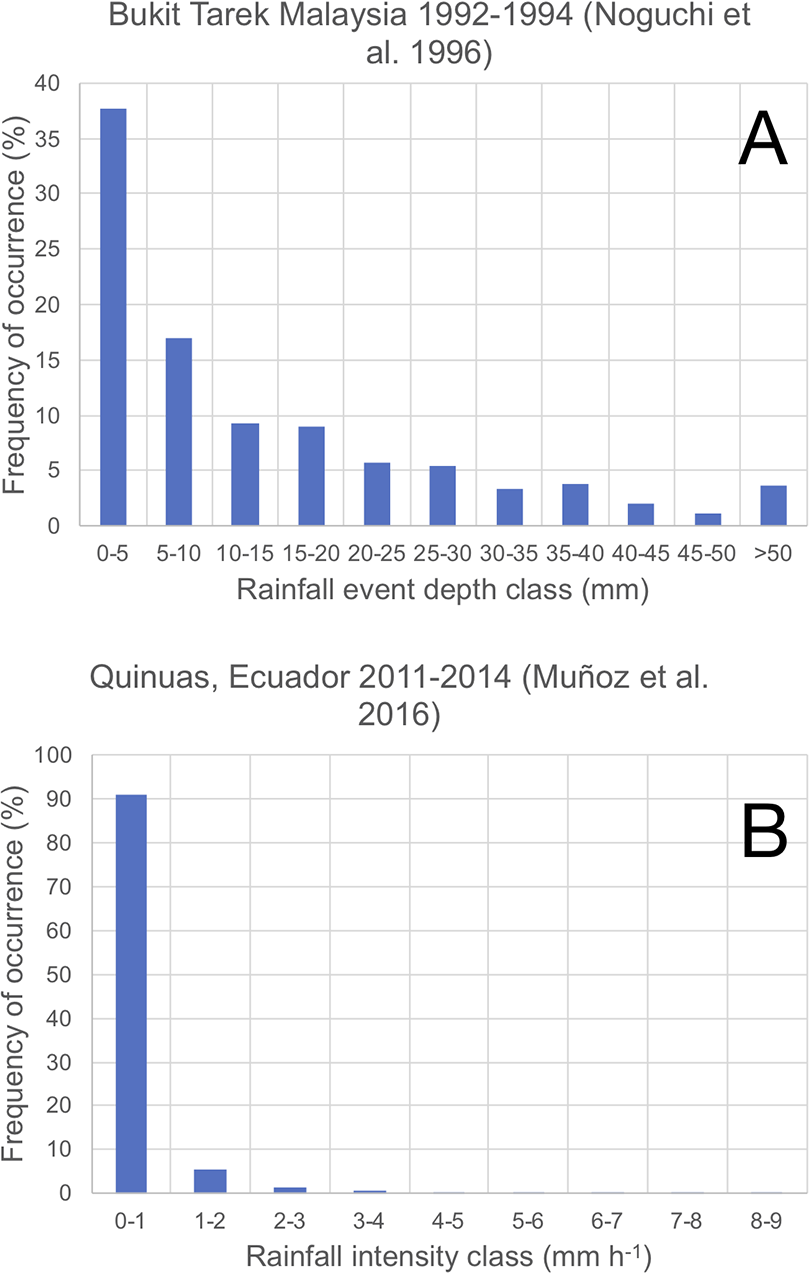
Data showing that the highest frequency of occurrence of rainfall is in the form of small events delivering depths of < 5mm (A) and events of low intensity, typically < 2mm h –1 (B). Comparable rainfall arrival data typify many locations globally.
Key characteristics that are commonly considered in the analyses of rainfall arrival include the amount of rainfall at a place, the frequency with which it rains there, and the intensity or rainfall amount delivered per unit of time when it is raining. These characteristics, and others such as the drop sizes involved, the erosivity of the rain, or the solute concentration, exhibit important temporal variability, including diurnal cycles and seasonal or annual cycles. Many are relevant to understanding geomorphic processes. Some of the effects of rainfall arrival are mediated by the effects of rainfall on other land surface features such as seasonally changing vegetation cover, or antecedent soil wetness or dryness prior to a rainfall event, as well as by seasonal climates themselves, influencing for instance evapotranspiration rates and surface drying. These interactions are not fully known. They can be illustrated by the modelling study of Takahashi and Polcher (2019), who showed that regionally, existing soil moisture can affect the arrival of rainfall. Moist surfaces partition more of the incident radiation at the ground into latent energy rather than sensible heat; this reduces the vigour of convection (and hence uplift and moisture convergence) and so rainfall intensity tends to decline. Over drier surfaces, the reverse occurs. Interactions of this kind between the land surface and the hydrologic cycle have been widely documented (Dickinson, 1995; Lyons, 2002; Lyons et al., 1993) and provide one of many pathways through which human activity affects the hydrologic cycle.
Indeed, it is necessary to acknowledge the almost ubiquitous role of human modification of the hydrologic cycle, which has effects on rainfall arrival. These go well beyond the widely investigated role of anthropogenic climate change and possible invigoration of the hydrological cycle (Myhre et al., 2019). For instance, de Vrese et al. (2016) explored the role of irrigation in increasing moisture availability at the land surface. The convection-suppressing role of moist surfaces was touched upon above. de Vrese et al. (2016) showed that in some dry regions of East Africa up to 40% of the rain is in fact related to moisture derived from irrigated agriculture in Asia. Human influence on the hydrologic cycle and on rainfall arrival is thus pervasive.
A number of other variables influence the nature of rainfall arrival geographically. The mechanisms generating the rainfall are among the most important. Convective storms (Purr et al., 2019), for instance, can be intense but relatively short-lived (from the Dead Sea region, Belachsen et al. (2017) reported a mean convective cell lifetime of 18.1 minutes); orographic rainfall resulting from persistent onshore winds may in contrast be of low intensity but much longer duration (Dairaku et al., 2014). This complicates the analysis of geomorphic impacts because both forms of rainfall can result in erosive events but via different mechanisms. Kirkbride and Reeves (1993), for instance, documented extensive rill incision in Scotland resulting from rain whose intensity rarely exceeded 4mm h –1, a very moderate intensity, but which persisted sufficiently long to result in saturation overland flow. Alexandrov et al. (2007) showed that high-intensity and low-intensity rainfalls resulted in approximately tenfold differences in suspended sediment concentration and differing hysteresis behaviour in Nahal Eshtemoa in Israel, and pointed out that, via these mechanisms, different kinds of rainfall arrival could contribute to wide scatter in sediment rating curves.
A characteristic of rainfall of particular significance to geomorphic processes is its intensity, and this forms the subject of the present review. Rainfall intensity exhibits marked spatio-temporal variability; the more than four orders of magnitude range of intensities makes the observation and recording of rainfall challenging, especially towards the extremes of the distribution, including problems connected with the recording apparatus itself. Commonly, rain gauges have a collecting funnel delivering rainwater to a tipping-bucket mechanism (or in some cases to a weighing system or drop-counter). Evaporation from the funnel in rain of very low intensity can result in no rain being recorded at all, regardless of the kind of mechanism that is used within the gauging apparatus itself, such as a drop-counting system. On the other hand, in very intense rain, there can be significant dynamic under-catch owing to the finite time taken for the bucket mechanism to tip. This error can reach 20% at 230mm h –1 (Shedekar et al., 2009). There are also problems in defining intensity from rain gauge data, even ignoring observational errors. For instance, hourly totals are commonly the finest time resolution available in government rainfall records, though much finer resolution is locally available. The problem with time-aggregated data is that intensity I (mm h –1) is estimated from the relation:

where P is the total rainfall (mm) recorded during the accumulation duration (AD), for example an hour. However, in fact a better (less biased) estimate of intensity would be given by:

where T is the total time (h) during which rain actually fell.
Thus, if 5mm of rain was recorded in an hour, use of equation (1) would suggest a mean intensity of 5mm h –1. However, if the rain actually fell in just 30 minutes, and we somehow knew that (impossible from hourly AD data), then the intensity would be better estimated from equation (2) as 10mm h –1, an increase of 100%. This simple example shows that rain gauges commonly only record P correctly; they do not record T and therefore most intensity data are estimated using some arbitrary AD as in equation (1) rather than the unknown T needed in equation (2). Intensity estimates can carry very significant bias as a result. There are ways in which true raining time (and hence intensity) can be recorded with much less bias, including acoustic methods that record the presence or absence of the sound produced by raindrop impact on a resonant surface (Dunkerley, 2020a) and thus allow T to be reliably identified, but these are not in common use.
The loss of intensity data that occurs when tipping-bucket data are aggregated to convenient ADs (equation (1) such as 30 minutes or one hour can be reduced if the unaggregated inter-tip times are analysed instead. This proceeds on the assumption that the rainfall intensity does not alter during the time taken to fill each bucket. Then:

where R is the rainfall rate (mm h –1) between times T 1 and T 2, the clock times of two successive bucket tip events (hour), and ▵V is the recorded rain depth (mm) that is a function of the bucket capacity, which is typically 0.2mm. The application of unaggregated inter-tip times was illustrated by Dunkerley (2019a).
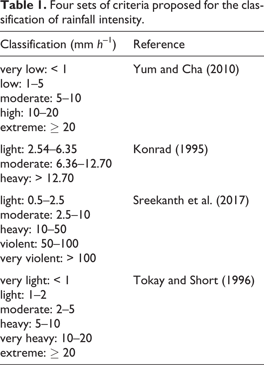
It is important, therefore, when interpreting or using rainfall intensity data, to understand how they were derived and what level of bias may be present. The bias generally increases with the AD; daily data, for instance, carry little actual intensity information, despite the widespread use of the Simple Daily Intensity Index (SDII) in studies of secular climate change (Giorgi et al., 2019; Wang et al., 2019). Bearing these caveats in mind, some classifications of rainfall intensity are listed in Table 1.
Four sets of criteria proposed for the classification of rainfall intensity.
A final point that will emerge as important in what follows is that data suitable for use with equations (1) or (2) are most often derived from a ground station where point rainfall data are collected. However, for the geomorphologist, important rainfall data often come not from a research site itself, but rather from the nearest government weather station or a research weather station a few hundred metres away from some experimental site. Thus a further source of uncertainty in intensity data is how well data collected some distance away reflect the intensity where it matters: perhaps at the centre of a large agricultural field where sheet erosion is a problem, or across a mountain catchment where research is seeking to understand the controls on stream sediment loads. In such cases, remote-sensing methods such as radar may yield quite a different estimate of the mean areal intensity, and one which may well be of greater relevance to spatially extensive phenomena such as overland flow and water erosion in a stream catchment. However, even these methods require calibration and validation, and this often brings us back to the problems of recording rainfall directly using pluviographs, some of which were touched on above. Dense networks of rain gauges provide another approach to a solution, but involve substantial cost as well as considerable work in establishment, maintenance, data acquisition, and data reduction. Illustrative studies were presented by Nord et al. (2017) using 31 rain gauges in a catchment of 116km2, and by Lebel et al. (1987) who employed 34 gauges in a catchment of 545km2. The Walnut Gulch research watershed in SE Arizona employs 88 gauges across the 149km2 catchment, one of the densest of networks, but this is still less than one gauge per square km. An extensive network of 96 rapid-response and remotely read rain gauges was used by Freeny and Gabbe (1969) in New Jersey, USA. The gauges were set out on a 1.3km grid over an area of < 180km2, and generated 14 million one-minute rainfall readings, thus combining moderately high spatial with high temporal resolution. Networks of disdrometers have also been deployed for areal rain studies (Jameson and Larsen, 2016), but these involve very considerable expense. New methods for recording rainfall intensity are emerging continually, including the collection of data from car windscreen wipers (Bartos et al., 2019), the use of vision from security cameras (Jiang et al., 2019), and from signal attenuation among networks of telephone towers (Polz et al., 2020).
A conclusion that can be drawn from the foregoing is that rainfall intensity is, by itself, a complex characteristic of rainfall arrival, and one that is challenging to record event at point-scale. Hydrologic and geomorphic research may often require catchment-wide estimates of rainfall intensity and its variability, but appropriate data are not readily available. Armed with these few remarks about some of the challenges in deriving unbiased information on rainfall intensity, we turn to the importance of this parameter in geomorphology.
II The significance of rainfall intensity in geomorphology
2.1 Interception, stemflow, and gravity drop erosion
Though rainfall data are collected in the open, over much of the land surface, vegetation partially or wholly covers the soil such that before reaching the soil rain may be intercepted on foliage, bark, and ground litter. Intercepted rainfall can become stemflow, and on plants with high funnelling ratios this can result in runoff from the base of the stem, which can be erosive (Herwitz, 1986, 1993). From wet canopies, gravity drops larger than those of the incident rainfall (Moss and Green, 1987) can fall to the ground, and if they fall from sufficient height they can also trigger soil splash erosion. Many of these processes were reviewed by Dunkerley (2020c). All are dependent on rainfall intensity (Figure 2), since in more intense rain a larger proportion of rain can be splashed from the plant canopy rather than retained (Dunkerley 2014); leaf droop owing to the weight of intercepted water also releases drops more readily. However, because canopy drip can transform the small drops of drizzle or light rain into larger gravity drops of up to 6mm diameter, interception processes can diminish the differences in splash impact that might be expected between drizzle and more intense rainfall. Indeed, given that mist and fog droplets can be caught on foliage and converted to large gravity drops, these canopy effects probably result in more frequent sub-canopy splash erosion from light rain than from intense rain, which occurs less frequently. This kind of ‘smearing’ or blurring of the effects of wide-ranging rainfall intensities arises in other geomorphic contexts, as will be shown below.
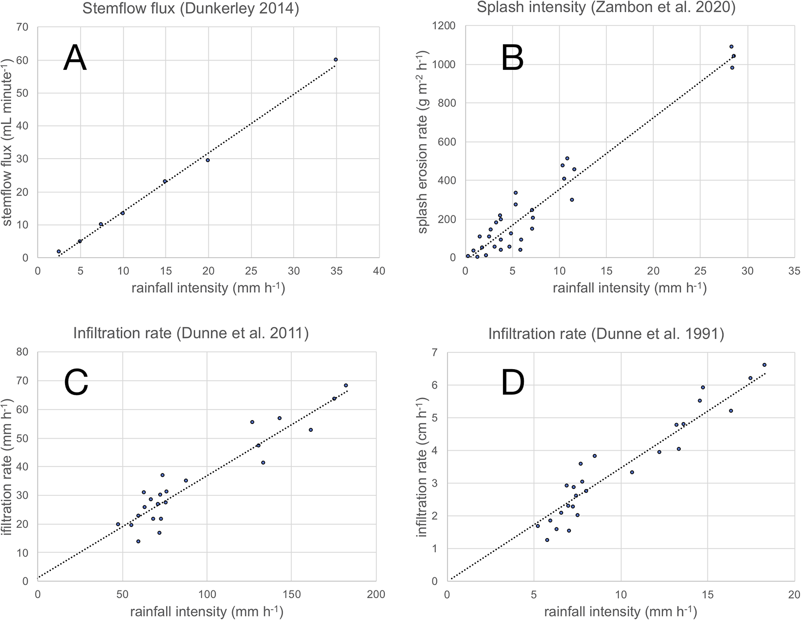
Illustrations of the relationship between rainfall intensity and various land surface processes: stemflow flux (A), soil splash intensity (B), and infiltration rate (C, D). In each case, best-fit linear regression relationships are shown by the dotted line.
2.2 Water partitioning and infiltration at the soil surface
Rainfall intensity is one of the principal determinants of water partitioning at the soil surface. Low-intensity rain may be readily absorbed until rainfall ends or until saturation occurs, whilst high-intensity rain may quickly exceed the soil infiltrability, resulting in surface ponding and integrated downslope overland flow. Though it is frequently analysed in theoretical approaches as though it were a function of the soil matric viewed as a porous medium, water partitioning and infiltration at the surface are indeed intensity-dependent; that is, they depend on factors other than the properties of the soil matrix and its pore structure. Several factors contribute to this situation, which is all-too-often overlooked. One is the uneven microtopography of the soil surface, which causes ponding to be localised rather than a uniform film or sheet across the entire surface, and which leaves elevated parts of the surface not inundated. Where there are local ponds infiltration can proceed at its most rapid rate, whilst on prominences only incident rainfall supplies the water, and this may arrive at rates less than the infiltrability. As rainfall intensity increases, the area of ponding increases, and the areal aggregate infiltration rate (as it might be recorded from a bounded runoff plot) rises synchronously. A second explanation can be found in dryland shrub ecosystems, where the shrubs often sit on low mounds composed of in-splashed fine sand. As ponding and overland flow in the shrub interspaces becomes deeper, more of the highly porous shrub mound becomes inundated, and the infiltration rate rises. There are other such effects of microtopography on water partitioning and infiltration, related to the prevalence of surface sealing and crusting, that can be inhibited where ponding is often present during rain. However, depositional crusts can arise in such locations (Valentin and Bresson, 1992; Wu et al., 2016) and the infiltrability of soils, and the infiltration rate during rain, can consequently vary markedly over quite short distances.
The influence of rainfall intensity on infiltration is thus complex and multi-faceted. Ponding on uneven soil surfaces has a role to play (tending to increase infiltration rates under more intense rain – though there are competing effects, touched on below), as does the formation and destruction of surface seals and crusts, whose effect in throttling infiltration may be maximised at some intermediate intensity, before crusts are scoured by fast surface runoff. A mechanism that tends to reduce infiltration rates in more intense rain is the compression of air driven downwards into soil pores under intense rainfall impact, which can result in pressurised, entrapped air (Ma et al., 2011; Wang et al., 1998; Wang et al., 2014). This then closes potential infiltration pathways in the network of soil pore spaces and reduces the infiltration rate, promoting ponding and potentially erosive surface runoff. In this way, the geomorphic impact of intense rainfall may be further boosted by its effects on and within the soil, but in ways that are likely to differ from place to place according to the local soil properties and rainfall characteristics.
Infiltration where air has been entrapped is known to involve less regular downward progression of the wetting front, and a tendency to a more unstable, finger-flow pattern of wetting-front progression (Wang et al., 1998). Wang et al. (2014) showed that according to a modified Green–Ampt model allowing for confined air pressure, the time for a wetting front to progress to a depth of 1m increased from 43 min to 282 min once air pressure effects were incorporated. Similar findings from a soil column experiment were reported by Ma et al. (2011). Infiltration rates can thus be reduced dramatically by air entrapment resulting from intense rain; the geomorphic importance of this of course is that this process increases the partitioning of water into surface ponding and potentially erosive surface runoff, so magnifying the impact of intense rainfall, or the frequency with which overland flow occurs. To the writer’s knowledge, the air entrapment effect has not been incorporated into a hydrologic model at field, hillslope, or catchment scales, and this would be a worthwhile exercise to explore. Indeed, the phenomenon of air entrapment warrants additional research, though this will be a challenging undertaking for field-based experiments.
2.2.1 The importance of rainfall temporal characteristics – intensity profile and intermittency of rainfall
One of the tools used to explore the influence of rainfall intensity on infiltration and water partitioning is rainfall simulation, which is routinely used in both the laboratory, on soil trays, and in the field, on small experimental plots (Kinnell, 2016). In the vast majority of studies, simulated rainfall is applied continuously and at a constant intensity (Boix-Fayos et al., 2006). This is primarily done because the agricultural spray nozzles that are frequently used to generate a spray of droplets require a fixed operating pressure, but also partly because the experimenters are unaware of, or simply do not take account of, the likely bias that this introduces into their results. It is worth observing some of what is missing in rainfall simulations of this kind.
Two characteristics of rainfall that are essentially ubiquitous are routinely overlooked in rainfall simulation experiments: first, that intensity fluctuates during rain, and second, that rain often ceases temporarily for brief or longer periods (this is intra-event intermittency). Both effects contribute to the bias in intensity that results from a reliance on equation (1), especially for long ADs such as one hour.
The first important characteristic of real rainfall arises from the intensity profile (also referred to as ‘storm pattern’). In convective (thunderstorm) rainfall, for instance, uplift from the land surface is commonly promoted by afternoon warmth. However, the onset of rainfall cools the surface; uplift and moisture convergence then wain, and the rainfall intensity declines towards the cessation of rainfall after 30–60 minutes. As is commonly encountered in drylands, this results in an intensity profile where the most intense rainfall occurs early in the event, constituting what can be described as an ‘early-peak’ event. Other intensity profiles, linked to different rainfall mechanisms, involve the peak being shifted within the event, and many events are in fact either ‘central-peak’ or ‘late-peak’ events (Bustami et al., 2012; Yoon et al., 2012). The significance of the intensity profile for soil erosion and geomorphology is that early-peak events are associated with much lower runoff ratios and peak flow rates in overland flow than are late-peak events. In part this is because in late-peak events the soil has already become wet prior to the arrival of the intensity peak; this results in much more of the rain in that peak being partitioned into surface runoff (Figure 3A shows an early-peak event from a wet tropical site in northern Australia). The early-peak events typical of dryland convective storms actually favour infiltration and the recharging of root-zone moisture, which means that the rainfall arrival has ecological importance in addition to its geomorphic significance.
Intermittency of rainfall is a second virtually ubiquitous phenomenon, but one that is almost universally ignored in rainfall simulation experiments. Identifying the degree of intermittency in natural rainfall is a technical challenge, and is prone to very large bias if AD data are used, since intermittency during the AD cannot be detected. The importance of intermittency requires further study, but it is known that during breaks in rainfall, surface ponding may dissipate, and the infiltrability of the soil may partially recover. In this way, when rain begins again, the infiltrability has increased in comparison with the value when the rain ceased.
Limited attempts have been made to study the above effects using rainfall simulation. Studies of intensity profile have generally used very artificial, staircase-like or stepped intensity, with little resemblance to natural rainfall (Figure 3). Examples can be found in the work of Frauenfeld and Truman (2004), Ran et al. (2012), An et al. (2014), Mohamadi and Kavian (2015), Tao et al. (2017), Wang et al. (2017), Fadhel et al. (2018), and Alavinia et al. (2019). The effects of intermittency on runoff and erosion have not been systematically investigated at all. Using rainfall simulation that did involve intermittency, Dunkerley (2018) showed that infiltrability could recover significantly in dryland soils during just a 10-minute rainfall interruption. However, that work dealt only with the effects of rainfall intermittency on water partitioning and infiltration; sediment removal from the experimental plots was not recorded. This is an area that warrants extensive additional research. In particular, the writer is not aware of any experimental studies in which varying intensity profiles, together with varying degrees of intermittency, have been explored, even at plot scale or indeed in the laboratory, despite this being the condition in most natural rainfall.
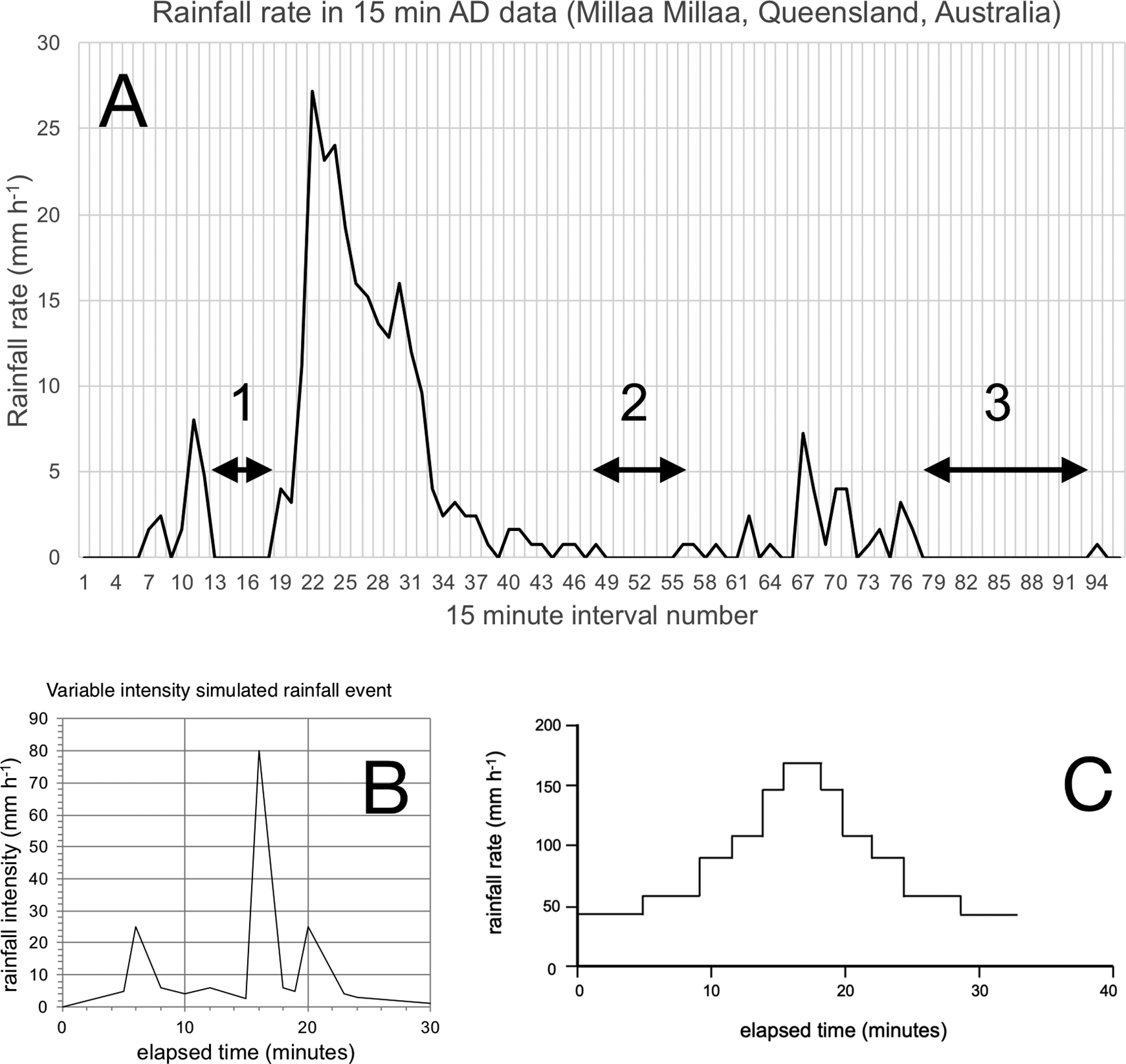
Illustrations of the intensity profiles of natural and simulated rainfall.
2.3 Seal and crust formation
The impact energy expended when raindrops strike a soil surface drives the breakdown of soil aggregates, and splashes both water and sediment particles, the latter being referred to by Moss and Green (1987) as airsplash. This is considered shortly.
A related affect is the change in near-surface soil microstructure that can result from the drop-impact forces. Owing to the bombardment of the soil surface by incident drops, silt, clay, and other fine particles can become aligned and compressed to form a thin crust or seal, virtually impermeable to air and water. As shown long ago by McIntyre (1958), these raindrop impact crusts may be no more than 0.1mm in thickness. Higher rainfall intensities result in greater strength of the resulting crusts (Nciizah and Wakindiki, 2014). Armenise et al. (2018) used rainfall simulation to show a 60% reduction in unsaturated hydraulic conductivity of several UK loam soils from just 2–9 minutes of rainfall. Low crust permeability is important for geomorphology as it promotes more frequent overland flow (potentially erosive), and then perhaps downslope the formation of depositional crusts, which can have similar effects on water partitioning and infiltrability (Morin and Van Winkel, 1996).
2.4 Changing soil surface roughness on tilled agricultural soils
Soil surface roughness, especially on tilled soils, exerts an important influence on the generation of overland flow. Though this could have been discussed in section 2.2 above or section 2.6 below, it is treated separately here because it bears on both infiltration and runoff as well as on erosional processes.
Raindrop impact energy is partly expended in remoulding the surface roughness, especially on agricultural soils where the mounding and roughening effects of tillage can be progressively smoothed during rainfall. Overall frictional retardation of overland flow can in this way be reduced during rainfall, with a corresponding increase in the velocity and erosivity of the runoff. Torri et al. (1999) explored aspects of this phenomenon, in an environment with complex, multi-peaked and intermittent rainfall (Tuscany) (see Figure 1 in Torri et al., 1999).
There are many studies of the decay of surface roughness, especially on tilled soils (Bramorski et al., 2012; Dalla Rosa et al., 2012; Idowu et al., 2002; Römkens et al., 2001; Vermang et al., 2015; Zhao et al., 2018). These studies generally show that runoff rates and concentrations of eroded soil particles in the overland flow increase during rainfall. For example, using loamy soil from Indiana, USA, and artificially created surfaces of varying roughness, Vermang et al. (2015) showed that runoff fluxes (mm h –1) increased from zero or nearly zero on fresh surface roughness to 25–35 mm h –1 after 80mm of accumulated rainfall. Rates of increase in runoff rates were larger under more intense simulated rainfall. In their laboratory soil trays, runoff did not begin until after 10–20mm of rainfall. These findings suggest that after tillage, the amount of runoff and erosion will be a function of both the intensity of the rain and the rainfall duration, together with the antecedent wetness of the soils. In studying the effects of successive rainfalls on surface roughness and the tortuosity of overland flow paths, Bramorski et al. (2012), for instance, showed that most roughness reduction occurred in a first simulated rainfall at 30mm h –1 and considerably less in a second and third rainfall.
2.5 Splash dislodgment and erosion
Some raindrop impact energy can result in splash transport of soil particles. Rainfall intensity is critical to the rate of this process, since the energy delivered to the surface increases with rainfall intensity; moreover, the impact pressure at points struck by incident drops increases non-linearly with intensity because, simultaneously, drop size can increase. Remembering that the kinetic energy of a falling drop is given by 0.5 mv 2, when diameter increases, fall velocity also increases, and impact energy rises steeply. However, a further aspect of rainfall arrival that is often neglected emerges here: the areal drop arrival rate. This specifies the number of droplet impacts per unit area and unit time. Large droplet impacts are generally less frequent than small droplet impacts, according to the size distribution of drops, in turn related to the rainfall intensity (Larsen and O’Dell, 2016).
Studies of splash erosion in relation to rainfall intensity have been made both in the field, using sand- or soil-filled splash cups from which progressive weight loss is recorded, or in the laboratory using either single drop impacts or rainfall simulation (Scholten et al., 2011). These have quantified the masses splashed, the distances through which airsplashed particles are transported, and many other details. Importantly, it is clear that the intensity of splash transport, expressed in units such as kg m –2 s –1, increases with rainfall intensity. Interrill areas cover much of the soil surface, and splash dislodgment by drop impact is the major source of erodible sediment particles that are then carried to rills and proto-channels by overland flow, perhaps itself disturbed by incident drops, except in afterflow.
For both crust formation and splash erosion and transport, possible future changes in rainfall intensity loom as a driver of increased frequency and/or severity of the impacts of intense rainfall. More frequent or more extensive crust formation in coming decades, for instance, and especially on agricultural soils, could be associated with greater erosion than might be anticipated from the change in rainfall intensity alone; furthermore, stronger or more extensive crusts could retard seedling emergence (Nciizah and Wakindiki, 2014) and further exacerbate the risk of erosion, in addition to the retarding of crop growth owing to the combined effects of crust strength and the restricted entry of water into the root zone.
2.6 Sheetwash and overland flow erosion
The aspects of water partitioning, crust development, and the intensity of splash dislodgement and erosion, all influenced strongly by rainfall intensity, feed into overall rates and mechanisms of sheetwash and overland flow erosion on hillslopes and across landscapes, and across the diversity of environments from drylands to agricultural fields to the wet tropics. As noted in the foregoing, there are many studies of individual processes, but relatively few that attempt to relate plot-scale or rainfall simulation experiments to the sediment loads carried by streams. Kinnell (2005, 2020a, 2020b) has explored some of the key interactions of shallow overland flow, drop impacts, and the motion of mobile soil and sediment particles.
2.6.1 Estimating longer-term soil loss rates resulting from sheet erosion
A major and long-standing area of concern for soil scientists, geomorphologists, and others is the estimation of soil loss rates from agricultural land over the longer term (periods of years). Predictive models are routinely used for this, based in part on empirical data from experimental plots, including the universal soil loss equation (USLE), revised universal soil loss equation (RUSLE), water erosion prediction project (WEPP), and many other models and classes of models (Lee et al., 2017; Zerihun et al., 2018). One important influencing factor in RUSLE-type models is the rainfall factor (R), which reflects the mean rainfall intensity and kinetic energy delivered to the soil surface. Rainfall intensity is characterised by I 30, the maximum rainfall amount in a 30-minute period of an erosive rainfall event (Dunkerley, 2010, 2019a). A full discussion of erosion models is beyond the scope of this short review; discussions can be found in references such as Panagos et al. (2015, 2017a, 2017b).
In these models, the erosivity of the rainfall is incorporated by including an estimate of the kinetic energy of the incident rain (E), to form a composite factor, EI 30. The kinetic energy is expressed in units such as J m –2 mm –1, and is estimated from the rainfall intensity using relationships that link greater intensities with larger incident drop sizes. The kinetic energy, which can be expended partly in aggregate breakdown, seal formation, and soil particle splash, rises rapidly with rainfall intensity, to plateau at values of 20–30 J m –2 mm –1 for rainfall intensities greater than about 40–50mm h –1 (Kinnell, 1987). Low-intensity rainfall (at a few mm h –1) would deliver kinetic energy at less than a quarter of this rate. Considerable uncertainty surrounds the correct relationship between rainfall intensity and kinetic energy, and indeed whether momentum might not be a more parsimonious measure than kinetic energy (Goebes et al., 2014); for a recent discussion, see Wilken et al. (2018).
2.7 Debris flows and other mass movements
Much of the foregoing has focussed on the importance of rainfall intensity to the mechanisms of individual particle dislodgment and transport. However, the effects of rainfall intensity extend also to mass movements.
In steep terrain and especially in the post-wildfire period, debris flows are frequently associated with intense rainfall. Moving under laminar flow conditions, debris flows are capable of transporting extremely high sediment concentrations and very large particle sizes, up to boulder size (Iverson, 1997). Cannon et al. (2008) tabulated the rainfall characteristics of storms associated with multiple debris flows in Colorado and California, USA. In both areas, prolonged but low-intensity rainfall was shown to be the cause of many flows. Cannon et al. developed plots of rainfall duration (D, hour) versus the corresponding mean intensity (I, mm h –1), and plotted thresholds above which debris flow had been recorded and below which they had not. The relationships for damaging debris flows were:
I = 6.5D –0.7 and I = 9.5D –0.7 for south-western and south-central Colorado
and
I = 12.5D –0.4 and I = 7.2D –0.4 for the Ventura County and San Bernardino study sites.
Higher rainfall thresholds were found once significant post-fire vegetation recovery had occurred. The Colorado debris flow data for events caused by short but high-intensity rainfalls showed that flows could be triggered by as little as 6–10 minutes of intense rainfall. This stresses the importance of high temporal resolution in rainfall data, such that intensity over such short time periods can be ascertained, certainly << 1 hour being required. Wu et al. (2019) derived a similar duration-intensity threshold for the Sichuan area, China. Paraboloid surfaces have also been fitted to debris flow occurrence data and rainfall characteristics (Chen, 2020, for Taiwan), again suggesting that the triggering rainfall can be achieved either by low-intensity but prolonged rainfall, or higher intensity but shorter duration rainfall. An important issue is how frequently events are triggered by one or the other kind of rainfall, how much material they transport, and, importantly, how much damage they cause to infrastructure downslope.
However, contrasting results have also been reported that cast doubt on the generality of the ‘intensity-duration’ threshold approach. For instance, Yu et al. (2016) reported that high-intensity, short-duration rainfall was the trigger for debris flows in Yunnan Province, China. Their predictive model for debris flow occurrence is based on the maximum 10-minute intensity (I 10) of the rainfall event that triggered the debris flow.
Indeed, the diversity of debris flow environments (steep unburned terrain, post-fire landscapes, and others) suggests that general controls on triggering are unlikely to apply universally. Nevertheless, it is clear that short-term intensities, which are expected to become more frequent under an invigorated hydrologic cycle, may trigger more frequent debris flows in coming decades (Winter et al., 2010). However, a critical issue that was touched on earlier that is important to this area of research is just where the rainfall intensity is measured, and whether the data are sufficient for the intended purpose. Marra et al. (2014) explored the triggering of 117 debris flows in the eastern Italian Alps. In alpine environments, there can be large areal variations in rainfall intensity and amount over small distances, and Marra et al. explore the likely uncertainty in duration-intensity thresholds derived from gauge data versus area-wide radar data. They pointed out that gauges are typically located in the low-lying valley areas, whereas the debris flows are triggered in the steep uplands. Their study area contained 120 rain gauges, and a central doppler radar at an elevation of 1860 metres above sea level. Their conclusions suggest that rain gauges severely underestimate the duration-intensity thresholds. Shi et al. (2018) further explored this effect and highlighted the importance of correct recording of the intensity in the core of the limited areas covered by convective rainfall events. Nikolopoulos et al. (2014, 2015) have also explored the limitations of conventional rain gauge-based approaches for deriving debris flow occurrence thresholds, and additional studies are presented by Destro et al. (2017) and Rossi et al. (2017). All this asks, in effect, ‘are we using appropriate, meaningful, and unbiased estimates of the rainfall intensity that actually triggered the debris flows?’.
It is worth noting also that antecedent wetness is important for the triggering of debris flows from gullies. Pan et al. (2016) devised a threshold similar to the duration-intensity thresholds just discussed, but based on two different rainfall characteristics: I 60 and the cumulative antecedent rainfall (API). Their threshold was crossed when I 60 + API was greater than about 107mm. (The API in this work was taken as the cumulative rainfall in the event prior to the hour when the I 60 was recorded).
Debris flows and mudflows can be the result of landslides, and the rainfall threshold for landsliding has been widely explored (Brunetti et al., 2010; Papa et al., 2013). For Irish mudflow-slides, Betts et al. (2008) found that individual summer storms had very little effect, and that rather, antecedent wetness was critical, such that event rainfall was able to create sufficient internal pore pressure and diminish slope stability. These studies make it clear that, at least in some geomorphic contexts, antecedent wetness can enhance the potential of subsequent rainfall to trigger mass movements.
2.8 Gully erosion and gully erosion processes
High-intensity rainfall favours the occurrence of surface runoff and rill cutting (He et al., 2017), but this may also occur from saturation overland flow in events of low intensity but long duration (Kirkbride and Reeves, 1993). Xu et al. (2017) found in laboratory experiments on gully erosion in a very large soil box that cumulative gully cutting (expressed in terms of the mass of soil removed) increased with rainfall intensity. In Israel, Hoober et al. (2017) identified an intensity threshold for the cutting and modification of ephemeral gullies of 12mm h –1. They found that for the same rainfall volume, higher intensity rainfall results in greater erosion than does a lower intensity. Studying rainfall-triggered erosion in the Abruzzo area, Piacentini et al. (2009) concluded that cumulative rainfall offered greater explanatory power than peak intensity. However, analyses of this kind become complex to interpret because peak rainfall intensity can be related to the size of the rainfall event. Longer events yield lower mean intensities, but – somewhat paradoxically – may include short periods of high intra-event rainfall rate (IERR) such as I 30. Dunkerley (2010) showed this from Australian data, where longer events indeed showed higher I 30 and other IERRs. Thus, in many analyses of rainfall thresholds, the meaning of daily, hourly, or event rainfall totals, and how well these might correlate with short-term intensities, remains largely unknown; this is another topic where much more research is needed across the range of rainfall climatologies, from dryland to wet tropical.
2.9 Other areas of geomorphology
Rainfall intensity is important in many other areas of geomorphology; space precludes reviewing them all, but a few examples warrant mention. Tunnel erosion (soil piping) has been linked to high rainfall intensity (Bhagyalekshmi et al., 2015). Volcanic lahar triggering and magnitude have been linked to rainfall intensity (Jones et al., 2015; Lavigne et al., 2000; van Westen and Daag, 2005). Working on the Tungurahu volcano (Ecuador), Jones et al. (2015) showed that rainfall intensity aggregated from five-minute data to 10-minute, 30-minute, and 60-minute intensities provided the most effective predictors of lahar occurrence. Finally, of course, rainfall intensity and duration are closely linked to stream flooding, to peak discharge, and to the many associated processes including bank collapse and retreat (Gericke and Smithers, 2014; Rodríguez-Blanco et al., 2012). In this context, like many of those mentioned above, short-term peaks of rainfall intensity, often over intervals of 5–30 minutes, are known to exert an important influence on peak stream discharge, and hence on channel processes of sediment transport and bank erosion. Figure 4 presents two examples in which the short-term rainfall intensity in small catchments has been linked to the peak specific discharge.
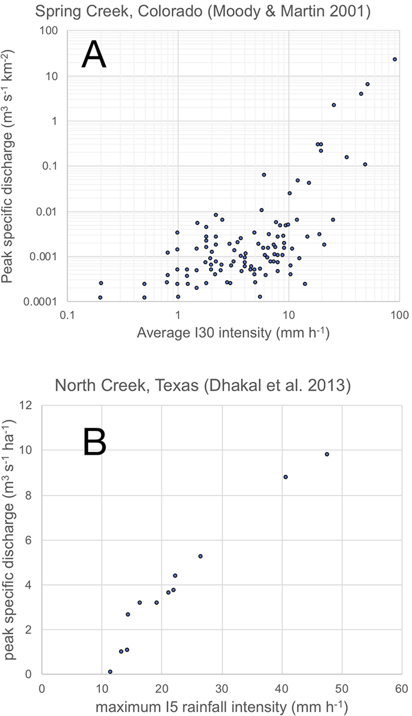
Two examples of field-based relationships established between measures of maximum rainfall intensity and peak specific catchment stream discharge. A: replotted from data in Moody and Martin (2001). B: replotted from data in Dhakal et al. (2013). Note that the units used for peak specific discharge differed between these two published studies.
III The path forward in the study of rainfall intensity and geomorphology
Having considered the above brief review of the influence of rainfall intensity on geomorphic processes, we can consider two issues that cross all of the sub-fields discussed above: What remains to be understood about the significance of rainfall intensity in geomorphology? What challenges and limitations do we face in achieving a more complete understanding?
In terms of what remains to be understood, there are a number of issues that are relevant to many areas of importance in geomorphology, hydrology, agriculture, post-fire erosion, mass movement, catchment erosion, and many others. These include the difficult questions of spatial scaling. Many of the experimental studies of splash, interrill erosion, rill erosion, overland flow, and soil loss are based either on small soil trays or bounded field runoff plots of very limited size. How to scale results to entire hillslopes or indeed to small catchments is not self-evident. For example, the degree of soil surface seal and crust development at small plot scale evidently increases with rainfall intensity; however, in reducing infiltrability and hence promoting surface runoff, upslope soil sealing may lead to more severe surface erosion further downslope. The findings of small plots and soil trays are thus somewhat difficult to interpret without an appropriate landscape context. One approach to moving our understanding forwards is to attempt to move, where feasible, from the process understanding gained from small plot experiments to hypothesis-testing about outcomes that might be expected at hillslope scale. This could rapidly become a very complex challenge, however, because as spatial scale of investigation is increased, soil characteristics, vegetation cover, and indeed rainfall characteristics may all vary. The measurement challenges would be very great indeed. Therefore, a more tractable way forward may well be the development of more sophisticated, spatially distributed hydrologic and erosional models that embody the available process understanding. Because rainfall intensity is a key driver of many geomorphic processes, high-resolution rainfall data would be needed as input to such distributed models; some aspects of this challenge are sketched below.
A further systematic issue that remains to be fully addressed is how the various processes related to rainfall intensity vary geographically. After all, many findings reviewed above show that an hour of rain at some particular intensity has effects on the soil surface, or on slope stability, that vary with the antecedent rainfall. The interval between rainfalls, and their diurnal, seasonal, and annual distribution are characteristics that vary with climatic conditions (e.g. arid or wet tropical) and with the mechanisms responsible for the rainfall (orographic, stratiform, convective, and so on). There are too few studies currently to allow the effects of an hour of rainfall at a dryland site to be compared with the effects of an hour of rainfall at a tropical site; indeed, many studies seem to have proceeded on the tacit assumption that the effects of a rainfall event can be studied in isolation without regard to the season, or the antecedent events (though there are notable exceptions). Seasonally varying activity of soil fauna including ants, termites, etc. and phenology of vegetation growth (as well as rainfall intensity – often greater in the warm season than in winter) suggest that to the contrary, there is a need for seasonal cycles at least to be incorporated in order to build a fuller understanding.
There are a number of significant challenges that will need to be addressed in order to advance our understanding of rainfall intensity and its effects on geomorphic processes and hence on landscapes. These include analysis of the importance of short-term intensity peaks during rainfall (‘intensity bursts’, Dunkerley, 2019b); greater incorporation of fluctuating intensities and intermittency during rainfall – ubiquitous characteristics that are only rarely considered; and the enormous reliance of our current process understanding on rainfall simulation. This is a very useful research tool, but one that offers scope for considerable development in order to better represent the character of rainfall arrival in nature.
3.1 Short-term rainfall intensities (‘intensity bursts’)
In many studies, short-term rainfall intensities have been shown to have explanatory power in accounting for the operating of geomorphic and hydrologic processes that affect runoff or soil loss rates. These include I 5, I 10, I 15, I 30, and others. A short-intensity burst may be one or two orders of magnitude more intense that the mean hourly intensity. The impact energy expended at the soil surface may therefore drive accelerated aggregate breakdown, or seal and crust development, or particle splash. In turn, these effects may configure the soil surface such that subsequent rain, even if at a much lower intensity, is supplied with erodible materials. Many workers have pointed to the perceived importance of short-term rainfall intensity bursts, without necessarily having the required data to explore this. In a study of runoff and erosion caused by natural rainfall on coal mining refuse in Indiana, USA, Smith and Olyphant (1994) observed that every burst of more intense rain during an event resulted in a corresponding peak in runoff rate and sediment flux. In the context of ephemeral gully erosion, for instance, Nachtergaele et al. (2002) pointed to the likely importance of rainfall intensity, but observed that they were unable to explore this adequately because hourly rainfall totals were the best available temporal resolution. As shown above, the use of a one-hour AD in equation (1) is highly likely to result in a severely biased estimate of rainfall intensity and would be entirely unable to reveal the occurrence of intensity bursts. Mertens et al. (2002) showed that including 10-minute rainfall data could yield improved predictions of runoff, in a study that also used the SCS curve-number method, which ignores intensities at such short timescales. Likewise, Radatz et al. (2013) found that I 30 provided a useful threshold parameter accounting for runoff in some agricultural watersheds in Wisconsin, USA. Many more such studies could be cited, but these are sufficient to make clear that, for many geomorphic processes, high temporal resolution in rainfall data is likely to lead to more meaningful understandings of which aspect of rainfall arrival is actually most influential. Such an understanding would furthermore be helpful in envisaging the likely effects of secular change in rainfall, since short-term intensities appear to exhibit a higher scaling with temperature than do intensities over longer times such as daily amounts (Haerter et al., 2010). Finally, it is worth noting that there are problems with the use of short, arbitrary clock-time intervals such as 30 minutes in deriving indexes of intensity that can be applied in geomorphic studies. Rain does not begin and end at clock-time boundaries. Moreover, many potentially erosive convective rainfalls have durations of < 30 minutes, so that indexes such as I 30 cannot be applied. For instance, Ogura and Takahashi (1971) reported from a model study that convective thunderstorm cells had lifetimes of just 15–30 minutes; from a study of more than 130,000 convective storms, Liu and Li (2016) reported a mean lifetime of 23.1 minutes. Almost two-thirds of these storms had durations of between 5 and 20 minutes. Other indexes have therefore been devised that can be applied to rainfalls of any duration (Dunkerley, 2020b).
3.2 Rainfall intensity profile (‘storm profile’)
In their study of rainfall on the island of Mauritius, Nel et al. (2016) emphasised that constant-intensity rainfall events are non-existent there. This comment is probably applicable to most locations on the global land surface. Increasing attention is being paid to intensity profile (or ‘storm type’, or ‘rainfall pattern’, no standard terminology having become established) across a number of sub-fields in geomorphology (Guan et al., 2016). An et al. (2014) explored the importance of intensity profile for hillslope runoff and sediment yield, as did Alavinia et al. (2019). He et al. (2017) explored the significance of intensity profile for rill erosion, and Tao et al. (2017) did likewise for slope sediment transport, though using a modelling framework rather than field observation. Hoober et al. (2017) pointed to the role of intensity profile in gully erosion processes, while Ni and Song (2020) drew attention to its importance in debris flow initiation. Further relevance to mass movement has been documented in the case of shallow landslide occurrence (Fan et al., 2020). In relation to stream sediment transport, intensity profile has been under-explored, though Yuan et al. (2019) established this in relation to flash flood occurrence in small watersheds. On the other hand, stream discharge in small catchments has been monitored in the field, and results have confirmed that indeed rainfall events with late intensity peaks result in a later but larger peak discharge (Wei et al., 2019).
Overall, awareness of the importance of intensity profile across many areas of geomorphology is increasing, but studies exploring this area are still quite rare. Moreover, there are areas where the phenomenon has been explored little or not at all, including some of those discussed above, such as stemflow and throughfall occurrence and erosivity, or the mechanisms of air entrapment, or the intensity of soil splash or seal and crust development. Many worthwhile studies in this area await attention by researchers.
A very neglected aspect of intensity profile is rainfall intermittency. This aspect of rainfall arrival warrants much more attention than it has garnered to date.
3.3 Excessive reliance on rainfall simulation at extreme intensities and durations
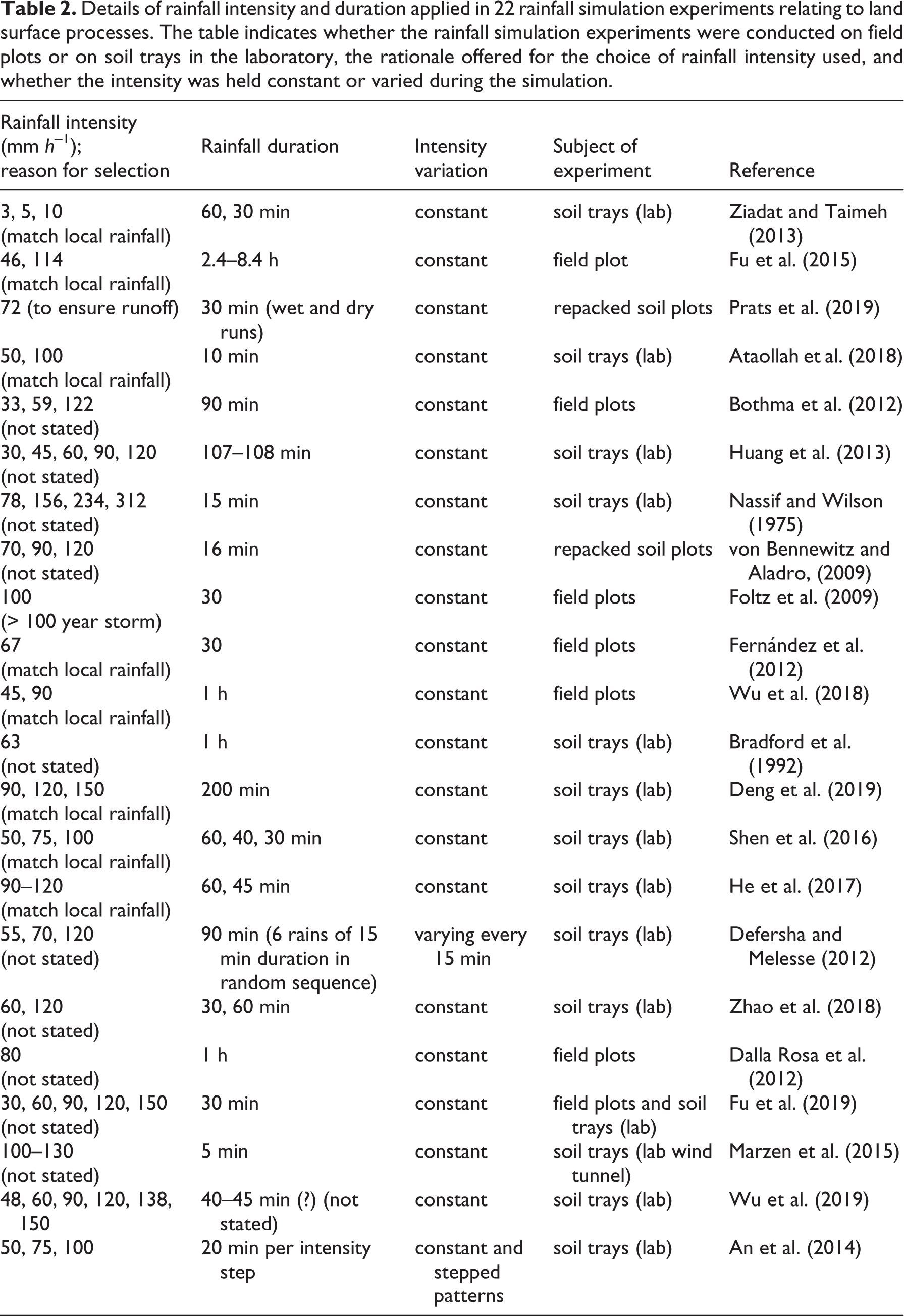
Much of what we know about the kinds of geomorphic processes discussed in this short review, including water partitioning, the occurrence of overland flow, and the erosion of soils, has been related to rainfall intensity far more often by experimentation using rainfall simulation as a research tool, rather than field monitoring of processes occurring during natural open-field rainfall. In one sense this is understandable, since rainfall simulation can be done at the convenience of the researcher, and intensity can be manipulated at will. However, it is now abundantly clear that a reliance on high and constant intensities during such experimentation means that intensity bursts, so characteristic of natural rainfall, are never encountered nor their effects revealed. Likewise, intermittency of rainfall and its effects on ponding and the recovery of soil infiltrability are completely excluded and again their effects remain utterly undetectable. The inability of continuous, constant-intensity rainfall simulation to reveal the effects of these important aspects of rainfall arrival on key land surface processes should signal an urgent need to move to more sophisticated simulations, in which both varying intensity and intermittency are incorporated. Of course, the intensity variation and the intermittency should not be arbitrarily imposed, but rather ideally would relate to the actual rainfall climatology of the area to which it is hoped the results would be applicable. Variable intensity during rainfall simulation has been in use for some time, having been adopted by Frauenfeld and Truman (2004), for instance, in their experiments on interrill erosion in Georgia, USA, and by Parsons and Stone (2006), among others. However, the vast majority of rainfall simulation studies have employed constant rainfall intensity which, as noted earlier, simply does not occur in natural rainfall. Table 2 lists 15 studies and details the experimental conditions used. Whilst many suggest that their intensities correspond to those of local rainfall, the foregoing discussion makes it clear that there is far more to this than simply selecting a constant intensity of arbitrary duration.
Details of rainfall intensity and duration applied in 22 rainfall simulation experiments relating to land surface processes. The table indicates whether the rainfall simulation experiments were conducted on field plots or on soil trays in the laboratory, the rationale offered for the choice of rainfall intensity used, and whether the intensity was held constant or varied during the simulation.
A further problematic aspect of rainfall simulation as the dominant tool employed to explore the impact of rainfall intensity is the choice of intensity used. This is often arbitrarily set to very high values, partly, as mentioned before, owing to the dominance of spray nozzles needing high water pressure for their correct operation, rather than systems using drop-formers that can deliver very low intensities, and which can be halted easily to mimic intermittency. Table 1 lists some examples of the rainfall intensities employed in rainfall simulation. In reading this, it needs to be recalled that the global mean daily rainfall intensity mentioned earlier was < 0.1 mm h –1. In fact, low-intensity rainfall occurs for most of the raining time across much of the global land surface (Figure 1). It was noted above that low-intensity rain might even be more important (because it occurs more frequently) than high-intensity rain in contexts such as tall forests where gravity drops released from foliage that has been wetted even by drizzle can be more erosive than open-field rainfall at higher intensity. Saturation overland flow resulting from prolonged, low-intensity rainfall can likewise result in hillslope erosion and sediment transport, and landslides and debris flows can similarly be triggered by this kind of rainfall, which can have the same outcome as more intense but briefer periods of rain.
Why is the reliance on high intensities for rainfall simulation studies of infiltration, runoff, soil splash, hillslope sediment transport, and many other geomorphic topics hindering the development of our understanding of these processes? The answer is provided by the foregoing review of the influence of rainfall intensity. As intensity increases, infiltration rates may also rise owing to more complete inundation of the soil surface and its microtopography; soil seals and crusts may become increasingly dense and mechanically strong, and therefore drive more of the incident rainfall to become surface runoff; aggregate breakdown and soil splash become more intense, and may provide more erodible materials; rills may be cut into the soil surface sooner, or in greater numbers, or grow to larger dimensions, and so affect the proportions of the soil surface experiencing interrill versus rill transport processes; tillage and other soil surface roughness may be smoothed with a rapidity that increases with intensity. If all of these effects are driven much harder than they would be under natural rainfall, then the effects of the excessive rainfall intensity will feed through into outcomes such as runoff ratios, peak fluxes of overland flow, concentrations of eroded soil particles, and so on. Infiltration rates will emerge that are artificially too high; too many rills will form and introduce unrealistic slope sediment transport processes; air entrapment may occur more extensively than it would under less extreme rainfall intensities, again altering water partitioning and increasing the volume, depth, and speed of overland flow. Unravelling all of this would be challenging indeed without data on how all of the processes affected would work under more normal rainfall intensities (which is really, after all, what we need to know). Together with the effects of unrealistically high intensities, we must recall the lack in almost all published studies of any variation in rainfall intensity at all, and the complete absence of intermittency. We considered above some of the mechanisms that are missed in such work, including the recovery of infiltrability during periods of intermittency.
IV Conclusions
Many of the rainfall characteristics discussed above, including the nature of the intensity profile (early peak, late peak, etc.) and the intermittency (minor or extensive; multiple interruptions to rainfall or few interruptions), as well as, of course, the characteristic intensities when raining, can be expected to vary geographically, differing, for instance, between dryland and wet tropical environments. Thus, our slowness to identify all of these influences on geomorphic processes has not only slowed the development of our process understanding; it may also have prevented us from seeing how differently the characteristics of rainfall arrival in these different environments become manifest in different rates and mechanisms of soil dislodgment, stream flow, and stream sediment transport. Thus, there is likely to be much that remains to be discovered about the role of rainfall intensity in geomorphology. Exploring the under-researched field of climate-related variation in key geomorphic processes may bring useful new understandings that may prove helpful in foreshadowing the effects of secular change in rainfall intensity and other attributes in coming decades, and perhaps planning to manage their impacts. Indeed, this places before us the opportunity for an invigorated and indeed newly refocussed field that we might call ‘climatic process geomorphology’, which would bring insights beyond those of traditional climatic geomorphology, in which the patterns of annual rainfall and temperature were the key parameters used to explore weathering, erosion, and geomorphology. We now have a much-enhanced capacity to explore geomorphic processes and their effects on landscape form and process; progress will be greatly boosted by an increased focus on the aspects of rainfall arrival, and especially of rainfall intensity and its spatio-temporal variability, as sketched in this review. Some of the remaining challenges, such as how to scale-up our process understanding from soil trays and small field plots to hillslopes and small catchments, are considerable. They may well require the wider use both of improved rainfall intensity and arrival data, ideally sub-hourly, as well as more holistic, areally distributed hydro-geomorphic models. All of these challenges suggest that improved understanding of land surface processes is possible as geomorphic experimentation and modelling continue to develop.
Finally, we need to recall that rainfall intensity, as for many drivers of geomorphic processes, follows some form of extreme value distribution. The most intense rainfalls may only occur very infrequently. This poses an additional challenge to the refinement of our understanding of the impact of rainfall intensity on landscapes. To monitor and resolve the effects of uncommon and rare events will require, as Keefer et al. (2016) pointed out, the simultaneous use of dense rainfall observation networks, high temporal resolution in the collected data, and long-term data collection.
Footnotes
Declaration of conflicting interests
The author(s) declared no potential conflicts of interest with respect to the research, authorship, and/or publication of this article.
Funding
The author(s) received no financial support for the research, authorship, and/or publication of this article.