
Abstract
Physical geography (PG) is currently experiencing a subtle revolution that reinterprets old ideas in light of new scientific, social, and environmental challenges. This paper addresses the thematic areas of climatology, biogeography, hydrology, geomorphology, and the cross-cutting role of geospatial technologies in disaster risk reduction, and speaks to geographers, environmental scientists, and policy-oriented scholars concerned with the implications of global change. Its importance lies in reframing PG not only as a technical discipline but also as a critical and integrative field, socially situated, capable of contributing to sustainability and socio-environmental justice. The key problem identified is the persistence of fragmented and technicist approaches that overlook the entanglement of natural processes with social, political, and cultural dynamics. Our central aim is to assess how different fields are incorporating integrative frameworks and to evaluate their role in shaping a renewed disciplinary identity. Climatology increasingly incorporates the social dimension of climate and the assessment of inequality through socio-economic scenarios to contextualize climate change. Biogeography integrates ecosystem services to link conservation with human well-being. Hydrology recognizes the hydro-social dimensions of water, reframing debates on justice and governance. Geomorphology engages critically with the political production of landscapes and their implications for spatial justice. Together, these developments indicate that PG does not weaken by engaging with social sciences; instead, it strengthens its explanatory capacity and enhances its societal relevance. We argue that this subtle revolution, grounded in long-standing geographical traditions, positions PG as a reflective, interdisciplinary, and socially engaged science. By overcoming the dichotomy between the physical and the social, PG can better address global environmental change, territorial conflicts, and sustainability challenges. Drawing on recent review literature and illustrative case-work, we examine the extent to which these fields are transcending technical specialization to address complex socio-environmental challenges through a critical, integrative lens.
Keywords
Introduction
In its early forms, geography did not draw a strict boundary between the physical and the human. The very notion of “physical geography” (PG) as a field divorced from human concerns would have made little sense to figures such as Alexander von Humboldt or Carl Ritter, whose scientific practices embodied a holistic vision of the natural and social worlds. The division between physical and human geography is, in fact, a modern construct consolidated particularly in the 19th century through the process of disciplinary specialization within the sciences. While every practice in PG involves philosophical decisions, even if often implicit (Inkpen and Graham, 2013), the discipline has recently begun to look beyond the technical, emphasizing the need for more integrative and reflective frameworks. In this regard, recent epistemological debates have reinforced the value of methodological pluralism, while increasingly scrutinizing the situated nature of fieldwork and the normative, socio-political dimensions of PG research.
PG integrates the analysis of the territory as a socio-ecological system, combining the explanation of physical processes with an examination of how these dynamics co-evolve to impact inhabiting communities. However, the discipline’s approach to the territory has evolved shifting between a focus on isolated physical processes and broader territorial contexts (Anríquez et al., 2024; Elden, 2021). This trajectory, driven by increasing specialization within fields, has historically contributed to a fragmentation of PG.
In recent decades, the integration of technical specialization and the intensive use of computational tools, have deeply influenced the discipline, while the rapid rise of artificial intelligence (AI) is now adding a new layer of complexity to the disciplinary identity of PG. Recent horizon scans have identified specific emerging topics such as AI or health geography as key frontiers (Anderson et al., 2023). However, while this is not new for the discipline, since it historically took advantage of numerical methods from Earth sciences especially from the mid-20th century, intentions, methods, and needs are set to produce a change in PG. Socio-ecological interactions necessarily condition the processes and functioning of the natural environment, therefore, analyzing and understanding trends in areas that are not specific to PG (e.g., population growth, urbanization, energy use, production, mobility, social bias in the access to environmental benefits, and politics) are of paramount importance for the future of the discipline.
The development of a process-centered orientation in PG in the late-20th century entailed a change in the definition of the discipline. It contrasted with previous approaches by focusing primarily on the form or state of geographic elements, without delving into the mechanisms that created or maintained them (Strahler, 1954). As each subdiscipline of PG became more familiar with this new approach, there was an increasing need to draw on other disciplines for the theoretical, field, and, increasingly, mathematical techniques needed for analysis. This made the core of PG’s study more difficult to define. The pursuit of a unified explanatory framework gave way to a retreat into specialized disciplinary niches (Inkpen and Graham, 2013). In this paper, we use “subtle revolution” to denote cumulative, field-internal shifts that reframe long-standing ideas rather than abrupt paradigm breaks. We therefore focus on changes in practice (problem framing, mixed evidence, ethical awareness) rather than only on tools. This choice also motivates our selection of four fields as bellwethers of disciplinary change.
We argue for a transdisciplinary PG useful to solve research questions and territorial problems. While the scientific community seems to take small steps in this direction with its new approaches, the integrative idea of geography is already at the core of the discipline (Colven and Thomson, 2018; Goudie 2016; Harrison et al., 2004; Massey, 2004). Revisiting the original identity of geography is sufficient to trigger the necessary changes. Essentially, PG requires a shift towards a stronger social perspective to address complex territorial problems. While such “turns” are not unprecedented, having occurred in human geography (Lindon and Hiernaux, 2010), remote sensing (Bennet et al., 2022), and even in PG (Colucci et al., 2023; Lave, 2015), past shifts were largely restricted to regional scales and well-defined boundaries. In contrast, today’s global environmental challenges, particularly climate change, have blurred these boundaries, necessitating a broader and more integrated perspective.
This article presents a reflective synthesis across climatology, biogeography, hydrology and geomorphology, focusing on their contribution to a renewed disciplinary identity. We review state-of-the-art literature that moves beyond purely technical instrumentation to integrate social and biophysical processes. Adopting a critical-realist stance, where “critical” denotes an active questioning of the power relations and socio-economic assumptions embedded in scientific practice, we treat material processes as measurable while acknowledging that data and models are co-produced within political contexts. Consequently, we prioritize research that validates digital models through fieldwork and ensures practical relevance for governance, avoiding abstract naturalism to situate the discipline within a socio-biophysical praxis.
To synthesize the nature of this transformation, we propose a conceptual framework (Figure 1), where the intersection of biophysical and social domains generates four distinct forms of explanatory value: (1) PG contributes empirical constraints that bound plausible social narratives within material reality; (2) it offers process-based causal insight to identify the specific physical mechanisms driving exposure and vulnerability; (3) it applies rigorous spatio-temporal scaling to effectively link local events with global regimes; and (4) it reinforces uncertainty and ethics standards, promoting reproducibility and justice-aware analysis as antidotes to black-box technocracy. Conceptual framework of the subtle revolution in PG. The integration of biophysical and social domains (the integrative praxis) generates specific methodological and epistemological values. Rather than dissolving disciplinary identity, this hybridization creates a reciprocal exchange: PG gains societal relevance, while social analysis gains material grounding through (i) empirical constraints, (ii) causal mechanisms, (iii) scalar rigor, and (iv) ethical transparency.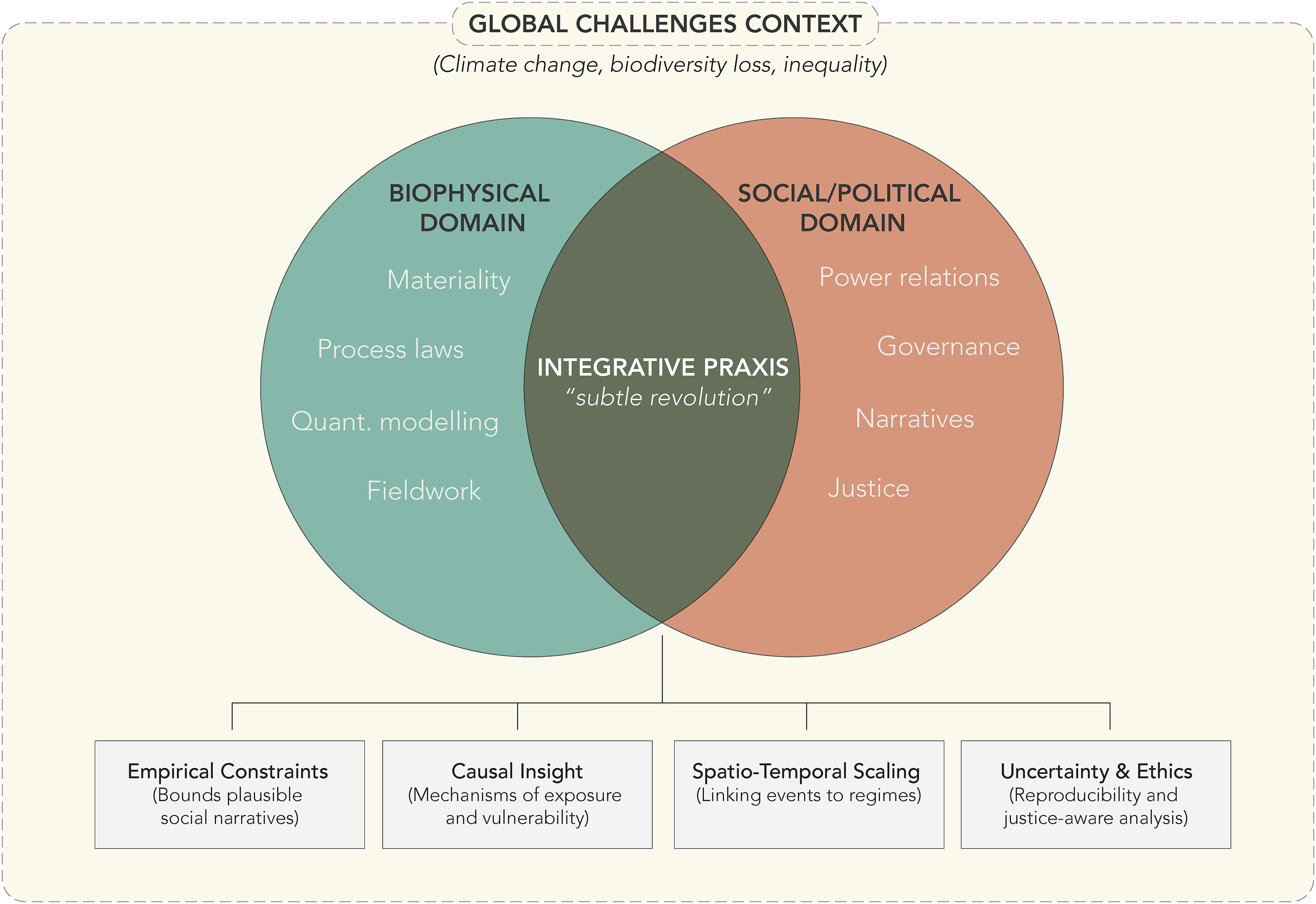
Methodological contributions of geography to the study of climate change
Contemporary climatology is “new” insofar as it delivers impact-calibrated indicators that couple atmospheric dynamics with governance-ready metrics (compound heat, drought fingerprints, and glacier mass balance) with explicit uncertainty and provenance. In this context, physical climatology is crucial for defining the empirical constraints that bound plausible socio-economic futures, while simultaneously grappling with the communication of uncertainty in adaptation strategies
Geographers play a key role in promoting a cultural shift in climate change responses by examining how scales shape actions, knowledge, and priorities, particularly through the rescaling of environmental governance and concepts like “the global climate” (Pietta, 2023). This integration is exemplified by the widespread adoption of Shared Socio-economic Pathways (SSP) in recent climate assessments (IPCC, 2023). By linking physical projections to storylines of sustainability, regional rivalry, or fossil-fueled development, these frameworks explicitly acknowledge that future climate states are inseparable from socio-political decisions.
For this reason, climate science on its own is not enough to fully address and assess the impacts of global change in society and territory, as is recognized by other disciplines such as social, behavioral, economic, biological, and environmental sciences (Desmet and Rossi-Hansberg, 2024; Jorgenson et al., 2019; Kou et al., 2025; Mooney et al., 2013; Nielsen et al., 2024; Nordhaus, 2019; Sage, 2020; Vlasceanu et al., 2024). Applied climatology has evolved from purely physical science into a field that recognizes climate knowledge as a political and situated practice (Tadaki et al., 2014). The distinct contribution of PG lies in bridging this critical awareness with technical capability. While advances in big-data, remote sensing, and machine learning are utilized across many sciences, geographers uniquely employ them to spatially contextualize physical variables, such as heat-risk mosaics or glacier loss, within complex socio-territorial systems (Wulder and Coops, 2014; Zhao et al., 2021). This approach moves beyond historical climatic determinism (Randalls, 2017) towards a methodological pivot: coupling high-resolution observations with socio-economic scenarios to produce decision-ready indicators. The distinctive move is from atmospheric dynamics alone to impact-calibrated climate services that are traceable (data provenance), uncertainty-aware, and directly mapped to territorial options (alerts, zoning, and adaptation portfolios). Some approaches, not necessarily from PG but from geography, have tried different ways of exploring how the geographers should address climate change in order to ensure effective communication of the problem, from storytelling (e.g., Gillespie, 2020; Verlie, 2021), to more personal visions (Head, 2016).
Biogeography at the intersection of ecology, statistics, and societal benefits
The pivot in biogeography is characterized by model-to-policy coupling. For instance, Species Distribution Models (SDMs) calibrated with bias-aware occurrence data and mechanistic covariates (dispersal limits, demography, and microclimate) now generate actionable layers for connectivity corridors and vector-borne risk niches. The distinctive step moves from correlational maps to intervention portfolios co-designed with managers. This approach is exemplified by systematic conservation planning, where spatial prioritization algorithms explicitly account for management costs, conflicting objectives, and implementation uncertainty (Guisan et al., 2013; Moilanen et al., 2009). In doing so, the discipline moves beyond simple correlation to provide the causal insight necessary to identify the mechanisms driving socio-ecological vulnerabilities.
Modern biogeography has integrated ecosystem services as a foundational pillar for defining conservation objectives (Potschin and Haines-Young, 2011). Rather than proposing nature as a tradable commodity, the current narrative emphasizes its functional utility, framing ecosystems as indispensable infrastructure for human health, safety, and prosperity (Barbier et al., 2009).
As human pressures on ecosystems intensify and climate change exacerbates ecological vulnerability, biogeographers are increasingly driven by the urgency to produce knowledge that directly informs conservation strategies and public policy. The goal is not only to understand natural processes but to use that understanding to design interventions that safeguard both biodiversity and societal stability. A recent and illustrative case is the COVID-19 pandemic, which underscored the relevance of biogeographical thinking in global health crises. While early investigations focused on identifying viral reservoirs, recent integrative research explores “pathogenic landscapes,” analyzing how bioclimatic, land-use and geomorphological dynamics interact to facilitate zoonotic spillovers (Anderson et al., 2023; Han et al., 2023; Pan et al., 2024; Tooth et al., 2024; Weaver et al., 2022). This systems-level approach, rooted in the spatial logic of biogeography, demonstrated how environmental and epidemiological models can be combined to anticipate and mitigate emerging threats.
At the heart of this integrative framework lies statistical modeling, which has become an indispensable tool for quantifying and understanding biogeographic processes (Crovello, 1981). The development and widespread adoption of SDMs exemplify the field’s methodological sophistication by using statistical algorithms to model the relationship between the presence of a species and environmental variables, and allowing the prediction of its potential distribution in space and time (Peterson and Soberón, 2012). Their versatility has made them applicable in conservation planning, invasion biology, epidemiology, and ecosystem service assessment (Franklin, 2013). Statistics, in this context, do more than quantify; they legitimize biogeography as a predictive and policy-relevant science. The need for reproducibility, transparency, and scalability in conservation science demands robust quantitative methods. By leveraging large datasets and computational advances, biogeographers can now model complex ecological phenomena with greater accuracy and provide decision-makers with actionable insights (Golafshani, 2015; Pearse et al., 2018; Rangel et al., 2006).
As we navigate an era of unprecedented ecological change, the integration of ecological understanding, quantitative rigor, and human-centered values positions biogeography as a pivotal science in the pursuit of a sustainable future.
Hydrology: From water cycle to social-water systems
Hydrology becomes socio-hydrology when human decisions create feedback loops with basin states, re-situating justice and governance as internal to the cycle. Although geographers have focused on water-society relationships (Liao and Schmidt, 2023), most studies have approached the hydrological cycle through parallel lines: physical geographers analyze the component of water cycle (e.g., precipitation, runoff, and evaporation) whereas human geographers study water use and governance. This disciplinary divide results in fragmented knowledge making precise scenario modeling difficult and hindering effective management of water resources (Sivapalan and Blöschl, 2015). Although debates on hydro-social versus hydro-physical approaches date back at least to the 1970s, only in the 21st century onwards, have systematic attempts been made to reconcile them through the lenses of socio-hydrology and political ecology (Boelens et al., 2016; Gleick, 2003; Liao and Schmidt, 2023). Indeed, fewer than 8% of hydrology papers in 21st century quantitatively integrate human drivers (Van Loon et al., 2024).
The hydrological turn is the explicit closure of feedback between human decisions and basin processes: withdrawals, Land Use/Land Cover (LU/LC), and allocation rules reshape evapotranspiration, infiltration, runoff, and storage, which in turn restructure exposure and governance choices. Socio-hydrology operationalizes this with joint state variables (streamflow, water storage, evapotranspiration) and human states (demand, rules, prices), basin-scale models that include institutions, and validation against events (compound floods/droughts) and management outcomes. As Wilby and Keenan (2012) emphasize, hydrology is no longer confined to measuring flows but plays an active role in reducing risks from hydrometeorological hazards. This shift requires re-evaluating the physical water cycle through an ethical lens, where hydrological data serves not just to model flows but to support justice-aware analyses of water access and governance.
Bridging the duality of physical and human geography requires explicitly representing this feedback. Previous studies already address this duality: Willemin and Backhaus (2023) and Alba et al. (2025), for example, demonstrated that pesticide dynamics function as drivers of territorial reconfiguration: chemical inputs boost production but trigger ecological degradation that subsequently reshapes land-use policies. Similarly, Savelli et al. (2021) analyzed the impact of a megadrought in Cape Town, concluding that social power dynamics often override physical scarcity in determining water security.
Looking to the future, these integrated approaches will be the cornerstone of climate adaptation. Hydrology must advance by integrating remote sensing, AI—a priority area for PG’s future (Anderson et al., 2023; Morain et al., 2024)—with participatory approaches to address vulnerability across scales. Ultimately, the future of hydrological research lies in bridging physical science with governance, ensuring that water management is equitable, resilient, and responsive to the complexities of a rapidly changing planet.
Rethinking geomorphology: Between critical engagement and methodological shift
Geomorphology occupies an ambiguous position within academia, taught across two disciplines with distinct trajectories: geography and geology. In the latter, it holds a secondary role, subordinate to dominant subfields like structural geology or stratigraphy. By contrast, in geography—often aligned with the social sciences—geomorphology typically constitutes a core component of PG, where it plays a central role in landscape interpretation and environmental analysis. These divergent affiliations can generate contrasting approaches and epistemological tensions within the discipline (García, 2025).
Since the mid-20th century with quantitative tradition, geomorphology has embodied a positivist outlook, privileging technical analysis while ignoring the socio-political contexts that shape landscapes. This naïve view (Capel, 1983) may have limited the field’s critical potential. A shift toward complementary and pluralistic epistemologies implies acknowledging the socio-economic and political drivers behind landform transformation. As highlighted by recent scholarship (e.g., Brown et al., 2017; Tooth et al., 2015), understanding landscape dynamics often requires integrating positivist methods with social frameworks. This perspective positions geomorphology not as neutral, but as a tool capable of informing spatial planning, risk governance, or environmental justice debates. This reorientation is occurring progressively, where it is occurring, through new technologies, a critical reassessment of disciplinary foundations, and growing sensitivity to the social impacts of geomorphological change. In this context, geomorphology increasingly recognizes humans not just as observers but as agents of landscape transformation (García et al., 2021). Erosion, for instance, is no longer seen as purely natural, but as shaped by farming practices, policy decisions, and market logic (Poesen, 2018). This perspective reconnects the discipline with soil science, which has long prioritized applied research on sediment budgets and land degradation (Quesada-Roman et al., 2025). Geomorphology can also be conceived as a valuable tool for thinking through spatial justice and anticipating the unequal effects of climate change on territories (Sepúlveda and Petley, 2015). By engaging with critical theory, geomorphology offers robust empirical constraints to ground political ecology narratives, revealing the specific physical processes—and causal mechanisms—through which power relations are inscribed into the landscape.
Accordingly, landforms within anthropogenic systems should no longer be treated as isolated “natural” objects but as hybrid artifacts co-produced by human and non-human agents. Various studies illustrated how gullies in agricultural fields (Quinton and Fiener, 2023), often seen as local issues, link to global forces such as commodity trade or EU subsid and policies (Panagos et al., 2020; Vergamini et al., 2024). Critical geomorphology, in this sense, offers conceptual tools to reveal how political economic processes leave tangible marks on the land, which can be read as geomorphological archives of territorial conflict.
This epistemological reorientation coincides with a profound methodological transformation. Long-standing practices (e.g., direct observation, landform recognition, and in situ measurement) are increasingly being replaced, or at least supplemented, by digital approaches. Technologies like remote sensing, LiDAR, UAVs, GIS, and AI-based models have redefined how geomorphologists observe and represent terrain. While offering new analytical possibilities, these advances also increase detachment from field-based investigation, a hallmark of the discipline (Church, 2013; Houser et al., 2022). In consequence, fieldwork is increasingly sidelined in favor of data processing and remote modeling, transforming geomorphology into a desk-bound activity. Lane (2014), for instance, raises concerns about this trend, warning that the increasing reliance on simulation models risks distancing science from the very places and practices it aims to comprehend. While not negative per se, this shift entails epistemic trade-offs. UAVs, for instance, can produce highly accurate 3D models of inaccessible terrains, yet may fail to foster deeper sensory or interpretive engagement.
The critical issue, therefore, lies not in the use of digital tools, but in the illusion of objectivity they may produce. Remote data collection often masks the interpretive frameworks, assumptions, and material conditions shaping data (Couper, 2023; Inkpen and Graham, 2013). Lundmark et al. (2020) highlight how digital field tools like FieldMove enhance efficiency but may not always promote conceptual understanding or critical thinking grounded in place-based experience. Concurrently, a generational shift is affecting geomorphological training. Many doctoral students are digital natives, proficient in modeling and spatial analysis, but less experienced with fieldwork. Curricular reforms, where geography merges with history or geology with biology, further dilute geomorphology’s specificity. The epistemic and pedagogical value of fieldwork is at risk of being subordinated to digital techniques. The geomorphological pivot is paired evidence: every digital product (UAV, ML segmentation, and LiDAR differencing) is tied to minimum field control (GCPs, stratigraphic logs, and sediment panels) and explicit positionality/assumptions note. This safeguards process inference (e.g., connectivity, thresholds, and sediment budgets) and keeps measurement central while opening to governance-relevant diagnostics (e.g., erosion hotspots, mass-movement runout, and channel capacity).
Beyond the management of hazards and degradation, the shift is also evident in the growing field of geoheritage and geoconservation. Here, geomorphologists engage directly with cultural values, policy, and public well-being by framing landforms not just as physical entities but as assets of social and aesthetic significance (Gray, 2019).
In this context, the dual transformation—epistemic and methodological—positions the notion of critical geomorphology as an invitation to engage productively with social questions and the power relations inscribed in landforms. Yet it also raises fundamental challenges. Does it expand the discipline’s reach or dilute its core into the social sciences? Can the value of empirical observation be upheld in a framework that favors critique over measurement? Is it possible to maintain geomorphology’s intrinsic value without it being absorbed by external logics? These tensions do not call for a binary choice between tradition and transformation. Rather, they offer a dual opportunity. On one hand, embedding geomorphology in broader socio-environmental debates strengthens its public relevance and institutional visibility. On the other, reaffirming its intrinsic worth as a discipline capable of interpreting landform dynamics across scales and producing essential diagnoses in crisis contexts ensures that it remains grounded. Critical geomorphology should not replace traditional approaches, but complement them. Its role is not to dissolve geomorphology into the social sciences, but to extend its relevance, fostering dialogue without losing disciplinary integrity. The field must retain its empirical core because staying grounded in every sense remains essential for its scientific vitality and societal contribution.
The adaption to a new era: Critical GIS and remote sensing for disaster risk reduction
Remote sensing and GIS are not neutral disciplines either: their image production extends beyond the visible spectrum, and analytical decisions are shaped and motivated by political interests, representations, and uses (Blue and Brierley, 2016). From this perspective, the added value of GIS and remote sensing, combined with social data, lies in their ability to analyze the socio-spatial distribution of exposures and benefits with fine resolution and wide coverage, thereby strengthening the empirical basis for public decision-making. Crucially, these technologies provide the spatio-temporal scaling frameworks necessary to link local disaster events with broader global regimes of environmental change. For example, high-resolution land-surface temperature mosaics combined with census micro-areas can identify heat-risk inequities; a simple trigger-matrix (threshold × exposure × governance capacity) then directly links maps to actions (e.g., targeted street-tree planting, cool roofs, or revised zoning during heat alerts).
A more proactive approach, seeking anticipation in the face of extremes rather than limiting itself to analyzing them only a posteriori, requires an intensive use of modeling, simulation, GIS, and remote sensing to identify and spatialize hazards and vulnerabilities, while advancing the integration of real-time data, big data, and participatory tools to improve decision-making (Joshi et al., 2004; Saranya et al., 2024). However, we should avoid the solutionism that equates “more data” with “better policy.” A critical remote-sensing agenda advances three aims: (1) situate the geopolitics of image production and analysis; (2) question developmental grand narratives (e.g., the assumption that greater satellite-observed nighttime lights signify progress); and (3) ground satellite interpretations through qualitative and ethnographic work (Bennett, 2020).
Building on this shift, integrated research agendas now combine land-use planning with nature-based strategies to mitigate risks (Kato and Huang, 2021). Furthermore, citizen science and low-cost sensor networks are democratizing data collection, filling information gaps in data-science regions and enabling rapid disaster response (Pandeya et al., 2021; Trojan, 2024), though these demands ensuring critical spatial literacy.
Environmental justice movements have reframed risk as a matter of responsibility, equitable distribution, and participation in decision-making, challenging technocratic and privatized approaches to risk management (Hirsch, 2020). The distribution of environmental risks is deeply linked to social inequalities, and marginalized groups often face greater exposure and less recognition or participation in decisions (Curran, 2018; Satterfield et al., 2004). As an exemplar of how critical GIS can help, an essential ethical note when publishing high-resolution cartography is to recognize that making facts visible on the ground is a political act, and that assessing risks and exposures, including people and sensitive infrastructure, is part of responsible practice. This is consistent with the call from critical remote sensing to contextualize, and to avoid pixel fetishism (Bennett, 2020; Bennett et al., 2022).
The technological horizon of this subtle revolution is rapidly expanding through the integration of AI, Machine Learning (ML), and Big Data. While these tools offer unprecedented capabilities for pattern recognition, they also introduce epistemological risks. Houser et al. (2022) warn that the growing reliance on ML in geomorphology may widen the gap between the researcher and the landscape. Furthermore, the emergence of Large Language Models (LLMs) challenges physical geographers to critically evaluate how environmental knowledge is synthesized. Reflecting current disciplinary concerns, recent discussions in the wider geosciences’ community (e.g., Cleverley, 2025) emphasize the need to ensure that algorithms remain grounded in physical reality.
Critical currents in geography and in geospatial technologies seek to democratize knowledge production, question assumptions of objectivity, and make visible the political, social, and ethical dimensions of data and methods. Citizen science, critical GIS and remote sensing, converge in participatory, inclusive, reflective, and socially responsible approaches (Bennett, 2020). It is important to underscore the need to advance critical spatial literacy and the use of mixed methods that bring together quantitative and qualitative data, along with feminist and decolonial perspectives in mapping (Kroth, 2025; Mahony, 2022).
Critical physical geography: Towards a transformative and integrative praxis
Acknowledging that biophysical landscapes are increasingly co-produced by social, economic, and political forces requires frameworks capable of navigating these entanglements. Building upon the critical perspectives emerging in specific fields, as previously noted, this imperative has inspired increasingly pointed critiques of approaches that treat biophysical systems as independent from power relations, that frame environmental problems as purely technical challenges, or that presume the political neutrality of scientific practice, crystallizing in the emergence of Critical Physical Geography (CPG). CPG represents a radical reconceptualization of the discipline—one that seeks to integrate biophysical and social analyses through politically committed, epistemologically reflective, and methodologically hybrid approaches. Within this framework, the term “critical” does not merely signal political alignment but denotes a specific epistemological stance: the systematic questioning of the presumed neutrality of environmental data and the foregrounding of its socio-political conditions of production—while simultaneously recognizing that those same data, once reframed, become powerful instruments for revealing patterns of environmental inequality and the uneven distribution of ecological harm. While some analyses of higher education programs suggest that CPG remains a niche identity within the broader discipline (Gregory and Lewin, 2020), and that educators face challenges navigating the “STEMification” of the curriculum (Seitz et al., 2024), its epistemological and methodological influence is increasingly evident in research aimed at solving complex socio-environmental problems.
Far from being just another methodological label, CPG is an effort to rebuild the foundations of geographical inquiry around epistemic and environmental justice, rejecting the separation of landscapes from the power structures that shape them. As formalized by Lave et al. (2018), CPG draws on three core intellectual traditions to overcome their individual limitations. First, it answers Walker’s (2005) critique of political ecology by recentering biophysical processes in the analysis of inequality, examining how uneven environments are materially produced. Second, it applies Science and Technology Studies (STS) to scrutinize how scientific knowledge itself is produced, legitimized, and circulated treating science as a powerful actor in environmental governance. Lastly, it expands the LU/LC research beyond surface-level modeling, using its spatial and quantitative tools to rigorously quantify the material impacts of these socio-political dynamics.
CPG builds on these traditions while pushing beyond the limitations of isolated disciplinary approaches—developing a more reflective, politically engaged, and materially grounded understanding of how socio-biophysical landscapes are produced, managed, investigated, and conceptualized. As a key takeaway, “its central precept is that we cannot rely on explanations grounded in physical or critical human geography alone because socio-biophysical landscapes are as much the product of unequal power relations, histories of colonialism, and racial and gender disparities as they are of hydrology, ecology, and climate change” (Lave et al., 2014).
CPG is not merely a subfield or a call to advocate interdisciplinary collaboration within geography for its own sake—it is a praxis: a transformation in how we frame problems, pose questions, and engage with the world to advance environmental justice. In this sense, the goal is not simply to add social theory to PG, nor to treat empirical data as merely illustrative of social science hypotheses, but to develop truly integrative explanatory frameworks capable of addressing contemporary environmental crises in all their material and political dimensions. This integrative praxis also extends to the creative and aesthetic dimensions of the discipline. As argued by Hawkins (2020), engaging with art-science collaborations and creative geographies allows physical geographers to visualize complex environmental processes and communicate the “force” of materiality to wider publics, transcending the limits of traditional technical reporting.
This epistemological shift necessitates a re-evaluation of what constitutes “theory” in PG. While discipline has traditionally grounded itself in physic-chemical laws, the argument of subtle revolution aligns closely with the tenets of critical realism (Bhaskar, 2008). This philosophical stance accepts the ontological reality of biophysical processes (independent of human perception) while acknowledging that scientific knowledge production is socially situated. A tangible manifestation of this convergence is the concept of the “Critical Zone” (Giardino and Houser, 2015), a rigorous boundary for studying complex chemical, biological, and physical interactions. This convergence has been famously embraced by social theory through the work of Bruno Latour, who reframed the Critical Zone not merely as a biogeochemical reactor but as a new political territory for habitation (Latour and Weibel, 2020). As Mahony (2022) and Wiame (2023) argue, this zone is also a political space where scientific data, FAIR principles, and AI meet societal decision-making. In this sense, the Critical Zone functions as a practical bridge where physical principles and social analysis can be effectively integrated.
This is not a call for every geographer to become a modern-day Humboldt—such a task would be both unrealistic and undesirable. Rather, it is a call to expand and institutionalize the kind of integrative work that many geographers already practice, but which often remains undervalued in disciplinary structures and funding mechanisms that privilege narrow specialization and a fast science model that hinders the maturation of integrative collaborations. Ultimately, CPG invites geographers to embrace a more self-reflexive and politically conscious form of inquiry—one that transforms how geography is practiced in pursuit of deeper environmental and social transformation.
Conclusions
The critical synthesis presented in this paper highlights that PG is undergoing an epistemological and methodological transformation that is reconfiguring its disciplinary identity. Rather than representing a rupture with its tradition, this process can be understood as a subtle revolution: a movement that draws upon ideas historically embedded within the discipline yet rearticulates them in ways that respond more effectively to the contemporary socio-environmental challenges. This approach also entails an ethical and political rethinking of the role of geographers, who are increasingly called upon not only to explain processes but also to contribute actively to sustainability and socio-environmental justice agendas. Ultimately, the success of this subtle revolution will be measured not by the sheer volume of new data or models, but by the capacity of integrative, justice-aware analyses to effectively inform territorial decisions.
In an era marked by climate change, biodiversity loss, water crises, anthropogenic geomorphic change, and deepening territorial inequalities, it becomes imperative to transcend fragmented and technicist perspectives and to advance integrative frameworks that account for the complex interplay between physical processes, social dynamics, and power relations. The capacity to adopt such frameworks reflects not only methodological innovation but also the recovery of geography’s holistic tradition, where the interconnections between nature and society are placed at the core of analysis. In this sense, interdisciplinarity emerges not as an accessory, but as a constitutive feature of a renewed PG.
The case studies reviewed illustrate a shared trajectory across climatology, biogeography, hydrology, and geomorphology, where technical analysis is increasingly integrated with social frameworks to address global change. In geomorphology, while this shift is nascent, the emergence of critical frameworks offers a necessary path to engage with the political and cultural dimensions of landscapes and to scrutinize the epistemological implications of the transition from field-based to digital approaches. Together, these developments demonstrate that PG does not lose its disciplinary strength when engaging with other fields of knowledge; rather, it consolidates its explanatory power and societal relevance. Crucially, it enriches human geography by contributing process-based understanding of Earth systems, spatio-temporal environmental data, and methods for quantifying physical uncertainties.
The challenge ahead lies in sustaining this integrative praxis, capable of addressing environmental and territorial problems in their full material and political dimensions, thereby reaffirming the discipline’s contribution to sustainability and socio-environmental justice. This requires not only methodological creativity but also a sustained commitment to genuine collaboration across disciplinary boundaries. Ultimately, PG’s subtle revolution is not simply about new tools or approaches, but about reasserting geography’s vocation to understand and transform the world in a holistic, critical, and socially engaged manner.
Footnotes
ORCID iDs
Funding
The authors disclosed receipt of the following financial support for the research, authorship, and/or publication of this article: R. Serrano- Notivoli is supported by Agencia Estatal de Investigación through grants RYC2021-034330-I and PID2024- 157662OB-C21 funded by MCIN/AEI/10.13039/501100011033 and by European Union NextGenerationEU/PRTR, and by grant CAS24/00020 funded by Ministerio de Ciencia, Innovación y Universidades (Spain). H. García is supported by Ministerio de Ciencia e Innovación through grant PID2021-125938OA-I00. P. Smith and P. Sarricolea thanks to Chilean National Agency for Research and Development (ANID) through FONDECYT 1221688, and FONDAP/ANID 1523A0002. O. Meseguer-Ruiz is supported by ANID grant FONDECYT 1250416. M. Prieto is supported by ANID grants FONDECYT 1250458, ATE240007, and NCS2022_009.
Declaration of conflicting interests
The authors declared no potential conflicts of interest with respect to the research, authorship, and/or publication of this article.