



Abstract
Researchers generally examine how variables directly affect events in war. Some variables, however, may not simply increase or decrease conflict events but may instead displace them. In wartime, this dynamic may result from the conditional decision-making made by militaries constrained, at least partially, by time. When there is a necessary regularity to military operations, decision-making may be complicated by factors such as inclement weather, and this regularized pressure to act may produce a hydraulic relationship between inclement weather and events. In this dynamic, today’s inclement weather, such as rain, may displace today’s events. Conversely, yesterday’s rain may increase today’s, with planned events postponed. Similarly, tomorrow’s rain may also increase today’s events, with planned activities moved forward. We test this hydraulic argument with geo-referenced data from the recent Ugandan civil war and find significant evidence that conflict events are fluid in time. Inclement weather constrains and also displaces events.
Introduction
The conflict literature has only recently begun to consider climate and weather, and the question of their significance remains unsettled. 1 Much of this research examines the potential relationship between conflict and monthly or yearly variation in temperature and precipitation. The majority of these studies focus upon the motivations of actors to begin and sustain conflicts. The possible day-to-day influences of weather, however, have received much less attention. If the effects of weather extend beyond motivations for initiating or continuing conflict, and separately influence the dynamics within conflicts, then it is also important to understand these effects. The variation in daily weather may explain much within conflicts, including much of the planning and execution of military operations, and thus, the distribution of wartime violence. 2 As insurgencies account for an ever increasing share of such violence, it is especially important that policy-makers understand how violent events are distributed in time within these wars. Recent attention to temporal patterns in violence has begun to address this need (Hassner, 2011; Medina et al., 2011; O’Loughlin et al., 2010a), but there is still much that is unknown about the timing of violence. As such, to better explain the events within wars, in some respects the substance of wars, the study of daily weather may be necessary. In this paper we begin to address this by proposing a hydraulic relationship between daily-level weather and conflict events, in which precipitation reshapes the distribution of conflict events at the micro level. We test this theory with data from the ongoing conflict in Uganda.
Scholars have shown that the spatial element of conflict is sometimes inappropriately considered (Buhaug et al., 2011; Hegre et al., 2009). This finding has driven many of the recent advances in the disaggregated study of conflict which seeks to more closely connect a variety of theoretical mechanisms to the appropriate units of analysis (Cunningham et al., 2009; Kalyvas, 2006; Warren and Troy, 2014). Similarly, disaggregation of the temporal component of the unit of analysis may also provide opportunities to improve our understanding of conflict (Shellman et al., 2013). Conflict studies generally use years or months as the time component of the unit of analysis. The dynamics within conflict, however, may better be understood at a finer level, especially because in many conflicts there is more variation within years than across years or space. Moreover, conflicts and the events within them seldom conform to yearly calendars. Thus, even studies that carefully control for yearly, or even monthly, effects may be ill-suited to explain some aspects of conflict. Consequently, in order to better explain the distribution of events in conflict, it may be necessary to further disaggregate the temporal dimension.
Factors such as climate and weather, which have historically been linked to events within conflict (Winters et al., 2001), often vary more across time than across space. Works of military strategy and accounts of battles often argue for an important relationship between conflict events and weather (Hastings, 1986; Keegan, 1993; Sun Tzu, 1994; von Clausewitz, 2004). These suggest that weather may affect the distribution of conflict events in several ways. First, weather conditions can offer opportunities or pose constraints on militaries, such as the low winds and dense cloud cover that allowed the Allied evacuation from Dunkirk in 1940 (Winters et al., 2001). More recently, rain has constrained troop movements and affected battles in a number of African conflicts, including Angola, the Democratic Republic of Congo, Kenya and Uganda. 3 Second, actors can postpone actions when faced with inclement weather, or anticipate future weather and alter their present behavior accordingly. Such was the case with the D-Day landing at Normandy. Allied forces postponed their assault by 24 hours in expectation of calmer weather and increased visibility (Ambrose, 1994). Reports from recent conflicts also indicate that actors may consider future inclement weather and hasten events. 4 Together, these accounts begin to illustrate how, in specific instances, weather may be connected to conflict events.
The search for systematic effects of weather on conflict events has only recently begun. Quantitative research has shown that, when examined at the daily level, elements of weather such as temperature, wind speed and visibility can have a significant effect on violence in war (Carter, 2011; Carter and Veale, 2013). This contrasts with other studies that have found mixed evidence for the importance of more aggregate measures of weather, such as rainy or monsoon seasons, and their relationship to wartime severity (Buhaug and Lujala, 2005; Lujala, 2009). Additionally, a number of climate studies find no relationship between conflict and measures of temperature and precipitation (Buhaug and Theisen, 2012; Gartzke, 2012; Kevane and Gray, 2008; Koubi et al., 2012). 5 These findings, of a strong relationship between weather and violence at the daily level but mixed or often weaker evidence at more aggregate levels, may indicate something other than a direct relationship between weather and violence.
To better explain this relationship we present and test a hydraulic theory of wartime violence. Hydraulic arguments are prominent in the physical sciences, but have not yet been applied to the conflict literature. 6 These arguments typically seek to explain changes in the spatial distribution of fluids as a result of pressure. 7 Here, alternatively, we explore a possible hydraulic relationship between violence and other conflict events and inclement weather in which weather displaces these events, not in space, but in time. We argue that conflict actors, in particular those involved in insurgent conflicts, face recurrent pressures to act, and yet have some freedom to time their actions to both improve their chances of success and reduce their costs. As actors in ongoing intrastate conflicts typically face significant resource constraints, they should be cognizant of complicating factors such as inclement weather and when possible postpone or shift actions to more opportune times. According to this reasoning, inclement weather should reduce military activity on the day it occurs, but nearby days should see a consequent increase in events. Thus over shorter periods inclement weather may significantly affect the timing of a variety of violent and non-violent military operations.
To test this hydraulic argument, we examine the ongoing Ugandan conflict. The high levels of violence, combined with considerable variation in inclement weather, make this a useful case. Using ACLED conflict event data and GIS interpolated daily weather data, we test our argument with a set of rare event logistic models and find strong evidence for a hydraulic relationship between precipitation and conflict events in Uganda.
In developing this analysis, we first present our argument about how weather, in particular daily variation in inclement weather, may explain the timing of conflict events within ongoing wars. Second, we describe our data and disaggregated approach. Third, we present our statistical methodology. Fourth, we explain our findings. Last, we conclude with a summary and discussion of future research directions.
Theory
Hydraulic theory concerns pressure and displacement in a closed system. The idea operates according to Pascal’s law in which pressure applied to any point in a closed system results in increased pressure at all other points in the system (Parr, 2011). The concept is commonly applied to fluid levels in a closed container in which the introduction of an object causes pressure to increase and pushes fluid away from the object. The removal of the object returns the pressure to its original state. Fluid volume remains constant throughout this process, and the only visible change in the system is in the position of the fluid.
Conflict events over a limited period of time may behave similarly to a fluid in a hydraulic system, with factors such as precipitation functioning to limit events today and to increase pressure to act on nearby days. As we describe below, to be most effective military actions often must occur with some regularity. This creates temporal boundaries which, we argue, function similarly to the closed systems of hydraulic theory. The introduction of a factor that decreases the ability to act on a given day should increase the pressure to act on other days in the system, resulting in displacement but not necessarily reduction of conflict events.
While hydraulic mechanisms are often discussed in the natural sciences, they are less common in the social sciences. 8 There are, however, social phenomena that may exhibit hydraulic properties. One prominent example describes a hydraulic relationship between campaign contributions and campaign finance regulations in which campaign regulations displace, but do not reduce, contributions (Issacharoff and Karlan, 1998). Regulation only serves to increase the pressure to seek other avenues for contributions. Thus, attempts at campaign regulation may succeed at limiting certain types of contributions, but the aggregate effect on total contributions is negligible. In corporate securities law, a similar hydraulic effect is suggested with regard to regulating disclosures such as CEO income (Manne, 2006). Rather than limiting excessive earnings, disclosure regulation only succeeds in shifting, to unregulated means, the manner of compensation. Criminal behavior has also been theorized to exhibit hydraulic properties in both crime reduction and crime attribution (Gabor, 1990; Unnever et al., 2010). For example, in the 1970s New York City attempted to reduce crime by relocating officers to high-crime areas. While crime fell in these, it increased in surrounding areas. Essentially, within the closed system of the city, the concentration of police in high-crime areas pushed crime, the fluid in this example, to other areas. By making previously high-crime areas less profitable, the police presence increased the pressure for criminals to act in other places.
In applying hydraulic theory to conflict, we begin with the assumption that decisions within war are necessarily conditional. Militaries must consider the optimal circumstances for their movements and engagements. There are likely to be a number of factors that should make certain days preferable for military actions. Hassner (2011), for example, argues that militaries may time their actions to coincide with religiously significant events. More relevant for our argument, military operations, such as attacks on combatants and violence against civilians, may be conditional on weather.
Rainfall in particular can constrain military operations as it limits the tactical efficiency of troops in combat. Inclement weather can decrease accuracy with firearms and lower morale when soldiers are forced to operate in it (House et al., 1996). Additionally, exposure to rain increases the risk of contracting diseases such as malaria, particularly among child soldiers (Eichstaedt, 2009). Perhaps more importantly, rainfall hinders movement and resupply. 9 Particularly in the developing world, roads are often few and poorly built, and thus military transportation is often slowed as roads become less reliable during rain (Kumar and Barrett, 2008).
A further consideration is that many actions, to be most effective, must be carried out within relatively limited time frames. Once plans are in motion, it is costly to abandon or delay the operations for long periods. For militaries, frequent violence is used to harass opposing forces and limit their tactical options. Governments, to be most effective, must continually apply pressure in order to reduce insurgent manpower, and thus insurgent capacity for violence (Bueno de Mesquita, 2013; Hultman, 2012). Too long without an engagement allows the enemy to rest and recover. Similarly, many insurgent groups must regularly initiate violence to maintain the perception that they possess the capacity to threaten the government (McCormick and Giordano, 2007). 10 Conflict actors must also maintain contact, often violent contact, with civilians to secure continued cooperation (Eck and Hultman, 2007). 11 Many armies, particularly insurgents, are undersupplied and need to frequently obtain supplies and recruits from civilians (Bøås, 2007). Thus, a variety of military operations, both against other military actors and against civilians, should occur with some regularity in order to maximize their effectiveness. However, within limited time frames militaries have some freedom to choose the most opportune times to act. These rough temporal bounds on necessary actions, combined with the calculations that actors apply within the temporal boundaries, should produce characteristics of warfare that behave as if in a hydraulic system. We argue that violence itself is one such characteristic.
A hydraulic theory of conflict violence thus posits that within conflict there are events that must occur with some regularity and the window of opportunity to carry out these events functions similarly to a closed hydraulic system. Under uniform conditions, pressure to act is distributed equally throughout the temporal window, and thus events within the window should be evenly distributed. As military actors are calculating, factors that decrease the desirability of action at a certain time will increase the pressure to act at other times within the window. The result should be a displacement of some events forward or backward in time to take advantage of these more desirable conditions. One result of this may be that a particular factor appears as a driver of conflict events at the micro level, but at larger levels such a relationship may appear weakened or even disappear altogether.
In ongoing conflicts, inclement weather is one such factor that may decrease the incentive to act on a given day. As most weather conditions tend to be short-lived, it is likely that other days within an actor’s window of opportunity will present better conditions. Rather than simply reducing events that would ordinarily occur on a day with inclement weather, pressure is instead increased to act on nearby days. Further, weather differs from other causes of delay in that it can be anticipated, and thus plans may be accelerated rather than simply delayed. Military actors, anticipating inclement weather, may act preemptively to avoid poor conditions. Thus, a relationship should exist between weather and conflict in which events are less likely on days with inclement weather, while nearby days, before and after, should see an accompanying increased likelihood of conflict events.
The Ugandan conflict
To test our argument concerning the hydraulics of conflict violence, we use the ongoing civil war in Uganda. The primary actors in the conflict are the government military, the Uganda People’s Defense Force (UPDF), and the Lord’s Resistance Army (LRA) insurgents. At times there have been additional combatants including the Allied Democratic Forces insurgents, government militaries from neighboring states, international peacekeeping forces, and civilian militias. 12 The Acholi people, an ethnic group in northern Uganda, have both supported and been targeted by the LRA. 13
The current conflict began in 1986 with a successful coup by the National Resistance Army. 14 Following this, Joseph Kony formed the LRA and began a campaign of violence against civilians, presumably to undermine support for the new government. The government response to this violence, most notably the large-scale Operation North in 1991, forced the LRA to move their base of operations into southern Sudan. From there the LRA carried out a series of massacres, abductions and raids against civilians over the next decade. Sudan later ceased to support the LRA, owing in part to international pressure and the LRA’s increased targeting of Sudanese civilians (Apuuli, 2004). 15 Throughout the conflict, a number of other groups have taken advantage of the unrest to address their own grievances, both locally and against the government.
Violence is typified by guerilla warfare and attacks against civilians. The insurgent forces possess small arms and light weapons including mounted machine guns and anti-aircraft weaponry. Civilian militias, although frequently part of the fighting, are often less well armed. The LRA forces, although in some respects technologically similar to the government’s, have seen their troop strength vary from 10,000 in the early 1990s to an estimated 500–3000 today (Mergelsberg, 2010). In contrast, the UPDF maintains between 30,000 and 60,000 soldiers, an armored brigade and a small, aging air force (Hackett, 2008). This moderate technological advantage, however, may be diminished by forested terrain, especially in and around northern Uganda, poor road conditions and the government practice of stationing relatively advanced units near the capital (Ondoga, 2012). Further, many UPDF soldiers are forcibly conscripted and given little or no training (Mkutu, 2006). Taken together, while the UPDF possesses a larger military with greater capabilities, the level of military technology is, in large measure, similarly low across all actors.
Of all the terrain and weather elements in and around Uganda, precipitation is likely to be the most important. There is considerable forest coverage in the north that may provide some terrain advantage to those with local knowledge, but the terrain is generally flat, with only small mountainous areas on the eastern and western borders. The climate is largely tropical, but owing to its altitude, Uganda is more temperate than many other equatorial states, and as there is little variation, differences are unlikely to factor into military planning. Further, inclement weather associated with high wind speeds, such as sand or dust storms, is uncommon. There is, however, considerable variation in rainfall throughout the year. Given the weak transportation infrastructure, precipitation is consequently the most likely weather element to affect military operations and planning. 16 Combined with the technological similarity across actors and the length and severity of the conflict, Uganda is an appropriate case to examine our theorized hydraulic relationship.
Hypotheses
Broadly, weather may constrain or offer opportunities, and the effects of weather likely vary depending on the conflict area and opposing actors’ capabilities. For example, operating in difficult terrain with poorly mechanized forces, the Taliban’s military operations were significantly reduced by Afghanistan’s harsh winter weather (Erikson and Heier, 2009). Alternatively, Libyan government forces in 2011 took advantage of sandstorms to move troops and stage attacks, knowing that NATO air power was severely constrained. 17 In both cases, we see that military actors strategically time their operations around weather.
Conflicts in which military actors possess advanced technology, such as aircraft and satellites, may see increased conflict events initiated by less-advanced forces, often the insurgents, during inclement weather when technological advantages are diminished (Carter and Veale, 2013). However, in conflicts where the technological capabilities of actors are similar, and especially similarly low, inclement weather should constrain the actors’ violence and other operations. As none of the actors are relatively advantaged by the technological limitations of the other, all actors are likely to avoid inclement weather and its associated costs.
In Uganda, although the UPDF possesses a small air force and armored division, the technological capabilities of the various fighting forces are largely similar. The military actors consist almost entirely of infantry or infantry-like units, and the poor infrastructure and disadvantageous terrain probably limit any small UPDF technological advantage. Thus, as almost all military operations involve government infantry or guerilla forces, precipitation should limit the movement and other actions of military actors, especially as rain renders large portions of the Ugandan road network unusable (Meagher, 1990). 18 Moreover, given that most of the fighting takes place in areas with few roads, these constraints on travel should further reduce activity, even for the more mechanized UPDF, on rainy days. 19 The risk, for all actors, of expending their limited resources without reaching the mission objective should deter military planners and reduce operations. In addition to these wide-ranging constraints, rainfall should also decrease visibility and firearm accuracy, and given the reliance on untrained soldiers and less disciplined child soldiers (Honwana, 2006), the negative effects of inclement weather are likely to be even more severe. 20 For all these reasons, actors should prefer to avoid military activities during inclement weather. Thus, when combatants are constrained by precipitation, conflict events are less likely.
Although inclement weather may constrain military actors, and through that limit today’s conflict events, it is possible that these constraints do not so much reduce the number of conflict events as merely move them in time. Recent weather, and the expectation of tomorrow’s weather, can both postpone and hasten conflict events. Such was the case in 2011 when rainfall slowed the arrival of the Kenyan army at the Somali town of Kismayu, and delayed a confrontation with the insurgent group Al-Shabaab by several days. 21 Calculating actors may recognize that the costs and risks of movement during inclement weather are greater and consequently reduce their present-day activities. Conflict actors should, however, be pressured to act with some regularity. Government forces such as the UPDF must maintain contact with civilians in conflict areas in order to earn their support (Galula, 2005). Similarly insurgents such as the LRA must both regularly replenish their forces and coerce cooperation (Wood, 2010), and as a small insurgent group with weak bargaining power, may need to commit high levels of violence against nearby civilian groups (Boyden and Berry, 2004; Raleigh, 2010). 22 Further, the UPDF should continually pressure the LRA in order to limit its growth. 23 Thus, once inclement weather passes, previous plans are unlikely to be abandoned because the temporal window in which action must occur is small. Instead, these events are likely to be simply briefly postponed. Thus, precipitation should be followed shortly by an increase in conflict events.
Further, precipitation differs from other influences on military action in that it can be anticipated. The expectation of impending inclement weather may displace conflict events to preceding days. In countries with significant rainfall, such as Uganda, anticipation may be more important than delay in carrying out military actions. Rainfall that washes out roads is likely to continue to affect troop movement and supply on subsequent days. Thus, when action is necessary and rainfall is imminent, waiting may cost combatants the opportunity to act under preferable conditions. It is reasonable to believe that conflict actors are aware of incoming inclement weather, as technology to access weather forecasts, such as satellite phones and radios, is widespread (Green, 2008). 24 It is possible that the accuracy of these forecasts may be limited in some areas. However, particularly during rainy periods, combatants need not have access to the most accurate forecasts to know that favorable weather in the present is unlikely to continue in the near future. Under these conditions, militaries may act in expectation of future inclement weather. 25 Thus, precipitation should be preceded shortly by an increase in conflict events.
Data
To test for a hydraulic relationship between conflict events and weather, we examine the ongoing Ugandan conflict. 26 Our study area includes the entirety of Uganda and an area that extends between 100 and 200 km beyond the border on all sides. 27 This area size allows us to create uniform grid cells and capture the relevant nearby cross-border conflict events. 28 During the conflict, the LRA often operated across Uganda’s borders, and neighboring states allowed the UPDF to pursue the LRA in the adjacent, largely rural, parts of their territories. 29 As these conflict events are both part of the conflict and meet our theoretical expectations, to exclude them based on their relation to the Ugandan political border would be arbitrary, especially as that border has been largely irrelevant to the location of war events. Instead, to analyze spatial variance, we generate a grid with 44 cells with each cell measuring one decimal degree by one decimal degree. 30 This choice limits the emphasis on Uganda’s frequently changing administrative boundaries while still capturing subnational variation. 31 The placement of these cells is shown in Figure 2. 32
The choice of the temporal component of our unit of analysis is important, perhaps more important than the spatial component. In order to more fully explain conflict events, scholars have increasingly disaggregated the spatial unit of analysis. Similarly, the disaggregation of the temporal component may allow for a better explanation of conflict events, and a hydraulic relationship between precipitation and conflict violence would probably be undetectable at a monthly or even weekly level. To address this, we disaggregate to the daily level. Together, this makes the final unit of measurement grid-cell days. The temporal range of our data extends from 1 January 1997 until 31 December 2011, for a total of 5478 days. 33 Each day contains 44 data points, producing a total of 241,032 observations.
Our dependent variables are taken from the Armed Conflict Location Event Dataset (ACLED) for events in the Ugandan conflict. 34 The ACLED project covers a number of recent conflicts, and its conflict data include military operations such as battles, violence against civilians and troop movements. Its data have been used in many recent disaggregated conflict studies (Buhaug and Rød, 2006; Hegre et al., 2009; O’Loughlin et al., 2010a; Raleigh et al., 2010; Raleigh, 2012; Weidmann and Ward, 2010). Within our area of study, its Ugandan conflict data include 2569 grid-cell days that contain at least one military operation. We assign these into progressively smaller categories: (1) military operations, (2) violent military events, (3) battles, and (4) violence against civilians. Military operations are classified as battles; non-violent activity such as establishment of bases, resupply operations and troop movements; and violence against civilians. Removing non-violent activity leaves 2357 grid-cell days with military violence. Further disaggregating violence leaves 1467 with a battle, that is, a confrontation between two military actors, and 1272 with military violence against civilians. Figure 1 shows the spatial distribution of these events. Table 1 shows descriptive statistics for these dependent variables as well as our independent variables.
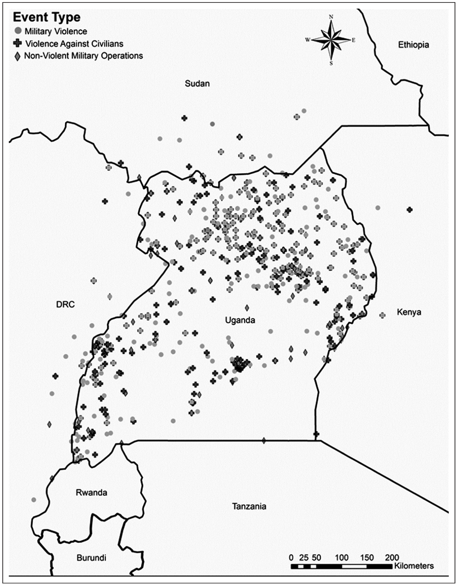
ACLED conflict events in Uganda, 1997–2011.
Descriptive statistics

Includes battles and violence against civilians.
Our precipitation data comes from the National Climatic Data Center’s Global Summary of the Day. 35 It comprises daily observations for land-based weather stations across the globe. We use all available observations from stations in Uganda, as well as nearby stations in surrounding states. In total, there are 19 weather stations providing information. For days with no recorded weather data, we generate values using a weighted average of the nearest real data. 36 From these we produce a full set of daily observations using an inverse distance weighting (IDW) interpolation method. 37 A sample day from our dataset, along with the weather station data points used in its creation, is shown in Figure 2. To test our second and third hypotheses, regarding the possible displacement of conflict events by precipitation, we construct measures of total precipitation over the previous and future 5 days. Given the often pressing nature of these largely small-scale events, a 5 day construction of previous precipitation should approximate, in particular given the poor transportation system, the effects of recent precipitation on military operations. Similarly, we use the next 5 days’ precipitation to capture the actors’ beliefs about upcoming weather. 38 Given the limitations inherent in weather prediction and the potentially varied access to weather forecasting technology and communications, this should approximate the actors’ average beliefs about the likelihood of future inclement weather, its severity, especially for multiple day storms, and its effects on operations. 39
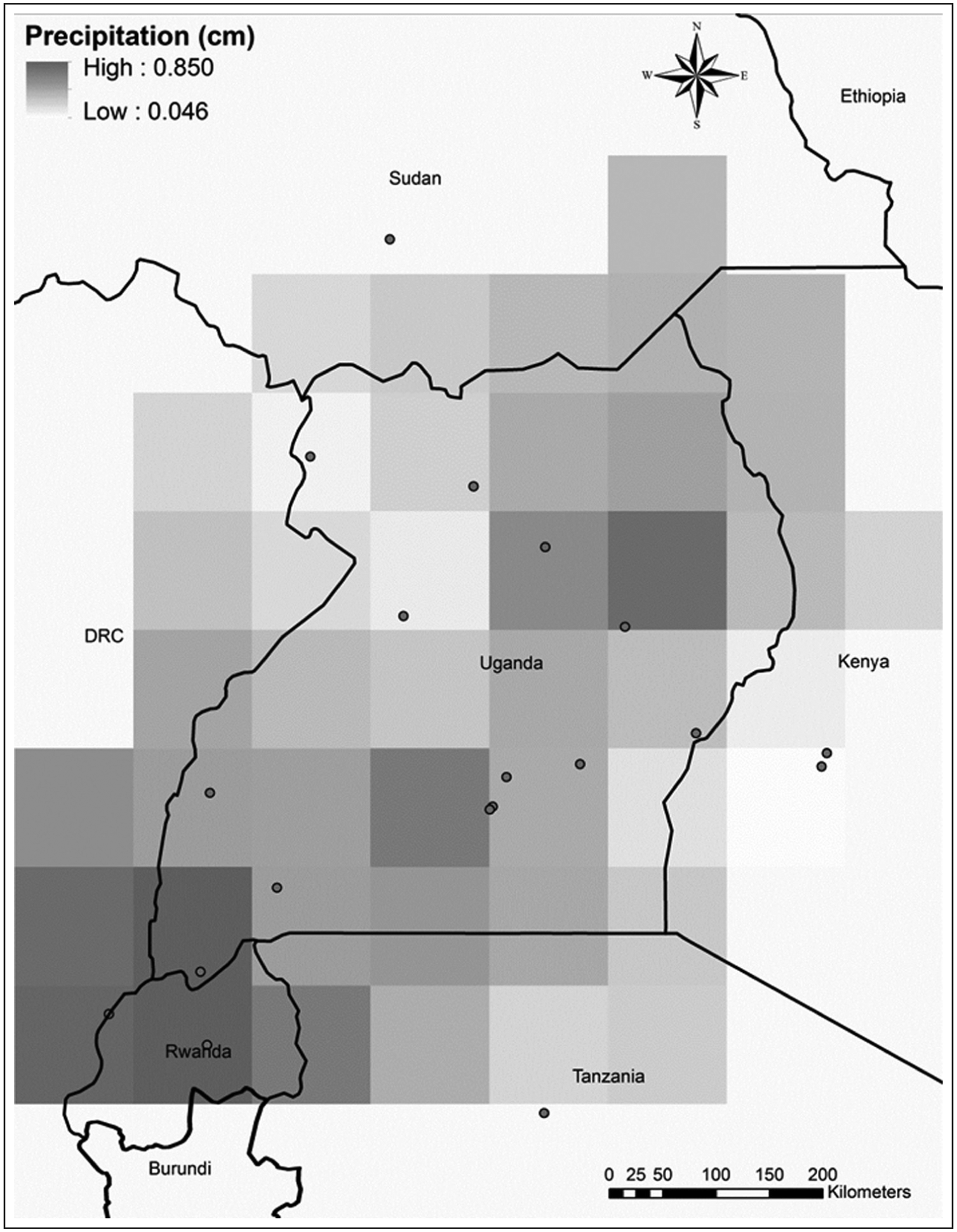
Weather station location and grid cell interpolation points.
Additionally, we include several measures of physical geography, including seasonal rainfall, difficult terrain, forests and water coverage. Recent research, discussed above, has focused on the climatic influences, often rainfall, on conflict. To control for the possible effect of seasonal levels of precipitation, we include a measure of average monthly rainfall. For this we use a long-term monthly average for all of Uganda from 1990 to 2009. The data come from the Climatic Research Unit at the University of East Anglia (World Bank, 2013). 40
Some research has found a relationship between mountainous terrain and conflict (Buhaug and Lujala, 2005; Rustad et al., 2008). While the terrain within Uganda is generally low-lying, between 600 and 1200 m above sea level, there is some variation in elevation around its borders. This includes two small mountainous regions that extend upward to 3600 m. The measure of difficult terrain we include is the standard deviation of elevation points within each grid cell. Instead of simply using maximum elevation, which would fail to distinguish elevated plateaus from more difficult mountainous terrain, this construction should better capture the ruggedness of the terrain. Elevation data come from the Environmental Systems Research Institute’s (2012) World Contours dataset. 41
We include a variable for percentage forest cover in each cell. Forest cover is among the elements of physical geography sometimes found to affect conflict (Buhaug and Lujala, 2005; Lujala, 2010). Similar to rough terrain, forested terrain is often theorized to advantage insurgents by hiding bases and concealing troop movements (Buhaug et al., 2009). Further, we control for the percentage of water cover in each cell. Lake Victoria, in the southeastern part of Uganda, accounts for the majority of the water coverage in the study area, along with lakes Albert, Edward and Kyoga. As none of the principal actors in the Ugandan conflict have meaningful naval capabilities, grid cells with more water should see fewer events. Forest and water coverage data come from the World Wildlife Fund Terrestrial Ecoregions dataset (Olson et al., 2001). 42
Roads also may affect the likelihood of conflict events (Zhukov, 2012). Areas with more roads are both more likely to have nearby population centers and more likely to be used for military transport. Our variable measures the total length of roads, including paved and dirt roads accessible by vehicle, in each grid cell. Although the variable is not time-varying, road density in African states has been shown to be relatively constant over time (Herbst, 2000). Road data come from the US Defense Mapping Agency’s Digital Chart of the World Database (1993). 43 We also control for the total population in each cell. 44 We use data from 1995, 2000, 2005 and 2010 to create one time-varying measure. Population data come from the Gridded Population of the World (version 3) dataset (Tobler et al., 1995).
Finally, a number of studies have found a relationship between ethnicity and violence in war (Cederman et al., 2010; Wimmer et al., 2009). As such, we include a control for the Acholi ethnic group. The Acholi have been important to the conflict at several points, first as a marginalized group with a grievance against the government and then as victims of LRA violence. Also, the LRA drew much of its support from the Acholi in the early years of the conflict and continued to recruit from and loot Acholi settlements even after support diminished. Consequently, areas with a greater Acholi presence may see a greater risk of violence. We construct a measure for the ratio of Acholi to other ethnic groups in each cell. The Acholi are mostly found in northern Uganda and 12 grid cells have an Acholi presence. Ethnicity data come from the PRIO Geo-EPR (version 2) dataset. 45
Research methodology
Our dependent variable, the presence or absence of a conflict event, is recorded at the daily, grid-cell level. Given the dichotomous nature of our dependent variable, we estimate a set of logistic models. There are, however, a very large number of zeros relative to events. As such, standard logistic models may be inappropriate: they may produce biased coefficient estimates and underestimate the probability of the relatively rare conflict events (King and Zeng, 2001). To address this, we instead estimate a set of rare event logistic models.
Additional complications may arise from the time-series, cross-sectional nature of our data. First, the independence within the spatial unit assumed by the logistic model is likely to be violated. One approach to addressing this temporal non-independence has been to follow the method developed by Carter and Signorino (2010). Their cubic polynomial approach addresses the time dependence with the inclusion of an elapsed time variable, which counts the days since the last event, a squared version of that counter and a cubed version. 46 We follow their approach and include these three additional variables in each model. Second, as it is unlikely that events are independent of the number of previous events, we also include a count of the previous days with a conflict event, of the same type, within that grid-cell. Additionally, as the data may exhibit unobserved temporal heterogeneity, we include a series of yearly and monthly dichotomous variables.
Furthermore, there may be a neighborhood effect: the likelihood of an event in one place may be affected by the presence of nearby events. To address this possible spatial dependence, we include a one-period lagged count of nearby conflict events, those within a third-order neighborhood of each cell. This construction is similar to the neighborhood variables used in Hegre et al. (2009) and Theisen (2012). Finally, we estimate the models with robust standard errors with the clustering centered on the spatial component of the unit of analysis, the grid cell.
Results
Table 2 shows the results from our rare event logistic models. 47 The variables’ effects on the risk of conflict events are shown as coefficients and beneath each coefficient is its robust standard error. Present, past and future precipitation, the measures designed to test the three parts of our hydraulic argument, are listed first.
Rare event logistic analysis of Ugandan conflict events, 1997–2011
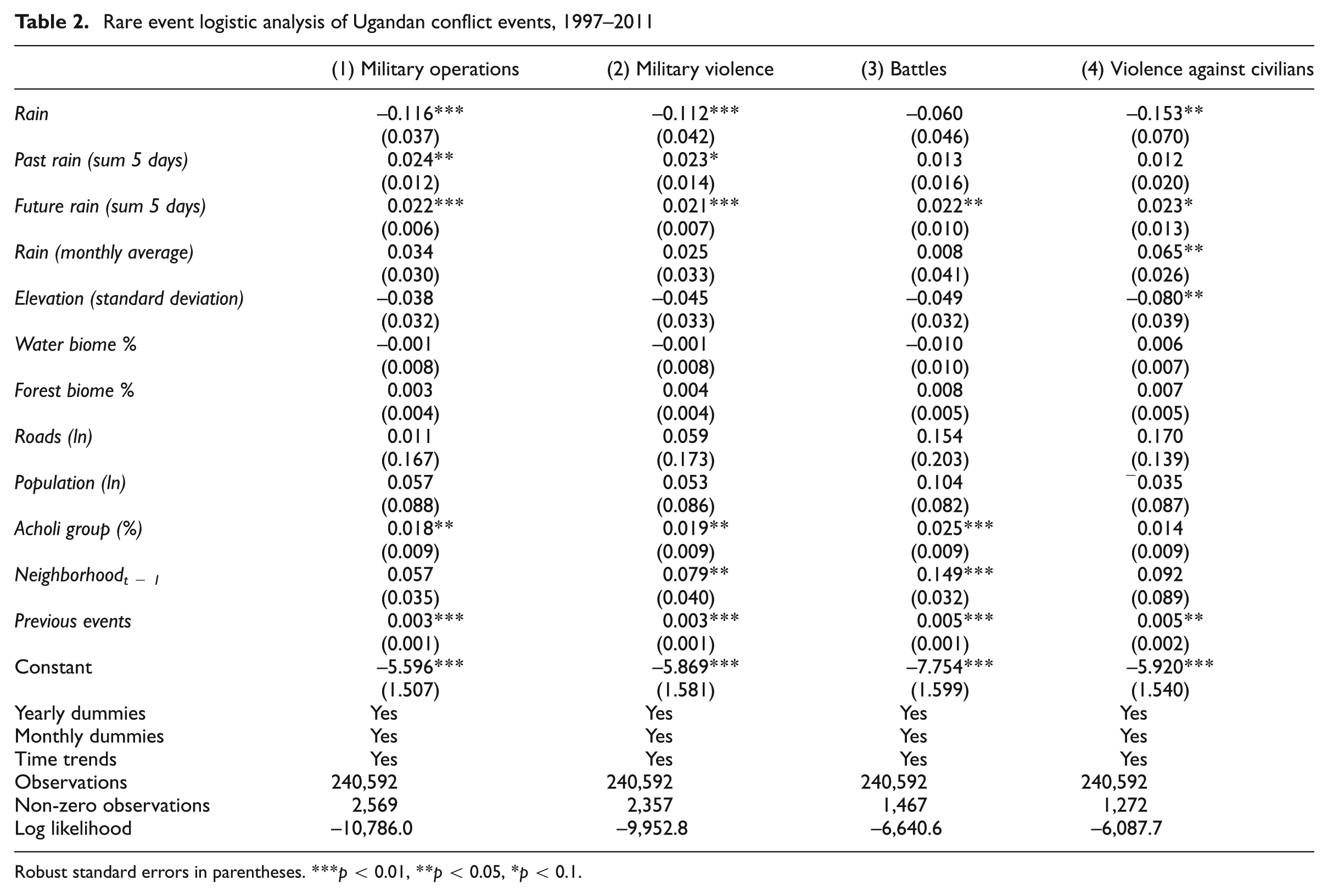
Robust standard errors in parentheses. ***p < 0.01, **p < 0.05, *p < 0.1.
To begin, we find significant and consistent evidence for our first hypothesis, that present-day precipitation reduces the likelihood of conflict events. We test this with four different groupings of our dependent variable. From left to right, these are (1) all military operations, (2) all military violence, both battles and violence against civilians, (3) only battles and (4) only violence against civilians. In the first two, present-day precipitation is consistently negative and statistically significant, with two-tailed p-values of 0.002 and 0.008. In the last two, where we separate the military violence into (3) battles and (4) violence against civilians, we see it remain in the predicted negative direction in each model. Again, present-day precipitation constrains conflict events, but it is only separately statistically significant, p = 0.030, in the violence against civilians model. Taken together, these four models provide considerable support for the hypothesis that present-day inclement weather limits military actors in the Ugandan conflict.
We also find considerable support for our second hypothesis, that recent precipitation increases the likelihood of present-day conflict events. We see that the sum of the previous 5 days’ precipitation increases the likelihood of conflict events today and is statistically significant, with two-tailed p-values of 0.046–0.091, in models 1 and 2. In these aggregated models, then, we find evidence that rain may compel belligerents to wait out inclement weather and postpone their military operations. When we separate military violence into (3) battles and (4) violence against civilians, recent precipitation loses its statistical significance in the disaggregated models. Its direction remains positive in both, but there is less evidence here than with present-day precipitation. That is, there is more evidence that military actions are constrained in the present than that they are postponed. This weaker evidence for postponing violence is not, however, surprising. As described earlier, especially in conflicts with poor roads and poorly mechanized forces, it is likely that transportation is made especially difficult in inclement weather and these deleterious effects may linger. Yesterday’s precipitation may not only constrain that day’s events but, to a degree, the following day’s as well since it may take more time for traveling conditions to improve. Consequently, the postponing effect from our hydraulic argument would need to be greater than any lingering limitation on transportation for this variable to be positive. As such, examining our hydraulic argument with this lagged measure of precipitation is the most demanding test for our argument, and, arguably, the positive findings for it may be viewed more strongly as evidence for our hydraulic argument.
Third, we find possibly the most support for our third hypothesis, that future precipitation increases the likelihood of present-day conflict events. Our forward-looking measure of precipitation, the sum of the next 5 days’ rainfall, increases the likelihood of conflict events today and is statistically significant across all four models, with two-tailed p-values ranging from 0.000 to 0.063. This anticipatory effect is more statistically significant in all four models than the relationship between lagged precipitation and conflict events. 48 Additionally, its effect is more significant than present-day precipitation in the first three models.
Taken together, our three sets of findings strongly suggest that military actors are constrained by time. They are not only moderately calculating, avoiding inopportune times for their violence, but they are also actively forward looking. 49 They plan and execute their strategies in a dynamic physical environment with inclement weather significantly driving their decisions. To summarize, our results provide considerable support for all three parts of our hydraulic argument: inclement weather constrains, postpones and hurries conflict events. 50
Conversely, we find considerably less evidence that conflict events are affected by other elements of physical geography. The other measures of physical geography are, with two partial exceptions, insignificant across all our models. Our measure of climatic rainfall, the monthly average measure, is positive across all four models but is only statistically significant, p = 0.011, in model (4), violence against civilians. These generally insignificant findings fit much of the conflict literature that fails to find a consistent relationship between climatic measures and conflict (Buhaug, 2010). Moreover, these findings are consistent with our argument that daily variation in rainfall affects the timing of violent events differently, and perhaps more strongly, than climatic measures.
Our measure of difficult terrain, the standard deviation of elevation points within a cell, is negative across all four models, but is only statistically significant, p = 0.040, in model (4), violence against civilians. We try other measures of rough terrain, including range in elevation and maximum elevation, and they are also always negative and generally insignificant. 51 These findings for difficult terrain’s relationship with conflict events correspond to recent research that has also failed to consistently find a positive connection between rough terrain and conflict events (see e.g. Buhaug and Rød, 2006; O’Loughlin et al., 2010a).
The last two measures of physical geography, forest and water cover, are both insignificant in all four models. As expected, water cover is negatively connected to conflict events in all but the last model, but in none of the models, with p-values ranging from 0.899 to 0.310, is it close to conventional significance levels. Alternatively, forest cover is consistently positive, but remains insignificant in all four models, although its p-values in models (3) and (4) are 0.106 and 0.145, respectively. These findings fit much of the literature that frequently fails to find evidence for a relationship between forest cover and conflict (Buhaug et al., 2009; Rustad et al., 2008). Taken together, these generally insignificant results for difficult terrain and the two biomes contrast with the consistently significant effects of precipitation and suggest, at least in the ongoing Ugandan conflict, that weather may play a more important role in conflict than other elements of physical geography.
We also find no evidence of a relationship between roads and conflict events. Its natural log is consistently positive, but insignificant, in each of the four models. Its p-values range from 0.220 to 0.949. 52 We also estimate the models with roads, not logged, and this is negative in models (1) and (2), positive in models (3) and (4), and also never significant. Its p-values range from 0.642 to 0.966. 53 We also fail to find evidence of a relationship between population and conflict events. The natural log of population is positively connected to the probability of a conflict event in the first three models, but none of these is significant with p-values of 0.206–0.543, and it is statistically insignificant, p=0.687, but negative in the last model. Population, not logged, is always positive but again never significant, with p-values ranging from 0.166 to 0.396. 54 The civil war literature is mixed with regard to the effect of population on conflict, with some studies suggesting that more populous areas should see more conflict events (Weidmann and Ward, 2010). Other studies have shown that, in relation to insurgent violence, the difference between urban and rural areas, in terms of population, is less important (McDougal, 2011). Similarly, we find that population matters little.
Outside of the precipitation measures used to test our hydraulic argument, the only generally significant standard variable is the Acholi ethnic group measure. This is positively connected with conflict events in all four models and, with p-values ranging from 0.004 to 0.044, is statistically significant in the first three. It is not statistically significant in model 4, violence against civilians, but it remains positive and its p-value is 0.102. As the Lord’s Resistance Army is largely made up of and operates near the Acholi people, this positive connection to conflict events is unsurprising. Similarly, scholars have frequently found that ethnicity is an important explanatory variable for conflict events at the micro level (Hegre et al., 2009).
The third-order neighborhood measure is consistently positive in all four models and significant in models (3) and (4), with p-values of 0.046 and 0.000, and is nearly significant, with a p-value of 0.108, in model (1). Thus, there is some evidence that conflict intensity in neighboring cells increases the likelihood of conflict events. We also estimate the models with first-, second- and fourth-order neighborhood constructions, and these produce similar results. 55 Additionally, the count of previous same-type conflict events is positive and statistically significant in all four models. 56 Past conflict events are positively linked to conflict events today. Not shown, but included in each model, are the three time trend terms discussed above. All of these are statistically significant and positive in each of the four models, suggesting that the observations are not temporally independent within each grid cell. 57
Conclusion and future research
In this paper we present an argument for the possible hydraulic relationship between inclement weather and violence in war, and using the ongoing Ugandan conflict, we find significant evidence for such a relationship. Our study suggests that conflict actors are aware of time pressure, the temporal constraints on their actions, and adjust their planning to take advantage of a continually changing military landscape. These findings contribute to the literature seeking to link climate, weather and violence by showing that weather affects the dynamics of conflict violence in addition to any broader effects on actor motivation and conflict initiation often debated elsewhere in the literature. Our findings also further the understanding of the temporal distribution of conflict events. As the timing of violence is important, the failure to observe these micro-level dynamics may produce incomplete, if not flawed, policy and military strategy recommendations. Overall, these findings provide a more complete explanation of the timing of events in conflict and may allow for better predictions of the occurrence of violence at the daily level.
More particularly, we find strong evidence that conflict actors condition their actions on precipitation, and that precipitation displaces violence within relatively short temporal boundaries. Within these periods, today’s precipitation serves to increase the pressure for militaries to act on nearby days, similar to how pressure behaves in a physical hydraulic system. That is, present-day precipitation limits conflict events, but the reduction is temporary. Past precipitation is connected to increased present-day events. Similarly, future precipitation, our proxy for its expectation, is also connected to increased present-day events. These findings are, in large part, robust across a number of specifications and types of conflict events.
Further, by finding evidence of displacement, but not necessarily an increase or decrease in conflict events, we make progress toward explaining the contradictory findings regarding a relationship between conflict events and weather at the micro and macro temporal levels. This finding also speaks to the benefits of our disaggregated approach. Similar to the recent movement towards spatial disaggregation in the conflict literature, our analysis also disaggregates space but goes further to disaggregate time. At a more aggregate level, our results would have been undetectable. This suggests that future research at the daily or finer level may also uncover previously unexplained relationships.
Although our evidence for a hydraulic relationship between precipitation and conflict events is strong, there are reasons to be careful in assessing our findings. We examine only one case over a relatively short time, and it may be unlike other conflicts. As such, generalizations beyond the ongoing conflict in Uganda should be limited. In particular, where technological differentiation between the combatants is large and inclement weather significantly advantages one side, the strategy of military timing may be considerably different. Additionally, it is possible that the timing of military actions in the early stages of conflicts may differ from the timing of events in ongoing conflicts.
Finally, the significant evidence for a hydraulic relationship between one component of weather and wartime violence suggests the possibility of other hydraulic relationships in war. As mentioned, studies of conflict generally ignore the possibility of hydraulic relationships. Potentially, however, there may be other, as yet unexamined, hydraulic relationships. They may operate across space or, as we find here, across time. The further study of these relationships may yield additional insight into the distribution of events in war and the behavior of military actors and open a variety of new avenues for conflict research.
Footnotes
Acknowledgements
The authors would like to thank Paul Hensel and Camber Warren for helpful comments on previous drafts and our anonymous reviewers and the editor for their valuable suggestions. Previous versions of this paper were presented at the Midwest Political Science Association, Peace Science, and International Studies Association (Midwest) annual conferences.
Funding
This research received no specific grant from any funding agency in the public, commercial or not-for-profit sectors.