



Abstract
This essay examines the Promenade Plantée in the context of the broader effort to remake Paris for a Postindustrial Age. It traces the political, social, and economic forces that shaped the Promenade’s architectonic form over time, from the production of a national rail system in the nineteenth century to the decline and dereliction of rail lines after World War II, to the reformatting of disused infrastructure in the 1970s and 1980s. Finally, the essay considers the mix of public and private interests that shaped the project’s design, adaptation, and use within the large-scale redevelopment of Eastern Paris.
Keywords
The old Paris is no more (the form of a city changes faster, alas! than a mortal’s heart).
Amid the grandeur of Paris, a disused freight railway lay fixed to the landscape, an obdurate reminder of the city’s industrial past. Elevated by an austere stone viaduct, the railway defines an urban typology common to many cities—a corridor that both cuts through the landscape and hovers above the level of the street. Once abandoned, the corridor now thrives in its repurposed form as part of a 4.7-km linear urban park, the Promenade Plantée (Figure 1). The superstructure that elevates a portion of the Promenade has been converted into the Viaduc des Arts, with dozens of high-end artisanal shops, boutiques, and cafés built into the great stone arches. Remarkably successful, the Promenade Plantée and Viaduc des Arts have proven catalytic for the transplantation of this adaptive reuse strategy, as cities around the world look to their own discarded railways as resources for urban regeneration.
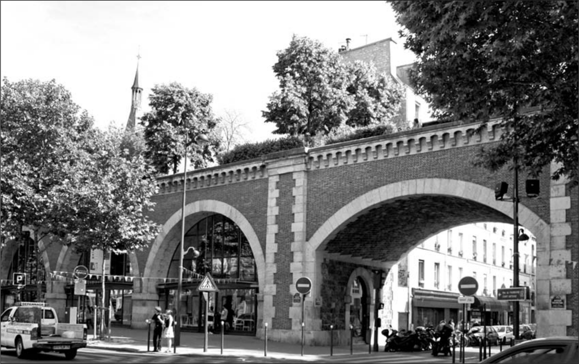
The Promenade Plantée, 2010.
As this redevelopment approach spreads to other cities, however, it is important to take a closer look at the project that spurred the trend. The present essay examines the Promenade Plantée in the context of the broader effort to remake Paris for a Postindustrial Age. It traces the political, social, and economic forces that shaped the Promenade’s architectonic form over time, from the production of a national rail system in the nineteenth century to the decline and dereliction of rail lines after World War II, to the reformatting of disused infrastructure in the 1970s and 1980s. Finally, the essay considers the mix of public and private interests that shaped the project’s design, adaptation, and use within the redevelopment of Eastern Paris.
Postindustrial Urbanism
The conversion of disused urban rail lines to linear parks has sparked the imagination of planners, designers, and citizens in many cities. The most complete adoption of this strategy to date is the High Line in New York City (David and Hammond 2011). But other cities are taking a close look at their relict transit infrastructure with an eye toward conversion, including Vancouver’s Port Mann Bridge, Philadelphia’s Reading Viaduct, the Sydney Monorail, Bloomingdale Freight Line in Chicago, and the Tanjong Pagar and Jurong Railways in Singapore. Indeed, there exists a surplus of vacated rail corridors—elevated or otherwise—in many countries around the world. These vacated lines obdure as part of a broader process of capital disinvestment, where tens of thousands of industrial age artifacts have fallen into obsolescence and disuse, particularly in former manufacturing regions of the United States and Europe (Brown 2001; De Sousa 2002, 297–309; Koekebakker 2004). Many of these structures are too expensive to tear down, so they decline in situ, accumulating the patina of age and abandonment as well as the antique allure of ruins (Edensor 2005; Santora 2010, RE1).
The Promenade Plantée reflects the production of new urban imaginaries in the context of late capitalism (Zukin 1993; Kirkwood 2001; Couch, Frazer, and Percy 2003). Dramatic shifts in the global economy since World War II reconfigured the location of capital, investment, and production. Initially, these shifts buoyed the French economy, and Paris enjoyed les trente glorieuses (“the glorious thirty”)—a period of high wages and employment, abundant and cheap consumer goods, and an extensive social welfare state. Nevertheless, the investments of capital and flows of wealth during this period were uneven. Most of the resources of the redistributionist state flowed in the form of social programs in health, education, pensions, and price supports. Large-scale investments in the built environment, on the other hand, tended to favor the construction of massive new cultural facilities in the urban core along with housing complexes on the periphery (Lacaze 1993; Clift 2009; Thody 1998; Urban 2011, 37–49). As a result, many French industrial cities experienced substantial disinvestment and deferred maintenance—particularly in aging factories, ports, warehouses, bridges, and urban core neighborhoods. At the same time, beginning in the 1970s, the vacated structures of the industrial age formed an increasing part of a transnational conversation about the relationship between heritage, environment, and urban regeneration (Spirn 1985; Farr 2007). And throughout the 1980s and 1990s, politicians, planners, and residents of Eastern Paris engaged in sporadic debates over the terms of urban redevelopment, grounded in competing technical, economic, and ideological visions.
Paris Governance and Planning
The role of municipal government in the remaking of urban spaces such as the Promenade Plantée has undergone considerable transition since World War II. Prior to the war, Parisian planners working under the auspices of the Prefecture of the Seine expended most of their time and energies in the episodic clearance of the îlots insalubres (slum quarters). In the first decade following the war, however, the severe housing crisis constituted the central planning challenge (Wakeman 2009, 131–42). As a response, planners shifted efforts away from central city demolition and toward higher-density construction on the urban periphery. The 1955 urban renewal law empowered the Municipal Council to declare swaths of the city to be mal utilisé, which in turn enabled the Prefect’s services techniques (planning staff) to redevelop the areas for ‘higher and better’ uses (Evenson 1979, 285–87). Underused or poorly used areas, according to planners, included aging warehouse and factory districts, declining port facilities and quays, and peripheral residential quarters with low population densities.
Deploying the new law, planners transformed the low-density ring alongside the Boulevard Périphérique into a series of Modernist residential and commercial environments. Many of these peripheral projects comprised social housing blocks, while others, such as the redevelopment of the Place d’Italie, created entire new high-density middle-class districts (Figure 2).

Place d’Italie, c. 1966.
In addition to the peripheral projects, planners also inserted several similar developments into the fabric of the central city itself—including the oft-reviled Tour and Gare de Montparnasse and the Front de Seine (Sutcliffe 1996, 165–69). Between 1954 and 1974, redevelopment activities reshaped 12 square kilometers of land across Paris—nearly a quarter of the city’s buildable surface. But it was not simply the quantity or extent of the changes that transformed Paris. Planners reconfigured the quality of land uses as well, eliminating 28 percent of all industrial floor space while adding 22 and 16 percent more office and residential space, respectively, in the process (Evenson 1979, 310).
The efforts of planners through the 1950s and 1960s to decentralize the urban core culminated in the 1965 regional plan for Paris: the Schéma directeur d’aménagement et d’urbanisme de la région de Paris. 1 However, even as officials rolled out the plan, Parisians began agitating against the excesses of redevelopment, opposing what many saw to be the sapping of vitality of the old city. Spurred along by the massive student and worker unrest of 1968, citizens mobilized to oppose the ongoing demolition and rebuilding of urban districts. The Prefect of the Seine countered that “Paris cannot, without irremediably impoverishing itself, dwell in a morose contemplation of its past” (quoted in Evenson 1979, 295). But critics increasingly lamented the loss of small commercial and artisanal activity that had long made Paris so vital, and working-class residents began to agitate against the continual dislocations they experienced as factories, warehouses, and so-called mal utilisé residential districts fell to the wrecking ball (Evenson 1979, 303–4).
With the resurrection of the Paris mayoralty in 1976, the energies of redevelopment shifted from the Prefecture to the new municipal executive. Leading a resurgent right wing in Parisian politics (and advantaging a divided left), Jacques Chirac and his party Rassemblement pour la République (RPR) won the first mayoral election in 1977. Chirac and his successor Jacques Tiberi practiced a modified form of dirigisme, shifting the locus of urban redevelopment from central state authority to public–private partnerships. Their devolutionary efforts dovetailed with the broader neoliberalization of governance and finance in Western Europe, where state expenditures have been reprioritized from the central redistributive model of transfer payment to the decentralized investment model of infrastructure-led redevelopment (Swyngedouw, Moulaert, and Rodríguez 2003). Nevertheless, Chirac’s neoliberal dirigisme was fully pro-Paris, a reaction to what officials saw as the delegitimization of Paris within the larger regional plans of the 1960s. For Chirac, the restoration of the mayoralty was akin to the restoration of Paris’s place on the national and world stage (Goudeau 1977).
Chirac’s ambitions received a considerable boost, ironically, with the election in 1982 of Socialist President François Mitterrand. Despite their political differences, the two agreed on the unquestionable primacy of Paris, particularly as France looked forward to its Bicentennial in 1989. Shortly following his election, Mitterrand announced his Grandes Operations d’Architecture et d’Urbanisme or Grands Projets, a series of major developments that would bring new monumental grandeur to Paris, including the Bibliothèque Nationale de France, the Grande Arche de La Défense, and the Opéra Bastille. This national command economy of cultural production dovetailed with Chirac’s goals to liberalize property control laws and to use infrastructure and facilities to increase property values in Paris’s residential districts (Bacqué et al. 2011, 256–73; Carpenter and Lees 1995, 295).
Meanwhile, the mayor’s office retained the primary right and responsibility for land use planning through its Atelier Parisien d’urbanisme, created in 1977. Much of the large-scale planning activity in Paris revolved around redevelopment geographies called zones d’aménagement concerté (ZAC), where planners sought to leverage private investments through intensive public capital expenditures on demolition, site preparation, utilities, and infrastructure. A major overhaul of planning laws in 1983 enabled the establishment of new entities to carry out the city’s various plans: the Sociétés d’Economie Mixte (SEM) (Marvillet 2006, 49–51). As state-chartered municipal corporations, the SEM bring together public and private interests into bargaining relationships to execute projects within the ZACs. While quasi-public, the SEM remain heavily controlled by the mayor’s office, and retain significant power to bargain with private interests over the fate of urban space (Nelson 2001, 292–98). One of these entities, the Société d’économie mixte d’aménagement de l’Est Parisien (SEMAEST), would act as lead developer for a range of ZAC projects under the aegis of the Plan-programme Est de Paris, approved by the municipal council in November 1983 (SEMAEST 2005). The aim of the Plan-programme, as its title suggests, was no less than the transformation of eastern Paris over the next two decades, including the creation of new green spaces such as the Promenade Plantée (Varlet 1997, 79).
From Industrial Machine to Green Corridor
The transformation of the disused rail line into the Promenade Plantée and Viaduc des Arts grew out of the broader effort to convert the Right Bank of Eastern Paris from a working-class industrial landscape to a high-end district populated by upwardly mobile professionals. Completed in 1859, the Bastille–Vincennes line provided the urban connector to the long-haul Paris and Strasbourg railroad (Figure 3). Its construction reflected the authoritarian growth policies of the Second Empire government, focused on the rapid industrialization of France (Green 2011, 35–38, 57–64; Nilsen 2008, 69–72; Price 2007, 210–15).

Gare de Reuilly, c. 1910.
Overseen by Prefect of the Seine Georges-Eugène Haussmann, the construction of the viaduct embodied the ruthlessly technocratic ethos of modern civil engineering—what Haussmann himself called “the implacable access of the straight line”—slicing its way across the streets and neighborhoods of the Twelfth Arrondissement in order to network Paris with the nation (Jordan 1996, 185–87). With the creation of the state-owned Société Nationale des Chemins de fer Français (SNCF) in 1938, the Paris–Vincennes–Strasbourg line was absorbed into the public rail system (Nilsen 2008, 109–11).
After World War II, Paris’s nineteenth-century industrial infrastructure went through a wrenching process of “unbundling” and “rebundling,” as planners recalibrated the varied portfolios and asset classes of urban utility amid transformations of capital (Graham and Marvin 2007, 137–65). The shift to truck-and-trailer freight distribution, for example, resulted in the construction of new terminals around the suburban periphery, in turn forcing many rail corridors into decline. This exposed the “fragility” of modern infrastructural landscapes like the Bastille–Vincennes railway (Soppelsa 2009, 233–34). The final blow came with the construction of the Réseau Express Régional (RER) passenger system beginning in the mid-1960s. The RER A rendered several older rail lines redundant, and in 1969 officials finally decommissioned the Bastille–Vincennes railway (Meunier 2001, 22–41, 56–70). Even as the RER A became one of the busiest commuter lines in the world, the Bastille–Vincennes portion in the inner urban core remained disused, a neglected piece of French industrial heritage.
As early as the 1970s, adventurous Parisians had quietly laid claim to the vacated viaduct as a kind of insurgent habitat. The abandoned rail bed became a haven for bird watchers, underage drinkers, drug dealers, and urban explorers. At the same time, enterprising Parisians established numerous makeshift auto repair shops, studios, brasseries, and squats under the arches of the viaduct (Figure 4) (Meade 1996, 52).

The viaduct before redevelopment, taken at the Rue de Lyon looking Northwest toward the Place de la Bastille, 1978.
But many residents of the Twelfth Arrondissement grew tired of living alongside an abandoned rail line, and began agitating for a solution. Some residents and officials wanted the railway torn down. Others called for the development of a new commuter line, or even the restoration of freight service.
Beginning in 1978, the Atelier Parisien d’urbanisme began to move forward with large-scale plans for Eastern Paris. The plans included both the Twelfth and Thirteenth Arrondissements straddling the banks of the Seine. On the Right Bank, the plans centered on efforts to remake the districts around the Gare de Lyon, and to support one of Mitterrand’s key Grands Projets: the construction of a new Opera house at Place de la Bastille (Fachard 1987; Chaslin 1998). The plans also incorporated several extant ZAC sites scattered through the Twelfth, including the ZAC Bercy, ZAC Chalon, and most dramatically the ZAC Reuilly (see map, Figure 6). The ZAC Reuilly comprised the now decommissioned SNCF rail yards, a twelve-hectare triangular site bounded by the Avenue Daumesnil, the Rue de Reuilly, and the Rue Montgallet. The site included the Bastille–Vincennes rail line, the Gare de Reuilly (Figure 3), as well as numerous warehouses, equipment sheds, and rail spurs for loading and storing the rolling stock.
Meanwhile, throughout the 1970s and 1980s, state-directed planning schemes encountered a citizenry increasingly traumatized by the destruction of major Parisian landmarks. Citizen opposition emerged from a mix of motives, including newfound environmental consciousness, anti-establishment politics, and nostalgia for a partly imagined precapitalist Paris of artisans, shopkeepers, and petit quartiers (Figure 5) 2 .

Hardware store on Avenue Daumesnil, across from the viaduct in the Twelfth Arrondissement, 1981.
Frustrated by the focus on grandiose megaprojects and lack of green space in the city’s redevelopment schemes, residents of the Twelfth pushed officials to rethink the clean-slate urban renewal approach. The Atelier d’urbanisme proved receptive, particularly as it had begun to emphasize green space as part of the broader rebalancing of amenities and cultural features between Western and Eastern Paris (Meade 1996, 52). Given the Bastille–Vincennes rail line’s historic prominence and the dire need for new green space in the city, the idea to convert it to a public park garnered support from a wide range of government, nonprofit, and business interests.
With the creation of SEMAEST in 1983, a new group of planners took the opportunity to reconceptualize the ZAC Reuilly within the broader Plan-programme Est de Paris. Most importantly, they embraced the idea to convert the Bastille–Vincennes rail line into a linear greenway for the city, rather than following the original plan to cover it with new construction. Thus, when the Atelier unveiled its new general scheme for the Bastille railway in 1985, SEMAEST planners were already prepared to link the Promenade to the existing ZACs and ultimately to the transformation of Eastern Paris (SEMAEST 2005). As a result, plans for new residential and commercial development in the ZAC Reuilly took shape around the design of the greenway, the restoration of the Gare de Reuilly, and the creation of the new Jardin de Reuilly to serve as the central pivot point of the Promenade Plantée (Varlet 1997, 78–84). The hugely successful transformation of the Gare d’Orsay into a museum (1979–1986) further emboldened planners to experiment with the adaptive reuse of aging industrial infrastructure, and to move ahead with the Promenade Plantée and Viaduc des Arts (Lowe 1996, 96–104).
Seeking the best plans for the new greenway, SEMAEST held a design competition in 1988, and awarded contracts to three finalists. Architect Patrick Berger would act as lead designer, and would oversee the redevelopment of the superstructure, with its seventy-one arches, into the Viaduc des Arts. Architect Philippe Matthieu and landscape architect Jacques Vergely would design the new greenway on either side of the ZAC Reuilly. Berger, Matthieu and Vergely were already part of a robust renaissance of urban park and landscape design in France spurred on by preparations for the National Bicentennial (Hunt 2002, 203–5; Melbourne Proceedings 2010, 592). Berger’s plans for the Paris-Citroën-Cévennes Park, launched in 1985 in affluent Western Paris, had already attracted international attention, adding momentum to efforts around the Promenade and to the imperative for extending the park renaissance eastward (Hucliez 2007, 44–49).
Repurposing Space, Remaking Place
The Promenade Plantée stretches for 4.7 km through eastern Paris, defining a linear condition in changing elevation that connects the Place de la Bastille with the Bois de Vincennes on the city’s periphery (Marvillet 2006, 57). Along the route, it transects the four quartiers that comprise the Twelfth Arrondissement: Quinze-Vingts, Bercy, Picpus, and Bel Air (Figure 6).
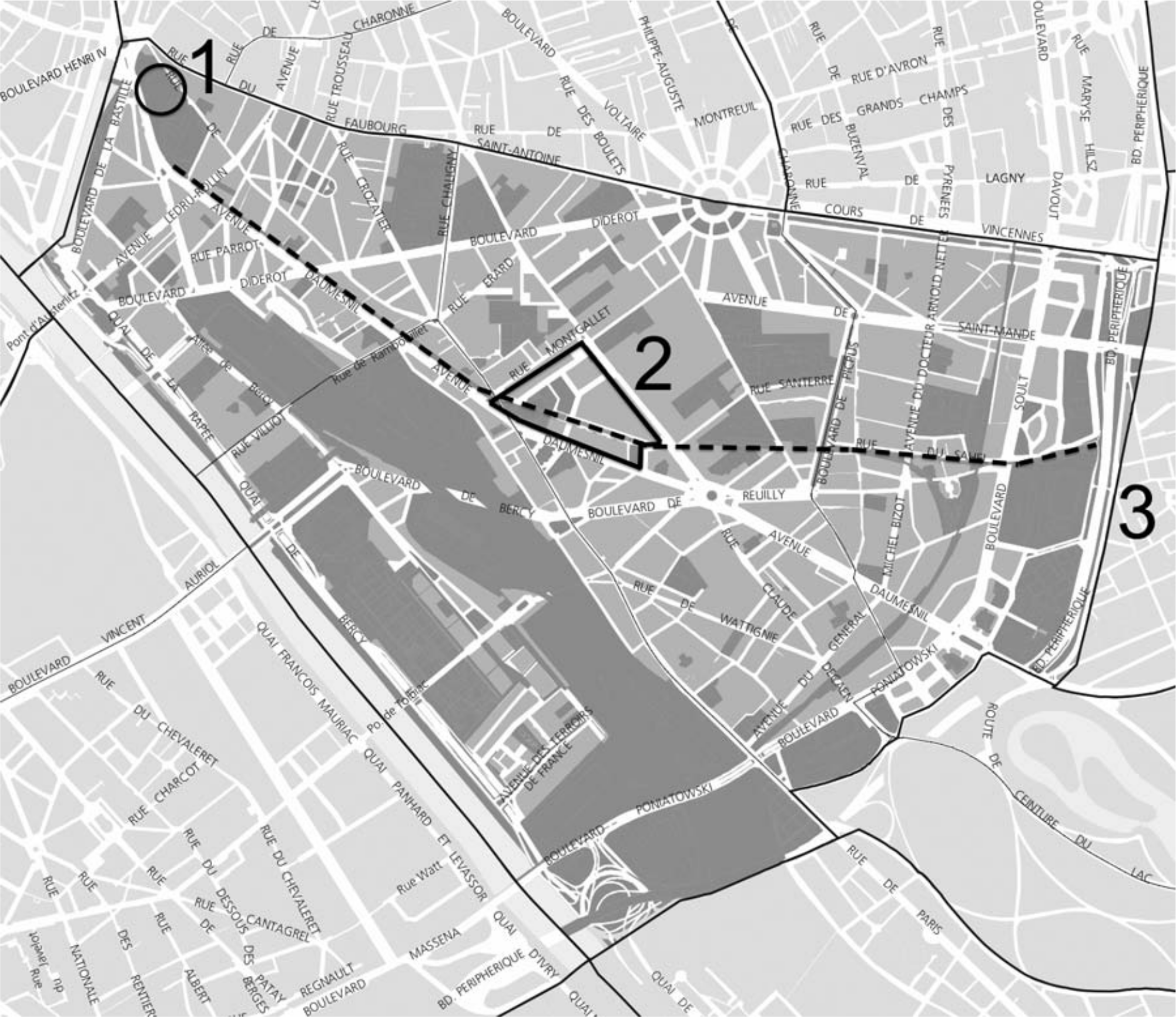
The Promenade Plantée route (dotted line) through the Twelfth Arrondissement, showing (1) the Opéra, (2) the ZAC Reuilly boundaries, and (3) the Boulevard Périphérique.
The Promenade commences approximately 365 meters southeast of the Opéra Bastille, at the point where the Bastille-Vincennes spur (and thus the greater Paris–Strasbourg line) once terminated. For the first 1.5 km, it runs atop the Viaduc des Arts, stretching eastward along the Avenue Daumesnil through the Quinze-Vingts quarter. From the Quinze-Vingts, the elevated Promenade crosses the Rue de Rambouillet into the northern tip of the Bercy quarter, an old warehouse district near the Seine. While still elevated, the line shifts here from the exposed stone viaduct to a series of bridges, platforms, and earthen embankments, often secreted from the street.
After Bercy, the Promenade takes its longest stretch through the Picpus quarter. Midway through Picpus, the elevated portion terminates at the Jardin de Reuilly, a park converted from the railway’s maintenance yard. Promenaders can pass over the park across a long, narrow wooden footbridge, or meander through the park along its perimeter paths. After Reuilly, the Promenade runs either at or below the grade of the street until it passes through a tunnel under the Boulevard Périphérique, through the suburb of Saint-Mandé, eventually connecting to the Bois de Vincennes.
The design team of Berger, Matthieu, and Vergely organized the Promenade Plantée to open in three phases between 1988 and 1994. In Phase I, Matthieu and Vergeley designed and executed the landscape program for the Western, elevated portion of the Promenade, which constitutes more than one-third of the entire length of the greenway. In Phase II, Berger directed the restoration of the viaduct to create the Viaduc des Arts. Finally, in Phase III, the design team articulated the Promenade with the ongoing redevelopment of the ZAC Reuilly site, and extended the greenway Eastward to its terminus. Matthieu and Vergely configured the rail bed into a classic linear promenade with plantings, benches, pergolas, and arbors. They devised a succession of pauses where the plantation recedes and space is given over to small ponds, plazas, niches, and furniture for lingering. For the Jardin de Reuilly, SEMAEST relied on Pierre Colboc, lead architect for the ZAC Reuilly redevelopment site. Colboc retained the semicircular form created by the bend of the rail corridor as it parallels the Avenue Daumesnil and opens into the old SNCF rail yard, using this dramatic shape and panoramic condition to describe the park space (Figure 7).

Suspension footbridge carrying the Promenade over the Jardin de Reuilly, 2011.
Beneath the rail line’s elevated portion, the Viaduc des Arts presents a uniform configuration of the spaces defined by the seventy-one grand arches. Prior to redevelopment, many of the vaulted spaces housed one-and-a-half story premises with businesses on the street level and small lofts above for storage and illegal flats, all enclosed by makeshift façades that had accumulated over time (see Figure 4). In the renovation process, these premises were demolished and cleared out, opening up the arches to their original condition. While eleven of the arches remain open for street through-traffic, the other sixty have been equipped with uniform glass curtain-wall façades and regulated signage, color schemes, and uses. These open, airy commercial premises house boutique craft and artisanal operations, restaurants, and design firms. From the moment it opened, the Viaduc des Arts and the Promenade Plantée enjoyed critical and popular success. 3
Today the Promenade Plantée runs through the Right Bank of Eastern Paris, conducting the walker along a height that varies from two stories above the street to ground level. The running elevation provokes a wholly new experience of the city, what might be called an elevated urbanism. Hovering above the second stories, the promenade compels attention to the architecture—particularly to the details less obvious from the street. It places pedestrians in an equal relationship with buildings, gazing across their bulk rather than up to their verticality, taking in their lines and mass all at once (see Figure 8). The Promenade passes above or below twenty-one intersections, removing people from the constant presence of automobiles and street crossings. By repurposing the hardscape of old infrastructure, planners enable a soft mobility of nonmotorized traffic across a long stretch of the city (La Rocca 2010, 85–90). In this way, the Promenade defines a new urban condition, a linear envelope of architecture, ground, and sky that enhances people’s movement through space while catalyzing the emergence of place.

Rear of buildings at eye level on the Promenade, 2011.
The Promenade exemplifies the careful remaking of space into place. Though calm and serene today, the elevated railway was torn violently and methodically from the medieval fabric of the city that surrounded it (Lefebvre 1992, 169–73, 277–78). The rail line originated out of what Michel de Certeau has described as part “speculative dream” and part “gridwork of technocratic discipline,” a powerful set of nineteenth-century spatial-temporal processes that included fixed capital investment, industrial scale transport, infrastructure development, regulatory schedules of movement, and the build-out of the surrounding factories and workshops of the city (De Certeau 2011, 113; Sutcliffe 1996, 83–97). The line also formed an integral part of Napoleon III’s nation-building project, spatialized through the creation of rail corridors, urban linkages, and capacious rights-of-way that moved people, goods, and ideas throughout France at ever-greater speeds (Harvey 2005, 102–10; Sutcliffe 1996, 84–87). Long after its decommissioning, the railway continued to embody in its frozen form the propulsive and volcanic spatial-temporal practices that created it (Schivelbusch 1986).
The transformation of this legated space into a celebrated place called for architectonic imagination, ecological awareness, and social sensitivity. Designers Vergely and Matthieu conceptualized the overall plan of the Promenade within the French landscape practice of préverdissement—a term borrowed from horticulture that means to encourage a particular botanical scheme through initial plantation. In this practice, according to landscape architect Pierre Donadieu (1999, 14), designers aspire to “anticipate the city” through nimble, dynamic, and flexible tactics. Rather than overdetermining the urban landscape through close-ended constructions, designers organize reclamation and revitalization projects within a framework that connects current conditions to future growth, and that provides platforms for human drama and experimentation.
Ultimately to be successful, the Promenade needs the ongoing presence of people—their bodies, affects, trajectories, and memories. Human actions constitute the necessary, if not sufficient, condition for the conversion of space into place (Hayden 1997; Cresswell 2004, 29–42). The Promenade supports and benefits from a range of place-making routines, including walking, jogging, sitting, picnicking, bird watching, reading, talking, seeing, and being seen. It is an amenity for adjacent residents, a destination for Parisians, a draw for tourists, and a laboratory for horticulturalists and students of landscape. It offers a unique viewshed of Paris: originally constructed for motion, connection, and destination, it now frames a counteroptic of slowness, rest, and contemplation. Visitors absorb views not through the claustrophobic window of a moving train, but from the unencumbered vantage of the walker in the city, whose peripheral vision sweeps over building and sky. And unlike the grand boulevards designed by Haussmann as a theatrical set piece for a new Paris, the Promenade Plantée slices through the city’s back stage, revealing an alternate vantage from which to read and experience the landscape (Figure 8) (Sennett 1992, 133–37; Jordan 1996, 348–52).
All of this place-making activity unfolds along an interstitial seam several stories above the streets of Paris, and it is the conservation of this linear elevation that is the Promenade’s signal achievement. The Promenade retains the material culture of the industrial age in the form of the viaduct atop which it runs. It also secures the intangible heritage of the spatial corridor, the right-of-way of the rail line, originally appropriated at public expense for private use, now returned to the public as open access leisure space. To create such a corridor anew in today’s city would be nearly impossible. Moreover, the Promenade’s peculiar form—a long, thin spine with thick edges and complex program—produces a kind of folded, interiorized space that nevertheless feels capacious. It converts what had been an edge condition characterized by a rigid, impermeable boundary into a threshold for multiple activities, experiences, and meanings (Kullmann 2011, 70). In this way, the preservation of historic spatial elements has resulted in a new form—an elevated urbanism—that provides a rich platform for human dramas, actions, and public culture.
Politics and Placemaking
The creation of the Promenade Plantée and Viaduc des Arts from the disused Bastille-Vincennes rail line has catalyzed efforts in many cities to adapt obsolete rail infrastructure to new uses. As this public spatial typology spreads to other cities, however, it is worth considering the successes and challenges of the Promenade Plantée within the contexts of its creation and use. To be sure, the Promenade Plantée arose as a project of the French state with manifestly public benefit. Moreover, French cities, unlike their Anglo-American counterparts, typically contain higher proportions of wealthy households in central districts to begin with, and therefore experience gentrification in less rapid and glaring ways (Préteceille 2007, 10–31). Very few of the central and western beaux quartiers of Paris have witnessed the devaluation cycles of socioeconomically equivalent London and New York neighborhoods, for example. Still, sizable swaths of northern and eastern Paris saw declining property values in the decades after World War II, particularly in the 1960s and 1970s, followed by several stages of revaluation in the 1990s and 2000s. These cycles enveloped the Promenade Plantée and the Twelfth Arrondissement within a set of transformations in the nature and experience of city life in postindustrial Paris (Carpenter and Lees 1995, 292–95).
Thus, the Promenade Plantée emerged as just one part of a vast remaking of Northern and Eastern Paris over the 1980s and 1990s, with the primarily goal of the Chirac administration being the revaluation of private property values through targeted public investments (Donadieu 1999, 12; Nelson 2001, 492–98; Savitch and Kantor 2004, 145–47). Evidence suggests that the strategy has paid off, if unevenly, in many quarters of the city such as Montmartre, Porte Saint-Martin, Belleville, and the Marais, though less so in Pigalle and the Goute d’Or (Bacqué and Fijalkow 2006, 63–83; Pattaroni, Kaufmann, and Thomas 2012).
In the Twelfth Arrondissement, national census records reveal many of the telltale signatures of devaluation and revaluation cycles. Amid the severe housing crisis of the postwar decade, the vacancy rate in the Twelfth was less than one-half of 1 percent. From 1962 to 1975, however, the number of vacant units in the Twelfth nearly quintupled. By the end of the 1980s, 8 percent of the housing stock in the Twelfth lay vacant—a total of 6,316 units. The rise was even more dramatic in the 48th quarter, comprising the Quinze-Vingts neighborhood, which contains most of the elevated portion of the Bastille–Vincennes line. In 1990, more than 10 percent of housing units in the Quinze-Vingts were vacant. Not surprisingly, the Quinze-Vingts experienced a far more dramatic population decline than the city overall, losing 42 percent of its residents between 1954 and 1999, while the city lost 25 percent (Table 1).
Population of Paris, 1954–1999.

However, with new investments in the Promenade Plantée, Viaduc des Arts, the ZAC de Reuilly and Bercy, and housing rehabilitation, the vacancy rate in the Twelfth leveled off in the 1990s at around 8 percent. And the population of the Twelfth rebounded, experiencing a 5 percent growth rate since 1982, even while the city as a whole continued to lose population. In one sense, the neighborhood has turned an important corner (Atelier Parisien d’urbanisme 2005). 4
Nevertheless, as the vacancy rates leveled off, the population and employment base of the neighborhood underwent a substantial transition. This transition reflected, in part, broader changes in the political economy of France and the nature of work and residence in the nation’s capital city (Table 2).
Selected Employment Categories in Paris, 1982–1999.

In 1954, for example, one in six Parisians worked in traditional industrial and wage-earning jobs. By 1982, the proportion had fallen to one in ten, and by 1999 only 5.5 percent of all residents fell into the category of ouvriers. This transformation exerted the most dramatic effect on working- and lower-middle-class neighborhoods of Paris. The Twelfth Arrondissement, for example, saw a sharper decline than the city as a whole in the numbers of laborers, semiskilled tradespeople, clerks, food and commercial employees, low-level bureaucrats, and other wage and salary earners. Meanwhile, between 1982 and 1999, the Twelfth experienced a sharper rise than the city overall in the number of people employed in the knowledge professions. The Quinze-Vingts neighborhood (48th Quarter) experienced these changes most intensively, with a 120 percent rise in the proportion of knowledge industry professional—double the increase in Paris overall—and a 60 percent decline in the number of wage workers. It is likely that the creation of the Promenade Plantée and the Viaduc des Arts exerted a catalytic effect on the neighborhood, increasing property values and reconfiguring the residential landscape.
An in-depth regression and mapping study by Anne Clerval (2011) further details the picture. Centered on the old Faubourg St. Antoine, which includes parts of both the Eleventh and Twelfth Arrondissements east of the Bastille, Clerval’s research reveals that between 1982 and 1999, the neighborhood experienced a dramatic increase in the number of “high cultural capital” residents, and a corresponding decline in moderate-income households. These increases in households with both very high incomes (white collar workers in technology, finance, and management) and very low incomes (artists, students, and the déclassé) suggest a “hollowing out” of the middle—a common signature of gentrification. During the same period, Clerval demonstrates that as property values rise in the 1990s, working- and middle-class households began to move eastward toward the Boulevard Périphérique and beyond into the suburban banlieus. 5
The Promenade’s Viaduc des Arts, with its dozens of high-end artisanal shops and boutiques, constituted a central element of the commercial reconfiguration of East Paris. On the one hand, the outfitting of the Viaduc des Arts reflects the commitment by officials to support the traditional artisanal and craft operations that had long characterized the Twelfth Arrondissement. And yet planners cleared the ramshackle collection of small-scale, DIY artisanal workshops and squats that had accumulated beneath the arches, making way for the installation of premises geared toward “upmarket tenants, attracted by the upgrading—not to say gentrification—of the area stimulated by the Bastille Opera” (Meade 1996, 54). In the process, planners and designers imposed a derivative, unitary aesthetic of glass façades and open interiors on a structure whose former aesthetic derived from the rich, adaptive, and fine-grained accumulations emerging from the working-class neighborhoods of the Twelfth (see Figure 4). The effect of this transformation, as with so many postindustrial urban redevelopment schemes, has been to convert a site of primary production to a landscape emphasizing tourist spectatorship and consumption (Zukin 1993, 4–9; Clarke 2003, 28–43). Indeed, tourists “discovered” Eastern Paris as the neighborhood surfaced in the discursive space of travel magazines, books, and blogs throughout the 1980s and 1990s (Pinkhasov 2012).
Thus, the refurbishing of the Bastille neighborhood, construction of the new Opera house, and completion of the Promenade ushered in a process of transformation in Eastern Paris that continues today (Marvillet 2006, 35–42). More recently, however, the Sarkozy government reduced funding for the various Sociétés d’Economie Mixte. Over the past five years, SEMAEST and other quasi-public agencies have operated within significant budget constraints, under directives to seek more private sector investment and to streamline their operations along European development norms. These norms, established through the European Union, intersect in complex ways with national political cultures, state sectoral investment strategies, and local development cultures (Trache 2007, 170–74). It is yet unclear how the election of Socialist President François Hollande will affect these long-term shifts in the political economy of the city. Moreover, how such social and political realignments will shape the balance of public and private interests in Eastern Paris, or indeed whether large-scale infrastructure projects like the Promenade Plantée will even be possible in the future, remains to be seen.
Conclusion
In the end, whether the conversion of industrial artifacts produces narrow benefit or broad public good, the process inevitably monumentalizes a set of historical relationships while producing dramatic shifts in place association (Pollitt 2012, 65–73). Indeed, the Promenade Plantée comprises not one but several interlaced sociospatial modalities. Despite its unique prospect, for example, it is in many ways a classic Parisian bourgeois park, with its carefully crafted landscape and firmly controlled optics—a linear pathway for seeing and being seen. At the same time, it is a neoliberal adventure in city making, with large public capital investment directed toward amenities that raise private property values. Finally, it is a heterotopic space that, despite its obdurate form, resists formal closure because it remains open to multiple, overlapping alterities, trajectories, uses, and meanings. The Promenade and the Viaduc des Arts together emerge as a key features of a postindustrial landscape that, like many such places, recalibrates leisure space and time to new modes of cultural production within an increasingly two-tiered service economy.
The construction and later reappropriation of the railway reflects sequential phases of capitalist development. Once part of the networked infrastructure of the French state, the rail line both instantiated and produced the experience of modern city life while supporting the machines that annihilated space. Today the public–private bargaining apparatus of municipal planning has produced a new spatial modality revolving primarily around leisure and consumption. SEMAEST recapitalized the rail line for postindustrial leisure space, while converting the grand arches of the viaduct into a boutique display of the very artisanal operations that the long-haul freight networks destroyed a century earlier (Clerval 2008, 91–106). In the name of public space and ecological consciousness, the repurposed artifact obscures the repressive labor regimes that created it as well as the spectacular apparatus that reclaimed it for a new urban imaginary.
And yet, as with many such spectacular spaces, the Promenade Plantée is a successful proposition on its own terms. Its material solidity provides a superlative framework for the production of a new spatial-temporal condition. The brilliant work of the architects, landscape architects, preservationists, and engineers has provided Parisians with an exceptionally well-designed addition to the public realm. Indeed, the Promenade in general and the Jardin de Reuilly in particular have added substantially to the city’s fund of green infrastructure. And constant use by residents and tourists encrusts the Promenade Plantée with layers of place association. Finally, as a haptic artifact of the industrial age redeployed in a new urban condition, the Promenade Plantée exemplifies the careful integration of relict infrastructure, with its embodied energy and capacity for connectivity, into the everyday life of the city.
Footnotes
Declaration of Conflicting Interests
The author(s) declared no potential conflicts of interest with respect to the research, authorship, and/or publication of this article.
Funding
The author(s) received no financial support for the research, authorship, and/or publication of this article.