



Abstract
This history of postwar Society Hill, Philadelphia illuminates the role of photographs as planning knowledge and the relationship between historic preservation and urban renewal practice. Photographs both reflect and shape shifting values, preferences, and power dynamics among stakeholders in the built environment. Four photographic categories make this clear: “before images” selectively sample pre-renewal wrongs; “counter-images” picture planning alternatives; “process images” show the messy nature of renewal in progress; and “after images” document the completed neighborhood, while obscuring the destructive character of even preservation-oriented renewal. This case illustrates the significance of culturally constructed qualitative data to both past and present planning practice.
Introduction
In 1959, a new homeowner in Philadelphia’s Society Hill neighborhood contacted the city’s Historical Commission. He wished to demolish a building adjacent to his own to build a garden there. “I understand that this house has been declared a ‘Historically Certified House,’” he wrote. “Why? I cannot visualize.” After detailing the interior elements that had been lost, he continued, “I cannot see where there is any historical interest left in the house” (emphasis by author). Accordingly, he offered to provide photographs of the building in order, as one Commission member put it, “to show its present condition to support his argument that it is not worth saving” (“332, 334 South Fourth Street” 1960, 1, 4). While the Historical Commission had certified the property based upon historical evidence, competing perceptions of use and value—grounded in different ways of seeing—prevailed. The proof was in the picture, and the building eventually fell.
Throughout history, photographs have been integral to the shape of the built environment. For planning, in particular, they have functioned as critical tools in the substantiation of ideas and representation of practice. These documentary images have influenced the stories we tell about urban spaces and helped justify planning action. In this way, they reflect the shifting preferences, values, and power dynamics among the many stakeholders connected with the built environment—including planners, preservationists, builders, residents, and business owners, among others. At the same time, photographs also preserve an invaluable visual record of the social and built world, capturing salient details that are not necessarily verbalized in the written archive.
Thus, photographs richly illustrate the relevance of qualitative data to both past and present planning practice. In the contemporary moment of increasing quantification within the field, photographs expose the often subtle, but still instrumental, nature of qualitative evidence. But interpreting this nuanced source base requires analysis of its own. This article offers a four-part typology for organizing and reading the photographic archive. It uses the case of one historical project to depict various types of photographs in action. More broadly, it demonstrates the consequential relationship between culturally constructed data—such as the photograph—and power.
Despite being a vital component of planning knowledge, urban documentary photographs have received limited scholarly attention as subjects of analysis (Campanella 2001; Hales 2005; Yablon 2009, 191–242; Foulkes 2011). Historical texts reveal planners deploying photographs for their undisputed evidentiary value in validating planning interventions, such as tenement reform and zoning (New York (State). Legislature. Assembly. Tenement House Committee 1895; New York (NY) Commission on Building Districts and Restrictions 1916). Yet these images have rarely functioned so simply. Rather than offering objective proof, photographs have supplied subjective and contested evidence through their production, selection, and appropriation. They both reveal and conceal, and cannot necessarily be taken at face value.
Postwar urban renewal relied strongly on photographs. Historians have begun to explore the policy’s photographic record by showing how images justified slum clearance (Tagg 1988, 117–152; Zipp 2010, 73–113; Chronopoulos 2014; Aelbrecht 2015; Christenson 2017). Little scholarship, however, examines the fuller range of ways in which other types of documentary photographs have figured into this process. Thus, this article’s purpose is twofold: first, methodologically, to expand both scholarship and pedagogy by establishing the underappreciated role of photographs as planning knowledge; and second, historiographically, to use the example of a specific set of photographs to illuminate the intertwined relationship between historic preservation and urban renewal practice.
The case study site is Philadelphia’s Society Hill neighborhood (aka Washington Square East, and especially the Unit 2 portion), where planners famously combined clearance with restoration (Birch and Roby 1984; Ryberg 2013). I ask what preservation-based urban renewal meant on the ground and how photographs have shaped and reflected that work. Examining the historical archive of plans, municipal correspondence, public hearing testimony, and diverse photographic collections from this urban renewal project shows the centrality of photographs to planning practice. 1 This is a story rooted in the longer history of photography. Taking photographs seriously as scholarly subjects and sources of planning knowledge also demonstrates their multiple, contested, and consequential roles in remaking buildings or marking them for removal. In this way, this case also expands the history of urban renewal to more fully encompass rehabilitation, as well as clearance alone.
Photography and Power
The history of photography is deeply embedded within structures of power. The very nature of the medium facilitates an uneven relationship between the active photographer and the often agency-less subject. Regarding social documentary, in particular, essayist Susan Sontag goes so far as to equate photography with murder, and the camera with a gun. She writes, “To photograph people is to violate them, by seeing them as they never see themselves, by having knowledge of them that they can never have; it turns people into objects that can be symbolically possessed” (Sontag 1977, 14). 2 Similar logics of uneven visual insight can also apply to photographs of urban and architectural landscapes. To photograph was often to surveil, even if that was not the explicit intent. In spring 1960, for example, when a member of the Philadelphia Historical Commission was out taking pictures of certified Society Hill houses, something caught her eye. She observed scaffolding erected around a dormer that had recently been changed—albeit not in accordance with approved plans. As a result, the Commission told the owner “to cease and desist all work until he obtained a permit” (Maurer 1960). Thus, photography placed eyes on the street, putting buildings and their owners under observation.
But photographic power does not end with the mere taking of the image; it also extends to photographs’ aggregation and mobilization. Theorist Alan Sekula has shown how the amassing of shadow archives of criminal portraits led to new standardized powers of policing during the 19th century. “It was only on the basis of mutual comparison, on the basis of the tentative construction of a larger, ‘universal’ archive,” he writes, “that zones of deviance and respectability could be clearly demarcated” (Sekula 1986, 14). Archives of deviance also developed during this period for the built environment. Art historian John Tagg has shown how photographs functioned as evidence, authenticating slums in late 19th-century Leeds, England. Critically, he emphasizes that the weight of the photograph lies not in its phenomenology, but in its discursiveness. He writes: “The proof of the pictures was in the reading. The photographs had to have their status as truth produced and institutionally sanctioned … The powers the photography wielded were never its own. They belonged to the agents and agencies which mobilized it and interpreted it, and to the discursive, institutional and political strategies which supported it and validated it” (Tagg 1988, 111). Similar logics explain Jacob Riis’s late 19th-century photographs of the Lower East Side, and their embeddedness within the larger New York City tenement house reform movement (Riis 1890).
Half a century later, postwar urban renewal planners turned to photographs to validate their own clearance-oriented proposals. In 1950s New York, Robert Moses included roughly five photographs in each of his Committee on Slum Clearance brochures to underscore a paradigm of modernization and clearance. His images were less critical in singling out individual sites—for they were all to be demolished. Rather, they helped visualize broader patterns of obsolescence in order to make the case for their removal (Chronopoulos 2014). As another example, Detroit’s Citizens’ Housing and Planning Council also strategically deployed photographs to sell the concept of blight in its urban renewal publications (Aelbrecht 2015, 309–316).
In Philadelphia, where planners pursued a more site-specific approach to renewal—particularly in Society Hill—photographs took on more indexical roles. That is, while some images functioned illustratively, as with Moses, others helped tailor plans to individual properties. While some of these photographs also appeared inside redevelopment plans, many more functioned outside the public eye. These previously unexamined images are the focus of this article. Building off of a modest existing literature on renewal and photography, the Society Hill case expands the lexicon of urban photographs and demonstrates more varied planning purposes to which visual evidence has been applied. More fundamentally, it illuminates the power of photographs as tools that legitimate or de-legitimate the interests of stakeholders. In this way, photographs have helped both illustrate and implement planning practice.
Picturing Society Hill
In January 1957, an unknown photographer captured a stretch of Philadelphia row houses at the northwest corner of Fourth and Pine Streets (Figure 1). The surviving image reveals the dense character of this area at mid-century. The corner property’s ground-floor unit contains an electronics shop that extends into the adjacent building. Spanish language signage on the large glass windows advertises records, radios, and television equipment. A household resided above (unidentified photographers c.1950s). Such mixed uses flourished throughout the area. In 1950, this working-class neighborhood housed roughly 7000 residents, in which median family income was half the city average, four out of five residents were white, and fewer than 4% of adults had completed college (US Bureau of the Census 1952, Tract 5-A).

352 S. 4th Street, in 1957 and 1987.
Across time, the neighborhood served a diverse array of occupants. Mansions mixed with the housing of tradesmen in the 18th century. Varied religious institutions—from Roman Catholic to Anglican, Presbyterian, Jewish, Quaker, and African Methodist Episcopal—sprang up between then and early 19th century. Decades later, an African-American population concentrated in the southwest corner, extending into the Seventh Ward of W. E. B. Du Bois’ famous social survey (Du Bois 1899). Spanning the turn of the century, many Jewish Eastern European residents populated the neighborhood as owners subdivided row houses into multi-family units. Commercial, industrial, and residential development mixed throughout the area. By mid-century, the neighborhood had grown increasingly impoverished and dilapidated (Dowdall 2015). As this building was being photographed in 1957, the city was embarking upon a dramatic transformation. The following year, Philadelphia approved the urban renewal plan that began its rechristening as “Society Hill.” 3
Three decades later, in 1987, another photographer photographed this same intersection. Much had changed in the intervening decades. All vestiges of modernist commercial and late 19th-century, Queen Anne style were gone, replaced by the clean uniformity of high Georgian residential architecture. In the corner property, ground-level plate-glass windows with one-over-one double hung windows above had yielded to nine-over-nine and six-over-six windows throughout—largely flanked by shutters. Where two primary entryways had once existed, there now appeared just one. New marble steps elevated the main doorway. The chimney had changed from coal to wood. In front, gas lamps illuminated the brick sidewalks that have replaced cement paving, and street trees sprouted from their midst (PhillyHistory.org). These many modifications announce the buildings’ residential—rather than mixed-use—character, while their historical appearance falsely suggests material consistency across centuries of time.
352 S. Fourth Street (now known as 401 Pine Street) was one of thousands of sites in Society Hill, a four-block by seven-block, 116-acre area on the east side of Center City, which was transformed by urban renewal. The Housing Act of 1949 provided federal grants to fund two-thirds of the cost of acquiring and clearing land for new construction. Planners applied this approach in much of Unit 1 of the project to replace a wholesale food market with three 31-story apartment towers designed by I. M. Pei (Donofrio 2014). Pei and other architects also designed smaller-scale row house developments throughout the neighborhood. Both high-rise and low-rise designs reappropriated former sites of dilapidation or incompatible land use for new, modern construction. This pattern of demolition followed by modernist rebuilding was repeated in cities throughout the country (Klemek 2011; Ammon 2016a).
In the history of urban renewal, however, Philadelphia stands out for its more fine-grained approach than clearance alone. Planners there joined targeted demolition with building rehabilitation and smaller-scale infill construction. Architectural Forum termed this the “Philadelphia Cure”: that is, “clearing cities with penicillin, not surgery” (Architectural Forum 1952). Many of the city’s redeveloped landscapes incorporated Radburn-esque principles of low-rise construction and pedestrian-oriented greenways. They also often included building conservation, albeit to varied degrees (Heller 2013; Ammon 2016b). In Society Hill, where the city pursued an affluent demographic, conservation took the form of restoration or preservation; in lower-income neighborhoods, like the Morton section of Germantown, more modest rehabilitation dominated (Philadelphia (Pa.) City Planning Commission 1958).
Society Hill’s Unit 2 (Figure 2) project epitomized the high-end approach. At the start of renewal, this area consisted of 18th through early 20th-century row houses; mixed-use, multi-family buildings; and industrial structures. Yet planners worked to isolate uses, making Society Hill primarily residential throughout (Philadelphia (Pa.) Redevelopment Authority 1958, 1960). This varied landscape gave way to infill housing of contemporary or neo-colonial design, as well as the preservation of existing structures that showcased a reimagined, largely Federal and Georgian residential row house past (Greenfield (Albert M.) & Co., Inc. 1964). The Housing Act of 1954 helped facilitate this approach by expanding federal grants to include rehabilitation alongside clearance. Planner Edmund Bacon and preservationist Charles Peterson guided the local effort. The Philadelphia Redevelopment Authority (PRA) developed project plans, acquired properties for renewal, and compensated former owners. The Old Philadelphia Development Corporation (OPDC) connected acquired sites with new owners (Ryberg 2013). Lastly, the Philadelphia Historical Commission (PHC) advised on property-level rehabilitation specifications to which restorers signed on, and then also approved architects’ eventual designs.
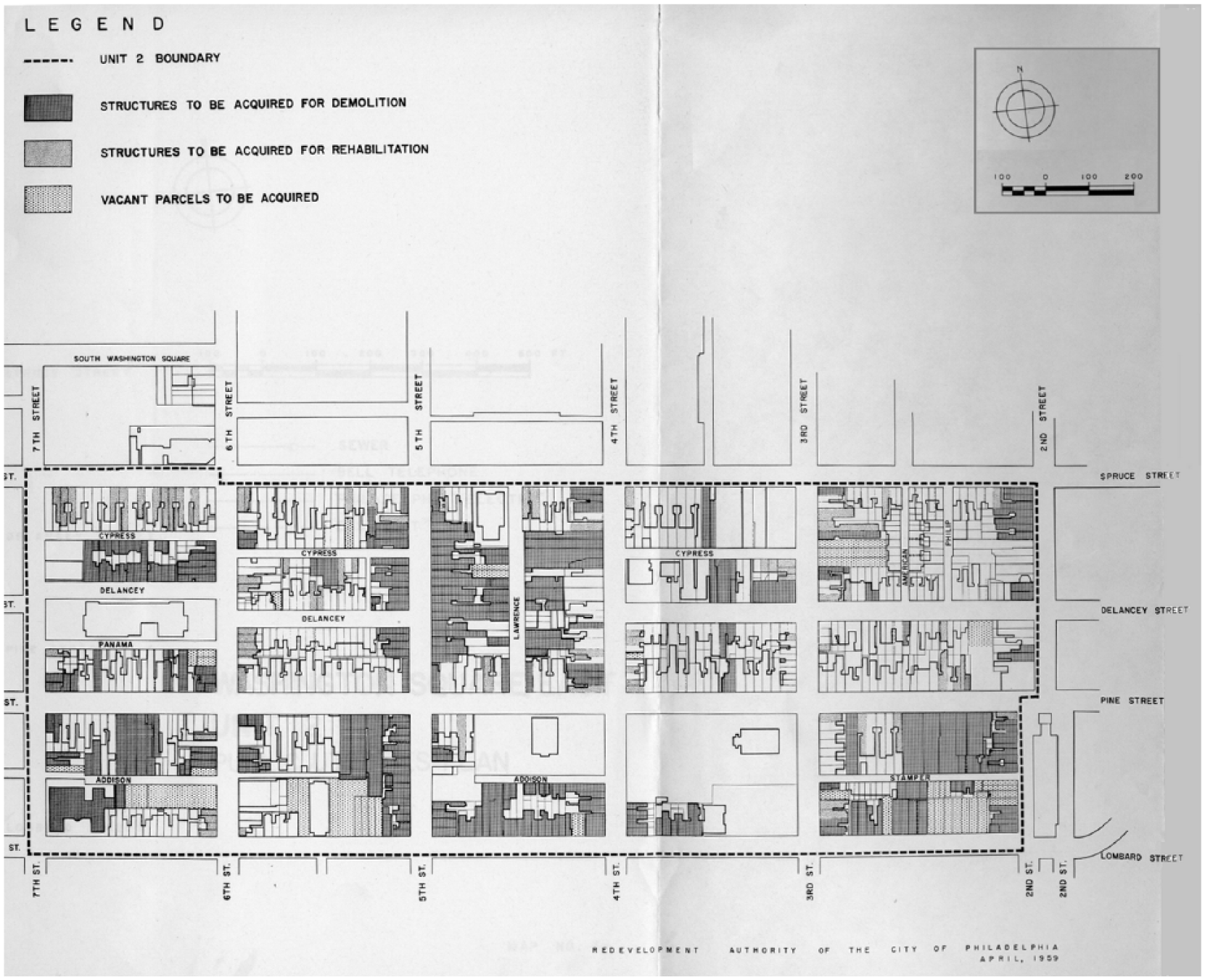
Acquisition, Clearance, and Rehabilitation Plan for Washington Square East, Unit 2.
Society Hill joined a growing number of preservation-based neighborhood revitalization projects. Most famously, this included College Hill in Providence, Rhode Island, Georgetown in Washington, DC, and Boston’s Beacon Hill (Garvin 2013, 285–300; Born 2017). But other cities also participated in a range of ways. For example, the Urban Renewal Authority profiled 12 contemporary examples—including Norfolk, VA; New Haven, CT, and Bethlehem, PA—in Historic Preservation through Urban Renewal (Carroll 1963). This pamphlet clearly aimed to encourage more such projects. Among this list, Philadelphia gained national prominence for the early timing and extensive scale of its initiatives, as well as the way in which rehabilitation became a cornerstone of renewal across the city’s many projects (Heller 2013). Even Time magazine took note, depicting Bacon on one of its covers, with a drawing of Society Hill behind him (Time 1964).
Scholars have shown how growing interest in retaining old buildings, increased federal funding to make such proposals practical, and recognition of the economic merits of rehabilitation over demolition all helped explain some of the why of preservation-based urban renewal (Page and Mason 2003; Ryberg 2013). Yet we know little about the ground-level how of getting this work done. Diverse photographic archives help illuminate that material process.
Typologies of Urban Renewal Images
The deployment of photographs for planning practice did not begin during the urban renewal era. Rather, photography and the city have been mutually constitutive since the birth of the medium in 1839 (Hales 2005). During the late 19th century through the New Deal, in particular, photographs depicted dilapidated or endangered buildings—in order to substantiate their demolition, or to capture their visual record for longer memory (Riis 1890; Burns 2004; Rauschenberg and Atget 2007; Spirn 2008; Foulkes 2011). Photographs of the urban renewal of postwar Society Hill are part of this genealogy. While recording proof of urban ills, they also reveal more complex photographic roles. As shown in Figure 3, the before-and-after photographic pairing, contrasting the disorder of previous conditions with the clean modernity produced by policy and design interventions, has been a common urban renewal visual trope. Expanding the chronology and typology beyond this simple binary more richly illustrates the multiple public and private uses of photographs in the planning field.
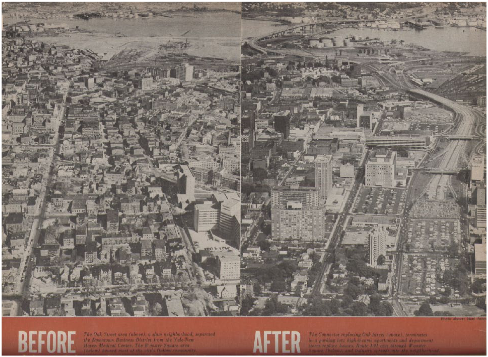
New Haven, Connecticut’s Oak Street neighborhood, before and after urban renewal.
In this article, I propose four photographic typologies that figured prominently in urban renewal practice. I then read the various photographic archives and images—including their content, construction, dissemination, and application—to demonstrate the ways in which distinct types of photographs have served particular purposes in planning practice. Such an approach reveals the complexity of photographs as culturally constructed evidence. This analysis uncovers images in multiple archives, including municipally produced photographs, the redeployment of historical photographs (such as those found in historical societies), personal snapshots likely to reside in scrapbooks, and professionally produced documentation created for preservation purposes. While the urban renewal of Society Hill serves as a useful case for demonstrating these typologies in action, this framework can also help parse the meaning and use of photographs in planning practice more broadly.
After describing the four typologies in brief, I then use this framework to structure the remainder of this article. First, “before images,” from immediate pre-renewal days, give visual form to the ambiguous category of “blight,” helping to authorize demolition or other planning interventions. Second, as an alternative to this dilapidation, “counter-images”—in this case depicting earlier historical scenes—help envision the renewal work that would follow. In Society Hill, such images shed light on how preservationists and planners defined what restoration should look like. Both types of images also demonstrate the importance of the sense of sight to authorizing output. A third group of “process images”—residing in varied archives—reveal the messy work of renewal in progress. Finally, carefully curated “after images” capture the sanitized outcomes of renewal for posterity, while also silencing the often destructive process behind these scenes’ creation.
“Before Images”
Architects Wright, Andrade, & Amenta developed technical plans for the renewal of Society Hill (Wright, Andrade, & Amenta Architects 1959). Their recommendations drew partly upon a visual survey conducted by an unknown photographer at this time (Figure 4). This survey resides on 46 heavy white cards, each measuring about 12 inches by 12 inches in size—plus 3-inch wide winged panels sometimes taped to their sides. Each card includes a map and select photographic views numerically tagged to their geographic sites. This survey was not complete. Rather, the photographer trained his or her eye on a subset of neighborhood vistas. Thick, red lines on the maps indicate streetscapes where photographs have been included, but there are gaps in that coverage. Further, the angled photographic perspectives obscure the legibility of many of the buildings in the surveyed stretches (unidentified photographers c.1950s). Overall, the images are more piecemeal and suggestive than comprehensive and detailed. 4

Photographic survey card for one partial block of Society Hill, before renewal.
The photographic sampling, combined with the cluttered composition of individual shots, seems to showcase the disordered aspects of the neighborhood. As shown in Figure 5, images document fire escapes, awnings, garage doors, and haphazardly parked cars. In backyards, they expose personal laundry hung out to dry. In a critique grounded in both aesthetics and a commitment to single-use residential areas, other photographs depict the visual cacophony of signage, commercial storefronts, and industrial structures amid dwelling units, as well as the incursions of gas stations and surface parking lots (unidentified photographers c.1950s). Rarely does the camera confront a building head-on to frame its full portrait, as do rectified architectural photographs like those produced by the Historic American Buildings Survey (HABS). 5 Rather, perspective views provide more sideways glimpses into the busy streetscape.

Selected views of Society Hill, prior to renewal.
These images were of a piece with race- and class-inflected photographs taken for purposes of urban reform over a half-century prior. When Jacob Riis photographed laundry hanging in the rear of Lower East Side buildings, he was criticizing not only the clutter, but also the ethnicity and class of those living that way (Riis 1890; Stange 1989). The clotheslines were neither good nor bad on their own; Riis constructed their meaning through his lens and the context he created. 6 Zoning photographs from the early 20th century framed the apparent disorder of “stores invading residence streets” and other mixtures of use (New York (NY) Commission on Building Districts and Restrictions 1916). As the history of zoning has shown, however, the unnamed objects of proposed material reforms have often been those racial or ethnic groups—including Chinese laundry owners, Jewish factory workers, and African-American residents—who were simultaneously displaced by restrictions on physical development (Freund 2007; Hirt 2014). Thus, visually oriented reforms of the built environment have sometimes helped mask associated social reforms.
The quest to eliminate multi-family and mixed-use properties in Society Hill continued this practice. Today, New Urbanists might view some of these “before images” as effective examples of lively mixed use and variety; but that was not the postwar fashion. As cities competed with growing suburbs, planners sought to reshape them in the suburbs’ image— including by standardizing design and segregating residential space. By removing businesses and multi-family rental units, renewal also displaced lower-income, often minority populations (Smith 1996). In Society Hill families, this included Eastern Europeans and African-Americans. Although some members of these groups would also occupy the renewed neighborhood, changes in property values often limited such opportunities to the middle and upper classes (US Bureau of the Census 1952, Tract 5-A, 1983, Tract 10).
People are noticeably absent from most of the Society Hill “before images.” They appear rarely, incidentally, and in small scale in the Wright, Andrade, & Amenta set (unidentified photographers c.1950s). In other municipal photographs produced at the outset of the area’s renewal, a photographer’s assistant sometimes shows up holding placards displaying building addresses (www.PhillyHistory.org). This minor presence suggests a concerted effort to focus explicit attention on the physical over the social, although the two were intimately entwined. It is not surprising, then, that anti-renewal activists often placed people at the center of their resistance campaigns.
While the meaning of blight was subjective, the Society Hill pre-renewal photographs bolstered the concept’s perceived authority through the survey’s sense of geographic comprehensiveness and technical precision. Card-makers numbered each photo and tagged its location on detailed maps, in a hand-drawn form of geocoding. The collection includes one map-based card for each neighborhood block, even when no photographs from that block were included. This implies an implicit faith in the authority of the photographer—and the planner—to sort the built environment, without having to share full visual data for broader inspection. The photographer is both data aggregator and curator. Whether or not these photographs were ever disseminated publicly, their backstage implications—as supporting evidence for clearance—are clear. In some cases, they even seem to have served as working documents, when selected parcels were crossed out or labeled by hand where demolition was to occur (unidentified photographers c.1950s).
“Counter-Images”
If immediately pre-renewal photographs provided proof for planners to remake the neighborhood, preservationists deployed a broader archive of “counter-images” to tailor these plans to individual buildings. As a general category, “counter-images” offer visual alternatives to the failings depicted in the “before images.” There are varied kinds of examples. Anti-renewal activists have deployed their own architectural photographs to celebrate existing development’s strengths and longevity, not its shortcomings. These images can reframe these buildings as worth saving, or focus on the community and social life that populate these same built scenes—suggesting the need to conserve them as well. 7 In support of new construction, as another example, architectural renderings can replace pre-renewal dilapidation with clean and modern designs. Yet in their sanitization, renderings also often replicate normative ideals. For historical restoration, photographic “counter-images” can highlight an earlier past to which contemporary advocates wish to return. In Society Hill, these historical images informed restoration decisions that sought to recover, or even fabricate, an earlier era. These decisions were grounded in subjective choices into which photographs figured strategically and selectively.
The restoration of 352 S. Fourth Street illustrates how historical images informed the restoration process—purportedly in indisputable ways, but not necessarily so in practice. In October 1966, the PRA agreed to convey the property to C. J. Moore for $10,500; the sale was complete four months later (PRA 1966, 1967). Typical of sales of the neighborhood’s historic properties, the agreement included detailed rehabilitation specifications. On the Fourth Street façade, consulting architect John Lloyd required the removal of bulk windows; restoration of the brick residential façade; repair or replacement of window frames and sashes (including the installation of small light sashes); installation of shutters on the first- and second-floor windows; cornice repair; masonry repointing; painting of all wood and metal in approved colors; and renewal or installation of an entrance door and frame of the period (PRA 1966).
Moore’s architect, Walton D. (Kip) Stowell, began corresponding with the PHC about the building’s restoration while the sale was in process. Having formed in 1956, the Commission reviewed preservation plans for individual sites (Tinkcom 1971). Given the group’s limited bandwidth, photographs—when available—offered quick and easily legible evidence into site histories. In 1967, Stowell sent the Commission a sketch of his proposed façade design. They responded largely approvingly, but also suggested some changes—including the retention of the Fourth Street doorway (whereas Stowell had only included Pine Street entrances). The basis for this recommendation was an 1860 photograph of the building (Figure 6). The image shows two blurry individuals passing by the Fourth Street façade. Most relevant to the Commission’s reply is the building’s front door: It is located on the Fourth Street side, while no additional doorway appears on the visible portion of the Pine Street side. The Chairman responded to Stowell, “Because the record is incontrovertible, [the Commission] strongly recommends that the doorway as shown in the 1860 photograph be restored … for the sake of historical accuracy” (Simon 1967). The Commission had discovered this image in May 1962, half a year before the PRA even acquired the property. At that time, someone had noted that the image was “a

352 S. Fourth Street, 1860.
Whether Moore was committed to earlier historical accuracy or just preferred the Pine Street doorway, he responded with a detailed alternative. Based upon interior observations of the building’s foundation and first floor, he concluded that the Fourth Street entrance was an addition dating to sometime between the house’s 1790 construction and the 1860 photograph. He even included his own present-day interior snapshots to prove it (Moore 1967). His argument passed muster and, just one month later, the Commission approved Stowell’s design (Nichols 1967). This case demonstrates the Historical Commission’s willingness to deviate from the historical photographic record. But, absent further evidence, the young, lean organization in charge of preservation turned to photographs for their innate truth value just as planners pursuing demolition were doing at that same time. In other words, photographs equaled proof until conflicting sources or advocacy proved otherwise.
Contemporary design preferences could also supersede photographic proof, further demonstrating the selective nature of photographs as planning knowledge. Many long-lived businesses fell victim to the prioritization of single-use housing over the mixed-use past. The 1860 photograph of 352 S. Fourth Street, for example, revealed that a commercial establishment had existed on that site at least a century prior to renewal. As C. J. Moore pointed out to the Commission, “the word ‘COAL’ can be made out on what appears to be a business sign to the left of the door in the photograph” (Moore 1967). But the Historical Commission was not raising this point while it was arguing, just inches away from that sign, for keeping the Fourth Street doorway intact. The “incontrovertible” evidence of these images was only valued when it aligned with preconceived planning goals.
By contrast, supporters of Harry Altman’s Royal Hand Laundry, located at 301 S. Fourth Street (Figure 7), used historical photographs to advocate for enduring commercial use on that site. During a public hearing in 1960, representatives of 7 of the 60 commercial establishments in Unit 2 pleaded to stay in the rehabilitated neighborhood. A representative of the Society Hill Area Residents Association (SHARA), composed of long-term residents, presented a photograph from 100 years prior showing a store in operation on that site. He further reported that, in 1927, Altman’s father had founded the laundry now located at that location; his son took it over in 1936. By 1960, then, the business was a more than quarter-century-old neighborhood institution. As the SHARA member noted, the laundry “was really a collection station; no work, either cleaning or laundry, [was] done on the premises.” Altman lived above it, further tying him to this site and community. With the onset of renewal, Altman had an architect design a new “Colonial front” for the building; and he contacted the PRA offering to modify aesthetics, but not operations. But he was apparently “told flatly, ‘Your property will be condemned’” (Philadelphia (Pa.) Committee on Municipal Development and Zoning (PCMDZ) 1960a, 62–63). One petition in support of the business, signed by 26 immediate neighbors, noted, “We are desirous of Mr. Altman continuing to render laundry and dry cleaning services as he has done in the past and we, therefore, pray that Mr. Altman be allowed to continue and use and rehabilitate his property” (PCMDZ 1960b, 150). The signatories even included Charles Peterson, a near-neighbor of the laundry, as well as the leading voice of historic preservation in Philadelphia at the time.

301 S. Fourth Street in the 1950s (left) and 1969 (right).
Similarly, hearing attendees presented historical photographs to support retention of a 50-year-old, family-owned barber shop business at 333 S. Fourth Street. As with the laundry (301 S. Fourth Street) and electronics shop (352 S. Fourth Street), the site’s longer commercial use extended back at least a century. Like Altman, owner Fred Ottaviano offered to modify his property’s exterior to comply with aesthetic guidelines. Or he offered to relocate to his other property at 331 S. Fourth Street, which was already “Colonial in appearance, and was formerly a beauty shop.” Again, the speakers presented visual evidence to support their case. As the SHARA representative noted, “I have here a photograph of the old houses in 1858, showing the particular location where this barber shop is … and you will notice that practically every house in the block on that side was a store with an overhanging, old, iron awning that they used to have.” He concluded, “The retention of this particular barber shop, and it is the only store in that location, certainly cannot affect the original character of the street or the present residential status of the street.” The Evening Star also came out in favor of all seven exceptions, noting that “Philadelphia is not all homes and never was” (PCMDZ 1960a, 62, 67).
But, 50–100 years of commercial use was not historical enough, and the planners carried the day on all of these sites. The Association of Home Owners of Washington Square East, a second civic group composed of more recent property owners, had formed explicitly to support the PRA’s goals. They endorsed the eradication of all existing commercial use in residential areas, arguing that “Supposedly small adjustments and concessions here and there can eat the heart out of this admirable plan” (PCMDZ 1960b, 99). While SHARA also supported the overall residential plan, it felt that these few, scattered businesses would not adversely affect the end product. Further, “it believe[d] that families who have owned their properties and have conducted for many years an essential neighborhood service business therein, should receive favorable consideration.” Original historical architectural values were not their sole or primary objective; rather, they turned to a more temporally expansive version of history—and its corollary photographic evidence—to bolster the case for “human values” as well (PCMDZ 1960a, 67, 75). Instead of community-oriented residents with a multi-layered sense of history driving the shape of the rehabilitated neighborhood, however, planners marshaled restoration in a more singular way: They deployed the practice as an excuse for transformational planning with contemporary tastes in mind. When photographs abetted their timeline and cause, they turned to them willingly; otherwise, they let ideology override visual evidence. Thus, the power of the photograph could be significant, but also contested.
“Process Images”
“Process images,” which depict the work of renewal in progress, expose the realities of implementation and what planning ideas meant on the ground. In Society Hill, “process images” reveal postwar preservation as not only restorative, but also destructive. The plan to turn back the architectural clock to the late 18th and early 19th centuries transformed façades throughout the neighborhood, while also erasing much history. First-floor facelifts, as occurred at 352 S. Fourth Street, were common along formerly mixed-use thoroughfares. More dramatically, many rear sheds and other outbuildings came down entirely. The rehabilitation specifications for 352 S. Fourth Street, for example, required the demolition of a one-story brick garage and two-story rear addition (PRA 1966). Elsewhere throughout the neighborhood, preservationists like Charles Peterson argued for the survival of some outbuildings when they were integral to past operation of the larger property, but his efforts often proved unsuccessful (Sunday Bulletin 1962). Interiors, which were largely outside Historical Commission purview, experienced equally substantial changes. Older layouts easily yielded to modern, even suburban-style, living as planners attempted to lure residents back to the city. Since much of this physical work occurred behind closed doors, surviving construction photographs offer invaluable windows into the physical nature of this process.
C. J. Moore was aware of the messy and destructive work of restoration since he documented it with snapshots that he filed in a personal scrapbook (Figure 8). These images complicate the clean transition from before to after that is portrayed by most official photographs. Architect Kip Stowell inserted two contemporary, semicircular openings into the rear façade of 352 S. Fourth Street: One held a window, and the other opened to a balcony. Here was a case of mandated demolition of an addition, followed by modern construction in the “reconstructed wall” of a historically certified house undergoing “restoration.” Another image shows Moore examining the in-progress gutting of interior framing. But these were his personal snapshots (Moore n.d.). The public story—typically told through images of the finished product—erases the messiest realities of mid-century preservation. Expanding the visual archive beyond official planning documents to also include personal photographs illuminates the fuller contours of this work.
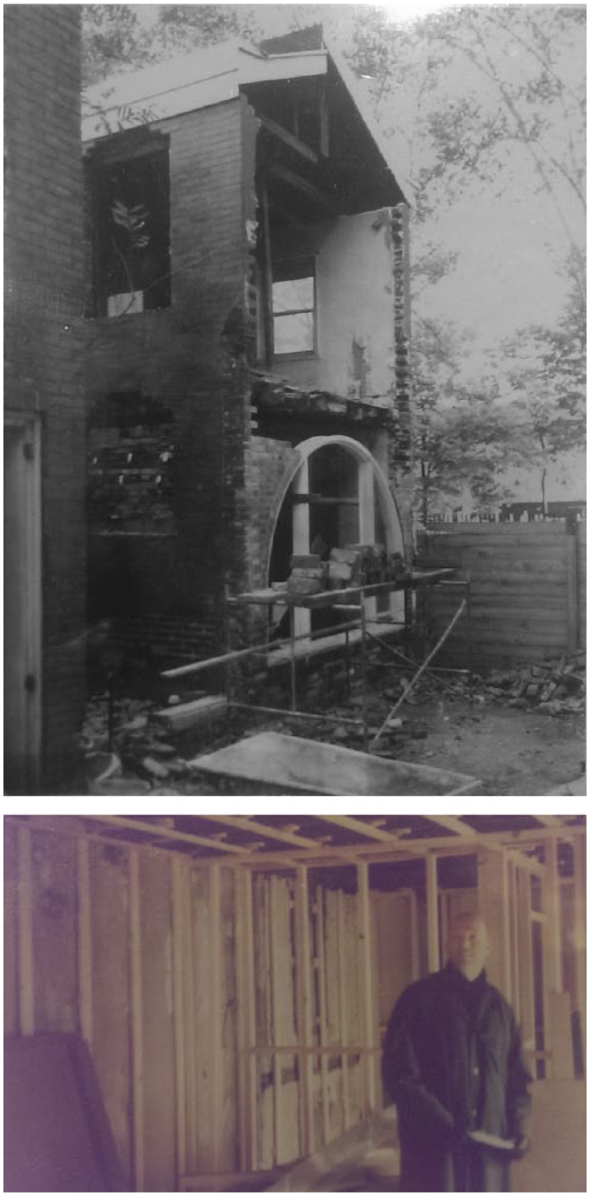
Rear façade and interior of 352 S. Fourth Street under renovation, c.1967.
Preservationists also supported maintaining interiors, but often lacked the power to require it. Even when the Historical Commission had the chance to weigh in, not all of its members valued material conservation equally highly. For example, the Commission’s Architectural Committee approved dramatic interior changes in one historically certified house on S. American Street. As one frustrated historian member of the committee noted, the decision “represent[ed] the opinion of the architects on the committee, who think modern living within the house should supersede historical values of existing interior fabric” (Maurer 1970a). As external validation for the architects’ sentiment, the 1971 Chicago Furniture Show awarded a prize to the owner of another house, 320 S. Fourth Street, about which one journalist wrote, “Crossing the Fourth St. threshold is like stepping forward two centuries.” Although “everything that remained of traditional value when Mrs. Grace bought the place five years ago has been tenderly preserved … the house inside is strictly 1970” (Barnes 1971). But this perception of value was subjective. In Philadelphia, during the same year as the Furniture Show, the Chairman of the Historical Commission lamented to the OPDC about this same house. Referring to 320 S. Fourth Street and the aforementioned S. American Street property, he wrote: “both have been entirely altered within, even though both had all their original features intact when purchased.” The author powerlessly hoped the OPDC would remind future purchasers of the historical value of interiors, as well as their obligation to delay construction until they had obtained a building permit and approval of the Historical Commission (Tyson 1971).
Despite the extent of such destruction, planners’ approach to urban renewal in Society Hill preserved much more physical fabric than in communities focused on clearance alone; but conservation did not necessarily extend to the neighborhood’s social fabric. By 1966, renewal was projected to displace 580 families from Society Hill; ultimately, those numbers rose to roughly 6000 individual residents (US Renewal Assistance Administration 1967; Smith 1996, 137). The process removed renters, as owners converted multi-family buildings to single-family use. It even priced out owners themselves when the costs of the requisite restorations—as prescribed by the Redevelopment Agency as a precondition for purchasing back their Agency-acquired property—were more than they could afford.
Changing neighborhood demographics reflect this transformation. Recall that, in 1950, before renewal commenced, Society Hill included roughly 7000 residents. Among these, median family income was half the city average, and fewer than 4% of adults had completed college. By 1980, when renewal was largely complete, there were 5200 residents, median family income was 2.5 times the city average, and 64% of adults had completed college. Despite the decline in population, thanks in large part to the construction of Society Hill Towers, housing units had increased—from 1965 to 3183. Owner occupancy had more than doubled (from 18% to 40%), and these owner-occupied units now cost seven times the city average (versus three-quarters of the city average in 1950) (US Bureau of the Census 1953, Tract 5-A, 1983, Tract 10). Thus, one population displaced another, even as many buildings remained (Beauregard 1990; Smith 1996).
Atypically, the racial mix had not changed as substantially. By 1980, nearly one-quarter of Society Hill’s population was non-white, compared with nearly 19% at the start of renewal. Federal reports show that roughly 20% of those displaced from Society Hill were non-white (US Renewal Assistance Administration 1967). This is an inversion of both city-wide and national statistics, whereby non-white residents on average bore roughly 70% of the displacement burden. For this reason, urban renewal earned the nickname “Negro removal.” In Society Hill, however, African-Americans made up both pre- and post-renewal populations. Displacement was relatively invisible in municipally produced images, but journalistic photographers depicted the human dimension of the urban renewal story, albeit anecdotally. The Philadelphia Inquirer and other local newspapers, for example, profiled the noteworthy case of seven low-income African-American households who successfully used the courts to resist displacement by the PRA (Randall 1973). Unlike the city’s pre-renewal photographers, these journalists made residents more central to the story.
“After Images”
The social and material labor of renewal were often difficult to discern in the pristine “after images” used to document the project’s completion. The sanitized still frames, like those produced in Bernie Cleff’s 1987 exterior survey, capture a finished product that erased this past from view—although the astute observer can still locate material traces of transformation, such as in replacement brick surrounding restored doorways and windows (see Figure 1). Such “after images” were necessary accompaniments to the written documentation submitted for historic district designation.
Individual homeowners required similar photographic evidence to obtain Historical Commission recognition of their properties. At the completion of restoration, a homeowner could send in an application including a letter of request and a 5 × 7 photograph of the façade. This image was critical to the review process. As a Commission member informed one applicant, “The architects review a photograph with as much care as is given the drawings on which restoration is based. The finished work must show all facades and be clear enough so that the quality of the work can be clearly seen” (Maurer 1970b). With Commission approval and $25, the homeowner could then receive an exterior historical certification plaque from the manufacturer (Nichols 1969a).
The Commission’s definition of historic restoration was broad—sometimes even including reconstruction. For example, Kip Stowell’s restoration of 341 S. Fourth Street turned a three-story Victorian structure into a 2½-story neo-colonial one (Figure 9). The PRA required that the new owner “remove entire front, reconstructing a brick façade in keeping with style of the area,” including pairs of six-over-six sash windows on each floor, a raised panel door, and a pitched roof. Shutters were optional “dependent upon period picked for reconstruction” (John Lloyd Architect, n.d.). In the absence of historical photographs, Commission members also sought evidence of original fabric. But the new owner confessed, “There are no visible signs of any old arches [in the basement] that may have been original structures.” Further, he could not “in all honesty say that the building is a completely new structure” (Ottaviano 1969). Put differently, he could not say that it was not all new either. A corroborating historical insurance survey, “plus the very good photographs you have been kind enough to send the Commission” led them to approve the certification and issue the plaque (Nichols 1969b). Thus, an after image could help prove successful “restoration,” even without any historical image complements.

339 and 341 S. Fourth Street, before (c.1957) and after (1970) restoration.
Homeowners also helped produce after images of interiors. C. J. Moore commissioned Lawrence S. Williams to take interior photographs of 352 S. Fourth Street after restoration was complete. Williams captured the updated central staircase and the architect himself seated on the wall-to-wall carpeted living room floor (Moore n.d.) (see Figure 10). A photograph of the kitchen even appeared in the lighting chapter of the book Designing Interior Environment (Alexander 1972, 109). Historical Commission members also visited selected houses, with the homeowners’ permission, to document interiors (Maurer 1970a, 1970b).

Interior views of 352 S. Fourth Street, c.1970.
The pairing of before and after images told simplified stories of how architects and planners restored order from dilapidated chaos. This helps explain Kip Stowell’s request to the Historical Commission, in 1971, for a copy of the 1957 “before image” from 352 S. Fourth Street. He hoped to pair it with his own after images “for job hunting and publishing purposes” (Stowell 1971). The Commission responded with enthusiasm: “Anyone seeing this ‘before’ view, taken in 1957, when the Commission was just beginning its work in the area known as Society Hill, would never guess the photographs taken when your restoration of it was complete is the same house. All concerned believe this is one of the best examples of good restoration technique” (Maurer 1971). In much of Society Hill, then, preservation meant transformation. The before and after photographs provided the visual proof of these dramatic changes, while omitting the complexity and contestation behind them.
Conclusion
Drawing in large part upon photographs, this article demonstrates how residents, architects, planners, and preservationists combined demolition with restoration to realize urban renewal practice on the ground. This approach takes us beyond plans alone—to individual buildings and sites—in order to consider the constructed reality of renewal. 8 Preservation might seem like the opposite of the “culture of clearance” that characterized postwar development in many US cities. This is particularly so if one focuses primarily on the end products. But, examining the preservation process, inside and out, reveals a different—but related—focus on remaking that destroyed even while it retained. This is not to devalue the built fabric that was saved, but rather to situate postwar preservation as a sometime participant in the destructive nature of the era. Some preservationists, like Charles Peterson, ardently advocated to save as much fabric as possible, while also allowing exceptions to preserve social values. But the competing ideologies of planners and new residents to realize a modern lifestyle, separating residential and commercial use, often won out against more expansive preservationist concerns. As a result, even historically certified buildings fell, interiors transformed, residents relocated, and long-standing mixed-use development gave way to a largely single-use residential environment.
Through their evidence of renewal before, after, and in progress, photographs prove invaluable to reconstructing this nuanced story. “Before images” selectively sampled pre-renewal scenes, helping to designate a neighborhood as blighted. They also legitimated the interventions that followed. “Counter-images” picture alternatives, making the case for specific planning interventions, including demolition and new construction, or rehabilitation and preservation instead. Where available, “process images” show how renewal functioned in progress. Here, photographs play a largely documentary role, abetting the historical record of planning practice. The final type, “after images,” document the completed neighborhood, while simultaneously obscuring the often destructive process behind these scenes’ creation.
Plumbing a variety of personal and bureaucratic archives to unearth photographs of rehabilitation in progress exposes a fuller picture of the tensions—destructive versus restorative, modernizing versus historicizing, social versus aesthetic—that underpinned postwar preservation planning. Photographs help illuminate the very meanings of history and preservation at a foundational moment in the development of the field. Moreover, these images suggest the often-silent ways that photographs have shaped planning practice, including the ways in which they can selectively reveal or conceal.
While the history of the Society Hill case richly illuminates photography’s sometimes subtle, but persuasive, role, the power of the photograph extends well beyond postwar urban renewal alone. It also applies to other planning eras and practices, from zoning disputes of a century ago, to environmental battles over 1960s highway and suburban growth, and post-disaster planning following events like Hurricane Katrina (Blake 1964; Taylor 2014). 9 Both planners and everyday citizens should continue to be attuned to this power today. Admittedly, digital technologies have increased the volume of images, as well as planners’ capacity for organizing and mapping them. Aerial images can also make possible new means for measuring land use. But photographs’ more basic functions on a qualitative level have not substantially changed. The four-part photographic typology identified here offers one possible tool for deciphering those.
Four years ago, in just one recent example of photographic applications in planning, smartphone-carrying photographers canvassed every parcel in Detroit to create a visual census of blight (Davey 2014). Their images helped produce detailed maps of building conditions for the Detroit Blight Removal Task Force (Byrnes 2014), which ultimately aimed to target demolition. These images call to mind the apparent precision and comprehensiveness of the Society Hill survey, again coupled with the subjectivity of the image makers and the underlying objective of excising incongruous conditions. As in the past, visual documentation was a crucial step in substantiating planning intervention.
But photographs cannot stand objectively, self-evidently, or on their own; and they never have. Other images—of past, present, and future—also shape our understanding of these spaces. Further, the meanings of any of these photographs have always been culturally constructed; and different perceptions of value can drive different ways of seeing the same scene. When viewed from the perspectives of a more diverse group of stakeholders, these landscapes and their photographic depictions may also lead the city down other paths of action besides demolition alone.
To return to the four-part typology, the Blight Removal Task Force photographs are examples of “before images.” What “counter-images” exist to put these photographs into context and suggest paths forward? Today, digital 3D models and 2D renderings often offer such alternative visions, but past photographs of these same spaces—highlighting history and community—can inform other trajectories. Putting “before images” like those of the task force survey into a thicker visual and conceptual context interrupts what may initially seem like a direct pathway from scenes of dilapidation “before” to pre-ordained demolition “after.” A vast archive of historical images—documenting past planning practices and their impacts—offers valuable fodder for envisioning the process connecting these two states. In particular, they help lay bare the false simplicity suggested by before-and-after photographic dichotomies alone.
The allure of smart cities and big data suggests increasing quantification of the field today; yet, we should also remain attuned to the enduring contributions of photographs—and of qualitative data more generally—to planning knowledge. Understanding photographs as planning knowledge requires a humanistic sensibility and a capacity for reading this culturally constructed data—both as large archival sets, and as individual images—for the stories they tell as well. This is not to suggest the unbiased nature of quantitative data either, for it too can be culturally constructed. Rather, it is a call not to lose sight of qualitative sources and the interpretive readings that they require. Thoughtful analysis compels us to consider both.
Looking beyond urban renewal alone, scholars should continue to explore the unarticulated logics that images reveal about past planning practices. Similarly, we should be attentive to the logics and embedded powers that planners ascribe to photographs—and to all kinds of visual representations, from low-tech hand sketches to heavily processed digital reconstructions—today. Urban renewal was just one of many moments that called photography’s incontrovertible truth value into question. Since then, theorists like Martha Rosler have troubled the power imbalances of the photograph and posited an era of the post-documentary. But, the documentary image persists (Rosler 2004a, 2004b). As planners continue to deploy photographic evidence both subtly and explicitly, they should do so with an awareness of this long and complex history. The historical interplay between planner and photograph demonstrates the role of these images as more than just illustrations. They have also been, and will continue to be, culturally constructed and instrumental evidence with the power to transform buildings, landscapes, and lives.
Footnotes
Acknowledgements
The author wishes to acknowledge helpful feedback received from audiences at conferences of the International Planning History Society, Urban History Association, and Association of Collegiate Schools of Planning, as well as at the University of Pennsylvania’s “Picturing Policy” symposium. She also especially acknowledges constructive suggestions from Aaron Wunsch, members of the Humanities + Urbanism + Design initiative at Penn, colleagues in the “Architecture and/for Photography” research initiative at the Canadian Centre for Architecture, and the anonymous readers and editors at JPER.
Declaration of Conflicting Interests
The author declared no potential conflicts of interest with respect to the research, authorship, and/or publication of this article.
Funding
The author received no financial support for the research, authorship, and/or publication of this article.
