



Abstract
Planners and researchers need instruments for assessing the construction of future images. We propose an argumentative model for assessing instrumental and constitutional images in plans, supported by three master criteria—consistency, coherence, and plausibility—that encompass alternative argumentation strategies and image-building processes. We applied it to an assessment of planning documents in the metropolitan area of Granada, identifying main argumentation backgrounds (metropolitan/urban reforms, transport corridor design, and integration) and fields (demand- and capacity-based) in the formation of the image of Light Rail Transit as an integrated metropolitan system and as urban access system.
Introduction
The assessment of the future effects of plans involves two levels: “first order effects,” linked to direct outcomes of planning projects and policies, and “second order effects,” focused on actors’ relationships and “strategic momentum” of spatial plans (Mäntysalo and Grišakov 2017). Light Rail Transit (LRT) projects have become part of strategic interventions in urban development and spatial plans, pursuing second-order effects hard to assess (Ferbrache and Knowles 2017; Olesen and Lassen 2016). But in some spatial planning traditions, such as in Spanish metropolitan plans, conformance-based assessment dominates practice, enforcing accurate representations of future physical systems rather than the visualization of strategic concepts (Elinbaum and Galland 2016). However, these plans still play their role in the consolidation of institutional images and narratives in the long term (Neuman 2012).
Planners and researchers need new instruments to understand the role of future images (i.e., visions, concepts, and ideas) in the elaboration of plans beyond the sphere of strategic planning. Urban and transport planning researchers have tried for decades to incorporate scenario planning techniques dealing with future image or vision building processes (Soria-Lara and Banister 2017). But when it comes to evaluate such images, scenario planning hardly goes further than grasping few desired images from organizations or wider participating communities, without deeper discussions about shared or conflicting visions (Zapata and Kaza 2015). This leads to the main research question of this paper: how planners and researchers can assess images about the future in more insightful ways?
This paper aims to develop an argumentative approach for planning assessment, able to deal with argument building and validation processes across multiple planning approaches (i.e., rational, communicative, and pragmatic). We conceptualize an argumentative model and apply it to an assessment of complex images and institutional visions of the future LRT system in planning documents of the metropolitan area of Granada. The assessment highlights main hypotheses about Granada’s LRT and captures alternative argumentation strategies in three master criteria—consistency, coherence, and plausibility—in connection to backgrounds and fields of argumentation specific to the case.
In “The Assessment of Transport Images in Planning: Toward an Argumentative Approach” section, we highlight the importance of assessing the image of LRT systems and the limitations under traditional planning approaches. Then, we conceptualize a potential argumentative turn in planning assessment under mixed approaches (i.e., rational and communicative). In “An Argumentative Framework for Planning Assessment” section, we describe our argumentative framework and how it is used in the assessment of planning documents. In “Argumentative Elements, Fields, and Backgrounds in the Assessment of Granada’s LRT Images” section, we elaborate on key fields and backgrounds of argumentation for the Granada’s LRT implementation. In “Discussion: Implication of an Argumentative Approach for the Assessment of Images in Transport Planning” section, we synthesize results and discuss the wider implications of our model for integrating different approaches in the assessment of planning images. “Conclusion” section offers some remarks for further research.
The Assessment of Transport Images in Planning: Toward an Argumentative Approach
LRT Projects as Image Builders
The design of LRT systems obeys to transport needs and expectations in quite distinct planning contexts: urban renewal and development operations, reforms of the transport system, replacement of old rail corridors, and so on (Hass-Klau and Crampton 2002). Consequently, there is no single model to assess and compare the whole set of benefits and drawbacks of LRT projects. In addition, early critics exposed myths about system capacity and efficiency (Rubin, Moore, and Lee 1999). Urban impacts are frequently constrained to “catalyzing” or “boost” effect (Ferbrache and Knowles 2017). Broad support of LRT projects in the past decades goes beyond criteria in traditional assessment tools, such as cost-benefit analysis; it entails more intricate processes guided by urban actors as they define and consolidate mobility problems, such as traffic or sustainability (Nicolaisen and Olesen 2017). Harnessing more subtle urban transformations from transit projects requires a previous understanding of image-led planning processes (Higgins and Kanaroglou 2016).
In Spain and the Andalusia region, perception of the role of LRT projects depends on the implementation context: the recovery of urban rail corridors following the reforms of regional systems since middle 1980s; the coordination of efficient multimodal solutions in urban areas during the 1990s through “intermodal transport plans” (Consejería de Obras Públicas y Transportes [COPT]/DGT 1998); and introducing urban innovations for gathering political, social, and financial support for new transit projects (Valenzuela-Montes, Soria-Lara, and Talavera-García 2011). In Granada, the urban agglomeration plan (Plan de Ordenación Del Territorio de La Aglomeración Urbana de Granada [POTAUG] 1999) promoted the recovery of a transport network resembling the old regional electric tramway system; at the same time, the central city needed for an alternative access system to bypass and mitigate the congestion of radial roads and the main north–south corridors (Estudio de transportes en la Aglomeración Urbana de Granada 1998). Later negotiations between municipal government of Granada and the Transport Council of the Andalusian region focused almost exclusively on the West Corridor, starting new ad hoc debates about urban connections to neighborhoods and regional transit projects, and the feasibility of an underground solution. As a result, traditional assessment tools for the project survey (Gestión de Infraestructuras de Andalucía, S.A./AYESA 2002, 2003) failed due to the lack of a previous political consensus about project goals, some of them ill-defined (such as “urban integration”).
Debates around new LRT projects revisit organizational concepts for urban planning. The hybrid role of intermedium capacity systems offers a whole range from robust (permanent, referential) to flexible solutions in the rearrangement of transport systems (Vuchic 2005). The management styles of infrastructure projects have shifted from rigid top-down planning to more adaptive stances, open to deliberation with different actors (Koppenjan et al. 2011). Conceptual goals of LRT projects have also changed from ensuring transport flow to gaining access through multiple mobility services in urban and suburban areas (Olesen 2014). Integration of transport projects goes beyond mere infrastructure “greening” and entails finding common grounds for discussing issues from the local scale (e.g., use of the street section) to the regional scale (e.g., metropolitan access to the system; Olesen and Lassen 2016).
We aim to address the impact of such abstract concepts of LRT in the planning process by analyzing the formation of images. We previously need to address the role of images in planning assessment and to develop argumentative tools that help us to identify them in planning documents, as we face contexts lacking open participative and strategic processes.
The Assessment of Planning Images
Integrating evaluation into planning practice is one of the main challenges in planning research (Oliveira and Pinho 2010). How planning images are used depends on the approach to planning assessment: rational, communicative, and pragmatic (Guyadeen and Seasons 2016). Rational approaches assume that plans are projects able to transform physical systems under a set of goals and direct actions; assessment is conformance-based, as it takes into account the distance between real urban objects and their representation in the planning image. The communicative approach considers plans as part of strategic processes, requiring frameworks for deliberation and consensus building (Faludi 2000); assessment is performance-based and it stresses how often actors make references to plans. A pragmatic approach integrates conformance and performance perspectives for adapting to the diversity of planning settings, from operational—for example, closed to single organization or vertical hierarchy—to strategic—for example, open, horizontal, multi-actor (Valenzuela-Montes and Soria-Lara 2012).
Although image-building aligns with the idea of performance, participation and strategy are often confined in the Spanish context to early political discussions of planning basis and normative public consultation. Integrated approaches consider both instrumental and constitutional images of plans. In a conformance-based assessment, images are instrumental to plans, becoming planning products that accurately depict desired goals, viable options, and expected effects after implementation (Laurian et al. 2004; that is, the “first order” effects of plans). In performance-based approaches, images become frames for planners, designers, and decision-makers as they confront multiple issues and discussions (Faludi 1996; that is, the “second order” effects). The idea of framing is innate to the transport policy field addressing complex planning problems (Olesen 2014; Pettersson 2013): “Framing is a way of selecting, organizing, and making sense of a complex reality to provide guideposts for knowing, analyzing, persuading, and acting” (Rein and Schön 1993, 146). Faludi (1996) describes framing as the process of shaping knowledge, either literally, with external images, or metaphorically, with internal images (concepts or visions). External planning images become the source of visual languages (e.g., areal, connective, or nodal spatial elements; Dühr 2007). Images can be internalized as part of planning doctrines, providing synthetic concepts, procedures, and principles used by organizations (Faludi 1996). Neuman (2012) identifies constitutional images as those generated and internalized during the life cycle of metropolitan planning institutions.
The integrated assessment perspective presumes that plans are built across multiple frames, either embedded in one organization or shared by multiple actors. This approximation seems more realistic to the multifarious models under which LRT projects come to plans. Two additional difficulties emerge in context lacking formal deliberative processes: not all references to planning codes are explicit, nor their context is considered, and the analysis of planning documents departs from a necessary interpretation.
We argue that elaborating arguments, in a real, experimental, or virtual debate, is the most evident result of plans either conforming to instrumental images or performing under potentially constitutive images. But argumentative analysis needs itself to be expanded under different assessment approaches.
Arguments for Enhancing Planning Assessment
Interest in argumentative theory for politics and planning emerged in the 1970s, with the search for a nonformal theory of reasoning and argumentation. Lapintie (1998) refers to three main approaches: (1) rhetorical, influenced by Perelman’s new rhetoric, in which arguments have a persuasive function toward an “universal audience”; (2) dialectical, influenced by Toulmin’s critics on formal logic (i.e., classic syllogism and deduction), in which informal argument analysis favors practical reasoning and justification, avoiding political manipulation; and (3) pragmatical, following van Emmeren and Grooteendorst’s pragma-dialectical rules for critical discussion and the study of fallacies in resolving difference of opinion.
Reviewing arguments independently from planning conclusions is a way to understand assessment under different decision-making rationalities (Martens and van Weelden 2014). A dialectical approach is compatible with a pragmatic expansion of the rational model, in which analysis of arguments serves as a tool to find proper areas of decision-making, integrating a greater deal of information sources (i.e., policy evidence, norms, and values; Goldstein 1984; Lapintie 1998). New rhetorical and pragma-dialectical approaches are closer to the communicative turn in planning, as a new set of principles and procedures adopted by planners to promote understanding and consensus in open debates (Healey 1993). The so-called “argumentative planning” model belongs to the second approach, as it pays attention to shared frames and languages from different planning backgrounds—lay, expert, technical, and natural; it takes the everyday language as the base of policy, planning, and spatial design (Faludi 1996).
Each of the previous approaches brings different tools for planning assessment.
Argumentative models based on the revision of informal logic are useful in rational argumentative analysis. The popular Toulmin–Dunn (1993) model connects claims with empirical evidence (grounds), inferential rules (warrants and backings), and boundary conditions for argument (qualifiers and rebuttals). The Rittel model (Thorbjoern 2010) introduces argument assessment into planning, assuming a less structured discussion process in which certain claims or issues iteratively emerge. The model typifies claims as deontic (D-claims), factual (F-claims), and factual-instrumental (FI-claims), relating each other under different inferential rules. It also proposes a set of criteria: truth, probability, plausibility, scale, and significance. The inference-warrant elements of the previous models elicit different forms of scientific reasoning existing in planning (Goldstein 1984): utilitarian, from classical economy; system-based, from natural sciences and engineering; and procedural, rooted in institutional practices, ethics, and law. Furthermore, spatial planning and policy design often use exploratory arguments, based on provisional hypotheses. Khisty and Arsland (2005) adapt the Toulmin–Dunn model to an abductive (i.e., exploratory) inferential logic for transport planning assessment.
Informal logic models hardly depart from linear “if-then” and “end-means” propositions (Gasper and George 1998) and are difficult to apply to the messiness of values, goals, and actions in real assessment contexts. New rhetoric approaches use instruments from discourse analysis to embrace the social functions of arguments. Arguments are not only persuasive, in a sense of manipulation or distortion, but constitutive: they add rhetorical tropes (i.e., metaphors and figures of speech) and narratives that shape the vision of the technical and policy communities as they make sense of complex problems (Throgmorton 1993). Argumentation becomes a “frame-reflective exercise” (Rein and Schön 1993) that contemplates how arguments reframe planning contents (claims, representations, codes . . .) and processes (new agents, events, contexts . . .).
Consideration of different argumentation fields (rationalities, structures, dialectics . . .) and backgrounds (actor relationships, decisions . . .) in diverse planning contexts was key in the development of our argumentative model for planning assessment.
An Argumentative Framework for Planning Assessment
The Argumentative Model
We propose an argumentative model for assessing instrumental and constitutional images in plans. It involves five argumentative elements: hypotheses, environments, products, representations, and mechanisms. Its design takes a flexible interpretation of informal logic models (see previous section), highlighting relationships between the background of argumentation and the field of argumentation (see Figure 1).
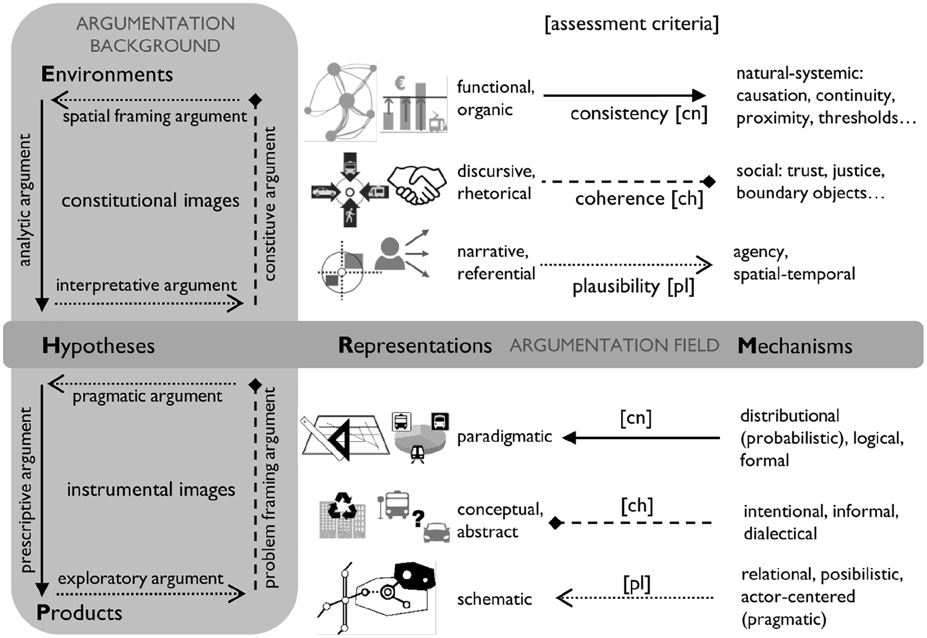
Argumentative model interpreting planning images from different assessment criteria.
The model departs from the premise that any kind of assessment is guided by planning hypotheses (H), that is, claims, issues, or statements that shape planning knowledge to fit certain contexts, audiences, and purposes—as evidence, learnings, practical implications . . .
The background of the argumentation involves those elements related to the contextual functions of argumentation. First, the planning environment (E) consists of the set of relationships between key actors, represented by objects or subjects (their intentions and decisions) that help to interpret planning hypotheses. Second, planning products (P) are the sources of information about options, effects, and criteria (documents, analysis, discourses . . .). Both elements are central in understanding the contribution of arguments to constitutional images (environment-based) and instrumental images (product-based).
The field of argumentation refers to the combination of strategies and rationalities that strengthen (or weaken) planning hypotheses. It brings two reinforcement elements inherent to every hypothesis: planning representations (R), as potential encoding devices that give symbolic or visual form to the hypothesis, and mechanisms (M), as background logics, processes, and heuristics enabling representations (instrumental images) or promoted by them (constitutional images). Representations and mechanisms are analogous to the warrant-backing elements of Toulmin–Dunn (inferential fields) and are adapted to the formats usually deployed by planners.
The exploration of relationships between elements in backgrounds and fields of argumentation orients the choice of assessment criteria, as follows.
Assessment Criteria and Argumentative Strategies
There are multiple ways in which arguments strengthen, weaken, or adapt planning hypotheses to given backgrounds and fields. We propose three master criteria for assessing planning hypotheses: consistency, coherence, and plausibility. These criteria are based on previous works about assessment of future hypotheses in scenario planning (Navarro-Ligero and Valenzuela-Montes 2019). Each criterion entails alternative argumentative strategies involved in image-building processes (Figure 1):
Consistency refers to arguments that validate the occurrence of planning problems (analytic) and the inferred effectiveness of the proposed solutions (prescriptive). Such arguments fit to objective technical-scientific environments, used to convince “neutral” audiences. They transform constitutional images, highlighting functional, morphological, and organic aspects, into paradigmatic instrumental images that describe reality as it is. “Naturalization” of planning solutions (Lapintie 1998) works here as a basic argumentative strategy. Analytic and prescriptive arguments are supported by analogic representations of physical systems (close, or with hard boundaries; that is, categorical), based on efficient causality (deterministic behavior), continuity, and distributional logics (classic probability, gravity . . .).
Coherence refers to the capacity of certain arguments for changing perspectives on planning options and effects (problem-framing) and increasing the significance of planning problems (constitutive). Arguments shape reality in a way it is meaningful for certain audiences and makes them position about problems. They transform instrumental visions that depict reality “as it could be” into constitutional discursive/rhetorical images, built on new languages (verbal and visual) and rhetorical tropes. In opposition to naturalization strategies, mechanisms used are explicitly intentional: they create social interactions and networks, based on trust, responsibilities, identities, shared boundary objects, dialectics, and decision frames.
Plausibility involves a variety of arguments that help in designing planning solutions: arguments that externalize the visions of planners into visual representations of options (spatial-framing/pragmatic) or internalize representations into new visions (interpretative/exploratory). Arguments reinforce instrumental images by exploring potential connections between the objects designed by planners and the actors of an imagined world (“design worlds,” in Faludi 1996); they transform more complex visions into simpler and more intuitive ideas, enabling action. Arguments support constitutional images by creating self-referential frameworks and narratives focused on the decisions of certain actors. Mechanisms imply structurally open logics (relational and process-based, inclusive, selective . . .), according to possibilistic and agency-centered approaches.
We use these three types of arguments to explore and narrow down distinct argumentative elements in planning documents, which will be explained in “Fields of Argumentation” sub-section.
Application of the Argumentative Model to the Assessment of Planning Documents
Our assessment of planning documents of the metropolitan area of Granada contemplated relevant plans and projects concerning the inception, planning, and implementation of the LRT system (1995–2008 approx.). A synthesis of the compiled documentation, its context in the planning process, and interest for the LRT case is provided in Table 1.
Synthesis of Compiled Planning Documents Related to Granada’s LRT Planning Process.
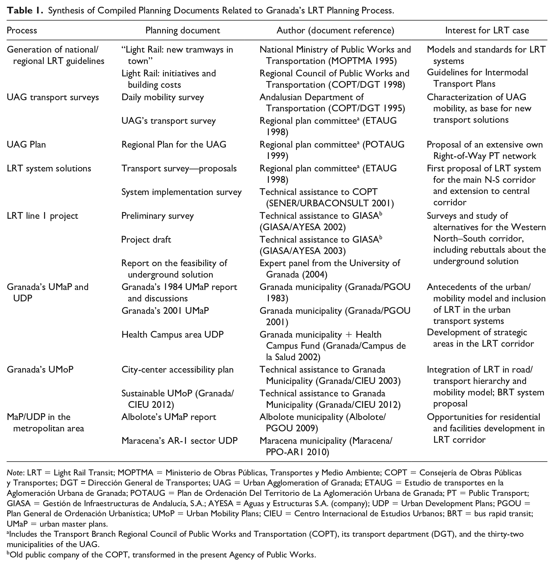
Note: LRT = Light Rail Transit; MOPTMA = Ministerio de Obras Públicas, Transportes y Medio Ambiente; COPT = Consejería de Obras Públicas y Transportes; DGT = Dirección General de Transportes; UAG = Urban Agglomeration of Granada; ETAUG = Estudio de transportes en la Aglomeración Urbana de Granada; POTAUG = Plan de Ordenación Del Territorio de La Aglomeración Urbana de Granada; PT = Public Transport; GIASA = Gestión de Infraestructuras de Andalucía, S.A.; AYESA = Aguas y Estructuras S.A. (company); UDP = Urban Development Plans; PGOU = Plan General de Ordenación Urbanística; UMoP = Urban Mobility Plans; CIEU = Centro Internacional de Estudios Urbanos; BRT = bus rapid transit; UMaP = urban master plans.
Includes the Transport Branch Regional Council of Public Works and Transportation (COPT), its transport department (DGT), and the thirty-two municipalities of the UAG.
Old public company of the COPT, transformed in the present Agency of Public Works.
Assessing planning through argumentation consisted of the ratification of the argumentative elements of the model (hypotheses, environments, representations . . .) in consulted documents. We considered two approaches, depending on the origin of arguments: analyze explicit arguments contained in a set of plans within the same institutional level, or analyze potential arguments, mixing argumentative elements from plans across multiple organizational contexts. The second was chosen, to cover different plans without any assumptions of hierarchy. This procedure also enabled more flexibility in the interpretation and exploration of planning ideas generated about the LRT and other transport interventions, establishing an open “dialogue” with the reviewed documents.
We followed six iterative steps for identifying different argumentative elements:
propose planning hypotheses (H) related to LRT images about capacity, demand, accessibility, and urban impacts (see “LRT Projects as Image Builders” section);
find specific contents—text, section, figures, maps—in planning documents related to each hypothesis;
establish the argumentation background, by connecting the previous planning products (P)—objectives, diagnostic, proposals . . .—to the planning environment (E)—systems, actors, key decisions . . .—making inferences about its main purpose when not clarified by documents;
use each assessment criteria (consistency, coherence, and plausibility) for considering the specific representations (R) and mechanisms (M)—argumentation field—that support the hypothesis in a given background;
reformulate the original hypothesis in nominal arguments, as short texts capturing the previous representations and mechanisms; and
propose alternative hypotheses (e.g., counterarguments and qualifiers), going back through the previous steps and addressing alternative backgrounds, fields, and assessment criteria.
Reformulation of hypotheses and arguments by this procedure branched in sixteen hypotheses and up to one hundred nominal arguments. In this paper, we only elaborate on those arguments representative of main backgrounds and fields of argumentation in building LRT images. For a full account of the identified arguments, see Navarro-Ligero (2020).
Argumentative Elements, Fields, and Backgrounds in the Assessment of Granada’s LRT Images
Backgrounds of Argumentation
LRT hypotheses emerge in four main argumentative backgrounds, connecting the review of planning products with different planning environments (see Table 2). Hypotheses about LRT improving accessibility and traffic conditions are related to metropolitan area formation and urban reforms backgrounds. Hypotheses involving impacts of LRT in transport system and urban development are found in LRT corridor design and LRT integration/transformation backgrounds.
Argumentation Backgrounds Related to Main Granada’s LRT Planning Hypotheses (Reviewed Documents in Table Footnotes).

Note: LRT = light rail transit; PT = public transport.
LRT project surveys.
Metropolitan transport/mobility surveys.
Agglomeration regional plan.
Granada mobility/accessibility plans.
LRT guidelines.
Urban master and development plans from municipalities.
Metropolitan-area formation backgrounds are central in the approval of the LRT project under the intermunicipal committee of the Granada’s urban agglomeration plan (POTAUG 1999). Previous transport-demand and mobility surveys informing the plan linked the formation of a metropolitan area to higher mechanized mobility rates, commuting patterns, and latent public transport demands. These surveys paved the way to proposals for improving public transport systems. The municipalities agreed a future public transport network that resembled the layout of the old regional tramway network between 1920s and 1930s. But the proposal adapted to a more prevalent image inherited by the POTAUG’s spatial model, where a future high-capacity road system would perform “articulating” functions. Accessibility and traffic improvements only seem realistic in an environment of integration of the LRT with road modes (private vehicle and bus systems). The agglomeration plan kept a multimodal approach to this own Right-of-Way (ROW) system (either bus or light rail), allowing more flexibility in future decisions.
City-center reforms backgrounds contextualize same hypotheses about accessibility improvement in earlier discourses on renewal and decentralization. Those emerged in 1980s debates around the new master plan for Granada, mixing concerns about traffic pressures with preserving the spatial identity of a historic center under abandonment risks. The use of transport infrastructures for defining the West border of the city faced a historical paradox: as plans proposed new north–south urban arterials to contain city spread and distribute traffic, pressures from developers to turn them into development belts increased. Decentralization became a matter of coordination of central city with other municipalities, under new regional plans and metropolitan transport projects. In practice, later municipal plans still used main north–south transport axis to promote disjointed urban operations in the West border. Traffic restriction policies and street hierarchy schemas, started in the 1990s, proved more effective in protecting the traditional center and neighborhoods from external traffic while enhancing their spatial identity. Furthermore, their positive impact on the use of public transport justified an overhaul of the public access system.
Medium-capacity corridor’s design backgrounds relate to hypotheses about the contribution of the LRT project to transport and access capacities. In environments of regional budget scarcity, public-infrastructure providers shared discourses promoting rational transport solutions, alternative to road expansion for automobile. Methodological guidance in Intermodal Transport Plans in Andalusia and assessment of early LRT implementation surveys use cost-efficiency criteria. The congestion of the previous bus system in the central corridor of Granada (Gran Vía—Avenida de la Constitución streets) was used to justify higher capacity solutions. But as priority was given to the undergrounded alternative in the West corridor (Camino de Ronda Street), the LRT started competing with an upgraded high-capacity line promoted by the bus company and integrated in the 2012 mobility plan. The agglomeration plan also tied future metropolitan extensions of LRT to feasibility studies, considering density and population sizes. With the advance of the line 1 project, local actors pursued new connections to the promised high-capacity system, allowing development areas adjacent to the project or upgrading the hierarchy of streets, roads, and public spaces, such as the Camino de Ronda area.
LRT’s urban integration backgrounds layout hypotheses about its potential urban transformations and impacts. The LRT project made its appearance in planning environments where its promoters were already participating in public–private development operations, such as the Health Campus/Technological Park Plan, or in agreements with other administrations for the intermodal link with the forthcoming high-speed rail station. LRT routes and sections were adjusted in most cases to existing urban project decisions. Environments of design for the line 1 survey generated products that showed occupancy, noise, and visual impacts of the different alternatives (routes, street sections, stations): multicriteria assessment processes, urban integration, and environmental reports. Detailed street remodeling (façade to façade) was conceived under urbanization projects. Public exposition of such products fueled debates about the underground solution and the associated traffic reforms in the central section (Camino de Ronda), requiring new expert reports that reconsidered integration factors (University of Granada 2004). The city mobility plan pushed a transport reform in the direction of combining line 1 of the LRT with more flexible and economic bus rapid transit (BRT) systems.
Fields of Argumentation
We explore four distinctive fields of argumentation connected to LRT hypotheses in planning documents: the first is related to innovations on transport-system capacities; a second strategic-spatial field complements the former; the third field involves traditional demand and traffic management, in connection with a fourth rational-analytic field. Each field entails different mechanisms and representations in which arguments contribute to the consistency, plausibility, and coherence of the hypotheses suggested in the previous backgrounds (see Table 3).
Fields of Argumentation in Granada’s LRT Arguments.
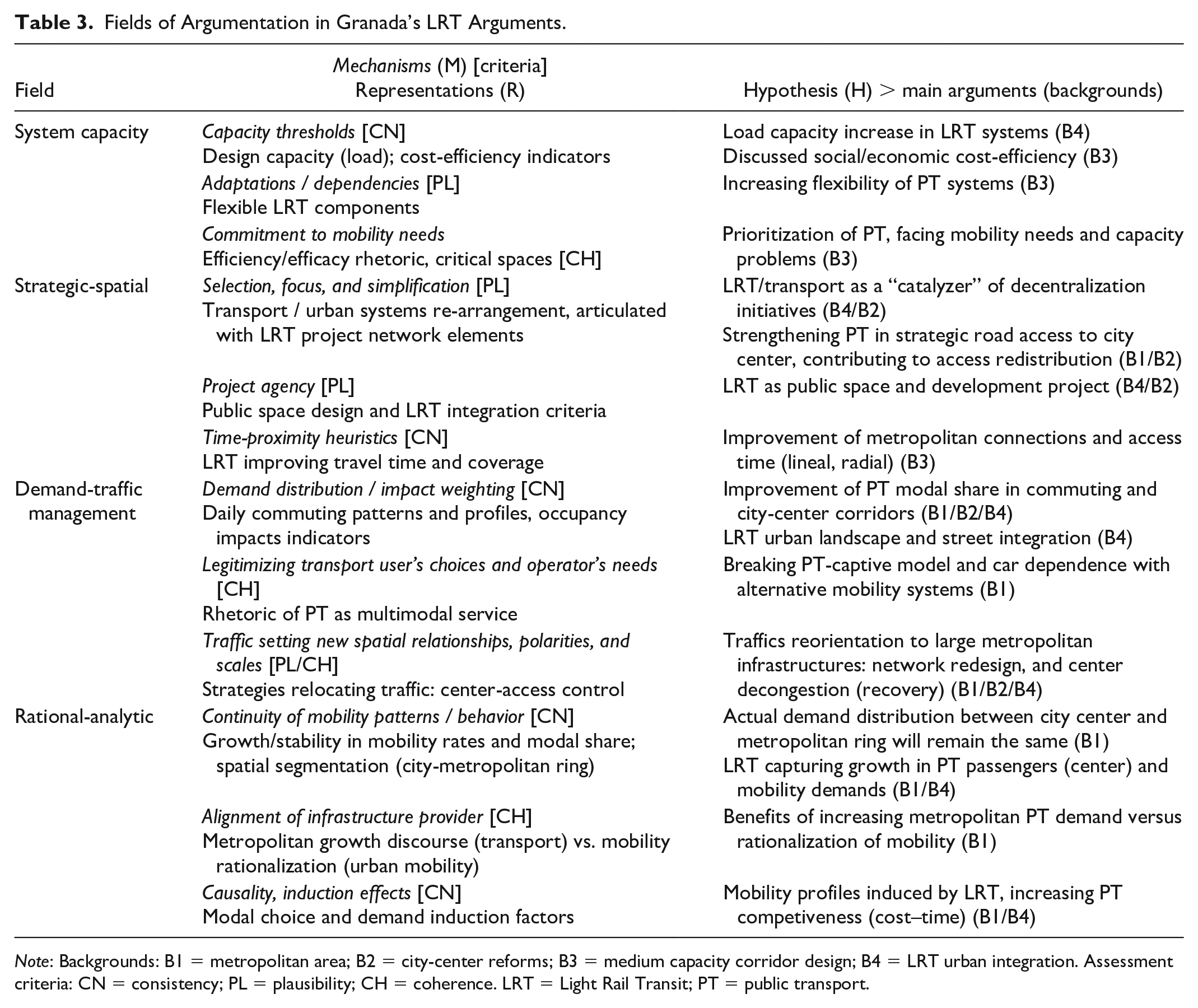
Note: Backgrounds: B1 = metropolitan area; B2 = city-center reforms; B3 = medium capacity corridor design; B4 = LRT urban integration. Assessment criteria: CN = consistency; PL = plausibility; CH = coherence. LRT = Light Rail Transit; PT = public transport.
The system capacity field was characteristic of public transport promoters in the background of corridor design and integration. Capacity threshold mechanisms based on urban and technical factors (urban density, street geometry . . .) give consistency to hypotheses about transport capacity improvements. Representations of design capacities and cost-efficiency indicators facilitated procedures for prescribing LRT systems in intermedium demand corridors. However, most LRT projects in Andalusia did not meet the regional guidelines. Arguments increasing plausibility involve adaptation and dependency mechanisms, enabling representations of relatively versatile design components (street integration, higher detour, and stop spacing tolerance) when planners invoke flexible capacities in comparing LRT with higher capacity systems (i.e., metro and regional rail). From the perspective of coherence, emphasizing representations of capacity and efficiency of transport in critical spaces for mobility, such as the city center and the metropolitan access corridors, strengthens arguments about the prioritization of public transport. These arguments pull mechanisms of institutional commitment to solve mobility and urban quality needs for citizens.
A strategic spatial field interprets capacity in a rather referential dimension across urban/metropolitan reforms and LRT design/integration backgrounds. Mechanisms selecting, re-ordering, and shifting transport network elements, as foci or spatial frames for urban and metropolitan initiatives, enhance the plausibility of arguments about indirect urban transformations of the LRT project (i.e., “catalyzing” effects). Planners used them in representing “decentralized centralization” strategies, land-use allocation criteria, and urban reform processes in the proximity of transport nodes or in strengthening public transport priority in strategic road access to city center. Transport analysis and models highlight improvements of travel time (global) and coverage (local), supporting consistency of proximity-based transformations. Agency is the main mechanism involved in arguments about direct transformations of the LRT project, as it becomes an actor in public space projects (e.g., urban renewal). Agency enables representation of high-level goals and motivations embodied in LRT programs and project procedures: multimodal mobility principles, urban integration goals in multicriteria assessment, infrastructure design criteria, and corrective environmental measures (e.g., noise prevention).
Demand-traffic management is another major argumentation field of the metropolitan reform background. It takes metropolitan mobility as the main object of concern. Distributional and weighting mechanisms of mobility are of high relevance in supporting the consistency of arguments about LRT impacts across different backgrounds: increase of the share of public/collective modes in commuting and city-center travel, and negative cityscape impacts represented by surface occupancy indicators (previously classified by function or vulnerability classes). Transport planners used arguments about spatial concentration of demand for redesigning the existing public transport corridors, fitting to the expected demand distribution. Coherence involves arguments that couple demand distribution with mechanisms legitimizing needs and choices from the diversity of metropolitan transport operators and their usual clients. Representations focus on daily commuting profiles (work, studies . . .) and attraction/generation centers. LRT implementation arguments stand for a “modal rebalance” through new mobility systems, breaking modal dependence in such captive mobility profiles. Plausibility and coherence in this field relate to arguments that use large infrastructures and traffic to suggest new spatial relationships and scales (e.g., metropolitan systems and actors). Mobility scenarios in plans and modeling exercises represent traffic relocation processes outside city center, with the LRT collecting mobility flows through North–South metropolitan corridors.
A rational-analytic field complements the previous distributional (i.e., weighting) rules, replacing intentional selective mechanisms of the strategic-spatial field by mechanisms of continuity. Consistency of demand arguments rests on the alleged ability of LRT system to capture the growth of public transport demand observed in internal and external (radial) connection to city center. Mobility simulations introduce representations based on the extrapolation of trends in mobility rates, modal shares, passenger growth rates, and spatial distribution (i.e., city vs. metropolitan ring). Demand models project changes in mobility behaviors triggered by LRT that also rely on preexisting mechanism, such as cost–time competence between private and public modes and parking availability. Mechanisms of causation join the previous, assuming the additional impacts of access restrictions (taking the 1997 measures as antecedent) and planned park-and-ride site. In augmenting coherence of argumentation, the LRT infrastructure provider aligns either with metropolitan planners or with urban mobility managers: the former, by identifying a functional metropolitan area with areas of high urban growth and density of mobility flows and, the later, by highlighting the need for rationalizing car mobility in the city center, where congestion impacts are higher.
Discussion: Implication of an Argumentative Approach for the Assessment of Images in Transport Planning
The aim of the paper was to develop an argumentative model able to capture different planning effects (first and second order), planning-assessment approaches (rational, communicative, and pragmatic), and image-building processes (instrumental and constitutional). Our interest was to adapt scenario methods to diverse argumentation fields and backgrounds in urban and transport planning. The application of our model to the Granada’s LRT case showed two groups of arguments in the construction of future images of LRT in related planning documents: (1) system-integration arguments, validating LRT functions against the image of a common metropolitan transportation system, and (2) spatial-integration arguments, validating LRT design against the image of an access system that adapts to multiple local conditions of the urban agglomeration (Table 4). The first group consolidates the frequent link between metropolitan and urban reform backgrounds with both rational analytic and demand-management fields (see previous section), most taking metropolitan mobility as a common object. The second group includes arguments that connect the background of urban/metropolitan reforms with the strategic-spatial field and the background of the LRT corridor design with the system capacity field, highlighting local critical spaces in both cases.
Main Arguments in Building Two Archetypal LRT Images in the Metropolitan Area of Granada.
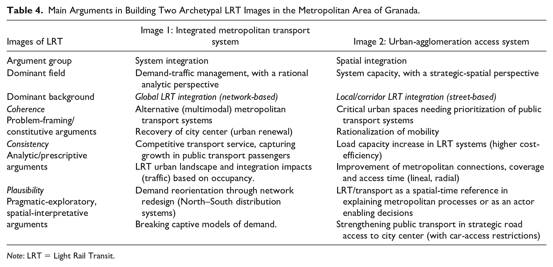
Note: LRT = Light Rail Transit.
System-integration arguments align well with the conformance-based approach (i.e., “plan-project”) of Spanish master-planning tradition, with their focus on building instrumental images of the future (i.e., physically deterministic and functionally closed) and demonstrating first-order effects: for example, rise of transport demand and integration of systems. Still, regional plans leave room for performance-based approaches. Despite municipal master plans must commit to the full-fledged images built by regional plans, the definition of such images requires previous consensus about principles and actions ((Valenzuela-Montes and Soria-Lara, 2012); Neuman 2012). In the Granada case, planners’ arguments on metropolitan demand emphasize systems—for example, road network—and trends—for example, mobility-demand rise—that are common to multiple actors (i.e., municipalities). In the practice of defining, selecting, and redesigning transport network elements, these arguments reinforce “planning doctrines” (Faludi 1996, 2000).
Spatial-integration arguments can be found in the context of newer mobility strategies. They use flexible planning concepts for reframing disjointed local realities and problems (e.g., reframing mobility as accessibility for city-center protection, or as intermodality for balancing modes), making ground for fostering actors’ collaboration (Mäntysalo and Grišakov 2017). Paradoxically, the well-defined images of project’s arguments (LRT street sections, routes, operation schemes . . .) are more effective anticipating system capacities (LRT system coverage, connections, load capacities . . .), complex actor’s dependencies, and boundary spaces across plans that create the need for collaboration. Projects’ materialities become intermediary actors themselves, enabling new decisions and perspectives onto existing elements of the urban space (Olesen and Lassen 2016).
Our model contributed to find complementary prescriptive, rhetorical, and pragmatic functions of planning arguments across the usual rational–communicative divide (Guyadeen and Seasons 2016). In doing so, the model did not preselect any theory or planning construct; we rather applied it as a heuristic tool that helped us to interpret what planners say, think, and do in response to a complex perception of the future. This exploratory approach could get the best from scenario techniques for quite different planning contexts, such as expanding the range of information sources (analytical and discursive, normative and non-normative, textual and visual . . .), structuring collaborative techniques into relevant topics, or pairing effective planning outcomes with comprehensive communicative strategies. The model may also support researchers in developing empirical methods for deconstructing planning processes under empirical approaches (e.g., Actor–Network Theory; see Nicolaisen and Olesen 2017).
Conclusion
Given the multiple approaches to planning assessment, how planners can assess images about the future? We offered an answer using an argumentative model and three assessment meta-criteria (consistency, plausibility, and coherence) that address the construction of instrumental images (product-ended) and constitutional images (process-ended). We apply this model to the review of hypotheses about the LRT in planning documents of the metropolitan area of Granada elaborated during its implementation.
Our argumentative model provides a framework for developing and communicating planning images open to different planning-assessment approaches. The identified arguments showed how planners simultaneously build instrumental images, anticipating conditions and goals for the implementation of plan solutions, and constitutional images, raising attention about critical spaces, conflicts, and opportunities that emerge under planning interventions. We hope the heuristic application of the model can serve as a step toward moving argumentation from theoretical policy analysis to practical “frame-reflective” exercises (i.e., scenario-building processes) that help planners and researchers in gradually improving their outcomes while addressing the proper audiences. Further work would be needed to convert model elements and criteria into a set of instrumental questions and procedures, proved in alternative planning traditions (i.e., plan-project and strategic).
Footnotes
Declaration of Conflicting Interests
The author(s) declared no potential conflicts of interest with respect to the research, authorship, and/or publication of this article.
Funding
The author(s) disclosed receipt of the following financial support for the research, authorship, and/or publication of this article: This work has been supported by the PhD Program on Civil Engineering of the University of Granada (Spain), for the Thesis dissertation of the corresponding author, titled Evaluación de escenarios para la planificación del transporte y el desarrollo urbano: aplicación al metro ligero de Granada [Scenario assessment for transport planning and urban development: an application the light rail project of Granada]. Also, by the State Research Agency of Spain, under a postdoctoral “Juan de la Cierva” training grant (FJC2020-044618-I / AEI / 10.13039/501100011033).
