
Abstract
The north Patagonian region between 38° and 42°S extends along the proximity of two major atmospheric circulation features in South America: the northern border of the southern westerly circulation belt, and the northeast trade wind circulation associated with the subtropical South Atlantic Anticyclone. The influence of this westerly wind system determines the annual and seasonal precipitation regimen in north Patagonia, while the influence of the South Atlantic Anticyclone is more pronounced towards the east. The changing strength of either of these circulation systems has had a strong influence on Holocene environmental change in the region. Palaeoenvironmental changes are inferred from a 500 cm long core from Bajo de la Quinta, (40°55'42"S, 64°20'19"W) by means of pollen, sediment and geomorphological analyses. A dry phase with westerly winds during the middle Holocene, at around 7000–6600 cal. yr BP, is indicated by xerophytic/psammophytic vegetation and Patagonian steppe components. Between 6600 and 5200 cal. yr BP the pollen record reflects shrub steppe vegetation and low values of long distance transported pollen indicates little influence of the westerly winds. Between 5200 and 2900 cal. yr BP very arid conditions are indicated by high pollen values of Ephedra sp. and Nassauvia sp. and westerlies influenced by long distance pollen types such as Nothofagus sp. In the late Holocene (2900 cal. yr BP) the pollen record shows an increase in typical shrub taxa of the Monte and Espinal vegetation and low influence of long distance taxa. This may suggest a change to semi-arid conditions that persisted until the present, where the shrub steppe is the dominant vegetation. The environmental and geomorphological changes that occurred during the middle and late Holocene had influenced the space and resources used by hunter-gatherers of the area.
Keywords
Introduction
The north Patagonian region between 38° and 42°S is extended along the proximity of two major atmospheric circulation features in South America: the northern border of the southern westerly circulation belt, and the northeast trade wind circulation associated with the subtropical South Atlantic Anticyclone (Schäbitz and Liebricht, 1998). The Southern Hemisphere Westerly Winds (SWW) constitute an important zonal circulation that influences large-scale precipitation patterns and ocean circulation (Garreaud et al., 2009). Variations in their intensity and latitudinal position have been suggested by some researchers as a primary driving force for precipitation and vegetation changes during the Holocene (Fletcher and Moreno, 2011; Heusser, 1995; Lamy et al., 2010; McCulloch and Davies, 2001; Markgraf, 1993; Mayr et al., 2007; Moreno, 2004; Toggweiler et al., 2006; Varma et al., 2010).
In north Patagonia, the preponderance of westerly circulation determines the annual precipitation (Schäbitz and Liebricht, 1998). Also, the changing dominance of the westerlies together with the Atlantic air masses from the northeast influence the seasonality of precipitation. Maxima during winter are characteristic in the southwest, whereas the maxima in the northeast of Patagonia occur during spring and autumn, when more humid air from the east spreads over the continent (Schwerdtfege, 1976). A strong west–east precipitation gradient establishes and drives important vegetation changes from the Andes to the Atlantic coast (Hueck and Seibert, 1981). In the west, Sub-Antarctic forest follows at the foot of the Andes with Nothofagus communities and towards the east, with Austrocedrus communities. To the west-centre, vegetation changes to Patagonian steppe type with grasses and dwarf shrubs such as Nassauvia and Mulinum. To the southeast of the Río Negro province, xerophytic Monte vegetation is present, with a predominance of Larrea shrub species. The Monte vegetation limits to the north with the Espinal, characterized by different Prosopis species, Condalia microphyla and Schinus sp. (Roig, 1998).
Palaeoecological records suggest that the environmental conditions have changed during the middle Holocene in north Patagonia. Muhs and Zárate (2001) and Markgraf (1993) have inferred warm and wet conditions, while climate models (COHMAP) suggest cold and dry or dry conditions in the eastern Andes during the same period (Collins et al., 2006; Whitlock et al., 2006, respectively). Other studies have postulated an intensification of the westerlies (Grimm et al., 2001; Mancini et al., 2005; Markgraf, 1993) and a shift to semi-arid conditions during middle–late Holocene (Schäbitz, 1994, 1999, 2003).
In northeastern Patagonia, palaeoecological reconstructions were performed by Schäbitz (1994, 1999, 2003) within the Espinal Biogeographic Province and by Schäbitz and Liebricht (1998) in the Patagonian Steppe. Palaeoenvironmental data for the coastal region of Río Negro province is still scarce.
Environmental changes occurred during the Holocene have influenced human occupations in Patagonia, in particular owing to changes in resources availability and land-use strategies over time (Mancini, 1998, 2002). In this sense, this study is an original contribution to the understanding of North Patagonian environmental changes, the reconstruction of past scenarios and the way these changes have influenced human activities during the middle–late Holocene.
The aims of this study are (1) to reconstruct the environmental history of the study area and its relationship with human occupations since the middle Holocene; and (2) to compare the palaeoenvironmental information obtained with other records, in order to infer the regional environmental changes of Northeast Patagonia.
Site descriptions
Bajo de la Quinta (40°55'42"S, 64°20'19"W) is located on the northern coast of San Matías Gulf, Rio Negro province (Figure 1). This flat depression, locally known as Bajo, was originated by fluvial processes and deflation. Nowadays, ephemeral streams drain the Bajo de la Quinta basin, but this drainage towards the coast is impeded by the Holocene beach ridges and dunes resulting in the formation of an ephemeral lake. Towards the coast there are littoral ridges, flanked by active cliffs (Favier Dubois and Kokot, 2011).
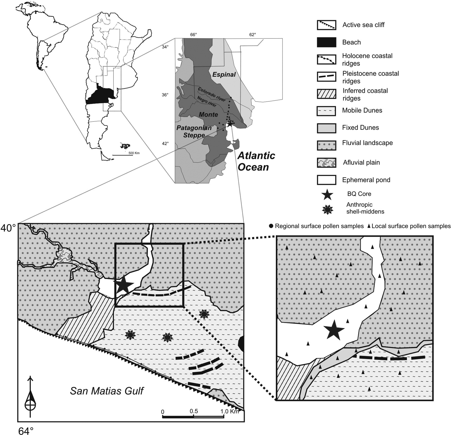
Map showing the location of Bajo de la Quinta area, geomorphological units (modified from Favier Dubois and Kokot, 2011), location of local surface pollen samples, regional surface pollen samples, anthropic shell-middens and the site of BQ core.
The mean annual temperature in northeastern Río Negro is about 12°C and annual precipitation varies from southwest to northeast between 100 and 350 mm (Labraga and Villalba, 2009). The regional vegetation is characterized by shrubland communities, belonging to the Monte Biogeographic Province (Figure 1) (Abraham et al., 2009; Roig et al., 2009; Roig-Juñent et al., 2001).
The dominant species is Larrea divaricata, a xerophytic shrub forming the ‘jarillal’ associated with Prosopis alpataco, Monttea aphylla, Condalia microphylla, Senna aphylla and Chuquiraga erinaceae. Chenopodiaceae shrubs (Atriplex lampa and Suaeda divaricata) dominate in salty soils in depressions (León et al., 1998).
The Monte shrub communities are organized as a two-phase mosaic composed by a phase of perennial grasses and shrub-dominated patches alternating with sparse cover (Ares et al., 2003; Bertiller et al., 2004; Bisigato et al., 2009). The predominant geoforms of Bajo de la Quinta (Mobile and Fixed Dunes, Fluvial Landscape and Ephemeral Lake) and soils in this landscape determine the spatial heterogeneity of vegetation ranging from psammophytic communities to shrublands, in relation to effects on water availability and edaphic conditions.
Around Bajo de la Quinta the vegetation is differentiated in four communities according to morphological units. The psammophytic community is dominated by Hyalis argentea and Sporobolus rigens. This community is located in Mobile Dunes, and the sand mobility is the dominant factor that determines the species composition. The psammophytic-shrubs steppe transition, represented in Fixed Dunes unit, is characterized by Larrea divaricata, Capparis atamisquea, Prosopis alpataco, Ephedra ochreata, Cereus aethiops, Condalia microphylla, Sporobolus rigens and Hyalis argentea, among others. The shrub steppe, dominated by Larrea divaricata, is developed in Fluvial Landscape unit. Other shrubs, such as Geoffroea decorticans, Condalia microphylla, Capparis atamisquea, Monttea aphylla and Chuquiraga erinaceae, are some of the diagnostic species growing in this unit. Finally, the grass steppe from Ephemeral Lake is dominated by Poa ligularis and Stipa tenuis. Other herbs, such as Hoffmanseggia glauca, Senecio subulatus and Grindelia chiloensis, also occur in this unit.
The archaeological sites in Bajo de la Quinta are located in the dunes at a distance up to 2 km away from the sediment sequence recovered for pollen analysis (Figure 1). These sites are characterized by the presence of anthropic shell-middens located in dunes developed over marine terraces; they spread over a large distance from the present shoreline. The shell-middens contain abundant lithic artifacts and faunal remains (marine and terrestrial), corresponding to hunter-gatherer occupations developed since the middle Holocene. Human remains recovered here have been important to establish an isotope (δ13C and δ15N) paleodietary tendency for this coastal region, in which the use of marine resources diminished through time. During the early stage of human occupation (c. 6000 to c. 2200 14C yr BP), the intensive exploitation of marine fauna, particularly fish and seals, is evidenced for a predominantly maritime diet. For the late stage (between c. 1700 and c. 450 14C yr BP) a noticeable diminution of human dependence on marine species, and an increased consumption of terrestrial fauna as guanaco (Lama guanicoe) and rhea (Rhea americana) were recorded (Favier Dubois et al., 2009).
Methods
A core of 500 cm long was obtained using a percussion drilling corer. The stratigraphy of the core was based on lithological description and analysis of organic matter and carbonate content by loss-on-ignition (LOI) on the same levels analyzed for pollen. For organic matter and carbonate content, sediments were oxidized at 500–550°C to carbon dioxide and ash. Later, carbon dioxide evolved from carbonate at 900–1000°C, leaving oxide (Bengtsson and Enell, 1986; Heiri et al., 2001). Results are expressed as percentages of weight loss of the sediment in each step related to the dry weight of the samples before combustion (Heiri et al., 2001). Pollen analysis was carried out in the BQ core at 4 or 8 cm intervals (N=66 samples). In addition, local and regional surface samples were analyzed to help interpret the fossil pollen record. Local surface samples (N=26) were collected from the main geomorphological units present in the area: Mobile Dunes, Fixed Dunes, Fluvial Landscape and Ephemeral Lake (Marcos and Mancini, 2012). And, 18 surface samples were taken from different vegetation units of the region: Monte-Espinal, Monte and Monte-Patagonian Steppe (Figure 1). Sediment samples (modern and fossil) were processed according to standard palynological techniques including hot KOH, HCl, heavy-liquid with ZnCl2, HF and acetolysis (Faegri and Iversen, 1992; Gray, 1965) at National University of Mar del Plata (Laboratory Palaeoecology and Palynology). Three Lycopodium clavatum tablets were added to every weighted sample before treatment to estimate representative pollen sums and pollen concentration. The samples were analyzed under light microscope by counting at least 300 grains. Identifications and counting were performed using the pollen reference collection of the Laboratory of Paleoecology and Palynology. Terrestrial pollen percentages were based on the sum of shrubs, dwarf-shrubs, grass and herbs. Each taxon is expressed as a percentage of the total pollen sum. The pollen of Rumex sp. (Disturbance taxa) was excluded from the pollen sum since their spatial distribution is related to disturbed areas. Eucalyptus sp., Asteraceae subf. Cichorioideae, Brassicaceae and Pinus sp. pollen taxa were also excluded from the pollen sum because they represent no native species. Additionally, Geraniaceae, Plumbaginaceae, Rosaceae, Convolvulaceae, Ranunculaceae and Malvaceae with low representation were grouped and called as ‘herbs’. Pollen diagrams were plotted using TILIAGRAPH (TGView, 2.0.2, Grimm, 2004). The zonation of the fossil sequence was performed with the aid of a stratigraphically constrained cluster analysis (CONNIS, Grimm, 2004). Local surface-fossil pollen samples and regional surface-fossil pollen samples were ordinated by Detrended Correspondence Analysis (DCA). Statistical analyses were performed to determine whether the local and/or regional surface samples are associated with the fossil samples. All taxa included in the pollen sum exceeding 1% in any modern and fossil sample, as well as long distance taxa were included in the analysis. Eucalyptus sp., Brassicaceae, Rumex sp. and Asteraceae subf. Cichorioideae were excluded because they do not represent the native vegetation or are related to disturbed areas. Chenopodiaceae was also excluded because of an overrepresentation in some samples.
Palynological richness was calculated on modern and fossil pollen samples using the rarefaction technique in order to better understand vegetation dynamics. This analysis was performed with Psimpoll 4.10 (Bennett, 2003) and provides estimates of the expected number of pollen taxa (E(T n )), given that all pollen counts were the same size (Birks and Line, 1992). The rarefaction analysis of the modern (local and regional samples) and fossil pollen data was based on 210, 230 and 235 grain minimum pollen sum, respectively.
Chronological control of the sediment record and the archaeological sites were obtained by radiocarbon dating by accelerator mass spectrometry (AMS). Radiocarbon dates were calibrated using CALIB 5.0.2 software (Stuiver and Reimer, 1993; Stuiver et al., 2005). The Southern Hemisphere (SHCal 04) calibration curve (McCormac et al., 2004; Reimer et al., 2004) was applied during the calibration of continental samples, while for marine samples the MARINE09 curve was used (Reimer et al., 2009). The chronology of Bajo de la Quinta core is base on four radiocarbon dates on bulk sediment and shell (Table 1a). An age–depth model was constructed by MCAge software using a cubic smoothing spline and a bootstrap approach (Monte Carlo sampling) that allowed each date to influence the age model through the probability density function of the calibrated ages (Higuera et al., 2008, 2009). The final chronology represents the mean age of each depth from all the runs (Figure 2).
Radiocarbon and calibrated ages from BQ core.
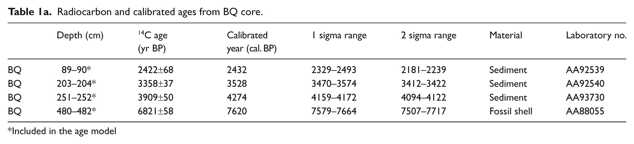
Included in the age model
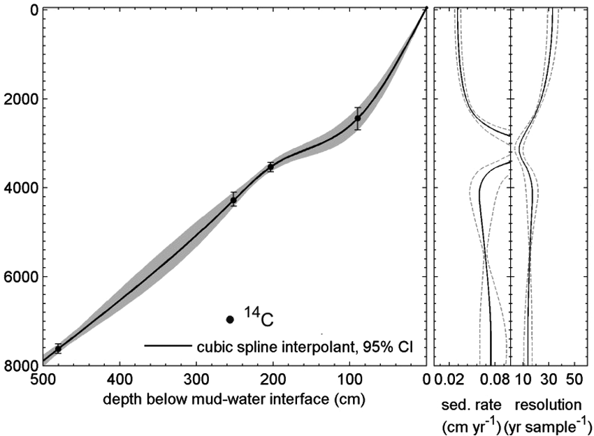
Age–depth curve based on four calibrated AMS radiocarbon dates from Bajo de la Quinta. Error bars represent two standard deviations and the grey zone the 95% confidence intervals.
Fossilized otoliths, mollusks and charcoal from archaeological sites developed on marine terraces were dated for establishing the chronology of main coastal scenarios of past human occupation (Table 1b). The global ΔR= 0 was used in the case of otoliths, and a ΔR= −134
Radiocarbon and calibrated ages from fossilized mollusks, otoliths and charcoal from archeological site of Bajo de la Quinta (modified from Favier Dubois and Kokot, 2011). CALIB 5.0.2 (Stuiver and Reimer, 1993; Stuvier et al., 2005), for marine samples a local reservoir effect value of 266+51 yr (Δ R= −134+51) was used (Favier Dubois, 2009).

Results
Local modern pollen assemblages
Pollen assemblages indicate the presence of four groups (Figure 3), which are related to local geomorphologic units and vegetation communities, see Figure 1.
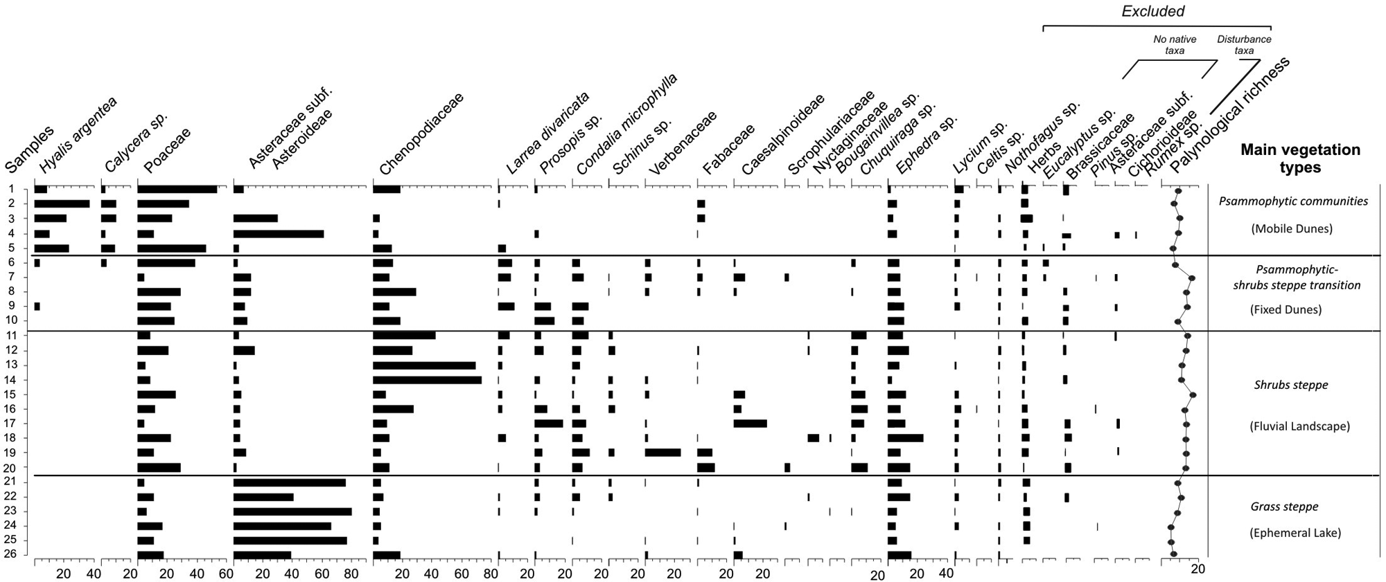
Local surface pollen diagram (in percentage) and palynological richness. Samples are plotted by vegetation communities from Bajo de la Quinta: Psammophytic communities, Psammophytic communities-shrub steppe transition, Shrub steppe and Grass steppe.
The Psammophytic communities are characterized by high percentages of Hyalis argentea (10–35%) and Poaceae (10–55%) together with Calyceraceae (5–10%), Chenopodiaceae (5–15%) and Asteraceae subf. Asteroideae (5–60%). Among shrubs, pollen of Larrea divaricata, Prosopis sp., Fabaceae and Ephedra sp. are present (5%). The lowest value (E(Tn)) was 7.67 with ranges between 6 and 9 pollen types (Marcos and Mancini, 2012).
The Psammophytic-shrub steppe transition is characterized by high values of Poaceae (5–40%), Chenopodiaceae (10–25%) together with moderate percentages of Larrea divaricata and Prosopis sp. (5–10%). Other shrubs frequently present are Asteraceae subf. Asteroideae, Condalia microphylla, Schinus sp., Verbenaceae, Fabaceae, Caesalpinoideae, Scrophulariaceae, Nyctaginaceae. The psammophytic taxa (Hyalis argentea and Calycera sp.) are also present. (E(Tn)) reaches values around 20 pollen types, the lowest value was 13 (Marcos and Mancini, 2012).
The Shrub steppe is characterized by entomophilous shrub pollen taxa such as, Larrea divaricata (3–7%) and Prosopis sp. (5–18%) together with other shrubs such as Condalia microphylla (5–10%), Schinus sp. (5%), Verbenaceae (usually <5% with 20% in only one sample), Caesalpinoideae (5–20%) and Chuquiraga sp. (5–10%). Chenopodiaceae reaches values up to 75% throughout the group. Poaceae shows values of 5–30%. The lowest value of (E(Tn)) was 9 with values that range between 15 and 20 pollen types (Marcos and Mancini, 2012).
Grass steppe is dominated by pollen of Asteraceae subf. Asteroideae (80%) and Poaceae (5–15%). Chenopodiaceae occurs with values of 5–10%, except in one sample with 20%. Shrubs such as Larrea divaricata, Prosopis sp., Rhamnaceae, Schinus sp., Verbenaceae, Fabaceae, Caesalpinoideae, Scrophulariaceae, Nyctaginaceae, Bougainvillea sp., Chuquiraga sp. and Lycium sp. are present with low values (<5%). Ephedra sp. reaches values of about 5–20%. The lowest value of (E(Tn)) was 8 with a range of pollen types between 7 and 10 (Marcos and Mancini, 2012).
Regional modern pollen assemblages (Figure 4)

Regional surface pollen diagram (in percentage) and palynological richness showing three groups according to sample’s location (north–south) from Río Negro province: Monte-Espinal, Monte, Monte-Patagonian Steppe.
Three groups (Monte-Espinal; Monte; Monte-Patagonian Steppe) were classified according to sample distribution (north–south), see Figure 1.
The Monte-Espinal is characterized by Condalia microphylla (15–20%), Schinus sp. (7–25%) and Prosopis sp. (10–20%). Other shrubs such as Chuquiraga sp. (5–15%), Caesalpinoideae (3–20%), Lycium sp. (2–7%) and Chenopodiaceae (5–20%) are present. Larrea sp. pollen values are low (<5 %). Poaceae (15–30%), Cyperaceae (2–15%) and other herbs such as Malvaceae, Geraniaceae, Plumbaginaceae, Rosaceae (5–7%) are also characteristic of this vegetation unit. The lowest value of (E(Tn) was 6 with a range of pollen types between 6 and 9.
Samples from Monte are characterized by Larrea sp. (2–15%), accompanied by Prosopis sp. (3–15%), Chuquiraga sp. (1–15%), Condalia microphylla (7–10%) and Schinus sp. (2–15%). Other shrub pollen taxa present are: Geoffroea sp. (5–10%), Lycium sp. (<5%), Ephedra sp. (10–15%) and Asteraceae subf. Asteroideae (5–20%). Chenopodiaceae shows variable values (5–70%). Long distance taxa such as Nothofagus sp. and Podocarpus sp. present low values (<5%). Among the herbs, Poaceae (15–45%), Cyperaceae (<5%) together with Geraniaceae, Plumbaginaceae, Convolvulaceae, Ranunculaceae (<10%, plotted as ‘herbs’) are the most representative. The lowest value of (E(Tn) was 2 with a range of pollen types between 2 and 11.
The Monte-Patagonian Steppe is characterized by Ephedra sp. (25%) together with Nassauvia sp. (7–10%), Larrea sp. (5%), Prosopis sp. (6%) and Chuquiraga sp. (<5%), among others. The herbaceous layer is represented by Poaceae (15–20%) and ‘herbs’ such as Malvaceae, Geraniaceae, Plumbaginaceae (<5%). The long distance taxa (Nothofagus sp. and Podocarpus sp.) present values of 7% and 10%, respectively. The lowest value of (E(Tn) was 6 with a range of pollen types between 6 and 10.
Fossil record
Stratigraphy
The core sedimentary characteristics allow three sections to be differentiated: 0–230 cm depth, 230–330 cm depth and 330–500 cm depth (Figure 5). The lowermost section (330–500 cm depth) is composed of fine sand beach sediments with low values of organic matter (<5%), carbonates (20–35%) and total pollen concentration (5×10³ g/gr). Additional samples obtained with a drill showed the presence of medium grain sandy sediments and fragments of marine mollusks below 500 cm depth, indicating a beach environment. The middle section (230–330 cm depth) is composed of silty sand sediments and has abundant gypsum concretions. It would correspond to estuarine or fluvial deposits under strong alternating wet and dry conditions. Organic matter presents values between 3 and 6%, carbonates (40%) and total pollen concentration increase (9–15 × 103 g/gr). The topmost section (230–0 cm depth) is composed by laminated clayed silt sediments which correspond to lacustrine deposits. Organic matter presents moderate values about 10% and total pollen concentration increases between 7 and 20 × 103 g/gr whereas carbonate values remain low (5–25%). The mean sedimentation rate along the sequence is around 0.02 (cm/yr). The entire profile shows a regressive sequence from marine and transitional environments (estuarine) to a continental environment, dominated first by fluvial processes and later by lacustrine layers which indicate the interruption of drainage and the edge of the pond dynamics towards the top of the column (Favier Dubois and Kokot, 2011).
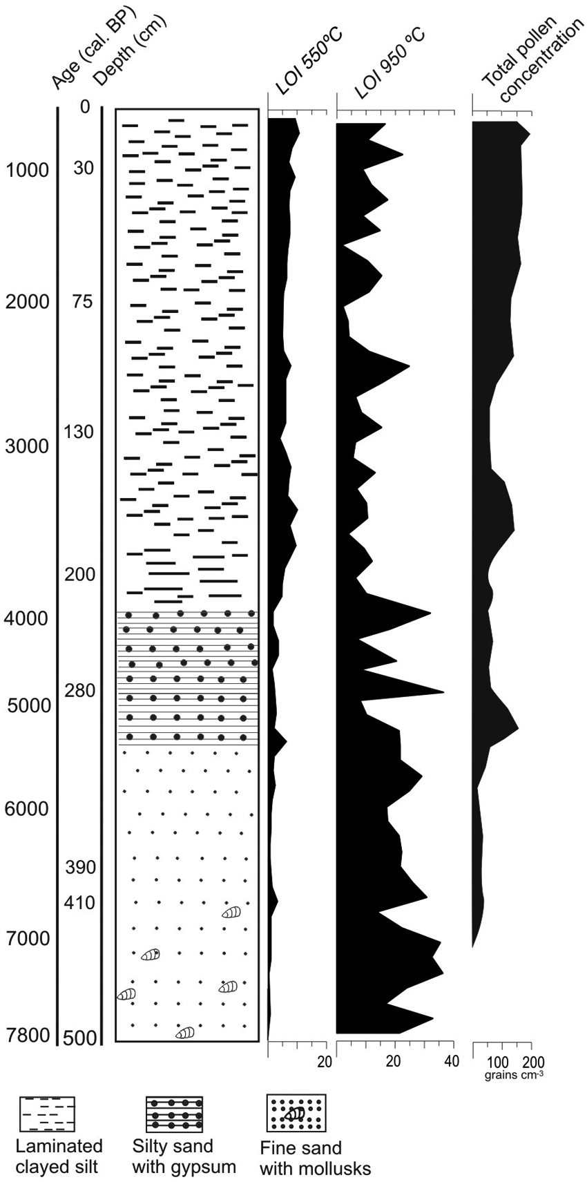
Stratigraphic column, along the calibrated ages and results of the loss-on-ignition analysis and total concentration.
Fossil pollen record (Figure 6)
Between 500 and 440 cm depth (7800–7000 cal. yr BP) the zone is palynologically barren. The presence of fine sand and marine mollusks (Tellina petitiana) indicate marine influence, which could be the cause of the absence of pollen in this period. The maximum phase of the middle-Holocene marine transgression has been recorded at Bajo de la Quinta (Favier Dubois and Kokot, 2011). During this phase the sea penetrated through the Pleistocene spits, flooding the basin (see Figure 1).

Pollen percentage diagram of BQ core, pollen zones according to CA, depth, age cal. BP and palynological richness.
According to cluster analysis the pollen sequence was divided into six zones, and zone 2 into subzones 2a and 2b.
Zone 1. (440–400 cm depth ~ 7000–6600 cal. yr BP) is characterized by pollen of Ephedra sp. (5–40%) and Prosopis sp. with values decreasing from the base (10%) to the top (5%) of the zone, accompanied by Chuquiraga sp. and Poaceae which increase towards the top (5–20% and 20–80%, respectively). Nothofagus sp. (10–25%) pollen are also present. Other shrub pollen taxa occur in some samples with low values: Larrea divaricata, Condalia microphylla, Fabaceae, Lycium sp., Nassauvia sp., Asteraceae subf. Asteroideae. Among the psammophytic/halophytic taxa with low values, Hyalis argentea., Calyceraceae and Chenopodiaceae are present. The lowest value of (E(Tn) was 3 with a range of pollen types between 3 and 6.
Zone 2a. (400–300 cm depth ~ 6600–5200 cal. yr BP). This zone is characterized by a decrease in pollen values of Chuquiraga sp. (10%), Ephedra sp. (2–10%), Asteraceae subf. Asteroideae (<5%) and Poaceae (20–30%) and an increment of Larrea divaricata (5–10%), Prosopis sp. (15%), Condalia microphylla (2–15%), Fabaceae (5–15%) and Geoffroea sp. (10–50%) respectively to the previous zone. Other shrubs are present: Lycium sp. and Nassauvia sp., Nothofagus sp. and Podocarpus sp. pollen are recorded in this zone, also with low values (2% and 5%, respectively). The lowest value of (E(Tn) was 3 with a range of pollen types between 3 and 8.
Zone 2b. (300–200 cm depth ~ 5200–3500 cal. yr BP) is characterized by an increase in pollen of Larrea divaricata (5–15%), Caesalpinoideae (15–25%), Lamiaceae (2–20%), Ephedra sp. (5–20%), Nassauvia sp. (5–15%), Nothogafus sp. (5–20%) and Podocarpus sp. (2–10%). Pollen values of Prosopis sp. (5–10%) are lower than those of the previous zone. Other shrubs present are: Condalia microphylla, Chuquiraga sp., Fabaceae, Lycium sp., Schinus sp. Among the herbs, Poaceae pollen dominates (10–40%), while other herbs (e.g. Geraniaceae, Plumbaginaceae, Malvaceae) occur with values of 5%. Chenopodiaceae are present with values of 5–20% while Hyalis argentea are present in a few samples with low values (2%).The lowest value of (E(Tn) was 3 with a range of pollen types between 3 and 8.
Zone 3. (200–135 cm depth ~ 3500–2900 cal. yr BP) pollen values of Prosopis sp. increase towards the top of this zone (5–30%) accompanied by Chuquiraga sp. (10–20%), Ephedra sp. (15–25%), Nassauvia sp. (10%) and Nothofagus sp. (10–15%). Larrea divaricata occur with low values (<5%). Condalia microphylla (7–20%), Caesalpinoideae (15–35%), Monttea aphylla (7–20%) and Geoffroea sp. (5–15%) are present with higher values than in zone 2b. The herb layer is characterized by Poaceae (10–35%) and other herbs such as Plumbaginaceae, Geraniaceae and Malvaceae (5%). The lowest value of (E(Tn) was 4 with a range of pollen types between 4 and 9.
Zone 4. (135–75cm depth ~ 2900–2000 cal. yr BP) This zone is characterized by the highest pollen values of Larrea divaricata (5–20%), Condalia microphylla (10–20%), Chuquiraga sp. (5–25%), Schinus sp. (5–25%) and Cyperaceae (5–25%). Prosopis sp. (5–25%) and Ephedra sp. (5–15%) values are lower than those of the previous zone. Long distance pollen of Nothofagus sp. and Podocarpus sp. are absent whereas Celtis sp. reaches values of up to 20%. Poaceae (20–40%) and other herbs (5–10%) are also present. The lowest value of (E(Tn) was 4 with a range of pollen types between 4 and 9.
Zone 5. (75–35 cm depth ~ 2000–1000 cal. yr BP) is characterized by the lowest values of Larrea divaricata <5%. Pollen of Prosopis sp. is present with fluctuating values (5–25%). Chuquiraga sp. values decrease (10–15%) in relation to the previous zone. Condalia microphylla decreases from 10% to 5% towards the top of this zone, while pollen values of Ephedra sp. and Poaceae increase from 10% to 50%, and 20% to 50%, respectively. Fabaceae, Lycium sp., Caesalpinoideae, Bougainvillea sp. and Monttea aphylla are present with moderate percentages. The lowest value of (E(Tn) was 4 with a range of pollen types between 4 and 9.
Zone 6. (35–0 cm depth ~ 1000–0 cal. yr BP) This zone is characterized by the highest pollen of Ephedra sp. (10–50%) and Asteraceae subf. Asteroideae (5–70%) recorded throughout the sequence. Larrea divaricata (5%) is present with low but constant values while Prosopis sp., Condalia microphylla, Fabaceae, Lycium sp. and Monttea aphylla pollen percentages increase slightly in relation to Zone 5. Poaceae occurs with values of approximately 30%. Nothofagus sp. and Podocarpus sp. are present at the beginning of the zone with values of 5–10%. The lowest value of (E(Tn) was 3 with a range of pollen types between 3 and 9.
DCA of Bajo de la Quinta local-fossil samples and regional-fossil samples
In order to determine the relationship between local pollen samples (N=26) and the fossil record (N=58), a DCA was performed (Figure 7a and b). The first two axes (eigenvalues 0.14 and 0.12) explain 12.79% and 11.76% of the total variance, respectively. The results show that all fossil samples were arranged with the Fluvial Landscape group. Only a few fossil samples are grouped with Fixed Dunes, this may be related to the fact that Fixed Dunes share many taxa with Fluvial Landscape. The fossil samples do not show relation to Ephemeral Lagoon and Mobile Dunes samples. These units capture the local signal of the vegetation and Bajo de la Quinta fossil record may reflect the regional signal. For this reason, samples from BQ core (N=58) were combined with regional modern samples (N=18) using DCA (Figure 7c and d). The first two axes (eigenvalues 0.23 and 0.11) explain 15.31% and 12.43% of the total variance, respectively. This analysis shows that the fossil samples have modern counterparts. The transition Monte-Espinal and Monte Patagonian Steppe communities can be inferred on the basis of modern pollen assemblages.
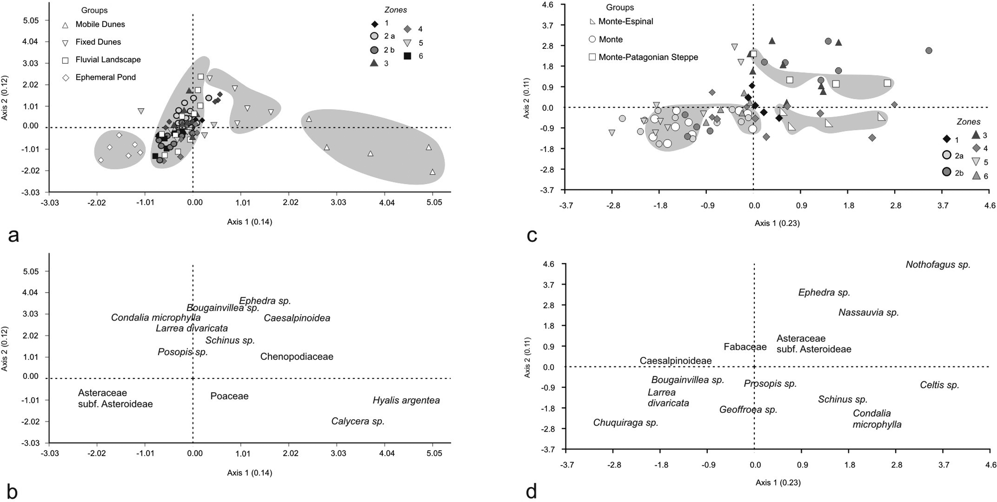
(a) DCA of combined local pollen samples and fossil pollen samples from BQ core. (b) Pollen variable scores. (c) DCA of combined regional pollen samples and fossil pollen samples from BQ core. (d) Pollen variable scores.
Subzone 2a, Zone 5 and 6 have been arranged close to the Monte group, this can be explained by the presence of taxa Monte in the lower left quadrant of the axis 1 and 2. Zone 4 shows similar pollen composition to the surface samples from the Espinal group located in the lower right quadrant of the plot. Subzone 2b and zone 3 have been ordinated close to Monte-Patagonian Steppe explained by Nassauvia sp. and Ephedra sp. in the upper right quadrant. However, some samples were grouped with the Monte group because of relatively high values of Larrea divaricata. Zones 1 and 6 do not show a clear ordering with respect to modern pollen assemblages. These zones would indicate a shrub steppe with Patagonian Steppe or Espinal influence.
The vegetation of these arid environments is mostly characterized by entomophilous species, with low pollen production, so pollen values of the most representative taxa do not show significant changes. In this sense, the associations between them, the influence of long distance taxa and/or taxa of neighboring vegetation units allow to elucidate environmental changes occurred in the past.
Discussion
Palaeoenvironmental interpretations
The interpretation of the fossil sequence allowed reconstructing the environmental history of Bajo de la Quinta. Geomorphological evolution indicates the combination of both fluvial and wind dynamics since the middle Holocene.
During the middle Holocene, between 7000 and 6600 cal. yr BP, the pollen assemblages indicate xerophytic/psammophytic vegetation; arid condition and influence of steppe are inferred by high values of Ephedra sp. and moderate values of Nassauvia sp. Long distance pollen such as Nothofagus sp. suggest intense westerly winds during this time. Thus, the very dry environmental characteristics of Bajo de la Quinta may indicate a shortage of land resources by hunter-gatherers inhabiting this region. This situation may have led to the exploitation of marine resources in this period. Between 6600 and 5200 cal. yr BP the pollen record reflects shrub steppe vegetation, represented by pollen of Larrea divaricata, Prosopis sp., Condalia microphylla and Chuquiraga sp., among others. Little influence of the westerly winds is inferred from low or zero values of Nothofagus sp. and Podocarpus sp. The silty sand sediment with gypsum concretions would be associated with dry environmental conditions. Wet–dry cycles in the sedimentary environment would lead to increased evaporation and subsequent formation of gypsum crystal (Horowitz, 1992). This shows a clear relationship with arid environmental conditions, also inferred from pollen records for this period. At the end of the middle Holocene (5200–3500 cal. yr BP) dwarf-shrub steppe elements such as Caesalpinoideae and Lamiaceae become more abundant. The occurrence of Nassauvia sp. and Ephedra sp. pollen within silty sand sediments, with a low content of organic matter and gypsum crusts, indicates very dry conditions. Also, the influence of westerly winds is indicated by the presence of Nothofagus sp. and Podocarpus sp. pollen during this period. Between 3500 and 2900 cal. yr BP similar environmental conditions prevailed, influenced by the westerly winds. A greater development of the shrub steppe and dwarf-shrub steppe of Monte vegetation is recorded, which could be related to increased organic matter.
During the late Holocene (2900–2000 cal. yr BP), the change from arid to semi-arid conditions can be evidenced by the influence of Espinal taxa such as Schinus sp. and Celtis sp. as well as the decline of Ephedra sp. and the absence of Nassauvia sp. pollen. High values of Cyperaceae could be related to moisture pulses. The absence of long distance pollen taxa such as Nothofagus sp., suggests weaker westerly winds. Schäbitz (1994) and Schäbitz and Liebricht (1998) postulated that around 3000 cal. yr BP the climate of northeastern Patagonian became semi-arid (wetter) with frequent precipitation events. This may have been connected with the weakening of the westerlies. As a consequence, humid Atlantic air masses reached into the continent with a greater precipitation supply. More stable conditions can also be inferred from the sediment composition, consisting of silt to clayed silt, moderate and constant organic matter and high pollen concentration.
Between 2000 and 1000 cal. yr BP the semi-arid conditions continue, but with decreasing water availability, as evidenced by the presence of Nassauvia sp. pollen and a marked increase of Ephedra sp. around 1000 cal. yr BP, as well as the occurrence of long distance Nothofagus sp. pollen. At the same time, the geomorphological study at Bajo de la Quinta indicates the development of dunes and a beach ridge, which interrupted the drainage of the basin towards the sea, resulting in the formation of an ephemeral lake (Favier Dubois and Kokot, 2011).
Between 1000 and present cal. yr BP pollen assemblages suggest a Monte shrub steppe. An increase of Nassauvia sp., Ephedra sp., Nothofagus sp. and Podocarpus sp. may suggest an arid pulse with the influence of the westerlies between 1000 and 500 cal. yr BP. Favier Dubois and Kokot (2011) postulated that the drainage interruption of the fluvial system in the ‘bajo’ favoured the presence of fresh water in the area. This could have been particularly important towards 1000 cal. yr BP in view of the probable environmental deterioration during the ‘Medieval Warm Period’ (MWP) in the north Patagonia region (see Villalba, 1990, 1994).
During the last 500 cal. yr BP a moderate increase of Cyperaceae values and decrease of Ephedra sp. suggests continuity of semi-arid conditions in the area, which prevailed since 3000 cal. yr BP. Low Chenopodiaceae, high Asteraceae subf. Asteroideae and moderate Poaceae pollen values together with dry shrub pollen taxa, characterize the current shrub steppe vegetation. This period shows stable climate conditions allowing the establishment of the modern local vegetation, a grass steppe, which is consistent with the modern pollen assemblage (Ephemeral Lake, Figure 3).
Human occupations in relation to environmental changes
Two major phases of human occupation are visible in the archaeological record of Bajo de la Quinta. During the first occupation stage in the middle Holocene, the colonization of coastal areas and the intensive use of marine resources are probably a consequence of the scarcity of inland resources due to arid conditions prevailing in the region. The archaeological evidence shows an intense exploitation of marine fauna particularly at around 6000 cal. yr BP. In addition, fishing was likely favored by the morphology of the coastline during the maximum marine transgression (Favier Dubois and Kokot, 2011; Scartascini et al., 2009). During the second occupation stage after 3000 cal. yr BP, the development of the lagoon must have been important as a freshwater source, particularly towards 1000 cal. yr BP, during the ‘Medieval Warm Period’. Also, the archaeological evidence suggests a demographic increase during this time, together with an intense hunter-gatherer occupation in the coastal springs (Favier Dubois and Kokot, 2011).
Comparison with other pollen records
Throughout the Holocene the southern westerly wind belt changed its position and intensity (Lamy et al., 2010). During 7000–6600 cal. yr BP Bajo de la Quinta record shows psammophytic/xerophytic taxa and the increase of long distance pollen types, suggesting dry conditions with an intensification of the westerly winds. Very dry conditions and westerlies influence are inferred between 6600 and 3500 cal. yr BP at Bajo de la Quinta from pollen types such as Ephedra sp., Nassauvia sp. and Nothofagus sp. and the occurrence of silty sediments with gypsum crystal formation between 5500 and 3900 cal. yr BP. Other central and eastern Patagonian records indicate low precipitation values and arid climatic conditions during the middle Holocene (Schäbitz and Liebricht, 1998) with the general trends recorded at Bajo de la Quinta. These conditions are related to the Hypsithermal phase recognized in both hemispheres (Schäbitz, 2003). An increase in insolation is postulated during the Hypsithermal (Bentley et al., 2009) and supported by the model of Renssen et al. (2005). This arid condition probably depended on the dominance of westerly winds that lose their moisture through the Andes and the highlands of northern Patagonia and penetrate as dry winds in the northeast extra-Andean environments (Schäbitz, 2003). Short-term fluctuations that provided moisture during the middle Holocene have been postulated for northeast records at 41°, 40° and 39°S. Salina Inglés record (41°S) indicates more seasonal rainfall and increase in salt crystals, probably caused by the seasonal drifts of westerly winds (Schäbitz, 1999). Salina Piedra (40°S) and Anzóategui (39°S) suggest changes to slightly semi-arid conditions (Schäbitz, 1994; Schäbitz and Liebricht, 1998).
Two semi-arid pulses have been recorded in Cari-Laufquen during the middle Holocene (Schäbitz, 2003) synchronous with high lake levels (Galloway et al., 1988). Bajo de la Quinta record appears to be sensitive to a brief pulse of moisture. Arid conditions between 7000 and 6600 cal. yr BP are inferred by the presence of Ephedra sp. and Nassauvia sp. associated with an increase in Nothofagus sp. pollen. However, between 6000 and 5500 cal. yr BP a brief moisture pulse is indicated by the occurrence of moderate Cyperaceae values and the decrease of Ephedra sp. and Nassauvia sp. In northwestern Patagonia, Whitlock et al. (2006) suggest that the middle-Holocene precipitation gradient was steep enough to preclude the eastward expansion of Austrocedrus sp. to drier sites such as Lake Mosquito and Lake El Trébol. Also, the forest-steppe ecotone lay west of its present position. One step increase in effective moisture occurred at 5500 cal. yr BP at L. Cóndor, suggesting an advance of forest into the steppe (Iglesias et al., 2011, this issue). An intensification of the westerly winds has been also discussed by other studies leading to a steepening of the west–east precipitation gradient (Grimm et al., 2001; Mancini et al., 2005; Markgraf, 1993; Sottile et al., 2012, this issue).
During the late Holocene (2900 cal. yr BP), an increase of Espinal taxa is recorded at Bajo de la Quinta (mainly Schinus sp. and Celtis sp.) while Nothofagus sp. pollen is absent, possibly related to a weakening of westerly winds in northeast of Patagonia. Other records located northeastward from the Espinal region (Schäbitz, 1994, 1999) indicate similar conditions. Schäbitz (2003) postulated that when the dominance of westerly winds was located farther south, Atlantic wet air can penetrate in NE Patagonia. Therefore during weaker westerlies Atlantic air masses could reach Bajo de la Quinta, increasing local moisture availability. However, the record of Lake Cari-Laufquen shows an increase in aridity during the late Holocene (Schäbitz, 1999).
According to Iglesias et al. (2011, this issue), the last 3000 years in northwestern Patagonia, are characterized by the eastward expansion of the forest-steppe ecotone in the Mosquito-Cóndor region. The expansion of the ecotone was mainly caused by an increase of the population size of Austrocedrus chilensis. This directional change in the position and composition of the ecotone is consistent with wetter springs. Also, changes over the last two millennia include a decrease in Austrocedrus sp. at Lakes El Trébol and Mosquito which suggests even wetter conditions (Whitlock et al., 2006). This northwestern and eastern environmental scenario in the late Holocene agrees with the environmental conditions inferred for Bajo de la Quinta for the least 3000 years.
At a global scale, a decrease in solar radiation was noticed at 2700 cal. yr BP (van Geel et al., 2000), coinciding with a northern drift of the westerly winds which resulted in increased precipitation (Grosjean et al., 1998).
Around 1000 cal. yr BP an arid pulse is recorded in Bajo de la Quinta associated to an increase in Ephedra sp. pollen and moderate values of Nassauvia sp. which coincide with an increase in archaeological sites around coastal springs and a decreasing residential mobility (Favier Dubois et al., 2009). These facts could be related to the deterioration of climate during the ‘Medieval Warm Period’ in northern Patagonia (Villalba, 1990, 1994). However, more evidence is necessary to elucidate the environmental changes of the last millennium in northeastern Patagonia.
Conclusions
Pollen and archaeological records allowed reconstructing the palaeoenvironmental history of Bajo de la Quinta. Landscape and vegetation changes in the northeast of Patagonia have influenced the use of resources by hunter-gatherer populations in the area. The pollen record shows arid conditions during the middle Holocene. At the same time, the archeological records indicate the first human occupation and an intensive use of marine resources, a fact that was likely favoured by the impoverishment of terrestrial ecosystems at regional scale. The middle Holocene conditions shows a high marine level and the exploitation of coastal inlets of the Bajo for net fishing between 6000 and 5000 cal. yr BP (Table 1b) (Favier Dubois and Kokot, 2011).
The archaeological signal reappears towards 3000 cal. yr BP, when the pollen record apparently shows wetter conditions in the area. The archaeological record became abundant and diverse around 1000 cal. yr BP, when a temporary water body was developed in the centre of the Bajo. The presence of this basin was important for providing fresh water during dry periods, as for example the dry pulse detected in the pollen record. This event is contemporary with climatic fluctuations related to the ‘Medieval Warm Period’ in northern Patagonia (Villalba, 1990, 1994).
Comparison of pollen records from northwest and northeast Patagonia has revealed long-term climate changes. In particular, an increase in the intensity of the westerlies during the middle Holocene has been identified in different records. At Bajo de la Quinta, this condition has been noted by the increase in long distance taxa (Nothofagus sp. and Podocarpus sp.).
A weakening of the westerlies is reflected around 3000 cal. yr BP at Bajo de la Quinta, which is synchronous with evidence from records located in the Espinal (Schäbitz, 2003). In this sense, our record is consistent with the influence of wet air masses during this period and the weakening of the westerlies postulated by Schäbitz (2003), as well as the global climate change around 2700 cal. yr BP (van Geel et al., 2000).
Footnotes
Acknowledgements
The authors thank Irma Stabile (owner of the Ranch La Madreselva) and field manager (Mr Bonifacio) for allowing access to the workplace. Thanks are also due to the reviewers for critical and valuable suggestions and to Mercedes Leaden for improvement of the English text. This work is part of the PhD Thesis of MA Marcos.
Funding
This research was supported by PIP-CONICET 1265, UNMDP EXA 510/10, PIP CONICET 112-200801-00756 and PICT 38264. The National Sciences Foundation (NSF)-Arizona AMS and T Jull provided financial support for radiocarbon dating.