
Abstract
The main objective of this work is to generate and integrate interpretations of human occupation strategies and inferences of the environmental-climatic conditions in the central Pampas during the middle and late Holocene. We present a novel archeological–geological–paleoecological analysis in the area of the Cabeza de Buey lake, placed in an aeolian landscape. During the middle Holocene, two events of human occupations were recognized at Laguna Cabeza de Buey 2 archeological site. Both events present a small amount of lithic materials, a low diversity of tools and activities developed with them (principally hard material), and the hunting and primary processing of artiodactyls. These evidences suggest a locus of specific activity associated with an ephemeral human settlement under climate conditions drier than present and the presence of small, brackish, and shallow water bodies. For the late late Holocene, the hunter-gatherer occupation has a higher depositional rate of lithic assemblage, stones with diverse origins, presence of pottery fragments, a great lithic tool diversity, knapping techniques, and activities developed with these tools (processing wood, bone, hide, non-woody plant, and soft material). These evidences reveal an occupation with a higher degree of recurrence represented by a locus of multiple activities associated with a more stable landscape, such as an environment of dunes fixed by grass vegetation, and the establishment of a permanent water body. The different environmental characteristics for the middle and late Holocene in this area promoted that human groups develop two different patterns of mobility, settlement and use of space.
Keywords
Introduction
In the last years, attention on the interplay between archeological and environmental processes has been focused on the complex paleoclimate–ecosystems–human interactions avoiding lineal correlations. This approach allows us to understand the complexity and diversity of ecosystems and of human responses to a range of paleoclimatic changes that may present different causes, onsets, durations, and magnitude (Birks et al., 2015). Multidisciplinary studies that contribute with ample and accurate data, adjusted chronologies, and clear spatial correlation are necessary to address the intricate relationships among human, environment, and climate, at different spatial and temporal scales.
In the Pampean plain of Argentina, there are few studies that integrated archeological, sedimentological, geomorphological, and biological evidences, and those were made mainly in the southeastern sector (e.g. Gutiérrez et al., 2011; Martínez et al., 2013; Martínez and Martínez, 2011). Particularly, in the aeolian landscapes of central Pampas previous archeological research mostly devoid of detailed geomorphological and paleoecological analysis to relate the human occupations with environmental changes (Ávila, 2011; Curtoni, 2007; Heider, 2015; Mendonça et al., 2013; Oliva et al., 2015, among others).
In these aeolian landscapes, archeological investigations were developed to understand the processes of changes and continuities of the social practices in hunter-gatherer societies. It is known that these inhabitants occupied this area, at least, from ca. 10,000 cal. yr BP (Politis et al., 2012) and during the Holocene (Ávila, 2011; Messineo et al., 2018; Oliva et al., 2015; Scheifler et al., 2017). These human groups implemented different strategies to occupy this area. Among others, they developed diverse mobility patterns along the time (Messineo et al., 2018; Oliva and Panizza, 2017), used exotic lithic stone tools from diverse outcrops/quarries (Carrera Aizpitarte, 2014; Gavilán et al., 2004; Heider, 2015; Messineo et al., 2018), elaborated a bone tool technology to supply the absence of stone in the landscape (Álvarez, 2014; Cornaglia Fernandez and Buc, 2013), hunted diverse animal species (Álvarez, 2018; Cornaglia Fernandez, 2014; Scheifler et al., 2017), buried their death in the border of lakes (Ávila, 2011; Berón et al., 2015; Heider, 2013; Mendonça et al., 2013; Oliva et al., 2015; Politis et al., 2012), incorporated decorated pottery in the late Holocene, and made exchanges with human groups from other areas of the Pampean plain and neighboring regions (Heider, 2013; Oliva and Panizza, 2017; Scheifler et al., 2017).
This bibliography shows several archeological investigations were done in the aeolian landscapes of central Pampas. However, as mentioned above, research about the paleoenvironmental–paleoclimate conditions in this area are still very limited, and archeological studies often used climate inferences from other sectors of the Pampean plain in order to interpret the relationship between environmental-climate and the dynamics of human populations. Taking this background into account, the main objective of this work is to generate and integrate interpretations of human occupation strategies with inferences about the environmental-climatic changes in a locality of central Pampas during the middle and late Holocene (sensu Walker et al., 2012).
To carry out this research, we performed a novel archeological–geomorphological–sedimentological–paleoecological analysis in the Cabeza de Buey lake area, placed at an aeolian landscape of central Pampas, Argentina (southern South America; Figure 1a). The paleoenvironmental reconstruction and human occupations are chronologically constrained by radiocarbon and luminescence dating of lacustrine sediment cores, archeological remains, and sediments from archeological site and stratigraphic sections. The integration of these information allows us to answer some questions about the occurrence, timing, and frequency of the dynamics of human occupation and their association with the environmental-climatic changes throughout the Holocene of this sector of the central Pampas.

(a) Location of the study area in central Argentina, southern South America; (b) satellite image of the study area characterized by a paleo-dune field, stabilized and deeply modified by agriculture, with parabolic dunes of diverse sizes and common shallow lakes (in black) in the dune depressions (Landsat 8 image, RGB 564, acquired on August, 2014); and (c) location of Suriano section at the sand nose of a kilometer-long parabolic dunes and of Cabeza de Buey lake developed at the windward deflation hollow of a smaller parabolic dune (image courtesy of Google Earth®).
Study area
Geology and geomorphology
The study site is located in the central Pampean plain of Argentina, at 36°15′S–61°10′W (Figure 1a and b), included in the informally known sandy Pampas (Pampa arenosa). The Pampean plain is a vast region that encompasses different geologic and structural settings. Geologically, the study area is placed in the southern sector of the Río de la Plata craton, to the north of the Bonaerian positive block (Positivo Bonaerense) and between the Salado, Macachín, and Laboulaye pre-quaternary basins (Cingolani, 2005).
This sector of the sandy Pampas is a very low gradient, endorheic to arheic plain, with a regional SW–NE slope of 10−4 between 130 and 70 m a.s.l., and located ~350 km from the Atlantic coast. The area is dominated by an aeolian landscape, at present stabilized by grasslands deeply modified by agriculture, and with numerous shallow (less than 10 m depth) lakes of variable sizes (0.1–7 km long). The dominant soils are mollisols (SAGPYA-INTA, 1989).
Most of landscape of the Pampean plain, and its Quaternary sedimentary cover, has an aeolian origin (Pampean Sand Sea; Iriondo and Kröhling, 1995). In particular, the study area belongs to the Central Pampas Dunefields unit of the aeolian system of central Argentina, where each unit is classified according to the deposit nature, dominant landforms, and geological-structural setting (Zárate and Tripaldi, 2012). The main landform of the Central Pampas Dunefields are linear dunes, 100–130 km long and 2–3 km wide, with a general N–NE trend, associated with parabolic dunes (Malagnino, 1989).
The Cabeza de Buey lake area is dominated by parabolic dunes and aeolian sand sheets in the interdune area. The parabolic dunes present trailing arms oriented SW–NE, with noses that close to the NE (Figure 1b and c). The dune landscape produces an irregular relief, ~2–5 m high, where the depressions between the sand mounds commonly host shallow lakes, temporary or permanent. The Cabeza de Buey lake is one of this lacustrine environment (Figures 1b and c and 2a). This shallow lake (0.4 km2 and ~1 m maximum depth) is a hydrologically closed system developed in the deflation trough of a parabolic dune that shows its nose (<3 m) in the northeastern margin, at present stabilized by grasses and trees (Figure 2a).

(a) Cabeza de Buey lake developed at the windward depression of a parabolic dune (image courtesy of Google Earth®) showing the location of the Laguna Cabeza de Buey 2 archeological site, the lake and trees at the depositional lobe of the parabolic dune and (b) topography survey and field image of the area with the Laguna Cabeza de Buey 2 and Bórmida’s excavations.
Climate
The present climate and related atmospheric circulation patterns of Pampean plain have been extensively described, and the climate variability (i.e. intraseasonal to multidecadal changes) results from superposition of different regional and large-scale phenomena (Garreaud et al., 2009; Prohaska, 1976). The spatial structure of seasonal mean fields of temperature and precipitation clearly displays the subtropical patterns. The north–south gradient of insolation produces a marked temperature annual cycle with warm summers (22.7°C in January) and cold winters (8.4°C in July), whereas the precipitation annual cycle shows rainfall mainly from spring (September) to autumn (March), with a maximum of 161.8 mm in March and a minimum of 33.1 mm in June (Weather Station Aeródromo de Bolívar, 36°12′S–61°00′W, 1981–2010 climate period, Servicio Meteorológico Nacional). The climate of study area is subhumid–humid according to the classification of Burgos and Vidal (1951), a transition between the typically humid and the semiarid types.
Vegetation
The vegetation is a grassland dominated by grasses such as Sorghastrum pellitum, Elionurus muticus, and several species of the genus Stipa (León, 1991). Other important components of the regional vegetation are species of Asteraceae, Cyperaceae, Solanaceae, Apiaceae, and Chenopodiaceae families (León, 1991). The natural vegetation lacks trees despite overall climatic conditions and soil characteristics are similar to other world regions where forests predominate. Today, exotic woody species are frequent near to the settlements and in natural or artificial corridors. At the study area, several Eucalyptus trees grow on the parabolic dune next to the Cabeza de Buey lake. The aquatic vegetation is represented by Schoenoplectus californicus patches on lake shore, Potamogeton sp. in the deepest and the shoreline areas, and Myriophyllum sp. eventually found with a scarce distribution (Sánchez Vuichard, 2018, personal comunication).
Archeological background
The only previous archeological research in the Cabeza de Buey lake area is the investigation carried out by Marcelo Bórmida in the late 1950s. This researcher analyzed the lithic collection, mostly knapping tools, from various lakes located in the center of the Pampean plain. Under the Vienna culture historical school of ethnography, Bórmida defined two lithic industries (or Kulturkreis) called Blancagrandense and Bolivarense. In general, these industries were explained through the diffusion of materials as a result of the influence of different cultures that arrived at this sector of the Pampean plain (Bórmida, 1960).
Subsequently, in 1960, this researcher visited Cabeza de Buey lake area and identified two archeological sites, one in the northwest (apical sand mound) and the other in the southwestern sector (Figure 2a). He conducted an excavation at the edge of the dune in the site No. 2 (Figure 2b). In the course of his excavations, Bórmida (1960) determined that the human occupations were associated with the last part of the late Holocene and during the Hispanic conquest (16th–19th centuries).
Since 2011 archeological research were resumed in the area, with six field seasons. A new excavation was conducted at the Laguna Cabeza de Buey 2 archeological site (36º17′32.5″S; 61º11′20.1″W), adjacent to the ancient dig made by Bórmida in 1960 (Figure 2a and b). Four archeological units were identified in the site, three of them are associated with hunter-gatherer events in the middle and late Holocene, while the remaining, in the top of the sequence, is related with post-Hispanic times (Messineo and Scheifler, 2016).
Materials and methods
This work includes archeological, geological, and paleoecological studies. The archeological analyses includes the excavation of Laguna Cabeza de Buey 2 archeological site, with an area of 23 m2, where it was recovered diverse cultural elements, such as lithic artifacts, pigments, faunal bones, potsherds, and charcoals. Each material was mapped with a Total Station to identify the concentrations and horizontal/vertical distributions of the archeological remains. Also, the sediment was extracted by 5 cm artificial level and it was water screening (mash 2 mm).
Then, the study comprises the application of a zooarcheological and taphonomical approaches on faunal remains. A quantitative analysis was applied to the assemblage for identifying the taxonomic and anatomical abundances (Binford, 1978; Grayson, 1984; Klein and Cruz-Uribe, 1984; Lyman, 2008). The taphonomic analysis was conducted in order to study agents and processes (natural and/or cultural) acting in the formation of the site (Binford, 1981; Gutiérrez, 2004; Lyman, 1994; Scheifler, 2018). The faunal assemblage is comprised of 86,430 skeletal remains and 16 fragments of undetermined eggshell. The taxonomic study allows achieving different levels of taxonomic and anatomical level of determination for 8348 remains (NISP), corresponding mostly to micro and small vertebrates (92.3%) and, to a lesser extent, medium, large, and megamammal (7.7%).
A morphological and technological analysis was applied in cores, debitage, and tools (Andrefsky, 1994; Aschero, 1983; Aschero and Hocsman, 2004). Also, a microwear analysis was made on a sample of 22 stone tools represented by 42 retouched and natural edges (Mansur, 1999; Pal, 2015; Semenov, 1964). The lithic assemblage is comprised of 772 items recovered from tridimensional of all the excavation (N = 178) and from water-screened of 6 m2 (N = 594). This assemblage is formed by 644 flakes (complete and fragment), 46 tools, three cores, and 79 debris (only flakes greater than 5 mm were analyzed).
The geomorphic context of the surveyed sections was assessed through examination of Landsat images (Landsat 8, RGB 564, acquired on August, 2014; and Landsat 7, RGB 742, acquired on year 2000), Google Earth® images, and digital elevation data, SRTM-C (resolution 90 m), and MDE-Ar (resolution 30 m; IGN, 2016).
The deposits of the study area were described and sampled in two sedimentary sections, Suriano (36°16′10″S; 61°12′50″W; 99 m a.s.l.) and Laguna Cabeza de Buey 2 (36°17′32.5″S; 61°11′20.1″W; 95 m a.s.l.). The last section corresponds to the sedimentary record of the archeological site, and the Suriano section is located 3 km to the northwest of Cabeza de Buey lake (Figure 1c). Sections were studied paying attention to sedimentologic and pedogenic details. We recorded variability in granulometry, color, sedimentary structures, bed thickness and geometry, nature of bed contacts, and postdepositional modifications. Colors were assessed in the dry state using Munsell Soil Color Charts (2000).
The granulometry of representative samples of the stratigraphic units was determined using a Malvern 2000 laser-based Mastersizer at the INCITAP–CONICET, Universidad Nacional de La Pampa (Argentina). Prior to analysis, sediment were soaked in H2O2 and HCl to eliminate possible cementing substances such as organic carbon and CaCO3 and dispersed into an ultrasonic bath. The sand, silt, and clay percentages were determined for each deposit for classification (Folk et al., 1970), along with associated statistical parameters (Graphic formulas after Folk and Ward, 1957). Data were analyzed through histograms and cumulative probability frequency curves, and the basic granulometry is plotted with sections to evaluate variability stratigraphically. Organic carbon and calcium carbonate content was estimated by loss-on-ignition (LOI) analysis (Heiri et al., 2001) and plotted versus depth in the sedimentary sections.
Chronological control of the surveyed sections was obtained by AMS radiocarbon dates on bone and charcoal remains, and by OSL (optically stimulated luminescence) dating of quartz grains. Optical dating methods are similar to Tripaldi and Forman (2007, 2016). The datum year for OSL ages is AD 2010.
Three sediment cores were recovered from Cabeza de Buey lake with a modified vibra-corer: CB1 (36°17′19.5″S; 61°10′57.1″W; core length 113 cm), CB3 (36°17′17.9″S; 61°10′54.8″W; core length 212 cm), and CB6 (36°17′18.5″S; 61°10′52.5″W; core length 104 cm). The stratigraphy of the cores was characterized by granulometry, color (Munsell Soil Color Charts, 2000), sedimentary structure descriptions, and LOI analysis (Heiri et al., 2001). The correlation of core sequences was based on the described stratigraphic units, organic carbon content of sediments, and the presence of a tephra level (Supplementary Material, Figure 1, available online). The chemical composition of this tephra was analyzed on two samples from CB6 core by Dr. Fontijn at the Department of Earth Sciences, University of Oxford (United Kingdom).
The chronology of the cores was constrained by six AMS radiocarbon dates obtained from 1 cm thick bulk sediment samples on CB1 and CB3 cores. The age-depth model (Supplementary Material, Figure 2, available online) was based on smooth spline regressions with smoothing level of 0.3 by CLAM 2.2 (Blaauw, 2010), with radiocarbon ages calibrated using the Southern Hemisphere calibration curve (SHCal13, Hogg et al., 2013). The coring year, that is, AD 2013, the appearance of pollen from exotic tree Eucalyptus sp. (continuous values higher than 0.5% after 26 cm) corresponding to AD 1880 (70 cal. yr BP) (Sánchez Vuichard, 2018, personal comunication), and the ash age of 2950 ± 50 cal. yr BP (Fontijn et al., 2016) were included in the age-depth model as additional dates. The tephra layer was removed prior to the development of age-depth model on the assumption this ash was deposited in a very short span of time.
A total number of 63 samples for pollen and non-pollen palynomorphs (NPP) analysis were obtained from 1 cm thick contiguous sections throughout CB1 (0–107 cm) and CB3 (119–160 cm) and were prepared following standard techniques (Bennett et al., 2001). At least 300 palynomorphs (pollen grains, spores, and NPP) were counted for all the samples. Identifications of pollen grains, spores, and NPP were carried out using atlases and published keys and the reference collection of the Paleoecology and Palynology Group, IIMyC, CONICET–UNMdP (Argentina). Results are expressed as percentages and concentrations, and zonation is defined applying a cluster analysis with CONISS software included in the Tilia-Graph package (Grimm, 2015).
Results
Stratigraphy-sedimentology of the sedimentary sections
The study area shows a homogeneous deposit of massive fine sand, represented in the sedimentary sections (Supplementary Material, Table A, available online) and in other exposures surveyed along the area (e.g. artificial pits and irrigation channels). The Suriano section was studied at the nose of a large parabolic dune, ~12 km long, ~2 km width (Figure 1c), and <2 m of relief between the windward depression and the corresponding dune nose. This section is at a small sand quarry that exposes 4 m of sand, where we identified three units (from top to base: S1 to S3 of Figure 3; Table 1). Unit S2 is darker and has a larger percentage of sand than unit S1, separated by a gradational contact. The boundary between S2 and S3, at 1.5 m, is an irregular surface marked by black rip-up clasts rich in organic carbon (3.5%; Supplementary Material, Table B, available online). In the Suriano succession there are only traces of carbonate, and the organic carbon varies between 1.48–1.95% (Figure 3). The unit S1 hosts the present cultivated soil. None archeological remains were found at this section.

Sedimentary sections of Suriano and Laguna Cabeza de Buey 2 site showing the position of sediment samples and dated levels (OSL ages in years before AD 2010 and radiocarbon ages in calibrated years BP). To the left of the sections, there is the ratio of sand–silt–clay, and to the right the percentages of carbonate and organic carbon.
Sedimentary features, from top to base, of Suriano section.

S:Si:C indicates the proportion of sand (S), silt (Si), and clay (C).
At the Laguna Cabeza de Buey 2 section, five units, from top to base U-I, U-II, U-III, U-IV, and U-V (Figure 3; Table 2), were recognized taking into account the sedimentary and pedogenic features and the archeological context. The same succession of five units is exposed in the eight walls of the site, with only minor differences in unit thickness. It is worth mentioned that this deposit shows more evidences of pedogenesis than the Suriano section, with larger percentages of carbonates, between 0.79–5.73%, and variable organic carbon content (1.09–3.97%) (Figure 3; Supplementary Material, Table B, available online).
Sedimentary features, from top to base, of the Cabeza de Buey 2 section.
S:Si:C indicates the proportion of sand (S), silt (Si), and clay (C).
The uniform fine sand and particle size distributions of the Suriano and Laguna Cabeza de Buey 2 (Supplementary Material, Table A, available online) deposits indicate that sedimentation was dominated by aeolian processes. The variable percentage of silt (4–21%) and traces of clay (Tables 1 and 2) is compatible to aggradation in the environment of aeolian sand sheets (Forman et al., 2014; Fryberger et al., 1979; Pye and Tsoar, 2009). In the study area, it is inferred this kind of aeolian deposits is also related to the presence of parabolic dunes, which typically are developed in areas with a moderate vegetation cover (Yan and Baas, 2015, and references therein). In the parabolic dunes, the sand grains deflated from some zones are trapped by grasses downwind forming the noses of the dunes (Pye and Tsoar, 2009: 236). This continuous recycling of sediments by deflation and accumulation determined the elongation of the trailing arms, migration of the nose, and deepening of the upwind hollow. Even when the massive nature of the studied deposits is inferred to be the result of this aeolian dynamics, and also due to grasses hamper the development of aeolian ripples (Lea, 1990), some disruption by bioturbation of the original aeolian lamination cannot be ruled out. Units U-I, U-II, U-III, U-IV, and U-V in Laguna Cabeza de Buey 2 section are then interpreted as aeolian sedimentation associated to parabolic dunes and aeolian sand sheets in the interdune areas, in a landscape with a moderate vegetation cover.
Postdepositional processes, including bioturbation by roots, insects, and animals, modified the Laguna Cabeza de Buey 2 deposits. In the Suriano section, the line of black rip-up clasts at 1.5 m is interpreted as an erosive surface with remnants of an eroded former-soil, partially preserved at the top of unit S3 (Figure 3; Table 1).
In Laguna Cabeza de Buey 2, U-I and U-II show evidence of weak pedogenic processes. The presence of a slight enrichment in organic carbon and patches of dark brown sand suggests a buried weak A horizon in the upper part of U-II (Figure 3; Table 2). This unit also has a larger carbonate content than U-I. The upper 50 cm of the section is interpreted as an accretionary soil due to some aeolian sedimentation of sand and silt during the pedogenesis of a mainly stabilized deposit of aeolian origin. Precipitation of carbonate in nodules occurred in U-V. Its slightly sticky, plastic texture and gray color is in accordance to the present position of this part of the section below the groundwater table.
Chronology
The aeolian deposits are chronologically constrained by six luminescence ages (Table 3; Figure 3). In the Suriano section two quartz samples, from units S2 and S3, yield OSL ages of 4100 ± 285 years and 2875 ± 195 years, respectively (late Holocene). In the Laguna Cabeza de Buey 2 archeological site, were obtained four quartz samples. One sample from the base of the U-V yields an OSL age of 12,635 ± 1020 years (late Pleistocene), while the base of units U-IV yields an OSL age of 6340 ± 550 years (middle Holocene). The U-III present two luminescence ages on quartz, one in the middle Holocene (5330 ± 410 years) and the other in the early late Holocene (2600 ± 200 years).
Optically stimulated luminescence (OSL) ages on quartz grains from aeolian sediments of Cabeza de Buey 2 (LCB2) and Suriano sections.

Aliquots used in equivalent dose calculations versus original aliquots measured.
Equivalent dose calculated on a pure quartz fraction with about 40–100 grains/aliquot and analyzed under blue-light excitation (470 ± 20 nm) by single aliquot regeneration protocols (Murray and Wintle, 2003). The central age model of Galbraith et al. (1999) was used to calculate equivalent dose when overdispersion values are <20% (at one sigma errors) A finite mixture age model was used with overdispersion values >20% to determine the youngest equivalent dose population.
Values reflect precision beyond instrumental errors; values of ⩽20% (at 1 sigma limit) indicate low dispersion in equivalent dose values and an unimodal distribution.
U, Th, and K content analyzed by inductively-coupled plasma-mass spectrometry analyzed by ALS Laboratories, Reno, Nevada; U content includes Rb equivalent.
Cosmic dose rate calculated from parameters in Prescott and Hutton (1994).
Systematic and random errors calculated in a quadrature at one standard deviation. Datum year is AD 2010.
The chronology of the human occupations in the site was controlled by two AMS radiocarbon dates (Table 4; Figure 3) and the presence and association of different kind of archeological remains. A fragment of charcoal obtained from the U-IV gave an age of 6801 ± 48 yr BP (7640 cal. yr BP), and a guanaco bone with cut marks and anthropic fracture from the U-III yields an age of 4150 ± 42 yr BP (4700 cal. yr BP). These two radiocarbon dates place the human occupations in the middle Holocene. Also, two more human occupations were identified, one in the U-II associated with late Holocene (after 2600 yr BP) and the other in the U-I during post-Hispanic times (Messineo and Scheifler, 2016).
Radiocarbon dates obtained from the Cabeza de Buey lake area.

The chronology of lacustrine sediment cores was constrained by six AMS radiocarbon dates (Table 4; Figure 4). Three of these samples from CB3 core yielded middle-Holocene ages, between 5115 ± 29 yr BP (5837 cal. yr BP) and 4424 ± 28 yr BP (5027 cal. yr BP). A tephra layer was recognized in the Unit 8. The analysis of this ash indicates a rhyolitic composition that was correlated with the Alpehue Pumice eruption from the Sollipulli volcano, constrained at 2950 ± 50 cal. yr BP (Fontijn et al., 2016). After the tephra level, three radiocarbon dates were obtained from the CB1 and CB3 cores that yielded late-Holocene ages, between 1828 ± 41 yr BP (1764 cal. yr BP) and 671 ± 25 yr BP (614 cal. yr BP). Finally, in the upper sections of the core it is notorious for the appearance of pollen from exotic tree Eucalyptus sp. (ca. 26 cm) corresponding to AD 1880 (70 cal. yr BP) (Sánchez Vuichard, 2018, personal comunication).

Core photograph, sedimentary units, and lithology of Cabeza de Buey lake cores with sedimentary unit description, ratio of sand-silt-clay, position of radiocarbon ages, and extension in thickness of recognized PAZ (pollen and NPP assemblages zones). The descriptions are valid for the three cores.
Archeology of the Laguna Cabeza de Buey 2 site
According with the geology, sedimentological units, and the chronology obtained through the archeological material, we could identified, at least, four archeological component. In the following section, we describe briefly the record generated for each one (for more information, see Messineo and Pal, in press; Messineo and Scheifler, 2016; Scheifler, 2018; Scheifler and Messineo, 2016).
In the U-IV, we recognized the first archeological component in the site, corresponding to the middle Holocene (ca. 7640 cal. yr BP; Figure 3). Among the fauna remains with evidences of anthropic processing, we identified the camelid Lama guanicoe (guanaco, MNI = 1), the cervid Ozotoceros bezoarticus (Pampas deer, MNI = 1), and three species of armadillos (Chaetophractus sp., Zaedyus pichiy, and Tolypeutes matacus). In this unit were also identified specimens of extinct megamammal (Toxodon sp., Neosclerocalyptus sp. (this in the base of U-III), Cingulata, and Pilosa), but these megamammal species have not evidences of human modifications and their incorporation into the deposit is linked probably to postdepositional processes.
Regarding the skeletal representation of guanaco in U-IV, the best represented anatomical regions are the skull and the hind limb (100% and 75%, respectively), followed by the forelimb (50%) and, at low frequencies, by the vertebrae, pelvis, and ribs (Figure 5). Cut marks recorded on large mammals and guanaco bones allow the inference of mainly filleting activities (83.3%) and, to a lesser extent, disarticulation tasks (16.7%). Also, intentional fractures were determined mainly on long bone diaphysis.

Skeletal representation of guanaco (Lama guanicoe) in Laguna Cabeza de Buey 2 archeological site.
The lithic assemblage in the U-IV is represented by 75 items greater than 5 mm (Table 5), being the tool density of 0.39 items per m2. The most abundant stone is orthoquartzite (61.3%), followed by chert (34.7%), and silicified dolomite (4%), all these lithic raw materials came from the Tandilia Hills (120/220 km from the site). Among the tools, we identified two end-scrapers, two side-scrapers (Figure 6a), a multipurpose (Figure 6b), two unifacial retouched flake tools, and two fragments of unidentified tools. Microwear analysis shows that three of the orthoquartzite tools worked wood (sawing and scraping, Figure 6c), bone (scraping, Figure 6d), and undetermined material. One of the natural edges in chert worked cutting possibly soft tissue.
Categories and distribution by unit of the lithic assemblages in Laguna Cabeza de Buey 2 archeological site.

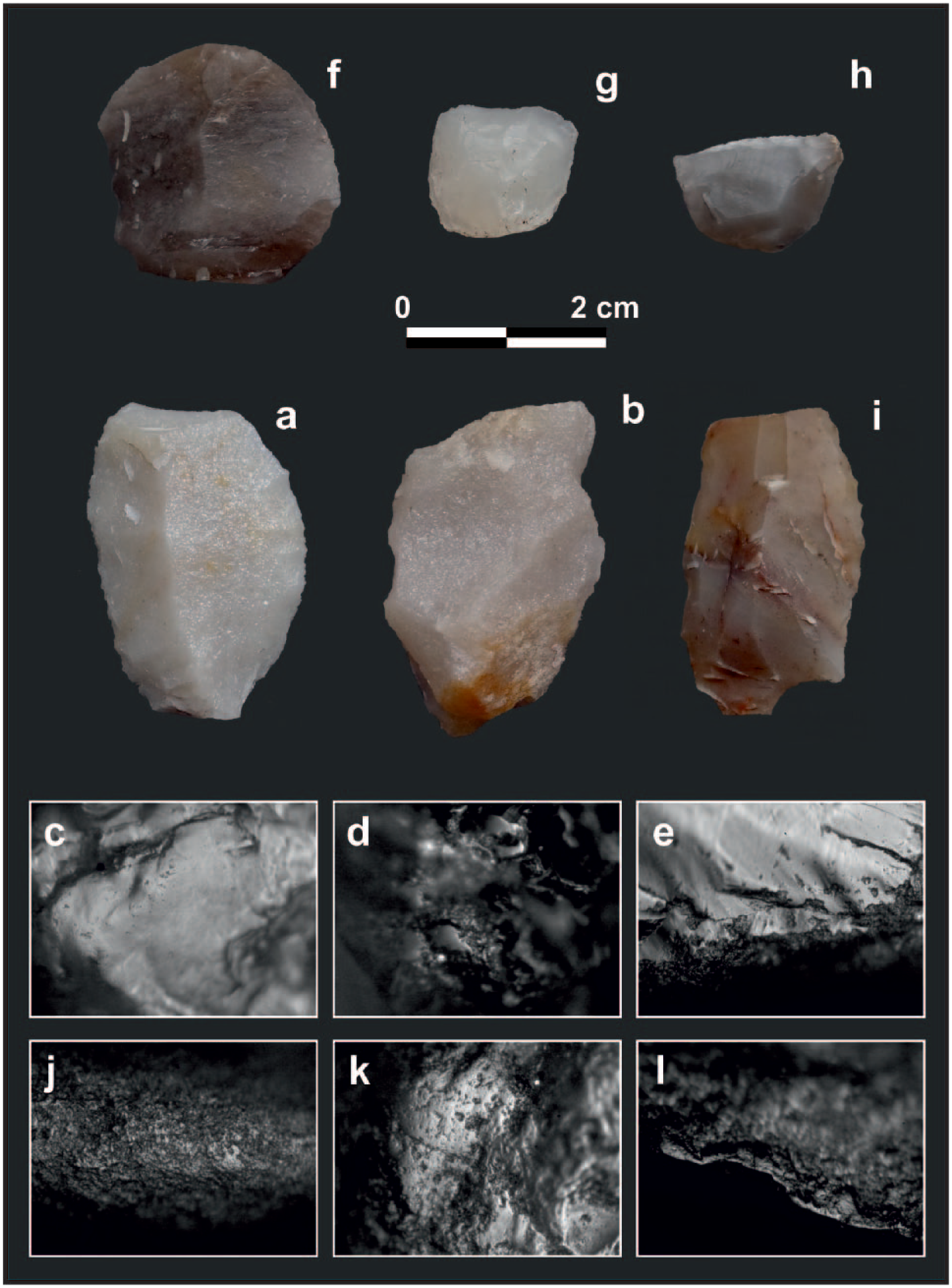
Diversity of lithic tools and materials processed in Laguna Cabeza de Buey 2 site. (a) Side-scraper in orthoquartzite from the U-IV; (b) multipurpose tool in orthoquartzite from the U-IV; (c) wood sawing with orthoquartzite tool from the U-IV; (d) bone scraping with orthoquartzite tool from the U-IV; (e) hide scraping with orthoquartzite tool from the U-III (f, g, h) end-scrapers in chert from the U-II/I; (i) knife in chert from the U-II/I; (j) wood scraping with chert tool from the U-II/I; (k) wood scraping with orthoquartzite tool from the U-II/I; and (l) cutting non-woody vegetables with chert flake from the U-II/I. Microscope images with ×200 magnifications.
In U-III, it is recognized the second event of human occupation in the site in the late middle Holocene (ca. 4700 cal. yr BP; Figure 3). Among the fauna remains that present human exploitation, we identified guanaco (MNI = 3), Pampas deer (MNI = 1), and the same three species of armadillos that were found in the U-IV. The U-III has the greatest variety and quantity of anatomical units of guanaco. The most abundant anatomical regions of this species are the skull, the hind limb, and the forelimb (100% each). The vertebrae and the autopodium have low values, while pelvis and ribs show the least representation (Figure 5). Cut marks recorded on guanaco bones allow the inference of filleting and disarticulation activities (57.8% and 26.3%, respectively) and, to a lesser extent, skinning and scraping tasks. Also, intentional fractures were determined on long bone diaphysis.
The lithic assemblage in U-III is represented by 233 items greater than 5 mm (Table 5), being the tool density of 0.65 items per m2. The most abundant stone is orthoquartzite (75.5%), followed by chert (20.2%), granitoid (2.1%), silicified dolomite (0.9%), siliceous chert (0.9%), and sandstone (0.4%). The 99% of the lithic raw material come from the Tandilia Hills but also there is one stone from the western Pampas (400/500 km from the site). Among the tools, we identified three end-scrapers, two unifacial retouched flake tool, one side-scrapers, one burin, two bolas stone (one also functioned as a hammer/anvil), one small fragment of projectile point, and five fragments of unidentified tools. Microwear analysis shows that four of the orthoquartzite tools worked wood (cutting and scraping), hide (scraping, Figure 6e), hard material (scraping possibly bone), and undetermined.
In U-II, we recognized the third event of human occupation in the late Holocene (after 2600 yr BP; Figure 3). Although no radiocarbon dates were obtained from this unit, due to the poor preservation of guanaco bones collagen, the presence of small potsherds supports this chronological assignation (see Politis et al., 2001). Fauna remains with human bone modifications are guanaco (MNI = 1), Pampas deer (MNI = 1), the Greater rhea (Rhea Americana, MNI = 1), and two species of armadillos (Chaetophractus sp. and Zaedyus pichiy).
The abundance of anatomical units of guanaco shows that the cranial skeleton has the highest value (100%), followed by the hind limb and forelimb (50% each). The lowest values were obtained for vertebrae, pelvis, ribs, and autopodium (Figure 5). In this unit, it is interpreted an important variation in processing patterns, since the activities that predominate are associated with disarticulation and skinning (40% each), followed by filleting (20%). The anthropic fractures were determined mainly in the phalanges and long bone diaphysis.
Bones of modern fauna introduced during the Hispanic conquest (Equus caballus and Bos taurus) were recorded in U-II as well as in a rodent burrow in U-III, but these elements are part of a migration from the U-I due to postdepositional processes, where bones of these species are more abundant. Also, both species show clear human modification supporting the idea of a post-Hispanic occupation.
The lithic assemblage of U-II/I is represented by 464 items greater than 5 mm (Table 5), being the tool density of 0.96 items per m2. The most abundant stone is orthoquartzite (61.9%), followed by chert (33.6%), siliceous chert (1.9%), silicified dolomite (0.9%), granitoid (0.9%), sandstone (0.4%), undetermined (0.2%), and silicified siltstone (0.2%). Most of the lithic raw material comes from Tandilia Hills (99%), but there are elements from the western Pampas and the southern Pampas (Ventania Range, 190 km from the site). Among the tools, we identified five end-scrapers (Figure 6f–h), three unifacial retouched flake tools, one notched, one side-scrapers, one knife (Figure 6i), one burin, one multipurpose, one raclette, one hammer, and seven fragments of unidentified tools. Microwear analysis shows that five of the orthoquartzite tools worked hide (cutting and scraping), wood (scraping, Figure 6j and k), and hard material (sawing and scraping), while five of the chert tools only scraped hide soft tissue, wood, and undetermined material. Four natural edges in orthoquartzite worked scraping hide and soft material, sawing and scraping wood, and hard material with indeterminate movement. The only natural edge in chert worked cutting non-woody vegetables (Figure 6l).
Stratigraphy-sedimentology of the CB1-CB3-CB6 lake cores
Fourteen units were distinguished in the longest core (CB3) of the Cabeza de Buey lake (Figure 4). One conspicuous tephra bed appears in the three cores, at about 90–110 cm from the top (units U7 and U8), which helps to correlate the cores. Above the tephra, the uppermost units U6 to U1 were correlated with the units recognized in CB1 and CB6 cores (Figure 4).
The lowermost 40 cm of CB3 core is a massive, dark to very dark grayish brown, silty fine sand, with some millimeter muddy beds (units U13 and U14). Organic carbon varies between 3.6–5.6% (Supplementary Material, Figure 1, available online). After a sharp contact, there is a fining upward, silty succession with dark gray colors (units U12–U9), first massive and with increasing organic carbon (up to 11.2%) and, then, showing heterolithic lamination.
The tephra bed (5–10 cm in thickness) is a light gray, sandy silt rich in glass shards and pumices (Figure 4), forming a mainly massive unit below (unit U8) and showing a fine lamination to the top (unit U7), where it is mixed with epiclastic sediments. Above the tephra bed, the upper half part of CB3 core and all CB1 and CB6 cores are dominated by dark gray to black silts, with variable proportions of sand and clay (Figure 4). The beds are mainly massive or show a diffuse lamination. Organic carbon is variable, with a section rich in organic carbon (7.8–18.4%) between ~72 and 90 cm, related to the black silts of unit U5. Above there are lower values (mean 6.3%) with an increasing upward tendency, reaching up to 11.4% to 23.0% of organic carbon in the uppermost 16 cm, associated to the black mud of unit U1 (Figure 4; Supplementary Material, Figure 1, available online).
There were different depositional conditions in the Cabeza de Buey lake. The granulometry of U14 and U13 suggests aeolian sedimentation, which is subaerial condition, maybe related to the supralittoral area of an incipient shallow lake. Similar aeolian environments are developed at present in some sectors around the lake. The millimeter muddy beds interlayered with this sand indicate accumulation by suspension in temporary small ponds. After that, the core shows a change to dark silty units that reveal an increase of lake level that creates submerged sedimentation conditions. The U12 is interpreted as accumulation in a lacustrine marginal area while the U11 to U9 represent pelagic sedimentation in the lacustrine inner area (Guerra et al., 2015).
The thick tephra bed of the three cores attests a significant accumulation of ash traveling from the Sollipulli volcano in the Andean region (~1000 km south-west of the lake; Fontijn et al., 2016), preferentially trapped by the water body as the tephra is not recorded in the surrounding sedimentary sections. The dark silty units covering the tephra bed (units U6–U1) indicate the Cabeza de Buey lake continues with a high lake level-stand, dominated by pelagic sedimentation at core location (Guerra et al., 2015).
Pollen and NPP
Pollen and NPP are presented in Figure 7 that shows the percentages and concentration (pollen grains, spores, resistant structures, algal colonies, or coenobiums per cm3 of sediment) of the main relevant taxa. Three pollen and NPP assemblages zones (PAZ) can be distinguished on the pollen and NPP diagram. They comprise changes in aquatic plant community and in the terrestrial vegetation of the Cabeza de Buey lake area, since middle Holocene to present.

Pollen and non-pollen palynomorph percentages and concentrations from Cabeza de Buey lake. Zones were defined using CONISS.
PAZ1 (ca. 5300–1500 cal. yr BP)
This zone is characterized by the high abundance (percentage and concentration) of the green alga Botryococcus, accompanied by Pediastrum, Desmidiaceae, and Zygnematales. The pollen spectra present very low sums, minor than 300 grains, so concentration values should be taken into account, which are extremely low. These values began to increase to the top of the zone.
PAZ2 (1500–ca. 100 cal. yr BP)
In this zone pollen and NPP have representative sums. It is characterized by Poaceae and Cyperaceae accompanied by Asteroideae and Chenopodiace, which increases values from the middle of the zone to the top. Ruppia presents its highest values at the beginning of the zone, and at the top, Myriophyllum and Potamogeton increase. Among the NPP, Botryococcus declines to the top and it is replaced by Pediastrum, with an increasing trend.
PAZ3 (ca. 100 cal. yr BP to the present)
This zone is characterized by Cyperaceae, Poaceae, Chenopodiaceae, and Asteroideae. The submerged Myriophyllum and Potamogeton present their maximum values, also Exotic trees (Eucalyptus, Casuarina, Cupressus, and Pinaceae). Among the NPP, Pediastrum dominates the spectra, accompanied by Other Chlorophyta (Scenedesmus, Tetraedron, Tetrastrum), Desmidiaceae, Zygnematales, and Gloeotrichia.
Discussion
During the late Pleistocene and early Holocene, previous to the first human occupation registered in the site, the here obtained geological and chronological data indicate sedimentation of aeolian sand, likely related to the parabolic dunes that characterize the landscape. The OSL date of 12,635 ± 1020 years, from the base of a sterile archeological deposit of U-V of Laguna Cabeza de Buey 2 site, supports that, for that time, sand was wind deposited in the landscape. Possibly, the megafaunal bones found in U-IV and at the base of U-III would be more linked with this period (Pleistocene–Holocene transition) and the association with the first human occupation in the site is perhaps the result of the mixture produced by postdepositional processes.
Regionally, some localities of the aeolian system of central Argentina also show evidence of aeolian sedimentation during the late Pleistocene and early Holocene (Tripaldi and Zárate, 2016). At the nearby Suriano section, an OSL age of 10,700 ± 1700 years in aeolian sand (Kruck et al., 2011) also indicates aeolian sedimentation during this time. At the Andean piedmont (~34°S; 68°W), there were dune migration and sedimentation of aeolian sand sheet in the Médanos de los Naranjos paleo–dune field between ~21,000–19,000 years and at ~14,000 years (Tripaldi et al., 2011). The San Luis paleo–dune field experienced a phase of aeolian aggradation between ~22,000 and 17,000 years and, then, during most of the Holocene (~12,000 and 1000 years; Tripaldi and Forman, 2016). More recently, Mehl et al. (2018) presented evidence of aeolian sedimentation, accompanied by fluvio-eolian processes at local ephemeral streams, between ~28,000 and 9000 years in the aeolian unit of La Pampa Province.
A study of past plant communities denoted an herbaceous psammophytic steppe exited in the central Pampas prior to 10,500 cal. yr BP, which indicated a subhumid-dry climate and annual precipitation 100 mm lower than present (Prieto, 1996). Subsequently, pollen data showed a change toward a vegetation representing a higher availability of water (Prieto, 1996).
Environmental conditions and human occupations during the middle and early late Holocene
During the middle Holocene, two events of human occupations were identified at Laguna Cabeza de Buey 2 archeological site. The first event (ca. 7640 cal. yr BP) presents a small amount of lithic materials and a low diversity of tools. The techno-morphological analysis suggests that the final stages of the tool production (retouching and resharpening of the tool edges) were carried out at the site. The tools were used for working hard material, such as scraping bone and sawing/scraping wood. Likewise, the archeofaunal remain points out a low diversity and number of species. These evidences suggest a locus of specific activity associated with the hunting and primary processing of artiodactyls (guanaco and Pampas deer) and small preys (armadillos). The tasks included the initial consumption of long bones marrow and the processing of carcasses to facilitate the transport of high-value anatomical units to residential camps.
During the second human event, in the late middle Holocene and the early late Holocene (ca. 4700–2600 cal. yr BP), the archeological record of U-III shows a slight increase in the density of lithic materials and the number of types of tools. The microwear analysis indicates, like at U-IV, that the lithic tools worked mainly hard materials, such as scraping/sawing wood and possibly bone, as well as the scraping of hide. From the techno-morphological point of view, a predominance of the last stages of lithic reduction is also recorded. The faunal remain evidences the hunting and processing of artiodactyls, predominately the camelid Lama guanicoe, although the Pampas deer and armadillos were also exploited.
Both human occupations in the middle Holocene and during the early late Holocene were developed under a climate framework drier than the present subhumid to humid one. This inference is based on several lines of evidences. First, U-IV and U-III in Laguna Cabeza de Buey 2 archeological site and units S3 and S2 in Suriano section suggest aeolian sedimentation in a sand sheet environment with a moderate vegetation cover (Figure 8a).

Scheme of environmental evolution since middle Holocene in Cabeza de Buey lake area. (a) Middle Holocene; (b) late Holocene.
The archeofaunal record shows the presence of species that are restricted to arid/semiarid environments. The association of Tolypeutes matacus and Zaedyus pichiy, which have been recognized in other Pampean sites during the middle Holocene, was interpreted based on their ecological requirements as indicators of arid and warm conditions within the framework of the middle-Holocene Thermal Maximum (Soibelzon, 2017; Soibelzon and León, 2017). The taxonomic diversity of rodents indicates an environmental probably characterized by grasses patches (e.g. Calomys sp., Akodon azarae, and Necromys sp.), shrubs (e.g. Reithrodon auritus), and sandy soils (e.g. Ctenomys sp.). The record of Holochilus brasiliensis (U-IV and U-III) and Pseudoryzomys simplex (U-III) at the Laguna Cabeza de Buey 2 site suggests the presence of flooded terrains close to the site (Scheifler and Messineo, 2016). This last inference is also supported by the presence of gastropods in the U-IV (e.g. Miradiscops brasiliensis, Succinea meridionalis, and Biomphalaria peregrina) which indicates some availability of water (Steffan, personal communication, 2017).
Sediment lake record reveals aeolian sedimentation associated to temporary small lake before ca. 5800 cal. yr BP (units U13 and U14 of CB3 core). After that, a lacustrine marginal area (U12) was established that then evolved to subaqueous conditions dominated by sedimentation by suspension (U11–U9). The presence of a shallow and brackish water body nearby the Laguna Cabeza de Buey 2 archeological site after 5300 cal. yr BP is evidenced by a poorly aquatic plant community (Cyperaceae, other emergent macrophytes and Myriophyllum) and the abundance of chlorophytes Botryococcus. This assemblage is consistent with a landscape of vegetated dunes and flooded interdunes (Figure 8a), where the regional plant community (grassland) is indicated by the scarce presence of terrestrial pollen (Poaceae, Asteraceae Asteroideae, and Chenopodiaceae).
In spite of the few climatic records in central Pampas for the middle Holocene, some studies suggest dry or arid general conditions in agreement with inferences from Cabeza de Buey lake area. Mancini et al. (2005) based on plant formation distribution proposed a displacement of the arid–semiarid region toward central Pampas during the middle Holocene (since 8000 to 4000 cal. yr BP). Aeolian sedimentation was dominant during most of the Holocene (~12,000–1000 years) in the San Luis paleo–dune field (Tripaldi and Forman, 2016). In the northwestern margin of the aeolian system of central Argentina (Médanos Grandes paleo–dune field), OSL dating of sand beds indicated dune migration at ~4000–4300 years (Tripaldi and Forman, 2007). Near General Acha city (La Pampa Province), aeolian deposits, related to the littoral sand flat of an ephemeral lake, yielded OSL ages of ~5800 and 4300 years (Mehl et al., 2018).
Under these environmental conditions (regional aeolian sedimentation in partially vegetated dunes and brackish water bodies in the lowlands under drier conditions than the present), the site would have been characterized by ephemeral human occupation. This period is represented by mobile hunter-gatherer populations that visited this sector of the landscape when these small shallow and temporary water bodies occurred, possibly through daily foraging trips and/or a logistic mobility (Binford, 1980) to exploit faunal resources. The low diversity of hunted taxa, mainly the camelid, and the last stages of lithic reductions could be associated to these ephemeral human occupations or with specific purpose sites. In summary, Cabeza de Buey lake area would have functioned as a locus for the hunting and processing of animals by a small group of hunters.
Environmental conditions and human occupations during the late Holocene
In the late late Holocene (U-II/I at the Laguna Cabeza de Buey 2 site), the hunter-gatherer occupation record presents a depositional rate of lithic assemblage higher than before. Stones from diverse origins (Tandilia, Ventania, and western Pampas) suggest social interactions with human groups of other areas of the Pampean plain. The presence of pottery fragments, the great lithic tool diversity (side-scrapers, end-scrapers, multipurpose, and burins, among others), the knapping techniques (flakes, bifacial, and bipolar reductions), and the activities developed with these tools evidence a greater number of tasks carried out on the site than during the previous periods. The microwear analysis shows the processing of animal resources, such as the scraping and sawing of dry skins/hide with additives, the sawing and scraping of hard (possibly bone) and soft materials (meat, tissue and/or tendon). These evidences also highlight the work of plant elements, such as scraping and sawing of wood and cutting of non-woody vegetables.
The faunal exploitation shows that artiodactyls (guanaco and Pampas deer) were the predominant species in the subsistence, but also others taxa were hunted such as the Greater rhea and two species of armadillos. The pattern of skeletal remains of artiodactyls at Laguna Cabeza de Buey 2 site is similar to that recorded in other sites of central Pampas with middle-Holocene occupations (Scheifler, 2018). However, the predominance of disarticulation and skinning activities suggest secondary processing of carcasses. Likewise, the increase of the fractures on the phalanges and the presence of the pottery technology suggest changes in the intensity of the processing of the artiodactyls to obtain possibly a greater amount of fatty nutrients (Stoessel, 2014).
Several lines of evidence suggest environmental conditions during the late late Holocene occupations were similar to the present ones. During this period, the littoral area of Cabeza de Buey lake was dominated by a stabilized surface (evidence of weak pedogenesis associated to low rates of aeolian sedimentation at U-II and U-I of Laguna Cabeza de Buey 2 site), while aeolian sedimentation continued at other areas of the study landscape (unit S2 of Suriano section). The presence of rodent species of tropical lineage (e.g. Dasypus hybridus and Cavia aparea) in U-II and the disappearance of species that are currently restricted to arid/semiarid environments (e.g. Tolypeutes matacus and Zaedyus pichiy) denote that climatic conditions during the late late Holocene would have evolved toward the subhumid–humid temperate conditions that prevails today (Scheifler and Messineo, 2016).
The establishment of a permanent water body is indicated by pollen and NPP record at ca. 2000 cal. yr BP. The macrophyte community, characterized by emergent, submerged, and floated-living and a well-developed phytoplankton community of Pediastrum, Botryococcus, and other Chlorophyta (Scenedesmus, Tetraedron, Desmidiaceae, and Zygnematales) indicate a well-established freshwater lake at 1500 cal. yr BP (Figure 8b). Moreover, the replacement in chlorophyte community of Botryococcus by Pediastrum and the disappearance of Ruppia denote a high input of freshwater into the lake ca. 1000 cal. yr BP. These more stable and humid conditions are also indicated by the regional vegetation represented by abundant values (percentage and concentration) of Poaceae, Chenopodiaceae, and Asteraceae Asteroideae.
A quantitative estimation of precipitation based on a pollen sequence indicates subhumid–humid conditions during the last 3000 cal. yr BP for the central Pampas (Tonello and Prieto, 2010). Inferences based on paleoclimate records away from study area presents some disagreement about climate conditions at the Pampean plain during the late Holocene. These discrepancies could be associated to differences in spatial and temporal resolution of the records or different sensitivity of the proxies. However, some authors agreed with a climatic regionalization since about middle Holocene, mainly regarding to the precipitation gradient in the Pampean plain (Mancini et al., 2005; Tonello and Prieto, 2010).
Under these new environmental conditions (a more stable landscape with vegetated aeolian landforms and a nearby permanent freshwater lake), the human occupations would have changed noticeably as the lake area became a place where people settled with a high degree of recurrence. The greater quantity and diversity of lithic tools, the wide range of activities carried out with them, the faunal remains, the presence of pottery, and rocks with diverse origins suggest that Laguna Cabeza de Buey 2 site represented a locus of multiple activities where hunter-gatherer groups manufactured lithic artifacts, processed and consumed animals (mainly artiodactyls), worked vegetal, wood and skin/hide, and cooked food in ceramic containers, among others.
Post-Hispanic human occupations
In the top of the of Laguna Cabeza de Buey 2 site, a human occupation related to post-Hispanic times is identified. Horses and cows show clear evidences of human modification supporting their exploitation (Scheifler and Messineo, 2016). These modern fauna remains, introduced during the Hispanic conquest (16th century), are associated with fragments of metal and a venetians vitreous bead. The use of European glass beads was documented in missionary, military, and aboriginal settlements for the 16th–19th centuries (Tapia and Pineau, 2011). At this point, it is important to notice the historical importance of the Cabeza de Buey lake area. Several chronicles, dated at the early 18th century, mention the excellent quality of water, some periods of drought, the absence of trees, and the meeting between indigenous and military groups in the Cabeza de Buey lake area (Martínez, 1967 and references therein). This references indicate that the lake was one of the essential stopping points in the commercial route that joined Buenos Aires city with central and western Pampas where there are significant salt deposits (Salinas Grandes). It was also a strategic point in the military excursions related to the conquest of indigenous territories (Martínez, 1967).
Conclusion
This work constitutes the first research that integrated original archeological, paleoecological, and geomorphological information for an aeolian landscape of central Pampas of Argentina, southern South America. The different paleoenvironmental conditions interpreted for the middle Holocene–early late Holocene and late late Holocene promoted changes in the activities developed by the human groups in each occupation events, the different exploitation of faunal remains, the diversity of technological practices, the presence of new technology, and the strategies of mobility, settlement and use of space.
During the middle and early late Holocene, under drier environmental conditions than in the present (regional aeolian sedimentation in partially vegetated dunes and brackish water bodies in the lowlands), the human occupations in Cabeza de Buey was ephemeral with mobile hunter-gatherer populations visiting this shallow water body to hunt artiodactyls (guanaco and Pampas deer), manufacture lithic tools, and work hard material with them. Contrary, under subhumid to humid environmental conditions (dunes more fixed with grassland vegetation and the establishment of a permanent body of water), at the late late Holocene, the human occupation show a higher degree of recurrence that is based on the greater quantity and diversity of tools, the wide range of substances processed, the change in the intensity of processing artiodactyls, and the presence of pottery.
To sum up, this first multidisciplinary study contributed to relate human occupations to the dynamics of dune-lake environments in central Pampas during the middle late Holocene while further research in other sectors are required to make inferences on a wider spatial and temporal scales.
Supplemental Material
Supplementary_Material,_Figure_1 – Supplemental material for Human occupation strategies and related environmental-climate during the middle and late Holocene in central Pampas of Argentina
Supplemental material, Supplementary_Material,_Figure_1 for Human occupation strategies and related environmental-climate during the middle and late Holocene in central Pampas of Argentina by Pablo G Messineo, Marcela S Tonello, Silvina Stutz, Alfonsina Tripaldi, Nahuel Scheifler, Nélida Pal, Guillermina Sánchez Vuichard and Diego Navarro in The Holocene
Supplemental Material
Supplementary_Material,_Figure_2 – Supplemental material for Human occupation strategies and related environmental-climate during the middle and late Holocene in central Pampas of Argentina
Supplemental material, Supplementary_Material,_Figure_2 for Human occupation strategies and related environmental-climate during the middle and late Holocene in central Pampas of Argentina by Pablo G Messineo, Marcela S Tonello, Silvina Stutz, Alfonsina Tripaldi, Nahuel Scheifler, Nélida Pal, Guillermina Sánchez Vuichard and Diego Navarro in The Holocene
Supplemental Material
Supplementary_Material,_Table_A – Supplemental material for Human occupation strategies and related environmental-climate during the middle and late Holocene in central Pampas of Argentina
Supplemental material, Supplementary_Material,_Table_A for Human occupation strategies and related environmental-climate during the middle and late Holocene in central Pampas of Argentina by Pablo G Messineo, Marcela S Tonello, Silvina Stutz, Alfonsina Tripaldi, Nahuel Scheifler, Nélida Pal, Guillermina Sánchez Vuichard and Diego Navarro in The Holocene
Supplemental Material
Supplementary_Material,_Table_B – Supplemental material for Human occupation strategies and related environmental-climate during the middle and late Holocene in central Pampas of Argentina
Supplemental material, Supplementary_Material,_Table_B for Human occupation strategies and related environmental-climate during the middle and late Holocene in central Pampas of Argentina by Pablo G Messineo, Marcela S Tonello, Silvina Stutz, Alfonsina Tripaldi, Nahuel Scheifler, Nélida Pal, Guillermina Sánchez Vuichard and Diego Navarro in The Holocene
Footnotes
Acknowledgements
The investigations are being carried out with the support of San Carlos de Bolívar city, through the collaboration of Mr. Santos Vega. We would like to thank Dr. Karen Fontijn (Department of Earth Sciences, University of Oxford, UK) who determined the chemical composition of the core tephra and to Dr. Pamela Steffan (INCUAPA–CONICET, Facultad de Ciencias Sociales, UNICEN, Argentina) who identified the gastropod species from the site. Diana Sierra collaborated in the geological survey and in the analysis of sediment samples (Facultad de Ciencias Exactas y Naturales, UBA, Argentina). We also want to thank to the students of archeology of the Facultad de Ciencias Sociales (UNICEN) who participated during the field seasons. This work is part of our ongoing research carried out in the INCUAPA–CONICET (Universidad Nacional del Centro de la Provincia de Buenos Aires), the IIMyC–CONICET (Universidad Nacional de Mar del Plata), and the IGEBA–CONICET (Universidad de Buenos Aires). However, the content and interpretations are full responsibility of the authors.
Funding
This work was supported by the National Geographic Society (Grant No. 9773-15), the Consejo Nacional de Investigaciones Científicas y Técnicas (PIP No. 11220130100414CO), the Agencia Nacional de Promoción Científica y Tecnológica (PICT 2014-2070), and the Universidad de Buenos Aires (UBACyT 20620130100002BA).
References
Supplementary Material
Please find the following supplemental material available below.
For Open Access articles published under a Creative Commons License, all supplemental material carries the same license as the article it is associated with.
For non-Open Access articles published, all supplemental material carries a non-exclusive license, and permission requests for re-use of supplemental material or any part of supplemental material shall be sent directly to the copyright owner as specified in the copyright notice associated with the article.