
Abstract
The mid-Holocene behaviour of five glaciers in the British Columbia Coast Mountains was reconstructed from radiocarbon ages and stratigraphic analysis. Subfossil wood evidence at Canoe, Fyles, Jacobsen, Tchaikazan and Icemaker glaciers suggests these glaciers were expanding into standing forests prior to 6630, 4900 and 4200 cal. yr BP. Stratigraphically constrained woody detritus at Fyles Glacier records the progradational history of a Gilbert-type delta forming in response to glacial expansion between 7020 and 5470 cal. yr BP. This research provides the first evidence for mid-Holocene glacial expansion in the central and northern British Columbia Coast Mountains. Proxy records describing mid-Holocene climates in the British Columbia Coast Mountains indicate a trend towards slightly cooler and possibly wetter conditions than present. Glacial expansion occurring between 7500 and 4000 cal. yr BP has regional correlatives, suggesting coherent broad-scale climate forcing mechanisms influenced glacial mass balance at this time.
Introduction
Most glaciers in the British Columbia Coast Mountains reached their maximum Holocene extent between c.
The emerging chronology of Holocene glaciation in coastal British Columbia appears constrained to six broadly recognized periods of climate change at 9000–8000, 6000–5000, 4200–3800, 3500–2500, 1600–1300, and 600–150 cal. yr BP (dates are presented as calibrated years before present (cal. yr BP)) (Mayewski et al., 2004). There is limited evidence for short-lived glacier advance at 8200 cal. yr BP (Menounos et al., 2004), equivocal evidence for three intervals of mid-Holocene glacier expansion at c. 6000 cal. yr BP (Ryder and Thompson, 1986), 4900 cal. yr BP (Menounos et al., 2009) and 4200 cal. yr BP (Menounos et al., 2008), widespread glacier expansion at 3500 cal. yr BP (Ryder and Thomson, 1986), 2300 cal. yr BP (Koehler and Smith, 2011) and 1600 cal. yr BP (Reyes et al., 2006), and the onset of LIA glacier advances in the 11th century (Allen and Smith, 2007; Koch et al., 2007a).
Despite the considerable progress made in understanding the regional character of these Holocene advances (Menounos et al., 2009), very little is known of the character of glacier expansion during the mid Holocene from 7500 to 4000 cal. yr BP (Menounos et al., 2008; Ryder and Thomson, 1986). There is limited detrital and in situ evidence suggesting that glaciers may have repeatedly advanced into living forests in the southern Coast Mountains over this time (Koch et al., 2007b; Koehler and Smith, 2011; Mathews, 1951; Osborn et al., 2007). Clastic units within lacustrine deposits in the same region may record corresponding episodes of mid-Holocene glacier expansion (Cashman et al., 2002; Filippelli et al., 2006; Menounos et al., 2008; Osborn et al., 2007; Souch, 1994). Reconstructed Holocene summer temperature using chironomid (non-biting midges) analysis, indicates rapid cooling beginning between approximately 7500–4000 14C yr BP in coastal British Columbia (Palmer et al., 2002).
The intent of this paper is to present new evidence extending and detailing the regional record of mid-Holocene glacial expansion in the Coast Mountains. These findings are summarized in the context of existing mid-Holocene records in the western Canadian Cordillera and are used to discuss the likely climate forcing mechanisms responsible for glacier expansion at this time.
Evidence for mid- Holocene glacier advance
Alpine glaciers act as sensitive indicators of climatic variability (Denton and Karlen, 1973). Over decadal intervals, the terminal and lateral positions of alpine glaciers fluctuate in response to mass balance adjustments to changing temperature and precipitation regimes (Klok and Oerlemans, 2003). In the Coast Mountains persistent positive mass balance episodes during the Holocene resulted in periods of glacial expansion that frequently saw glaciers overrunning living trees to bury them within and beneath glacigenic deposits (Koch et al., 2007b; Osborn et al., 2007). Radiocarbon or tree-ring dating of these glacially killed trees entombed in growth position, either within valley-side or valley-floor deposits, provides direct evidence for when a glacier advanced over a specific site (Allen and Smith, 2007; Koehler and Smith, 2011). Studies of lateral moraine stratigraphy, where buried detrital wood mats separate discrete till units, commonly yield a continuous chronology of Holocene glacier expansion (Jackson et al., 2008; Reyes and Clague, 2004).
Most proxy records describing mid-Holocene climates in the Coast Mountains indicate a trend towards slightly cooler and possibly wetter conditions than present (Hebda, 1995; Mathewes, 1985). Based upon dendroglaciological evidence at a limited number of sites, previous researchers concluded that these changing environmental conditions prompted glacier expansion at 6950–5620 cal. yr BP (Ryder and Thomson, 1986) and 4400–4000 cal. yr BP (Menounos et al., 2009). Supported by radiocarbon-dated remains and clastic-rich sediment facies within lake cores, these advances appear associated with global climatic events documenting extended intervals of cooler summers and wetter winters (Mayewski et al., 2004; Zhang and Hebda, 2005). While there is limited evidence for corresponding advances in the Canadian Rocky Mountains at 7500–5500 cal. yr BP (Clague et al., 2009; Luckman et al., 1993), 4900 cal. yr BP (Menounos et al., 2009) and 4200 cal. yr BP (Gardner and Jones, 1985; Luckman, 1995; Wood and Smith, 2004), ongoing research efforts in the Coast Mountains confirm these were regional events (Menounos et al., 2009).
Paleoclimate reconstructions indicate that cooler climate conditions commenced during the early portion of the mid Holocene in the Northern Hemisphere (Mayewski et al., 2004; Wanner et al., 2008). Outside of British Columbia in the Northern Hemisphere, glacial advances dating to 7500–4000 cal. yr BP have been documented at various locations including Tibet (Seong et al., 2009), Sweden (Karlen, 1988), and Alaska (Barclay et al., 2009).
Study sites
The Coast Mountains are a northwest-trending mountain belt extending from southwestern British Columbia to the St Elias Mountains of southwestern Yukon and Alaska (Figure 1). Recent terminus retreat at five Coast Mountain glaciers located in the Pacific and Boundary Ranges has exposed the glacially killed remains of trees buried during mid-Holocene glacier advances. In the Frank Mackie Icefield area adjacent to southern Alaska, the remains of trees recovered between till units provide the first confirmation of mid-Holocene glacier expansion in the northern Coast Mountains.
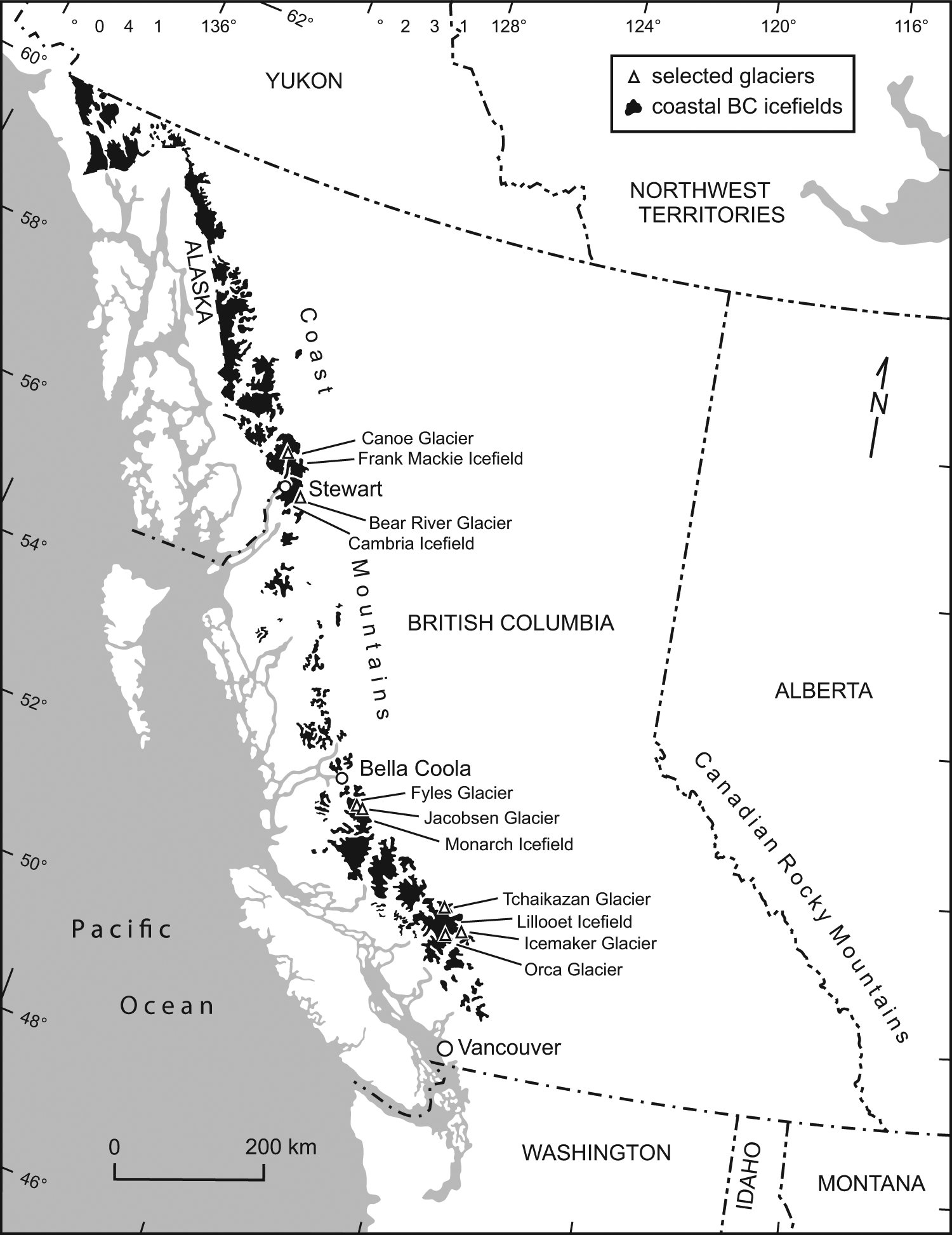
Map showing the location of study sites at Canoe, Fyles, Jacobsen, Tchaikazan and Icemaker glaciers.
In the Monarch Icefield area near Bella Coola (Figure 1), in situ tree stumps and detrital wood provide the first record of mid-Holocene glacier advances in the central Coast Mountains region. In the Lillooet Icefield area (Figure 1), detrital wood washed from beneath one glacier and sheared tree stumps in growth position at another site confirm the widespread extent of mid-Holocene advances in the southern Coast Mountains.
The Coast Mountain region is underlain primarily by granitic rocks and geologic structures of the Coast Plutonic Complex marking the transition to the Intermontane Volcanic Belt (Baer, 1973). Tertiary and Quaternary glaciations shaped the land surface forming the major valley drainage systems (Tribe, 2002). While climates in the vicinity of the Frank Mackie and Monarch icefields are strongly influenced by maritime weather systems originating in the North Pacific Ocean, rainshadow effects and continental climates also have an impact on glaciers in the Lillooet Icefield area. Dominant subalpine tree species in the region include Engelmann spruce (Picea engelmannii), mountain hemlock (Tsuga mertensiana), subalpine fir (Abies lasiocarpa), and whitebark pine (Pinus albicaulis). Disturbed and recently deglaciated surfaces host densely growing sitka alder (Alnus viridis ssp. sinuate) (Flora of North America Editorial Committee, 1997; Meidinger and Pojar, 1991).
Methods
Reconnaissance investigations were carried out in the summers of 2002 (Fyles and Tchaikazan glaciers), 2005 (Icemaker Glacier), 2006 (Canoe Glacier) and 2010 (Jacobsen Glacier). Each glacier site was systematically surveyed to locate in situ and detrital subfossil wood. Disk samples cut with a chainsaw were air-dried and polished using progressively finer grades of sandpaper to define the annual tree-ring boundaries. Tree-ring widths were measured to 0.01 mm on high resolution digital images from perimeter to pith using a WinDENDRO measuring system (v. 2006) (Guay et al., 1992). Multiple radii were measured to reduce the possibility of missing rings and to replicate data (Stokes and Smiley, 1968).
Where the provenance suggested samples were likely of similar age, an attempt was made to construct floating chronologies using the visual cross-dating program CDendro v.4.1.1 (Larsson, 2003). Following this, the chronologies were quality-checked with COFECHA v. 6.06 (Grissino-Mayer, 2001), using 50 year dated segments lagged successively by 25 years with the critical level of correlation set at 0.32 (99% one-tailed confidence interval; Holmes, 1983).
Perimeter wood from selected samples was submitted to Beta Analytic Inc. for conventional radiocarbon dating. The 14C ages were calibrated using INTCAL 09 (Reimer et al., 2009) and the 2 sigma ranges reported as cal. yr BP. Calendar ranges were assigned to include the entire area under the probability distribution and rounded to the nearest 10 cal. yr BP. These ranges were used to anchor the 14C samples within the locally constructed floating chronology.
Results
Canoe Glacier
Canoe Glacier is an eastward-flowing glacier located in the Boundary Ranges 50 km north of Stewart (53°23′N, 130°03′W; Figure 1). The glacier extends 7 km down-valley from the Frank Mackie Icefield to terminate at Tippy Lake. Like nearby Knipple and Frank Mackie glaciers, Canoe Glacier is assumed to have extended across and dammed the Bowser River during the late Holocene (Clague and Mathews, 1992). Up-valley deposits indicate that Frank Mackie Glacier expanded prior to 3000 cal. yr BP, between 2950–2540 cal. yr BP and 1640–1390 cal. yr BP, and during the 10th and 11th centuries to create glacially dammed Tide Lake (Clague and Mathews, 1992).
Three wood mats separated by till were located along the north-facing lateral moraine at Canoe Glacier c. 1.3 km up-valley from the 2006 icefront. While the uppermost wood mat was inaccessible, perimeter wood from a log (UVTRL-06CAN01; Figure 2) lodged c. 5 m below within a wood-rich laterally continuous organic mat dates to 3360±50 14C yr BP (3720–3470 cal. yr BP; Table 1). A third wood mat located 3.5 m below contained an assemblage of broken boles visible over a 25 m long contact (Figure 2). Perimeter wood from a large bole cross-section (UVTRL-06CAN03) dates to 4570±50 14C yr BP (5450–5050 cal. yr BP; Table 1).
Canoe Glacier study site. (a) Sample UVTRL-06CAN01; (b) Location of three wood mats at Canoe Glacier. Woody mats are highlighted with white broken lines. The uppermost mat was inaccessible. Sample UVTRL-06CAN01 was located in the middle mat dating to 3720–3470 cal. yr BP and the lower woody mat dates to 5450–5050 cal. yr BP (UVTRL-06CAN03).
Summary of mid–Holocene (7500–4000 cal. yr BP) radiocarbon dates obtained at sites in the Coast Mountains, Canadian Rocky Mountains, and Interior Ranges, British Columbia. Locations are arranged from north to south.

Radiocarbon Laboratory: Beta: Beta Analytical Inc. Miami FL; GSC: Geological Survey of Canada; UCIAMS: University of California; WAT: University of Waterloo; Y: Yale University.
Sample ID provided for samples from the University of Victoria Tree-Ring Laboratory.
Radiocarbon dates converted to calendar ages BP (2σ) using CALIB 6.0 (Reimer et al., 2009). Ages were rounded to the nearest 10 cal. yr BP.
This radiocarbon evidence suggests Canoe Glacier was expanding downvalley and overwhelming mature valley-side forests at 5450–5050 and 3720–3470 cal. yr BP. While neither advance is recorded in adjacent Bowser Valley glacier histories (Clague and Mathews, 1992; Clague and Mathewes, 1996), the latter event is recorded by detrital wood in till dating to 4220–3850 cal. yr BP at Bear River Glacier in the nearby Cambria Icefield (Jackson et al., 2008).
Fyles Glacier
Fyles Glacier (52°06′N, 126°13′W; Figure 1) spills from the Monarch Icefield where it historically formed a glacial dam that led to the creation of Ape Lake (Gilbert and Desloges, 1987). Sometime after

(a) The study site was located approximately 1 km from the 2002 Fyles Glacier ice front. (b) Incised exposure of delta deposits at Fyles Glacier shows five distinct stratigraphic units. The exposure is approximately 10 m thick for scale.
Field investigations in the summer of 2002 within a 200 m horizontal section revealed laterally contiguous stratigraphic units (Figure 3). Observations of unit thicknesses and sediment character were used to identify the continuity of different facies. Where organic horizons or oxidized sediments units were identified, their position and lateral extent was determined. Samples of in situ and detrital woody debris were collected, dried and submitted for radiocarbon dating.
Unit 1
Unit 1 consists of a minimum 3 m thick rhythmic sequence of horizontally bedded silt and fine sand lenses that coarsen upwards from river level to Unit 2 (Figure 3). Scattered, 2–5 cm diameter dropstones appear in the uppermost 25 cm of the unit. Ripples and climbing ripples distinguish the contact with Unit 2.
Two wood samples were retrieved from Unit 1 at the mid-point of the exposure. A sample (FG02-19) located 1 m below the contact with Unit Two contained 141 annual rings and yielded a perimeter age of 5570±70 14C yr BP (6500–6220 cal. yr BP; Table 1). A branch fragment with eight rings (FG02-06) found 0.5 m below the contact dates to 5640±80 14C yr BP (6630–6290 cal. yr BP; Table 1).
Unit 2
Unit 2 contains a 3 m thick sequence of steeply dipping (25°) interbedded coarse sand and gravel layers (Figure 3). Both fining- and coarsening-upwards sequences were noted within the unit. A branch fragment (FG02-07) was collected 1 m above the contact within Unit 1 close to the westernmost extent of the exposure. Containing 13 annual rings, the branch dates to 5980±80 14C yr BP (7020–6640 cal. yr BP; Table 1).
Unit 3
Overlying Unit 2 is a 2 m thick horizontally bedded unit whose lower extent is distinguished by interbedded coarse sand and gravel lenses (Figure 3). The upper extent of Unit 3 contains sloping beds (<10°) of fine sand (max. 40 cm thick) interrupted by a thick (>10 cm) planar organic horizon containing the partially decomposed remains of small tree branches. A branch fragment (FG02-18) from the organic horizon dates to 5240±70 14C yr BP (6270–5800 cal. yr BP; Table 1).
Unit 4
Unit 4 decreases in thickness (1–2 m) from west to east, suggesting that the proximal extent of the unit is truncated at the surface. At its thickest point the unit contains two horizontally bedded gravel facies with occasional coarse sand lenses separated by laterally contiguous inclusions of fine sand and organics. A log (FG02-07) found protruding from the uppermost gravel layer contained 62 annual rings and dates to 4860±60 14C yr BP (5730–5470 cal. yr BP; Table 1; Figure 3).
Unit 5
Unit 5 is capped by a 1 m thick deposit of matrix-supported sediment ranging in size from fine sands to large boulders (Figure 3). Annual recessional moraines on the upper surface of Unit 5 suggest it represents an ice-contact deposit.
Interpretation
The lowermost units exposed at Fyles Glacier following catastrophic release of floodwater from Ape Lake in 1984, represent topset, foreset and bottomset beds typical of a Gilbert-type delta (Bates, 1953). The delta architecture indicates progradation towards the present-day position of Ape Lake. The delta deposits are overlain by braided stream deposits and till.
The radiocarbon dates assigned to detrital wood fragments sampled within the delta deposit indicate Fyles Glacier expanded to blockade upper Noeick River prior to 7020–6640 cal. yr BP (Table 1). Progradation into Ape Lake was underway at this time burying a branch (FG02-07) within the foreset beds close to the western extent of the delta complex. The detrital character of the branch and the other woody debris recovered from the section suggest snow avalanches, or possibly debris flows, were depositing wood debris at the glacier terminus and within Ape Lake.
Delta progradation persisted for an extended period, as wood samples collected from the contemporaneous bottomset unit (c. 70 m up-valley) date to 6630–6290 and 6500–6220 cal. yr BP (Table 1). Dropstones in Unit 1 indicate that either Ape or Fyles glacier was calving into Ape Lake at this time. The progradation of foreset over bottomset beds is demarcated by climbing ripples, indicating that deposition occurred at a mid to distal delta position (Clemmensen and Houmark-Nielsen, 1981). A branch fragment contained within the overlying topset bed (Unit 3) confirms delta formation continued at least until 6270–5800 cal. yr BP (Table 1).
The delta is overlain by 1 to 2 m of braided stream deposits (Unit 4) that date to 5730–5470 cal. yr BP (Table 1). Indicative of a subaerial depositional environment, the unit may signal that Ape Lake had drained by this time or that Fyles Glacier had advanced closer to the site. The surface of Unit 4 is truncated and overlain by a more recently deposited and modified till.
The delta complex at Fyles Glacier describes a mid-Holocene advance that dammed the Noeick River allowing Ape Lake to fill from 7020 to 5800 cal. yr BP. While subsequent Holocene-age fluctuations of Fyles Glacier may have allowed Ape Lake to drain and fill several times, there is no evidence of these events within the delta complex. However, Gilbert and Desloges (1987) show distinct acoustic reflectors in distal Ape Lake deposits that probably record episodes of sediment influx associated with past undated catastrophic drainages.
Jacobsen Glacier
Jacobsen Glacier is a large northeastward-flowing outlet glacier of the Monarch Icefield (Figure 1). Prominent lateral moraines of late-Holocene and LIA origin flank the glacier (Desloges and Ryder, 1990). Since
In July 2010 field surveys were completed on a portion of the Jacobsen Glacier north lateral moraine marking the divide between the Talchako and Noeick river valleys, approximately 7 km east of Ape Lake (Figure 4). An in situ stump rooted in a palaeosol, ice pressed logs, and multiple detrital wood samples were located at four sites close to ice level within the proximal moraine face.

Jacobsen Glacier study site. (a) Dendroglaciological study sites at Jacobsen Glacier. (b) At Site A (1451 m a.s.l.), the location of four detrital bole fragments including radiocarbon dated sample JAC0504 (6550–6300 cal. yr BP) is shown. (c) Sample JAC0301 (6680–6410 cal. yr BP), one of two ice-pressed logs at Site B and radiocarbon dated (1420 m a.s.l.).
Four detrital bole fragments oriented downvalley were excavated from till at Site A (1451 m a.s.l.; Figure 4). Cross-sectional disks were cut and perimeter wood from one sample (JAC0504) containing 63 rings had a radiocarbon age of 5630±60 14C yr BP (6550–6300 cal. yr BP; Table 1).
The remains of two additional trees were located 200 m downslope from Site A adjacent to the glacier margin at Site B (1420 m a.s.l.; Figure 4). Pressed into the proximal face of a projecting piece of bedrock and encased by till, perimeter wood containing 52 rings from JAC0301 dates to 5760±60 14C yr BP (6680–6410 cal. yr BP; Table 1).
At Site C 100 m down-valley the remains of a second rooted stump surrounded by detrital branches and small bole fragments were found in till at 1458 m a.s.l. (Figure 5). At Site D 130 m down-valley, a small glacially sheared stump rooted in a steeply sloping palaeosol was located beneath a till veneer close to where a small stream was eroding through the proximal moraine face (1420 m a.s.l., Figure 5). Additional woody detritus was found in till several metres downslope.

Jacobsen Glacier dendroglaciological findings. (a) Site C (1458 m a.s.l.); (b) glacially sheared stump located (JAC0101) at Site C; (c) Site D (1420 m a.s.l.); (d) sample JAC0602 located at Site D.
In total, 23 samples of detrital subalpine fir (Abies lasiocarpa) wood and stump remnants were collected at the four sites. Nine of the samples crossdate to form a 177 year-long floating tree-ring chronology (r= 0.403).
Interpretation
Expansion of Jacobsen Glacier at 6680–6300 cal. yr BP resulted in the burial of a mature subalpine forest and palaeosol located beneath a deposit of till. The crossdated remains of sheared rooted stumps and detrital boles within 0–20 m vertically of the 2010 ice surface suggest Jacobsen Glacier is morphologically similar in size and shape today as it was during this mid-Holocene event.
Tchaikazan Glacier
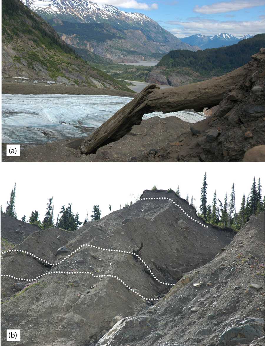
Tchaikazan Glacier is a large 7 km long valley glacier located at the northern limit of the Lillooet Icefield (51°02′N, 123°48′W; Figure 6). The glacier drains into Taseko Lake via Tchaikazan River and has retreated 2 km upvalley at rates ranging from 0.9 to 31.0 m/yr (1951–2002; Lixvar, 1983; Ricker, 1976) from nested LIA terminal moraines dating to

(a) Icemaker Glacier. The black circle indicates the location of the rooted glacially sheared stump IM05-01 dated to 6640–6320 cal. yr BP. (b) View of north-facing Tchaikazan Glacier.
In July 2002, during moraine surveys in the upper headwaters of the Tchaikazan Valley, quantities of large detrital bole fragments were observed washing from beneath the snout of Tchaikazan Glacier at 1900 m a.s.l. Appearing freshly broken, this woody detritus rafted downstream to be deposited on the surface of a broad outwash plain.
After drying, cross-sections of samples stranded on the outwash surface were examined and identified as the remnants of mature whitebark pine trees. Perimeter wood from four samples dates to: TG02-7 = 5380±70 14C yr BP (6300–5990 cal. yr BP); TG02-24 = 4660±70 14C yr BP (5590–5080 cal. yr BP); TG02-10 = 4440±70 14C yr BP (5290–4870 cal. yr BP); and, TG02-17 = 3730±60 14C yr BP (4280–3900 cal. yr BP) (Table 1).
Interpretation
The glacially broken detrital wood flushed from unknown locations beneath Tchaikazan Glacier appears associated with three distinct mid-Holocene advances. The oldest sample (TG02-7) is presumed related to a mid-Holocene advance of Tchaikazan Glacier in c. 6000 cal. yr BP, with the three other radiocarbon-dated samples likely providing evidence for glacier advances identified regionally at 4900 cal. yr BP (Menounos et al., 2009) and at 4200 cal. yr BP (Menounos et al., 2008).
Icemaker Glacier
Icemaker Glacier is small cirque glacier located on the north face of Icemaker Mountain (50°46′N, 123°21′W; Figure 6). Meltwater from the snout of the glacier at 1770 m a.s.l. flows into the headwaters of the Lillooet Icefield. Within the last century Icemaker Glacier has retreated 1.5 km from nested terminal moraines constructed in c.
During a reconnaissance survey in July 2005, two glacially sheared stumps in growth position were located 200 m from the ice margin at 1793 m a.s.l. (Figure 6). Partially buried by till and rooted in a well-developed palaeosol, the stumps remained beneath the glacier until sometime after
Discussion
The discovery and dating of mid-Holocene age dendroglaciological samples from several new Coast Mountain locations serve to emphasize that glaciers expanded and retreated at least three times between 7500 and 4000 cal. yr BP. Evidence from Fyles, Jacobsen and Icemaker glaciers suggests regional expansion began prior to narrowly defined intervals of 6630–6290, 6680–6410 and 6640–6320 cal. yr BP, respectively. Continued delta progradation into proglacial Ape Lake at 6270–5800 cal. yr BP, along with the discovery of detrital wood killed by an advance of Tchaikazan Glacier at 6300–5990 cal. yr BP, suggests glaciers in the region remained in advanced positions until sometime before 5470 cal. yr BP. Braided stream deposits truncating delta topset beds at Ape Lake date to 5730–5470 cal. yr BP and may suggest Fyles Glacier was retreating at this time.
A subsequent interval of mid-Holocene glacier expansion between 5590 and 4870 cal. yr BP is discerned from detrital evidence discovered at Tchaikazan Glacier and from bole fragments recovered from the lateral moraine at Canoe Glacier. Only at Tchaikazan Glacier was evidence located corroborating glacier expansion also occurred between 4280 and 3900 cal. yr BP.
Regional comparisons
A growing body of evidence from the southern Canadian Cordillera describes a complex history of mid-Holocene glaciation (Figure 7). An early mid-Holocene episode of glacier expansion (the ‘Garibaldi Phase’ of Ryder and Thompson, 1986) is restricted to the interval from 6950 to 5620 cal. yr BP. Previous researchers describe concurrent glacier advances in Garibaldi Provincial Park at 7300–5800 cal. yr BP (Koch et al., 2007b; Mathews, 1951; Osborn et al., 2007), as well as in the Canadian Rocky Mountains at 7460–6800 cal. yr BP (Luckman, 2007) and 5610–5320 cal. yr BP (Menounos et al., 2009). The in situ and detrital dendroglaciological evidence collected during surveys at Fyles, Icemaker, Jacobsen and Tchaikazan glaciers dating to 6630–5900 cal. yr BP constrains the timing of this advance and lends considerable support for interpretations of it as regional in extent (Koch et al., 2007b; Menounos et al., 2009).

Summary of calibrated radiocarbon ages pertaining to glacier advances during the 7500–4000 cal. yr BP mid-Holocene interval in the Coast Mountains. 2 sigma calibrated ranges are presented. The stars indicate samples that directly date ice margin expansion. Glacier sites are arranged north to south.
The discovery of a second interval of mid-Holocene glacier expansion 5590–5050 cal. yr BP at Tchaikazan and Canoe glaciers has only a few regional correlatives (Menounos et al., 2009). Combined with the discovery of detrital wood in till in Garibaldi Provincial Park (5040–4590 cal. yr BP; Osborn et al., 2007), a glacially killed in situ stump in the Canadian Rockies dating to 5610–5330 cal. yr BP (Luckman, 2007), and detrital and in situ wood in the Cariboo Mountains at 5580–5460 cal. yr BP (Menounos et al., 2009), these dendroglaciological findings substantiate lake sediment records of a regional glacier advance prior to c. 4900 cal. yr BP (Menounos et al., 2008).
A third mid-Holocene glacier advance at 4400–4000 cal. yr BP has previously been documented at several sites in the southern Coast Mountains (Koch et al., 2007b; Koehler and Smith, 2011; Menounos et al., 2008; Osborn et al., 2007) and in the Canadian Rocky Mountains at 4820–3830 cal. yr BP (Gardner and Jones, 1985; Luckman, 1995; Wood and Smith, 2004). Detrital wood washing from the snout of Tchaikazan Glacier dating to 4280–3900 cal. yr BP may also record this event and expands the regional extent of this advance.
This emerging record of mid-Holocene glacier expansion suggests three positive mass balance episodes at 6680–5990, 5590–5050 and 4400–4000 cal. yr BP. Cooler summer temperatures and increased winter precipitation at these times likely led to these events (Hebda, 1995). Huesser et al. (1985) argue that this change in climate conditions was inaugurated as the subtropical Pacific anticyclones that dominated the early Holocene to produce warm and dry climates in the Pacific Northeast, were replaced by cooler and wetter conditions as the influence of the Aleutian low pressure centre gradually intensified. The discovery of glacially killed trees in Garibaldi Provincial Park suggests this climatic shift was inaugurated by 7400 cal. yr BP in the southern Coast Mountains when glaciers began expanding into established forests (Koch et al., 2007b; Mathews, 1951; Osborn et al., 2007). Evidence of continued glacier expansion at Icemaker, Fyles and Jacobsen glaciers dating to 6630–6300 cal. yr BP confirms the persistence of this shift and the regional nature of positive glacier mass balance states at the beginning of the mid Holocene in the southern and central Coast Mountains.
Conclusions
Mid-Holocene glacier expansion was documented at five glaciers in the Coast Mountains. Radiocarbon dates assigned to in situ and detrital subfossil wood located in glacial forefields, delta deposits and lateral moraines constrains the timing of three glacier advances between 7500 and 4000 cal. yr BP. The findings support and improve upon existing chronologies describing mid-Holocene glacier activity in the British Columbia Coast Mountains, firmly establishing the regional nature of advances that began prior to 6630, 4900 and 4200 cal. yr BP. Documentation of these discrete glacier advances indicates that mid-Holocene climates were likely more varied than reported (Hebda, 1995) and were likely influenced by climate changes related to intensification of the Aleutian low pressure center in the region (Huesser et al., 1985). Future investigations of Holocene glaciation in the central and northern Coast Mountains and in the Canadian Rocky Mountains will benefit from this more complete characterization of mid-Holocene glacier fluctuations.
Footnotes
Acknowledgements
The authors thank Jessica Craig, Laurel George, Scott Jackson, Alexis Johnson, Lynn Koehler, Dave Lewis, Mel Page, Kelly Penrose, Kara Pitman, and Colette Starheim for their field assistance. The authors wish to thank our two anonymous reviewers for their helpful comments which helped to improve the manuscript.
Funding
Support for this research was provided by Natural Science and Engineering Research Council of Canada (NSERC) awards to Smith and Desloges, and a Canadian Foundation for Climate and Atmospheric Science (CFCAS) award to the Western Canadian Cryospheric Network (WC2N).