



Abstract
Franklin Glacier is an 18-km-long valley glacier that originates in a broad icefield below the west face of Mt. Waddington in the central British Columbia Coast Mountains, Canada. Radiocarbon-dated wood samples from the proximal faces of lateral moraines flanking Franklin Glacier show that the glacier expanded at least nine times since 13,000 cal. yr BP. A probable Younger Dryas advance of Franklin Glacier at 12,910–12,690 cal. yr BP followed the late glacial retreat and down wasting of the Cordilleran Ice Sheet from ca. 16,000 to 12,900 cal. yr BP. During the succeeding early Holocene warm period, Franklin Glacier appears to have retreated significantly, leaving no record of glacial expansion until the mid-Holocene when it repeatedly advanced at 6360–6280, 5470–5280 and 4770–4580 cal. yr BP. Down wasting of the glacier surface after ca. 4770–4580 cal. yr BP was followed by intervals of expansion at 4260–4080, 3210–3020 and 2620–2380 cal. yr BP. Following ice expansion at ca. 2620–2380 cal. yr BP into trees over 224 years in age, there is no record of the glacier activity until 1570–1480 cal. yr BP when Franklin Glacier thickened and advanced into young subalpine fir trees. During the ‘Little Ice Age’, advances at 800–680, 610–560 and 570–510 cal. yr BP preceded a mid-19th to early 20th century advance that saw Franklin Glacier attain its maximum Holocene extent. The dendroglaciological record at Franklin Glacier is among the most comprehensive recovered from the British Columbia Coast Mountains and showcases the complexity of mid- to late Holocene glacier expansion in the region.
Introduction
The late Pleistocene and Holocene behaviour of glaciers in the British Columbia Coast Mountains reflects mass balance responses to changing regional and global climates (Menounos et al., 2009). Most glaciers in the region attained their maximum Holocene extent at the end of the ‘Little Ice Age’ (Harvey and Smith, 2013; Larocque and Smith, 2003), after which they experienced significant volumetric losses (Koch et al., 2007, 2014; VanLooy and Forster, 2008; Tennant et al., 2012). The resultant down wasting and terminus retreat has revealed the remains of glacially overridden and buried forests below till and outwash deposits, enabling description of the spatial and temporal character of latest Pleistocene and Holocene glacier activity (e.g. Harvey et al., 2012; Hoffman and Smith, 2013; Koch et al., 2007).
Previous glacial history investigations in the Mt. Waddington area of the central Coast Mountains (Figure 1a) show that glaciers repeatedly advanced into mature standing forests throughout the Holocene (Coulthard et al., 2013; Craig and Smith, 2013; Larocque and Smith, 2003; Menounos et al., 2013; Ryder and Thomson, 1986). Based on present-day mass balance–climate relationships (Larocque and Smith, 2005b; Wood et al., 2011), these Holocene advances likely occurred in response to persistent intervals of cool summers and wet winters similar to those that resulted in glacial advances during the ‘Little Ice Age’ (Larocque and Smith, 2005a; Pitman and Smith, 2012). Ameliorating climate following each advance would have caused glaciers to down waste and retreat, allowing forests to repeatedly colonize the deglaciated valley bottoms and lateral moraine slopes.
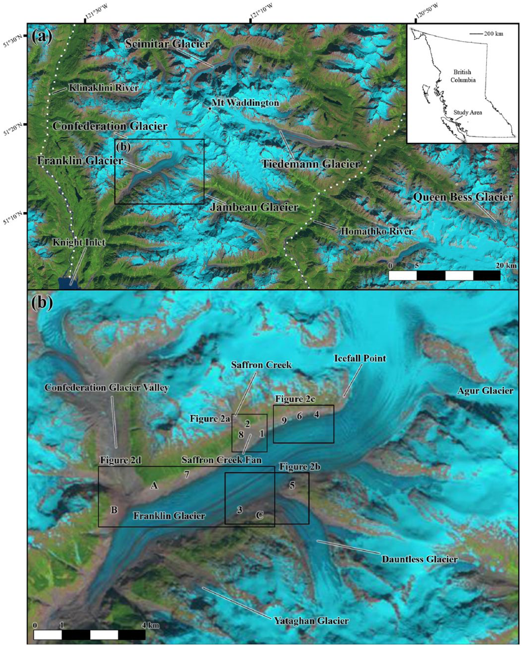
(a) Mt. Waddington area highlighting location of previously studied glaciers in the region and geographic features and (b) Franklin Glacier study area. Numbers indicate sampling sites from this study and letters indicate sample sites from Rutherford et al. (1984), Ryder and Thomson (1986) and Coulthard et al. (2013).
Despite a growing appreciation of the Holocene behaviour of glaciers in the Mt. Waddington area, complementary studies undertaken elsewhere in the Coast Mountains indicate that our understanding of this activity remains incomplete (e.g. Menounos et al., 2009). In this paper, we characterize the latest Pleistocene and Holocene behaviour of Franklin Glacier as revealed by radiocarbon and tree-ring analyses of subfossil wood remains collected in the summers of 2012 and 2013. On the basis of this evidence, we describe the behaviour of glaciers in the Mt. Waddington area from 13,000 cal. yr BP to present.
Study area
Geographic setting
Franklin Glacier is an 18-km-long valley glacier that originates in a broad icefield at 2150 m a.s.l. below the west face of Mt. Waddington (4019 m a.s.l.) on the windward side of the Pacific Ranges (51°16′N, 125°23′W; Figure 1a and b). Encompassing an area of approximately 175 km2 (Bolch et al., 2010), Franklin Glacier originates from the confluence of smaller tributary glaciers before flowing down valley to its present terminus at 650 m a.s.l., approximately 15 km from Knight Inlet (Figure 1a). The regional climate of the Mt. Waddington area is moderated by close proximity to the Pacific Ocean, with a mean annual temperature of 3.6°C and mean annual precipitation of 1870 mm/yr from 1981 to 2010 (ClimateBC v. 5.00 in Wang et al., 2012). Above 1000 m a.s.l., vegetated mountainsides are forested by mature subalpine fir (Abies lasiocarpa) and mountain hemlock (Tsuga mertensiana) to the local treeline at 1500–1600 m a.s.l.
Research background
In 1927, a party of mountaineers was the first group to traverse the length of Franklin Glacier during their attempt to summit Mt. Waddington (Munday, 1926–1927). Over the next two decades, a succession of expeditions followed the same route, leaving behind a rich descriptive and photographic record providing insight into the response of Franklin Glacier to climate changes in the first half of the 20th century (Munday, 1926–1927, 1930, 1931a, 1931b, 1933, 1934–1935, 1939).
By 1927, Franklin Glacier had retreated almost 2 km up from terminal moraines deposited during a ‘recent’ advance (Munday, 1926–1927). Munday (1939) reports that Franklin Glacier deposited these ‘moraines against a mature forest containing trees that must be several centuries old’, noting that ‘the recent advance exceeded any previous ones that have occurred for several centuries’ (pp. 2–3). Munday (1931b) also noted that the ‘[…] ice-front remained nearly stationary [at this point] for some time’ with ‘a number of short retreats, followed by progressively rapid shrinkage. Between June, 1927, and July, 1931, this amounted to approximately 900 feet [275 m] […] along the whole half-mile [800 m] front’ (p. 133).
Since 1931, the glacier terminus has retreated over 4 km up valley (Munday, 1934–1935; VanLooy and Forster, 2008) in response to persistent negative mass balance conditions generated by increased summer temperatures (Larocque and Smith, 2005b). This period of general retreat has been interrupted by short stillstands and brief intervals of expansion during periods of below average temperatures (Munday, 1939; VanLooy and Forster, 2008).
Confederation Glacier flows southwest down a bedrock-confined valley and, until ca. 1960, was confluent with Franklin Glacier (Coulthard et al., 2013). Photographs from 1927 show the surface of Confederation and Franklin glaciers positioned within 50 m of the ‘Little Ice Age’ lateral moraine crest at 1255 m a.s.l. (Munday, 1926–1927). Investigations by Ryder and Thomson (1986) and Coulthard et al. (2013) close to the former Confederation–Franklin glacier confluence describe the early ‘Little Ice Age’ expansion of Franklin Glacier from 800 to 590 cal. yr BP (sites A and B, Figure 1a). At site A, located at 1220 m a.s.l., Ryder and Thomson (1986) reported an age of 835 ± 45 14C yr BP (800–680 cal. yr BP; Table 1) on a mountain hemlock root in till (S-1568). Coulthard et al. (2013) obtained an age of 600 ± 50 14C yr BP (660–530 cal. yr BP; Table 1) on the perimeter rings of a nearby mountain hemlock stump (A01) rooted in a paleosol immediately below a till unit. At site B, located down valley at 1180 m a.s.l. in Franklin Glacier valley, Coulthard et al. (2013) describe a laterally contiguous wood mat (>30 m wide) exposed in the collapsed proximal face of the lateral moraine. Perimeter rings from a large log that fell from the wood mat to the valley floor (G05) yielded an age of 550 ± 50 14C yr BP (570–510 cal. yr BP; Table 1). While investigations in Confederation Glacier valley indicate that Confederation Glacier advanced into standing forests at 5660–5570, 3910–3570, 3720–3480 and 3580–3340 cal. yr BP (Coulthard et al., 2013), there are no reports of contemporaneous Holocene advances at Franklin Glacier.
Summary of Holocene radiocarbon-dated wood and peat from the Mt. Waddington area.

Prefixes: Beta: Beta Analytics, Inc; S: Saskatchewan Research Council; GSC: Geological Survey of Canada; UCIAMS: University of California; TO: Isotrace Laboratory, University of Toronto.
The term ‘in situ’ is used to describe samples entrained in glacial sediments and not spilled or washed to a secondary location. Sample descriptions from other studies are taken directly from their respective text. Inferences on the nature or state of each sample in other studies cannot be made.
All dates were obtained using conventional radiocarbon dating methods.
±2σ calibration using IntCal2013 (Reimer et al., 2013; Stuiver and Reimer, 1993).
Methods
We surveyed the proximal slopes of lateral moraines flanking Franklin Glacier up valley of the Confederation–Franklin glacier confluence for dendroglaciological evidence with a handheld GPS in 2012 and 2013. Exposed paleosols were located, and representative samples of 30 buried subfossil wood remains were sampled with a chainsaw. When possible, we collected bark and perimeter wood to allow for kill-date determination by tree-ring cross-dating or radiocarbon dating (Coulthard and Smith, 2013). Wood samples were wrapped for transport to the University of Victoria Tree-Ring Laboratory where they were allowed to air-dry before being sanded to a fine polish for tree-ring measurement. A high-resolution scanner (1200 dpi) was used to create a digital image of each sample and the annual radial growth rings were measured using WinDendro software (v. 2012b; precision = 0.001 mm; Guay et al., 1992). Bark and anatomical characteristics were used for species identification (Hoadley, 1990).
We developed floating tree-ring chronologies by internally cross-dating and compiling ring-width series from individual logs to produce site-specific series using standardized methodologies and COFECHA chronology quality control software (Fritts, 1976; Grissino-Mayer, 2001). We attempted to cross-date the undated ring-width series to local living and floating tree-ring chronologies developed by Coulthard et al. (2013). Where cross-dating failed, representative perimeter wood samples were radiocarbon dated using conventional methods by Beta Analytic, Inc. to assign a relative kill date. The 14C ages from this and previous studies were calibrated using IntCal13 (Calib v. 7.02; Reimer et al., 2013; Stuiver and Reimer, 1993) with ±2σ error limits, with the calibrated 14C age designated as the minimum kill date (Coulthard and Smith, 2013).
Results
We collected and dated samples along both flanks of Franklin Glacier, from Icefall Point along the south-facing lateral moraine across the Saffron Creek fan to the confluence with Confederation Glacier valley (sites 1, 2, 4, 6, 7, 8 and 9) and from Agur Glacier to Yataghan Glacier along the north-facing lateral moraine (sites 3 and 5; Figure 1a; Table 1).
Site 1
Site 1 is located ca. 20 m above the 2013 ice surface within sediments exposed by stream erosion on the Saffron Creek fan along the northern flank of Franklin Glacier at 1340 m a.s.l. (Figure 2a; Table 1). The remains of two logs (FG13-23 and FG13-24) were found pressed into the organic surface of a buried paleosol located in a gully sidewall ca. 100 m below the ‘Little Ice Age’ maximum ice-level position and adjacent to the proximal face of bedrock outcrop. The paleosol dips down valley and includes a black Oh or Ah horizon (<5 cm) with visible fir needles, a thin (<1 cm) underlying grey-coloured incipient eluviated horizon and a red-brown B horizon (10–15 cm) developed on the surface of a sandy till unit. The logs were found within 2 m of each other below a remnant cap of till (>1.5–2 m thick) mantled by recently deposited alluvial gravels. Both boles were oriented down valley towards the glacier terminus. Bark remained on the underside of the trunks, and anatomical characteristics indicate both were the remains of young subalpine fir trees (ca. 90 and 52 years old; Table 1). There was insufficient evidence to determine whether the trunks were the remains of trees transported by snow avalanches or, alternatively, are the remains of young subalpine forest that once colonized the buried paleosol. Thirty perimeter rings from FG13-23 yielded a 14C age of 10,920 ± 50 (12,910–12,700 cal. yr BP); 28 perimeter rings from FG13-24 yielded a 14C age of 10,880 ± 50 (12,830–12,690 cal. yr BP; Table 1). Attempts to cross-date the samples failed due to the limited number of annual rings.
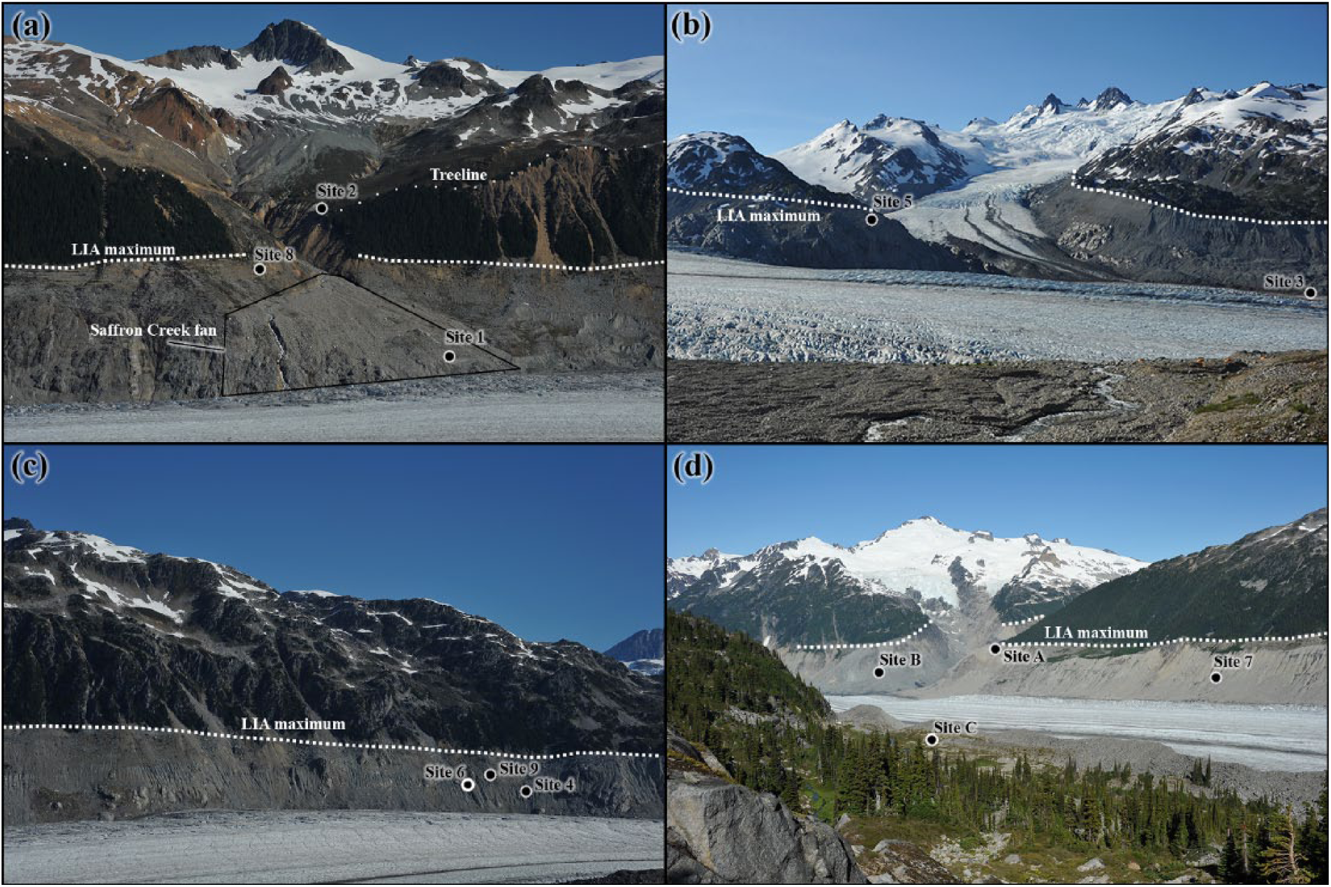
Site photographs showing location of study sites above the summer 2013 ice surface shown in (a) northern flank of Franklin Glacier in vicinity of the Saffron Creek fan. Position of contemporary treeline and ‘Little Ice Age’ trimline highlighted (terminus located left of image), (b) the Dauntless–Franklin glacier confluence showing ‘Little Ice Age’ trimline (terminus located right of image), (c) northern flank of Franklin Glacier down valley from Icefall Point (terminus located left of image), and (d) foreground shows location of drained moraine-dammed lake adjacent to Dauntless–Franklin glacier confluence (terminus located to left of image). Background illustrates northern flank of Franklin Glacier in vicinity of former confluence with Confederation Glacier. Highlighted is position of ‘Little Ice Age’ trimline.
Site 2
Site 2 is located within sediments exposed in the scarp-face of a rotational slump at 1560 m a.s.l., 100 m above the ‘Little Ice Age’ maximum ice-level position (Figures 2a and 3a). The slump exposed a >5-m-thick vertical section of till overlain by 15- to 30-cm-thick unit of weakly bedded silts and fine sands with occasional subangular stones. A modern soil varying in thickness from 0.75 to 1.0 m overtops the sequence. Detrital subalpine fir remains of unknown origin are buried within the bedded colluvial unit (<15 cm above the till section), and a sample with ca. 40 annual rings was collected (FG13-11). Twenty-seven perimeter rings from FG13-11 yielded a 14C age of 8910 ± 40 (10,190–9910 cal. yr BP; Table 1).
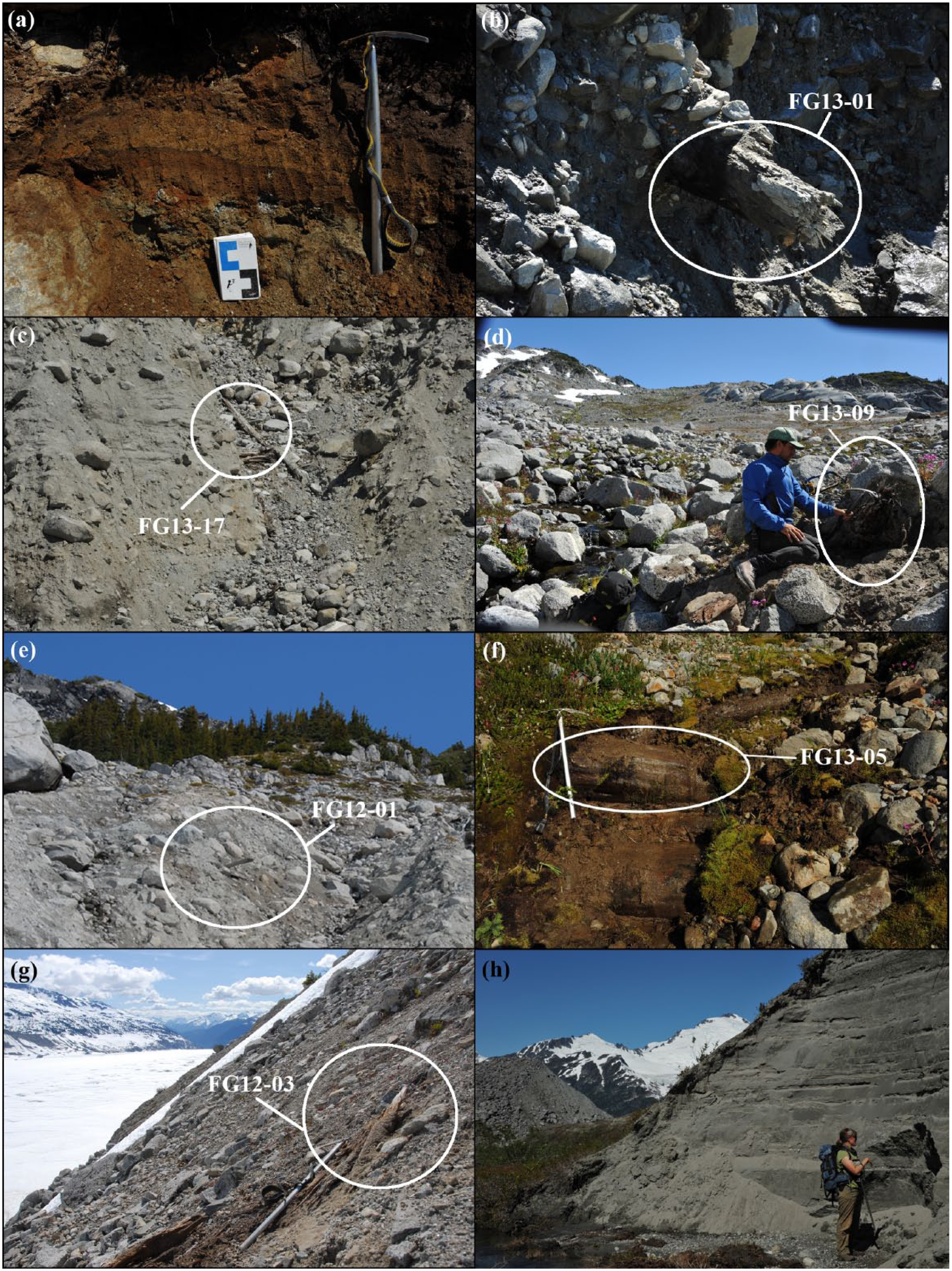
Dendroglaciological sample sites at Franklin Glacier, shown in (a) site 2 illustrating modern soil and position of FG13-10 exposed above modern treeline by recent rotational slump adjacent to Saffron Creek, (b) large trunk exposed by ice-marginal erosion 3 m below the summer 2013 ice surface at site 3, (c) location and gully characteristics at site 4 south of Icefall Point showing where sample FG13-17 was collected from >5 m above the summer 2013 ice surface, (d) rooted and glacially sheared stump (FG13-09) found in growth position at site 5 on southern lateral moraine of Franklin Glacier, (e) vertical gully at site 6 along the proximal face of the northern lateral moraine where FG12-01 was found resting on a weakly expressed paleosol, (f) site 8 illustrating glacially pressed logs in gully. Logs are oriented down valley (right to left) and lie below a mantle of till, (g) in situ glacially sheared stump at site 9 down valley from Icefall Point, and (h) bedded lacustrine sands and silts deposited distal to ‘Little Ice Age’ moraine at site C.
Site 3
Site 3 is 900 m down valley from the confluence of Dauntless and Franklin glaciers at 1220 m a.s.l. (Figures 2b and 3b). Ice-marginal stream erosion exposed >5 m of bedded sands and subangular gravels overlain by >2 m of till. We sampled a large (ca. 1 m diameter) detrital subalpine fir trunk (FG13-01; Table 1) protruding into the abandoned channel at the unit contact. While the origin of the trunk is unknown, its orientation and position immediately below till are suggestive of burial by advancing ice. Perimeter wood yielded an age of 5530 ± 30 14C yr BP (6360–6280 cal. yr BP; Table 1).
Site 4
Site 4 is located at 1450 m a.s.l. downstream of Icefall Point, 40 m below the ‘Little Ice Age’ lateral moraine crest and 60 m above the 2013 ice surface (Figures 2c and 3c). A large gully bisects a laterally continuous wood mat separating two till units; 11 trunk samples were collected (0.25–1 m in diameter, up to 4 m in length) from the wood mat (FG13-12 to FG13-22; Table 1). With the exception of one mountain hemlock trunk (271 rings, FG13-17), the samples came from mature subalpine fir trunks (>70–185 rings). Thirty perimeter rings from FG13-20 and FG13-17 returned ages of 4680 ± 30 14C yr BP (5470–5320 cal. yr BP) and 4600 ± 30 14C yr BP (5330–5280 cal. yr BP; Table 1), respectively. Samples from the wood mat cross-date to form a floating chronology spanning 308 years (Figure 4a).
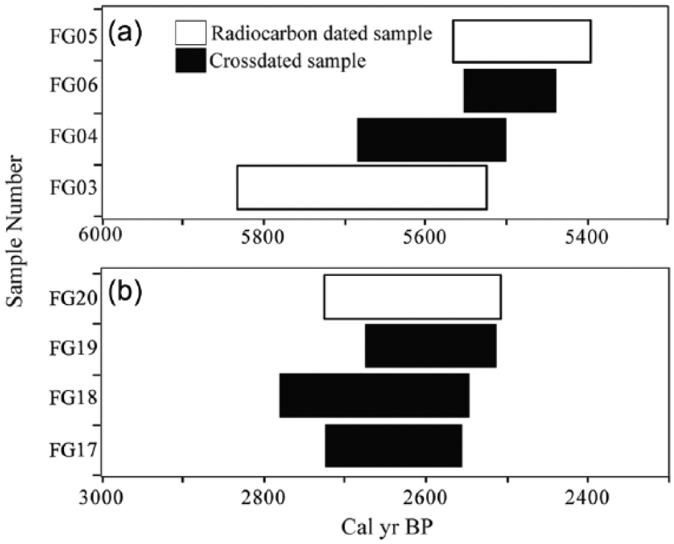
Floating tree-ring chronologies from (a) site 4 (series intercorrelation = 0.425; mean sensitivity = 0.209) and (b) site 7 (series intercorrelation = 0.512; mean sensitivity = 0.226).
Site 5
Site 5 is located between two large bedrock outcrops up valley from the Dauntless–Franklin Glacier confluence at 1410 m a.s.l. (Figures 2b and 3d). Sixteen perimeter rings recovered from a rooted and glacially sheared stump (FG13-09) found in growth position in till provided an age of 4150 ± 30 14C yr BP (4770–4580 cal. yr BP; Table 1).
Site 6
Site 6 is located downstream from Icefall Point at 1480 m a.s.l. (Figures 2c and 3e), ca. 50 m down valley from site 4. An approximately 70-m-long vertical gully bisects the lateral moraine and exposes the remains of numerous small-diameter (<30 cm) trunks on a weakly expressed paleosol at the contact between two till units. Perimeter rings from FG12-01returned an age of 3790 ± 30 14C yr BP (4260–4080 cal. yr BP; Table 1).
Site 7
Site 7 is located 1000 m down valley from the Saffron Creek fan at ca. 1300 m a.s.l. (Figure 2d). A gully cuts through a lateral moraine adjacent to bedrock and has exposed numerous down valley oriented, small-diameter (<15 cm) subalpine fir trunks with bark, pressed into the surface of sloping red-coloured paleosol below till. Perimeter rings from FG13-25 yielded an age of 2960 ± 30 14C yr BP (3020–3210 cal. yr BP; Figure 2b; Table 1).
Site 8
Site 8 is located at 1430 m a.s.l. in a steep gully above the Saffron Creek fan and ca. 10 m below the ‘Little Ice Age’ moraine crest (Figures 2a and 3f). Five subalpine fir logs (0.25–0.5 m in diameter; >161–179 rings) were found partially damming a gully (FG13-03 to 13FG-07). The logs are oriented down valley, lie below a mantle of till and are glacially pressed into an underlying till unit. Twenty-four perimeter rings from FG13-05 yielded an age of 2460 ± 30 14C yr BP (2620–2380 cal. yr BP; Table 1). A floating chronology developed from the five logs spans 264 years (Figure 4b).
Site 9
Site 9 is a bedrock outcrop at 1520 m a.s.l. located downstream of Icefall Point between sites 4 and 6 (Figures 2c and 3g). Several small sheared subalpine fir stumps were found rooted on rock at this site and a perimeter sample from FG12-03 yielded an age of 1630 ± 30 14C yr BP (1570–1480 cal. yr BP; Table 1).
Synthesis and regional correlation
The Pleistocene history of Franklin Glacier prior to the Younger Dryas is presumed to correspond to that of other trunk valley glaciers in this region (Margold et al., 2013). Based upon our interpretation that the pedogenic surface at site 1 developed during an ice-free interval before 12,910–12,690 cal. yr BP, prior to this time, Franklin Glacier would have retreated from Knight Inlet to at least the current ice level at site 1 (<1340 m a.s.l.). While it is possible that the trunks found pressed into paleosol at site 1 represent the remains of eroded deposits transported downslope and buried beneath till by a later Holocene advance of Franklin Glacier, their condition and downslope orientation is consistent with them having been buried by an expanding glacier in 12,910–12,690 cal. yr BP during a well-documented period of regional cooling in coastal British Columbia (Lacourse et al., 2012; Mathewes et al., 1993) that corresponds to the cool, humid phase of the Younger Dryas (Bakke et al., 2009; Broecker et al., 2010; Murton et al., 2010). This period of changing environmental conditions corresponds to a time when glaciers were expanding worldwide (Golledge, 2010; Lohne et al., 2012; MacLeod et al., 2011; Osborn et al., 2012) and is benchmarked by changes in δ18O levels and temperatures in the Greenland GISP2 ice cores and sea surface temperatures in tropical and high-latitude regions (Alley, 2000; Lea et al., 2003; Figure 5).
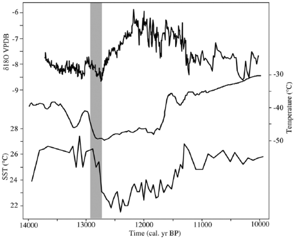
Reconstructed paleoclimate indicators from ca. 14,000 to 10,000 cal. yr BP. The grey bar presents the calibrated radiocarbon age (±2σ) of Younger Dryas age samples (FG13-23 and FG13-24) from Franklin Glacier. The δ18O measured in Vienna Pee Dee Belemnite (VPDB) and temperature record is derived from Greenland GISP2 ice cores (Alley, 2000) and the sea surface temperature record based on fossil forminifera from Cariaco Basin, northern Venezuelan Shelf (Lea et al., 2003).
If Franklin Glacier was expanding down valley in 12,910–12,690 cal. yr BP as posited, it was doing so at a time when trunk valley glaciers located elsewhere in the Coast Mountains had already reached their maximum Younger Dryas positions (Clague, 1985; Friele and Clague, 2002a, 2002b). This differential behaviour is assumed to reflect the overriding influence of regional topography on ice dynamics as the decaying Cordilleran Ice Sheet transitioned to ice lobes in major valleys (Margold et al., 2013; Menounos et al., 2009). In the case of Franklin Glacier, the high-elevation Mt. Waddington massif may have prevented resurgent trunk valley glaciers in the surrounding Homathko and Klinaklini river valleys from contributing to the flow of Franklin Glacier during the Younger Dryas. The local source area and size of the tributary glaciers contributing to Franklin Glacier suggests that it likely experienced exaggerated post-glacial retreat before responding to the Younger Dryas cold event and readvancing down valley (Friele and Clague, 2002a). It remains to be determined whether Franklin Glacier continued to thicken after 12,910–12,690 cal. yr BP to deposit the till observed at site 2. By 10,190–9910 cal. yr BP, however, the terrain above 1560 m a.s.l. was ice-free and colonized by subalpine fir trees at or above the present-day treeline. This colonization occurred at a time when local treelines elsewhere in the Coast Mountains were at least 60 m higher than present as a result of higher-than-present temperatures during the early Holocene (Clague and Mathewes, 1989).
Following the Younger Dryas, during the early Holocene warm period, most Coast Mountain glaciers decayed rapidly, disappearing entirely (Clague and James, 2002) or retreating to terminal positions close to those reached during the ‘Little Ice Age’ (Menounos et al., 2009). For example, by ca. 10,600 cal. yr BP, the Squamish and Mamquam tributary glacier valleys in the southern Coast Mountain region were completely ice-free (Friele and Clague, 2002a).
The first of several documented middle Holocene advances at Franklin Glacier occurred at 6360–6280 cal. yr BP when the glacier buried the remains of large tree trunks below till at site 3. This interval is regionally characterized by lower-than-present July temperatures (Gavin et al., 2011) and long, cool springs (Galloway et al., 2011; Figure 6), conditions that led to glaciers expanding into standing forests elsewhere in the Coast Mountains (Harvey et al., 2012; Koch et al., 2007).
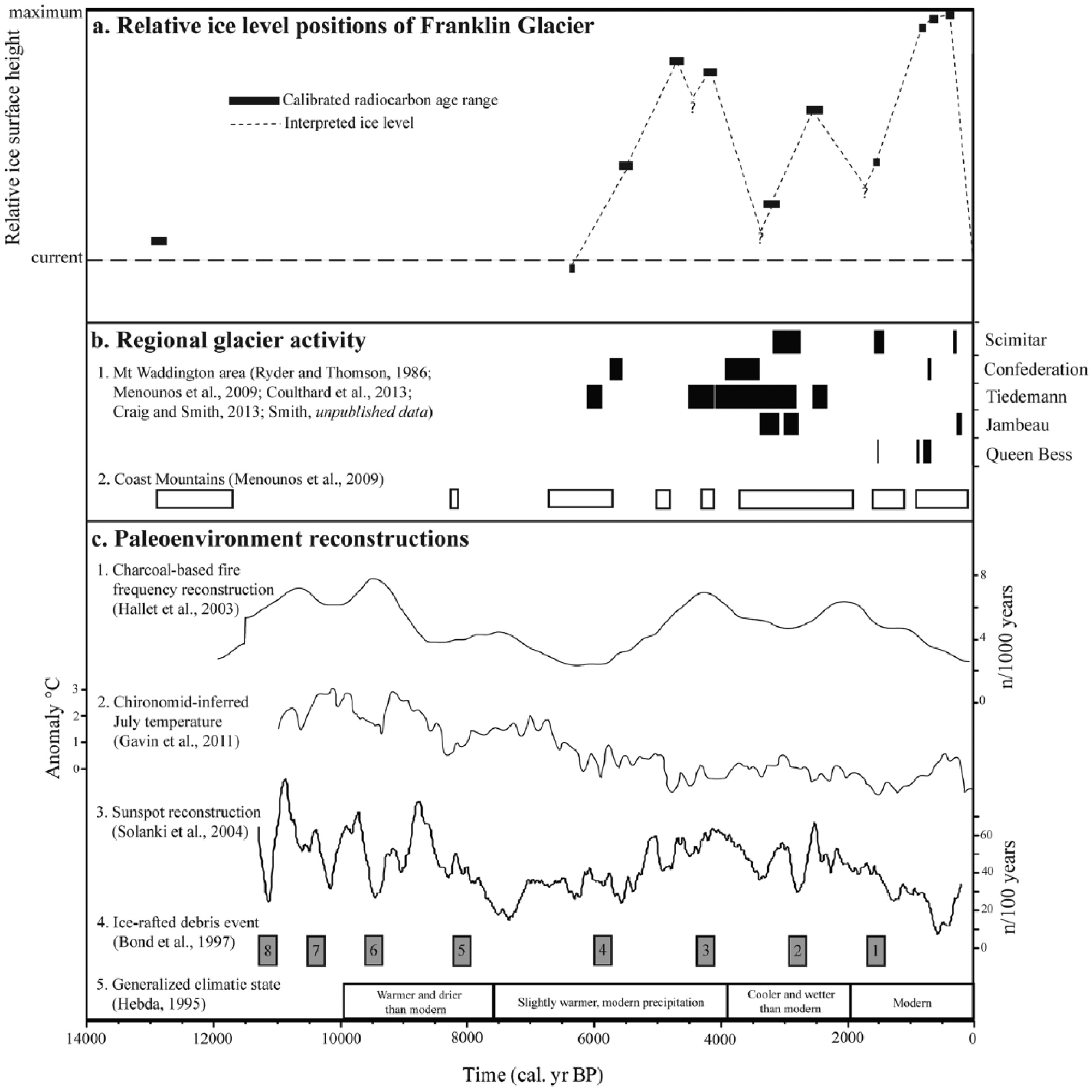
Radiocarbon-dated evidence at Franklin Glacier compared to regional and global proxy reconstructions and other evidence of glacier activity, shown in (a) relative ice surface height of Franklin Glacier over the past 14,000 years. Information derived from radiocarbon-dated wood samples and positions on the lateral moraine, where current 2013 ice surface position and maximum is the greatest extent during the ‘Little Ice Age’ (see Table 1 for details); (b) 1. – dated glacier advances of Franklin Glacier and at other sites in the Mt. Waddington area (see Table 1 for details). Black bars represent ±2σ error limits of calibrated 14C ages; 2. – regionally recognized phases of positive mass balance (Menounos et al., 2009); and (c) 1. – fire frequency record from the southern Coast Mountains (Hallet et al., 2003), 2. – July temperature anomaly record from interior British Columbia (Gavin et al., 2011), 3. – global sunspot reconstruction (Solanki et al., 2004), 4. – ice-rafted debris events in the North Atlantic (Bond et al., 1997) and 5. – generalized climatic states in southwest British Columbia (Hebda, 1995).
By 5470–5320 cal. yr BP, Franklin Glacier was expanding into a forest of mature trees at 1450 m a.s.l. (site 4), as were nearby Confederation and Tiedemann glaciers (Coulthard et al., 2013; Menounos et al., 2009; Table 1). This period of glacial expansion is recorded at several other Coast Mountain glaciers (Harvey et al., 2012) and was presumably a response to the establishment of cool, moist conditions (Galloway et al., 2011; Gavin et al., 2011) which also saw decreased forest fire activity in coastal and interior British Columbia (Hallet et al., 2003; Figure 6).
Following the advance at 5470–5320 cal. yr BP, Franklin Glacier appears to have down wasted before expanding close to its maximum ‘Little Ice Age’ position by 4770–4580 cal. yr BP (1410 m a.s.l.) during a period distinguished by cooler summer temperatures and increased winter precipitation (Hebda, 1995; Figure 6). These conditions were widespread (Galloway et al., 2011) and initiated glacier advances throughout the Coast Mountains (Harvey et al., 2012; Koehler and Smith, 2011; Menounos et al., 2009).
After the 4770–4580 cal. yr BP advance, Franklin Glacier thinned before expanding up the valley walls in 4260–4080 cal. yr BP during an interval of wetter, cooler climates (Hebda, 1995), characterized by low summer temperatures (Gavin et al., 2011), increased precipitation (Galloway et al., 2010) and decreased sea surface temperature (Bond et al., 1997; Figure 6). The burial of mature trees alongside Franklin Glacier at site 6 (1470 m a.s.l.) occurred synchronously with a sustained period of regional glacial expansion (Menounos et al., 2008; Osborn et al., 2007, 2013; Figure 6).
Glaciers in the Mt. Waddington area (Clague et al., 2009; Coulthard et al., 2013) and throughout western Canada (Menounos et al., 2009) were expanding at many locations at ca. 3000 cal. yr BP during a prolonged interval of cooler temperatures (Gavin et al., 2011) and decreased forest fire frequency (Hallet et al., 2003; Figure 6). Franklin Glacier also advanced during this period, overwhelming and burying tree trunks dated to 3210–3020 cal. yr BP at site 7. Following the 3210–3020 cal. yr BP advance, Franklin Glacier retreated before readvancing into a mature standing forest in 2620–2380 cal. yr BP at site 8 (1430 m a.s.l.). There are similar records of glacial expansion at this time at nearby Scimitar and Tiedemann glaciers (Arsenault et al., 2007; Craig and Smith, 2013; Figure 6, Table 1), as well as at other glaciers in Pacific North America (Barclay et al., 2013; Koehler and Smith, 2011; Osborn et al., 2013). The regional character of these advances suggests that they were a positive mass balance response to a large-scale climate perturbation (Galloway et al., 2011).
Following the 2620–2380 cal. yr BP advance, Franklin Glacier down wasted and retreated, with no evidence for subsequent expansion until 1570–1480 cal. yr BP (site 9) during a broadly recognized period of glacier activity in western North America (Jackson et al., 2008; Reyes et al., 2006). In the Mt. Waddington area, contemporaneous advances were underway at Queen Bess and Scimitar glaciers (Table 1 and Figure 6) during a period of increased precipitation (Steinman et al., 2014). The global signature of ice expansion during this period suggests that climate deterioration related to millennial-scale cycles (Bond et al., 1997) may have played a significant role in contemporaneous glacier activity.
After the 1570–1480 cal. yr BP advance, Franklin Glacier down wasted and retreated before expanding into mature valley side forests (>400 years old) during the early ‘Little Ice Age’ (Coulthard et al., 2013; Ryder and Thomson, 1986). Distinct advances at 800–680, 610–560 and 570–510 cal. yr BP saw Franklin Glacier thicken to a position close to those achieved during the following late ‘Little Ice Age’. Contemporaneous early ‘Little Ice Age’ expansion is recorded at many glaciers in the Mt. Waddington area (Larocque and Smith, 2003; Table 1), reflecting the cool wet environment in the Coast Mountains at this time (Arsenault et al., 2007; Babalola et al., 2013; Larocque and Smith, 2005a; Pitman and Smith, 2012; Steinman et al., 2014).
Observations and photographs by Munday (1931a, 1934–1935) indicate that Franklin Glacier receded before expanding down valley to reach its maximum ‘Little Ice Age’ extent in the mid-19th to early 20th century. Based upon findings at other glaciers in the Mt. Waddington area (Craig and Smith, 2013; Larocque and Smith, 2003; Figure 6), the late ‘Little Ice Age’ advance of Franklin Glacier likely began prior to the mid-1700s in response to an extended interval of colder temperatures (Larocque and Smith, 2005a, 2005b; Pitman and Smith, 2012). Erosion of bedded lacustrine sands following draining of a moraine-dammed lake at site C (1357 m a.s.l.; Figure 3h) exposed a wood fragment indicating establishment of the late ‘Little Ice Age’ moraine was complete by 150 ± 70 14C yr BP (290–0 cal. yr BP; S-1475, Table 1).
The dendroglaciological record emerging from the Mt. Waddington area indicates that glaciers repeatedly expanded during the middle to late Holocene into forests on the proximal slopes of lateral moraines flanking Franklin Glacier valley. This behaviour is consistent with the record of fluctuations in solar activity during the Holocene (Solanki et al., 2004) and corresponding ice-rafted debris events in the North Atlantic (Bond et al., 1997) at ca. 5900, 4200, 2800 and 1400 cal. yr BP (Figure 6). Similar causal relationships have been identified as presumed drivers for glacier expansion elsewhere in Pacific North America (Wiles et al., 2004) and serve to emphasize the role that synergistic, global climate cycling plays in establishing long-term trends in glacier behaviour.
Conclusion
Dendroglaciological evidence from Franklin Glacier provides insight about the latest Pleistocene and Holocene behaviour of glaciers in the Mt. Waddington area. The equivocal evidence for ice expansion at Franklin Glacier at 12,910–12,690 cal. yr BP during the Younger Dryas cold event is in contrast to findings elsewhere in the Coast Mountains and northern British Columbia. Our observations, if correct, may signify that present understanding of Younger Dryas glacier activity in the North American Cordillera remains incomplete.
Following warm conditions during the early Holocene, Franklin Glacier repeatedly advanced into valley side forests. Mid-Holocene advances at 6360–6280, 5470–5280 and 4770–4580 cal. yr BP show progressive ice thickening followed by minor retreats prior to expansion at 4260–4080 cal. yr BP (Figure 6). Subsequent advances occurred at 3210–3020 and 2620–2380 cal. yr BP. Franklin Glacier retreated after the 2620–2380 cal. yr BP advance, with no record of expansion again until 1570–1480 cal. yr BP. The glacier attained its Holocene maximum vertical extent during the ‘Little Ice Age’ and remained close to this position until the 1920s, after which it subsequently underwent significant down wasting and continued frontal retreat.
The dendroglaciological record at Franklin Glacier is among the most comprehensive recovered from the Coast Mountains and showcases the complexity of glacial activity in this region over the past ca. 6000 years. The discovery of multiple episodes of mid- to late Holocene glacier expansion strengthens our understanding of the impact of long-term climate changes on the Holocene behaviour of glaciers in the Coast Mountains. Notable are the corresponding records of relative volumetric changes experienced by Franklin Glacier over the Holocene, which have implications for furthering our understanding of the impact of ongoing climate changes on glaciers throughout this region.
Footnotes
Acknowledgements
We thank A. Charbonneau, J. Harvey, K. Hoffman and V. St-Hilaire for assistance in the field. Earlier versions of this manuscript were improved with comments provided by J.J. Clague, D. Clark and several anonymous reviewers.
Funding
Financial support for the research was provided by the Natural Sciences and Engineering Research Council (NSERC) Discovery Grant (Smith) and NSERC Canadian Graduate Scholarship (Mood).