
Abstract
Intercorrelated terrestrial and marine records from New Zealand, Chile and Argentina provide the first evidence of a coherent pan-Pacific response to the growing influence that El Niño-Southern Oscillation (ENSO) and multicentury variations in the interaction between ENSO and the Southern Annular Mode (SAM) exerted on rainfall in the Southern Hemisphere mid-latitudes during the middle and late Holocene. Rainfall is also strongly influenced by moisture originating from the prevailing southern westerly winds (SWW), and we find that the variations in rainfall forced by the interaction of ENSO and the SAM are superimposed on an underlying long-term trend induced by a temporal strengthening of the westerly circulation. We conclude that the evolution of rainfall across the South Pacific reflects the influence seasonal insolation exerts on: (1) ENSO/SAM interactions; and (2) the strength of the SWW.
Keywords
Introduction
In New Zealand and elsewhere in the largely maritime Southern Hemisphere mid-latitudes, the interaction between the prevailing westerly atmospheric circulation, which is modulated by El Niño-Southern Oscillation (ENSO) and the Southern Annular Mode (SAM), and north–south trending topography produces distinctive precipitation patterns (Griffiths, 2006; Kidson and Renwick, 2002; Kidston et al., 2009; Ummenhofer and England, 2007). The influence that trends in these climate modes have on modern precipitation has been the subject of detailed investigation (Ummenhofer et al., 2009). However, a perspective on the effect they exerted before instrumental records began has only recently emerged (Gomez et al., 2012). In this paper we extend the hypothesis that ENSO and SAM interact to influence storm activity over northeastern New Zealand, by examining published, high-resolution paleoclimate records from the west-central region of the North Island and southern South America. First, we use the signature of large rainfall events preserved in Lake Tutira core LT24 (Orpin et al., 2010; Page et al., 2010; Figure 1), in conjunction with the sediment record from Poverty Shelf core MD972122 (Gomez et al., 2004a, 2007; Figure 1), to contextualize the regional response erosion processes had to variations in eastern North Island rainfall that were a product of interactions between ENSO and the SAM in middle and late Holocene. Then we consider variations in Holocene rainfall across the North Island, by comparing the Lake Tutira record with the master speleothem carbon isotope (δ13C) record from caves in the Waitomo district of the west-central North Island (Williams et al., 2004; Figure 1). To assess whether or not synchronous rainfall variations occurred further afield, we compare the New Zealand records from Poverty Shelf and Waitomo with the iron (Fe) content record in marine core GeoB 3313-1 from southern Chile (Lamy et al., 2001; Figure 1). Finally, we use the titanium (Ti) record from Laguna Potrok Aike, Argentina (Mayr et al., 2007; Figure 1), to gauge the influence that the underlying variability in the southern westerly winds (SWW) exerted on rainfall on opposite sides of the South Pacific.
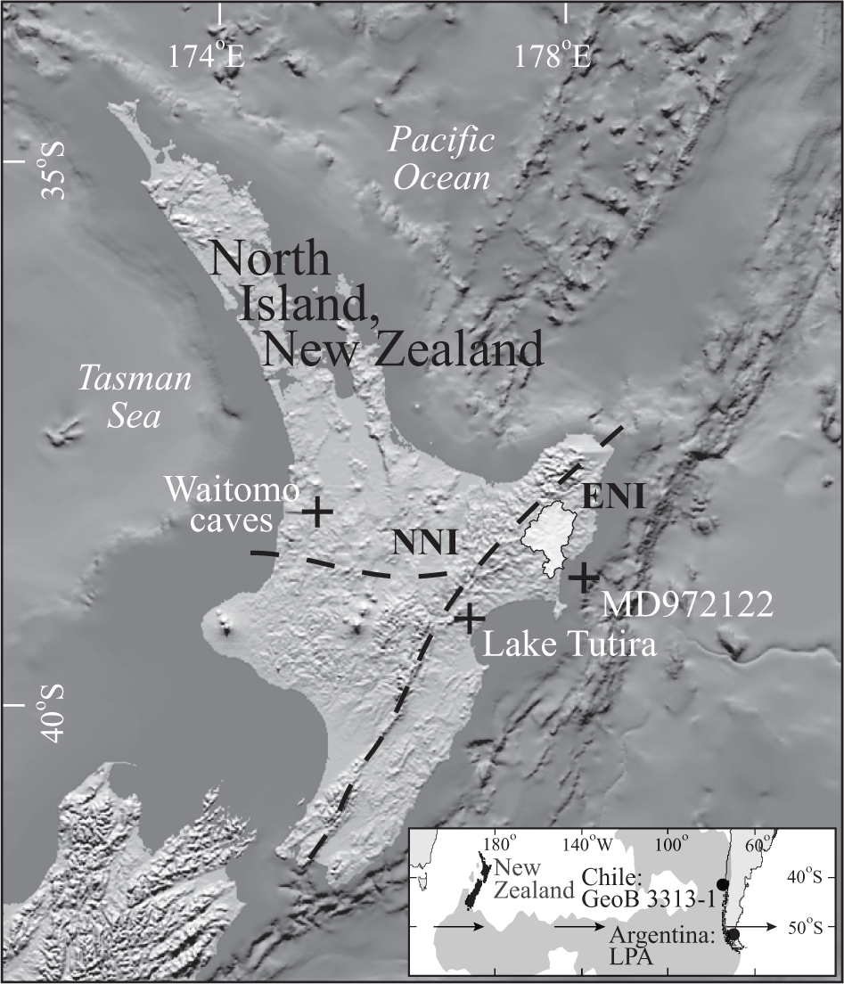
Location of the New Zealand and South American (inset) paleoclimate records used (LPA, Laguna Potrok Aike), and the Waipaoa River basin (light shading). The heavy dashed lines delimit the northern (NNI) and eastern (ENI) North Island’s regional climate regimes. Inset: arrows indicate the approximate latitude of the core of the modern southwesterly wind field (50°S), and the grey shading over the mid-latitude South Pacific Ocean denotes the area in which anomalies of the zonal flow aloft (300 hPa) explain >50% of the precipitation variance at monthly and longer timescales.
The ~7000 yr long Lake Tutira record is derived from terrigenous (silt and sand) deposits generated by mass-wasting processes operating during extreme rainstorms (Gomez et al., 2012; Page et al., 2010). Contemporaneously, the marine core from Poverty Shelf not only records changes in the mode and intensity of sediment production, but also the erosional response to rainfall events of diverse magnitude and frequency (Gomez et al., 2004a, 2007). Rainfall moderates the production and delivery of terrigenous sediment to both depocentres, by virtue of the fundamental control it exerts on soil moisture and runoff. Rainfall also influences the Waitomo speleothem δ13C record (Williams et al., 2004), by reinforcing the trend towards more (less) negative ratios when wetter (drier) conditions prevail; and the Fe content record from the Chilean continental slope, by diluting the Fe-rich sediment derived from Andean sources with Fe-poor detritus supplied by rivers draining the Coastal Ranges during more humid phases (Lamy et al., 2001). Similarly, Ti-bearing sediment is flushed into Laguna Potrok Aike when moisture derived from the Atlantic spills eastward as the prevailing SWW weaken (Mayr et al., 2007). Our synthesis of these diverse, well-studied, high resolution records, which we present in a uniform style, provides the first integrated overview of the influence that changes to teleconnections and the strength of the SWW had on rainfall across the South Pacific mid-latitudes during the middle and late Holocene.
Eastern New Zealand rainfall and sediment records
Precipitation is delivered to the North Island by weather systems emanating both from the subtropical Pacific Ocean and the Tasman Sea/Southern Ocean (Salinger et al., 2004). Trends in New Zealand precipitation during the latter decades of the 20th century are interpreted to reflect persistent periods of anomalous westerly/southwesterly and easterly/northeasterly airflow that are linked to changes in the mode and frequency of regional climate drivers, such as ENSO (Jiang et al., 2012; Salinger and Mullan, 1999). Enhanced southwesterly airflow across New Zealand during El Niño years brings less rainfall to the northern and eastern North Island in the austral winter and generally drier conditions to the remainder of the North Island, whereas the enhanced onshore (northeasterly) flow during La Niña can bring above normal rainfall to northern and eastern regions of the North Island in summer (Kidson and Renwick, 2002; Ummenhofer and England, 2007). Southern Hemisphere climatological records also indicate that the strength of the ENSO teleconnection to the middle and high latitudes is modulated by the SAM (Marshall, 2007). During the positive (negative) phase of the SAM an easterly to northeasterly (westerly) flow anomaly directs fewer (more) cyclonic rain-bearing weather systems across New Zealand but the east coast is wetter (drier) than other parts of the North Island because the effect of orographic lifting (subsidence) is locally dominant (Kidston et al., 2009). The teleconnection is amplified during the austral spring and summer when the two climate modes are in phase and La Niña (El Niño) coincides with the positive (negative) phase of the SAM (Fogt and Bromwich, 2006; Fogt et al., 2011); as occurred, for example, in 2011, when the anomalous northeasterly winds that accompany La Niña and a positive SAM generated well-above-normal annual rainfall throughout the northeast North Island (Griffiths, 2012). Conversely, the teleconnection weakens when the climate modes are out of phase.
Terrigenous sediment layers in core LT24 from Lake Tutira (39.22°S, 176.89°E; Figure 1) provide an uncensored and sensitive record of upland storm-driven erosional activity that initiated surface and channel erosion and shallow landslides on hillslopes in the surrounding 32 km2 catchment (Orpin et al., 2010; Page et al., 2010). Layer thickness and lithotype are positively correlated with storm rainfall, and an assemblage of 397 clay layers and sand-silt-clay graded beds records variations in the South Pacific atmospheric circulation linked to ENSO and the SAM, that combined to influence the frequency of the largest magnitude rainstorms (event rainfall ≥300 mm) during the middle and late Holocene (Gomez et al., 2012). Macklin et al. (2012) confirmed that the Lake Tutira storm sediment record consistently captures extreme hydrological events preserved in the New Zealand Holocene fluvial sedimentary record as a whole. Our own analysis shows that extreme events in the >100 yr long modern rainfall record typically occur in years when annual rainfall exceeds the mean, and months with storms account for up to 39% of the annual rainfall (Orpin et al., 2010).
The number of extreme rainfall events in the Lake Tutira archive varies over decadal to centennial timescales, and major periods of storm activity correlate with other Southern Hemisphere proxy climate data (Page et al., 2010). Periods of marked storminess occurred from 5700 to 5500; 5000 to 4600; 3300 to 3100; and 2100 to 1700 cal. yr BP, and there were lacunae in storm activity (≤2 storms per 100 yr) from 1700 to 1600 and 6500 to 6100 cal. yr BP (Figure 2). Synthesis of the Lake Tutira record with independent paleoclimate reconstructions from the equatorial Pacific and Antarctica suggests that periods of enhanced storm activity (≥16 large magnitude storms per 100 yr) occur when La Niña coincides with a positive SAM, whereas there are protracted lulls (≤1 large magnitude storm per 100 yr) when El Niño coincide with a positive SAM (Gomez et al., 2012). That is, erosional activity in the Lake Tutira catchment peaks (declines) when the ENSO teleconnection to New Zealand is amplified (weakens). The event time-histogram for large storms prior to human arrival at ~500 cal. yr BP is shown in Figure 2a. Details of the storm event chronologies are provided by Page et al. (2010) and Gomez et al. (2012).

(a) The Lake Tutira large-magnitude storm event histogram (black line; Gomez et al., 2012), and master speleothem carbon isotope (δ13C) record (grey line) from caves in the Waitomo district (after Williams et al., 2004). Note the inverted scale. The arrows and the operator in square brackets indicate the duration and sign of the statistically significant correlation between the Waitomo and Lake Tutira records, and grey shading draws attention to the time period when Gomez et al. (2012) suggest there was an in-phase relation between the low and high latitude climate modes that strengthened ENSO teleconnections to the extratropics. (b) MD972122 anhysteretic/isothermal (ARM/IRM) and hard isothermal (HIRM) remanent magnetization records. A variation in line color and weight indicates the point where change-point analysis shows the mean of the time-ordered data shifts, and shading periods of enhanced earthflow activity seen in the ARM/IRM record. Solid rectangles denote periods of enhanced storm activity in the Lake Tutira record and open rectangles periods when there were major lulls in storm activity. (c) MD972122 median particle size (D50; black line) and percent clay (grey bars) records. ‘T’ denotes the 1718 cal. yr BP Taupo eruption. Except for the Lake Tutira record, the data are 100 yr bin averages and there is a gap in the δ13C record because there were no data in the specified bin. Data binning effaces short-term variations in the magnetic and textural records that are not thought to be related to basin hydrometeorology, and uncertainties in the core chronology are ±100 yr. See Figure 1 for record locations.
Erosion and sediment production in the 2205 km2 Waipaoa River basin, which lies 110 km northeast of Lake Tutira (Figure 1), are determined by terrain stability and were modulated by second-order forcing resulting from climate, vegetation and land-use change in the middle and late Holocene (Gomez et al., 2007; Kettner et al., 2007). Water and suspended sediment discharge depend mainly on rainfall, but fluctuations in the caliber of the sediment load that are a product of vegetation and land-use change also translate directly to the marine record preserved in core MD972122 (38.81°S, 178.17°E; Figure 1), from Poverty Shelf (Kettner et al., 2007, 2009). Here the sedimentary-source signature is coherent with variations in sediment geochemistry, texture and environmental magnetic parameters that record the lithological response to multicentury-long periods of landscape instability and intensified hillslope erosion (Gomez et al., 2007). After the major phase of postglacial incision culminated at 5580 cal. yr BP (Gomez and Livingston, 2012), mass wasting regraded most (>70%) of the valley side slopes in the headwaters of the Waipaoa River basin by ~3410 cal. yr BP (Gage and Black, 1979). Gully erosion generates most of the suspended sediment that the modern river delivers to the shelf, but under a native forest cover the sediment supply regime appears to have been dominated by influxes of material from shallow landslides activated during high-magnitude rainstorms (Gomez et al., 2004b).
Anhysteretic remanent magnetization (ARM) and isothermal remanent magnetization (IRM) are sensitive to changes in the concentration of fine and coarse magnetic particles, respectively. We use the ratio of ARM to IRM, which varies in concert with the amount of clay present in MD972122 (Gomez et al., 2007), as a magnetic grain-size indicator. Hillslopes in the Waipaoa River basin that are prone to shallow landsliding and subject to scour by surface runoff release relatively coarse material (D50 >15 μm) into river channels, whereas mass wasting by earthflows and large, deep-seated landslides on hillslopes in the headwaters, as well as river incision, generates fine silt-clay (D50 <10 μm). Time histograms of the magnetic and textural parameters for the period prior to human arrival were derived from original measurements made at 0.01 m intervals using a 100 yr bin average (Figure 2b, c).
Regional response
After the termination of the postglacial phase of incision in the Waipaoa River basin (at 5580 cal. yr BP) the shelf sediment record coarsened, as the volume of fine sediment generated by incision and mass wasting declined and the supply of coarse sediment resulting from erosion processes that remove soil from hillslopes, such as shallow landsliding and scour by surface runoff, increased over time (Gomez et al., 2004a). Thus the magnetic and textural data from MD972122 exhibit coeval trends (Figure 2b and c). Cumulative sum change-point analysis (Taylor, 2000), performed after errors due to positive correlation were eliminated by averaging across three consecutive bins, indicates that a level 1 change (the first change detected, 100% confidence level determined by bootstrapping) occurs in the ARM/IRM and HIRM records at 4000 and 3400 cal. yr BP, respectively (Figure 2b). Gomez et al. (2004a) equated the shift at 4000 cal. yr BP with an ENSO-driven increase in storminess, which enhanced soil loss from hillslopes in the Waipaoa River basin (Figure 2b and c). Our statistical analysis permits us to refine this interpretation and address the cause of the shift at 3400 cal. yr BP.
There is coherence between terrestrial and marine records, with periods of increased storm activity of several centuries duration at Lake Tutira mirrored by peaks in ARM/IRM offshore that are tagged to source variability (Figure 2). The changing imprint of mass wasting preserved by ARM/IRM is consistent with the observation that measured rates of surface displacement correlate with rainfall and increase during wet periods (Zhang et al., 1993). We suggest that the contribution made by mass wasting increased at times when ENSO teleconnections to the South Pacific were amplified, and conditions typical of La Niña were reinforced by a positive SAM. This likely occurred between 2100 and 1800 cal. yr BP (Gomez et al., 2012), and the prevalence of generally wetter conditions at this time is corroborated by a local pollen record (McGlone, 2002). By contrast, during drier periods, when storm activity at Lake Tutira was low and mass wasting suppressed, soil erosion on hillslopes generated a greater proportion of the sediment stored on the middle shelf. Climate-related shifts in the intensity erosional activity are also seen in the HIRM record; for example, for the 200 yr after 3400 cal. yr BP when soil erosion (that may have accelerated after the 3410 ±40 cal. yr BP Waimihia eruption disrupted the vegetation cover) first began to dominate. By increasing landscape sensitivity to erosion in sediment sources areas, events such as the Waimihia and 1718 cal. yr BP Taupo eruptions perturb sediment characteristics, but do not alter the overall long-term (millennial-scale) lithological response to climate (Figure 2c; Gomez et al., 2007). For this reason we suggest that the interaction between the principal modes of Southern Hemisphere climate variability is one of the dominant, long-term influences on the sedimentological proxies (Figure 2b and c). The composite lithological signals in cores MD972122 and LT24 also provide strong evidence for a coherent regional response to interactions between ENSO and the SAM during the middle and late Holocene.
North Island and pan-Pacific response
Regional variability in rainfall across New Zealand reflects interactions between the zonal atmospheric circulation and the north–south trending ranges (Kidson and Renwick, 2002; Kidston et al., 2009; Ummenhofer and England, 2007), and it has been suggested that precipitation patterns responded to changing atmospheric circulation patterns in the late Holocene (Lorrey et al., 2008). The δ13C composition of speleothems from caves in the Waitomo district (38.2°S, 175.1°E; Figure 1) has yielded a well-dated, high-resolution paleoenvironmental record for the west-central North Island (Williams et al., 2004). Mindful of the factors than affect speleothem δ13C composition, in the context of maritime New Zealand in the Holocene, with only C3 vegetation, Williams et al. (2004) concluded that more (less) negative δ13C values most likely represent wetter (drier) conditions. Four stable isotope chronologies underpin the master record, which is the basis for our time histogram (Figure 2a).
To investigate coherence in rainfall across the North Island, we used the critical value for a one-tailed test to gauge the significance level (α) of Spearman’s rank order correlation coefficient and quantify associations between the Lake Tutira and Waitomo records. There is no a priori reason to expect that these (or any other) regional archives will align exactly, because of differences in dating control. However, we find the Waitomo and Lake Tutira large storm records were negatively correlated (α = 0.02) between 4900 and 2100 cal. yr BP (Figure 2a), when the in-phase relation between ENSO and the SAM strengthened the ENSO teleconnection to New Zealand (Gomez et al., 2012). The same correlation emerges when the complete Lake Tutira storm sediment record is used (not shown), and the lack of any correlation between the two records before 4900 and after 2100 cal. yr BP is consistent with the present climate regime and the situation that occurs when, for example, La Niña coincides with a positive SAM. At such times enhanced northeasterly airflows bring generally drier conditions to most of the western and southern North Island, but more rain to the eastern North Island (Kidson and Renwick, 2002; Kidston et al., 2009; Ummenhofer et al., 2009). The SAM’s influence appears to dominate, and >80% of the present negative trends in precipitation over the North Island can be accounted for by variability in the SAM (Ummenhofer et al., 2009). However, when ENSO and the SAM are in-phase, we suggest that, for example, during La Niña the enhanced connection to the topics may be strong enough to efface the summer precipitation minima in the Waitomo district (cf. Kidson and Renwick, 2002). Winter rainfall may similarly be affected because less precipitation falls on the northern North Island during El Niño (Kidson and Renwick, 2002). That is, an enhanced connection to the topics modifies, but does not change the way the North Island climate system operates.
Beyond New Zealand, other paleoclimate reconstructions from southern middle latitudes also record ENSO’s influence on rainfall patterns during the middle and late Holocene. In core GeoB 3313-1 (41°S, 74.5°E; Figure 1), from the southern Chilean upper continental slope, variations in Fe content are linked to precipitation falling on coastal watersheds (Lamy et al., 2001). The long-term trend in this record is consistent with the strengthening of ENSO, which began to exert more influence on rainfall variability over central Chile during the mid Holocene. Comparison of the bin-averaged time histogram for GeoB 3313-1, with the two New Zealand records that are also influenced by rainfall events of diverse magnitude and frequency, reveals: (1) a negative correlation (α = 0.01) with the MD972122 textural record after 4900 cal. yr BP, when ENSO teleconnections to the extratropics strengthened (Gomez et al., 2012); and (2) a positive correlation (α = 0.01) with the Waitomo δ13C record after 4000 cal. yr BP (Figure 3a). Correlations of different signs are consistent with the out-of-phase rainfall totals for the west and east coast of the North Island, where ENSO exerts most influence (Salinger et al., 2001).

(a) MD972122 median particle size (D50), GeoB 3313-1 iron (Fe) concentration, and Waitomo district master speleothem carbon isotope (δ13C) records (after Lamy et al., 2001 and Williams et al., 2004). Note the inverted scales. The data are 100 yr bin averages and a variation in line color and weight indicates the point where change-point analysis shows the mean of the time-ordered iron concentration data shifts. Black lines and arrows indicate the duration and operators in square brackets the sign of the statistically significant correlations between the Chilean and New Zealand records, and grey shading draws attention to the time period when Gomez et al. (2012) suggest there was a strong connection between the low and high latitude climate modes. (b) Laguna Potrok Aike, Argentina, titanium (Ti) record (solid line). The data are 100 yr bin averages, a variation in line color and weight indicates the point where change-point analysis shows the mean of the time-ordered data shifts, and shading the duration of the statistically significant correlations between the Laguna Potrok Aike, Waitomo, GeoB 3313-1 and MD972122 records. Dashed line shows the trend in simulated, average (for January, April, July and October), near-surface, wind speed between 45° and 60°S (deviation from the 1000–250 cal. yr BP, preindustrial mean) associated with the orbitally forced evolution of the meridional temperature gradient (after Renssen et al., 2005). See Figure 1 for record locations.
Influence of the southern westerly winds
Rainfall in central Chile is also strongly influenced by moisture originating from the SWW (Garreaud, 2007; Garreaud et al., 2009), and the core of the modern wind field (which extends between 30° and 70°S) lies just south of New Zealand at ~50°S (Figure 1). The stronger, poleward-shifted and weaker, equatorward-shifted patterns of the SAM’s positive and negative phases reflect the dominant mode of SWW variability, which is also manifest in other atmospheric variables, such as storm track activity and precipitation (Brahmananda Rao et al., 2003; Gillett et al., 2006). A level 1 change (100% confidence level) occurs in the GeoB 3313-1 record at 4000 cal. yr BP, after which time the GeoB 3313-1 and Waitomo records are positively correlated. This may signal a shift in the position and strength of the SSW, that is analogous to a long-term trend towards a more positive phase of the SAM (Varma et al., 2012), and is coincident with the changes within the tropical climate system that also began to exert more influence on rainfall variability at this time (Lamy et al., 2001).
The Ti record from Laguna Potrok Aike, Argentina (51.96°S, 70.39°W; Figure 1), is a high-resolution proxy for SWW strength (Mayr et al., 2007). The lake’s 200 km2 catchment lies in the Andean rain shadow on the semi-arid Patagonian steppe, where the SWW govern climate and the easterly winds that bring most precipitation dominate only when the westerly winds weaken. Ti-bearing sediment flushed into the lake during easterly wind-driven events provides evidence for periods of enhanced (reduced) fluvial runoff and weaker (stronger) SWW (indexed by a high (low) Ti concentration) of multicentury duration (Mayret al., 2007). We note that the overall increase the strength of the SWW recorded at Laguna Potrok Aike is consistent with the trend in wind speed that emerged from Renssen et al.’s (2005) numerical simulations (Figure 3b), as the meridional temperature gradient evolved in response to orbital forcing during the middle and late Holocene (cf. Lamy et al., 2010; Moreno et al., 2009; Varma et al., 2012). Coincident with a change in lithology that signals the onset of drier conditions and lower lake or receding water levels (Haberzettl et al., 2007), there is a level 1 change (100% confidence level) in the record at 3500 cal. yr BP. We also find that the bin-averaged Laguna Potrok Aike and GeoB 3313-1 records are positively correlated (α = 0.01) after 5900 cal. yr BP, when (5880 cal. yr BP) the pollen record from Laguna Potrok Aike suggests that the wind and precipitation systems became more variable (Wille et al., 2007).
Anomalies of the zonal flow aloft (300 hPa) explain >50% of the precipitation variance at monthly and longer timescales over large portions of the mid-latitude South Pacific between New Zealand and South America (Figure 1), and 30% to 60% of the variance across most of this region (Garreaud, 2007). The positive correlation arises because strong westerly winds aloft facilitate the rapid growth and succession of rain-bearing, baroclinic disturbances. Any change in the SWW would also have affected the western North Island, and the Waitomo and Laguna Potrok Aike records are negatively correlated (α = 0.01) over the same time period. That is, after 5900 cal. yr BP weaker (stronger) SWW, indexed by the Ti record from Laguna Potrok Aike, are linked with generally drier (wetter) conditions in both the GeoB 3313-1 and Waitomo records. Paleoclimate models also suggest there was a circulation change over New Zealand at about this time (Ackerley et al., 2011). Consistent with the dependence that extreme rainstorms and shallow landslides have on interrelations between La Niña and the SAM (Gomez et al., 2012), there is no correlation between the Laguna Potrok Aike and Tutira records (either for large or all sediment producing storms). Conversely, there is a strong positive correlation (α = 0.01) between the Laguna Potrok Aike and MD972122 textural (D50) records. Owing to New Zealand’s topography, stronger SWW are associated with decreased precipitation on the East Coast of the North Island (Salinger and Mullan, 1999). However, most of the precipitation that falls on the Waipaoa River basin is of frontal origin, and stronger SWW would have caused an overall increase in rainfall from systems embedded in the westerly flow (cf. Salinger and Mullan, 1999). We construe that: (1) the correlation between the Laguna Potrok Aike and MD972122 (D50) records, and (2) the subsequent shifts in the Ti and HIRM records, at 3500 and 3400 cal. yr BP, which signal the onset of drier conditions at Laguna Potrok Aike and increased hillslope erosion in the Waipaoa River basin (Figures 2b, c and 3b), together reflect large-scale changes to the prevailing westerly airflow.
Consistent with the strengthening of the westerly atmospheric circulation, there was also an ENSO-driven ancillary decline in the fluvial input of fine sediment to Poverty Shelf after 4000 cal. yr BP (Gomez et al., 2004a; Figure 2b). This suggests the intensification of ENSO was accompanied by a more persistent westerly/southwesterly airflow. In such circumstances, as evinced by the modern sedimentation pattern (Wood, 2006), a stronger southerly swell and south to southwest wind forcing of the local circulation would have enhanced sediment resuspension and reduced clay accumulation at MD972122.
Summary and conclusion
The geographic footprint of Holocene climate variability in the largely maritime South Pacific mid-latitudes is indistinct, but a storm sediment record from Lake Tutira provides the template against which the influence ENSO and the SAM exert on North Island rainfall can be gauged (Figure 2). Lake Tutira registers periods of enhanced storminess, of several centuries duration. These occurred when the low- and high-latitude climate modes persistently reinforced one another and generally wetter conditions prevailed on the eastern North Island (Gomez et al., 2012). Terrestrial-source and shelf-sink records show lithological coherence, with synchronous peaks in the MD972122 ARM/IRM record indicative of enhanced mass wasting in the adjacent Waipaoa River basin (Figure 2b), where rainfall intrinsically determines the relative levels at which erosional processes operate. There is a negative correlation between the Lake Tutira storm sediment record and the speleothem δ13C record from the Waitomo district in the western North Island between 4900 and 2100 cal. yr BP (Figure 2a), when an in-phase relation between ENSO and the SAM strengthened the teleconnection to New Zealand.
The proxy record for SWW strength from Laguna Potrok Aike, Argentina, correlates with the GeoB3313-1, Waitomo and MD972122 records after 5900 cal. yr BP (Figure 3b). This is about the time it is suggested the hemispheric circulation changed (Ackerley et al., 2011; Waldmann et al., 2010; Wille et al., 2007), and a stronger westerly flow is thought to have brought generally wetter conditions to southern Chile and the North Island. However, persistent large-scale pressure patterns, such as ENSO and the SAM, influence the extra-tropical atmospheric circulation by disrupting the zonal flow (Garreaud, 2007; L’Heureux and Thompson, 2006). The GeoB3313-1 and MD972122 records are negatively correlated after 4900 cal. yr BP, when the connection between the high and low climate modes strengthened (Gomez et al., 2009), which is consistent with enhanced (reduced) rainfall in southern Chile during El Niño (La Niña), and correspondingly drier (wetter) conditions across the east of the North Island (Garreaud et al., 2009; Kidson and Renwick, 2002; Lamy et al., 2001; Ummenhofer and England, 2007). The GeoB; 3313-1 and Waitomo records are positively correlated from 4000 cal. yr BP (Figure 3), when the tropical climate system began to exert more influence on rainfall variability in central Chile and west central North Island summers became drier (wetter) during El Niño (La Niña) (Lamy et al., 2001; Williams et al., 2004).
Climatic information embedded in the high-resolution records we have examined highlights the influence that variability in ENSO, the SAM, and the SWW exerts on New Zealand and southern South American rainfall. These records demonstrate the utility and importance of proxy information to the quantitative assessment of Holocene climate variability over timescales not captured by instrumental records. The emerging consensus they yield is that the growing influence of ENSO and the changing relations between ENSO and the SAM were principal drivers of low-frequency climate change throughout the South Pacific mid-latitudes during the middle and late Holocene. These interactions are superimposed upon rainfall patterns that are strongly influenced by moisture originating from the SWW.
By virtue of the influence it exerts on meridional temperature gradients, multimillennial-scale changes in atmospheric circulation have long been thought to be driven by solar insolation (Dodson, 1998). We conclude that orbital forcing influences rainfall across the South Pacific mid-latitudes on two levels, through the control changes in seasonal insolation exert on: (1) interactions between ENSO and the SAM (Gomez et al., 2012); and (2) the strength of the SSW (Lamy et al., 2010; Moreno et al., 2009; Renssen et al., 2005; Varma et al., 2012), upon which the contributions made by the different modes of Southern Hemisphere climate variability are superimposed.
Footnotes
Acknowledgements
We thank Hans Renssen for access to the simulated wind speed data.
Funding
This work was supported by New Zealand Foundation for Research, Science and Technology contracts C05X0705 (BG, NAT, MJP), VICX0704 (LC), CO1X0702 (ARO).