
Abstract
A new sedimentary sequence from Lago di Venere on Pantelleria Island, located in the Strait of Sicily between Tunisia and Sicily was recovered. The lake is located in the coastal infra-Mediterranean vegetation belt at 2 m a.s.l. Pollen, charcoal and sedimentological analyses are used to explore linkages among vegetation, fire and climate at a decadal scale over the past 1200 years. A dry period from
Keywords
Introduction
Few palaeoenvironmental reconstructions are available from near the Mediterranean coast that combine independent proxies for climate, vegetation, and fire at high temporal resolution. Consequently, it is difficult to ascribe the importance of climatic change for vegetation dynamics in heavily disturbed Mediterranean ecosystems. Furthermore, instrumental records do not extend through transitions between interesting climatic anomalies during the last millennium such as the ‘Medieval Warm Period’ (MWP) and ‘Little Ice Age’ (LIA). To fill these gaps we carried out a multiproxy palaeoclimatic and palaeoecological investigation at Lago di Venere, Pantelleria for the last 1200 years.
Pantelleria is a small island (83 km2) in the central Mediterranean Sea, 70 km east of Tunisia and 100 km southwest of Sicily (Figure 1). The island has a small lake of volcanic origin, Lago di Venere, that established c. 50,000 years ago (Civetta et al., 1988). Lago di Venere is one of very few natural, low-elevation lakes near the Mediterranean coast. This rarity, in combination with the rapid accumulation of carbonate-rich sediments makes Lago di Venere a prime target for palaeoenviromental and palaeoclimatic studies.
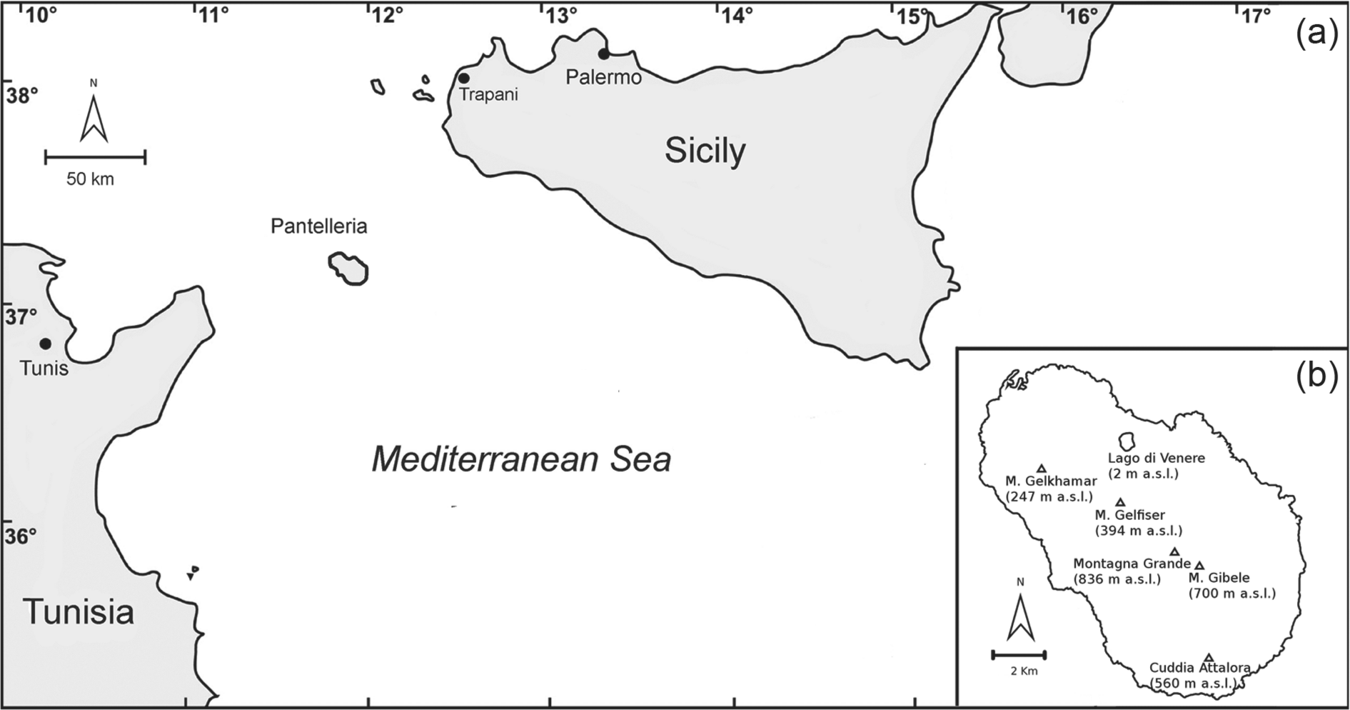
(a) Map showing the position of Pantelleria Island in the Sicily channel of the Mediterranean Sea. (b) Detailed map of Pantelleria Island with the location of Lago di Venere and major peaks.
No information is available from Pantelleria about long-term vegetation history, or how vegetation was impacted by climate and human disturbances such as grazing and fire. Vegetation change in the Mediterranean region is widely ascribed to changing moisture availability and human disturbance (Roberts et al., 2011). For example, arboreal vegetation expanded at low elevation near Pantelleria in Sicily and Malta when moisture availability increased about 7000 cal. yr BP (Calò et al., 2012; Djamali et al., 2013; Noti et al., 2009; Tinner et al., 2009). However, after the Neolithic period (c. 5000
We used a multiproxy approach with (1) x-ray fluorescence (XRF) to develop calcium content of Lago di Venere sediments as a proxy for changes in moisture availability, (2) pollen for inferring vegetation history and (3) charcoal analyses for reconstructing past fire activity. The palaeoclimatic record is then used to disentangle climatic and anthropogenic causes of vegetational and fire-regime changes. The reconstruction, with decadal-scale resolution, offers new insights into the linkages among climate change, land use and vegetation dynamics over the last millennium in the central Mediterranean.
Environmental settings
The basin ‘Lago di Venere’ (also known as ‘Specchio di Venere’ or ‘Bagno dell’Acqua’; 2 m a.s.l., 36°49′ N, 11°59′ E) lies on Pantelleria Island, which is located in the centre of the rift zone of the Strait of Sicily, between Tunisia and Sicily (Figure 1a). Pantelleria is the top of a large late-Quaternary volcano, mainly formed by volcanic rocks erupted about 324,000 yr BP (Mahood and Hildreth, 1986). The island has a surface of 83 km2 and is predominantly formed by acid and silicic vulcanites (pantellerites and trachytes: Aiuppa et al., 2007). The shape is elliptic (orientation NW–SE), with a coastline 51.5 km long. The highest point on the island is Montagna Grande (836 m a.s.l.), an inactive volcano, that along with Monte Gibele (700 m a.s.l.) and Cuddia Attalora (560 m a.s.l.), forms the mountainous southeastern part of Pantelleria (Figure 1b). The northwestern part of the island is mostly characterized by hills (e.g. Mt Gelfiser 394 m a.s.l. and Mt Gelkhamar 247 m a.s.l.).
Lago di Venere is an endorheic saline basin within a calderic depression that formed approximately 50,000 years ago during the ‘Green Tuff’ ignimbrite eruption (Civetta et al., 1988). The lake is about 450 m long and 350 m wide, with a maximum water depth of c. 12.5 m. There is no outlet or inlet, thus rainfall and hydrothermal springs are the only water inputs (Aiuppa et al., 2007). The climate of Pantelleria is typically Mediterranean, characterized by hot, dry summers and mild winters that provide most of the annual rainfall (Figure 2). Mean July temperature (1961–1990) at 170 m a.s.l. is 25°C, mean January temperature 12°C and mean annual temperature 18°C, while mean annual precipitation is 485 mm (Figure 2). More than 70% of the total precipitation falls in the period from October to February (Gianguzzi, 1999). The pronounced summer drought is not the only factor influencing the vegetation on the island: salty winds are recorded 337.5 days per year and cause severe water stress on vegetation because of increased transpiration losses. However, the wet winds that hit Montagna Grande (836 m a.s.l.) often induce fog on the uppermost part of the island (Gianguzzi, 1999), where the microclimate is milder and wetter.
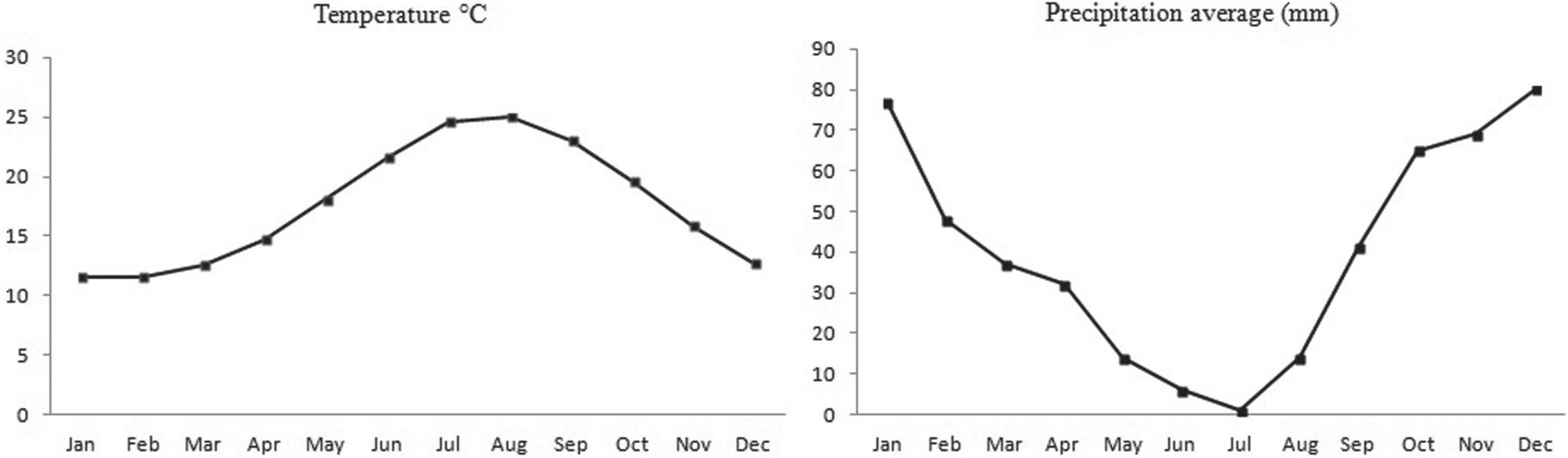
Average temperature and precipitation recorded at the weather station on Pantelleria Island at 170 m a.s.l. during the period 1971–2000.
Pantelleria is characterized by high plant species richness, with the presence of several endemic species such as Helichrysum errerae Tin., Limonium cosyrense (Guss.) O. Kuntze, Matthiola incana (L.) R. Br. subsp. pulchella (P. Conti) Greuter & Burdet in the coastal zone, and Limonium secundirameum (Lojac.) along the shore of Lago di Venere (Gianguzzi, 1999). Three main bioclimatic belts have been identified on the island (Gianguzzi, 1999). The infra-Mediterranean semiarid belt (0–200 m a.s.l.), prone to salt-spray and aridity, is mainly characterized by maquis (Juniperus turbinata Guss. and Periploca angustifolia Labill.). Thermo-Mediterranean (evergreen) vegetation covers most of the island (200–450 m a.s.l.). This zone includes relict forest communities of Quercus ilex as well as remnants of coastal Pinus halepensis Mill. forest in the south, where warm African winds constantly hit the island. In the evergreen-broadleaved Q. ilex-dominated forests, Erica arborea L., Arbutus unedo L., Lonicera implexa Aiton, Pistacia lentiscus L., Daphne gnidium L., Smilax aspera L. and Phillyrea latifolia L. co-occur. Where recently disturbed, the thermo-mediterranean vegetation type is characterized by Pistacia lentiscus, Euphorbia dendroides L., Olea europaea L. var. sylvestris (Mill.) Lehr. and Teucrium fruticans L. Cooler and moister environmental conditions characterize the meso-mediterranean vegetation of the top of Montagna Grande (836 m a.s.l.), where the mean annual temperature is below 16°C. In this area, Pinus pinaster grows in association with Myrtus communis, Erica arborea and Arbutus unedo, partially covered by mosses and lichens. It is unclear whether deciduous trees ever populated the island naturally. Reliable sources report the presence of evergreen and deciduous oaks on Pantelleria Island, with timber suitable for ship building (Furia, 1863; Smyth, 1824). Historical documents also mention Castanea sativa Mill. (D’Avezac, 1848; Furia, 1863; Smyth, 1824), of which a few scattered individuals still remain, and even Fagus sylvatica L. (Furia, 1863).
Material and methods
Coring and dating
Two parallel cores (VEA and VEB) were extracted from Lago di Venere in summer 2008 with a modified Livingstone corer 4.8 cm in diameter (Lang, 1994). The cores were recovered from the deepest lake basin in 11 m water depth. The cores were visually correlated using prominent lithological layers to produce a continuous sedimentary sequence. The master core contains mostly sections from core VEB and was in total 10.29 m. The sediments of core VEB between 516 and 451 cm show various degrees of folding and therefore have been interpreted as a slump.
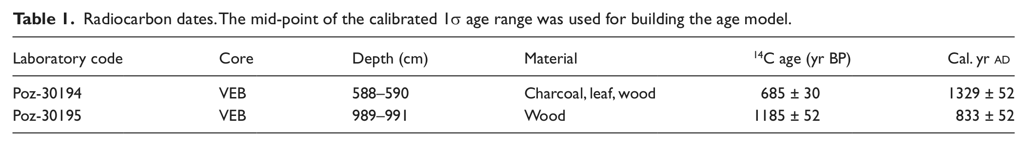
Terrestrial plant macrofossils (leaf, wood and charcoal) from core VEB were used for Accelerator Mass Spectrometry (AMS) analyses to infer radiocarbon dates (Table 1). The dates were converted to calibrated ages (cal. yr
Radiocarbon dates. The mid-point of the calibrated 1σ age range was used for building the age model.
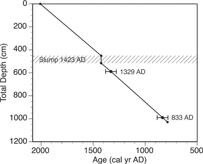
Radiocarbon dating of the sediments of Lago di Venere. Error bars show the 1σ error range of the calibrated 14C dates. Black dots show the midpoint of the 1σ error range, and the sampling depth of the dated material. The depth–age model was produce by linear interpolation of the dated levels.
Pollen and microscopic charcoal
Subsamples of 1 cm3 of sediment were taken every 8 cm for pollen and microscopic charcoal analyses. Standard procedures for glycerin samples (Moore et al., 1991) were followed in order to prepare a total of 95 sediment samples. Lycopodium tablets were added to estimate pollen concentrations (grains/cm3) and influx (grains/cm2 per yr; Stockmarr, 1971). Pollen and spore identification followed keys (e.g. Beug, 2004; Moore et al., 1991; Punt, 1976; Van Geel, 1986), pollen atlases (e.g. Reille, 1992) and the reference collection of the Institute of Plant Sciences of the University of Bern. Pollen preservation is good for the entire record. The minimum number of pollen grains counted per slide was c. 250, excluding pollen of water plants and spores. The pollen diagram was subdivided into local pollen assemblage zones (LPAZ) using the zonation method of optimal partitioning (Birks and Gordon, 1985). The number of statistically significant zones was inferred with the program BSTICK following the broken-stick approach (Bennett, 1996). Microscopic charcoal particles longer than 10 μm were counted in pollen slides and used to calculate charcoal influx (particles/cm3 per yr; Finsinger and Tinner, 2007; Stockmarr, 1971; Tinner and Hu, 2003). The trend of the most important pollen types has been determined by smoothing with a five-point moving average.
Sedimentology and XRF core scanning
The master core was sedimentologically described following Schnurrenberger et al. (2003). An AvaatechTM x-ray fluorescence (XRF) core scanner was applied to the master sections to infer changes in the elemental composition of the sediment (For details see Richter and van der Gaast, 2006). The measurements were conducted continuously using standard settings (voltage: 10 kV; current: 200 μA, count time: 20 s) with stepwise sampling of 1 cm. Powder x-ray diffraction (XRD) measurements with a Bruker AXS D8 Advance allowed the determination of the major minerals.
Results
Pollen stratigraphy
The pollen and charcoal record (Figures 4, 5) is subdivided into three statistically significant local pollen assemblage zones (VEB1-3). Zone VEB1 (800–1000 cal. yr

Arboreal pollen percentage, charcoal influx, and lithology diagram of Lago di Venere. Selected pollen types only. Empty curves show 10× exaggerations.

Pollen and spore percentage diagram of herbs, ferns, wetland plants, aquatic plants, charcoal influx, and lithology of Lago di Venere. Empty curves show 10× exaggerations.
Zone VEB2 spans from
VEB3 is a short zone that covers the last century (1890–2008 cal. yr
Charcoal record
Our charcoal data (Figure 4) show that from 800 to 1000 cal. yr
Lithology and sediment composition
The core consists of carbonatic gyttja, which is in certain intervals clearly laminated, as well as sections dominated by clastic sediments of various grain sizes and increased organic content. The litho-stratigraphic profile can be subdivided into five main units (Figure 4). Unit 1 (800–1000 cal. yr
XRD measurements indicate aragonite is the dominant carbonate mineral for the entire sedimentary record. Therefore, changes in Calcium (Ca) abundance in the sediment correspond to variations in the amount of aragonite. We measured changes in Ca abundance using XRF (Figure 6). Although the Ca curve cannot be converted into absolute carbonate concentrations, the relative changes are a semi-quantitative indication of the varying carbonate content. Sedimentary content is high during two intervals, at the start of the record (c. 800–1000 cal. yr
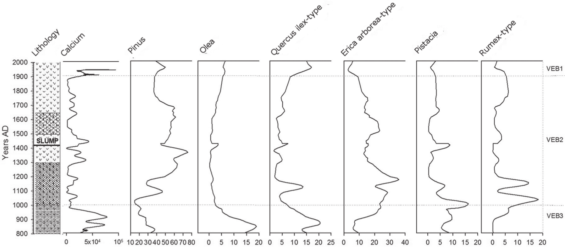
Smoothed curves of sediment calcium content, important pollen types, and lithology. Dotted lines show significant pollen zones. High calcium values correspond to drier intervals, low values to moister intervals.
Interpretation and discussion
Sedimentology and climate
The Lago di Venere sediment varies between light carbonate lamina and darker intervals dominated by detrital influx and rather higher organic content. These variations are well expressed in the Calcium (Ca) curve from the XRF measurements (Figure 6). The water analysis of several studies (Aiuppa et al., 2007; Cangemi et al., 2010; Duchi et al., 1994) documented a supersaturation of aragonite in the water column. Analysis of short sediment cores confirmed that aragonite is also very abundant in the surface sediments (Aiuppa et al., 2007). Therefore, it is likely that during dry intervals, a reduced lake volume increases the ionic concentration of the lake water favouring the precipitation of aragonite. In contrast, during wetter climatic phases more detrital input from the volcanic catchment is washed in, diluting the sedimentary carbonate content. Thus we interpret high Ca values as indicating drier intervals, and low Ca values as indicating wetter intervals (Figure 6). On this basis, our results record a dry interval from 800 to 1000 cal. yr
Vegetation history and climate
Broadleaved evergreen trees (Q. ilex, Olea) dominated the vegetation of the island forming forests from 800 to 1000 cal. yr
An important, statistically significant, change of vegetation (boundary LPAZ 1/2) occurred about 1000 cal. yr
A link between Pinus expansion at 1000 cal. yr
Although lake sediment climate records from elsewhere in Italy lack the stratigraphic resolution needed to provide a detailed climate history from the last millennium (Luterbacher et al., 2012), our pollen and sedimentological data showing a shift from a dry MWP to a moist LIA is consistent with other evidence from the central and western Mediterranean. For example, surface temperatures near Southern Italy in Gulf of Taranto declined after 1000 cal. yr
The last 100 years from 1900 to 2008 cal. yr
Vegetation history and human impact
Vegetational changes at Pantelleria were co-determined by agriculture and land use. Owing to its position in the middle of the Strait of Sicily, the island has been for millennia an important trade centre in the Mediterranean area. Despite chronological uncertainties, it has been hypothesized that the island was already frequented by 5900
Various indicators of human land use are recorded in the Lago di Venere sedimentary sequence. Grazing indicators including Anthemis-type, Cichorioideae, Aster-type, Brassicaceae, Artemisia-type, Caryophyllaceae, Carduus, as well as dung spores such as Cercophora, Podospora and Sporormiella, are distributed along the sequence and signal the continuous presence of humans on the island. Plantago lanceolata, Cerealia-type, and Mercurialis annua, suggest high levels of arable farming during the 20th century (c. 1900–1970, Figure 5). Of special interest is the strong increase of herbs (>40%) during the period between c. 950 and 1100 cal. yr
Island fire history
Changes in charcoal frequency suggest variable fire activity. In general fire activity was higher during the LIA (peaks from 1350 to 1650 cal. yr
After repeated fire disturbance Mediterranean ecosystems can undergo regressive succession towards a Cistus-dominated garrigue with Pteridium aquilinum (Chiappini, 1985; Rühl, 2003). For example, after burning, Juniperus communities are often replaced by Cistus creticus, C. salvifolius and C. monspeliensis (Gianguzzi, 1999). These shrubs and ferns are well recorded, especially Cistus which replaced Juniperus at around 1100 cal. yr
Wood was constantly cut on Pantelleria to obtain timber, charcoal and firewood from the Norman period onward (11th century
Conclusions
Our new combined record of vegetation and climate from Pantelleria Island demonstrates that small changes in moisture availability during the last 1200 years had a major impact on vegetation dynamics in a coastal Mediterranean ecosystem that was also strongly impacted by human land use. Low moisture availability before 1000 cal. yr
Footnotes
Acknowledgements
We are grateful to W Tanner, F Policarpo and P Miceli for logistical and practical help during the field work. We thank also the regional forest service (Azienda Regionale Foreste Demaniali) for providing permission to core the lake.
Funding
The Swiss National Science Foundation (grant PP00P2-114886) funded this research.