
Abstract
Our pollen-based climate reconstruction shows that both temperature and moisture were low during the early Holocene from ~10,000 to ~8000 cal. a BP and gradually climbed from ~8000 to ~6000 cal. a BP. The last ~6000 years have been generally warm and wet with high-amplitude fluctuations. The high-moisture conditions for the past ~6000 years are not only corroborated by high arboreal pollen/non-arboreal (AP/NAP; trees and shrubs over herbs) pollen ratio and high pollen concentration but also by high organic matter content and diatom data. We suggest that lower winter insolation and remaining ice covers in the early Holocene might have slowed down temperature rise in the continental interiors and that the resulted low temperature might have suppressed regional evaporation that was a major water vapor source for precipitation. At the same time, icemelt-water injection into the North Atlantic Ocean might have also suppressed water vapor supplies to the downwind areas, including the northern Mongolian Plateau. The increase in winter insolation and the final melting of ice sheets, together with the increased atmospheric CO2 concentration and the associated increase in atmospheric water vapor, could be responsible for the higher temperature during the past ~6000 years. The icemelting and the associated rise of sea level during the past ~6000 years might be responsible for the weakening of the winter monsoon in the interior of Asian continent, thus alluring farther eastward penetration of the relatively warm and wet Atlantic air masses and consequently bringing more precipitation to the northern Mongolian Plateau.
Introduction
Future environmental changes, including the changes in water resources and ecological systems, in response to future global warming in the northern Mongolian Plateau may be assessed if the driving forces of climate change at present and in the past are identified. The Holocene is of particular relevance because similar natural boundary conditions might exist in the future (Wanner et al., 2008). Generally speaking, the Holocene climate change should have been driven by four major forcing factors: (1) winter insolation, (2) summer insolation, (3) atmospheric CO2 concentration, and (4) ice cover extent. In addition, the combined effect of lower winter insolation and larger ice cover (including larger and longer snow covers and larger permafrost extents) in the early Holocene may have acted as a strong high-latitude force influencing the northern Mongolian Plateau, while after ~7000 yr BP, the combined effect of increased atmospheric CO2 concentration (Bush, 2005) and moderate summer insolation under warmed ocean surface and lessened ice cover conditions, when ‘modern’ level of atmospheric CO2 concentration and ‘modern’ ice extent were approaching (Ruddiman, 2008), may have acted as a strong low-latitude force influencing the northern Mongolian Plateau. Furthermore, a climatic feedback mechanism of combined effect of CO2 and water vapor was proposed by Bush (2005) and corroborated by Prokopenko et al. (2007) to explain the mid- and late Holocene warming observed in southern Siberia.
The Holocene climate in the northern Mongolian Plateau, where our study site (i.e. Gun Nuur) is situated, was earlier proposed to have been associated with the East Asian monsoon (Harrison et al., 1996; Tarasov et al., 2000). The Westerlies system was recently advocated as a dominating climatic system controlling the entire Asian arid–semi-arid belt, including the northern Mongolian Plateau during the entire Holocene (Chen et al., 2008). A third proposition stated that the Holocene moisture variations in the arid and hyper-arid east-central Asia, including the northern Mongolian Plateau, have been primarily modulated by the temperature (Wang et al., 2011; Wang and Feng, 2013). These disagreements call for more high-resolution paleoclimatic reconstructions from the northern Mongolian Plateau.
This paper is the fourth report on Gun Nuur to fully explore the climatic history based on 49 radiocarbon dates and 372 fossil pollen samples of GN-02 core collected in 2002 (i.e. core-A in Figure 1). The first one was by Dorofeyuk and Tarasov (1998) who provided a useful Holocene climatic framework based on limited dates and relatively low-resolution proxy data (i.e. core-C in Figure 1). The second one was by Feng et al. (2005) who reported their non-pollen data of GN-02 core drilled in 2002. The third one was by Zhang et al. (2012) who explored the Holocene histories of the lake-level and salinity changes based on proxies from carbonate materials (e.g. mineralogical and isotopic compositions) of GN-04 core drilled in 2004 (i.e. core-B in Figure 1).

Location and isobath map of Gun Nuur.
The objective of this paper was to explore the climatic history based on pollen data. First, we argued that Scots pine (Pinus sylvestris), an overwhelmingly predominant pollen type in the Gun Nuur record, reflects high-moisture conditions in our record in particular (i.e. Gun Nuur) and also reflects higher temperature conditions in all cases from the Ulaanbaatar-Baikal corridor in general (see details in section ‘Reconstructions of temperature and moisture indices’). Second, we devised a new set of temperature index (T) and moisture index (M) in which Scots pine (P. sylvestris) is a warm and wet component (Table 1). The logic to devise the new indices is the same as that used by Demske et al. (2005). That is, the relative changes in major vegetation types can be expressed by assigning recorded pollen taxa to groups corresponding to the modern distribution of plant communities.
Pollen-group subsums used for the calculation of vegetation-based temperature and moisture indices that are newly devised (in this paper).

Physiographic setting and methods
Gun Nuur (latitude 50°15′N, longitude 106°37′E, elevation 600 m a.s.l.), presently a closed lake in the middle portion of Buryn River, which is the eastern tributary of the Orkhon River, is situated within the forest-steppe zone in the middle of the Ulaanbaatar-Baikal corridor (48–56°N and 104–108°E) of the northern Mongolian Plateau (Figure 1). The maximum water depth is ~5 m, and the lake covers an area of 2.5 km2. The lower reach of the eastern tributary of the Orkhon River is covered by steppe vegetation, while the upper reach is covered by forest-steppe vegetation dominated by Scots pine (P. sylvestris) trees on the sunny edges of montane forests (Dulamsuren et al., 2009). The alluvial plain around the lake is covered by low-lying sand dunes where P. sylvestris trees dominate the landscape (Dorofeyuk and Tarasov, 1998). The modern climate of the study area is temperate continental with cold and dry winters and warm and humid summers. The mean annual temperature is about −2°C with the mean annual precipitation of about 350 mm occurring mostly from July to September (Zhang et al., 2012).
A 745-cm-long lake core (i.e. core GN-02) was collected with a Livingstone-type piston corer in 2002 at the central part of the Gun Nuur, where the water depth was about 5 m. The core was cut longitudinally into two halves and subsampled by slicing of 2-cm-thick sediment sections immediately after core retrieval in the field. For pollen analysis of 372 samples, exotic Lycopodium tablets were first added for calculation of pollen concentration, and the samples were then treated with HCl (10%) and HF (39%). More than 300 pollen grains (excluding spores) were counted and identified for each sample. Pollen identification was aided by the published references (e.g. Moore et al., 1991; Wang et al., 1995) and also with our own reference collections of more than 500 plant species from northern China. Pollen counting was carried out using a Leica light microscope under 400× magnification. Raw pollen data were expressed as percentages of the sum of terrestrial pollen.
Results
Stratigraphy and chronology
The core can be stratigraphically divided into four major units (Figure 2). Sediment Unit A (745–720 cm) is dark fine-grained sand with extremely low total organic carbon (TOC) and CaCO3 contents. Sediment Unit B (720–570 cm) is a silty and light-brown carbonate-enriched varve-like layer. Sediment Unit C (570–240 cm) is a sand–silt alternating unit containing three couplets. The silty subunits are characterized by relatively high TOC and CaCO3 contents. Sediment Unit D (240–0 cm) is a sandy silt unit with a mollusks-rich layer at the depth of 205–234 cm. This unit has the highest TOC content of the entire sequence and also a relatively high CaCO3 content.
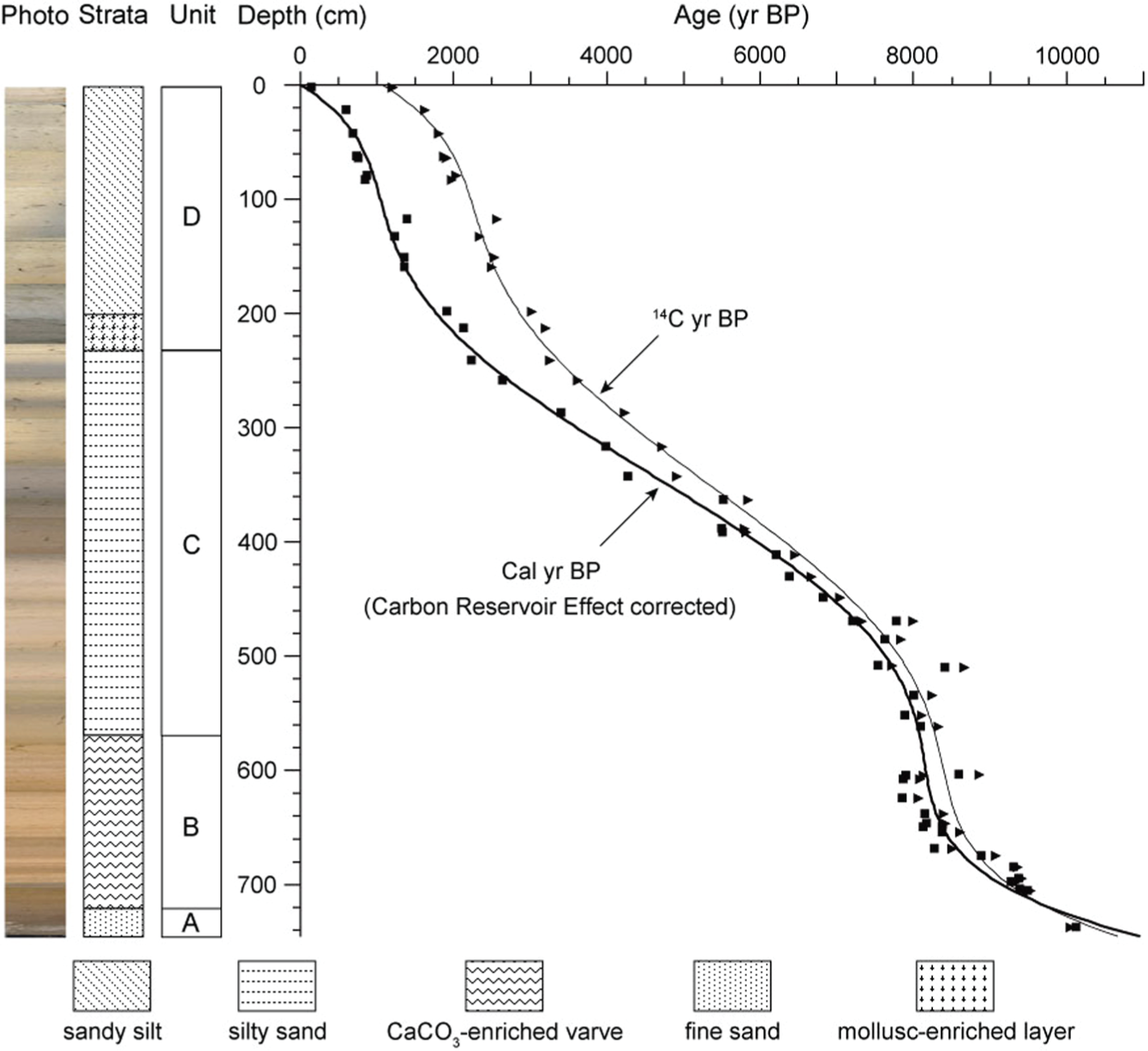
Age–depth model of GN-02 core.
A total of 49 AMS 14C dates were obtained from core GN-02. A total of 48 AMS samples were bulk sediments, and one sample was wood. The dating reliability and possible problems were fully discussed in Chang et al. (2011), and the dates were presented in Zhang et al. (2012; see supplementary Table 1). The chronology was established through the following procedures. All 48 dates of bulk sediment samples were used to establish the age–depth model after reservoir corrections following the procedure below. A fifth-order polynomial regression was used to establish the age–depth relationship (Figure 2). The intercept of the regression curve at 0-cm core depth of 1060 a BP was regarded as present-day lake-reservoir effect. The uppermost dating sample from 5 to 0 cm core depth yielded an age of 1200 ± 40 a BP. Considering that this sample integrates the uppermost 5 cm of the core sediment, the obtained radiocarbon date (1200 ± 40 a BP) corresponds reasonably well with the model-determined age for the core top (1060 a BP). Furthermore, the 1000-year difference between the wood-derived radiocarbon age from the core base (744–743 cm) and the age-model inferred age at the same stratigraphic level indicates that the lake-reservoir effect for the lowermost sediments was similar to that for the uppermost sediments. Assuming that the lake-reservoir effect varied insignificantly between the base and top of core GN-02, 1060 years were subtracted from the bulk sediment dates to account for the lake-reservoir effect. The resulting lake-reservoir corrected radiocarbon years were then calibrated using 2σ probability ranges in CALIB 6.0 and IntCal 09 (Reimer et al., 2009).
Pollen assemblages
The cluster analysis yielded four major pollen zones that are approximately correspondent with the aforementioned sediment units (Figure 3).
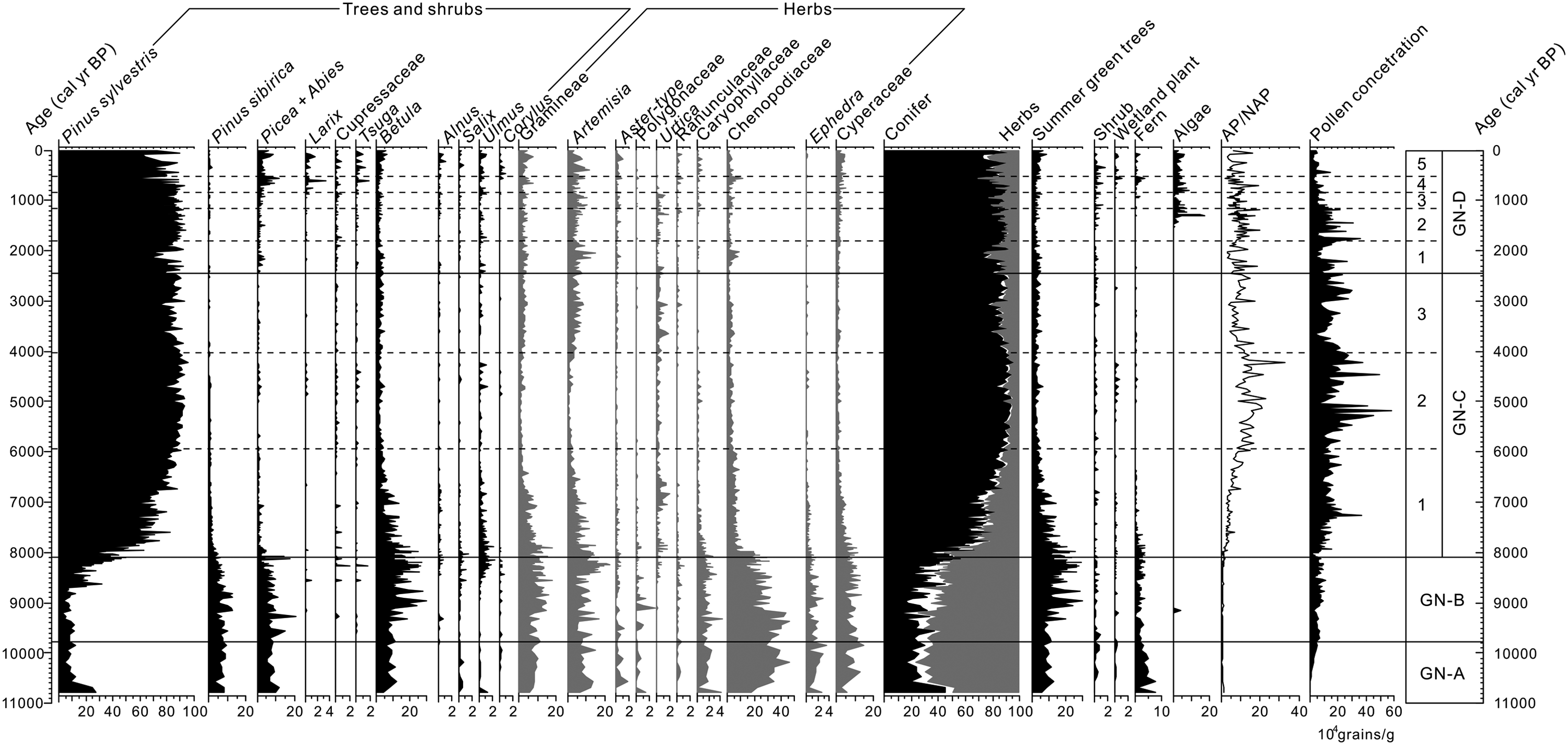
Pollen spectrum of GN-02 core.
Pollen Zone GN-A (745–720 cm; ~10,800–9800 cal. a BP) is characterized by the dominance of herbaceous pollen (~65%) with a relatively high percentage of summer-green tree pollen (~15%). The major herbaceous pollen types include Chenopodiaceae (~30%), Artemisia (~20%), and Gramineae (~10%) with some amounts of Ephedra, Aster, and Caryophyllaceae. The summer-green tree component mainly consists of Betula and Ulmus. The rest (~20%) is coniferous tree pollen (Larix, Picea, Abies, Pinus sibirica, and P. sylvestris). It is also noticeable that percentages of Cyperaceae and fern are quite high in this zone.
Pollen Zone GN-B (720–570 cm; 9800–8100 cal. a BP) is distinctive from GN-A by an increased Betula percentage and decreased Chenopodiaceae and Ephedra percentages. But the commonalities between Zone GN-A and Zone GN-B are more pronounced than their differences, and the major commonalities include rather visible appearance of Larix, P. sibirica, Picea, and Abies and constantly high percentages of Artemisia and Gramineae.
Pollen Zone GN-C (570–240 cm; 8100–2400 cal. a BP) is typified by a persistently high percentage of P. sylvestris accompanied with significant reduction in herbaceous components (mainly including Chenopodiaceae, Artemisia, Gramineae, and Cyperaceae). Other noticeable features of GN-C include nearly complete disappearance of Larix, P. sibirica, Picea, and Abies and dramatic increases in arboreal pollen/non-arboreal pollen (AP/NAP) ratio and in pollen concentration. The fluctuations in the percentages of arboreal components and herbaceous components further divide the Zone GN-C into three subzones.
Pollen Zone GN-D (240–0 cm; 2400–0 cal. a BP) is also dominated by P. sibirica pollen. But the most pronounced features are as follows: (1) reappearance of some coniferous tress (e.g. Larix, P. sibirica, Picea, and Abies), (2) reappearance of some summer-green trees (e.g. Corylus, Betula, and Ulmus), (3) appearance of Tsuga and Cupressaceae, and (4) recovery of some major herbaceous components (e.g. Chenopodiaceae, Artemisia, Aster, Gramineae, and Cyperaceae). Variations in P. sibirica and Artemisia percentages further divide this zone into five subzones.
Discussion and conclusion
Reconstructions of temperature and moisture indices
We first tested two different sets of already-published pollen-based climatic indices to explore their applicability to our record. The first set of temperature (T) and moisture (M) indices (see supplementary Table 2) was constructed by Demske et al. (2005) based on the observed relationships between modern plant distribution and associated climate in southern Siberia. The second set of T and M indices (see supplementary Table 3) was constructed by Ma et al. (2008) based on a surface-soil pollen data base generated along an S-N transect in the Mongolian Plateau. The reconstructed T using the index defined by Demske et al. (2005) shows that the temperature was rather low from ~11,000 to ~7000 cal. a BP and has been variably warm during the past ~7000 years (Figure 4A). The reconstructed M suggests that the wettest period lasted from ~11,000 to ~8000 cal. a BP that was followed by a drying trend lasting from ~8000 to ~6000 cal. a BP. After a persistent dry period between ~6000 and ~2500 cal. a BP, the moisture has been recovering for the past ~2500 years. The reconstructed T using the index defined by Ma et al. (2008) shows that the temperature was rather high from ~11,000 to ~8000 cal. a BP and has been constantly low during the past ~8000 years (Figure 4B). The reconstructed M suggests that the moisture was rather low from ~11,000 to ~8000 cal. a BP and has been relatively and variably high during the past ~6000 years after a 2000-year transition (from 8000 to 6000 cal. a BP). It is rather apparent that the reconstructed T and M curves using indices by Demske et al. (2005) are completely opposite to those using indices by Ma et al. (2008).
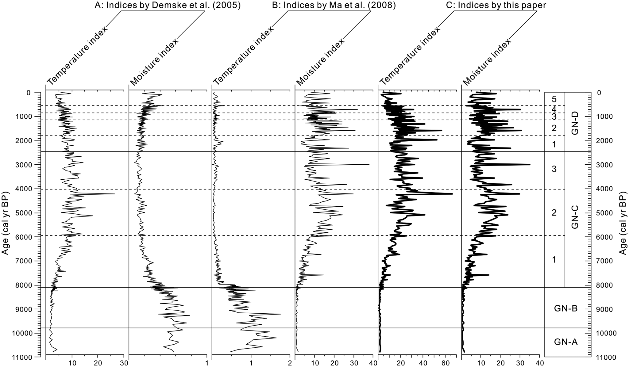
Reconstructions of pollen-based temperature in indices (T) and moisture indices (M) for Gun Nuur lake core (A by Demske et al. (2005), B by Ma et al. (2008), and C from this paper).
The opposite trends between these two sets of reconstructions resulted from two absolutely opposite angles from which the predominant pollen species, Scots pine (P. sylvestris), was bioclimatologically categorized. Specifically, Demske et al. (2005) developed their T and M indices in southern Siberia where the southward increasing trend of Scots pine abundance represents warming and drying trends along the modern bioclimatic N→S transect. In contrast, Ma et al. (2008) developed their T and M indices based on their own data set from the entire Mongolian Plateau where climate becomes cooler and wetter along the modern bioclimatic S→N transect. The observed gradual increase in Scots pine trees and the associated northward increase in Scots pine pollen percentage in the northern portion (i.e. cooler and wetter portion) of the Mongolian Plateau defined the Scots pine as a cooler and wetter component in the indices by Ma et al. (2008).
Scots pine (P. sylvestris) is a eurythermic species native to Europe and Asia, which also adapts to a wide range of precipitation conditions. Longitudinally, its distribution ranges from Ireland in the west to eastern Siberia in the east. Latitudinally, its distribution ranges from Inner Mongolia of China to Arctic Circle in Asia (Zhang, 2007). In the mountain ridges within Lake Baikal region, Scots pine (P. sylvestris) and larch (Larix) taiga prevails on drier/warmer south- and east-facing slopes and at drier/warmer lower elevations, while Siberian pine (P. sibirica), fir (Abies), and spruce (Picea obovata) taiga are widespread on wetter/cooler north- and west-facing slopes and at wetter/cooler higher elevations. Consequently, Scots pine has been regarded as a dry and warm component for reconstructing Holocene climate change in Lake Baikal area (i.e. Bezrukova et al., 2009, 2011; Demske et al., 2005; Tarasov et al., 2005, 2007, 2009). Our focal site (i.e. Gun Nuur) is situated in the middle portion of Buryn River basin, an eastern tributary of the Orkhon River, the latter (i.e. Orkhon) being a branch of the Selenga River that directly flows into Lake Baikal. Within the Selenga River basin, Scots pine trees absolutely dominate the sunny edges of montane forests (Dulamsuren et al., 2009). The alluvial plain around Gun Nuur is covered by low-lying sand dunes where Scots pine trees also dominate the landscape (Dorofeyuk and Tarasov, 1998). The domination of Scots pine at the sunny edges of montane forests in the northern Mongolian Plateau gives rise to the assumption that it is a rather drought-tolerant species, and the assumption was field confirmed within the forest-steppe ecotone in the northern Mongolian Plateau (Dulamsuren et al., 2009).
It is true that Scots pine is a rather drought-tolerant species compared with many other tree species in the Ulaanbaatar-Baikal corridor. But the situation is completely different between the Lake Baikal area in the center of the Siberian Taiga forest in the north and the Gun Nuur area in the middle of a forest-steppe zone in the south. Scots pine will definitely take over the place of dark coniferous trees (e.g. Siberian pine, fir, and spruce) in the Lake Baikal area if the soil moisture is sufficiently lowered. However, Scots pine will definitely give way to herbaceous species in the Gun Nuur area if the soil moisture is sufficiently lowered. In other words, its growth does have a minimal requirement for soil moisture and thus actually is a wet-indicative species in comparison with major herbaceous species in steppes and forests-steppe (Dulamsuren et al., 2009; Zhang, 2007). Assuming that the Gun Nuur area has been primarily within forest-steppe zone during the entire Holocene, the limiting factor for Scots pine to expand should be the soil effective moisture. This assumption is in fact supported by the pollen data showing that the Scots pine–dominated vegetation (rather than dark coniferous trees-dominated) has been dominating the landscape during the past ~7000 years (see Figure 3). Therefore, we argue here that Scots pine should be a higher moisture component in our case (i.e. Gun Nuur).
Scots pine has been regarded as a higher temperature component in paleoclimate reconstructions of southern Siberia, including the Lake Baikal area (e.g. Bezrukova et al., 2009; Demske et al., 2005; Prokopenko et al., 2007; Tarasov et al., 1997, 2007, 2009), and the logic is simply derived from modern bioclimatic background of Scots pine growth in southern Siberia in general and in the Lake Baikal area in particular. Here, we present three sets of arguments supporting the proposition. Temporally, nearly all of Lateglacial and Holocene pollen sequences obtained from the southern boundary of the Siberian taiga forests ubiquitously show that Lateglacial steppe vegetation was gradually replaced by Scots pine–dominated forests during the early Holocene, suggesting that the expansion of Scots pine trees most likely resulted from postglacial warming (e.g. Blyakharchuk et al., 2004, 2007; Kremenetski et al., 1997; Rudaya et al., 2009; Tarasov et al., 1997, 2000). Latitudinally, two pieces of evidence support the notion that Scots pine is associated with high temperature. First, the pollen-indicated progressive and northward Holocene expansion of Scots pine trees from the northern Mongolian Plateau, through the Lake Baikal area, to central Siberia during the early Holocene implies that northward retreating of permafrost and the associated northward soil warming along the S→N transect were most likely the reasons behind the northward expansion of Scots pine trees (e.g. Bezrukova et al., 2009, 2011; Demske et al., 2005; MacDonald et al., 2000; Prokopenko et al., 2007; Tarasov et al., 2000). Second, the present abundance of Scots pine trees is definitely increasing along the N→S warming transect from central Siberia, through the Lake Baikal area, to the northern Mongolian Plateau. Topographically and attitudinally, Scots pine (P. sylvestris), together with larch (Larix), prevails on warmer south- and east-facing slopes and at warmer lower elevations in Lake Baikal area (Demske et al., 2005; Prokopenko et al., 2007; Tarasov et al., 2000). We also want to add that the low-temperature notion of Scots pine by Ma et al. (2008) is not statistically robust simply because only 10 sampling points of total 108 samples were from the Scots pine–present landscapes (forests and forests-steppe), and the 10 sampling points were from a relatively small area around the Lake Hovsgol at the northern tip of the Mongolian Plateau.
As argued above, Scots pine is a higher moisture component in Gun Nuur area in particular and a higher temperature component in all cases from the Ulaanbaatar-Baikal corridor in general. We have thus devised a new set of temperature index (T) and moisture index (M) to accommodate above arguments. The reconstructions based on the newly devised indices (Table 1) show that both T and M were low during the early Holocene between ~10,000 and ~8000 cal. a BP and gradually climbing in the following period between ~8000 and ~6000 cal. a BP. The last ~6000 years have been generally warm and wet with the recent millennium being slightly cooling (Figure 4C).
It is rather notable that the pollen-based reconstruction of high moisture for the past ~6000 years is well corroborated by AP/NAP ratio and also by pollen concentration (Figure 5). The organic matter content, an indicator of primary productivity in the watershed and in the lake (Shen et al., 2010), also lends a strong support to the reconstruction. Another set of supportive evidence comes from diatom abundance (Figure 5). Specifically, higher abundance of planktonic diatom from GN-02 core, as an indicator of a deeper lake (Dorofeyuk and Tarasov, 1998; Shen et al., 2010), corresponds with higher moisture index for the period between ~6500 and ~1500 cal. a BP. Higher abundance of benthic diatom, as an indicator of a shallower lake, approximately corresponds with lower moisture index for the period between ~9000 and ~7000 cal. a BP and also for the period between ~1500 and ~500 cal. a BP. It is notable that two samples within the unit of dark fine-grained sand (i.e. GN-A) have a very high abundance of planktonic diatom, and the eolian or fluvial nature of the sand (see Dorofeyuk and Tarasov, 1998; Zhang et al., 2012) suggests that the diatom may be of exotic origin. Furthermore, the well-expressed coexistence of Cyperaceae with Chenopodiaceae and Ephedra in the early Holocene between ~11,000 and ~8000 cal. a BP suggests that the lake was rather shallow and wetland components (e.g. Cyperaceae) were abundant around the lake (see Figure 3). And, the lack of Cyperaceae between ~6500 and ~2000 cal. a BP may also indicate that the lake was indeed deeper compared with that during the preceding ~11,000 and ~6500 cal. a BP) and the succeeding periods (~2000 and ~0 cal. a BP). It should be added that increased abundance of Cyperaceae in semi-arid and subhumid conditions, especially when highland contribution of Cyperaceae is negligible, was widely reported to be associated with lake shoaling and the associated increase in wetland areal extent (Shen et al., 2010; Wang et al., 2011). It should be noted that a grain-size peak at 3900–3500 cal. a BP was interpreted to represent shallower lake conditions (Zhang et al., 2012) and this interpretation is corroborated by a lower organic matter content and also by a slightly lowered moisture index. Overall, the reconstructed moisture index (newly devised) seems to be supported by other data and the reconstruction is thus trustworthy. It should be particularly mentioned that the extremely low pyrite content between 280 and 450 cm of GN-04 core was interpreted to have documented a dry mid-Holocene between ~6000 and ~2500 cal. a BP (see Zhang et al., 2012). However, pyrite as a proxy for marine organic matter decomposition (Berner, 1984, 1985) needs further investigations into its climatic and hydrological meanings in lake settings.
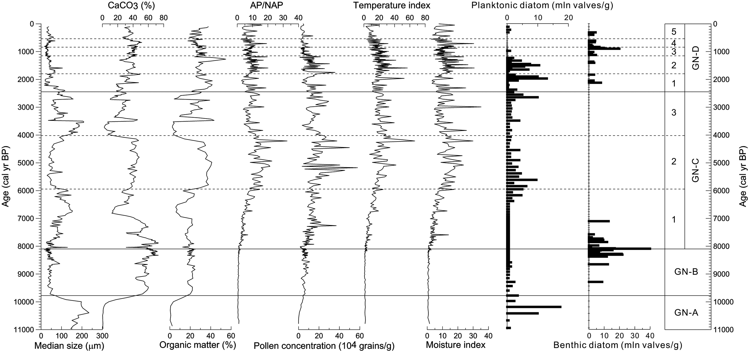
The reconstructions of newly devised T and M indices are supported by organic matter content, pollen AP/NAP ratio, pollen concentration, abundance of planktonic diatom, and abundance of benthic diatom (note: following data are from GN-04 core: grain-size, carbonate and organic matter contents; see Zhang et al. (2012)).
Regional comparison
In order to look into our record of Gun Nuur from a larger geographic perspective, we will review some recently published Holocene records from surrounding areas. The first area to be reviewed is the Altai Mountains in the western margin of the northern Mongolian Plateau where many lakes (including Uvs Nuur and Hoton Nuur labeled in Figure 1) have been intensively studied. According to their recent reconstruction from Hoton Nuur and also to their reviews of other’s works (including Blyakharchuk et al., 2004, 2007; Dorofeyuk and Tarasov, 1998; Grunert et al., 2000; Tarasov et al., 2000), Rudaya et al. (2009) concluded that in the eastern Altai area within Mongolia, the first half of the Holocene (from ~11,000 to ~5000 cal. a BP) was warm and wet and the second half (from ~5000 to ~0 cal. a BP) was cool and dry, being consistent with the East Asian monsoon-dominated climate pattern. In the western Altai area within Kazakhstan, the first half of the Holocene was warm and dry and the second half was cool and wet, being consistent with the Westerlies-dominated climate pattern. In the northern Altai area within Russia, the first half of the Holocene was warm and wet and the second half was cool and wet.
In the eastern margin of the northern Mongolian Plateau, a recently reported Holocene climatic reconstruction from Lake Hulun within Northeast China (Wen et al., 2010a, 2010b; see Figure 1 for location) shows that the early Holocene before ~8000 cal. a BP was warm and dry and the mid-Holocene between ~8000 and ~4500 cal. a BP was the wettest period of the entire Holocene under a slightly cooling condition. After a pronounced dry and relatively cool interval between ~4500 and ~3500 cal. a BP, the climate was generally warm and wet between ~3500 and ~1000 cal. a BP. The first half of the last millennium was cool and dry and the second half warm and wet. The Holocene reconstruction from Lake Hulun is corroborated by the peat δ13C record from nearby Hani Peat (Hong et al., 2005).
To the south of Gun Nuur are Ugii Nuur and Lake Telmen (see Figure 1 for locations) where a mid-Holocene dry phase was reported to have lasted from ~6500 to ~3500 cal. a BP (Fowell et al., 2003; Peck et al., 2002; Wang et al., 2009, 2011). The preceding period before ~6500 cal. a BP and the succeeding period after ~3500 cal. a BP were relatively wet. This mid-Holocene dry phase was approximately corresponding with the warm mid-Holocene in southern Siberia to the north (Demske et al., 2005) and with the warm mid-Holocene in northern China to the south (Shi et al., 1993), implying that the mid-Holocene dry phase in the arid and semi-arid portions of the Mongolian Plateau was most likely the result of mid-Holocene high temperature (Wang et al., 2011; Wang and Feng, 2013).
To the north of Gun Nuur is Lake Baikal basin where lake cores and peatland sections have been intensively studied (e.g. Bezrukova et al., 2009, 2011; Demske et al., 2005; Fukumoto et al., 2012; Horiuchi et al., 2000; Prokopenko et al., 1999, 2007; Prokopenko and Williams, 2004; Shichi et al., 2009; Tarasov et al., 2005, 2007, 2009). The reconstructions show that birch and spruce-mixed forests and shrubs replaced wormwood steppe during the early Holocene and Scots pine open forests became dominant vegetation since ~7000 cal. a BP (Demske et al., 2005). However, inconsistencies among the reconstructions are readily visible. For example, three semi-quantitative reconstructions display approximately the same trends of temperature and moisture variations (Demske et al., 2005). That is, an increasing trend of the temperature index and a decreasing trend of the moisture index characterize the early Holocene (before ~6000 cal. a BP). The moisture index had a slight increasing trend, and the temperature index had a relatively steep declining trend after ~6000 cal. a BP. However, a quantitative reconstruction seems to tell a different story (Tarasov et al., 2007). The reconstructed annual precipitation and winter temperature have parallel trends, and both exhibit three stages of variations. The first stage was warming and wetting from ~11,000 to ~8000 cal. a BP, the second stage cooling and drying from ~8000 to ~6000 cal. a BP, and the third stage again warming and wetting during the past ~6000 years.
As stated earlier, the reconstructions of pollen-based temperature and moisture histories using the newly devised indices (see Table 1) show that both temperature and moisture were low during the early Holocene between ~10,000 and ~8000 cal. a BP and gradually climbed in the following period between ~8000 and ~6000 cal. a BP. The last ~6000 years have been generally warm and wet with high-amplitude fluctuations. The reconstructed moisture history is not only supported by AP/NAP ratio and pollen concentration but also by organic matter content and diatom data. Our moisture reconstruction is generally in agreement with the moisture reconstructions from Baikal records, that is, a drying early Holocene from ~11,500 to ~6000 cal. a BP and a wetting late Holocene since ~6000 cal. a BP (Demske et al., 2005; Tarasov et al., 2007). Our moisture reconstruction is also broadly in agreement with the moisture reconstructions from the Westerlies-dominated western Altai records, that is, a drying early Holocene from ~11,500 to ~5000 cal. a BP and a wetting late Holocene since ~5000 cal. a BP (Rudaya et al., 2009). The well-expressed second wet period lasting from ~3500 to ~1000 cal. a BP at Lake Hulun (Wen et al., 2010b) may also be a compressed correspondence to the late Holocene wetting retrieved from Gun Nuur.
Nevertheless, a cold early Holocene before ~6000 cal. a BP and a warm late Holocene after ~6000 cal. a BP retrieved from Gun Nuur are not geographically coherent with the above-reviewed reconstructions (Demske et al., 2005; Rudaya et al., 2009; Tarasov et al., 2007, 2009). The reviewed reconstructions nearly unanimously exhibit a warming early Holocene and a cooling late Holocene. However, the Holocene Thermal Maximum in the records from Lake Baikal was earlier noted to have occurred between ~6500 and 2500 cal. a BP (Demske et al., 2005), supporting our reconstruction at Gun Nuur. It should also be noted that a quantitative reconstruction from Lake Baikal (Tarasov et al., 2007) does show that the past ~6000 years have been gradually warming and slightly wetting after a cooling and drying stage from ~8000 to ~6000 cal. a BP. Furthermore, a synthetic study, through constraining the carbon reservoir corrections in Baikal chronologies and re-debating the climatic meanings of proxy data, shows an increase in both winter and summer temperatures after ~7000 cal. a BP (Prokopenko et al., 2007), being consistent with our temperature reconstruction from Gun Nuur.
Underlying mechanisms of regional climate change
If our reconstruction from Gun Nuur and the synthetic study from Lake Baikal (Prokopenko et al., 2007) can stand for further tests, the reconstructed cold and dry early Holocene from ~11,000 to ~6000 cal. a BP and warm and wet late Holocene (i.e. past ~6000 years) may be attributable to two factors: (1) combined effect of lower winter insolation and larger ice covers in the early Holocene (Climate: Long-range Investigation, Mapping, and Prediction (CLIMAP) Members, 1981; Ruddiman, 2008; Tarasov et al., 1997, 2007) and (2) combined effect of increased atmospheric CO2 concentration and moderate summer insolation under warmed ocean surface and lessened ice cover conditions after ~7000 cal. a BP (Bush, 2005; Cooperative Holocene Mapping Project (COHMAP) Members, 1988; Peltier and Fairbanks, 2006; Prokopenko et al., 2007; Ruddiman, 2008). That is, lower winter insolation and remaining ice covers (and larger and longer snowcovers and larger permafrost extents) in the early Holocene might have retarded temperature rise in the continental interiors and the resulted low temperature might have efficiently suppressed regional evaporation that has been a major water vapor sources for precipitation in southern Siberia (Lydolph, 1977) and probably also in northern Mongolian Plateau. At the same time, icemelt-water injection into the North Atlantic Ocean might have also suppressed water vapor supplies to the downwind areas, including the northern Mongolian Plateau in the early Holocene. It is not a surprise that the levels of some lakes were actually higher under early Holocene warming and dry conditions if the lakes were supplied by glacier-melting waters (Grunert et al., 2000; Zhang et al., 2012).
The increase in winter insolation and the final melting of ice covers, together with increased atmospheric CO2 concentration and the associated increase in atmospheric water vapor (Bush, 2005), could be responsible for the higher temperature during the past ~7000 years. The melting of ice covers and the associated rise of global sea level might be responsible for the weakening of the winter monsoon in the interior of Asian continent, thus alluring farther eastward penetration of the relatively warm and wet Atlantic air masses (Moros et al., 2004; Peltier and Fairbanks, 2006; Rudaya et al., 2009) and consequently bringing in more water vapor to the east-central Asia, including the northern Mongolian Plateau (Bai et al., 2010).
Concluding remark
Although we have presented three sets of arguments supporting the proposition that Scots pine represents higher temperature conditions (see section ‘Reconstructions of temperature and moisture indices’), but we do have trouble in untangling temperature signal from moisture signal. For example, the distribution of Scots pine in sunny slopes and at lower elevations in the Lake Baikal area suggests that Scots pine prefers higher temperature and lower moisture in comparison with other coniferous trees, but lower moisture primarily results from higher temperature via enhanced evaporation. Furthermore, unlike the reconstructed moisture index that is well corroborated by other proxies, the reconstructed temperature index is lack of corroboration from other proxies. Simply put, our confidence on the temperature reconstruction needs a boost from in-depth investigations of pollen–climate relationships and also from further bioclimatic understanding of Scots pine.
Footnotes
Funding
This paper is a result of projects supported by NSFC grants (No. 40930102, No: 40331012, and No: U1203821L08) and NSF grants (NSF-ESH-04-02509 and NSF-BCS06-52304).