
Abstract
A multiproxy study of a 7 m long sedimentary sequence from Lake La Parra (39°50.948′, 1°52′, 1014 m a.s.l.) supported by 11 14C AMS and 210Pb/137Cs dates provides a robust, high-resolution hydrological and environmental variability record for the last 1600 years of the Las Torcas sinkhole Complex in the Central Iberian Range. The succession of depositional environments in Lake La Parra sinkhole is controlled by both changes in the regional water table and by the balance between sedimentary input through ephemeral creeks and in-lake production of carbonates and organic matter. Although synergetic links with climate are likely, phases of increased sediment delivery to the lake at c.
Keywords
Introduction
Late Holocene palaeoclimate reconstructions are critical in improving our understanding of current climate variability and predictions of environmental responses to future climate changes (Bradley et al., 2003; Jones et al., 2009; Mann et al., 2009; Mayewski et al., 2004). Most North Hemisphere palaeoclimate records spanning the last two millennia include evidence of two main climate periods, although the timing is not yet well constrained (Mann et al., 2009): a warmer ‘Medieval Climate Anomaly’ (‘MCA’,
A number of climate reconstructions over the last two millennia for the Mediterranean region have been recently published (see Lionello, 2012; Magny et al., 2013; Moreno et al., 2012; Roberts et al., 2012; Valero-Garcés and Moreno, 2011), which describe rapid environmental and climatic changes coinciding chronologically with the ‘MCA’ and the ‘LIA’ with underlying regional trends. These trends highlight timing discrepancies in palaeohydrological shifts, with associated variability in inferences concerning the definition of age ranges for wet and dry phases. In the Iberian Peninsula, numerous Late Holocene lake sequences have been analysed in a variety of geographic, climatic and ecologic settings using a variety of geological (facies, geochemistry) and biological (pollen, ostracods, diatoms, quironomids) proxies (Corella et al., 2012; Currás et al., 2012; Höbig et al., 2012; Martín-Puertas et al., 2009; Morellón et al., 2011; Moreno et al., 2008, 2009). Diatom studies have demonstrated large environmental changes in Iberian lakes during the last 2000 years in water depth, salinity and trophic status: Laguna de Medina (Reed et al., 2001), Sanabria (Luque and Julià, 2002), Enol (López-Merino et al., 2011), La Cruz (Julià et al., 1998; Kiss et al., 2007), Arreo (Corella et al., 2011), Montcortès (Scussolini et al., 2011), Estanya (Riera et al., 2004), Estany Redon (Pla and Catalán, 2005), Zoñar (Martín-Puertas et al., 2008) and Lagoa Grande (Leira, 2005; Reed, 1998). The available records show that Iberian lake dynamics responded primarily to changes in hydrology, with relatively humid conditions coinciding with the Iberian–Roman Humid Period (IRHP, 650
Regional setting and study site
La Parra (39° 50′N, 1° 52′E, 1014 m a.s.l.) is one of the seven flooded sinkholes located in the complex karstic-lake system of Cañada del Hoyo, Central Iberian Range (Figure 1). This complex is developed by dissolution and fracture processes since the Pliocene (Gutiérrez-Elorza and Valverde, 1994) on Jurassic and Middle to Upper Cretaceous limestone and dolostone formations (Alonso, 1986). Regional tectonic structures as the Valdemoro fault and the occurrence of a NW–SE anticlinal fold have also played a significant role in the development of this karstic system (Carmona and Bitzer, 2001; Eraso et al., 1979).
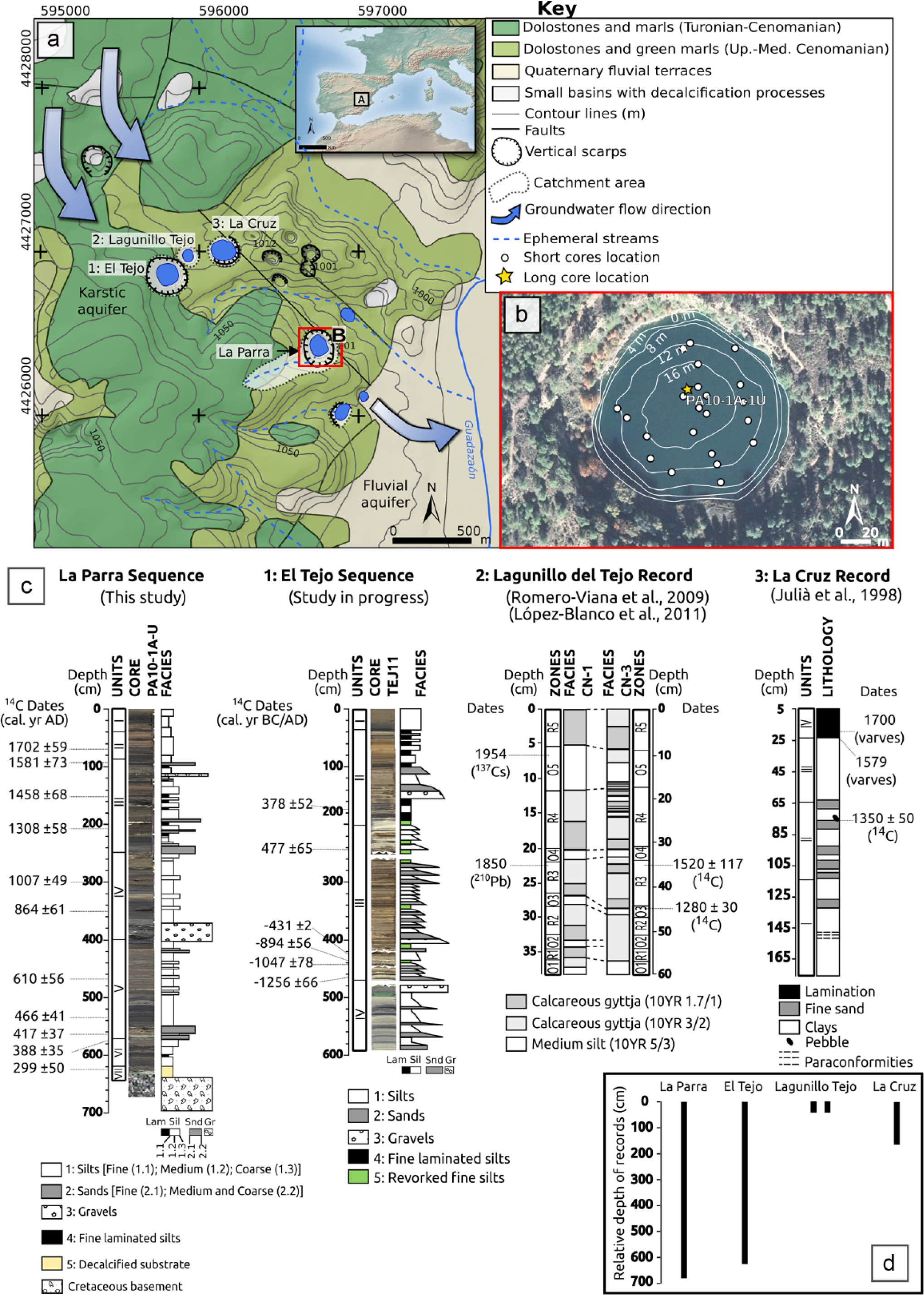
(a) Location of study site and detailed geological map of the lake complex from Cañada del Hoyo (based on IGME (1973) and IGN (2002)). (b) Lake La Parra bathymetry with short cores (white dots) and long core PA10-1A-U (yellow star) location. (c) Cores recovered up to date on the lake complex in depth with the main dates and sediment stratigraphy (1: El Tejo; 2: El Lagunillo del Tejo; 3: La Cruz). (d) Relative depth of each record.
The study site has a Mediterranean climate modulated by continental influences with large daily and seasonal temperature contrast, harsh cold winters and hot summers (from 4°C mean monthly temperature in January to 23°C in July). Annual mean rainfall is 542 mm, with July the driest month and October the wettest. Local vegetation is dominated by Pinus nigra, Quercus faginea, Quercus ilex rotundifolia, Juniperus thurifera, Buxus sempervirens and Quercus coccifera. Depressions and lowlands are occupied by cereal crops.
Lake La Parra has a circular morphology (113 m diameter, 1 ha surface) and steep margins (17.5 m maximum depth; Figure 1), with 10 m high vertical scarps composed of Upper Cretaceous dolomites surrounding the lake from W to SE. Influenced by a dolomite-rich watershed, the lake waters are dominated by HCO3− (4.78 meq/L) anions and Mg2+ (3.96 meq/L) cations, with pH of 8.
The lake is holomictic (Miracle et al., 1992) as shown by chemical (Electrical Conductivity from 305 µS/cm to 356 µS/cm at 16 m depth) and isotopic measurements (from −4.01 to −4.20 per mil δ18O, and from −38.11 to −37.46 per mil δD at surface and 16 m water depth, respectively). The lake has an ephemeral inlet and no permanent surface outlet (Carmona and Bitzer, 2001). Although no hydrological balance is available, the recent lake level fluctuations are controlled by (1) the small watershed (~ 10 ha) with reduced run-off input, (2) the low transmissivity of local and regional aquifers, (3) a high-seasonal rainfall regime with high evaporation and (4) recent use of regional aquifers by agriculture wells. The enriched δ18O values in lake water (ca −4 per mil) compared with aquifer and surface waters δ18O values (−8.5 to −7 per mil, Carmona and Bitzer, 2001) demonstrate a strong impact of evaporation processes in lake hydrology.
The lakes of Las Torcas karstic system are hydraulically connected to the regional carbonate aquifer, and the lake levels reflect the regional groundwater levels. The main aquifer-recharge area (60% total water influx) is located in a 25 km2 karstic area, located some 15 km north of the Las Torcas Complex. The groundwater flux is estimated as 300 l/s (Carmona and Bitzer, 2001) and follows N-S trend fractures and karstic conduits towards the south and only floods the sinkholes located topographically at <~1000 m a.s.l. From the sinkholes, groundwater drains towards the Guadazaón River fluvial aquifer.
Material and methods
In May 2010, two parallel piston cores (PA10-1A-U and PA10-1B-U) were recovered in the deepest part of the lake with the IPE-CSIC UWITEC platform and coring equipment. Later, in summer 2011, a network of 21 short gravity cores was retrieved with the UWITEC gravity corer. The piston cores were split longitudinally and photographed with the CCD camera attached to the AVAATECH X-Ray Fluorescence (XRF) scanner from the XRF-Core Scanner Laboratory of the University of Barcelona (UB, Spain); 52 samples were taken from the core PA10-1A-U for quantitative elemental geochemistry of major and trace elements by Inductively Coupled Plasma-Mass Spectrometry (ICP-MS), using a Perkin/Elmer Nexion 300X ICP-MS at the University of Pittsburgh (US-PA), following Pompeani et al. (2013). The same core was sub-sampled every 2 cm for Total Organic Carbon (TOC) and Total Inorganic Carbon (TIC) and every 6 cm for Total Nitrogen (TN). TIC and TOC were measured with a LECO SC144DR available at the IPE-CSIC and TN with a FLASH EA 1112 LECO TRUSPEC-CN at the Centro de Edafología y Biología Aplicada del Segura (CEBAS-CSIC, Spain). Principal Component Analysis (PCA) was carried out to investigate the relationship between the chemical elements present on the sediments. Statistical treatment of the data was performed using R software (R Development Core Team, 2013). The dataset includes major elements, trace elements and REE (determined by ICP), and also bulk geochemistry (TOC, TIC and TN). All variables were normalized with respect to their mean and standard deviation. Mineralogy was analysed every 10 cm by a Siemens D-500 x-ray diffractometer (Cu kα, 40 kV, 30 mA, graphite monocromator) at the Serveis Científico-Tècnics of the ICTJA-CSIC (Spain). Identification and relative abundance of the predominant mineralogy of the crystalline fraction were determined following Chung (1974a, 1974b).
Sedimentary facies were described following Schnurrenberger et al. (2003). Selected samples from each facies were analysed with a JEOL JSM-6400 electron microscope coupled with an EDAX INCA 300 X-Sight for elemental identification at the University of Zaragoza (Spain).
Standard extraction and counting methods (Stoermer et al., 1996) were applied to 20 samples for diatom analyses. The samples were selected considering sedimentary facies variability, and therefore, the resolution varies from 20 to about 150 years. Diatom concentration per unit weight of dry sediment was calculated following Battarbee (1986) and is expressed as valves per gram of dry sediment (v/gds × 106). Relative abundances of the diatom taxa were calculated in two ways: (1) based on the total diatom sum, which were used for the calculation of the planktonic and non-planktonic percentages, and (2) based on a partial diatom sum which included all species except for Cyclotella cyclopuncta; species percentages presented in Figure 5 were calculated in this way. This method for expressing diatom relative abundance was chosen given the high dominance of Cyclotella cyclopuncta in the record, as excluding it from the diatom sum allows for the variations along the sequence of the non-dominant species to be more evident; this explains the above 100% abundances of Cyclotella cyclopuncta in the diatom diagram. Taxonomic identifications and autoecological requirements for the principal diatom taxa were made using literature (Håkansson, 2002; Håkansson and Carter, 1990; Julià et al., 1998; Kiss et al., 2007; Krammer and Lange-Bertalot, 1986–1991; Morellón et al., 2011). The dominant species in this record was identified as Cyclotella cyclopuncta; however, this species is considered to be very close or possible conspecific with similar small centric diatoms such as Cyclotella delicatula or Cyclotella distinguenda var. unipunctata (see Kiss et al., 2007). The statistical treatment of the diatom dataset for cluster analysis was performed using the R software package (R Development Core Team, 2013) together with the package ‘vegan’ (Oksanen et al., 2013). Distances between clusters were recomputed by the Bray–Curtis method, using a data matrix corrected by the square root of the species percentages.
To establish the chronology of the lacustrine sequence, 13 AMS 14C dates were obtained at the Poznan Radiocarbon Laboratory (Poland) and the DirectAMS Laboratory (US-WA) from wood fragments in long core PA10-1A-U (Table 1) and 137Cs and 210Pb dates in short core PA-10-2A-1G were obtained by gamma ray spectrometry at the St Croix Watershed Research Station (US-MN). The 210Pb dates were determined following Appleby (2001). The upper part of core PA10-1A-U was correlated with the short core PA-10-2A-1G using TOC values (Figure 2). Radiocarbon dates were calibrated using the curve IntCal09 (Reimer et al., 2009) and selecting the median of the 95.4% distribution (2σ probability interval). Age–depth model was performed with Clam code (Blaauw, 2010), adjusting the curve with a locally weighted spline.
Radiocarbon dates used for the construction of the age model for the Lake La Parra sequence. Dates were calibrated using CLAM software ( Blaauw, 2010 ) and the IntCal09 curve (Reimer et al., 2009), and the 2σ probability interval was selected.
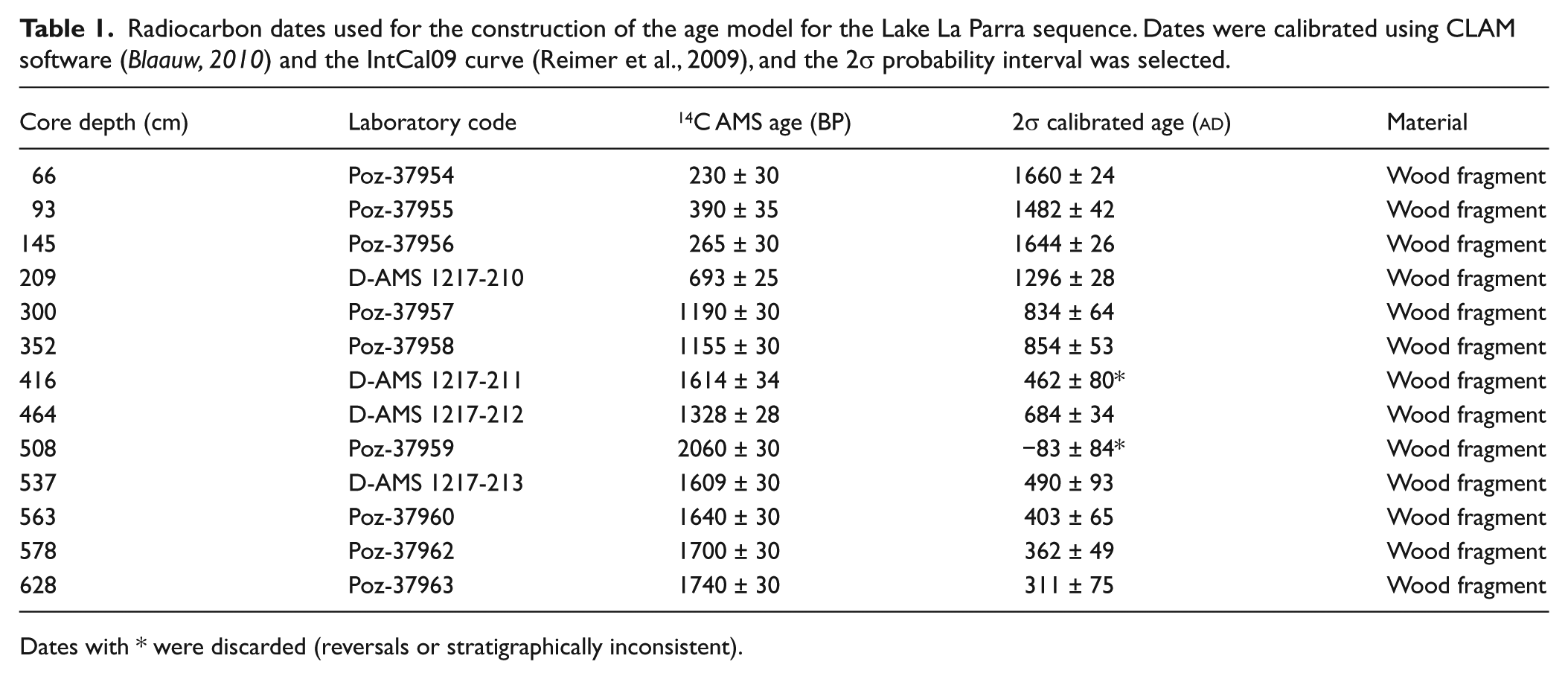
Dates with * were discarded (reversals or stratigraphically inconsistent).
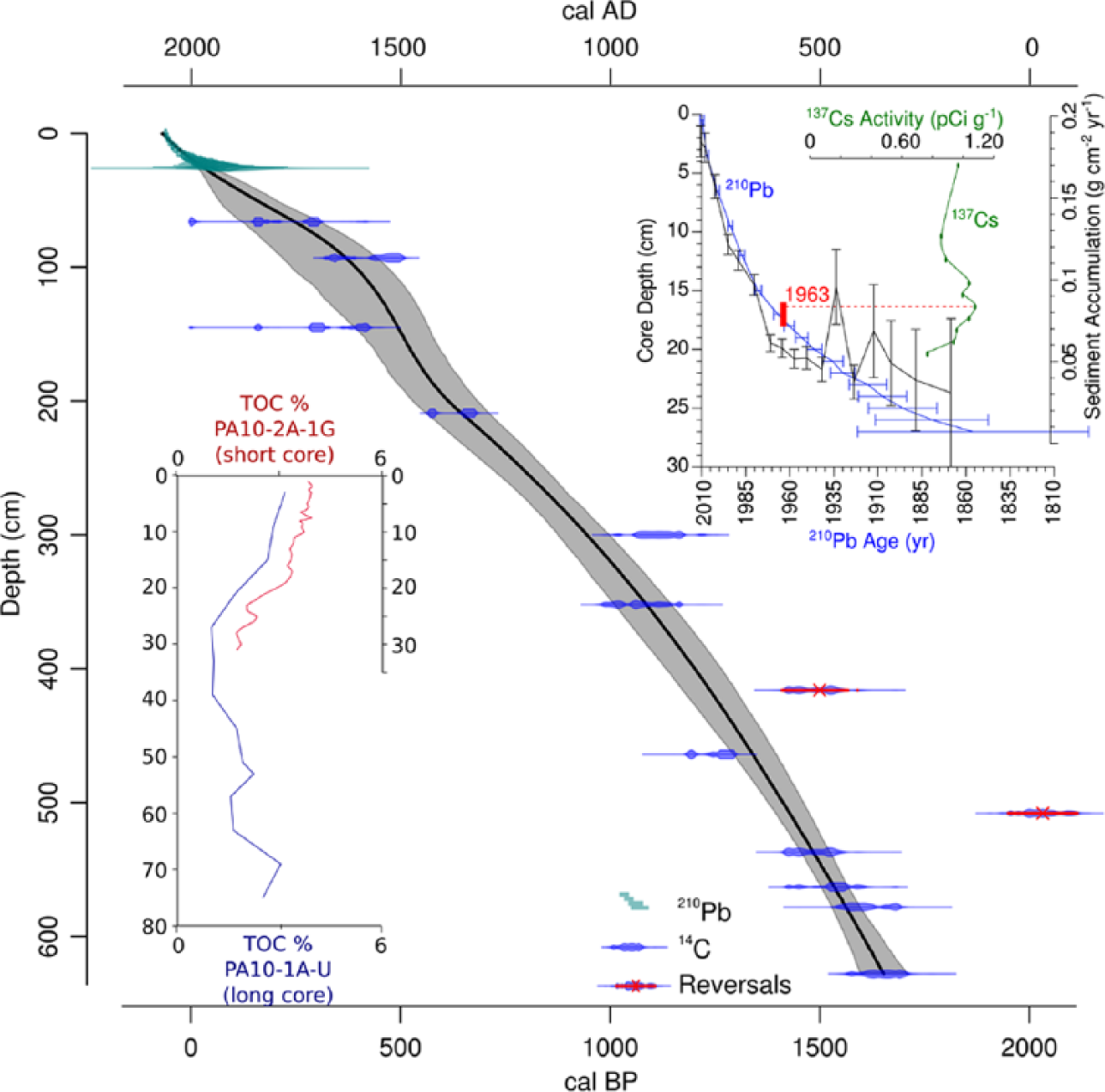
Chronological model of the studied sequence based on weighted spline regression (Blaauw, 2010) of 13 AMS 14C dates from the long core (blue lines) and 210Pb dates (green lines) from the short core. Two reversal dates are also represented (red crossed dates). The black continuous line represents the age–depth function framed by error lines (grey shaded area). At top-right is shown the agreement between 137Cs and 210Pb dating, and the sediment accumulation rate for the first 30 cm of the core. At bottom-left is represented the good correlation between the short core PA10-21-1G (red) and the main long core PA10-1A-U (blue) using TOC (%) values.
Results
Chronological model
La Parra sedimentary sequence described in this paper is based on 11 AMS 14C dates from wood samples (13 total, with two discarded reversals) (Table 1). The chronological model spans from the 3rd century
Sedimentary facies and units
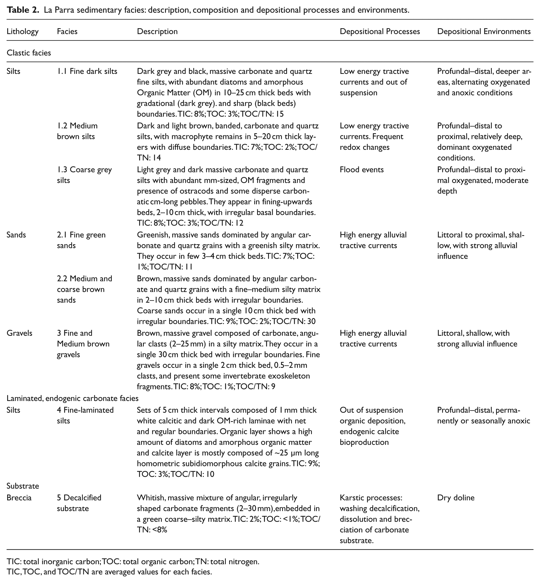
Sedimentological description of surface sediments obtained from 21 short cores allows three main lacustrine environments to be defined across the basin (Barreiro-Lostres, 2012): (1) an external–littoral platform up to 2 m water depth, with aquatic vegetation stabilizing the substrate, deposition of coarse sand and silt sediments (facies 2.2 and 1.3, respectively; see Table 2) and with the presence of active gravity processes as rock falls, where rocks are detached from the northern vertical margin of the doline; (2) an internal–littoral to profundal–distal zone with a steep and narrow talus (2–10 m depth) with brown and grey coarse to fine silts (facies 1.3 and 1.1); and (3) a profundal–distal zone (10–16 m depth, 80 m wide) with deposition of banded grey silts grading to black, more organic silts in the deeper central areas (facies 1.1, 16–17 m depth).
La Parra sedimentary facies: description, composition and depositional processes and environments.
TIC: total inorganic carbon; TOC: total organic carbon; TN: total nitrogen.
TIC, TOC, and TOC/TN are averaged values for each facies.
The La Parra long core (PA10-1A-U) reached the Cenomanian greenish marl substrate, and so the whole lacustrine sequence deposited in the doline was recovered (Figure 1). The marl substrate (facies 5, see Table 2) shows evidences of carbonate dissolution, brecciation and alteration and clay enrichment, common in carbonate substrate after a prolonged period of karstification (Gutiérrez et al., 2008). The La Parra sedimentary sequence is mostly composed of clastic carbonate facies ranging from gravels (see Table 2, facies 3); fine and medium-coarse sands (facies 2.1 and 2.3 respectively); fine, medium and coarse silts (facies 1.1, 1.2 and 1.3 respectively); to finely laminated silts (facies 4). They are organized in fining-upward sequences from 10 to 60 cm thick. This great facies variability is notorious for a relatively small karstic lake (Table 2). Clastic carbonates are common in Iberian karst lakes and they reflect deposition in littoral (coarse facies) to distal (fine facies) settings influenced by variable lacustrine reworking and alluvial processes (see review by Valero-Garcés et al., 2014). Deposition in La Parra Lake is controlled by the carbonate nature of the watershed (source area), the varied intensity of the sediment delivery processes (run-off and creek activity) and the changing limnological conditions (water depth, organic productivity, bottom redox conditions). Although lake level fluctuations are difficult to quantify from clastic facies sequences, grain size and texture provide some constraints for depositional depths. Therefore, the short-core survey shows that massive to banded silts are common lacustrine facies in sublittoral to more profundal settings. Finely laminated facies (facies 4) in these karst lakes only appear when anoxic environments dominate the lake bottom, often associated with higher lake levels and/or limnological conditions conducive to more frequent water stratification (Julià et al., 1998; López-Blanco et al., 2011; Romero-Viana et al., 2009a; Valero-Garcés et al., 2014). The occurrence of gravels (facies 3) and coarse sands (facies 2.3) in the central areas of La Parra Lake indicates periods of increased erosion and run-off during likely lower lake levels.
Carbonate minerals (dolomite and calcite) are the main sediment component, and rather constant along the sequence (80–90% mean). They are mostly of detrital origin, eroded from the Cretaceous carbonatic rocks in the watershed and transported by the small creek entering the lake at the SW margin. Endogenic minerals (calcite as main component and secondarily aragonite and high-magnesium calcite) appear in five discrete intervals, either in fine-laminated facies because of the in-lake calcite precipitation or in coarser sandy and gravel facies, likely because of reworking of older lacustrine sediments. Laminated facies (facies 4, see Table 2) contain both white laminae made up of 3–5 µm calcite crystals and dark laminae composed of amorphous organic matter and silicates, similar to those found in other karstic lakes of the Iberian Peninsula (La Cruz, Romero-Viana et al., 2008; Zoñar, Martín-Puertas et al., 2008; Montcortès, Corella et al., 2010; Arreo, Corella et al., 2011), and interpreted as seasonal deposition of calcite precipitated in the epilimnion in summer during the climax of algal development (white laminae) and clastic material deposited during autumn–winter (dark laminae). This lamination is associated with low energy sedimentation environments, favoured by water stratification during high lake levels and prone to anoxic redox conditions in the bottom (Brauer, 2004).
From the bottom to the top, seven sedimentological units (VII to I, Figure 3) have been characterized. The units are defined by the occurrence of distinctive facies and the boundaries are set at abrupt changes at the base of fining-upward sequences. The basal Unit VII (640–620 cm) is bounded by the Cretaceous basement at the bottom and the onset of banded grey silts at the top. It comprises a mixture of decalcified silty matrix (see Table 2, facies 5; >90% clay minerals and quartz) and large carbonate clasts (1–5 cm of diameter) with irregular and angular morphologies. Unit VI (620–570 cm) is composed of medium to coarse banded silts (see Table 2, facies 1.2 and 2.2) and finely laminated silts (facies 4) with presence of endogenic carbonates (calcite, and second, aragonite and high-magnesium calcite). This unit represents the onset of lacustrine sedimentation, and the upper boundary is set in the first occurrence of sandy facies. Unit V (570–400 cm) started with a 60 cm thick fining-upward sequence comprising fine and coarse (see Table 2, facies 2.1 and 2.2, respectively) and medium silt (facies 1.2), followed with deposition of five fining-upward sequences (darker coarse–medium silts, facies 1.2 and 1.3). Unit IV (400–250 cm) is separated from Unit V by the presence of a unique 20 cm thick coarse gravel layer at 400 cm (facies 3). Unit IV is composed of three fining-upward sequences of alternating medium to coarse silts (facies 1.2 and 1.3, respectively) in layers with irregular, erosive bases. The base of Unit III (250–95 cm) is set at a coarse sandy interval (facies 2.2); the occurrence of fine-laminated sediments with endogenic carbonates (calcite + aragonite + high-magnesium calcite; facies 4) singles out this unit. Internally, it is composed of seven fining-upward sequences including coarse silts (facies 1.3, 15 cm mean thick intervals) and fine-laminated silts (facies 4, in c. 5 cm thick sets), with punctual intercalation of coarse sands (facies 2.2, 5 cm thick). Unit II (95–40 cm) is composed of coarse banded silts (facies 1.3) with high TOC/TN values deposited after a thin coarse sandy interval (facies 2.2) at the base. Unit I (40–0 cm) is characterized by deposition of fine–medium dark grey silts (facies 1.1 to 1.2) topped by coarse dark silts (facies 1.3), with low TOC/TN values. Most units (V, IV, III and II) show a general fining-upward trend, and within each unit, sediments are also organized in fining-upward sub-sequences (sand–silt or coarse–fine silts). The only coarsening upwards sequence occurs in Unit VI.
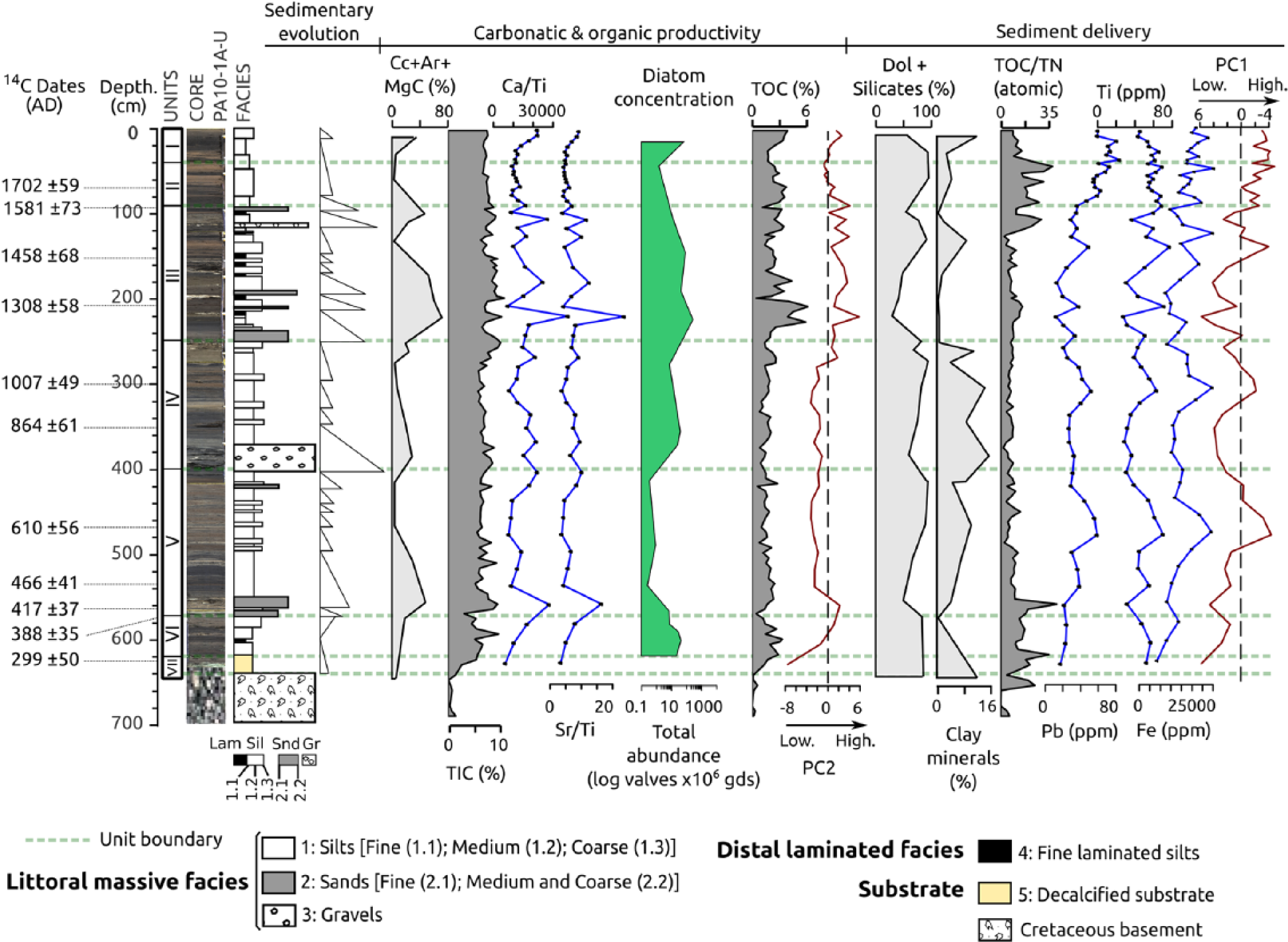
Sedimentary sequence of the PA10-1A-U core in depth (cm), with subdivision in units, core image, sediment stratigraphy and sedimentary evolution organized mostly in fining-upward sequences. Profiles for detrital (Do: Dolomite and Silicates), clays and endogenic (Cc: Calcite, Ar: Aragonite and MgC: Magnesian Calcite) minerals are expressed in percentages. Geochemical stratigraphy shows main quantitative ICP ratios (Ca/Ti, Sr/Ti) and Pb, Ti and Fe values (blue dotted lines), expressed in ppm. First (PC1) and second (PC2) principal components of the Principal Component Analysis (PCA) are plotted in red. Negative values of the first PCA eigenvector (PC1) represent increased detrital input, while positive values of the second eigenvector (PC2) are interpreted as higher biological productivity. TIC (%), TOC (%) and TOC/TN (atomic) values along the sequence are represented in dark grey. Dates are cal. yr
Geochemistry
TIC values along the sequence show a slight variability around mean values of 6%, with the lowest values at the base of the core and the highest values associated with fine-laminated facies (Figure 3). TOC content follows a similar trend to TIC (~3% mean), with the highest values in finely laminated facies (6–7%) and towards the top Unit I (4.5%). TOC/TN atomic ratios show large variability (3–40). The highest values (40) are located at the base of the sequence (Unit VII) and towards the top of Unit III and in Unit II. Geochemical composition is driven by the detrital nature of the sediments. Ca/Ti and Sr/Ti ratios present relatively low values along the Units VI and V, except at the bottom of Unit V (560 cm), and a slightly increasing trend in Unit IV. Ca/Ti and Sr/Ti ratios show peak values in Unit III during the deposition of finely laminated silts and in recent times (Unit I). Ti, Pb and Fe values follow a similar trend on the whole sequence, with distinctive peaks at 470 cm (Unit V), 310 cm (Unit IV) and an increasing trend from 250 cm (start of Unit III) towards the top of Unit I (Figure 3).
The principal component analysis (PCA, Figure 4) of the geochemical dataset including ICP and LECO results shows that the first two components explain 48% of the total variance of the dataset (26% the first eigenvector and 22% the second). The remaining PCA components explain variance percentages <12%, and they have not been taken into account. Negative values of the first principal component (PC1) are related to elements associated with clastic input (Fe, Ti, Pb, Si, Al) and with high TOC/TN values, suggesting that terrestrial organic matter (plant macrofossils and soil organic matter, see Meyers and Lallier-Vergés, 1999) enters the lake with the terrigenous material. PC1 and detrital mineral (dolomite + quartz + clay minerals) profiles show similar patterns. The second principal component (PC2) is related to chemical elements associated with in-lake biological and endogenic carbonate productivity, such as Ca, Sr, TOC and TIC (Figure 4). The plot of PC1 with respect to the sample core depth highlights three short intervals of higher clastic input (negative values) to the lake in Units V, IV and III (c.
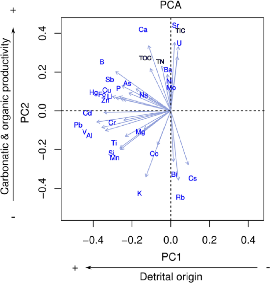
Principal Component Analysis (PCA) of the PA10-1A-1U core geochemical composition (TOC, TIC, TOC/TN – black, and major and trace elements from ICP – blue). Dataset contains 35 variables and 52 cases. The first eigenvector (PC1) highlights the detrital inputs, whereas the second eigenvector (PC2) has been interpreted as changes in carbonatic and organic productivity.
Diatoms
Diatom preservation is good along the record except for the samples from sandy intervals – for example, 440 cm (
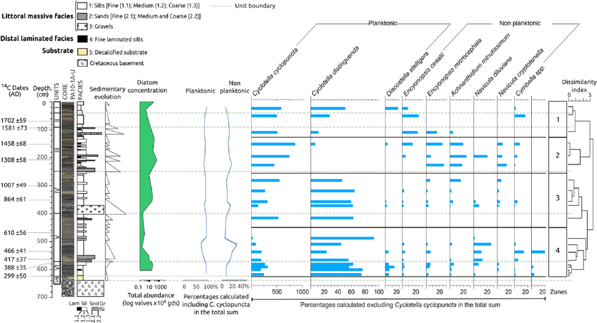
Main diatom species distribution in La Parra sequence. The most abundant species are planktonic Cyclotella cyclopuncta and Cyclotella distinguenda; non-planktonic group includes benthonic and tychoplanktonic species. Values are expressed in percentages, excluding Cyclotella. Diatom concentrations are expressed in valves per gram of sediment.
The bottom of diatom zone 4 (Unit VI) has relatively high diatom abundance with high proportions of Cyclotella distinguenda and the presence of Discostella stelligera. At the top of zone 4 (Unit V), diatom concentration and Cyclotella cyclopuncta abundance have their lowest values, while Cyclotella distinguenda and non-planktonic diatoms (Navicula diluviana) are the most abundant. In zone 3 (Unit IV), there is a recovery in diatom concentration, again dominated by Cyclotella cyclopuncta and Cyclotella distinguenda. The highest diatom concentration is in zone 2 (Unit III), which also shows maximum values of Cyclotella cyclopuncta, and minimum of Cyclotella distinguenda. This zone also has high abundance of non-planktonic taxa such as Achnanthidium minutissimum, Encyonopsis microcephala and Encyonopsis cesatii. In zone 1 (Units II and I), Cyclotella distinguenda increases in abundance again, with persistent high values of Cyclotella cyclopuncta; the most recent sample is characterized by an increase in Discostella stelligera and in total diatom abundance.
Discussion
Depositional evolution of La Parra
The decalcified sediments of the base of La Parra sequence (Unit VII, 640–620 cm) represent the top of the karstified Cretaceous substrate. Prior to
Lake La Parra sedimentary PA10-1A-U sequence in calibrated years
Deposition of brown fine silts with higher TOC, TIC and increasing Ca/Ti and Sr/Ti values (Unit VI, 620–570 cm,
The occurrence of coarse sands in the centre of the lake underlines the drastic limnological change at the onset of Unit V (570–400 cm,
Unit IV (400–250 cm,
Unit III (250–95 cm,
The absence of laminated facies and the return to deposition of alternating light and dark grey silts marks the onset of Unit II (95–40 cm,
The top Unit I (40–0 cm,
Cañada del Hoyo hydrological and environmental changes for the last 1600 years
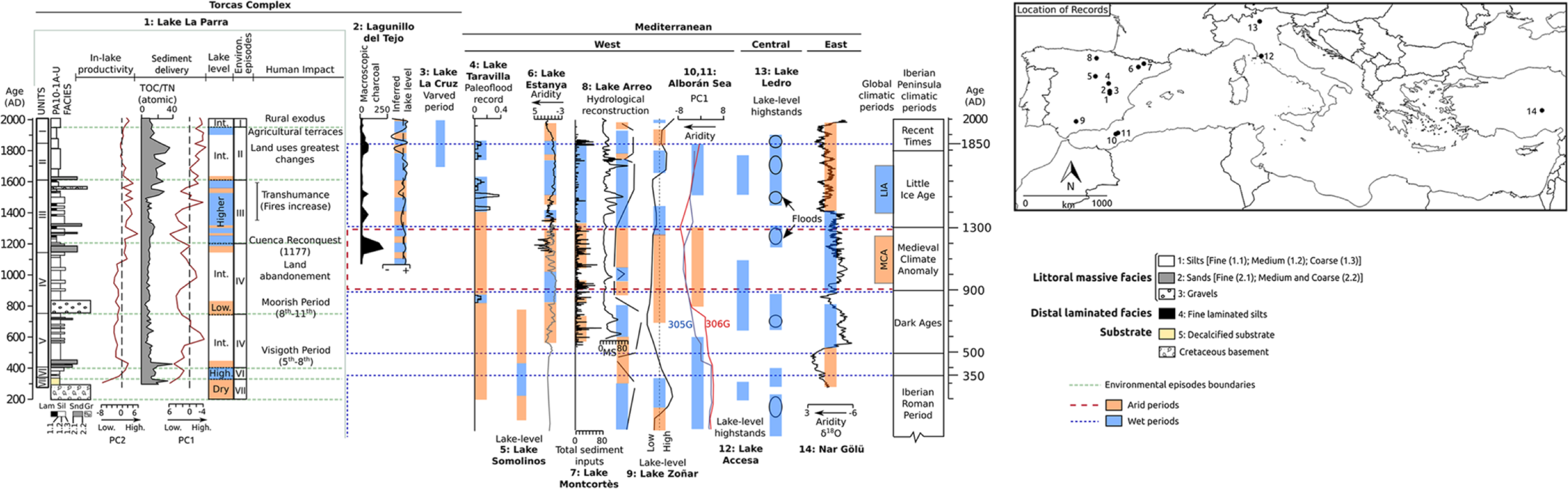
Lake records spanning the last millennium are available from three lakes of the Cañada del Hoyo karstic system (Figure 1): La Cruz (Burjachs, 1996; Julià et al., 1998; Rodrigo et al., 2001; Romero-Viana et al., 2008, 2009a, 2011), Lagunillo del Tejo (López-Blanco et al., 2011; Romero-Viana et al., 2009b) and La Parra (this study). Although chronological models do not have similar resolution (Figure 1), and the proxies used to reconstruct lake level and environmental changes differ from one another, the proximity of these lakes provide an opportunity to evaluate the regional significance of reconstructed hydrological/environmental changes in a context of similar climate forcing and human impact. Therefore, differences in climate forcing and human impact can be discounted in interpreting these environmental records. Furthermore, this study shows how some particular lake features may control the sensitivity of the system to record past changes. The 14C age model for Lake La Parra is the most robust of the three sites: 11 14C AMS dates versus 1 for Lake La Cruz and 5 for El Lagunillo.
Palaeohydrological changes
The main episodes of hydrological change during the c.
The rapid change in the hydrological behaviour of La Parra sinkhole at about
Sedimentological and geochemical indicators show a multi-decadal variability in lake level during
Human impact and lake dynamics
The main periods of human impact in La Parra watershed as indicated by PC1 values (Figure 3) occurred at the end of the Visigoth Period and the early Moorish Period (c.
The other two lake records from Las Torcas also show higher human activities in the watersheds during medieval times. Human impact in the watershed was mainly because of transhumance practices that peaked during the 15th–16th centuries (highest cattle heads around
The return to massive silt deposition with coarser silt intervals and the highest TOC/TN ratios of the sequence in La Parra point to intensified erosion in the lake’s basin, higher input of allochthonous sediments and terrestrial organic matter and relatively shallower water levels during the
Interestingly, each lake in the Cañada del Hoyo complex might record a different evolution during this period of the highest human pressure in the region. Some of the differences may be because of the age model uncertainties and the varied sensibility of the proxies used for each palaeoenvironmental reconstruction. However, watershed topography, bathymetry and land uses seem to play a definitive role in each lake basin. In Lagunillo del Tejo, lake levels dropped and erosion increased because of the construction of agricultural terraces within the lake basin (López-Blanco et al., 2011; Romero-Viana et al., 2009b). Lake La Cruz maintained a high water level with varves sedimentation until present day (Julià et al., 1998). In La Parra, sediment delivery (PC1) remained high and bioproductivity as indicated by PC2 and diatom abundance remained low. Human impact was larger in Lagunillo del Tejo than in La Cruz and La Parra because of the topographic configuration of the watershed (more available flat areas for farming) and its shallower nature (< 7 m compared with 17 in La Parra and 25 in La Cruz).
Timing of palaeohydrological changes in the Iberian Peninsula
The main palaeohydrological changes identified in Las Torcas sequences have been documented in most Iberian records, but the timing shows noticeable differences.
The pre-
Lower lake levels, evidences of increased aridity and a decrease of flood intensity and frequency have been documented all over the Iberian Peninsula somehow synchronous to the ‘MCA’, from
The first evidence for wetter conditions and higher lake levels after the ‘MCA’ occurred almost at same time (~
The change towards drier conditions in Lake La Parra at the end of the ‘LIA’ (about
Mediterranean variability
La Parra main hydrological climatic-related changes are in agreement with the main West (Ahmed et al., 2013; Lebreiro et al., 2006; Magny et al., 2013; Nieto-Moreno et al., 2011, 2013) and Central Mediterranean (Magny et al., 2013) climate reconstructions, although most available lacustrine records from these regions lack enough temporal resolution during the last 2000 years to establish reliable comparisons (Jones et al., 2009).
The wetter conditions in Lake La Parra at the end of the IRHP (
On the contrary, La Parra record shows an opposite hydrological pattern compared with East Mediterranean sites, as Nar Gölü (Jones et al., 2006) and the Dead Sea (Neumann et al., 2007), and supports the hypothesis (Roberts et al., 2012) of an East–West Mediterranean palaeohydrological see-saw during the last two millennia (Figure 6). This antiphase pattern between western and Eastern Mediterranean records has been explained by atmospheric teleconnections between the North Sea and the Caspian Sea (Jones et al., 2006) and demonstrates that the ‘LIA’/‘MCA’ hydroclimatic pattern in the Mediterranean was determined by a combination of different climate modes (including North Atlantic Oscillation (NAO) forcing) along with major physical geographical controls.
The main hydrological and climatic changes identified in lake La Parra coincide with two Holocene rapid climate changes (RCCs) described by Mayewski et al. (2004) during the last millennium (
Conclusion
The sedimentary record of Lake La Parra demonstrates high sensitivity to hydrological changes of small sinkholes and rapid response to human induced land use changes in the watershed. The main periods of human impact in the watershed occurred at the end of the Visigoth Period and the early Moorish Period (c.
The record provides a coherent palaeohydrological reconstruction for the past 1600 years showing an arid period prior to c.
Although similar palaeohydrological evolution occurred in most Iberian lacustrine records, La Parra supports latitudinal gradients within the Iberian Peninsula, with increased humidity during Iberian–Roman times restricted to southern Spain, and early onset of the ‘MCA’, and the humid phases of the ‘LIA’ starting and ending earlier in the central Iberian Range compared with the Pyrenean Domain and southern Spain. Lake La Parra record agrees with a complex pattern of wetter and drier intervals during the ‘LIA’. The La Parra record also supports the hypothesis of antiphasic behaviour between Western and Eastern Mediterranean, suggesting an active role for NAO dynamics over the past two millennia in the Western Mediterranean climate patterns. The documented heterogeneity through space and time of main global climatic phases stresses the need to integrate regional differences in global synthesis.
Footnotes
Acknowledgements
We thank Mark Abbott and the University of Pittsburgh lab staff for their help with the ICP analyses. We also thank Simón Guadalajara, the Regional Government (Junta de Comunidades de Castilla–La Mancha), and numerous colleagues involved in the field campaigns and the IPE-CSIC laboratory services. The authors also want to thank Dr Penélope González-Sampériz for the help with botanical matters. We also like to thank the two reviewers whose comments and criticisms have helped us to improve the manuscript.
Funding
This research has been supported by the GLOBALKARST (CGL2009-08415) and GRACCIE – Consolider CSD2007-00067 projects funded by the Spanish Ministry of Economy and Competitiveness and by the I-LINK programme (I-LINK0510) funded by the CSIC. F. Barreiro-Lostres acknowledges the funding from the CSIC ‘JAE-PreDoc’ programme.