
Abstract
The identification of wetter and drier phases from the last deglaciation to the Late Holocene has been a valuable outcome of palaeoenvironmental (chiefly palynological) studies of northeastern Australia conducted over the past 40 years. Few studies have, however, focussed on the identification of wetter and drier phases in the wet tropics, and none have set their focus on the last 4000 years, a period when northeastern Australia is generally accepted to have experienced increased El Niño/Southern Oscillation (ENSO) activity. The present study provides this palaeoclimatic information using the degree of peat humification as the main palaeoclimatic proxy. To identify regional climatic signals in the peat record and differentiate these from local signals induced by particular basin hydrology or ecology, sedimentary sequences from two geographically separated swamps on the Atherton Tableland in north Queensland are examined. Wet and dry shifts are detected in the humification records for Bromfield Swamp (core BSAT03) and Mount Quincan crater swamp (Q2). Seventeen wet shifts are detected in both records with 12 shifts showing good cross-correlation at the following dates (with 2σ range): 3990/3960 (4090–3850), 3480/3550 (3640–3420), 2950/2990 (3080–2790), 2860/2880 (2980–2700), 2560/2610 (2730–2450), 1880/1820 (2100–1740), 1430/1410 (1660–1320), 1170/1080 (1390–1020), 990/1010 (1100–790), 610/640 (710–490), 290/300 (330–180) and 120/150 (190–40) cal. yr BP. A particular dry phase, initiated by dry shifts at 4090 cal. yr BP (Bromfield Swamp) and 4330 cal. yr BP (Mount Quincan), reaches its greatest strength at 4050 cal. yr BP.
Keywords
Introduction
Identification of wetter and drier phases from the last deglaciation (or Termination 1) around 18,000–11,000 yr BP (Nash and Metcalfe, 2012) through to the Late Holocene (Walker et al., 2012) has been an important result of palaeoenvironmental studies in the wet tropics of northeastern Australia (Haberle, 2005; Hiscock and Kershaw, 1992; Kershaw, 1970, 1971, 1975, 1994; Kershaw et al., 2007; Kershaw and Nanson, 1993; Kershaw and Nix, 1988; McGlone et al., 1992; Moss and Kershaw, 2000; Tibby and Haberle, 2007; Turney et al., 2004; Walker, 2007). Of these studies, only the work of Turney et al. (2004) has focussed on the identification of wetter and drier phases in the wet tropics. Using selected palaeoclimate proxies including peat humification, Turney et al. (2004) recorded millennial-scale dry periods from the Late Pleistocene to the Middle Holocene (Walker et al., 2012).
The Late Holocene climate of northeastern Australia is of particular significance to climatologists and hydrologists for it records increased variability, specifically effective precipitation (Reeves et al., 2013). The region over this period is exposed to a strengthening of the El Niño/Southern Oscillation (ENSO) phenomenon and a weakening of the monsoon (Shulmeister and Lees, 1995). As a result, wet La Niña events of short duration are observed, alternating with protracted periods dominated by El Niño, long droughts and fire (Reeves et al., 2013).
Humification and its utility as a palaeohydrological proxy
The process of humification, whereby organic matter decays and is converted into humic and fulvic acids and humin, normally occurs under oxygenated conditions in peatlands and soils. In saturated peatlands, humification processes chiefly occur in the acrotelm or surface aerobic horizons (Ingram, 1978). Further anaerobic decay occurs at depth in the catotelm or saturated subsurface horizons, but at a much slower rate (Chambers et al., 2011). The rate of decay in each peat sequence is unique, subject to various factors including plant taxa composition, water content, available oxygen, temperature and microbial populations (Charman, 2002).
Humification has been used as a proxy for climate change for several decades. Specifically, it has been used as an indicator of past rainfall variability recorded in Late Pleistocene and Holocene peats. Most of the development and refinement of the technique has been performed on ombrotrophic peats from the boreal and temperate zones of northern Europe (Aaby, 1979; Borgmark, 2005), the United Kingdom (Blackford, 1993; Blackford and Chambers, 1991, 1993, 1995; Chambers et al., 1997; Mauquoy and Barber, 1999) and more recently North America (Booth and Jackson, 2003; Payne and Blackford, 2008). In the last decade, humification records have been produced for peats in east China (Ma et al., 2009), northeast China (Huang et al., 2013) and the Tibetan Plateau (Wang et al., 2010).
There has been limited use of peat humification analysis as a proxy for rainfall variability in the Southern Hemisphere, mostly in cool temperate environments. Multiproxy analysis of a peat sequence from a raised bog in the Valle de Andorra, Argentina, allowed researchers to construct a Middle–Late Holocene record of climate change: peat humification analysis defined an abrupt cooling event some 2800 years ago (Chambers et al., 2007), reinforcing the proposition of solar forcing of climate change in the Holocene (Renssen et al., 2006). A peat humification record, coupled with records of testate amoebae, pollen and macrofossils were used to reconstruct Holocene vegetation and climate change in the South Island of New Zealand (Wilmshurst et al., 2002) and to assist identification of changes in surface wetness for an ombrotrophic watershed blanket bog (Wilmshurst et al., 2003).
The first record of peat humification for northeastern Australia was obtained from Lynch’s Crater on the Atherton Tableland. Fine-resolution sampling of an 11-m sediment core, representing a near-continuous record of deposition over the past 45,000 years, identified periods of greater and lesser surface wetness through the peat profile (Turney et al., 2004). Greater surface wetness was interpreted as indicating a wetter climatic phase and lesser surface wetness indicating a drier climatic phase. Following spectral analysis of the humification data, a millennial-scale cycle of 1490 years and semi-processional cycle at 11,900 years were identified in the record. The shorter 1490-year phases were identified as dry periods of frequent El Niño events caused by disruption of the trade winds over the tropical Pacific Ocean. The longer 11,900-year phases were seen as a semi-precessional cycle of longer term drying linked to North Atlantic climate though atmospheric and oceanic teleconnections (Turney et al., 2004). One of the restrictions of the study was the absence of an intact Late Holocene peat sequence for humification analysis, successive European-adapted agricultural land practices having stripped and mixed sediments at the peat surface (Kershaw, 1976, 1983).
Burrows et al. (2014) tested the robustness of humification as a proxy for relative precipitation, attempting to complete the Middle–Late Holocene humification record for the Atherton Tableland. Corroboration of the record was achieved through comparison with other proxy records, specifically pollen and non-pollen palynomorphs, C:N ratios and δ13C and macrocharcoal analyses.
The present study aims to demonstrate the strength of humification as a proxy for relative precipitation in the humid tropics of northeastern Australia and to complete the Late Holocene humification record for the Atherton Tableland. Validation is achieved through cross-correlation of humification records from two spatially separated sites, Bromfield Swamp southwest of Malanda and Mount Quincan crater swamp (hereafter Mount Quincan) southwest of Yungaburra. Support for the humification records is proved by other proxy records, specifically macrocharcoal and pollen analyses. Anti-correlation of wet and dry events is achieved with ENSO records from the tropical eastern Pacific (Moy et al., 2002).
Field sites
Location and geology
Bromfield Swamp (17°22′44″S, 145°32′27″E) is located 6 km southwest of Malanda township on the Atherton Tableland in northeastern Queensland (Figure 1). The Swamp surface (1.0 × 0.8 km) occupies the base of a large explosion crater or maar (Best, 1960; Bultitude et al., 1999; De Keyser and Lucas, 1968). With crater walls 50 m high and a diameter of approximately 1.7 km, the crater appears as a bowl-shaped feature on an undulating plateau of Late Cainozoic volcanics of the Atherton Basalt Province (Bultitude et al., 1999; Whitehead et al., 2007). The vegetated swamp surface at 754 m asl is easily differentiated from the gently sloping inner walls of the crater, which today support a suite of exotic pasture grasses and minor weed species. Small stands of mature rainforest and regrowth line the southern boundary of the swamp, testament to the original Complex Mesophyll Vine Forest (Tracey, 1982) that clothed the crater slopes and was selectively logged and then cleared for agriculture in the first decade of the 20th century.
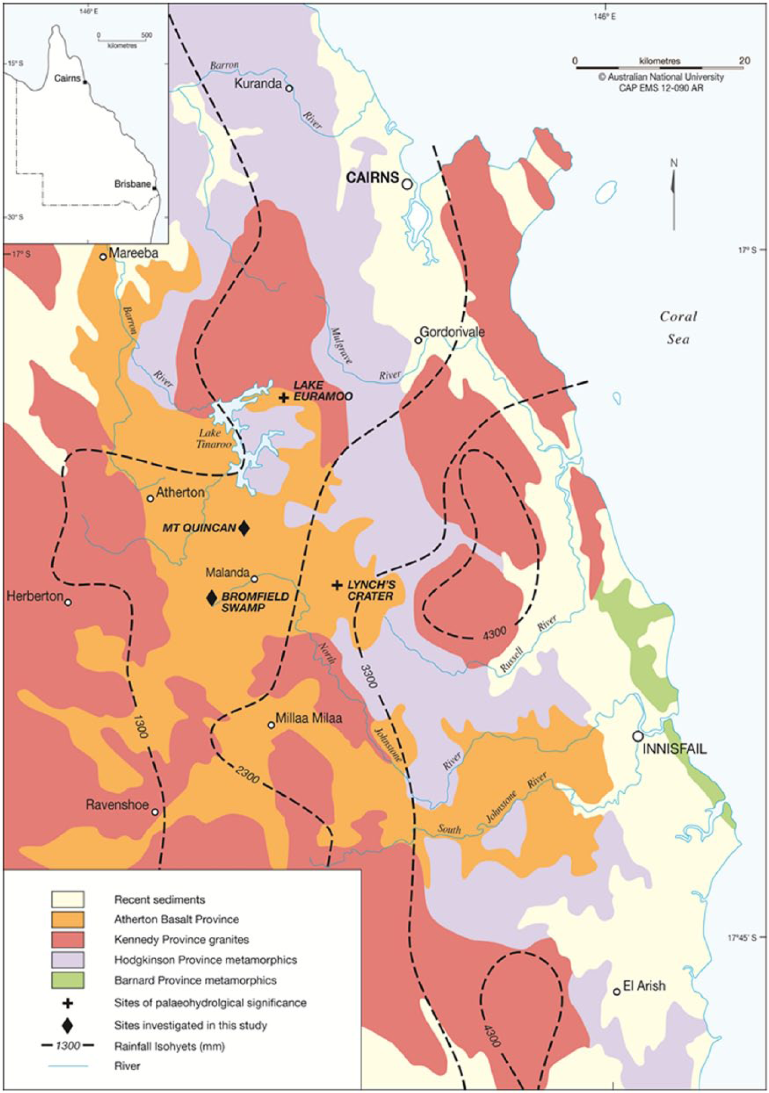
Location of Bromfield Swamp and Mount Quincan on the Atherton Tableland in the wet tropics of NE Queensland. Quaternary basalts cover a suite of igneous and metamorphic rocks of Palaeozoic age. Rainfall isohyets are shown (1300 mm in the west and 3300 mm to the east).
Mount Quincan (17°18′07″S, 145°34′53″E) is located 9 km north–northeast of Bromfield Swamp and 6 km north–northwest of Malanda. The swamp, considerably smaller than Bromfield, measures 0.3 km × 0.22 km and occupies the base of a scoria or cinder cone (Bultitude et al., 1999; Whitehead et al., 2007). Jardine (1925) provides an early description of Mount Quincan, less than 20 years after the subdivision of the rainforest-covered lands on the Atherton Tableland for agriculture: At a distance of rather less than two miles south of Yungaburra, at Chumbrumba, Mount Quincan rises to 2,930 feet (aneroid measurement). This hill is a fine crateriform cone whose summit is approximately 600 feet above the surrounding flats. The western walls of the crater are highest, being 200 feet above the general wall elevation. The crater is circular in outline and about 100 feet deep (300 feet below the hill summit). The inner slope of the crater is steep, the angle of slope being 45°, while the outer slope of the cone is about 30°. The floor of the crater is dry; water accumulates for a short time after a heavy downpour … The cone is dissected only to a minor degree and the crater is intact. The hill formerly was covered by a valuable red cedar forest. (p. 136)
Climate
The Atherton Tableland is situated in the wet tropics of northeastern Queensland, where precipitation is dependent on the austral summer monsoon system of the western Pacific Ocean (Muller et al., 2008), or Quasi-Monsoon (Gentilli, 1971; Kershaw and Van der Kaars, 2012), and the seasonal migration southward of the Intertropical Convergence Zone or ITCZ (Muller et al., 2008). Northward movement of the ITCZ and a northeast movement of the South Pacific Convergence Zone (SPCZ) signal the dominance of the ENSO phenomenon (Haberle et al., 2010). During these periods, December–February precipitation typically falls 150–300 mm below the seasonal average (Dai and Wigley, 2000).
Average annual precipitation is not uniform across the Atherton Tableland. The highest rainfall values are recorded on the eastern side of the Tableland adjacent to Mount Bartle Frere and the Bellenden Ker Range (which receive >4300 mm per annum, see Figure 1) and fall rapidly to the north and west across the Tableland. Bromfield Swamp receives approximately 1700 mm rainfall per annum (Kershaw, 1975); a more recent estimate is 1750–2000 mm per annum with most rain falling in the period December–April (Australian Wetlands Database, 2010). Mount Quincan, located northward of Bromfield Swamp, is estimated to receive 1400–1500 mm per annum (Kershaw, 1973).
Wetland eco-hydrology
Bromfield Swamp is identified as a lacustrine wetland (Australian Wetlands Database, 2010), with the water table positioned at the swamp surface for many months of the year. In contrast, Mount Quincan with a near complete cover of wetland plants including emergents, a relatively small surface area (<8 ha) and occupied by shallow, still waters (<2 m), is identified as a palustrine wetland (Aquatic Ecosystems Task Group, 2012). For the purposes of this study, both swamps are described as minerotrophic peatlands or fens, with water supplied by precipitation, and varying contributions of surface runoff and groundwater (Barber and Charman, 2005).
Bromfield Swamp is covered today by a mosaic of wetland plant communities and open water. Cyperus-dominated plant communities encircle the northern, eastern and western sectors of the Swamp, their boundaries shifting in response to the rising and falling of water levels over the wet and dry seasons (Kershaw, 1973, 1975). Rhynchospora corymbosa, a tall perennial to 2 m (Haslam, 2004), grows at the landward edge on peat with clay horizons, while further into the swamp occur dense stands of Cyperus lucidus, Cyperus sp., Typha domingensis and Juncus usitatus. Leersia hexandra, an aquatic or semi-aquatic perennial, forms thin floating mats over extensive areas of shallow water. On pools of open shallow water occur a range of aquatic and semi-aquatic herbs, including Nymphoides indica, Limnophila aromatica and Ludwigia peploides subsp. montevidensis. Exposed mud surfaces are colonised by the Pteridophyte Cyclosorus interruptus, a species with circum-Antarctic distribution (Parris, 2001).
Lakeward of the Cyperus-dominated communities of the Swamp boundary is found a species-rich plant community growing on a floating root mat more than 0.35 m thick (Kershaw, 1973, 1975). This community is dominated by Baumea rubiginosa and Cyclosorus interruptus. Conspicuous other taxa of the mat are sedges Rhynchospora brownii, Cyperus unioloides and Cyperus brevifolius; the grass Leersia hexandra; and herbs Persicaria strigosa, Philydrum lanuginosum and Oenanthe javanica. A separate community is recognised in the southern sector of the Swamp, dominated by Baumea rubiginosa and the Pteridophyte Blechnum indicum: also present here are Leersia hexandra, Oenanthe javanica and Persicaria strigosa. This community grows on a surface root mat overlying peat with clay horizons of varying thickness.
Areas of open water are present in the central parts of Bromfield Swamp (Kershaw, 1973, 1975). The water is of varying depth (commonly 1–2 m) and supports a range of floating leaf aquatic vegetation (Nymphoides indica, Brasenia peltata), emergents (Eleocharis dulcis, Eleocharis equisetina) and free-floating Azolla pinnata. In deeper or disturbed waters occurs the submerged aquatic Ceratophyllum demersum.
Mount Quincan is characterised by both the limited number of species present on the swamp and the concentric zonation of plant communities from the swamp edge to the centre (Kershaw, 1971, 1973). Around the landward edges of the swamp occurs a very narrow zone dominated by tussocks of Carex appressa; immediately adjacent in shallow water occur abundant Rhynchospora corymbosa, Cyperus lucidus and Cyperus sp. (Kershaw, 1971). In and around deeper pools of water at the boundary occur further Cyperaceae including Eleocharis equisetina and Baumea articulata, herbaceous shrubs and the Pteridophyte Cyclosorus indicum (Kershaw, 1973).
Moving towards the centre of the Mount Quincan swamp, the edge community is quickly replaced by a zone of variable width, dominated by abundant Lepironia articulata, the 2.5 m tall culms of the rush emerging from shallow water to 0.2 m (Kershaw, 1971, 1973). In the earliest description of plant communities on the present-day swamp surface, Kershaw (1971) described a further five zones: a narrow transition zone with Lepironia articulata and Blechnum indicum; a zone dominated by Blechnum indicum with some Poaceae and Lepironia articulata; a zone dominated by Poaceae with occasional Blechnum indicum; a zone on a floating root mat over water 1–2 m deep with abundant Poaceae and Blechnum indicum; and finally, a zone occupying much of the central swamp with abundant Cyclosorus indicum, Blechnum indicum and Poaceae. In subsequent descriptions of the plant communities of Mount Quincan, the six communities growing within the waters of the crater were incorporated into a single community (Kershaw, 1973, 1978, 1979).
Stratigraphy
The peats of Bromfield Swamp are covered by a root mat and approximately 1 m of freshwater (Kershaw, 1973, 1975). The peats vary in thickness, being 2–3 m thick towards the central swamp while thinning substantially landwards. Beneath the peats are 4 m of Early–Middle Holocene organic lake muds that accumulated in appreciably deeper water conditions than those of the peats. At the base of the sequence are clays, attributed to the Late Pleistocene to Early Holocene (Kershaw, 1973, 1975). Dating of selected sediment horizons within the sequence led Kershaw (1975) to suggest that accumulation rates were slowest in the basal clays, higher in the organic lake muds and most rapid in the peats.
Mount Quincan is covered by a root mat of living and decomposing vegetable matter. Of variable thickness (0.4–1 m), this mat is attached to the underlying peats around the perimeter of the swamp, but floats on a column of water of variable depth towards the centre of the swamp (Kershaw, 1971). The peats below the root mat and water column vary considerably in thickness, being more than 7 m thick over the central part of the swamp while thinning towards the edges of the swamp. Through the lowest 1 m of peat, the composition alters, with an increasing fraction of organic lake mud towards the base. A 30 cm thick layer of organic lake mud with an increasing clay fraction lies beneath the peats, while clays form the base of the sedimentary sequence (Kershaw, 1971, 1973). Radiocarbon dating of selected horizons within the sequence indicated a date of 5500 BP for the base of the peats and 7200 BP for the base of the sequence (Kershaw, 1973).
Methods
A continuous core of sediment, BSAT03 (9.53 m), was extracted from Bromfield Swamp (June 2009) using a rod-in-rod piston corer mounted on a floating platform. The core was taken from open water (1.1 m deep) adjacent to the floating vegetation mat, 270 m due west of the outlet into the North Johnstone River tributary. Core litho-stratigraphy and magnetic susceptibility measurements were determined in the laboratory, followed by subsampling at 1-cm intervals for macrocharcoal. A total of 122 samples through the peat profile were tested for degree of humification; 230 samples were also taken from the underlying organic lake mud.
Core Q2 (11.5 m) was extracted from Mount Quincan (dry season, October 2006) using a similar coring apparatus to that employed on Bromfield Swamp. The core was taken in 0.35 m of water from a site at the centre of the swamp, approximately 140 m due north of the southern swamp boundary. Core litho-stratigraphy and magnetic susceptibility measurements were determined in the laboratory, followed by subsampling at 1-cm intervals for macrocharcoal. In 2012, 273 sediment slices throughout the sediment sequence were tested for the degree of humification.
Geochronology
Radiocarbon dating was used to provide accurate chronologies for the sedimentary sequences from Bromfield Swamp and Mount Quincan. A total of 10 bulk organic samples from core BSAT03 and 16 organic samples (sedge seeds, fern fragments) from core Q2 were selected for dating. Ages were obtained by accelerated mass spectrometry (AMS) at the University of Waikato Radiocarbon Dating Laboratory in New Zealand; NOSAMS Woods Hole Oceanographic Institution; and the Radiocarbon Laboratory, Research School of Earth Sciences at the Australian National University. The dried, crushed samples were pre-treated with HCl–NaOH–HCl and washed with milli-Q and the insoluble residue freeze-dried for AMS analysis. Radiocarbon ages were calibrated using OxCal v4.2.2 (Bronk Ramsey, 2013) with the SHCal04 calibration curve (McCormac et al., 2004). Calibrated ages are displayed in cal. yr BP.
Humification
Measurement of peat humification in the two cores (BSAT03 and Q2) followed the laboratory protocol developed for the European ACCROTELM palaeoclimate project (Chambers, 2006; Chambers et al., 2011). Peat humification was measured on samples at either 1 or 2 cm contiguous intervals using a filtered (Whatman No 1 filters) NaOH (8%) extract from 0.2 g of dried peat, with percentage light transmission (3 repeats) at 540 nm measured on a double-beam Shimadzu UV-1800 spectrophotometer using distilled water as zero standard. Percentage light transmission values were plotted against depth (i.e. high percentage values representing little humification of peats and low percentage values representing increased levels of humification). The humification data were initially smoothed, using a 3-point moving average to remove anomalous values and then detrended by applying a fourth order polynomial. The residual values were then plotted against calibrated age: this technique reduced the impact of slow and ongoing catotemic decay and highlighted high frequency shifts in humic acid (Figures 4 and 5).
Macrocharcoal analysis
Preparation of samples for macrocharcoal analysis followed Stevenson and Haberle (2005), a modification of the laboratory procedure described by Rhodes (1998). Sediment samples at contiguous 1-cm intervals were processed from core BSAT03 and Q2, and macrocharcoal particles of two size fractions (125–250 micron, >250 micron) were counted under a stereomicroscope at 10× magnification and concentrations for each size fraction calculated (particles cm3). The two size fractions of macrocharcoal from each core were then used as an indicator of the proximity of fire to the swamp surface: particles > 250 microns are thought to be derived from local fires while particles 125–250 microns in size are conjectured to have travelled a far greater distance (Haberle, 2005).
Results
Age–depth models
A total of 26 samples contained sufficient carbon for AMS radiocarbon dating, and the results are shown in Table 1.
Accelerator mass spectrometry or AMS radiocarbon ages (14C yr BP) and calibrated ages (cal. yr BP) for Bromfield Swamp BSAT03 and Mount Quincan Q2 subsamples.
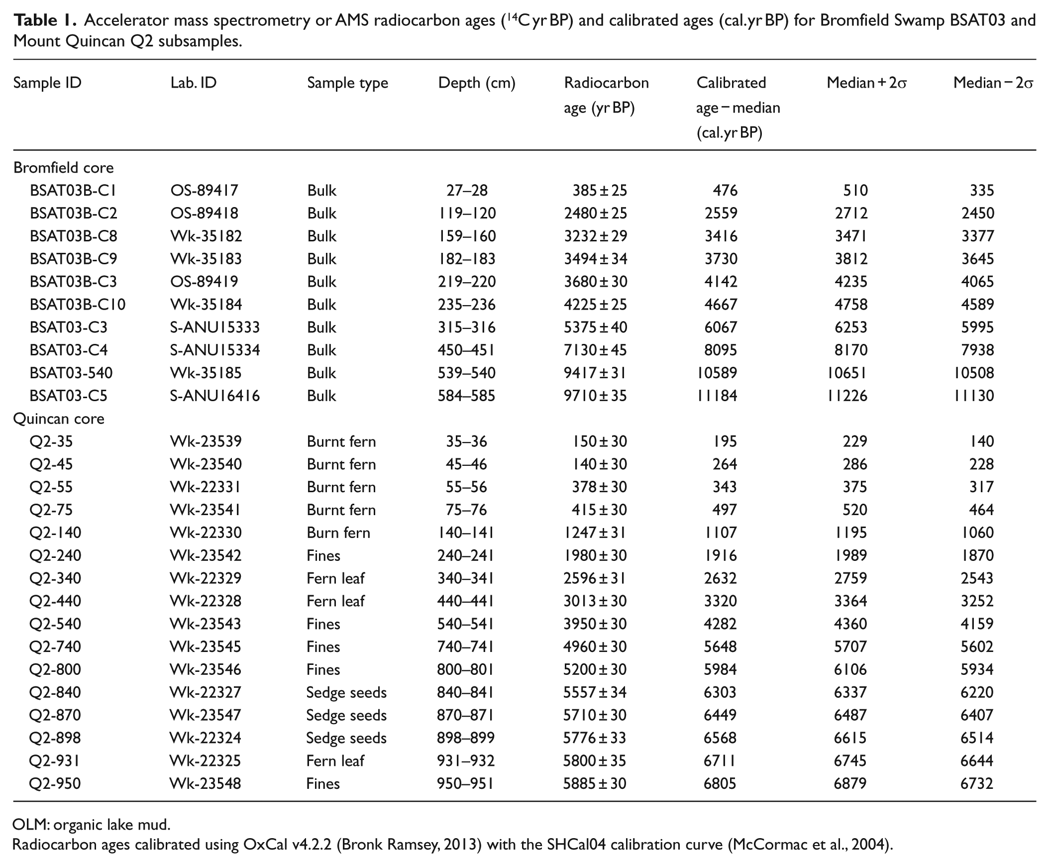
OLM: organic lake mud.
Radiocarbon ages calibrated using OxCal v4.2.2 (Bronk Ramsey, 2013) with the SHCal04 calibration curve (McCormac et al., 2004).
Changes in the rate of sediment accumulation in Bromfield Swamp and Mount Quincan are indicated on Figures 2 and 3, with age–depth models tested using OxCal v4.2.2 and the SHCal04 calibration curve. The P-sequence (1, 1) age–depth model applies Bayesian modelling (Bronk Ramsey, 2008) to interpolate between the horizons that are radiocarbon-dated, generating an age probability function for each depth. The model for Bromfield (Figure 2) shows that while peats have accumulated for little more than 4000 years, the longer Holocene history shows a slowing of accumulation during the final phase of organic lake mud deposition, swifter accumulation with peat initiation and a slight slowing of the rate from 3440 cal. yr BP (with a 2σ range of 3510–3390 cal. yr BP) through to the period of selective logging of rainforest tree species (principally Toona australis) in the period 1880–1900 (Birtles, 1982) and subsequent clearing of crater slopes in the first decade of the 20th century.
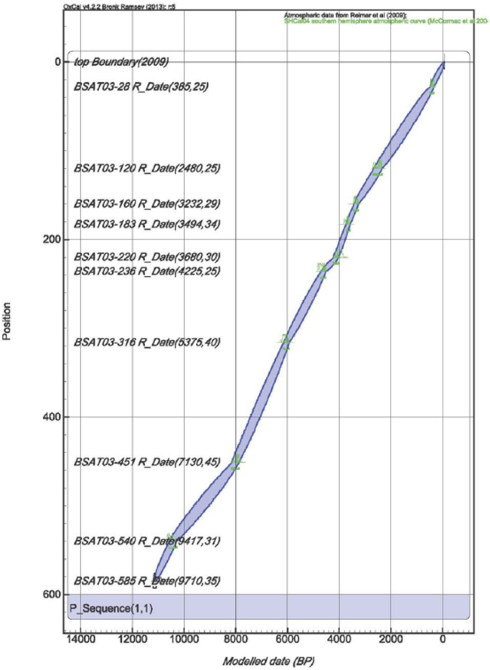
Age–depth plot for Bromfield Swamp. Constructed using 10 radiocarbon dates calibrated using OxCal v4.2.2 the P_Sequence command with the SHCal04 calibration data set.

Age–depth plot for Mount Quincan. Constructed using 16 radiocarbon dates calibrated using OxCal v4.2.2 the P_Sequence command with the SHCal04 calibration data set.
The model for Mount Quincan (Figure 3) shows rates of sediment accumulation within the crater have remained comparatively swift over the entire period of peat development when compared with those established for Bromfield Swamp. Following initiation of the peats in Mount Quincan crater approximately 6900 years ago, sediment accumulation rates were rapid for approximately 500 years, before falling slightly to the Middle Holocene. Accumulation rates then decreased further over the period 4280–3320 cal. yr BP. Subsequently, accumulation rates increased and remained constant, before finally rising again over the last 400-year interval.
The Bayesian models developed for Bromfield Swamp and Mount Quincan cores return an age probability distribution for contiguous 1-cm slices in the two stratigraphic records. Throughout the results and discussion sections, we use the median modelled age when identifying climatic events and macrocharcoal peaks, while acknowledging that there is a 2σ uncertainty (in the range of 150–400 years) associated with that central age. The modelled median and 2σ error ranges for identified wet and dry events are shown (see Tables 2 and 3) and featured in the two age–depth models (Figures 4 and 5).
Bromfield Swamp and Mount Quincan wet shifts (in cal. yr BP) and duration of wetter phases in years (estimated period of above-average precipitation).

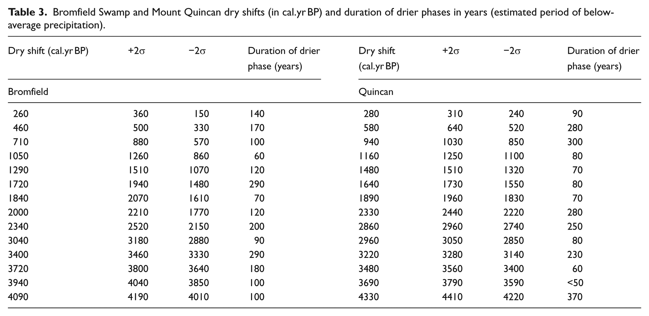
Bromfield Swamp and Mount Quincan dry shifts (in cal. yr BP) and duration of drier phases in years (estimated period of below-average precipitation).
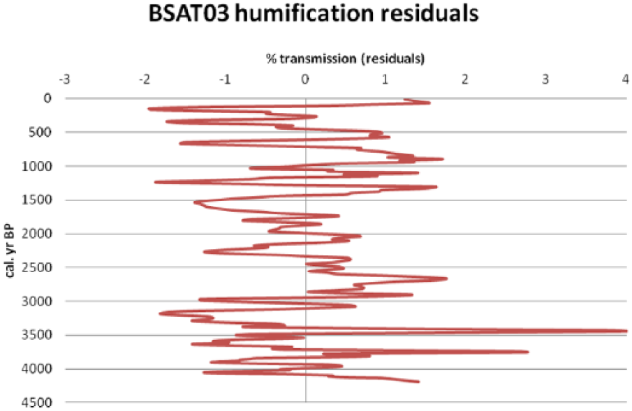
Peat humification record Bromfield Swamp. Data smoothed using a 3-point moving average, detrended by applying a fourth order polynomial, and the residuals plotted.
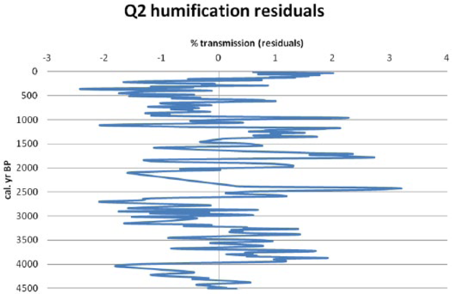
Peat humification record Mount Quincan. Data smoothed using a 3-point moving average, detrended by applying a fourth order polynomial, and the residuals plotted.
Stratigraphy
Bromfield Swamp and Mount Quincan share similar sedimentary profiles. The basal 3.5 m of Bromfield Swamp core (BSAT03) are a mix of fine silts and clays, with a small organic component. Overlying the fine clastic sediments are 4.0 m of organic lake muds containing abundant algal remains (including Botryococcus) and thought to have accumulated in lacustrine waters 4.5–30 m deep in the Early to Mid-Holocene (Kershaw, 1975). The upper boundary of the mud facies presents as a mix of organic lake muds and peat some 0.06 m thick. Carbon age–depth modelling (see Figure 3) indicates organic lake mud deposition ceased at 4120 cal. yr BP (2σ range of 4210–4040 cal. yr BP). The sequence is capped by 2.16 m of organic humified peat, deposited in little more than 4000 years. Dark brown to black in colour (Munsell 10YR 2/2–5YR 2.5/1), eight indistinct layers are identified (see Burrows et al., 2014). A mud–water interface core (BSAT-MW) from a site 30 m NE of BSAT03 records deposition of organic lake muds above the peat sequence. These sediments accumulated rapidly: a CIC Model of 210Pb dating indicating a mass accumulation rate of 0.148 ± 0.01 g/cm2/yr (see Burrows et al., 2014).
The basal 1.37 m of Mount Quincan core (Q2) are silts and clays, thought to have accumulated under lacustrine conditions in the period from 16,000 years ago to the early Holocene. Overlying the inorganic fine clastic sequence are 9.78 m of peat, deposited in approximately 6900 years: radiocarbon dating of organics in a sediment sample from 9.50 m returning a mean age of 6800 cal. yr BP (2σ range of 6880–6730 cal. yr BP).
The colour and components of the peats in Q2 change with decreasing depth through the profile. The physical features of the peats and the precise number of units is difficult to determine as the profile is incomplete (insufficient sample at individual spot depths, no samples for the interval 3.40–2.63 m) and some core sections have dried in storage. The peat from 5.26 to 1.66 m is mainly dark brown to black in colour and composed of fine detritus; exceptions being very dark brown (7.5YR 2.5/3) units between 3.90–3.86 m, 4.65–4.38 m and 5.08–5.06 m, which comprise coarse detritus. The unit above (1.65–0.86 m) is a very dark brown to black peat (10YR 2/2–10YR 2/1) comprising frequent fine detritus. The succeeding unit (0.86–0.80 m) is a very dark brown (10YR 2/2) peat comprising frequent fine detritus with some woody detritus to 5 cm in length. The peat from 0.80 to 0.11 m is a very dark brown to black (10YR 2/2–10YR 2/1) comprising frequent fine detritus. The topmost unit (0.10–0.01 m) is a dark brown to very dark brown (7.5YR 3/4–7.5YR 2.5/2) saturated fibrous peat with abundant sedge roots.
Humification records
The humification records for Bromfield Swamp (Figure 4) and Mount Quincan (Figure 5) show a high degree of variability through the Late Holocene with higher light transmission interpreted as indicating wetter periods and lower light transmission signifying drier intervals (Burrows et al., 2014; Sillasoo et al., 2007). The smoothed humification records for both sites show a major shift, which must be recognised prior to interpretation of the data: for Bromfield Swamp, a dramatic fall 4200–4050 cal. yr BP reflecting both a swift change in lithology from an organic lake mud to a peat (the product of terrestrialisation) and an intense dry phase (this dry event is similarly recorded at Mount Quincan between 4330 and 4050 cal. yr BP).
Bromfield Swamp
The smoothed and detrended data (Figure 4) emphasise the higher frequency oscillation in peat humification possibly linked to surface wetness of the swamp. Seventeen shifts to wetter conditions are recognised with Table 2 showing the modelled age with a 2σ range in cal. yr BP of each wet shift and duration of the wetter phase (in years). Additionally, 14 dry shifts are tentatively recognised in the peat humification record (Table 3). The age–depth model indicates that 0.01 m of peat accumulates every 18 years, so the humification record is not of sufficiently fine resolution to allow detection of decadal or sub-decadal hydrological change. Chronological precision is further lost as the graphed raw data are smoothed by using a 3-point moving average (Blackford and Chambers, 1995).
Mount Quincan
Seventeen shifts to wetter conditions are recognised with Table 2 showing the modelled age with a 2σ range in cal. yr BP of each wet shift and duration of the wetter phase (in years). Fourteen dry shifts are recognised in the peat humification record (Table 3). The age–depth model indicates that 0.01 m of peat accumulates every 8 years, so the raw humification record may allow detection of decadal-scale (but not sub-decadal) hydrological change. Smoothing of the raw data using a 3-point moving average does reduce the ability to detect decadal-scale hydrological change.
Macrocharcoal
Bromfield Swamp
Large macrocharcoal peaks are recorded during the initiation phase of the peat sequence at 4090 cal. yr BP, and between 3700 and 3620 cal. yr BP: both time periods coincident with dry shifts and ensuing dry phases. Isolated smaller peaks in the past 2900 years, notably those at 2860, 2820, 2620, 2560, 2130 and 1740 cal. yr BP coincide with wet phases. Following initiation of the last dry shift at 260 cal. yr BP, macrocharcoal values rise to 67 pieces per cc. of sediment at 200 cal. yr BP.
Mount Quincan
A near-continuous record of macrocharcoal exists throughout the peat profile to a depth of 5.32 m (or 4200 cal. yr BP), with 16.7% of subsamples recording ≥100 pieces macrocharcoal per cc. of sediment. When presented in graphical form, 34 individual peaks with maximum values above 100 pieces per cc. are seen. Immediately evident are peaks of charcoal at 4060, 3450, 3150, 2860, 2680, 1440, 1140, 1020, 900, 840, 770, 510, 390 and 330 cal. yr BP., coincident with 9 of the 13 drier phases. Seventeen peaks occur within identified wetter phases at 3410, 2610, 2550, 2420, 2350, 1950, 1910, 1740, 1530, 1380, 1300, 1230, 1070, 290, 120, 90 and 20 cal. yr BP. Macrocharcoal peaks at c. 3410, 2610, 1070 and 290 cal. yr BP occur at the identified commencement of wet shifts. A further three charcoal peaks cannot be identified with wetter or drier phases: peaks at 2320 and 2250 cal. yr BP correspond with a period for which there is no available humification data (insufficient peat samples for testing), while a large peak at 3560 cal. yr BP may correspond with a brief dry phase.
Discussion
The high-resolution humification records for Bromfield Swamp and Mount Quincan provide evidence of possible centennial- and millennial-scale climate change in the Late Holocene. To evaluate the strength and validity of the humification proxy, the data from the two sites is examined alongside high-resolution macrocharcoal data (Figure 6). The results show that the peat humification records identify climate variability through the Late Holocene and do not merely reflect changes in individual wetland plant taxa over time or local effects induced by fire in the immediate watershed or alterations in basin hydrology.
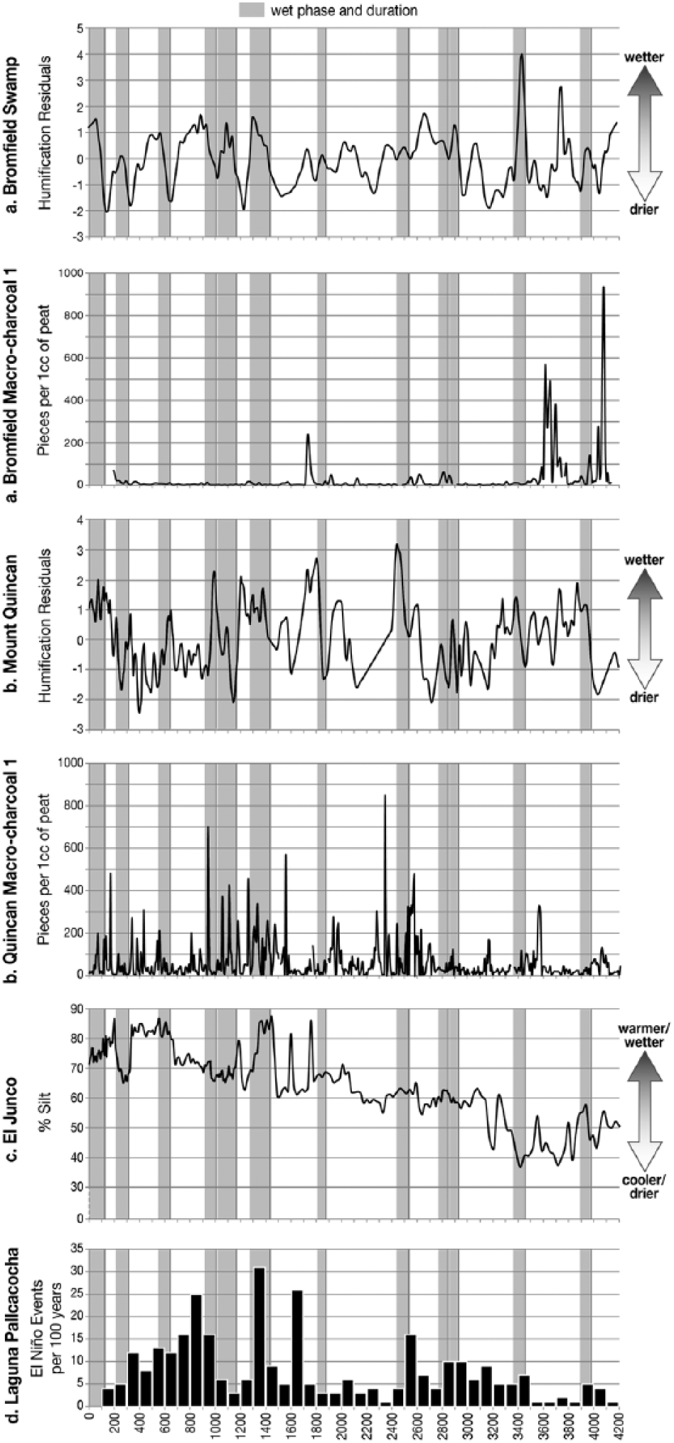
Proxy records of wet phases (Bromfield Swamp and Mount Quincan humification; El Junco grain-size distribution) and El Niño events per 100 years (Laguna Pallcacocha). Approximate commencement date of each correlated wet shift shown as solid black line; possible duration of each wet phase indicated by grey band. Details of the El Junco record can be found in Conroy et al. (2008), while details of the Laguna Pallcacocha record can be found in Moy et al. (2002).
Correlating and validating wet and dry shifts
Manipulation of the raw humification data by assigning a moving average and a detrending mechanism allows identification of wet shifts in the peat profiles of Bromfield Swamp and Mount Quincan for the past 4000 years. Seventeen wet shifts are detected for both Bromfield Swamp and Mount Quincan, with 12 of the calibrated dates for both sites showing a high degree of correlation. Specifically, agreement between dates is found at approximately 3990/3960, 3480/3550, 2950/2990, 2860/2880, 2560/2610, 1880/1820, 1430/1410, 1170/1080, 990/1010, 610/640, 290/300 and 120/150 cal. yr BP.
The best correlation between dated wet shifts for Bromfield Swamp and Mount Quincan is achieved for the period 1400–0 cal. yr BP. This correlation may be largely because of the accuracy of the age–depth models for Mount Quincan and Bromfield Swamp over the specified time interval. The Q2 age–depth model, well constrained over the time interval (constructed on five radiocarbon dates), shows a steady rate of peat accumulation. The age–depth model for BSAT03, while constructed on only one radiocarbon date within the specified time interval (480 cal. yr BP), does appear to support the contention that the rate of peat accumulation remained steady over a period of >2500 years (excluding a rapid increase in historic times).
Five of seven wet shifts recorded in BSAT03 and Q2 for the period 4000–2500 cal. yr BP show good correlation. A lack of correlation of wet events throughout the entire time interval may be because of inaccuracies in the two age–depth models, the age–depth model for BSAT03 constructed on three radiocarbon dates within the specified time interval and the model for Q2 constructed on two dates (3320 and 2630 cal. yr BP). What are apparent from both models are changes in the rate of sediment accumulation over the time interval: more radiocarbon dates would allow for more robust age–depth models with better interpolation to be constructed.
The period 2500–1400 cal. yr BP is notable for the lack of correlation between the two wet shift series (excepting possible correlation at 1880/1820 cal. yr BP). This is a time interval for which there are no radiocarbon dates for BSAT03 (Figure 2); as a consequence, possible variations in accumulation rates are not illustrated on the age–depth model. The age–depth model for Q2 (Figure 3), while achieving slightly greater resolution through this period with radiocarbon date at 1916 cal. yr BP, is also unable to display possible changes in rates of peat accumulation. The interpolated dates for individual sedimentary units in both peat profiles are consequently less accurate than for the period 4000–2500 cal. yr BP.
A wet shift recorded in the Mount Quincan sequence at 190 cal. yr BP has no analogue in the Bromfield Swamp sequence. The apparent absence of this wet shift in the Bromfield record may reflect the much lower average sediment accumulation rate of BSAT03 (average 51.5 cm/1 kyr) than Q2 (average 128 cm/1 kyr). Substantial changes in humification of short duration, the result of short-term variation in the climatic signal, will possibly be recorded in Q2 sediments. Such swift changes in humification may go undetected in an examination of BSAT03 core sediments, even though the sediment sampling resolution is fine (1–2 cm intervals).
To identify dry shifts in the peat profiles of Bromfield Swamp and Mount Quincan, the raw humification data for both sites were manipulated using the same methodology as that used to identify wet shifts. While 14 dry shifts were identified in the records of residuals for both cores, little correlation could be established between the two sets of calculated dates. A correlation was found, however, between individual dry shifts on the two swamps and fire in the landscape (evidenced by peaks of macrocharcoal) for the period 4200–2900 cal. yr BP. This suggests that dry shifts are a record of localised drier hydrological conditions affecting individual swamp surfaces and may not necessarily represent regional signals of prevailing drier conditions (Turney et al., 2004). In discussing the lack of correlation seen in the humification records for five sites in Alaska, Payne and Blackford (2008) concluded that fire and local hydrological changes (together with a plant species signal) may mask the climatic signal except during periods of substantial climate change. Additional fine-resolution humification and macrocharcoal records may consequently be required from several more peatland sites on the Atherton Tableland to validate this hypothesis.
The two charts of humification do show one period of cross-correlation that possibly indicates a time of substantial climate change (a dry phase) in the Middle–Late Holocene. At 4060 cal. yr BP, the lowest humification values are recorded for both Bromfield Swamp and Mount Quincan. Peaks of macrocharcoal (the largest in the Bromfield Swamp record) indicate fires burning in and around the craters of the two volcanic cones. Leading into this period of inferred intense dryness, the organic lake muds at Bromfield are replaced by peats: pollen analysis shows the muds to contain Botryococcus, Blechnum sp. and Ceratophyllum demersum indicating lake conditions; Cyclosorus sp. dominates the peats, possibly indicating the growth of the floating vegetation mat over shallow water.
Comparison with analogous regional studies
The timing of wet and dry shifts identified in this study accords well with other regional studies indicating increased climatic variability in northern Australia in the Late Holocene. Re-examination of a pollen record for Groote Eylandt in the Gulf of Carpentaria by Shulmeister and Lees (1995) identified an effective precipitation maximum in the Middle Holocene, a sudden fall in effective precipitation between 4000 and 3500 cal. yr BP and a return to higher effective precipitation in the last 2000 years. Lees (1992) identified phases of increased rainfall between 3500 and 2800, 2100 and 1600 cal. yr BP and at least a further two in the last 1000 years, during a period of increased aridity in northern Australia. A wetter phase c. 2600 cal. yr BP, recognised by Rowe (2007) in a study of freshwater swamp sediments from Mua and Badu Islands in the Torres Strait, accords particularly well with a wet phase of long duration recorded for both Bromfield Swamp and Mount Quincan.
An archive of tropical cyclone activity, obtained through δ18O analysis of a speleothem from the Chillagoe karst, 115 km WNW of Malanda, supports the two youngest wet shifts identified in the Bromfield Swamp humification record. A plot of δ18O values for a period of nearly 800 years has identified two clusters of higher intensity cyclonic events over an 800-year period, the first recorded for the period 550–450 cal. yr BP and the second recorded for the period 350–150 cal. yr BP (Nott et al., 2007). These clusters demonstrate a centennial-scale frequency to severe cyclones making landfall, or more specifically, a high magnitude cyclonic event every 200–300 years (Nott et al., 2007). Support for the Mount Quincan humification record is not as strong: while the cluster of higher cyclonic activity between 350 and 150 cal. yr BP corresponds with the youngest identified wet shifts, there is no evidence of a wet shift or proceeding wet phase between 550 and 450 cal. yr BP.
In testing the hypothesis of Holocene climate change in New Zealand, Wilmshurst et al. (2002) produced a record of bog surface wetness using peat humification and testate amoebae. The Eweburn Bog humification residuals curve shows large positive values for two periods in the Late Holocene (at approximately 2650–2500 and 800–650 cal. yr BP); while the first wet event shows possible correlation with the humification records for Bromfield Swamp and Mount Quincan, there is no agreement with the second event. The course sampling resolution employed on the Eweburn Bog core (at 5-cm intervals) means that only multi-centennial changes in hydrology are recorded for the sequence. Consequently, many wet and dry phases of shorter duration (<150 years) do not appear in the record. The report also suggests that the degree of humification observed in the Eweburn Bog peats may in part be determined by the species of plants contributing to the peat surface (e.g. Sphagnum, Cyperaceae) at particular times over the period of its formation in the Middle–Late Holocene (Wilmshurst et al., 2002).
Palaeoclimate records from low latitude sites in the eastern Pacific provide further evidence of increased ENSO variability through the Late Holocene (Conroy et al., 2008; Moy et al., 2002; Riedinger et al., 2002). Two of these records are particularly relevant to the present study. Finely laminated clastic sediments from Laguna Pallcacocha (Southern Ecuador), deposited during warm ENSO events of very short duration, show an increase in frequency through the Holocene (Moy et al., 2002). A 2000-year cycle of high and low ENSO activity (Moy et al., 2002) overlies this trend of increased variability into the Late Holocene (Figure 6). Sediments from El Junco Lake on San Cristobel (Galápagos Islands) provide a high-resolution record of climate variability based on grain-size analysis and C/N ratios (Conroy et al., 2008). Increases in silt percentages in the sediment record are interpreted to indicate increased precipitation and higher lake levels during wet El Niño events (Figure 6). Examination of Figure 6 shows that there exists a strong anti-correlation between the Australian humification records and the two eastern Pacific records: dry phases in the western Pacific match well with periods of more El Niño events and warmer background conditions in the eastern Pacific record. This suggests that the two humification records may serve as an ENSO proxy for northeast Queensland. Further research that compares humification records across the Atherton Tableland and the surrounding region will be required to confirm this conclusion.
Conclusion
Possible centennial- and millennial-scale climate change in the Late Holocene is provided by our high-resolution records of peat humification from the humid tropics of northeastern Queensland. The proxy allows identification of 17 wet shifts on Bromfield Swamp and Mount Quincan, with 12 identified on each site showing a high degree of cross-correlation over the 4000-year period. Four to five wet shifts per millennium are recorded for the two sites, with an average periodicity of 240 years over the 4000-year period.
Little correlation was found between the dates calculated for the onset of dry shifts on Bromfield Swamp and Mount Quincan. We suggest that dry shifts generally identify the start of drier hydrological conditions affecting individual swamp surfaces rather than a regional signal of entry into a drier phase. Excellent cross-correlation is achieved for one dry event at 4060 cal. yr BP, possibly indicating a time of substantial climate change. This date accords well with research in northern Australia and Asia that identifies a millennial-scale dry event or drought at 4000 cal. yr BP.
The degree of correlation of different palaeoclimatic proxies used in this study gives us confidence that peat humification analysis, here applied to peat extracted from two Southern Hemisphere fens, is robust. Higher resolution radiocarbon dating, together with higher resolution humification sampling and analysis, would likely improve correlation of the proxies throughout the sequence.
Footnotes
Acknowledgements
Support was provided by Frank Chambers (University of Gloucestershire, UK), Andrew Henderson (University of Newcastle, UK), Christopher Ramsey (University of Oxford, UK), Alan Hogg (University of Waikato, New Zealand), Peter Kershaw (Monash University, Australia), Henk Heijnis and Atun Zawadzki (ANSTO, Australia) and staff at the Australian National University (Kay Dancey, Jennifer Sheehan, Stewart Fallon, Joe Carli, Teresa Neeman, Maxine McArthur, Feli Hopf, Sue Rule and Phil Roberts).
Funding
The field and laboratory research was completed while the first author (MB) was supported by an Australian Postgraduate Research Award. The project was supported through an Australian Research Council Discovery Project (DP0986579) held by Haberle. We wish to acknowledge funding provided by AINSE (ALNGRA10108): this funding allowed MB to complete grain-size analysis of sediment samples at the Australian Nuclear Science and Technology Organisation (ANSTO) in March 2010.