
Abstract
Quaternary tephrochronology and tephrostratigraphy are employed globally for chronological control and site correlation, but the potential for these approaches in Northeastern China has not been fully explored, in spite of this being a volcanically active region. Microscopic and precise electron microprobe geochemical analyses were performed on crypto- or macrotephra layers in maar lake sediments from Sihailongwan, and peat from Gushantun, from the Longgang volcanic field in NE China. Tentative links have been made to volcanism in the Longgang and Changbaishan volcanic fields. From published radiocarbon dating data for Sihailongwan and new AMS dating for the Gushantun tephra layer, crypto-tephrostratigraphy and tephrochronology for the Longgang region have been constructed, and their limitations are assessed.
Introduction
Tephrochronological studies began in Iceland (Thorarinsson, 1981), and over the last two decades, crypto- or microtephra studies have expanded to locations remote from volcanism (e.g. Alloway et al., 2006; Hunt, 1999; Lowe and Hunt, 2001). These new studies relied on cryptotephra that covered thousands or even hundreds of thousands of square kilometres, as at Caithness (Dugmore, 1989), sites on Shetland (Bennett et al., 1992) and in the north of Ireland (Pilcher and Hall, 1992). Since those first publications, Icelandic tephra-markers have been found in the United Kingdom and Ireland (Hall et al., 1994), in Germany (Van den Bogaard and Schmincke, 2002), Scandinavia (Mangerud et al., 1984; Pilcher et al., 2005), in the Faroe Islands (Mangerud et al., 1986) and even Russia (Wastegård et al., 2000). Icelandic tephra-markers have also been found in marine sediment cores from the North Atlantic (Eiríksson et al., 2000; Ruddiman and Glover, 1972), in the European Alps (Blockley et al., 2007) and in Greenland ice cores (Mortensen et al., 2005). The identification of formerly ‘hidden’ distal tephra deposits (cryptotephras) has resulted in a new generation of tephrochronologists undertaking research on Quaternary environments in both hemispheres (Braitseva et al., 1997; Davies et al., 2002; Dugmore, 1989; Froggatt, 1983; Gehrels et al., 2006; Hall and Pilcher, 2002; Machida, 2002; Machida and Arai, 1983; Machida et al., 1990; Turney et al., 2004). In contrast to Europe and New Zealand, Northeastern China cryptotephra studies are in their infancy, despite the long known history of volcanism in the Longgang (Fan et al., 2002; Liu et al., 2000) and Changbaishan Volcanic Fields (Cui et al., 2000; Liu, 1999).
In this study, we present investigations performed at two sites in the Longgang volcanic field and some published data from the Changbaishan volcanic field, which are the largest volcanic fields in Northeastern China. At these sites, lake sediments and peat deposits have been shown to be suitable for cryptotephra analysis and have associated radiocarbon chronology construction. In this study, lake deposit and peat were employed for both analytical approaches.
Background to the study area
Longgang and Changbaishan are two volcanic fields in the Changbaishan area, Northeastern China (Figure 1), with the latter crossing the boundary between China and Korea. The Tianchi Volcano is one of the largest, most active and dangerous volcanoes in the world. It is located in the Changbaishan volcanic field (Liu, 1999) and consists of hundreds of volcanic cones, reaching a height of 2755 m a.s.l., and comprising about 12 × 103 km2 of volcanic rock. Documentary evidence records that the Tianchi Volcano erupted many times during the past 1000 years, the largest eruption having occurred in AD 1199–1200 (Cui et al., 2000), with ash widely distributed in a layer more than 20 cm thick some 50 km from the Tianchi crater. Adjacent to the Changbaishan Volcanic Field, just 200 km to the west lies the Longgang Volcanic Field, and within this field, the Jinlongdingzi volcano has erupted several times during the late Quaternary (Fan et al., 2002).
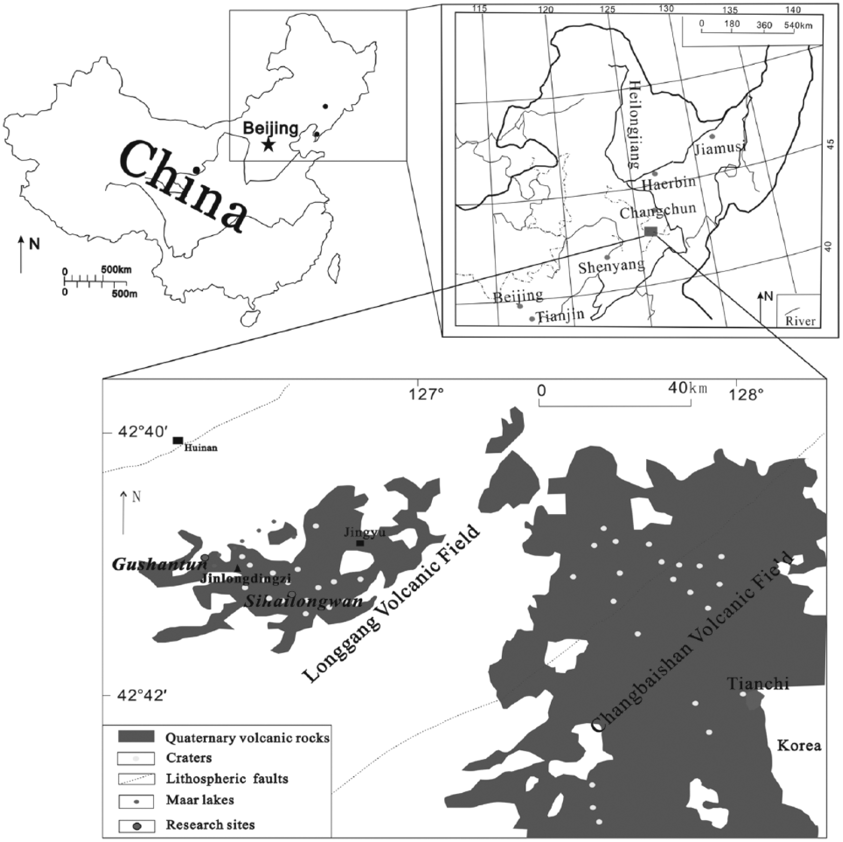
Map of research area.
The modern climate of Northeastern China is controlled by the East Asian monsoonal system which shows a strong seasonal variability, and whose wind direction may have an influence on tephra distribution. Dominating north-westerly winds in winter contribute aeolian material from the interior of the Eurasian land mass to the Sihailongwan sediments (Chu et al., 2005). In contrast, summers are dominated by humid air masses transported by south-easterly winds from the Pacific (Figure 2).

Overview map showing the different dominant wind directions (Schettler et al., 2006a).
There are many bogs and maar lakes in the Longgang region (42°N, 126°E). Gushantun (GST) is a large blanket bog, 1000 m diameter at altitude 500 m a.s.l. and surrounded by a 600 m high plateau. The terrain at GST slopes north/south with a small outlet steam in the southeast that seeps into the bog throughout the year. The Lake Sihailongwan (SHL; 42°17′N, 126°36′E, 791 m a.s.l.) is located 20 km southwest of Jingyu County, Jilin Province (Figure 2) and is one of eight maar and crater lakes in the Longgang Volcanic Field. Lake SHL has no surface outflow and does not receive significant surface inflow from rivulets (Liu et al., 2000; Mingram et al., 2004a; Schettler et al., 2006a, 2006b).
The SHL sediment provides a good setting for research on high-resolution varve chronology and reconstruction of palaeoclimate (Chu et al., 2005; You and Liu, 2006). The samples for this investigation came from the Sino-Germany co-operative drilling campaigns (1998, 1999, 2001). In the present study, through lack of organic carbon in the SHL samples, radiocarbon dates were obtained from published findings of the same core (Liu et al., 2005). For the Gushantun deposit, a chronology was constructed by AMS radiocarbon dating of wood materials by the length of 1 m within sediment. The AMS radiocarbon determinations were performed at the 14Chrono Centre, Queen’s University Belfast.
Methods
Three Sino-Germany co-operative drilling campaigns were conducted in the Longgang volcanic field in late summer of 1998, 1999 and 2001. The basin of Lake SHL is a single circular, simple U-shaped structure. The laminated sediments of the upper 0.5 m are only disturbed by one graded layer which is considered to be the product of an internal slump, and therefore, this lake was chosen for detailed investigations and as a target for deep coring. The SHL sediments are composed of homogeneous, layered and finely laminated diatomaceous gyttja with some intercalations of thick graded single event-layers (Mingram et al., 2004a).
The sediments from the last glacial period, deposited in SHL maar lake, contain a considerable amount of silt and clay; this and a high degree of compaction made it very difficult to pull the core barrels free, so a freeze-coring system (Niederreiter UWITEC, Austria, described in Klee and Schmidt (1987)) was used to obtain undisturbed sediments of the upper layers. Three parallel sediment cores were recovered by the Usinger piston core technique from the centre of the maar lake SHL during a field campaign in summer 2001. This is the deepest lake cored so far with a Usinger-corer (the water depth at the coring point is 49 m; Mingram et al., 2004b). Overlapping 2-m drives from a total of the three adjacent coring sites at the centre of the lake basin enables us to establish continuous composite profiles. The outer parts of the core were carefully removed to avoid possible contaminations from the steel core tubes that may have occurred during storage and transport to the GeoForschungsZentrum Potsdam (GFZ) laboratories. Continuous cooling of the sediments was used from the field to the laboratory.
By aligning minerogenic layers and tephra layers, three composite profiles of lake sediments have been constructed. In this study, the sediment samples for geochemical and sedimentological investigations are from composite profile II and at 10 cm resolution and re-analysed at 1 cm within the tephra layers. This profile has a depth of 2321 cm, and the sediments of the upper 1000 cm were used in this study (Figure 3).
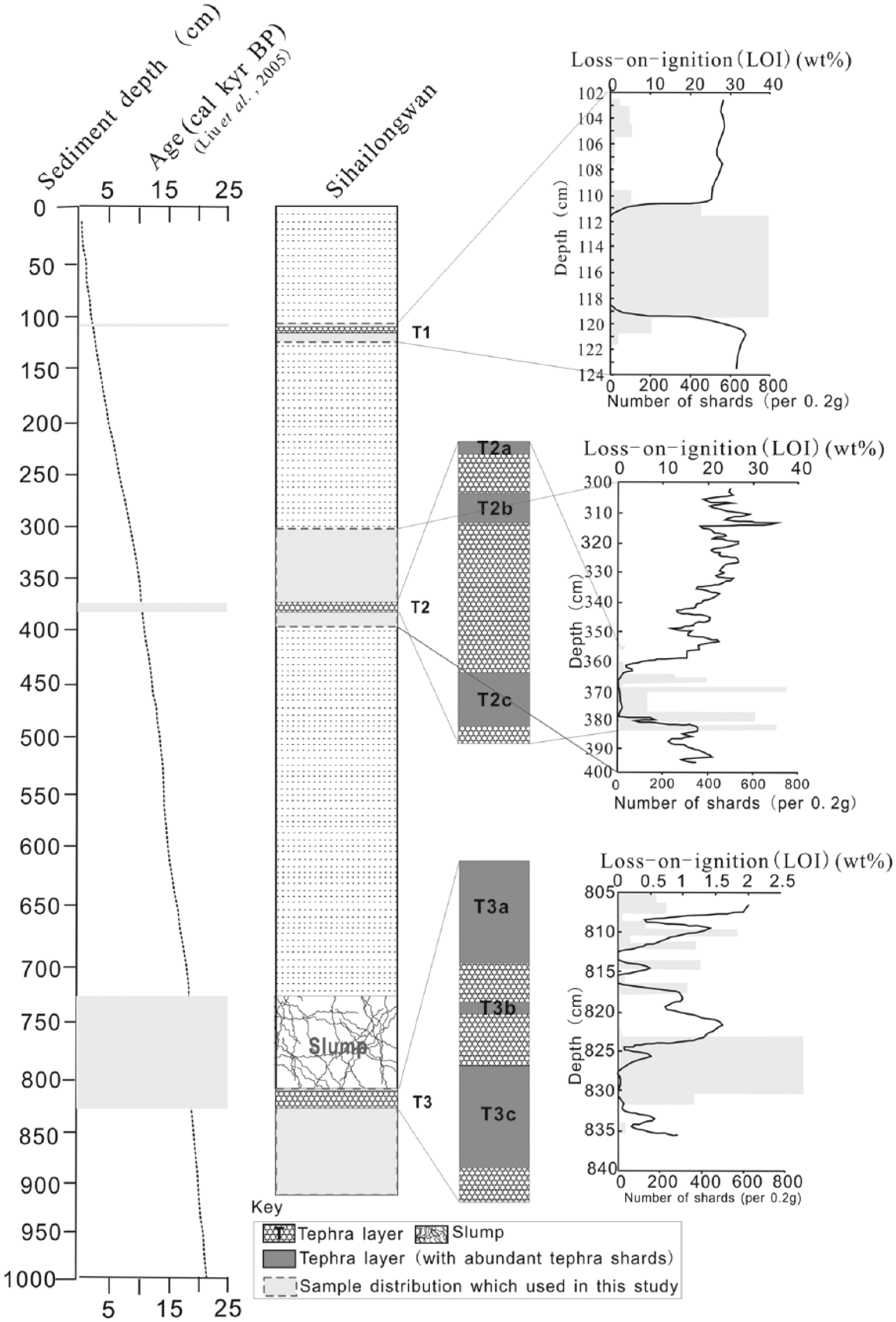
Age–depth model and stratigraphy for Sihailongwan sediment.
The Gushantun core was obtained using a D-section corer as described by Jowsey (1966), and the depth sampled was 673 cm. The stratigraphy is presented in Figure 4 showing the lithologic character of Gushantun core: 0–58 cm – Tan sedge with many grass roots at the top give way at 58–240 cm to brownish-black peat with some plant residue. From 240 to 609 cm, a black peat with high organic matter content overlines 609–628 cm of brownish-black argillaceous peat, and then from 628 to 673 cm occurs silt with peat.

Gushantun stratigraphic diagram. In the yellow section, four rhyolitic shards were detected.
Laboratory procedures for the determination of loss-on-ignition (LOI) and extraction of cryptotephra from the SHL and GST deposits follow the ashing method of Pilcher and Hall (1992), and for electron microprobe analysis, the density separation technique for minerogenic sediments developed by Turney (1998). Samples from GST and SHL were first analysed under polarised light at 400× magnification using an Olympus BH-2 microscope. Samples for precise wavelength dispersive electron microprobe analysis were prepared using the method described in Hall and Pilcher (2002) and Turney (1998) and performed on the JEOL FEGSEM 6500F (Coulter et al., 2009) at Queen’s University Belfast. Operating conditions were 15 kV, 20 nA with raster beam current 5 µm.
Results
Light microscope analyses
The copious shards detected from SHL (Figure 5) are large and frequently over 100 µm in length, typically light brown to dark brown and with bubbles; no rhyolitic shards were detected. Three visible tephra layers were detected in the sediment (see also Liu et al., 2005, 2009; Stebich et al., 2007). Within the three visible tephra layers, the distribution of tephra shards was not uniform in layers T2 and T3, and cryptotephra sublayers were both detected in the two layers. Layer T1 has a 6 cm thickness, and the maximal tephra concentration occurs well within the lowest LOI values. Layer T2 has a 19 cm thickness, with tephra shards concentrated between 364.5 and 365.5 cm, 367.5 and 369.5 cm and between 377.5 and 380.5 cm and associated with slightly lower LOI values in the sequence. In layer T3, 29 cm thickness, tephra shards were concentrated between 806.5 and 812.5 cm, 816.5 and 817.5 cm and between 823.5 and 832.5 cm, where LOI values showed some variability (Figure 3). Four colourless, bubbly tephra shards, 90–100 µm in size, were detected in GST at 40–43 cm depth (Figure 6).

Photographs of volcanic ash from Sihailongwan.

Photographs of volcanic ash from Gushantun.
Geochemical analyses
Sihailongwan
The results from wavelength dispersive electron microprobe analysis of the tephra layers in the SHL sediment are as follows (Table a, included in the supplementary file, available online). Published major element compositions (wt%; Fan et al., 1999; Liu et al., 2009; Yu et al., 2003) of the one eruption of Jinlongdingzi showed that SiO2 varies from 46.8% to 49.8%, Na2O from 3.5% to 4.2% and K2O from 2.0% to 2.7% (Table 1; as published data had not been normalised, that practice was not followed in this study).
1. SHL T1-Jinlongdingzi, SHL T2-Jinlongdingzi, SHL T3-Jinlongdingzi.
Published geochemical composition of tephra shards from Jinlongdingzi. The values are expressed as percentages of total oxides.

Separate volcanic ash geochemistry comparison between SHL T1, T2, T3 and tephras from an outcrop on Jinlongdingzi volcano are as follows (Figures 7 and 8). Biplot of SiO2% and Al2O3%: SiO2% varies from 47.6% to 48.0%, and Al2O3% varies from 15.6% to 17.2% for SHL_A2u 63-64 in Figure 7b. SiO2% and Al2O3% for SHL_A2u 66-68 vary from 47.5% to 48.2% and 15% to 17.4%, respectively. For sample SHL_A2u 76-79, SiO2% and Al2O3% vary from 49% to 51.1% and 16.1% to 17.2%, respectively, in turn. It shows that T2a and T2b trend similarly with Jinlongdingzi volcanic ash and slightly lower SiO2 than T2c. Biplot of FeO% and TiO2%: FeO-TiO2% biplot showed the wider spread for three sublayers in T2 and Jinlongdingzi, but they all have a similar trend in Figure 7c. Biplot of SiO2% and Al2O3%: most T3a and T3c samples clustered and SiO2% varies from 47.9 to 48.7% and Al2O3% varies from 15.4% to 16%. There is a slightly higher SiO2 and lower Al2O3 in comparison with volcanic ash from the Jinlongdingzi outcrop (SiO2%: 46.4–49.8%; Al2O3%: 15.9–17.6%) in Figure 7d. Biplot of FeO% and TiO2%: T3a and T3c have similar composition for FeO% and TiO2%, and T3b and Jinlongdingzi shards have a wider compositional spread in Figure 7e.
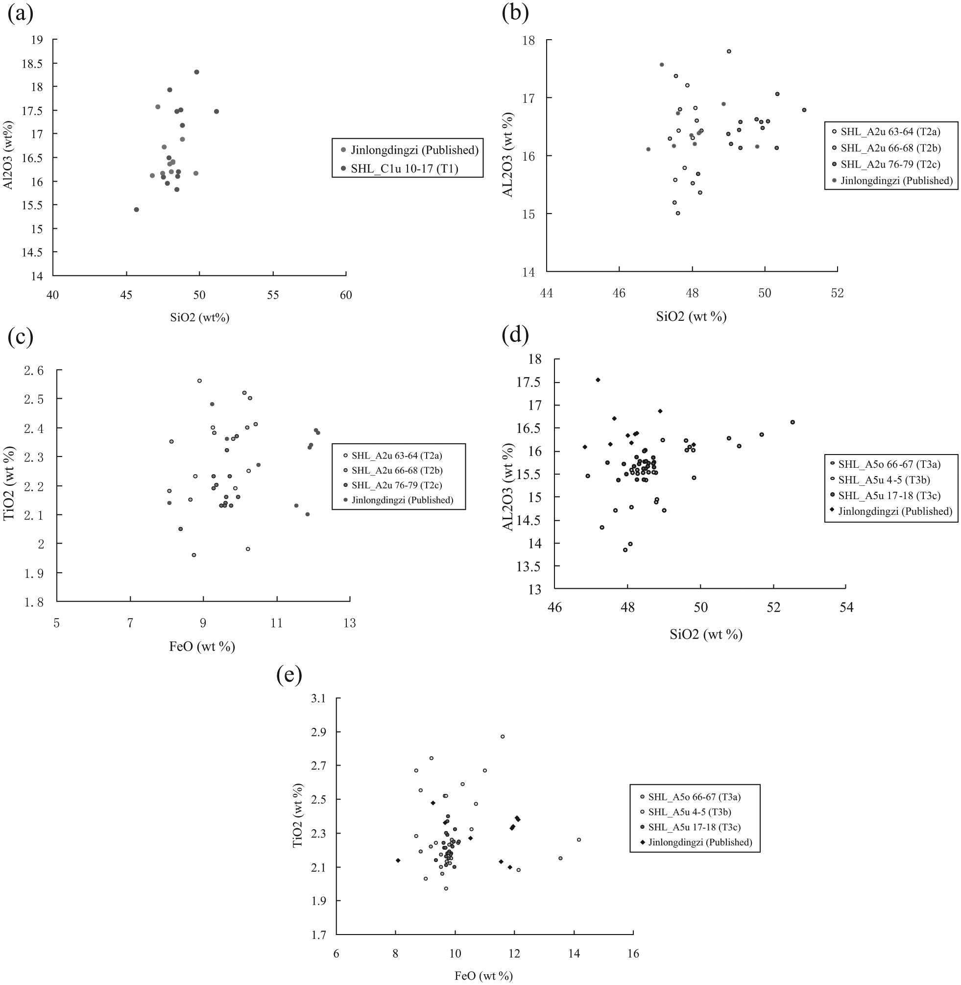
Biplots for geochemical characteristic comparison between SHL T1-Jinlongdingzi, SHL T2-Jinlongdingzi and SHL T3-Jinlongdingzi. (a) SiO2-Al2O3 (wt%), SHL T1-Jinlongdingzi; (b) SiO2-Al2O3 (wt%), SHL T2-Jinlongdingzi; (c) FeO-TiO2 (wt%), SHL T2-Jinlongdingzi; (d) SiO2-Al2O3 (wt%), SHL T3-Jinlongdingzi; and (e) FeO-TiO2 (wt%), SHL T3-Jinlongdingzi.

Classification of volcanic ash from Jinlongdingzi outcrop and SHL T1, T2, T3 based on the total alkalis-silica (TAS) – plot provided by Le Maitre et al. (2002).
Most tephras from T1 of SHL are trachybasaltic and are similar to Jinlongdingzi in the outcrop from Figure 8, although there are still some within the tephrite and basaltic trachyandesite. Samples from SHL tephra layer 2 are trachybasalt. T2a and T2b overlap with volcanic ash from Jinlongdingzi. Although T2c is slightly separate, it is still trachybasalt. Most volcanic ash from three sublayers of T3 is derived from trachybasaltic lava (Figure 8).
2. SHL T1, T,2, T3-Jilongdingzi.
Tephra geochemistry comparison of three tephra layers and cryptotephra sublayers in the SHL deposit (Figure 9) showed that geochemical composition based on FeO-CaO-K2O is similar for three tephra layers and Jinlongdingzi, with a wider compositional spread for shards from T3b.
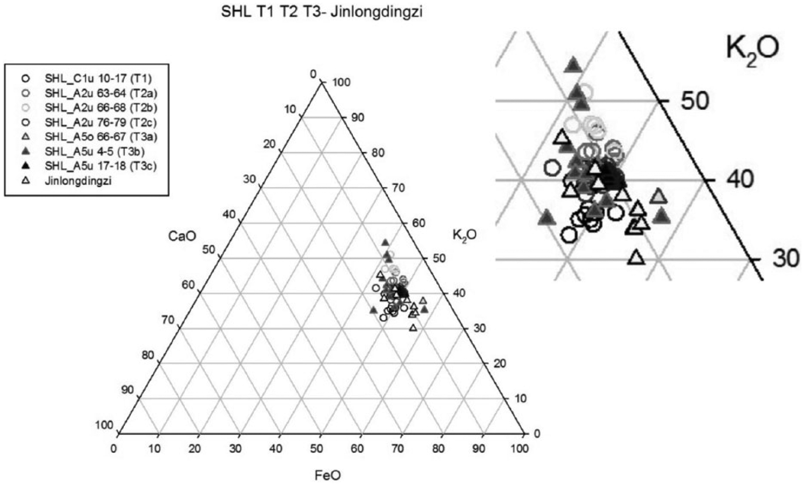
Ternary diagram showing the relative proportion of FeO, CaO, K2O (%) for three tephra layers and cryptotephra sublayers within SHL and Jinlongdingzi outcrop. Geochemical composition based on FeO-CaO-K2O is similar for three tephra layers and Jinlongdingzi, just a wider compositional spread for shards from T3b.
Gushantun
Four colourless rhyolitic shards were found in the GST peat at 40–43 cm and were 90–100 µm in length. Comparisons have been made between the analyses of tephra shards in the GST peat presented with those from Machida et al. (1990), Guo and Wang (2002) and the published data from Longgang area (Figure 10, Table 2).

Classification of tephra from Gushantun, Tianchi volcano and Longgang based on the total alkalis-silica (TAS) plot provided by Le Maitre et al. (2002).
Geochemical composition of tephra shards in sediment from Gushantun (GST) with published data of Tianchi (wt%).
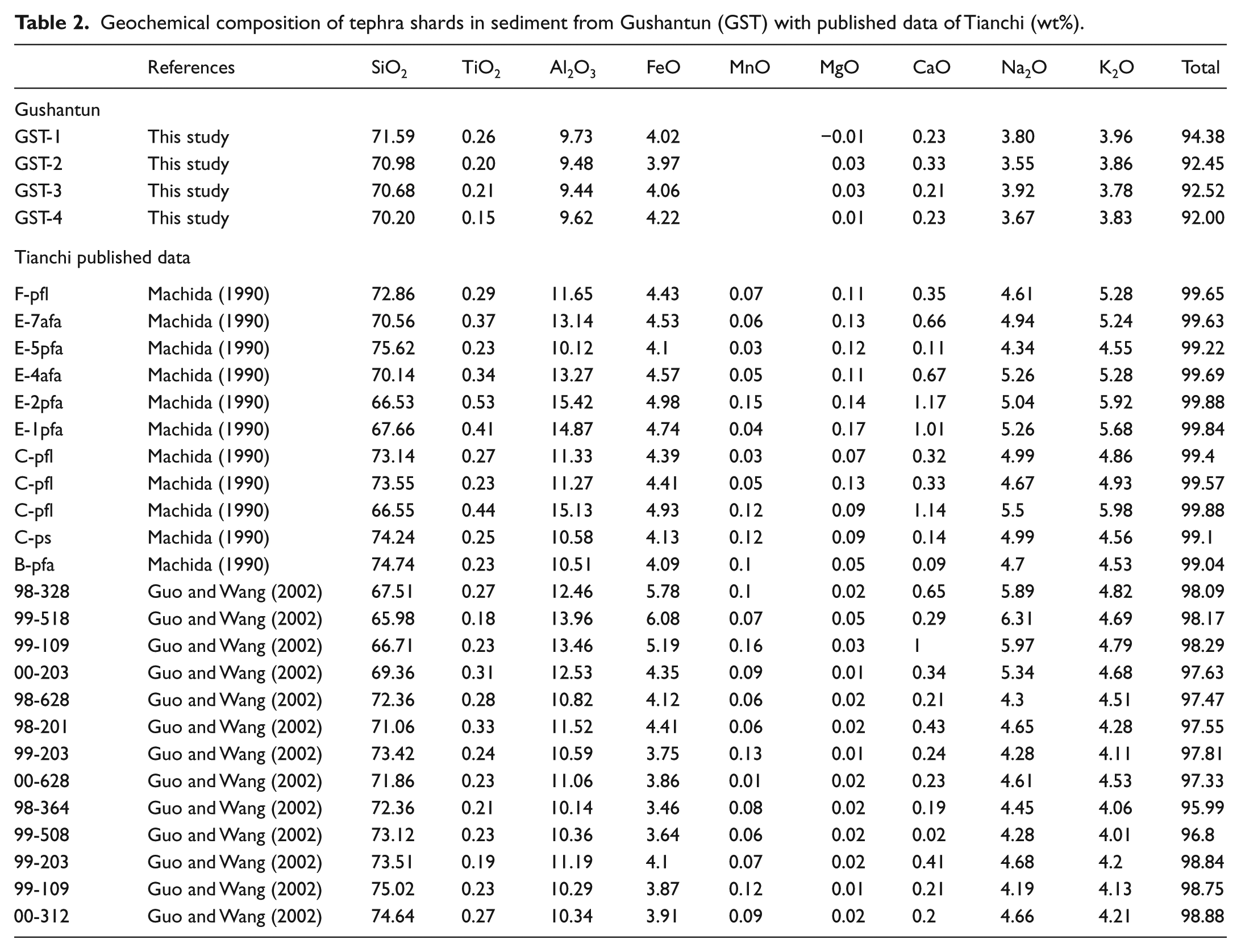
It is obvious that the tephra shards detected in GST show similarity with those from the Tianchi eruption and may differ from Jinlongdingzi. The geochemical characteristics of the Jinlongdingzi and Tianchi tephras show marked dissimilarities (Figure 10).
Chronology construction
The chronology for this study is constructed from published studies and new data from this study. The tephra samples from SHL in this study contained so little carbon that they were unsuitable for radiocarbon dating; therefore, no new radiocarbon data were obtained from SHL. Sixteen AMS radiocarbon from published findings (Liu et al., 2005) were used to construct the chronology for this site (the samples from the same core with samples in this study; Table 3). At GST, nine wood samples taken at approximately 100 cm intervals along the depth of the core were used for chronology construction (Table 4).
AMS 14C data from composite profile II of the Sihailongwan Maar Lake (data from Liu et al., 2005).
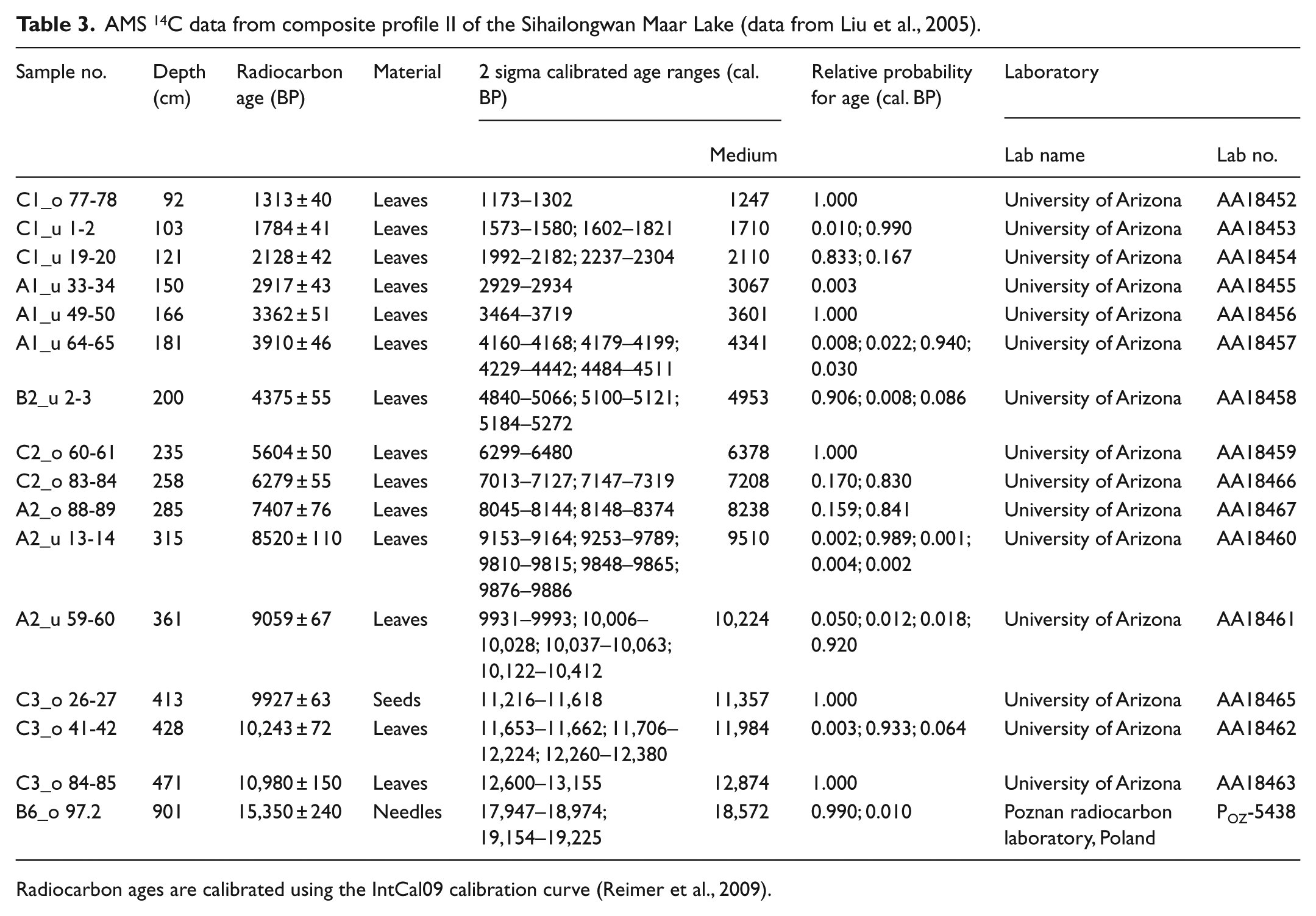
Radiocarbon ages are calibrated using the IntCal09 calibration curve (Reimer et al., 2009).
AMS 14C data from Gushantun (GST).
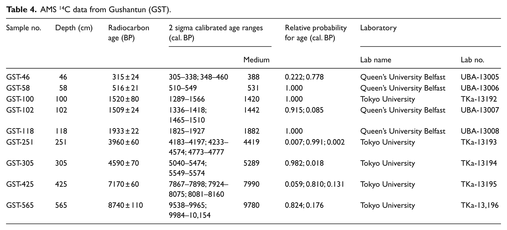
All radiocarbon ages are calibrated using the IntCal09 calibration curve (Reimer et al., 2009). The polynomial line-fitting age–depth model (y = a + bx + cx2 + dx3) was used to estimate the ages at the different depths. According to AMS 14C dating, the ages for three tephra layers in SHL sediments are T1 1710–2110 cal. BP, T2 10,250–10,700 cal. BP and T3 17,000–18,500 cal. BP. Liu et al. (2009) through varve chronology reveal that three basaltic explosive eruptions of Jinlongdingzi occurred at AD 460 (1600 cal. BP, 11,460 cal. BP and 14,000 cal. BP). The most recent basaltic eruption (AD 460) can be observed in the outcrops and lake deposits, which combined with the dating showed that T1 was produced by the most recent eruption of Jinlongdingzi volcano. The age of GST tephra is 260–420 cal. BP, and combined with the geochemical characteristics, this eruption fits the historic Tianchi eruptions happened in AD 1702, 1668 and 1597; however, because of the very similar geochemistry of these three eruptions (Liu, 1999), it is hard to say where GST tephra layer came from and the eruption source needs further investigation.
Discussion
The Changbaishan area of active volcanism is known to have been the source of tephrogenic volcanic activity in the past. Tianchi and Jinlongdingzi are two volcanoes located in the Changbaishan Volcanic Field and Longgang Volcanic Field, respectively. Both of these volcanoes have had explosive eruptions during the late Quaternary. The Jinlongdingzi Volcano erupted several times and all were confirmed as basaltic magma eruptions, while Tianchi volcanic eruptions were rhyolitic in nature. These two volcanoes may pose potential hazards in the future.
The few, possibly airfall, rhyolitic shards found in the GST peat are considered to have come from a Tianchi eruption. The Tianchi Volcano is one of the largest, most active and dangerous volcanoes in the world. Documentary evidence records that the Tianchi Volcano erupted many times during the past 1000 years, the largest eruption having occurred in AD 1199–1200 (Cui et al., 2000), with ash widely distributed in a layer more than 20 cm thick some 50 km from the Tianchi crater. The tephra shards found in GST were all thin-walled and bubbly; there are no totals above 95% obtained, and so further analyses were impossible. There is no record of rhyolitic volcanism in the Longgang Volcanic Field, and this prompted the search for a possible volcanic source for the poorly represented rhyolitic tephra layer at GST. The published data from Machida et al. (1990) and Guo and Wang (2002) described the geochemical characteristics of the volcanic ash from the Tianchi millennium eruption. The data presented in this study indicate that products from one of Tianchi eruptions could have reached GST (200 km distant from the Tianchi Volcano). A major tephra layer from the Tianchi millennium eruption has been found in Japan and the Sea of Japan. It appears that the direction of the prevailing wind biased against a western distribution (Guo et al., 2005), but ash may be transported against the prevailing wind flow, for example, as reported in Nelson et al. (1986), Mortensen et al. (2005) and Shane (2000).
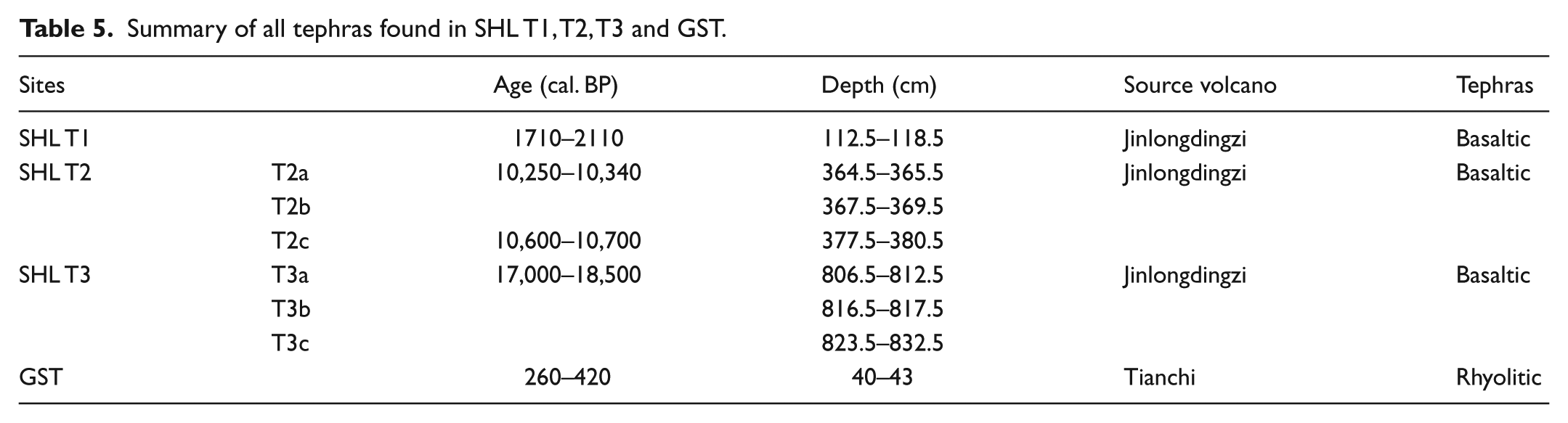
The Jinlongdingzi volcano had several eruptions in the past 15,000 years (Liu et al., 2009); it is the nearest volcano to SHL. Sihailongwan tephras appear to be airfall tephra, and when compared with shards from Jinlongdingzi outcrop, all showed similar geochemical characteristics. Jinlongdingzi Quaternary eruptions all appear to have similar geochemistry. Tephra shards from the eruption of Jinlongdingzi in 17,000–18,500 cal. BP were deposited in Sihailongwan. About 7000 years after this eruption, another occurred around 10,250–10,700 cal. BP. Its tephra shards also appear to be deposited in the SHL sediment and are well preserved. This tephra unit showed a significant gap between the cryptotephra sublayers and although with similar geochemistry, radiocarbon age determinations showed a 500 year spread, implying perhaps two eruption events, one in about 10,600–10,700 cal. BP and the other in 10,250–10,340 cal. BP. Because of sample limitations, no such tephra shards were detected in GST. A successor eruption of Jinlongdingzi occurred in 1500–2100 cal. BP. Tephra shards were deposited and were well preserved in SHL sediments, but none were found in GST, possibly because of the contrasting environmental conditions and taphonomy for tephra preservation in lake sediment and peats (Table 5).
Summary of all tephras found in SHL T1, T2, T3 and GST.
A powerful method of establishing precise correlations between local and distal records can be provided by the identification and geochemical characterisation of tephra layers within Quaternary sediments. Past environment reconstruction is hampered by the dearth of long continuous and high-resolution records of environmental change in the Changbaishan area. Tephrochronology has great potential to develop accurate and precise links between site stratigraphies. So, if more tephra and cryptotephra shards from Tianchi eruption or Jinlongdingzi eruptions are discovered in the sediments of Northeastern China, a firm tephrochronology and tephrostratigraphy framework can be established to provide the time basis for stratigraphic comparison and trace the history of eruptive volcanism. Moreover, the use of multi-dating methods could provide precise and higher resolution time scale for past global changes.
Conclusion
Few rhyolitic cryptotephras found in the GST peat and three tephra layers and sublayers were detected in SHL are considered to have come from Tianchi volcano eruption and Jinlongdingzi volcano eruption, respectively. A powerful method of establishing precise correlations between local and distal records can be provided by the identification and geochemical characteristics of tephra layers within Quaternary sediments.
Footnotes
Acknowledgements
Thanks to Professor Paula Reimer and Dr Maarten Blaauw, Queen’s University Belfast, UK, for their help in calibrating radiocarbon dates, and to Professor Liu Jiaqi and Dr Liu Qiang, from the Institute of Geology and Geophysics, CAS, in site selection and sample collection. Many thanks to Professor John Dodson, from Australian Nuclear Science and Technology Organisation (ANSTO), for his thoughtful reviews and comments.
Funding
This study was supported by the National Natural Science Foundation of China (Grant no. 41202260) and Overseas Research Scholarship (UK, 2007–2010).