
Abstract
This is a detailed tephrostratigraphical investigation of late Quaternary deposits in the Longgang and Changbaishan Volcanic Fields of northeastern China. A total of 45 reference samples which were collected from either side of the Chinese/Korean border showed very similar geochemical characteristics to the Millennium eruption of Tianchi Volcano. Through comparing the published data of the glass shards detected in Gushantun with these reference samples, further description is that the glass shards in the sediment of Gushantun came from the Tianchi Volcano eruption in AD 1702, 1668, and 1597. A basaltic tephra layer found in the sediment of Hanlongwan associated with an eruption of the Jinlongdingzi Volcano which happened in 1500–2100 cal. yr BP by comparing with the published data from Sihailongwan and Xiaolongwan. Tianchi and Jinlongdingzi Volcano are both active and erupted several times during the historical period. Reference samples and the tephra layers detected in Hanlongwan, Sihailongwan, Gushantun, Erlongwan, and Xiaolongwan can be used as marker horizons beyond the Longgang Volcanic Field and Changbaishan Volcanic Field, including, for example, in Japan, Korea, nearby coastal area of Russia, and marine records.
Introduction
Quaternary reconstructions are often hindered by poor chronologies (e.g. Shulmeister et al., 2004). Traditional dating methods sometimes lack the precision required to test the spatial synchroneity of environmental and archaeological change. Tephra as a chronology tool depends, of course, on knowing when the eruption took place and then linking a tephra fall to a particular eruption.
Linking sites using geochemical tephrostratigraphy is valuable, but where this can be expanded into tephrochronology, it serves Quaternary studies well, especially if dating precision of sites can be improved. Volcanic ash can be dated (Cheng et al., 2008; Guo and Wang, 2002), but it is much more common to date the profile using, for example, varves if working on suitable lake sites or the organic material associated with the tephra layer in lake sediment or peat profile (Chu et al., 2005; Liu et al., 2009; Parplies et al., 2008). This approach needs a good understanding of the potential and limits of precision for varve and radiocarbon dating.
The potential of varves as a basis for dating was initially recognized by the Swedish geologist Gerard de Geer who, in 1884, made the first attempt to count and correlate varve sequences in the Stockholm area of Sweden. Because the sediment is deposited annually, varves form a basis for dating; by counting varve sequences, time intervals can be established. If varve series can be dated by radiocarbon dating of included organic materials, then the varve-chronology can be linked to the calendar timescale.
Hogg et al. (1987) and Froggatt and Lowe (1990) summarized that the use of organic materials found in association with tephra deposits for 14C dating has been widely employed in developing the chronology of the most recent rhyolitic eruptions of the Taupo, Okataina, Maroa, and Mayor Island centers. Although material carbonized during the emplacement of the tephra provides the best material for chronology, it is not always available. Many ages are based on organic material interbedded with the tephra in peat bogs and lakes (e.g. Lowe, 1988). Such ages may not precisely reflect the time of the eruption and are prone to contamination. However, peat and lake sequences do provide a near-continuous depositional record that commonly contains multi-sourced tephra beds that allow chronologic relationships to be established (e.g. Hogg et al., 1987; Lowe, 1988). There is a great potential accuracy and precision for dating tephra in the 14C range.
Annually laminated sediments of Quaternary age have been recognized at widespread geographic locations (Anderson and Dean, 1988; Lamoureaux, 1999; Larsen and Stalsberg, 2004; O’Sullivan, 1983; Overpeck, 1996; Smith et al., 2004; Zolitschka, 1996), but, until recently, only a few laminated sediment records have been found in China. Such laminated sediments are often preserved in maar lakes (Zolitschka et al., 2000). Quite recently, several varved sequences have been recovered from the maar and crater lakes of the Longgang Volcanic Field (LVF). These successions provide long, detailed palaeoecological and palaeoclimatic records with excellent temporal controls (Mingram et al., 2004a). In addition, they are located in an area that is frequently impacted by volcanic ash deposition.
The tephra layer is widely distributed in Northeastern China, Japan, North Korea, and part of Russia. Guo et al. (2005) pointed out that Tianchi tephra was found in the sediment of Sihailongwan (SHL) and that probably shows that the products erupted from Tianchi Volcano in AD 1199–1200 reached the LVF. A tephra layer 4–6 cm thick in the islands of north Japan has also been recognized as coming from the Millennium eruption of Tianchi Volcano (Machida, 1999; Machida and Arai, 1992). One tephra layer originating from Tianchi Millennium eruption is found on the east side of Kutcharo caldera, in the coastal areas of eastern Hokkaido, in the tsunami sediments at Asahidake volcano in the middle of Hokkaido, and in the area of Tyatya volcano in the southwestern Kuril Island Arc (Sun et al., 2014b). Sun et al. (2014a) reported that the ash from Changbaishan Millennium eruption was recorded in Greenland ice cores.
In this paper, we use the detailed analysis from reference samples of Tianchi Volcano and sites Hanlongwan (HLW), Sihailongwan (SHL), and Gushantun (GST) age–depth model, and dating carbon-based material found in association with the volcanic ash, along with accurate historical records for the eruptions, produces dates for the tephra layers the site contains. There were three tephra layers and sub-layers detected in the sediment of SHL (Zhao and Hall, 2015); one tephra layer was found in HLW (this study) and few tephra shards were detected in GST (Zhao et al., 2015). Furthermore, there were also some tephra layers discovered in the sediments of Erlongwan (ERL; Frank, 2007) and Xiaolongwan (XIA; Liu et al., 2009). Detailed descriptions and correlations of these tephra layers with the data of reference samples of Tianchi Volcano (this study) are presented in the following sections (Figure 1, Table 2). These tephra layers provide accurate temporal marker layers which can be used to verify or corroborate other dating techniques. By linking sequences widely separated by location into a unified chronology, the tephra layers can correlate climatic sequences and events to assess major volcanism in the late Quaternary of the Changbaishan area.
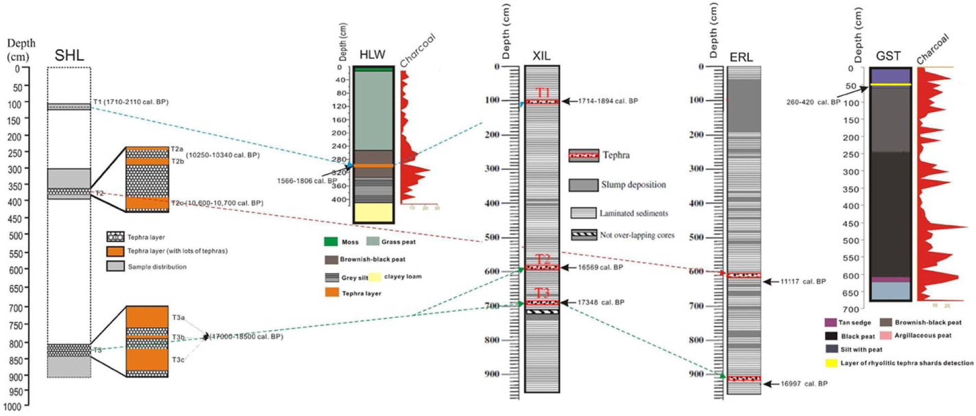
Stratigraphy of tephra layers in five lake and peat profiles. Stratigraphy of Lake SHL, Lake HLW, and peat bog GST from this study; Lake XIL from Liu et al. (2009); Lake ERL from Frank (2007).
Study area
Northeastern China and NE Korea are the regions of active volcanism because of its reasonably well-understood record of Quaternary volcanism (Liu, 1999). It was also thought suitable to advance tephra studies through researching cryptotephra studies in maar lake deposits. In addition, this volcanically active region has a population of 8.7 million people. A better understanding of the chronology of the region’s volcanic history would benefit this community through volcanic risk assessment.
The modern climate of Northeastern China is controlled by the East Asian monsoonal system which shows a strong seasonal variability. Winter seasons are very cold and dry with dominating north-westerly wind directions contributing a substantial amount of aeolian material from the interior of the Eurasian land mass, including to SHL sediments (Chu et al., 2005). Summers are warm and dominated by humid air masses transported by south-easterly winds from the Pacific.
Changbaishan and Longgang are two volcanic fields in the Changbaishan area, Northeastern China (Figure 2). The Changbaishan Volcanic Field (CVF) crosses the boundary between China and Korea. It is located at 41–42.5° latitude north and 127–129° longitude east. In the CVF, the Tianchi Volcano is one of the largest, most active, and dangerous volcanoes in the world (Liu, 1999). It consists of hundreds of volcanic cones, reaches a height of 2755 m a.s.l., and comprises about 12 × 103 km2 of volcanic rock. Documentary evidence records that the Tianchi Volcano erupted many times during the past 1000 years. A huge eruption occurred in AD 1199–1200 (Cui et al., 2000). During that time, huge amounts of gray-white pantelleritic tephra widely distributed thick layers some 50 km from the Tianchi crater. Since the big eruption of Tianchi in AD 1199–1200 (Cui et al., 2000), historical documents indicate that this volcano erupted in AD 1413, 1597, 1668, 1702 (Wang, 1989), and 1900 (Xu et al., 1993). Tianchi Volcano is still a high-risk volcano (Liu et al., 1992a, 1992b, 1998) and represents a centered zone for the eruption of basaltic magma in the region since late Cenozoic time.

Schematic maps of the research area (modified from Zhao and Hall (2015)).
Adjacent to the CVF, just 200 km to the west, lies the LVF. It covers 1700 km2 and has more than 160 craters and calderas of Quaternary age (Liao, 1990; Liu, 1999; Ou and Fu, 1984). Jinlongdingzi Volcano is the youngest and it represents the most recent volcanic activity in LVF. The AD 460 eruption of Jinlongdingzi, dated by varve-chronology, was identified as the region’s most recent explosive basaltic eruption (Liu et al., 2009). During the past 15,000 years, Jinlongdingzi Volcano erupted several times and has been confirmed as basaltic magma eruptions (Fan et al., 1999, 2000, 2002; Liu et al., 2009). The present regional topography of the LVF was shaped mainly in late Pliocene to early Pleistocene times because of westward subduction of the West Pacific plate and associated volcanic activity (Liu, 1999). Eight maar lakes were formed in the west of LVF (Liu, 1999): XIA, ERL, Dalongwan (DAL), Sanjiaolongwan (SJL), Donglongwan (DOLO), Nanlongwan (NAL), Longquanlongwan (LQL), and SHL (Figure 2).
Sediments from GST, HLW, and SHL were selected for this study. GST is one of several large blanket bogs (42°N, 126°E, altitude: 500 m a.s.l.) with a diameter of about 1 km. It is surrounded by a 600-m-high basaltic plateau and is thus well placed to preserve tephra fallout. The terrain at GST slopes from north to south with a small outlet steam in the southeast that seeps into the bog throughout the year. HLW is a dry maar lake. It is almost circular, the lake floor is located at ca. 700 m a.s.l., and it has a surface area of 0.85 km2. The relative height of the tuff ring around the maar is about 10 m, and it is made up mostly of basaltic fulgurite. Lake SHL (42°17′N, 126°36′E, 791 m a.s.l.) is located 20 km southwest of Jingyu County, Jilin Province (Figure 2), and is one of eight maar and crater lakes in the LVF. SHL has no surface outflow and does not receive significant surface inflow from rivulets (Liu et al., 2000; Mingram et al., 2004; Schettler et al., 2006a, 2006b).
Methods
Field work and lithology
CVF
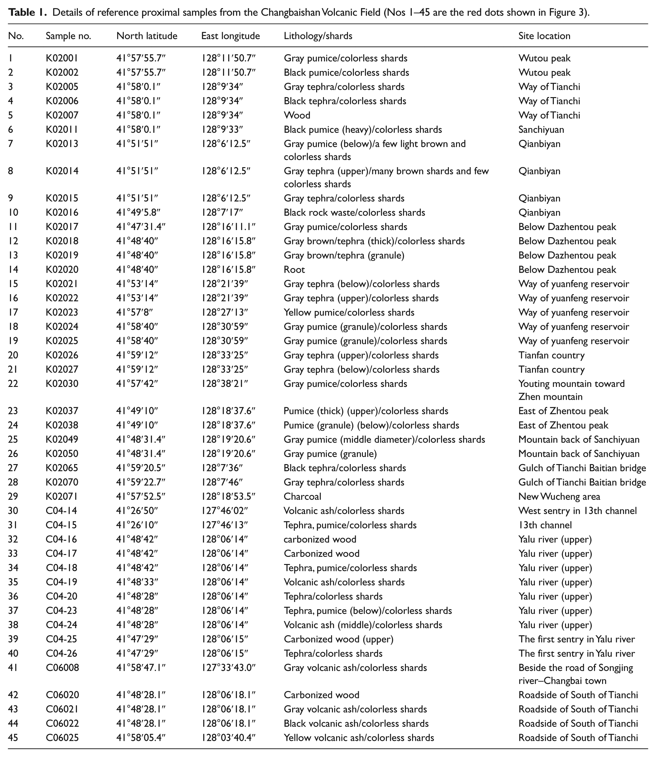
A total of 45 reference samples were collected from the field in CVF in 2002, 2004, and 2006. Samples were taken mainly from proximal to medial–distal Plinian fallout and pyroclastic flow deposits on the eastern and southeastern flank of the Tianchi crater, lying on either side of the Chinese/Korean border (Figure 3, Table 1). These tephra reference samples were considered to drive from eruptions of the Tianchi Volcano and represent valuable correlatives for the comparison with potential distal tephra findings in deposits at SHL, GST, or HLW.

Proximal and medial–distal tephra sampling sites (red dots) with sample codes from the Changbaishan Volcanic Field.
Details of reference proximal samples from the Changbaishan Volcanic Field (Nos 1–45 are the red dots shown in Figure 3).
LVF
At each study site, we selected a location within the lake basin where a complete sedimentary sequence was anticipated, away from any damage from the initial drilling test and where we could avoid or reduce the influence of the local pollen or areas where perturbation was suspected, such as obvious stream flow.
SHL
As the main coordinator of the SHL coring program, GeoForschungsZentrum (GFZ) Potsdam and with China, co-operative drilling campaigns were conducted in the LVF in late summer of 1998, 1999, and 2001. The basin of Lake SHL has a circular, simple U-shaped structure. The SHL sediments are composed of homogeneous, layered, and finely laminated diatomaceous gyttja with some intercalations of thick graded single event bed (Mingram et al., 2004a).
The sediments from the last glacial period, deposited in SHL maar lake, contain a considerable amount of silt and clay. Three parallel sediment cores were recovered by the Usinger piston core technique from the center of the maar lake SHL during a field campaign in summer 2001. This is the deepest lake cored so far with a Usinger-corer (the water depth at the coring point was 49 m; Mingram et al., 2004b). Overlapping 2-m drives from a total of the three adjacent coring sites at the center of the lake basin enabled us to establish continuous composite profiles. The outer parts of the cores were carefully removed to avoid possible contaminations from the steel core tubes that may have occurred during storage and transport to the GFZ Potsdam laboratories. Continuous cooling of the sediments was used from the field to the laboratory.
By aligning minerogenic layers and tephra layers, three composite profiles of lake sediments have been constructed. In this study, the sediment samples for geochemical and sedimentological investigations are from composite profile II. This profile has a depth of 2321 cm and the sediment of the upper 1000 cm was used for scanning the cryptotephra in this study. We analyzed samples by 10 cm interval and reanalyzed at 1 cm within the tephra layers.
SHL T1 has a wide distribution for most major elements, and some of them overlap with Jinlongdingzi. This tephra layer is 8 cm in thickness. SHL T2 has a thickness of 19 cm and three sub-layers were detected. SHL T3 is 29 cm in thickness; this is the thickest visible tephra layer examined in this study. Most glass shards are between 50 and 100 µm with sharp edges and with bubble inclusions.
GST
GST is a large blanket bog (42°N, 126°E, altitude: 500 m a.s.l.). The GST core was obtained using a D-section corer as described by Jowsey (1966). The samples were then packed in plastic sleeves, sealed with polyethylene thin film, and placed in a hard box for transport to the laboratory. The depth was 673 cm. From the top to the bottom, samples varied from Tan sedge to peat. The stratigraphy is presented in Figure 4 (Zhao et al., 2015).

Gushantun and Hanlongwan stratigraphic diagram (from Zhao et al. (2015b)): (a) Gushantun stratigraphic diagram and (b) Hanlongwan stratigraphic diagram.
HLW
HLW is a dry maar lake. The HLW core was also obtained using a D-section corer as described by Jowsey (1966), and then, the samples were packed in plastic sleeves, sealed with polyethylene thin film, and placed in a hard box for transport to the laboratory. The depth sampled was 443 cm. Samples varied from moss, grass, to clayey loam. The stratigraphy is presented in Figure 4 (Zhao et al., 2015).
Tephra preparation and geochemical analysis
Laboratory procedures for the determination of loss-on-ignition and extraction of cryptotephra from the reference samples and GST, HLW, and SHL deposits follow the ashing method of Pilcher and Hall (1992), and the density separation technique for minerogenic sediments follow the method developed by Turney (1998). Some of the samples were rich in diatoms, whose presence obscured the glass particles during microscopic examination. The diatoms were dissolved in 5% KOH solution (Rose et al., 1994) heated in the water bath at 90°C for an hour and shaken after 30 min. The samples were then processed, following procedures outlined above. Samples were analyzed under polarized light at 400× magnification using an Olympus BH-2 microscope. Samples for wave-length dispersive electron probe microanalysis (WDS-EPMA) were prepared using the method described by Hall and Pilcher (2002) and Turney (1998) and performed on JEOL FEGSEM 6500F (Coulter et al., 2009) at Queen’s University Belfast (QUB). Operating conditions were 15 kV, 20 nA with a raster beam current of 5 µm. Lipari natural glass (Hunt and Hill, 2001) was used as an intermediate standard. Totals of 95% and above for the analysis of the reference samples were retained.
Dating method
The sediments from SHL in this study contained so little carbon that they were unsuitable for radiocarbon dating; therefore, no new radiocarbon data were obtained from SHL. In all, 16 AMS radiocarbon dating from published findings (Liu et al., 2005) were used to construct the chronology for this site (Figure 5).

Sihailongwan profile II age–depth plot (data from Liu et al. (2005)).
Nine and six radiocarbon dates were used to establish the age–depth model for GST and HLW, respectively. Five GST dates and four HLW dates were obtained from Tokyo University, and the others were dated at the 14CHRONO Centre in the School of Archaeology and Palaeoecology, QUB (Zhao et al., 2015). Within the dates of HLW dated in Tokyo University, four samples were of organic material from a range of depths, and one of the other dates dated in QUB was of organic material associated with HLW tephra layer. An age–depth plot is shown in Figure 6.
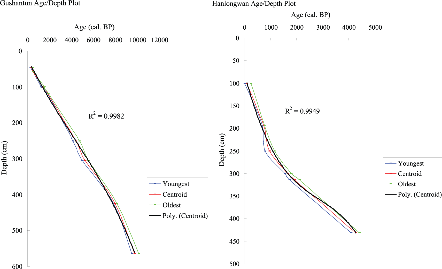
GST and HLW age–depth plot (Zhao et al., 2015b).
All radiocarbon ages are calibrated using the IntCal09 calibration curve (Reimer et al., 2009). The polynomial line-fitting age–depth model (y = a + bx + cx2 + dx3) was used to estimate the ages at the different depths.
Results
Description of tephras
Proximal samples from the CVF
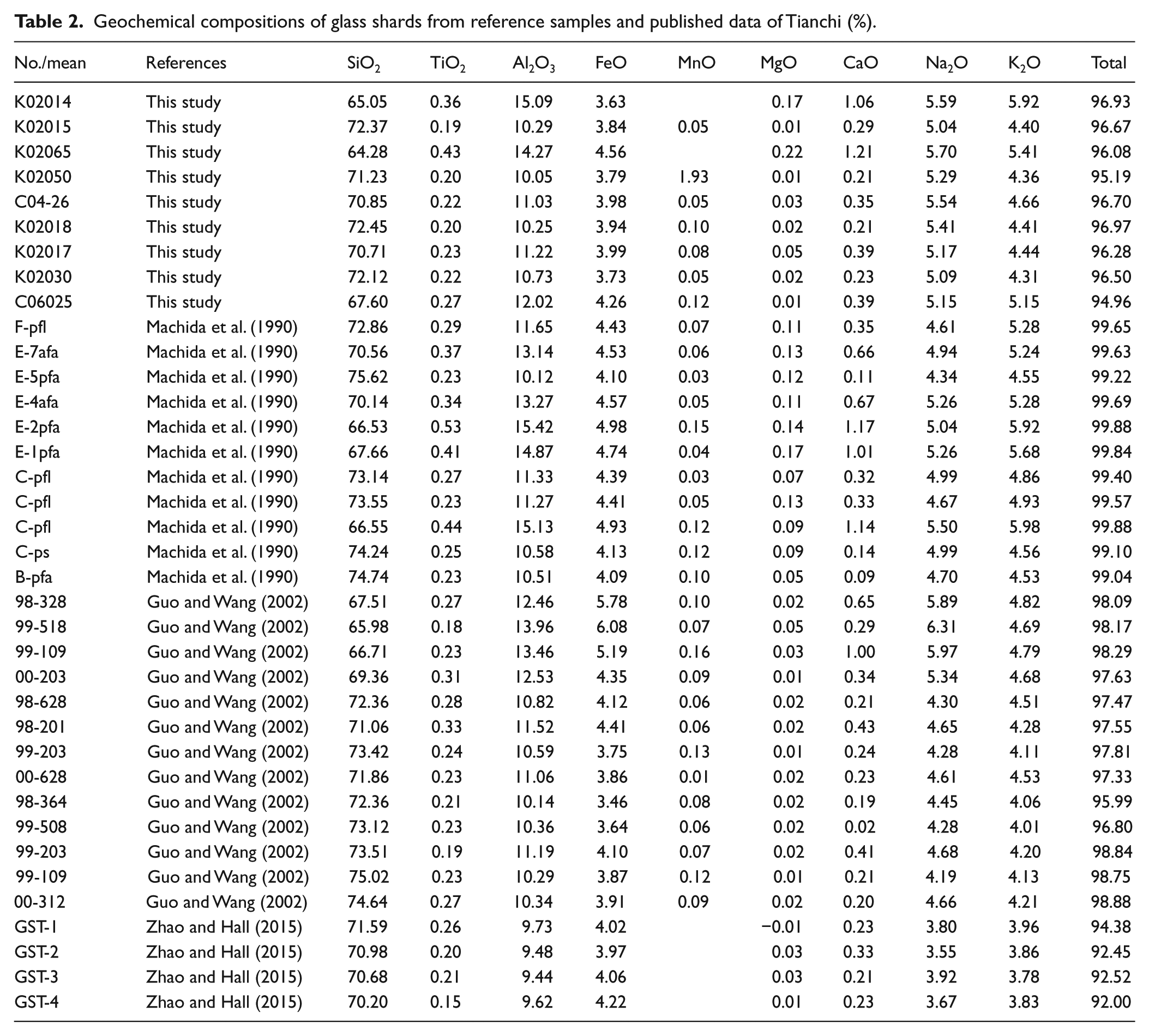
On the basis of shard color, morphology, and vesicularity, nine samples considered characteristic of the range of type material examined were selected for microprobe analysis (Table 2). In total, 10–20 characteristic shards per sample were geochemically analyzed in an attempt to assess the homogeneity of the volcanic glass or to search for evidence of magmatic gradients or magma mixing. Analysis of individual shards of reference samples, except K02014 and K02065, revealed that most rhyolitic tephra shards are compositionally homogeneous and have an overlap with part of the published data. A series of photographs showed representative tephra glass shards from the proximal Tianchi tephra samples (Figure 7).
Geochemical compositions of glass shards from reference samples and published data of Tianchi (%).
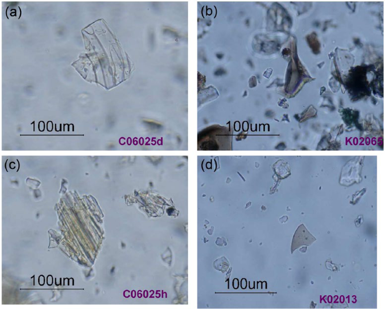
(a) Colorless glass shards, (b) brown shards, (c) yellow shards, and (d) light brown shards from the Tianchi reference samples.
Of the 45 reference samples, C06025 contains a few yellow tephra shards with colorless shards, K02013 contains a few light brown shards with colorless shards, and two tephra samples (K02014 and K02065) originated on the Korean side of the region, which contain many brown shards with few colorless shards. The other type samples were composed only of colorless shards present in huge quantities (Table 1, Figure 3).
LVF
HLW
A 1-cm-thick tephra layer was detected at a depth of 299–300 cm in HLW, and within it, most of the glass shards are brown and large (over 100 µm) with bubbles (Figure 8).
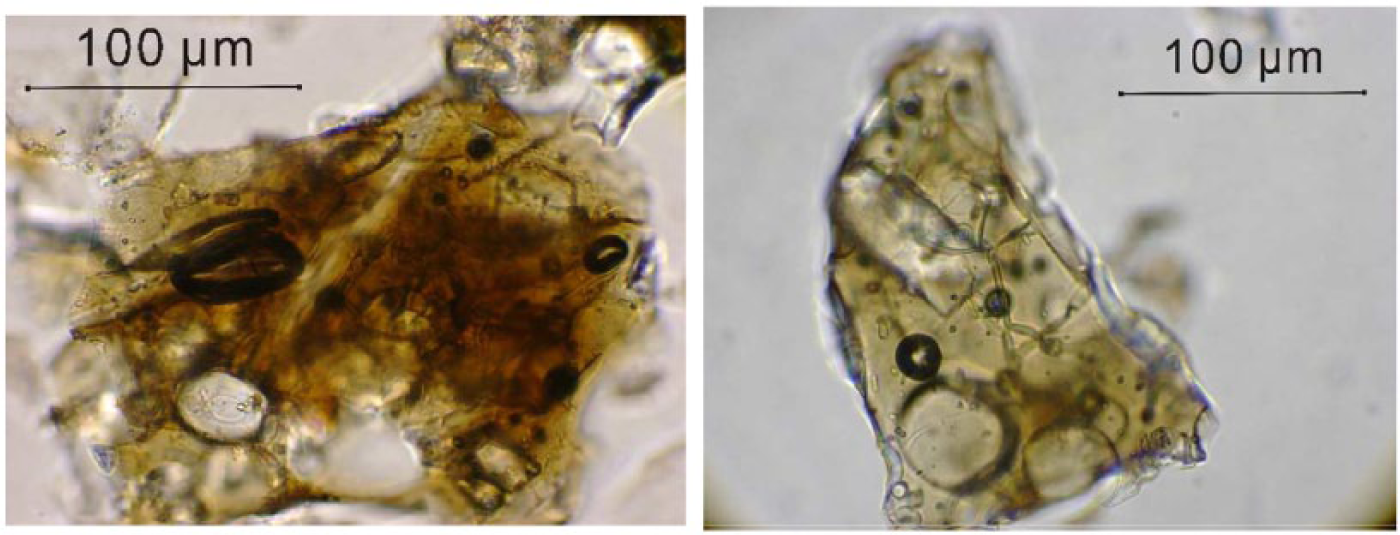
Photographs of glass shards from HLW.
SHL
The copious shards detected from SHL are large and frequently over 100 µm in length, typically light brown to dark brown and with bubbles, but no rhyolitic shards were detected. Three visible tephra layers were detected in the sediment (Liu et al., 2005, 2009; Stebich et al., 2007). Within the three visible tephra layers, the distribution of glass shards was not uniform in layers T2 and T3; cryptotephra sub-layers were detected in the two layers (Zhao and Hall, 2015).
GST
Four colorless, bubbly glass shards, 90–100 µm in size, were detected in GST at 40–43 cm depth. No totals above 95% were obtained. Except few rhyolitic tephras found in Longgang area (Guo et al., 2005), there is no more record of rhyolitic volcanism in the LVF (Zhao and Hall, 2015).
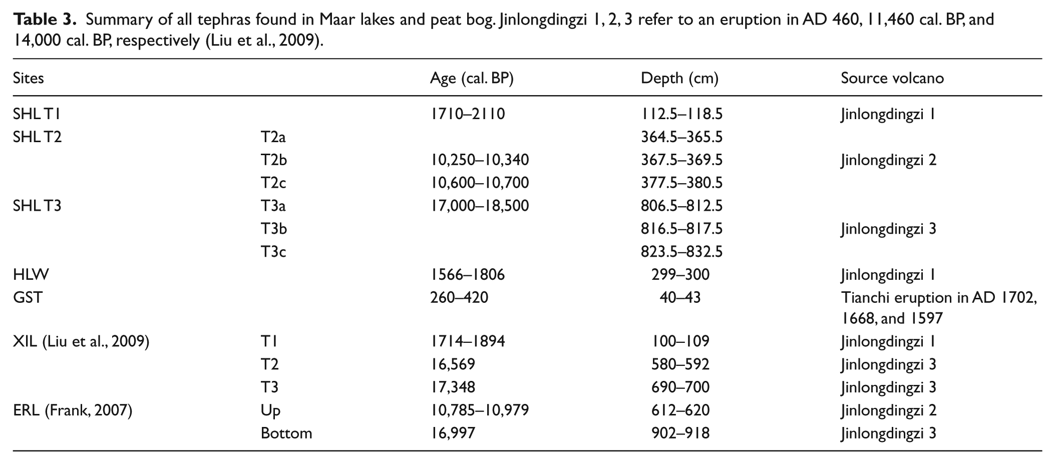
According to AMS 14C dating, the ages for three tephra layers in SHL sediments are as follows – T1: 1710–2110 cal. BP; T2: 10,250–10,700 cal. BP (T2a and T2b are 10,250–10,340 cal. BP, T2c is 10,600–10,700 cal. BP); T3: 17,000–18,500 cal. BP. Liu et al. (2009) through varve-chronology reveals that three basaltic explosive eruptions of Jinlongdingzi occurred at AD 460 (1600 cal. BP), 11,460 cal. BP, and 14,000 cal. BP. The most recent basaltic eruptives (AD 460) can be observed in the outcrops and lake deposits, which combining the dating showed that T1 was produced by the Jinlongdingzi Volcano’s most recent eruption. The age of GST tephra is 260–420 cal. BP, and combined with the geochemical characteristics, this age fits the historic Tianchi eruptions of AD 1702, 1668, and 1597. However, due to the very similar geochemistry of these three eruptions (Liu, 1999), it is hard to say where GST tephra layer came from, and the eruption source needs further investigation.
Tephrostratigraphical studies
Geochemical analyses
CVF
On the basis of its whole rock composition, the 1-ka Tianchi tephra is published as an alkaline rhyolite with a small amount of alkaline feldspar and aegirine augite. The tephra layers, described by Machida et al. (1990), are composed of light and dark colored pumice and glass shards. The analyzed samples were taken from all the fall and flow units at several reference sections. The geochemical compositions of eight representative types from reference samples and published data of Tianchi are shown in Table 2.
Figures 9–11 show the comparison of geochemical characteristics between reference samples and previously published analyses of Tianchi tephra. Analysis of individual shards, except K02014 and K02065, revealed that most rhyolitic tephra which erupted from Tianchi Volcano are compositionally homogeneous (Guo and Wang, 2002; Machida et al., 1990). SiO2 content in most type materials is between 72 and 73 wt%. Analysis also showed CaO (wt%) ranges from 0.1 to 0.3 wt%, K2O ranges from 4.0 to 4.6 wt%, FeO total varies from 3.6 to 4.1 wt%, and Al2O3 ranges from 10 to 11 wt%. K02014 and K02065 are the only samples with abundant brown glass shards. Their composition is as follows – SiO2: 60–67 wt%; FeO: 4.3–4.8 wt%; CaO: 0.8–1.6 wt%; K2O: 5.1–6.2 wt%; Al2O3: 13–18 wt%. It is obvious that K02014 and K02065 have lower SiO2, higher FeO, higher Al2O3, higher K2O, and higher CaO than other type materials. Furthermore, the geochemical analysis of K02014 and K02065 shows a wide diversity in glass shard composition (Figure 9).
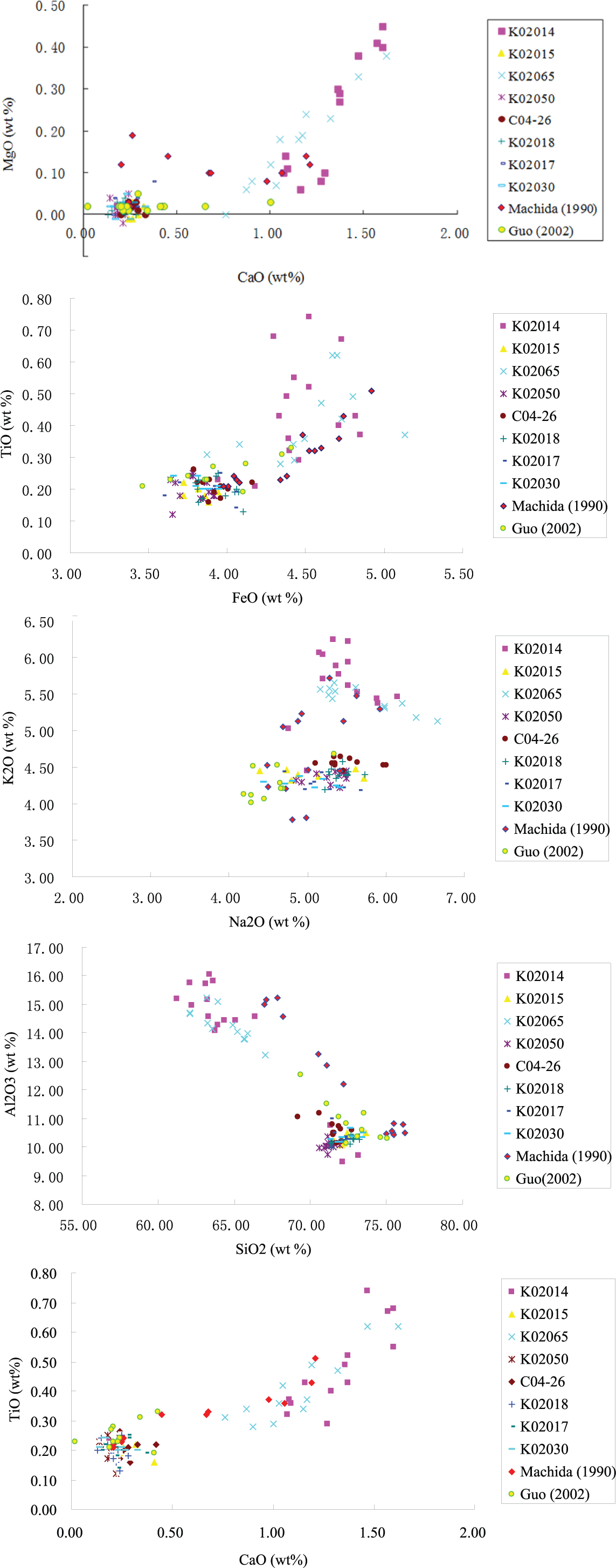
Biplots for comparing glass analyses from proximal reference samples from this study and previously published analyses of glass from Tianchi tephra. Red diamonds are the data published by Machida et al. in 1990 and yellow with green circle dots are data from Guo and Wang (2002). (Data are normalized to 100%.)
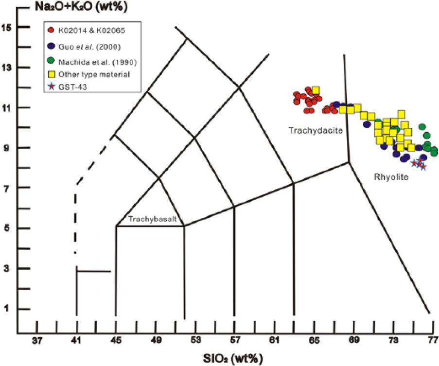
Classification of volcanic ash from Tianchi Volcano reference samples and Gushantun (GST-43) based on the total alkali-silica (TAS after Le Maitre et al. (2002)). (Data are normalized to 100%.)
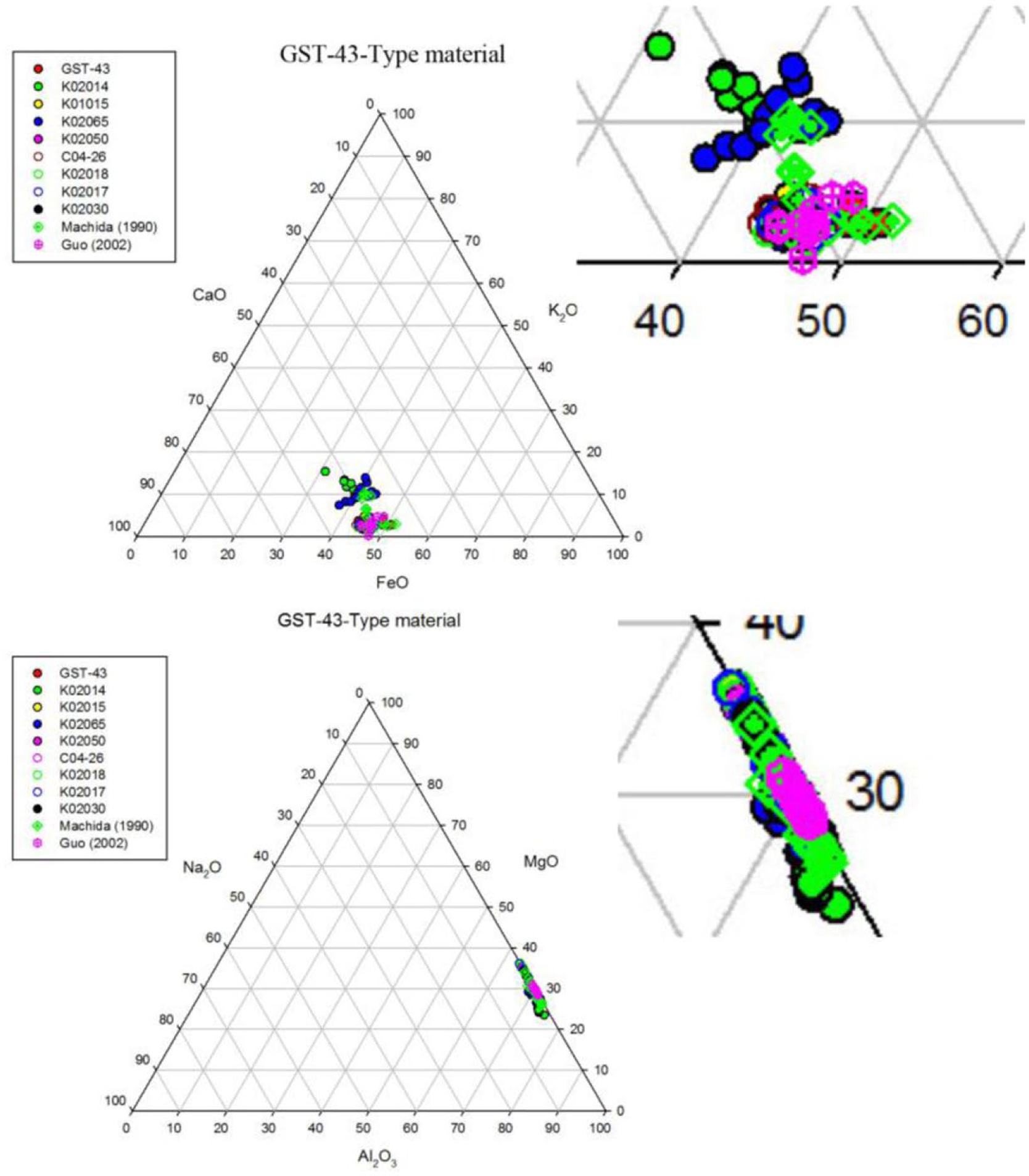
Ternary diagram showing the relative proportion of FeO, CaO, K2O and Al2O3, Na2O, MgO (%) for glass from tephra from Tianchi type material and glass from GST-43. (Data are normalized to 100%.)
LVF
HLW
It has a depth of 443 cm, and one basaltic tephra layer was detected between 299 and 300 cm. The geochemical comparison between the glasses of the tephra layer in deposits at HLW and previously published data for Jinlongdingzi and SHL T1 is shown in Figure 12. It shows the overlap, and they are the most homogeneous populations.
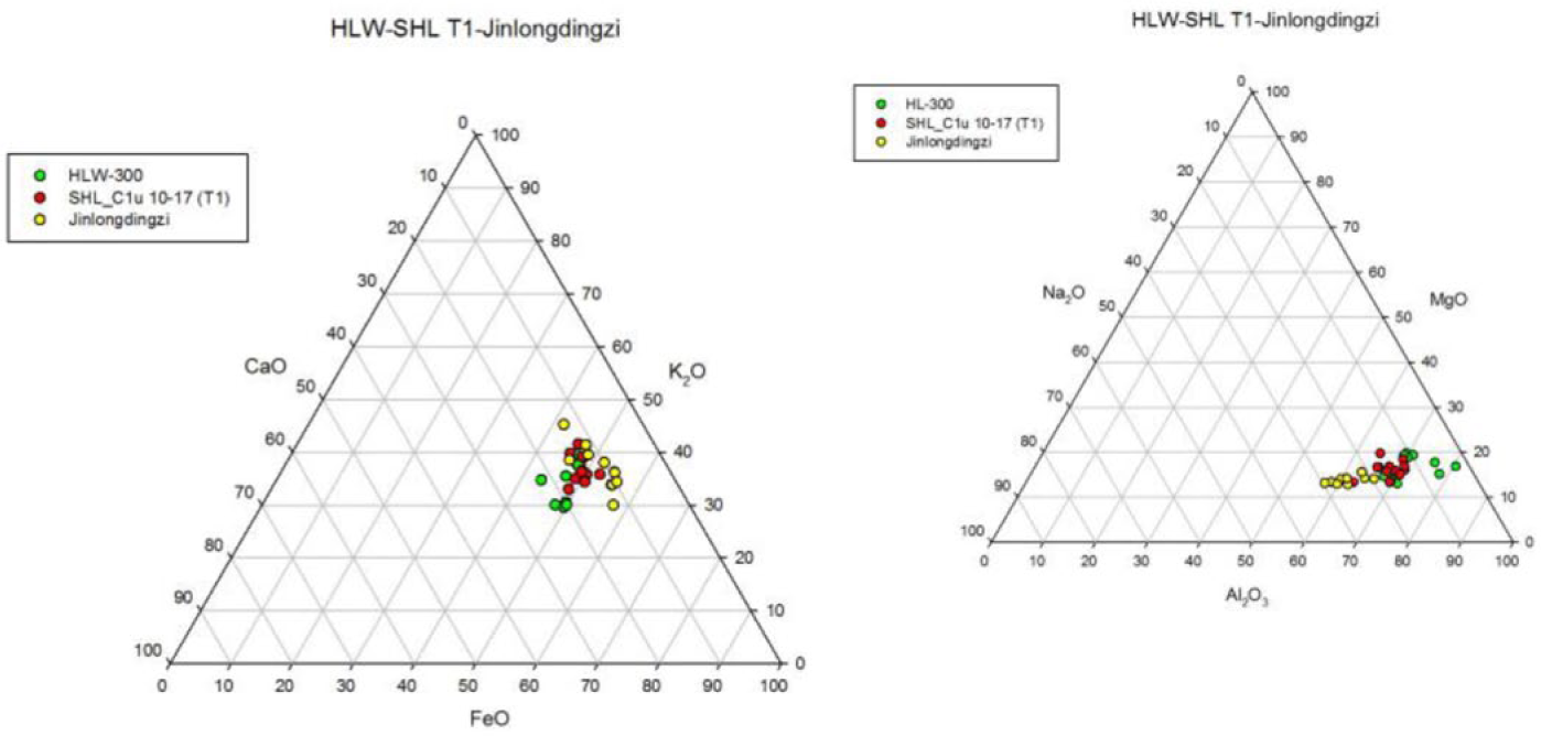
Ternary diagrams showing the relative proportion of FeO, CaO, K2O and Al2O3, Na2O, MgO (%) for glass from tephra layer 1 within Sihailongwan, Jinlongdingzi outcrop and HLW-300. (Diagrams were drawn by the data from Zhao and Hall (2015) and Zhao et al. (2015b), and data are normalized to 100%.)
SHL
It has a depth of 2321 cm, and the sediment of the upper 1000 cm was used for scanning the cryptotephra. There were three visible tephra layers detected (named T1, T2, T3). And three non-visible tephra layers were found within T2 and T3 (named T2a, T2b, T2c and T3a, T3b, T3c). Most tephras from SHL T1 are trachybasaltic and are similar compositionally to those at Jinlongdingzi in the outcrop, although there are still some within the tephrite and basaltic trachyandesite compositional fields. Samples from SHL T2 are trachybasalt. T2a and T2b overlap with those from volcanic ash from Jinlongdingzi. Although T2c is just separate, it is still trachybasalt. Most volcanic ash from three sub-layers of T3 is trachybasalt. Comparison of glass compositions of three tephra layers and cryptotephra sub-layers in the SHL deposit showed that FeO–CaO–K2O are similar for three tephra layers and those at Jinlongdingzi, with a wider compositional spread for shards from T3b (Zhao and Hall, 2015).
GST
It has a depth of 673 cm, and only a few colorless volcanic glass shards were detected in the sediment at 40–43 cm (Zhao and Liu, 2012); their characteristics were compared with those of the colorless shards from the Tianchi type materials. The reason is that GST is located in LVF, and as we know, the rocks distributed in LVF consist of basaltic lavas and basaltic pyroclastic rocks; there is no rhyolite outcropped around it (Guo et al., 2005). Geochemical comparison between the analyses of these colorless shards and those of the Tianchi Volcano type material is shown in Figures 10 and 11. The glass from the volcanic ash detected from GST has similar geochemical characteristics to glass from the Tianchi type material. Furthermore, the TAS plot shows that the glass from the volcanic ash from GST is rhyolite.
Comparisons also have been made between the tephra shards in the GST peat with those from Machida et al. (1990), Guo and Wang (2002), and the published data from Longgang area (Zhao and Hall, 2015). From Figures 10 and 11, we can obviously see that the glass shards detected in sediments at GST show similarity with those from the Tianchi eruption but may differ from those from Jinlongdingzi. The geochemical characteristics of the glass from Jinlongdingzi and Tianchi tephras show marked dissimilarities.
Discussion
SHL T1
Tephra layers are well preserved and corresponded stratigraphically with those in SHL T1, HLW, and XIL (T1) (Liu et al., 2009) (blue broken lines). Radiocarbon ages for the tephra layers in HLW and XIL are 1566–1806 and 1714–1894 cal. BP, respectively. This tephra is not present in ERL (Frank, 2007), possibly because the slump dispersed this thin tephra layer (Frank, 2007). Peat bog GST does not contain this layer, maybe because of the different distribution and preservation of tephra shards for peat bog and lake sediment (Figure 1).
As a possible source volcano and also according to the geochemical analysis and supported with radiocarbon data, SHL T1 came from the Jinlongdingzi Volcano eruption. The age for this eruption is defined by most scientists as 1600 yr BP (AD 460, 1336–1694 cal. BP) (e.g. Cheng et al., 2008; Fan et al., 1999, 2002; Liu et al., 2009). The age is slightly younger when compared with the tephra layer within the SHL and XIL deposits. The age discrepancies may arise from some carbon reservoir effect within the aquatic ecosystems or from older marginal organic material being incorporated into the sediment from the deepest part of the lake or from a combination of these processes (e.g. Davies et al., 2004; Guilderson et al., 2005; Oldfield et al., 1997; Oswald et al., 2005).
Considering the evidence, the first tephra layer found in SHL came from the Jinlongding AD 460 eruption. The glass shards are deposited in HLW and XIL as well, but due to slumping it was not detected in ERL. Furthermore, most glass shard sizes in this layer are large (over 100 µm) with sharp edges and bubbles which showed they are most likely airfall tephra.
SHL T2
Tephras could be found through the whole tephra layer with SHL T2, however not in the same concentration. These sub-layers represent three layers with comparatively numerous tephra shards. Most shards are over 100 µm with bubbles and sharp rims which appear similar to shards in T1. The stratigraphic position (Figure 1) of T2c, T2b, and T2a shows that they represent the base to top, respectively, of a thick continuous tephra layer. If this unit represented an evolving eruption, shards should become more basic toward the top of the sequence, SiO2 should decrease, and FeO should increase toward the top of the tephra unit. However, both Figures 5 and 6 show the same trend of T2a and T2b for most major element analysis and differ slightly from T2c. The FeO content of these three sub-layers differs less. In the stratigraphic figure (Figure 1), there is a 2-cm gap between T2a and T2b, but 8 cm between T2b and T2c.
The published varve-chronology for the Jinlongdingzi Volcano eruption revealed that before the big eruption in AD 460, two more eruptions happened in 11,460 and 14,000 cal. BP (Liu et al., 2009). Varve-chronology can be compromised by missing or adding varves, ambiguous laminations, human counting error, and so on (e.g. Tian et al., 2005), possibly explaining the few hundred years age difference between this layer and Jinlongdingzi. SHL T2 is also well preserved and corresponded stratigraphically with those in ERL (Frank, 2007; Figure 1, Table 3). The radiocarbon age for the first tephra layer in ERL is about 10,785–10,979 cal. BP, which corresponded with T2c in SHL, shown with red broken lines in Figure 1.
Summary of all tephras found in Maar lakes and peat bog. Jinlongdingzi 1, 2, 3 refer to an eruption in AD 460, 11,460 cal. BP, and 14,000 cal. BP, respectively (Liu et al., 2009).
Considering all the evidence described above, the glass shards in SHL T2 are fall events and represent two eruptions of Jinlongdingzi Volcano. T2c represents an earlier eruption than T2a and T2b. It could be argued that after the 11,460 cal. BP eruption, the Jinlongdingzi Volcano remained dormant for about 500 years, followed by a similar basaltic eruption that occurred at about 10,250–10,340 cal. BP.
SHL T3
Tephra distribution in SHL T3 is similarly uneven to T2. T3a and T3b glasses have a wider compositional spread for most major element analyses; however, T3c is quite concentrated. Most tephra shards in the sub-layers overlap with Jinlongdingzi tephra geochemistry and they are all trachybasaltic. The geochemical composition based on FeO, CaO, and K2O are similar for the three sub-layers and Jinlongdingzi, with a wider compositional spread for shards from T3b. In his paper, Liu et al. (2009) stated that tephra layers T2 and T3 in XIL were found and had similar ages, 16,569 and 17,348 cal. BP, respectively. He also described the similar geochemical characteristics of these two layers and Jinlongdinzi Volcano. Through research on ERL, the second tephra layer detected by Frank (2007) also showed geochemistry similar to Jinlongdingzi, the calibrated radiocarbon age being 16,996 cal. BP. These correspond with SHL T3 in this paper. Due to possible sample resolution, neither T2 nor T3 was detected in HLW and GST here.
Considering the evidence, tephras in SHL T3 came from an earlier eruption of Jinlongdingzi Volcano occurring at about 17,000–18,500 cal. BP, and these tephras are most likely fall tephra. Although this eruption has three stages, they all emitted geochemically similar glass shards. It could be argued that T2 and T3 in XIL came from different stages of this eruption event which corresponded with T3 in SHL and the second tephra layer in ERL. The green broken line marks this in Figure 1.
In summary, SHL T1 is 112.5–118.5 cm and the age is 1710–2110 cal. BP, and this tephra layer came from Jinlongdingzi eruption in AD 460; SHL T2 has three sub-layers, named SHL T2a, SHL T2b, and SHL T2c, and the depth and age are 364.5–365.5 cm (10,250–10,340 cal. BP), 367.5–369.5 cm (10,250–10,340 cal. BP), and 377.5–380.5 cm (10,600–10,700 cal. BP), respectively. This tephra layer came from Jinlongdingzi eruption in 11,460 cal. BP. SHL T3 also has three sub-layers which are named SHL T3a (806.5–812.5 cm), SHL T3b (816.5–817.5 cm), and SHL T3c (823.5–832.5 cm). The age for this tephra layer is 17,000–18,500 cal. BP which came from the Jinlongdingzi eruption in 14,000 cal. BP. Tephra layer which was detected in HLW is 299–300 cm and the age is 1566–1806 cal. BP and it came from the Jinlongdingzi eruption in AD 460. The few glass shards which were found in GST peat bog is 40–43 cm and the age is 260–420 cal. BP, and many of these glass shards came from Tianchi eruption in AD 1702, 1668, and 1597. According to the published data from XIL and ERL, glass shards detected in XIL T1 came from Jinlongdingzi eruption in AD 460; XIL T2, XIL T3, and ERL bottom were from Jinlongdingzi eruption in 14,000 cal. BP; ERL came from Jinlongdingzi eruption in 11,460 (Table 2).
Tianchi Volcano and Jinlongdingzi Volcano are both active and erupted several times during the historical period. Glass shards in SHL T1, T2, T3, HLW, and GST may be used as marker horizons beyond the LVF and CVF.
Conclusion
A total of 45 reference samples have very similar geochemical characteristics to Tianchi Volcano eruption and the published data of GST peat bog. In further description, the few glass shards which were found in GST were considered coming from the Tianchi Volcano eruption in AD 1702, 1668, and 1597.
One basaltic tephra layer was found in HLW 299–300 cm, in two clear parts. Geochemistry and radiocarbon age showed that part of them came from Jinlongdingzi AD 460 eruption and the others may be from an earlier eruption. Or, there are two stages for the Jinlongdingzi AD 460 eruption; during that time, higher SiO2 and lower FeO erupted first, followed by the lower SiO2 and higher FeO tephra.
Through the investigation of tephra layers in the sediments of HLW and published data of SHL, GST, XIL, and ERL, tephras are well preserved and corresponded stratigraphically with those in lake SHL T1, lake HLW, and lake XIL T1. Tephra SHL T2 corresponded stratigraphically with the first tephra layer in ERL. Tephra layers T2 and T3 in XIL probably corresponded stratigraphically with SHL T3 and ERL T2.
The tephra that originated from the Tianchi eruption was first found in Hokkaido, Japan, and later in the Sea of Japan, North Korea, nearby coastal area of Russia, marine sediments, Greenland ice cores, and in the sediments of maar lakes in northeastern China. The westward boundary of the eruptives includes the LVF. The impact of the Tianchi Millennium eruption on regional and global environmental records needs further studies.
These tephra (layers) provide accurate temporal marker layers which can be used to verify or corroborate other dating techniques. By linking sequences widely separated by location into a unified chronology, the tephra layers can correlate climatic sequences and events to assess major volcanism in the late Quaternary of the Changbaishan area.
Footnotes
Acknowledgements
Great thanks to Professor John Dodson, from Australian Nuclear Science and Technology Organisation (ANSTO), and Dr Liu Qiang, from the Institute of Geology and Geophysics, CAS, for site selection, sample collection, and also for their thoughtful reviews and comments. Thanks to Professor Paula Reimer and Dr Maarten Blaauw, Queen’s University Belfast UK, for their help in calibrating the radiocarbon dates. Thanks to Zhu Hui and Wang Xiaoli from College of Geography and Tourism, Chongqing Normal University, Chongqing, for their help in drawing Figure 3. We are also grateful to the editors and the anonymous reviewers for their constructive comments and suggestions for this manuscript. I would like to thank Professor Valerie Hall (one of the authors and also my supervisor) for her support and guidance throughout the research. She passed away on 28 July 2016; we will miss her but never forget her.
Funding
This work was supported by the National Natural Science Foundation of China (Grant no. 41202260) and Overseas Research Scholarship (UK, 2007–2010).