



Abstract
The nature and extent of pre-Columbian (pre-AD 1492) human impact in Amazonia is a contentious issue. The Bolivian Amazon has yielded some of the most impressive evidence for large and complex pre-Columbian societies in the Amazon basin, yet there remains relatively little data concerning the land use of these societies over time. Palaeoecology, when integrated with archaeological data, has the potential to fill these gaps in our knowledge. We present a 6000-year record of anthropogenic burning, agriculture and vegetation change, from an oxbow lake located adjacent to a pre-Columbian ring ditch in north-east Bolivia (13°15′44″S, 63°42′37″W). Human occupation around the lake site is inferred from pollen and phytoliths of maize (Zea mays L.) and macroscopic charcoal evidence of anthropogenic burning. First occupation around the lake was radiocarbon dated to ~2500 calibrated years before present (BP). The persistence of maize in the record from ~1850 BP suggests that it was an important crop grown in the ring-ditch region in pre-Columbian times, and abundant macroscopic charcoal suggests that pre-Columbian land management entailed more extensive burning of the landscape than the slash-and-burn agriculture practised around the site today. The site was occupied continuously until near-modern times, although there is evidence for a decline in agricultural intensity or change in land-use strategy, and possible population decline, from ~600–500 BP. The long and continuous occupation, which predates the establishment of rainforest in the region, suggests that pre-Columbian land use may have had a significant influence on ecosystem development at this site over the last ~2000 years.
Keywords
Introduction
In recent decades, there has been a paradigm shift in ideas over the size and complexity of pre-Columbian (pre-AD 1492) Amazonian societies. Rather than being limited to small, semi-nomadic, hunter-gatherer groups and shifting horticulturalists (Meggers, 1992), there is abundant archaeological evidence, in the form of settlement remains, artificial earthworks and Amazonian dark earth (terra preta) soils (Woods et al., 2009), for sedentary groups with relatively large populations, in many different parts of the Amazon basin. Some of the major archaeological sites occur in the Llanos de Moxos (LDM), Bolivia (Erickson, 2000; Lombardo and Prümers, 2010; Lombardo et al., 2010; Saunaluoma, 2010; Walker, 2009), eastern Acre state (Pärssinen et al., 2009; Schaan et al., 2012), the Upper Xingu (Heckenberger, 2003), the central Amazon (Glaser, 2007; Heckenberger and Neves, 2009), Marajó Island (Roosevelt, 1991; Schaan, 2012) and Amapá state (Saldanha and Cabral, 2010), Brazil, and coastal French Guiana (Iriarte et al., 2012). Denevan (2014) has estimated a pre-Contact population of at least 5–6 million in Greater Amazonia (with the caveat that population density was not even across the basin, but concentrated in certain ‘more productive’ environments). It has been suggested that these pre-Columbian populations had a much more extensive impact on Amazonian environments than previously assumed and played an intrinsic part in the development of its ecosystems, through altering the floristic composition, soils, hydrology and topography of the landscape (Clement and Junqueira, 2010; Denevan, 1992; Erickson, 2008; Heckenberger et al., 2007; Levis et al., 2012; Lombardo et al., 2010; Saldanha and Cabral, 2010). However, there is still considerable debate over the type of land use, the scale of environmental impact, and the chronology of these societies.
The LDM, located in the Bolivian department of the Beni (Figure 1) in south-west Amazonia, has some of the most diverse and extensive examples of pre-Columbian earthworks in the Amazon Basin (Denevan, 1966; Walker, 2008). These include raised agricultural fields (Rodrigues et al., 2014; Walker, 2004), monumental habitation mounds (Lombardo and Prümers, 2010), canals, causeways and ring-ditch structures (Erickson, 2000; Prümers, 2014a, 2014b; Prümers and Betancourt, 2014a), which together are indicative of large and socially complex, sedentary populations. The north-east province of Iténez is a unique archaeological sub-region within the Beni. It is characterised by extensive ring-ditch earthworks alongside causeways, ditched agricultural fields, and fish weirs (Denevan, 1966; Erickson, 2000; Lombardo et al., 2013). It is also home to the Iténez Forest Reserve, which was established in recognition of the unique species diversity of this region. However, to date, research in this important historical and natural landscape has been limited. Detailed archaeological investigations have been published from only one site, Bella Vista Village (BVV; Dickau et al., 2012; Prümers, 2009; Prümers et al., 2006), and limited palaeoecological work has been carried out (Carson et al., 2014).
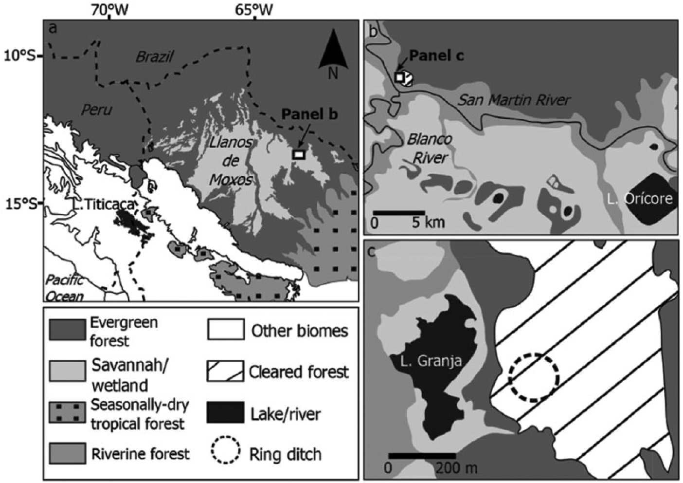
Map of the study region and site locations showing (a) the Llanos de Moxos in Bolivia with study area highlighted, (b) northern Iténez, with the position of Laguna Granja on the Pre-Cambrian Shield and relative to Bella Vista Village, which is represented as a small area of cleared land on the Pre-Cambrian Shield, and (c) vegetation cover around Laguna Granja and position of the Granja del Padre ring ditch (after Carson et al., 2014).
Remote sensing and ground-based surveys are beginning to map the spatial extent of earthworks in Iténez (Erickson, 2010; Prümers, 2012a, 2012b), which have been estimated to cover an area of 12,000 km2 across the whole province (Erickson, 2010). The large number of earthworks below what is now closed-canopy rainforest in this region is suggestive of significant pre-Columbian environmental impact. However, as argued in Carson et al. (2014), one cannot make such inferences based solely upon the spatial extent of earthworks within the modern landscape, but must also know the palaeoenvironmental context of their construction. This is because the spatial extent of forest versus savannah/grassland may have changed through time. Palaeo data can also inform us about important aspects of the nature of land use, for example, whether it involved extensive burning, clearance or suppression of forest growth. Improving our knowledge in this area will inform wider debates over the resilience of Amazonian ecosystems to long-term anthropogenic impacts and the extent to which parts of Amazonia can be considered a pristine versus anthropogenic landscape (Barlow et al., 2012; Heckenberger, 2003; Meggers, 2003; Peres et al., 2010). It has been suggested that pre-Columbian land use had a significant impact on Holocene biomass levels and carbon emissions, through deforestation and burning (Dull et al., 2010; Nevle et al., 2011). Testing the validity of this early Anthropocene hypothesis in Amazonia requires a better understanding of the scale and nature of pre-Columbian impact.
Archaeological excavations in Iténez are also documenting the material culture of the earthwork-building societies, and have provided dating from occupation layers within excavated ring ditches (Prümers, 2014a, 2014b; Prümers and Betancourt, 2014b; Prümers et al., 2006). Archaeobotanical analyses from one of these excavations have uncovered aspects of palaeo diet (Dickau et al., 2012), suggesting that maize may have been an important crop grown in the region. Historical ecological studies (which are informed by modern ethnographic data) of the vegetation surrounding earthwork sites have attempted to reconstruct the legacy of pre-Columbian land management within extant forest in lowland Bolivia (Erickson, 2010; Erickson and Balée, 2006). However, these studies often lack the temporal depth/continuity to be able to discern changes in land use, agriculture and legacy of environmental impact, over Holocene timescales. Palaeoecological data can provide a deeper temporal perspective on pre-Columbian human–environment interactions and, subsequently, their legacy in the modern landscape. Furthermore, by dating activities such as burning, agriculture and clearance, it may be possible to recognise periods of occupation at a site that are not visible in the archaeological record, because of poor preservation. Gaining a sound chronology of occupation is vital for informing debates over the antiquity and decline of indigenous Amazonian societies. There is strong historical and archaeological evidence for a widespread, post-contact, native population collapse driven by epidemic crises across the Americas (Denevan, 1992, 2014; Dobyns, 1963, 1966). However, the decline of human activity at some Bolivian sites appears to predate European Contact (Whitney et al., 2014), and may reflect site abandonment due to internal social, political or environmental/climatic factors.
In order to best exploit the complementary aspects of palaeoecological and archaeological data, Mayle and Iriarte (2014) proposed an integrative approach, combining local-scale palaeoecological records from small lakes with archaeological/archaeobotanical data from nearby archaeological sites. Although such an approach has long been used in other parts of the world (e.g. Europe), it has only recently been adopted in Amazonia (Iriarte et al., 2012; Whitney et al., 2013, 2014). The regular and continuous nature of sediment accumulation in lakes, and our ability to isolate and identify cultigens through pollen and phytoliths, allows for a continuous chronology of human settlement/land use. Pollen and phytoliths have been shown to be complementary proxies when reconstructing tropical environments from lake/bog sediments (Iriarte et al., 2012; Whitney et al., 2013), with pollen providing higher taxonomic resolution for arboreal taxa, and phytoliths for grass and herb taxa (Piperno, 2006). By combining palaeoecological and archaeological data, over comparable spatial scales, we gain insights into the land-use strategies of pre-Columbian peoples, the spatial extent of past impacts, and the palaeoenvironmental context of those human–environment interactions.
Aims
In this paper, we apply an integrative approach to investigate pre-Columbian human–environment interactions at the BVV archaeological site, in north-east Bolivia. This is achieved by analysing pollen, phytoliths, and macroscopic charcoal from Laguna Granja (LG), an oxbow lake located within BVV and adjacent to the Granja del Padre (GDP) ring-ditch feature. The pollen and charcoal records from LG were previously discussed in Carson et al. (2014), in comparison with a regional-scale lake record, to determine the palaeoenvironmental context of pre-Columbian geometric earthwork construction across this region and wider southern Amazonia. Here, these pollen data are combined with new phytolith data from LG, as well as archaeological data from previous excavations (Dickau et al., 2012; Prümers et al., 2006), in order to better define the occupation history of the BVV site and discuss in greater detail the site-specific land-use practices and potential environmental impacts of its pre-Columbian inhabitants. Specifically, we expand upon the findings of Carson et al. (2014) by addressing the following questions:
What was the period of occupation on the site and did abandonment coincide with the arrival of Europeans ~500 BP?
What was the subsistence strategy? What were the staple crops – maize, manioc and/or sweet potato? Did this change over time?
What was the nature of pre-Columbian land management (i.e. did it involve extensive burning, clearance or manipulation of economically useful forest resources) and what was its spatial extent?
What legacy, if any, has pre-Columbian land use left in the modern vegetation?
Study site, physical setting, and archaeological context
Northern Iténez
The modern village of Bella Vista is located in the north of Iténez, the easternmost province of the Beni department, Bolivia. The village lies on the north side of the San Martín River (Figure 1), which marks the geo-ecological divide between two Amazonian landscapes. To the north of the river, the terra firme (non-flooded) Pre-Cambrian Shield (PCS) supports dense-canopy, evergreen rainforest, which forms part of the Madeira-Tapajós rainforest ecoregion that extends from south of the Amazon river down to the Brazilian-Bolivian border (Olson et al., 2010). To the south and west is the LDM, a vast, low lying sedimentary basin which, due to the impermeability of its clay sediments (Clapperton, 1993), becomes largely flooded during the annual wet season from November to March. As a result of this annual flooding, the landscape comprises a wetland savannah, interspersed by small outcrops of the PCS (Clapperton, 1993), which support terra firme rainforest, and are commonly called ‘forest islands’. Extensive ring-ditch earthworks, ranging from discreet circular ditches hundreds of metres in diameter to kilometre-long, curvilinear ditches, are distributed across the terra firme landscape of both the main PCS in the north and the forest islands of the LDM to the south. In the savannah of the LDM, there are also ditched agricultural fields and linear causeway structures which run between the forest islands, and in the far south-east of the province, zigzagged ‘fish weir’ structures (Erickson, 2000; Lombardo et al., 2013).
Archaeology of BVV
Surveys over an area of ~200 km2 around BVV have documented numerous pre-Columbian ditched earthworks, enclosing areas of up to 200 ha (Prümers, 2012a, 2012b). Two of the circular ditches, GDP and BV-3, were excavated by Prümers et al. (2006). The two ring ditches are located 1 km apart and are connected by a long, semi-circular ditch, which surrounds an area of 150 ha. The GDP ring ditch (Figure 2) has a 2-m deep trench and measures 150 m in diameter. A total area of 600 m2 of GDP was excavated, uncovering 16 urn burials and a single thin cultural layer, which was radiocarbon dated from soot on ceramic sherds to between ~650 and 750 BP (all dates calibrated years before present). BV-3 also had a single, shallow occupation layer, which was radiocarbon dated from charcoal on ceramic sherds to ~550–570 BP (Prümers et al., 2006). Excavations were also conducted at a location in the centre of the modern town (BV-1) where ceramics had been uncovered by construction work. Radiocarbon dates from the BV-1 site dated the occupation layer between ~700 and 640 BP. The dates, with 95% confidence interval age ranges, are summarised in Figure 3.
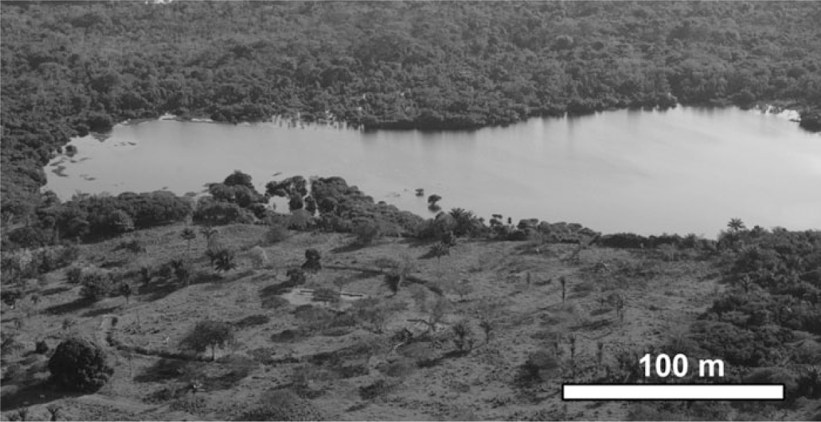
Aerial photograph of Laguna Granja and the adjacent Granja del Padre ring ditch. The cleared area around the ring ditch represents modern forest clearance for cattle ranching. Image taken in summer 2008 by HP.
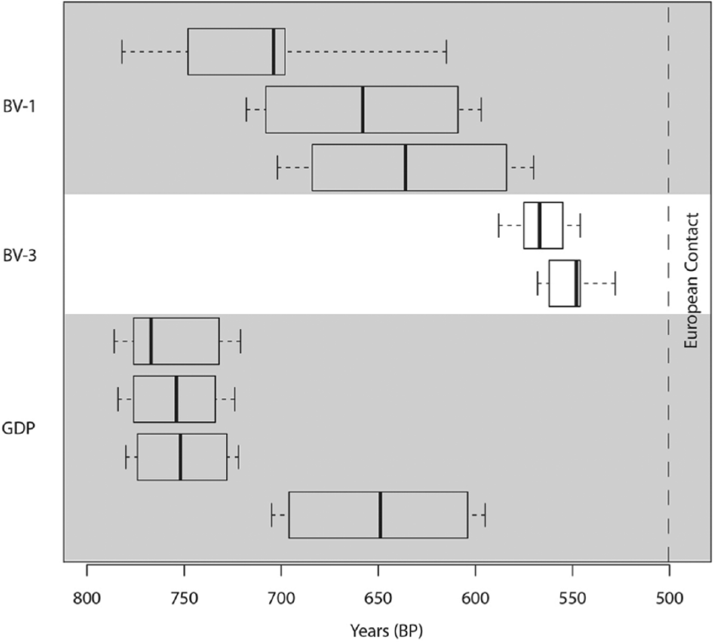
Radiocarbon dates from archaeological contexts at BV-1 (three dates), BV-3 (two dates) and Granja del Padre (four dates) excavations, at Bella Vista Village. Originally reported in Prümers et al. (2006). Black lines indicate the median age; box indicates 68% confidence interval age range; tails represent the 95% confidence interval age range; all calibrated using IntCal13 (Reimer et al., 2013). The approximate date of European contact (~500 yr BP) is shown by a dashed line.
The function of the ring ditches in this region remains unknown. Historical accounts from early European travellers in the Iténez region describe settlements with a defensive ring ditch (Nordenskiöld, 1910), which was enhanced by a palisade (Altamirano, 1891; Block, 1994). The design of the ring ditches around BVV led Prümers et al. (2006) to conclude that they were probably defensive features. However, the excavations at BVV and around Baures in the south (Prümers and Betancourt, 2014b) found no evidence of wooden remains or post holes that would indicate the construction of a palisade. Some ring ditches, such as GDP, also functioned as burial sites (Prümers et al., 2006).
The subsistence strategy of ring-ditch builders and other pre-Columbian groups in lowland Bolivia involved agriculture (Dickau et al., 2012; Whitney et al., 2013, 2014). It has been hypothesised that Amazonian farmers became increasingly dependent upon intensive food-production systems through the late Holocene, due to increasing population density (De Paula Moraes and Neves, 2012; Rebellato et al., 2009), but there is a long-standing debate over whether the predominant staple crop that supported these increasingly complex societies was manioc (Manihot esculenta Crantz; Arroyo-Kalin, 2010; Heckenberger, 1998; Lathrap, 1970; Oliver, 2001; Piperno and Pearsall, 1998a) or instead maize (Zea mays L.; Roosevelt, 1993). Manioc is the staple crop grown in the Iténez region today. However, in an analysis of the phytoliths and starch grain residues left on stone tools excavated from the BVV site, Dickau et al. (2012) found maize to be the main identifiable cultigen. Starch grains from manioc were also recorded on two handstone tools, but maize starch grains were by far the most common type found. This led the authors to tentatively conclude that maize was an important crop grown on site. A more confident conclusion was not possible because of the small sample size available. Furthermore, independent proxy analysis is needed from the site to test these conclusions.
L. Granja
In order to investigate elements of land use on the BVV site, a local-scale palaeoecological record was required, which could be integrated with the existing archaeological data. The pollen catchment area of a lake is proportional to the lake surface area (Sugita, 1994). Therefore, we selected a small lake for coring, which would represent vegetation on a local scale around the archaeological site. The lake cored for this study, LG (13°15′44″S, 63°42′37″W), is a small (0.2 km2) oxbow lake, located 100 m from the GDP ring ditch (Figures 1 and 2) and 1 km north of the modern BVV. The water depth of the lake is 2 m at its deepest point (measured during the dry season, July 2011). The majority of the lake margins are dominated by riparian forest which, according to local inhabitants, becomes flooded up to a height of 2 m every year during the annual wet season. In exceptional flood years, the lake becomes temporarily reconnected to the San Martín River. On the east side of the lake, a small area of land (~0.3 km2) has been cleared for cattle grazing.
Materials and methods
Sample acquisition
Fieldwork was carried out in June–July 2011. Samples were taken from a stable floating platform in the central, deepest part of the lake, using a modified drop-hammer Livingston piston corer (Colinvaux et al., 1999). Surface sediments were taken using a 5-cm diameter Perspex® tube and piston to capture the uppermost unconsolidated sediments. Softer sediments from the surface core were sub-sampled in the field at 0.5-cm intervals and stored in watertight plastic tubes. Firmer sediments were extruded in the field as intact cores and shipped back to the UK in robust, watertight packaging. Livingstone core sections were transported in their aluminium core tubes and extruded in the lab in the UK. In the lab, the sediment cores were split lengthways into equal core halves, one of which was used for destructive sampling while the other was retained as an archive core. All samples were kept in cold storage at 4°C.
Chronology
An age–depth model for the sediment core was derived from five AMS 14C dates obtained from organic lake sediments. All the dates were from non-calcareous bulk sediments, because the core lacked plant macrofossils and macroscopic charcoal particles large enough for radiocarbon dating. Dates were calibrated to 95% (2σ) confidence intervals using the IntCal13 calibration curve in the OxCal program version 4.1 (Reimer et al., 2013; Table 1). Given the small total number of dates, the best representation in an age model was achieved using simple linear interpolations between data points (Bennett, 1994; Telford et al., 2004a; Figure 4). Single age estimates for each date were calculated using the weighted means of the probability distribution of the calibrated ages (Telford et al., 2004b), as this was the best method for representing those calibrated age ranges which have multimodal distributions.
Radiocarbon dates from Laguna Granja.
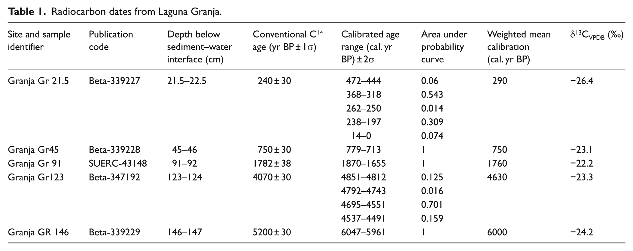
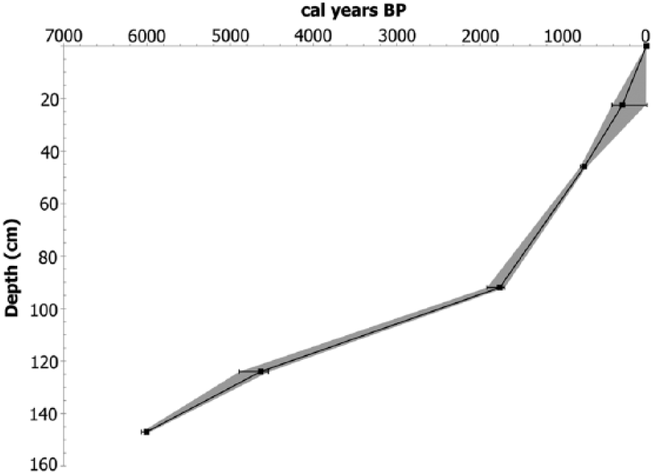
Age–depth model for Laguna Granja from 2σ calibrated radiocarbon dates. Interpolated 95% error range between dates is shown by grey shading.
Modern vegetation survey
During fieldwork, a rapid assessment botanical survey of the vegetation around LG was made by JDS to aid pollen and phytolith identification, and estimation of the spatial representation of the microfossil record. All species encountered along four, 100 m × 5 m transects (orientated north, south, east and west around the lake) were identified and voucher specimens collected for the herbarium of the ‘Noel Kempff Mercado’ Natural History Museum, in Santa Cruz, Bolivia (Table 2).
Results of modern vegetation survey around Laguna Granja.

Indicates that the family or genus was identified in the surface pollen assemblage.
Indicates that the family or genus was identified in the surface-sediment phytolith assemblage.
Pollen analysis
The core was sampled initially at coarse resolution (20-cm intervals) to create a framework pollen profile, after which sample resolution was increased, focusing on depths where significant pollen assemblage changes occurred. From 0- to 110-cm depth, sampling resolution was increased to 5-cm intervals, and from 110 cm to the base at 150 cm, resolution was increased to 10-cm intervals.
A 1-cm3 sub-sample of sediment was prepped from each horizon using a modified sieving protocol designed for optimal recovery of large cultigen pollen (Whitney et al., 2012). All other stages followed the standard pollen preparation protocol (Faegri and Iversen, 1989). Samples were spiked with a known concentration of Lycopodium marker spores for calculation of pollen concentration values, and to confirm that observed changes in pollen percentage abundance were not the result of changes within a closed sum. The pollen in the fine fractions (material < 53 µm) was counted to the standard 300 grains. The coarse fractions (>53 µm) were scanned for large cultigen pollen grains up to a standardised equivalent count of 2000 Lycopodium spores, representing ~0.4 cm3 of the original 1 cm3 of sediment processed. Fossil pollen was identified with reference to the collection of over 1500 tropical pollen specimens (housed at the University of Reading), and from atlases of Neotropical pollen (Bush and Weng, 2007; Colinvaux et al., 1999). Maize grains were distinguished from other wild grasses according to the morphological criteria described in Holst et al. (2007). Where possible, members of the Moraceae family were identified to genus using morphological descriptions from Burn and Mayle (2008). Where genus level identification was not possible, grains were assigned to the Moraceae/Urticaceae undifferentiated category. Cyperaceae and Alternanthera were identified in the modern botanical survey as common aquatic/semi-aquatic types within the modern lake. They were therefore counted, but excluded from the terrestrial pollen sum of 300 grains, and presented as part of the aquatic flora.
Interpretations of the fossil pollen assemblages are also based upon extensive modern pollen rain studies conducted across different lowland Amazonian ecosystem types in north-eastern Bolivia (Burn et al., 2010; Gosling et al., 2005, 2009; Jones et al., 2011).
Phytolith analysis
Sediments were sub-sampled for phytolith analysis at 10-cm resolution throughout the core, with an additional three samples at 22-, 35- and 45-cm depth. Phytolith extraction followed standard procedures established by Piperno (2006). Samples were pre-treated to remove clays through deflocculation and gravity sedimentation using a centrifuge, carbonates were removed using 36% HCl, and organics were removed by heating the sample in a solution of 70% HNO3. Phytoliths were extracted by heavy liquid flotation in ZnBr2 (specific gravity: 2.3 g/cm3) and mounted with Entellan® mounting agent to allow for rotation under the microscope for 3D viewing. Due to the small volumes of sediment available (because of our multiproxy analyses), phytoliths were not separated into size fractions (Piperno, 2006). However, despite these small sediment volumes (minimum 3 cm3), all samples yielded abundant quantities of phytoliths. A minimum of 200 phytoliths was counted per slide, and the whole slide was scanned for diagnostic crop phytoliths. Phytoliths were identified by comparison with a phytolith reference collection of over 750 Neotropical plant taxa held at the University of Exeter (Watling and Iriarte, 2013). Identification of Poaceae short-cell phytoliths followed a system first proposed by Twiss et al. (1969) and later expanded to include other aspects of 3D morphology (Brown, 1984; Pearsall, 2000; Piperno and Pearsall, 1998b). As with the pollen data, Cyperaceae phytoliths are presented separately from the terrestrial sum.
Our interpretations of the fossil phytolith assemblages were also informed by soil-surface phytolith studies, conducted in permanent botanical plots from different lowland Amazonian ecosystems in Noel Kempff Mercado National Park, north-east Bolivia (Dickau et al., 2013).
Charcoal analysis
Macroscopic charcoal analysis was carried out on the core from 0 to 150 cm. Samples were initially analysed at 10-cm intervals. Where this process identified significant vegetation changes and/or burning, the sampling resolution for charcoal analysis was increased. From 0 to 110 cm, sampling resolution was increased to 0.5-cm intervals, while at the base of the core, between 110 and 150 cm, sampling resolution was increased to 5-cm intervals. Sub-samples of 1 cm3 were taken from each horizon and heated in 5% sodium pyrophosphate to disaggregate clay sediments. The samples were then sieved at 250 and 125 µm, and charcoal particles counted in water under 40× magnification. All stratigraphic figures were drawn using the program C2 (Juggins, 2007).
Results and interpretation
Core stratigraphy and chronology
Sediments from LG were cored to a depth of 240 cm, and compiled into a single composite core by cross-correlation of overlapping Livingstone core sequences and a 58-cm surface core. The overlapping cores were correlated using high-resolution charcoal curves. The sediment throughout was a light to medium brown clay, with some fine sands. Pollen preservation between 150 and 170 cm was poor, and therefore, palaeoecological analysis and radiocarbon dating of sediments were focused above 150-cm depth.
A total of five AMS 14C dates were obtained to build a chronology for the LG record (Table 1). No reversals were observed in the chronology (Figure 4).
Modern vegetation and surface-sediment microfossils
The results of the modern vegetation survey are presented in Table 2. The vegetation survey yielded 62 species, mostly representing the inundated/riparian forest zone around the lake. The most common terrestrial tree types were Vochysia mapirensis (Vochysiaceae) and Buchenavia oxcycarpa (Combretaceae). The dominant aquatic species were the fern Marsilea polycarpa (Marsileaceae) and the water hyacinth Eichhornia azurea (Pontederiaceae).
The surface-sediment pollen assemblage from LG has roughly equal proportions of arboreal (48%) and herb (43%) types. The most abundant arboreal taxa are Cecropia (13%), Brosimum (8%), Moraceae/Urticaceae (8%), Alchornea (4%), Arecaceae (palms; 4%), Trema (4%) and Ampelocera (2%). Poaceae (grasses) accounts for 35% of the surface pollen assemblage, while other common herb types include the weedy taxa Asteraceae (4%) and Borreria sp. (4%). Aquatic grasses were not found to be abundant around the modern lake shore, and therefore, it is assumed that the majority of grass pollen and phytoliths in the lake record derive from a terrestrial source. Of the aquatic types documented in the botanical survey, Eichhornia (<1%) is under-represented in the surface pollen assemblage relative to its abundance on the land/water surface, while Cyperaceae (23%) is over-represented.
The surface pollen assemblage contrasts markedly with the phytolith assemblage, which is dominated by herb taxa (75%) over arboreal types (26%). Grasses (62%) are the most abundant herb, comprising mostly Panicoideae types (bilobates (29%), crosses (22%)), followed by rondels (10%), which are a general Poaceae indicator with a cosmopolitan distribution (Pearsall, 2000), and a very small proportion of Chloridoideae, represented by saddle-shaped phytoliths (1%). Heliconia sp. (5%) and bamboos (4%) are present in low abundance. Arboreal types (26%) are represented primarily by globular granulates (20%) and palms (6%). The main aquatic phytolith taxon is Cyperaceae (3%).
Given that trees and grasses produce both abundant pollen and phytoliths (Aleman et al., 2014; Piperno, 2006), it is unlikely that this discrepancy is due to differences in microfossil production. A more likely explanation is that differences in the transport of these two microfossils mean that they represent the landscape around the basin at different spatial scales. Phytoliths, which are silica bodies derived from plant materials, are commonly released by in-situ decomposition of plant organic matter (Piperno, 1988, 2006). Although long distance transport of phytoliths is possible via rivers or advection from large fires, in lakes where fluvial input is low and/or there is a buffer created by surrounding forest vegetation on the shoreline, extra-local and regional phytolith deposition may be limited (Piperno, 2001, 2006). Phytoliths in lacustrine sediment records may therefore represent predominantly local vegetation, as demonstrated at other lake sites in the Bolivian Amazon (Whitney et al., 2013). In contrast, pollen has potential for longer distance transport, especially from anemophilous species such as members of the Moraceae family (Bush, 1995; Bush and Rivera, 1998; Gosling et al., 2005). We therefore infer that the pollen record at LG represents extra-local vegetation around the lake, while the phytoliths represent a more localised catchment area, including the shoreline vegetation.
We can test these ideas by comparing the surface pollen and phytolith assemblages with the modern plant inventory (Table 2). Species which occur in both the plant inventory and the surface pollen assemblage include members of the genera Cecropia, Alchornea, Pourouma and Uncaria. In pollen trap and lake-core studies from other terra firme sites in eastern lowland Bolivia, Cecropia and Alchornea were shown to be common members of humid evergreen riparian forest (Burn et al., 2010). Brosimum is found in the surface pollen assemblage from LG, but was not identified in the plant inventory. We therefore infer that it and other anemophilous, terra firme taxa found in the pollen record, such as Pseudolmedia (Burn et al., 2010), represent an extra-local signal, which derives from the terra firme evergreen rainforest, outside the riparian zone around the lake. The modern vegetation around LG includes a cleared area of farm land (~0.3 km2) on its eastern shore. This and other cleared patches visible immediately around the lake are likely the source of abundant grass phytoliths found in the lake surface sediment, but also contribute to the grass pollen signal.
LG-1 6000–2500 BP
From 0 to 150 cm in the sediment core, pollen and phytolith preservation were good. Pollen and charcoal results are presented in Figure 5 and phytolith results in Figure 6. In zone LG-1 (comprising 11 pollen and five phytolith samples), the pollen assemblages are dominated by Poaceae (40–77% abundance), indicating that the wider terra firme landscape around the lake was covered by savannah during this period. Pollen assemblages with Poaceae proportions of >40% typically represent savannah (Gosling et al., 2009; Jones et al., 2011). The very high proportion of Poaceae pollen (⩾50%), compared with arboreal types (18–38%) in this zone, suggests that the terra firme environment from 6000 to 2500 yr BP was an open savannah with low tree density, rather than a more densely forested woodland savannah or seasonally dry tropical forest (Gosling et al., 2009; Jones et al., 2011). Of the arboreal taxa present, common types are Cecropia sp. (5–17%), Moraceae/Urticaceae (3–10%), Alchornea (0–6%) and Pseudolmedia sp. (0–3%). The taxon Asteraceae (2–10%), which can occur as herbs, shrubs or lianas, is present throughout the zone.
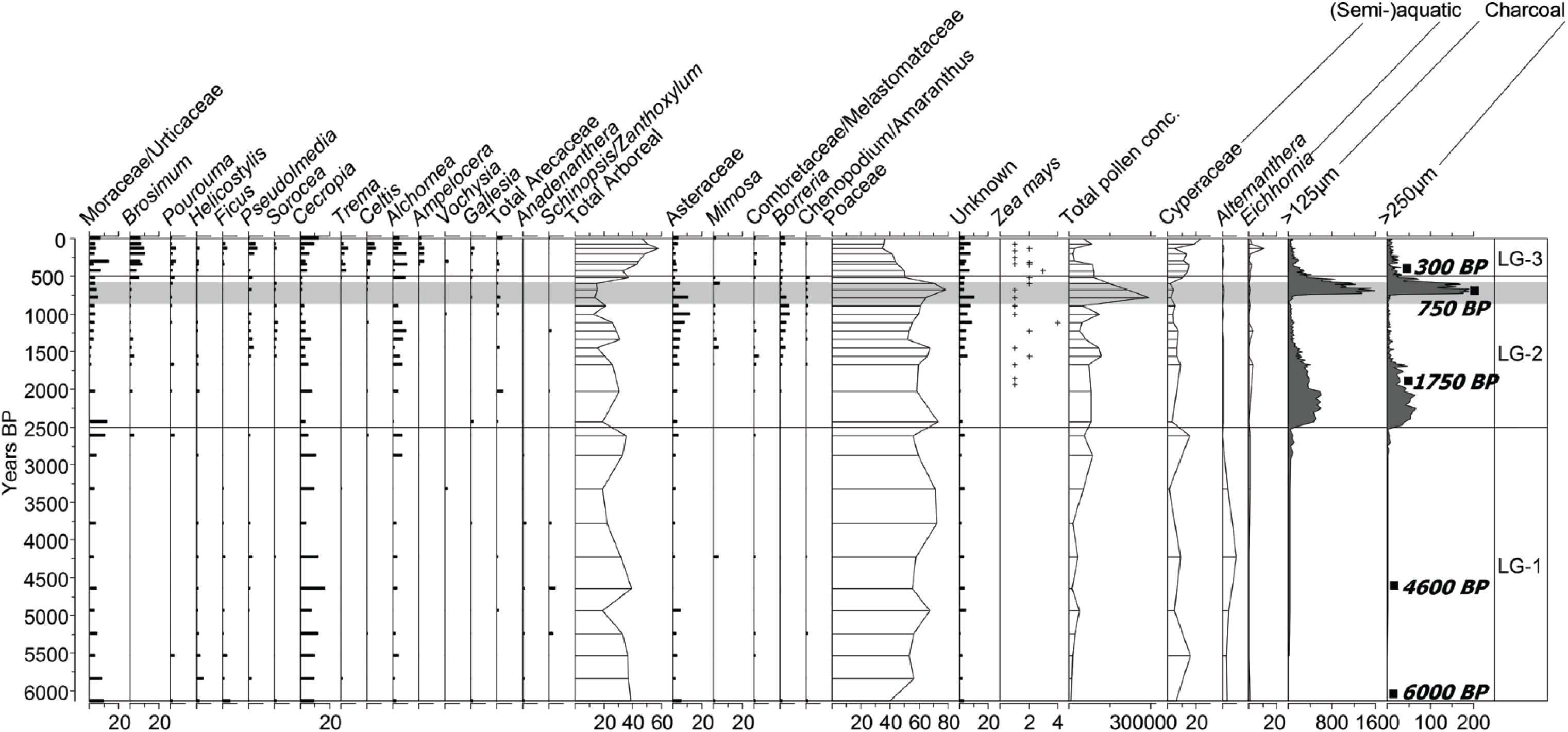
Pollen and charcoal from Laguna Granja plotted against calibrated years before present. Pollen of all taxa with >2% abundance are shown. Pollen is presented as percentage abundance of the terrestrial count of 300 grains, with the exception of Zea mays, which is presented as number of grains. Charcoal is presented as particles per cm3. Calibrated radiocarbon ages from LG are displayed on the right (see Table 1 and Figure 4). The range of radiocarbon dates from archaeological contexts at Bella Vista Village is represented by grey shading (see Figure 3).
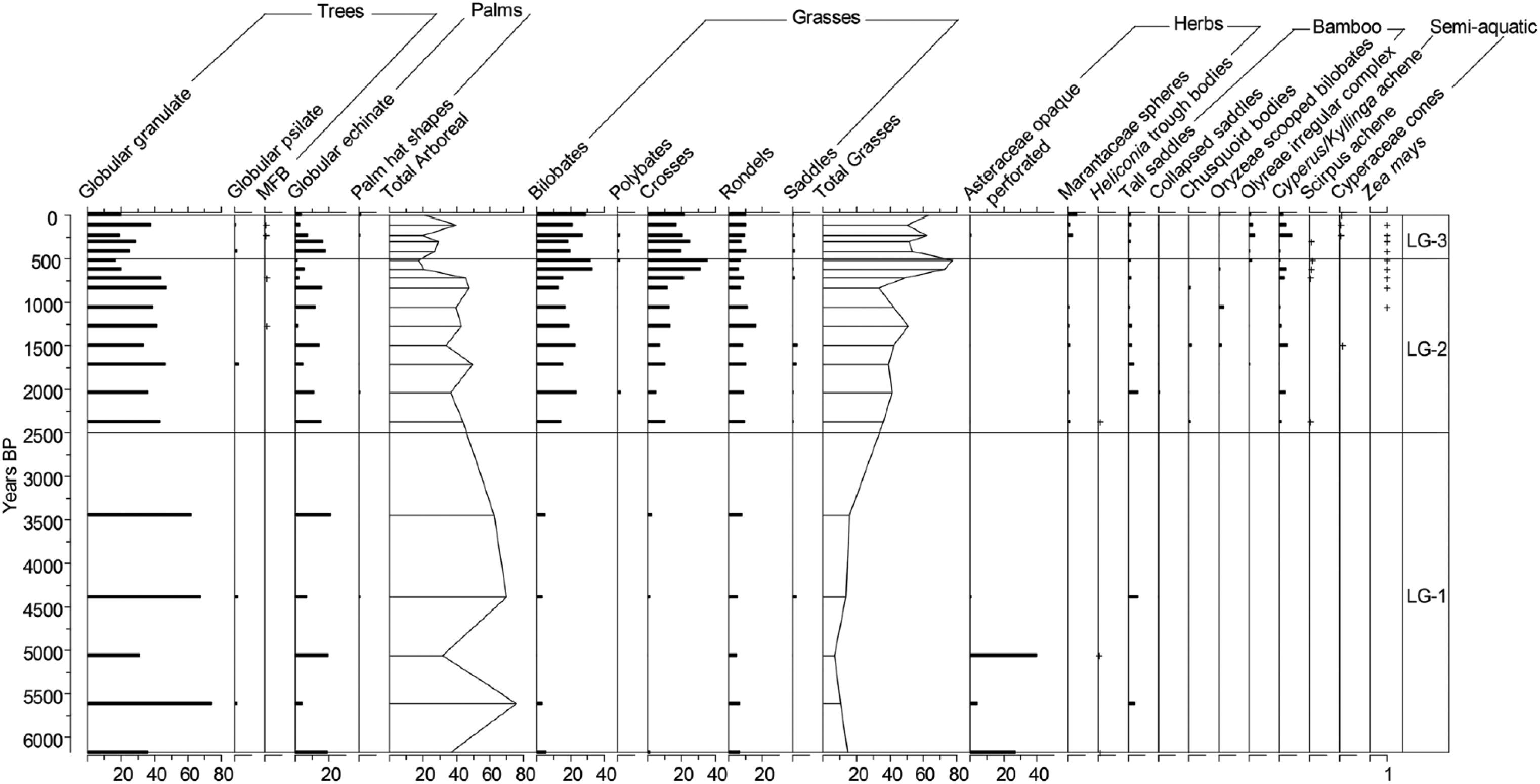
Phytoliths from Laguna Granja plotted against calibrated years before present and expressed as percentage abundance of 200 phytolith count. Zea mayis is presented as a number of phytoliths. The diagram is divided into the same pollen zones used in Figure 5.
The phytolith record in this zone is dominated by arboreal globular granulate type phytoliths (32–75%), with low Poaceae levels (7–16%), low level of palms (4–21%) and abundant Asteraceae (5–41%), suggesting seasonally inundated semi-deciduous dry forest (Dickau et al., 2013). The small contribution of Poaceae phytoliths indicates that the high Poaceae pollen levels in this zone derive from the terra firme landscape, beyond the lake margins. In the pollen record, the presence of Anadenanthera (⩽2%), a tree which is common in seasonally dry tropical forest, but may also grow in seasonally flooded forest (Pennington et al., 2006), may support this interpretation of seasonally flooded forest around the lake margins.
The appearance and high abundance in the pollen record of the semi-aquatic genus Alternanthera sp. (1–8%) in this zone (presented outside the terrestrial sum) is also indicative of swampy conditions around the lake, possibly related to a low stand in the lake’s history, which exposed more of the shoreline for colonisation by Alternanthera. Charcoal levels throughout this zone are low. This is likely due to the presence of semi-inundated riparian forest around the lake at this time, which (1) unlike the savannah in the wider landscape, would not have been susceptible to frequent burning and (2) may have acted as a barrier to the deposition of charcoal from extra-local/regional sources (Aleman et al., 2013).
LG-2 2500–500 BP
In zone LG-2 (14 pollen and 10 phytolith samples), there is a sharp increase in charcoal abundance at ~2500 BP, likely indicating an increase in both the frequency and extent of burning around the lake. This increase in charcoal at LG contrasts with the pattern of decreasing burning seen at this time in the regional-scale records from Lagunas Orícore (LO; Carson et al., 2014), Bella Vista (LBV) and Chaplin (LCH; Burbridge et al., 2004; Mayle et al., 2000). The regional-scale decrease in burning observed across S-W Amazonia has been linked to increasing late-Holocene precipitation, and reduced natural fire potential. This suggests that burning around LG was localised and anthropogenic in origin.
The first maize pollen of the record is found at ~1850 BP, and maize pollen was recovered throughout the rest of the zone. The high Poaceae levels (50–77%) and low total arboreal pollen (15–30%) indicate that the PCS landscape around LG continued to be open savannah throughout this period. However, there is evidence for a shift in floristic composition towards more evergreen rainforest species such as Brosimum (1–6%) and Pseudolmedia (1–4%; Burn et al., 2010; Gosling et al., 2009) in response to increased precipitation. Between ~1600 and 700 BP, charcoal levels decline and in the pollen record there is a moderate reduction in Poaceae (50%) in favour of the weedy taxa Asteraceae (2–10%), Chenopodiaceae/Amaranthus (1–6%) and Borreria (0–2%).
At ~700 BP, there is another sudden spike in charcoal, indicating a second intensive burning period between ~700 and 500 BP, with peak Poaceae levels (78%) occurring at ~680 BP. The disappearance of Alchornea and Celtis and reduction of Cecropia (1–3%) from ~750 to 600 BP suggest opening of the gallery forest. The charcoal peak begins to decline at ~600 BP.
The phytolith record in zone LG-2 shows an expansion of grasses (35–75%) and decrease in woody dicots (18–64%), signalling the opening of the landscape around the lake margins. Bamboos (1–8%) appear in the phytolith record in this zone, and may reflect a floristic transformation towards evergreen forest (Dickau et al., 2013), but may also be the result of human disturbance. Bamboos are a common component of disturbed forest and form constituent flora of evergreen terra firme rainforest (Dickau et al., 2013). This zone also sees the first appearance of maize phytoliths alongside maize pollen in the record at ~1000 BP and throughout the rest of zone LG-2.
LG-3 500 BP–present
Charcoal declines to near-modern levels at the zonal boundary (500 BP) between LG-2 and LG-3 (seven pollen and five phytolith samples). The fall in charcoal concentrations is complemented by a decrease in Poaceae pollen (34–44%) and increase in arboreal pollen types (35–58%), most notably terra firme taxa such as Brosimum (7–10%) and Pseudolmedia (0–6%). These changes signal reduced frequency/intensity of burning and an expansion of evergreen forest into the terra firme areas of the site (Burn et al., 2010). Both the pollen and phytolith records also appear to show expansion of the gallery forest, with woody phytoliths (25–45%) increasing, and the reappearance of Cecropia (3–12%), Celtis (1–6%) and Alchornea (2–9%) in the pollen record. However, grasses remain the dominant component of the phytolith assemblage (48–62%), suggesting that there is still open ground around the lake margins. Maize is found in the pollen and phytolith records until close to modern times (~50–100 BP).
Discussion
Timing of occupation at LG
Archaeological excavations of the two ring ditches, GDP and BV-3, identified a single, thin occupation zone. At GDP, this layer was dated to between ~750 and 650 BP and at BV-3 to between 570 and 550 BP (Prümers et al., 2006). The construction/occupation of the ring ditches is broadly contemporaneous with a period of intense burning and degradation of the riparian forest seen in the LG record, suggesting that this activity was linked with use of the earthworks. Our palaeoecological analyses, however, have revealed a much earlier start to human occupation around LG, with anthropogenic burning evident from ~2500 BP. This is perhaps not surprising given that, so far, excavations and radiocarbon dating at BVV have been limited to the ring-ditch sites. Excavations close to ring-ditch earthworks around Baures in the south of Iténez province (Prümers and Betancourt, 2014a), and in Riberalta, in northern Bolivia (Saunaluoma, 2010), have produced evidence of early, possibly pre-ring ditch occupations, dated to ~1650–1450 BP and ~2100 BP, respectively. Our dating of first occupation of the BVV site from the palaeoecological record is therefore consistent with the wider chronology of occupation in the south-west Amazon. It is unclear whether this early activity around LG represents a culture that was superseded by ring-ditch builders, or whether some of the numerous, undated earthworks on the BVV site were constructed during this early period. Answering this question will require further excavations and dating from terrestrial contexts.
The palaeoecological record from LG also shows that the dating of this cultural layer in the GDP and BV-3 earthworks does not mark the end of occupation on the site. There is a probable decline in population and activity between ~600 and 500 BP, when burning declines and afforestation begins. However, maize agriculture was evidently still practised on the site after this date. This could have been the result of cultivation by a relatively small population later in the site’s history, unlike the once extensive populations that likely built the ring-ditch structures. Maize microfossils are found almost continuously through the upper part of the lake record and until near to modern day (~50–100 BP), suggesting that part of this maize signal derives from cultivation by colonial/20th century populations. There is an interval between ~200 and 250 BP in which no maize pollen or phytoliths were identified. This may represent a transitional period between the final abandonment of the site by native population and its settling by a modern population, although this is speculative, given the limitations in temporal resolution of our record.
The timing of this settlement decline or change in land-use strategy (~600–500 BP), as recorded in the LG record, is intriguing, as it approximately coincides with the arrival of Europeans in the Americas in AD 1492. Historical records reveal that the Spanish did not begin to formally colonise the Iténez region until the 18th century (Alcina Franch and Sáinz Ollero, 1989; Altamirano, 1891; Barnadas, 1985; Block, 1994), and that some Bolivian ring-ditch sites were still inhabited in this late period (Eder, 1985). However, the hypothesis of post-Contact Native American demographic collapse proposes that Old World diseases could have been spread rapidly via extensive native trade routes (Denevan, 1976, 1992; Dobyns, 1963), without the need for direct contact with Europeans. Site abandonment/decline at other southern Amazonian sites, such as the ring-ditch villages in the Upper Xingu, occurred in the century after European arrival, and is ascribed to disease-driven demographic collapse (Heckenberger, 2003).
At first glance, the timing of site decline at LG would appear to support a population collapse linked with European contact. However, closer inspection of the record reveals that burning began to decline from ~600 BP and was lagged by forest expansion, which was complete by ~500 BP. This suggests that site decline around LG began before first European contact. We must treat the dating of this record cautiously, as the age model in this upper section of the core has a wide error range (see Figure 4). When we take into account the interpolated 95% error range of the dates, this places the forest expansion around LG somewhere between 400 and 620 BP, meaning that afforestation of the site could have occurred up to a century before or after European contact. However, given that the dating of this horizon is bounded by two radiocarbon dates, the narrow confidence interval on the lower constraining date Gr45 (95% age range of 680–760 BP), and the linear sedimentation rate throughout the top 100 cm of the core, as indicated by our age model (Figure 4), it would seem reasonable to accept the interpolated age of forest expansion at ~500 BP. We also note that the dating of the charcoal decline at LG, when the interpolated 95% confidence range is taken into account, is between 550 and 690 BP. This still places the beginning of the burning decline before AD 1492.
Other recently published records of pre-Columbian occupation at earthwork sites contemporary with that of LG, located in the central LDM (Whitney et al., 2013, 2014), have dated site decline/land-use change to shortly before the arrival of Europeans. Decline at these sites was evidently caused by factors other than Old World disease. It is also worth noting that the youngest radiocarbon dates obtained so far from ring-ditch (geoglyph) earthworks in Acre State, Brazil, are ~700 BP (Schaan et al., 2012), and the majority of the younger dates obtained from ring-ditch sites in Riberalta are also pre-AD 1492 (Saunaluoma, 2010). Our palaeoecological record, coupled with the dating of archaeological layers at BVV by Prümers et al. (2006), all of which are older than 500 BP (see Figure 3), suggest that a pre-European decline on this site is more likely.
Although a definitive causal link between European contact in AD 1492 and the decline in anthropogenic activity observed at LG is not supported from our data, exchanges between Europeans and native Amazonians nevertheless likely contributed to changes in land-use strategy on sites like BVV in the centuries following contact through, for example, the introduction of metal tools (Denevan, 2001). These new tools made slash-and-burn agriculture a possibility, by reducing the labour and time required to fell a tree, and as such may have fundamentally changed the way native Amazonians impacted the forest landscape.
Agricultural and land-use strategy
In our pollen analyses, coarse fractions were scanned for common cultigen types, including squash (Cucurbita sp.), sweet potato (Ipomoea batatas L.), manioc (Manihot esculenta Crantz) and maize (Zea mays L.), all of which have large pollen grains and can be isolated by sieving (Whitney et al., 2012) as demonstrated in Rushton et al. (2012) and Iriarte et al. (2012). These species also have diagnostic phytoliths, as do arrowroot (Maranta arundinacea Lindl.) and léren (Calathea allouia L.). In both the pollen and phytolith records, Z. mays was the only cultigen recovered. An analysis of phytoliths and starch grains from stone tool and pottery remains recovered from the GDP ring ditch also found maize to be a ubiquitous cultigen (Dickau et al., 2012). Our data confirm that maize was likely an important staple crop of the inhabitants around LG, not only during the GDP occupation, but from as early as 1850 BP. The high charcoal levels associated with the pre-Columbian occupation suggest that the land-use strategy involved heavy burning of the terra firme savannah around the site. However, other sources of charcoal are also likely, such as inputs from everyday fire use from hearths. The sources of fuel for this burning would have included savannah trees, trees from the gallery forest around LG and the nearby San Martín River, and after ~2000 BP, trees from the evergreen rainforest that came to surround the BVV site following regional rainforest expansion. Macroscopic charcoal is deposited in a lake basin by various processes, meaning that peaks and troughs in the charcoal record may represent both changes in frequency/intensity of burning around a lake, as well as changes in the proximity of the burning to the lake (Whitlock and Larsen, 2001).
Maize phytoliths appear for the first time in the record alongside maize pollen at ~1000 BP. Again, this discrepancy between the two proxies may represent a difference in catchment area between phytoliths and pollen, and indicate closer proximity of maize cultivation to the lake after ~1000 BP, for example, because of the adoption of a flood-recessional agricultural strategy, where crops are planted along exposed lake/river shore lines during the dry season, as is commonly practised today by rural communities across Amazonia. This conclusion is supported by the apparent clearance of gallery forest during the later occupation phase of LG-2, suggesting that cleared land around the lake may have been used for agriculture, possibly associated with the construction and use of the nearby GDP ring ditch. Another possibility is that maize was being processed closer to the lake shore after 1000 BP, resulting in the deposition of phytoliths.
It is interesting that maize is not found before 1850 BP in the microfossil record, despite evidence for prescribed burning around LG from 2500 BP. Two possible explanations for the absence of maize before 1850 BP are that: (1) subsistence before this point did not include maize agriculture, or (2) maize was grown on the site, but not in great abundance or in close enough proximity to the lake to be detected in the fossil record. Although maize pollen may be transported further than phytoliths, maize pollen grains are nevertheless large and relatively poorly transported, and therefore reflect cultivation locally around the site of pollen deposition (Lane et al., 2010). Another lake-core study by Carson (2014), from a forest island located <15 km away from LG, similarly demonstrated absence of maize pollen before ~2000 BP. Subsistence at LG during first occupation at 2500 BP, before the appearance of maize in the record, may therefore have been based on a different, unidentified staple, or relied more heavily on non-agrarian resource gathering, such as managing savannah for game hunting. It is also possible that land use on the site at this time was ephemeral, rather than sedentary and agricultural.
The importance of maize, which was grown around LG from ~1850 BP, is interesting. Today the staple crop grown as part of subsistence agriculture in this region is manioc, which is generally considered to be a hardier crop, more suitable for cultivation on nutrient-poor, interfluvial, tropical soils (Edwards et al., 1976). Southern Amazonia was likely the centre of ancient manioc domestication (Mühlen et al., 2013; Olsen and Schaal, 1999; Rival and McKey, 2008), which was the basis for the development of large, sedentary, agricultural societies in the Upper Xingu ring-village region (Heckenberger, 1998). From our palaeoecological record, however, it is evident that maize was an important crop being grown on the PCS around LG before European contact, and that the soils of the PCS were sufficiently fertile to support maize agriculture. Evidence of maize agriculture has also been found at sites in the central and southern LDM (Dickau et al., 2012; Whitney et al., 2013, 2014), which, together with the data presented here, highlight the importance of maize as a cultigen across the Bolivian Amazon region during pre-Columbian times. Fossil maize pollen and phytoliths have also been identified from lakes, soil pits and archaeological contexts in the central and western Amazon from as early as the middle Holocene (Bush et al., 1989, 2007; McMichael et al., 2012; Piperno and Pearsall, 1998a), suggesting that the timing of the adoption of maize agriculture was not uniform across the basin.
A comparison of the pollen assemblage from the surface sediments of LG with the pollen- and phytolith-based record of vegetation cover over the last ~2500 years gives an interesting insight into the scale and intensity of pre-Columbian land management on this site, relative to modern land use. Despite plentiful field evidence for modern disturbance of the riparian forest around the lake, macroscopic charcoal levels in the surface sediments of LG are very low when compared with the much higher charcoal levels recorded from pre-Columbian sediments. From this comparison, we must conclude that the pre-Columbian subsistence strategy involved more intensive and extensive burning of the landscape than the small, patch-scale, slash-and-burn agriculture that is practised around the lake today. Burning was likely an important tool for maintaining an open landscape and would have been a self-reinforcing strategy, as a maintained grassland would have been more easily combustible than a densely forested landscape. The modern BVV, which is less than 1 km south-east of LG, covers a non-contiguously cleared area of ~1.5 km2. Again, comparing the surface-sediment pollen record with the palaeo record reveals that the open grassland area maintained by pre-Columbian people must have been more extensive than the area of the modern town and/or had a much lower density of trees compared with the patchily degraded landscape that exists today.
The maintenance of an open landscape by BBV’s pre-Columbian inhabitants following regional rainforest expansion from ~2000 BP demonstrates that these people were not ‘forest dwellers’, but employed a land-use strategy which necessitated open areas for agriculture and living space. Open ground may also have been maintained for the construction of ring ditches (Carson et al., 2014), which appear often to have existed as collections of interrelated features (Prümers, 2012b). Inter-visibility between ring-ditch sites may also have been desirable, and therefore required the maintenance of an open landscape on a local scale.
Legacy of pre-Columbian land use
The legacy of pre-Columbian impacts in extant rainforest is a key controversy (Barlow et al., 2012; Heckenberger et al., 2007; Levis et al., 2012; McMichael et al., 2011, 2012; Peres et al., 2010). The LG record gives some insights into the nature, scale and longevity of such impacts around an earthwork site. We found little evidence, in either the pollen or phytolith records, that the pre-Columbian inhabitants at LG altered the floristic composition of forest around the site to favour economically useful species. Palms, for example, provide many useful resources, including the edible heart of palm and building materials (Posey and Balée, 1989; Smith, 2015). Palaeoecological studies from lake cores at Mayan archaeological sites in the Yucatan have demonstrated that, where Pre-Columbian cultivation of palms was practised, this is clearly visible as an increase in palm pollen abundance in the fossil record (Rushton et al., 2012). At LG, we see no such strong evidence for an increase in palms associated with pre-Columbian occupation. This is consistent with some other pollen and phytolith studies elsewhere in western Amazonia (e.g. McMichael et al., 2012; Whitney et al., 2013, 2014), which also show no increase in palm abundance associated with previously occupied sites.
This of course does not rule out the possibility that forest resources were managed at Bella Vista. Increases in economic species may not be seen in the palaeo record because their pollen morphology does not allow them to be distinguished from other, non-cultivated members of the same genus/family. Alternatively, the pollination strategy of some economic taxa may mean that they are under-represented in the pollen record (Bush and Rivera, 2001) and cannot be captured in a standard 300–500 pollen grain count. Despite this, one of the most intriguing outcomes of our investigations at LG is the evidence that people predate the arrival of forest on this site, and that there was a long and continuous occupation (spanning ~1500 years). It is therefore highly likely that the forest on this site has never been without some degree of human impact.
The wider site around LG was maintained as an open anthropogenic landscape until ~600–500 BP, after which afforestation took place. We can conclude, therefore, that much of the forest now surrounding the modern village was established in the last 500 years. On a regional scale also, beyond the zone of intensive human land use around the occupation site, the evergreen forest was established relatively recently, expanding from ~2000 BP in response to increasing rainfall (Carson et al., 2014). The pollen record suggests that there was some regeneration of the gallery forest from ~500 BP. However, the phytolith record indicates that this area continued to be exploited following afforestation of the terra firme PCS, and into the modern era. The forest now covering these sites is, therefore, neither ancient nor pristine. However, the model of humans maintaining an open landscape around their settlements rather than deforesting, as suggested by the palaeoecological data from LG, does not support suggestions that pre-Columbian earthwork builders in Amazonia contributed strongly to biomass losses and atmospheric carbon increases during the late Holocene (Chave et al., 2008; Dull et al., 2010; Nevle et al., 2011).
Conclusion
Our approach of integrating pollen and phytolith analyses of lake sediment cores with terrestrial analyses has revealed important aspects of the chronology and nature of pre-Columbian occupation on the BVV site. The site is shown to have been occupied since ~2500 yr BP, long before the construction of the two previously dated ring ditches. The results from our study highlight the possibility that other ring ditches that have been mapped around the site, and in the wider Iténez province, were constructed before the GDP and Bella Vista–3 ditches. However, only further excavation and dating of archaeological contexts can test this hypothesis. We have demonstrated that, in small lakes such as LG, pollen and phytolith records represent palaeovegetation over both local- and extra-local spatial scales. This is highly useful in discerning the changing spatial and temporal patterns of land use on an archaeological site.
Our study shows that anthropogenic burning and suppression of trees maintained an open area on the PCS around LG, greater than that exposed by modern clearance, which was used for maize agriculture and earthwork construction. We confirmed that maize was an important crop grown on the site, although the spatial pattern and intensity of agriculture may have changed over time, with greater exploitation of the gallery forest occurring from ~1000 BP.
Rather than experiencing site abandonment after European contact in AD 1492, the Bella Vista site continued to be occupied through to near the present day. There does, however, appear to have been a decline in human activity, which occurred slightly before European Contact, and allowed expansion of evergreen forest into the terra firme areas, and the establishment of the forest that exists around the site today. This demonstrates that, rather than being ancient (i.e. millennia in age), the forest covering this site today is ⩽500 years old. Furthermore, we have shown that occupation of the site preceded the expansion of closed-canopy rainforest into the wider Iténez region. We infer from this that parts of the forest in this region have never been without a degree of human influence. This finding is significant, as it supports the notion that previously occupied areas of the Amazon rainforest constitute an anthropogenic environment which may retain a strong legacy of that impact (Chave et al., 2008; Erickson, 2008; Heckenberger, 2003). While the Carson et al. (2014) study showed that regional-scale clearance did not take place in northern Iténez, this study has shown that, on a site-specific (i.e. local/extra-local) scale, impacts on ring-ditch sites may indeed have been significant, pervasive and long-lasting.
Footnotes
Acknowledgements
We thank Douglas Bruckner of the ‘Programa de Conservación de la Paraba Barba Azul’, Trinidad, Beni Department, Bolivia, and the rangers from the ‘Reserva Iténez’ WWF station in the town of Bella Vista, Beni Department, Bolivia, for logistical support in the field. Thanks are due to Ruth Dickau for providing details on the archaeobotanical work carried out at BVV. We also thank José Manuel Barrios Fernández for allowing us access to core the Laguna Granja site.
Funding
This research was supported by a Leverhulme Trust research grant (F/00158/Ch) awarded to FM and JI, and an NERC Doctoral Training Scheme grant (NE/152830X/1) and funds from the University of Edinburgh’s Principle’s Career Development Scholarship, awarded to JC. An NERC radiocarbon facility date was granted to FM (1623.0312). Fieldwork support was provided by the ‘Noel Kempff Mercado’ Natural History Museum, Santa Cruz, Bolivia.