



Abstract
The ecological impacts of human activities have infiltrated the whole of the ‘natural world’ and precipitated calls for a newly defined geological epoch – the Anthropocene. While scholars discuss tipping-points and scale, viewed over the longue durée, it is becoming clear that we have inherited the compounding consequences of a constructed environment with a long history of human landscape modification. By linking phytolith and micro-charcoal evidence from sediments in the Azraq Basin, Jordan, we discuss potential Early Epipaleolithic (23,000–17,400 cal. BP) human–environment interactions in this wetland. Our analyses reveal that during the Last Glacial Maximum, Levantine hunter-gatherers could have had a noticeable and increasing impact on their environment. However, further work needs to be undertaken to assess the range, frequency, intensity, and intentionality of marsh disturbance events. We suggest that the origin of ‘persistent places’ and larger aggregation settlements in the Azraq Basin may have been, in part, facilitated by human–environment interactions in the Early Epipaleolithic that consequently enhanced the economic and, subsequently, social meaning of that landscape. Through their exploitation of the sensitive wetland environment, hunter-gatherers were modifying the marshes and initiating long-term changes to the already dynamic and changing landscape at the close of the Pleistocene. These findings challenge us to further reconsider the way we see early hunter-gatherers in the prehistory of the Levant and in the development of the ‘Anthropocene’.
Keywords
Introduction
The ecological impacts of human activities have infiltrated the whole of the ‘natural world’ and precipitated calls for a newly defined geological epoch – the Anthropocene. Paul Crutzen (2002) originally suggested the term and proposed the industrial revolution as the tipping point and start of the Anthropocene. However, while scholars discuss alternative tipping-points and scale (Ellis et al., 2013), viewed over the longue durée, it is clear that we have inherited the compounding consequences of a constructed environment embedded in the legacy of persistent and sustained small-scale anthropogenic impacts – the roots of such behaviors likely reaching as far back as 2 million years ago when fire was discovered by Homo ergaster (Glickson, 2014: 3). Accordingly, we must ask the question, ‘why is it useful or necessary to distinguish a specific moment, often called the “golden-spike”, after which we are in the Anthropocene?’
Smith and Zeder (2013) suggest that we should be focusing on the cause (human behavior) rather than the effect (golden-spike). From an archaeological perspective, Smith and Zeder’s (2013) suggestion makes sense. Yet, it must be recognized that when it comes to deconstructing the complex dynamics of past human behavior and environmental change, causation, in either direction, is not automatically demonstrated by correlations, however strong. In any case, an archaeological perspective on the Anthropocene should seek material evidence of the ‘cause’ – evidence of past human behavior that has since led to this newly defined epoch. Archaeological case studies may not provide evidence at a global or geological scale, but such studies can help us build a greater understanding of the scale and antiquity of human manipulation of their surroundings – behaviors that eventually lead to the Anthropocene (Braje et al., 2014), however it is defined. With these ideas in mind, this paper aims to identify and evaluate evidence of human–environment interactions and impacts during the Early Epipaleolithic (23,000–17,400 cal. BP) in the Azraq wetland, at the site of Ayn Qasiyya located in the Eastern Levant, current day Jordan (Figure 1).
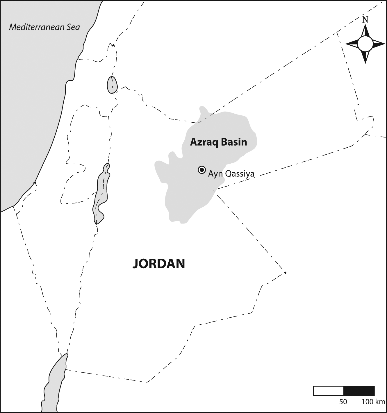
Area map showing the approximate boundaries of the Azraq basin, and the location of the site of Ayn Qasiyya.
Early Epipaleolithic environments
The distribution and composition of ecological opportunities is likely to have had a significant impact on Early Epipaleolithic hunter-gatherers, influencing the ways they used and potentially modified and managed the changing Levantine landscape. Coinciding with the end of the ‘Last Ice Age’, the Early Epipaleolithic was a period of abrupt and fluctuating climate change that significantly affected the distribution of vegetation (Bar-Matthews and Ayalon, 2003; Hillman, 1996; Van Zeist and Bottema, 1991) and other resources such as water sources (Black et al., 2011; Hazan et al., 2005).
In contrast to the favorable micro-mosaic ecology of the Western Levant (Bar-Yosef, 1998), the Eastern Levant during the Last Glacial Maximum (LGM) is considered to have been a marginal, arid environment (Bar-Yosef, 1996). Most of the Early Epipaleolithic sites in the region are small and are interpreted to represent short-term occupations with highly mobile patterns of use. This fits with the accepted idea of increased mobility during this period in response to resource scarcity caused by the LGM (Boyd, 2006). However, in the Eastern Levant, Pleistocene lakes and spring-fed wetlands punctuated the open parkland steppe. Acutely aware of the importance of water in arid regions, Byrd (1994) predicted that settlement in the East would have been organized around periodic wetlands. More recent research has shown that some of these wetlands were more permanent than periodic and, in support of Byrd’s (1994) assessment, served as central foci for Epipaleolithic peoples (Byrd and Garrard, 1989; Cordova et al., 2013; Garrard and Byrd, 2013; Jones and Richter, 2011; Olszewski, 2000; Olszewski and Coinman, 1998; Richter et al., 2013; Rosen, 2012, 2013).
The Azraq Basin (Figure 1) is the location of an extensive spring-fed marsh system, which attracted very large aggregated settlements, including Unwaynid 18 (1200 m2), Jilat 6 (19,000 m2), and Kharaneh IV (21,000 m2). These sites show evidence for increasing cultural and economic complexity, more similar to the Late Epipaleolithic (Natufian) (14,700–11,500 cal. BP) than previously thought (Maher et al., 2012). Hut structures have been identified at Kharaneh IV and Jilat 6 (Byrd, 1988, 1994; Garrard and Byrd, 1992; Maher et al., 2011), suggesting these sites were used as seasonal aggregation camps (Garrard and Byrd, 1992). Sites in the region have also yielded numerous ground stone, marine shell beads, ocher, thermal hot rock features and bone point artifacts (Garrard and Byrd, 1992; Garrard et al., 1987, 1994; Olszewski, 2008; Richter et al., 2011), indicating the existence of complex exchange networks and social interactions, sophisticated food processing, personal adornment practices, and possibly ritual behavior. There is also increasing evidence of complex mortuary practices during this period, suggestive of a growing engagement and long-term connection with landscape and ‘place’ (Maher, 2011). Burial places may have been used to legitimize rights to territories or resources (Byrd and Monahan, 1995; Kuijt, 1996). In line with the overwhelming evidence from cultural material, it might be possible to trace increasingly complex Early Epipaleolithic cultural practice and use of ‘persistent places’ (Olszewski, 2013, personal communication) through evidence of human impact on the environment. However, we must first consider which resources were available in the Azraq Basin marsh system at the close of the Pleistocene.
An important resource base: Wetlands and the phytolittoral zone
Wetlands form an important resource base for hunter-gatherer groups around the world (Nicholas, 1998, 2007a, 2007b, 2013). They can provide reliable perennially available plant resources, both food and other resources, such as building and technological materials, fuel, and water. However, wetlands in arid regions should not always be construed as lush oases or ‘Edens’ (Childe, 1952). Indeed, swamps, marshes, bogs, fens, wet meadows, and shallow water are all broadly defined as ‘wetlands’ – although each has its own unique characteristics (Keddy, 2000: 18), determined mainly by the transition between terrestrial and aquatic habitats. Shallow water, but specifically phytolittoral zones typical of marshes and the edges of some shallow-water environments, are the most vegetatively productive of these environments (Keddy, 2000: 85) (Figure 2). The plants that thrive in this phytolittoral zone include some sedge varieties (Cyperaceae), cattail (Typha sp.), and reed (Phragmites sp.), all of which are of great economic and subsistence value to humans – for the fauna they attract as well as their own nutritional and favorable ecological qualities.
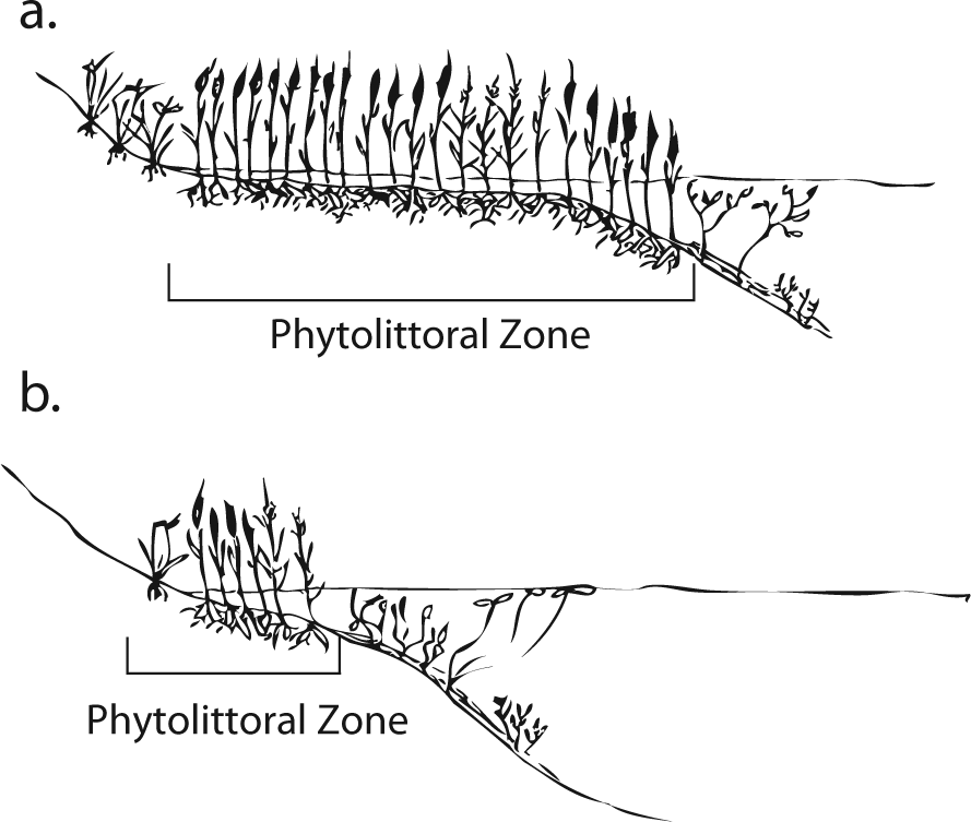
Schematic drawing of wetland margin: (a) phytolittoral zone typical to marsh, illustrating rich resource potential; (b) phytolittoral zone with steeper marginal grade, comparatively less resource potential.
Wetlands, and phytolittoral plants in particular, are often undervalued as a past resource base. Yet, there is compelling comparative archaeological, ethnographic, and experimental ethnobotanical evidence to suggest that phytolittoral resources could have been a critical source of craft and food materials in the Levant during the early as well as later Epipaleolithic as suggested by Rosen (2010, 2013). A particularly relevant ethnographic analogy can be found in the American Great Basin, where Scirpus sp. (bulrushes), Typha sp. (cattails), Phragmites australis (Cav.) Trin. Ex Steud. (common reed), Eleocharis sp. (spike rushes), and Juncas sp. (rushes) were employed as part of a technological complex known as ‘Tule Technology’ (Fowler, 1990). Tule products were used to manufacture cordage, baskets, bags, sandals, duck decoys, cattail houses, and tule bulsa boats (Fowler, 1990: 67, 75), and they were central to resource exploitation in the American Great Basin, both as a material good and as a food resource.
Great Basin peoples also transformed phytolittoral plant resources into a diverse array of edible food sources through the use of simple processing methods. For example, the roots of the bulrush, cattails, and reeds were eaten raw, roasted, or pounded into a meal or flour; the young cattail and reed shoots and stems were eaten fresh; the cattail pollen was roasted; and the seeds of all of these plants, including the rushes, were ground into a flour or consumed whole (see Ebeling, 1986: 115–119; Fowler, 1990: 69–75).
Sea club-rush (Bolboschoenus maritimus (L.) Palla,), a wetland sedge, is often recovered from ancient sites in the Levant and Anatolia. Wollstonecroft’s experimental work with this plant determined that pulverizing its roots greatly increased their nutritional accessibility by disrupting the cell walls, facilitating the softening of the tissues and providing access to intracellular nutrients (Wollstonecroft, 2009; Wollstonecroft et al., 2008, 2011). Her work emphasizes the importance of processing methods for phytolittoral plant-food resources. Wollstonecroft’s findings have led her and her colleagues (Wollstonecroft et al., 2008: 20) to argue that accumulating archaeological evidence for plant-food processing, including increasing numbers of ground stone assemblages (Wright, 1991, 1994) through the Epipaleolithic, suggests that hunter-gatherers were willing to invest more time and labor in plant-processing because ‘they recognized that it could promote abundance’ (Wollstonecroft et al., 2008: 20). This argument is highly relevant to the transformation of phytolittoral resources into edible food staples. Macrobotanical evidence of wetland plant use in the Early Epipaleolithic provides further support for the importance of phytolittoral resources.
Archaeobotanical evidence of Early Epipaleolithic wetland plant use in the Near East
While there is only limited macrobotanical evidence of plant use from Early Epipaleolithic sites in the Near East, two broadly contemporaneous sites with excellent botanical preservation, Ohalo II (ca. 23,000 cal. BP) in Israel and Wadi Kubbaniya (ca. 21,000 cal. BP) in Egypt, demonstrate the importance of phytolittoral plant resources for food and craft purposes.
At Ohalo II, the remains of sedge nutlets (Scirpus littoralis Schrad.) and pond weed nutlets (Potemogeton sp.) suggest these resources were a component of the diet (Weiss, 2002). Whereas the recovery of reed (Phragmites sp.) culm fragments (Weiss, 2002), reed leaves (identified as Phragmites sp. or Arundo sp.) (Nadel et al., 2006), as well as three twisted fiber fragments, which may have been made from a wetland reed, sedge, or rush (Nadel et al., 1994), suggests that phytolittoral resources were employed for craft purposes.
At Wadi Kubbaniya, the remains of root tissue, including nut grass (Cyperus rotundus L.) and sea club-rush, suggest the importance of phytolittoral resources to diet; however, the recovery of sea club-rush tubers and nutlets from charred human feces provides indisputable evidence of their dietary use (Hillman et al., 1989).
In addition, abundant reed and sedge phytolith evidence from the site of Kharaneh IV in the Azraq Basin provides important evidence in the region of study for the central importance of phytolittoral plant resources during the Early Epipaleolithic (Ramsey and Rosen, 2014).
Detecting marsh modification
Building on these works, wetland exploitation appears to be a promising new avenue through which to understand Epipaleolithic subsistence and settlement decisions. Wetlands provide a habitat for several plant species that in theory could be used to trace anthropogenic impacts. Phragmites sp. has the potential to be invasive (Keddy, 2000; Ryan, 2009), and aggressive expansion of Phragmites australis has been linked to anthropogenic disturbance (Chambers et al., 1999, 2003; Cronk and Fennessy, 2001; Keddy, 2000; Keller, 2000; Ryan, 2009). Reed grasses and sedges are common plant taxa found in marsh environments. Importantly, they produce large amounts of phytoliths including both multi-cell and single-cell forms – some of which are diagnostic to genus and/or species (Metcalf, 1960; Ollendorf, 1992; Ollendorf et al., 1987; Ryan, 2009). Accordingly, it might be possible to use the abundance trends in reed-grass phytoliths, as part of a multi-proxy approach to identify anthropogenic disturbance in wetland environments.
Micro-charcoal analysis, the study of microscopic charcoal particles, has been employed around the globe to reconstruct fire events (Power et al., 2008). Fire events produce a pulse in charcoal, which is transported away from the fire site by wind and water wash. Microscopic charcoal (i.e. particles less than 180 µm) provides a robust indicator of past fire activity because of its resistance to chemical and biological mechanisms of degradation (Turner, 2007). Turner (2007: 58) notes that sustained peaks in microscopic charcoal which are considerably larger than the background level of charcoal may reflect fires occurring within the vicinity of the core location, providing evidence of the spatial resolution of the fire event. Unlike phytolith assemblages, which are formed by the in situ deposition of plants providing a highly localized reconstruction, micro-charcoal assemblages are subject to complex dispersal processes (Patterson et al., 1987). However, the main agents of dispersal, wind and water, are largely mitigated when the source of the charcoal is the vegetation growing on or in the basin in which it is preserved (Patterson et al., 1987). Such is the case for those phytolittoral plants in a marsh setting, such as reeds and sedges.
Combining phytolith and micro-charcoal analyses to identify human impact in a marsh setting is a promising approach because it plays to the strengths of both data sets. Unlike other archaeobotanical methods, phytoliths can provide evidence of leaf and stem plant parts and are therefore sensitive indicators of impact in the reed beds. Phytoliths decay and preserve largely in situ, which means that the phytolith record is highly localized. Moreover, phytoliths preserve in both charred and non-charred contexts, allowing us to consider a wider range of anthropogenic disturbance possibilities (disposal of trash, collection of plant, and animal marsh resources including gathering for food, basketry, thatching, or fuel resulting in unintentional marsh trampling). While micro-charcoal signatures are strongly regional, pulses in micro-charcoal quantities can suggest a local fuel source. By correlating the trends in the phytolith data, which provide evidence of the local vegetation, with the pulses in the micro-charcoal assemblage, which provide evidence of local and regional fire activity, it might be possible to identify local fire events.
This paper presents the preliminary results from a phytolith and micro-charcoal study conducted on a geoarchaeological section (section 1) located on the site of Ayn Qasiyya (Figure 3), an Early Epipaleolithic site in the Azraq Basin. Employing a multi-proxy approach, we identify trends in the local marsh ecology (via phytoliths), and reconstruct the fire history (via micro-charcoal). The methods employed in this study were inspired by several recent papers, including Turner et al. (2010) and Cordova et al. (2013), that use a correlation between phytolith and micro-charcoal data to infer past human impact on the environment. With that in mind, we will first investigate the data to determine whether or not there is evidence for local fire events or other disturbance in the marsh during the Early Epipaleolithic. Second, we will assess the possible sources of disturbance, with the view to identifying anthropogenic impacts on the marsh during the Early Epipaleolithic period.
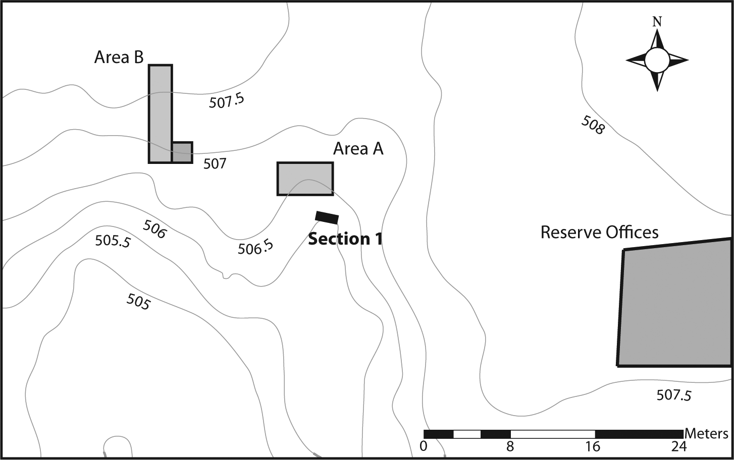
Detailed plan of Ayn Qasiyya showing location of excavation trenches and sections (Redrafted from Richter, 2009: 137).
Regional setting
The Azraq Basin is characterized by a series of wadi tributaries, spring-fed contexts, and depressions totaling ca. 12,000 km2. The region receives an average yearly rainfall of 84 mm, with mean annual rainfall declining from the northwest toward the southeast. The Azraq Oasis itself is fed by a number of springs. According to spring discharge data and groundwater levels, there appears to be a clear relationship in the basin between groundwater level in the aquifers and discharge in the Azraq oasis (Jones and Richter, 2011: 365). Indeed, the water in this system has a very long residence time, or a low discharge to recharge ratio. This means that changes in spring flow intensity in part reflect changes in rainfall thousands of years prior. Until the early 1990s, these springs were associated with two extensive marsh areas. The North Azraq Marshes, the smaller of the two covering about 1.8 km2 and the Southern Marsh, fed by the springs at Ayn Soda and Ayn Qasiyya, covered a total area of ca. 5.6 km2. Surface water in the Azraq Basin is collected within mudflats, the largest of which is the Azraq Qa’, which can extend to an area of 50 km2 and can reach depths of 2 m (Nelson, 1973; Richter et al., 2007). Under present conditions, this shallow lake dries quickly because of increasing evaporation caused by rising spring temperatures and usually disappears by mid to late spring or early summer. It also turns increasingly saline in the process (Yogeshwar et al., 2013).
The Azraq Oasis has a long history of human occupation throughout the Pleistocene. Scholars have suggested that the many springs and marshes may have served as a refuge during and shortly after the LGM and at other points during the Paleolithic (Copeland and Hours, 1989; Cordova et al., 2013; Garrard and Byrd, 2013; Jones and Richter, 2011). Such wetland environments are believed to have provided hunter-gatherers with reliable water and food resources during the climatic duress of the various glacial periods. In support, recent geoarchaeological studies in the Southern Marsh (Cordova et al., 2013; Jones and Richter, 2011) have demonstrated that during the Early Epipaleolithic, particularly during the LGM, the locale was host to a rich marsh environment, comparable with the recent oasis (Figure 4). The implication being that during the height of the LGM, a period characterized by cold conditions with variable precipitation (Hunt and Garrard in Garrard and Byrd, 2013), this shallow-water habitat would have been a zone of more predictable resources as compared with the surrounding semi-arid steppe zone. Moreover, the marsh would have provided an ideal environment for the exploitation of diverse wetland resources, both plant and animal.
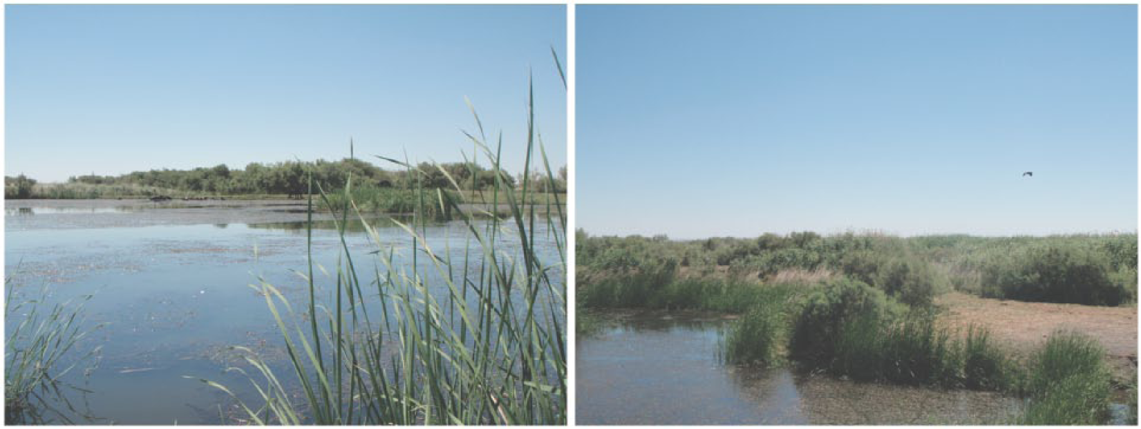
Azraq wetland reserve, 2012. This restored wetland illustrates what the environment around the site of Ayn Qasiyya might have looked like during the Early Epipaleolithic.
Ayn Qasiyya
The archaeological site of Ayn Qasiyya (Figure 3) is named after the second largest spring in the Southern Azraq Marshlands. It is situated ca. 150 m north of the largest south Azraq spring, Ayn Soda. Dating to 22,564–20,648 cal. BP and 19,473–17,405 cal. BP, an occupation period spanning ca. 2500 years (Richter et al., 2013), Ayn Qasiyya offers a rare opportunity to gain a more detailed insight into Early Epipaleolithic exploitation of the Azraq wetland during the LGM.
The site was excavated in three seasons between October 2005 and August 2007 (Richter and Röhl, 2005; Richter et al., 2007, 2010a, 2010b). As part of this research, the site was subject to a geoarchaeological study (see Jones and Richter, 2011), which has provided a well-dated sequence and information on the paleoenvironment, water level, and spring flow at the site. To generalize from top to bottom, the sequence consists of a very compact carbonate-concreted topsoil of varying thickness, followed by a series of clayey-silts with a highly organic content (marsh deposits). They contain abundant lithic artifacts and animal bone, none of which appeared sorted, ordered, orientated, or laid down at a horizontal incline. However, the clayey-silt marsh deposits are associated with an exclusive Early Epipaleolithic chipped stone industry (Richter et al., 2007). The marsh deposits overlie a substantial laminated silty-clay deposit, which is of lacustrine origin and appears to be associated with a substantial lake present in the area prior to human occupation.
The archaeologically rich marsh deposit is not horizontally continuous throughout the site. Richter (2014, personal communication) suggests this discontinuity may reflect the edge of the wetland environment, or a stable land surface in some places, perhaps small islands or raised areas, which may have provided suitable occupation zones. It seems unlikely that a marsh itself would have formed the principal occupation area for inhabitants at Ayn Qasiyya. Richter (2014, personal communication) describes the accumulation of archaeological material within the marsh deposit as reflecting sporadic use of the inundated wetland, combined with dumping or waste disposal from the adjacent terrestrial surfaces that he suggests formed the actual occupation zones. In addition to artifacts, the semi-articulated remains of a 35- to 45-year-old male were recovered from the final stage of marsh deposits, indicating the importance of this site to its Early Epipaleolithic inhabitants (Richter et al., 2010b).
Data and methods
Dating, chronology and sampling: Section 1
The geoarchaeological section (Figure 5) was chosen for this preliminary study for several reasons: First, it is a well-dated sequence, with several OSL and radiocarbon dates (see Jones and Richter, 2011); second, contiguous samples were taken from section 1 to allow for sedimentological analysis; and third, the section clearly shows that during the Early Epipaleolithic, the period of interest for this study, there was a well-developed marsh environment. This setting provides us with the opportunity to potentially observe small-scale anthropogenic impacts on the marsh, with the marsh itself, protecting and accumulating evidence of the immediate plant ecology (phytolith record), and the local to regional fire history (micro-charcoal assemblage).
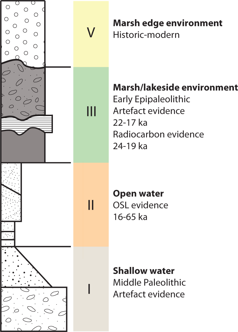
Section 1 profile (Redrafted from Richter, 2009: 156).
Section 1 was classified by Jones and Richter (2011) according to four stratigraphic units which indicate different micro-environmental conditions. Units I and II, dated to the Middle Paleolithic, correspond to a period of increased spring activity and open water at the site. Water levels then fell during the LGM, suggesting that the spring output was reduced or reducing, facilitating the development of a marsh (Unit III) through the Early Epipaleolithic (22,564–20,648 cal. BP and 19,473–17,405 cal. BP) (Richter et al., 2013). Between 16 and 10.5 ka BP, there was a hiatus in sediment deposition, suggesting the onset of a less favorable environment. It is possible that the springs dried out during this period. Unit V has been relatively dated to the late-Holocene. This is corroborated by an OSL age determination on this same unit from ‘Ayn Soda’ (Cordova et al., 2013). Carbonate concentrations in this unit suggest warm conditions and spring activity (see Jones and Richter (2011) for more details).
The archaeological deposits at Ayn Qasiyya are contained within Unit III, a former marsh deposit, analogous to those forming in the present day wetland reserve. The stratigraphy of Unit III is described by Jones and Richter (2011). The base of the unit contains a series of banded black to dark gray organic-rich sandy to silty sediments, over which there is a layer of lighter colored fine sand. The top of the unit, like the base, is composed of a black to dark gray organic-rich sandy to silty sediment, but additionally includes larger flint and bone fragments (>5 cm). The intrusion of the lighter colored fine-sand sediments may reflect a period of increased fluvial or spring activity. The coarser sand particles suggest a moderately higher energy depositional environment. The marsh environment of Unit III was inundated by shallow water over extended periods of time, creating an ecological ‘trap’ that accumulated evidence of both human and environmental inputs. This geoarchaeological context has provided a rare record for this time period in the Eastern Levant that allows us to investigate the evidence for local fire events and other disturbances in the marsh, and perhaps ultimately identify anthropogenic impacts on the marsh during the Early Epipaleolithic period.
Phytolith analysis
Phytoliths were extracted from the sediments following Rosen’s (1999) protocol, which employs a series of techniques to remove carbonates, clays, and organics before extracting the phytoliths. First, the sediment was sieved though a 0.25 mm mesh to remove the coarse sediment fractions. An aliquot of approximately 800 mg was then taken for analysis. The sample was treated with 30 mL of 10% hydrochloric acid (HCl) to remove the carbonates. To disperse the clays, a sodium hexametaphosphate solution (lab grade Calgon and distilled water) was added to the sample. The clays were removed from the sample by decanting after settling the fine sands and silts. This process was repeated until the suspension was clear. Organic matter was removed by dry-ashing the samples in a muffle furnace for 2 h at 500°C. The phytoliths were then extracted from the remaining fraction using heavy density separation. A sodium polytungstate (SPT) solution (with distilled water) calibrated to 2.3 specific gravity was used to separate the phytoliths from the heavier minerals. The phytoliths were then poured off, cleaned, weighed, and mounted in Entellan. The phytolith slides were counted at 400× magnification using a transmitted-light microscope. Absolute counting methods were employed, and a minimum of 300 single cells was counted on each slide. The results are expressed as number per gram of sediment. Because there were so few multi-cell phytoliths in the Ayn Qasiyya sediments, the multi-cell evidence is referenced in a qualitative, rather than quantitative, manner.
Micro-charcoal analysis
Micro-charcoal was extracted from the sediment following Turner’s (2007) density separation method, which Turner et al. (2008) found experimentally to have a higher recovery than other published methods for the fine charcoal fraction, and more than 10 times the recovery of the standard pollen preparation method. A quantity of 2 g of sediment was disaggregated overnight in 100 mL distilled water in a 400 mL beaker. The samples were then wet sieved (0.18 mm) and treated with 30 mL of 10% HCl for 30 min. Two Lycopodium tablets (18,583 spores per tablet, batch 483216) were then added to the sediment as a counting spike. To clean the HCl from the samples, 200 mL of distilled water was added. Once the sediments settled, the water was pipetted off. Using a hot plate, the excess water was evaporated off without letting the sample to dry out. The samples were then washed out of the beakers into a 15 mL centrifuge tube with 10 mL of SPT calibrated to a specific gravity of 2.5 and centrifuged for 10 min at 800 r/min. The top pellet, which contained the micro-charcoal, was then poured into a 400 mL beaker and 200 mL of distilled water was added. Once the sample settled, the water was pipetted off. This was repeated twice. After the last pipetting, the samples were transferred to 5 mL vials and glycerol was added at a 1:1 ratio. A sample of the solution was then mounted. The micro-charcoal slides were counted at 200× magnification using a transmitted-light microscope. Micro-charcoal was counted until a predetermined number of Lycopodium spores were recorded. Turner (2007: 59) found that reliable counts were obtained with a count of 100 spores. The raw counts were converted to absolute counts per gram of soil using the following equations:
Charcoal concentration (whole sample) = (exotic spore added × charcoal counted)/exotic spore counted
Charcoal concentration per 1 gm = (1/sample weight) × charcoal concentration (whole sample)
Micro-charcoal was identified based on a set of diagnostic criteria, mainly the requirement that they had to be jet black in color, with straight edges and with the presence of a blue hue on the edge (Turner et al., 2008). Following Innes et al. (2004), charcoal particles of about 30 µm in diameter were considered the basic measurement unit (30 µm = one). Being similar in size to the Lycopodium spike, this made for a quick and easy estimate while counting. Larger fragments were counted according to how many 30 µm ‘portions’ they contained (e.g. 90 µm portions = three); smaller fragments were aggregated to form this measurement (two 15 µm portions = one). However, particles smaller than approximately 5 µm were not counted. This method of counting was employed as a time-effective compromise to avoid overrepresentation of charcoal as a result of potential fragmentation.
Results and discussion
Phytolith and micro-charcoal analysis
A total of 23 sediment samples were analyzed for phytoliths in this study. All of the samples were taken in vertically contiguous 5 cm units, except for the uppermost four samples (AQ.14.1-4) that were taken in contiguous 10 cm units; 18 of the samples (AQ.14.5-22) were processed and analyzed for micro-charcoal. This high-resolution sampling (5 cm units aside from AQ.14.1-4) provides a general picture of the plant ecology from a broad chronological horizon.
The phytoliths throughout the section show some minor signs of pitting and dissolution. This suggests that the phytoliths may have been subject to certain taphonomic effects, which could include mechanical breakage, perhaps from alluvial or fluvial forces, and some chemical dissolution. Since the depositional environment was most likely low energy (Jones and Richter, 2011), it is therefore more likely that the phytoliths were exposed to periods of higher pH, perhaps the result of increasingly saline or brackish conditions. Phytoliths can preserve indefinitely in most environments; however, they are sensitive to highly alkaline conditions of pH 9+ (Mulholland and Rapp, 1992). The Azraq Basin is currently prone to becoming saline or alkaline during periods of increased evaporation. It is possible that the wetland was subject to similar dynamics in the past. However, we believe that the level of pitting/dissolution is not pronounced enough to have significantly affected the phytolith assemblage.
More general effects of sedimentation and taphonomy might also have influenced the phytolith and micro-charcoal assemblages in this geoarchaeological section. Indeed, in open-water environments such as those in Units I and II, these microbotanical remains may accumulate in several ways. First, they could have been deposited through eolian transport, as part of the silt movement in the region; second, through the deposition of plant debris in the water column; or third, through the output from vegetation fires. However, in a shallow-water environment where plants are growing, such as Unit III, only the first and third mechanisms might apply. However, the growth of vegetation in this unit introduces a new in situ source of phytoliths and micro-charcoal. Finally, human activity provides another layer of complexity that bears consideration. The impact of this myriad of complicating factors requires further exploration, beyond the scope of our current data set. However, the main purpose of this analysis is to identify and trace general wetland processes and dynamics, a task the current data set is situated to address.
Figure 6 shows the trends in micro-charcoal, key phytolith morphotypes, and the total phytolith density per gram of sediment throughout section 1. The densities of significant phytolith morphotypes plotted include bulliforms, keystone bulliforms (also known as ‘fan-shaped’ bulliforms) (cf. reeds); ‘cones’ (from sedges); ‘rondels’ (C3 grasses); ‘sheets’ (dicot leaves); and ‘silica aggregates’ (dicot wood).
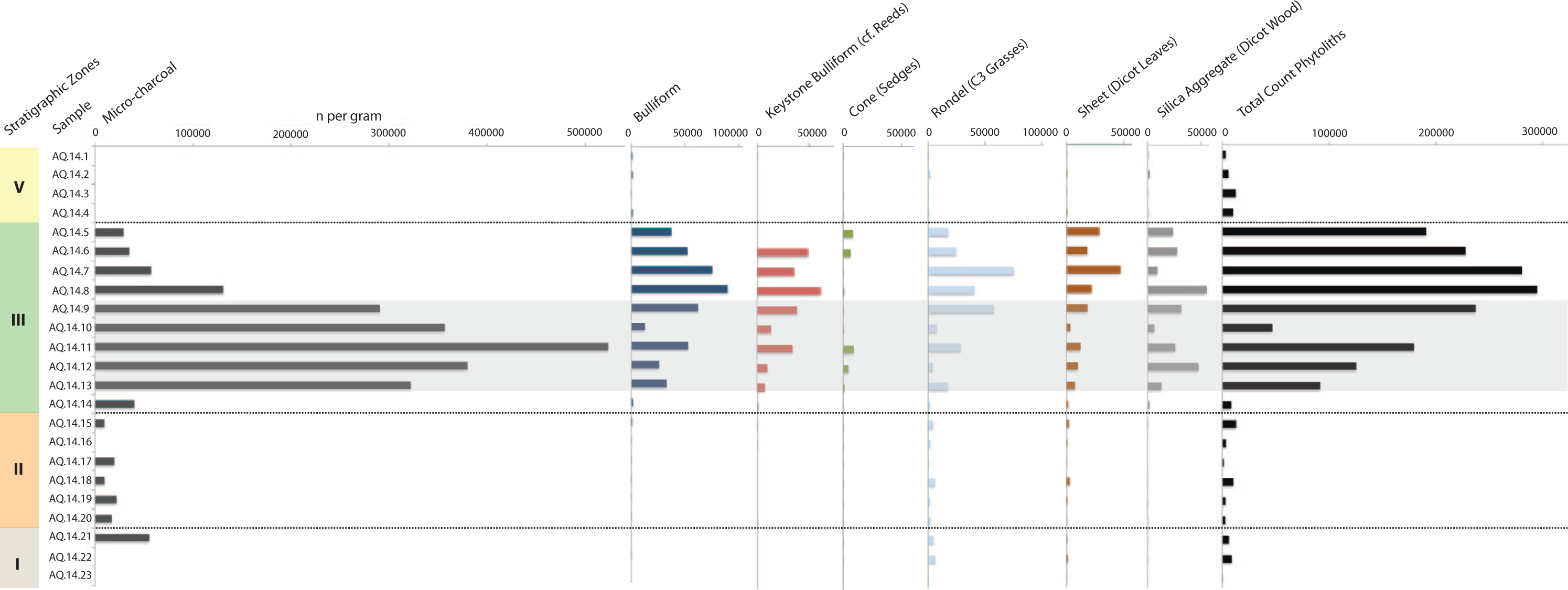
Section 1 phytolith and micro-charcoal data. Horizontal axis indicates the number per gram of sediment.
Units I and II (AQ-14-23 to AQ-14-15) span the period prior to the development of the marsh deposits, from the Middle Paleolithic through to the Early Epipaleolithic (OSL evidence 16–65 ka BP), during which time the density of phytoliths remains comparatively low, although there are some fluctuations in the phytolith densities (600–10,000 phytoliths per gram of sediment) among the samples. All of the samples are primarily composed of phytoliths derived from monocots, and in particular rondels, clearly demonstrating a predominance of cool season C3 grasses (see percentages in Figure 7). However, there is also a large proportion of sheets, as well as an increase through time in the bulliforms and keystone bulliforms.
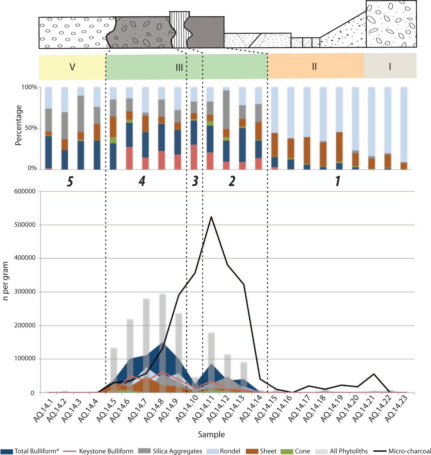
Five ‘zones’ of interest are identified using the section 1 profile, stratigraphic units, phytolith, and micro-charcoal data. The bottom graph compares the phytolith and micro-charcoal counts (number per gram of sediment). The upper graph presents the percentages of the different phytolith morphotypes in each sample. In the bottom graph, the n per gram for the bulliforms is displayed as a combination of the highly correlated bulliforms and keystone bulliforms, but keystone bulliforms are also displayed separately. In the upper graph, the bulliforms and the keystone bulliforms are displayed separately.
Unit III (AQ-14-14 to AQ-14-5) spans the Early Epipaleolithic period (artifact evidence 22–17 ka BP, radiocarbon evidence 24–19 ka BP). The phytolith density ranges between approximately 2400 phytoliths per gram of sediment (AQ-14-14), and spikes to around 150,000 (AQ-14-8). The spike in phytoliths seen in AQ-14-8 is the result of an overall increase in all of the main phytolith morphotypes. However, bulliform and keystone bulliforms dominate all of the samples in unit III. Bulliforms are not necessarily diagnostic as they are found in the leaves of all grasses, including reeds. However, the bulliform and keystone bulliform (cf. reeds) phytoliths are highly correlated (0.85) in Unit III, which suggests that all of the bulliforms originate mainly from reed vegetation. The overwhelming number of bulliforms and keystone bulliforms marks a clear transition from the previous units.
The peak in micro-charcoal, associated with the earlier portion of Unit III (Early Epipaleolithic), is charted horizontally across Figure 6 by the gray trend band. This peak suggests that there was an increase in local fire activity during this period. However, the trends in micro-charcoal (Table 1) do not clearly correlate with any particular phytolith morphotype, suggesting that the fire events were non-discriminate, burning the local vegetation generally – and not only the reed beds.
Correlation coefficient results.
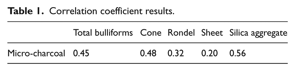
Yet, following this peak in micro-charcoal, there is a clear peak in phytolith density in Unit III, the Early Epipaleolithic marsh environment. This peak demonstrates a rapid expansion of vegetation. While a significant increase in vegetation is not unexpected with the development of a marsh environment since marshes have particularly high primary productivity (Keddy, 2000: 59), because of their typically extensive phytolittoral zones, it is notable that this accelerated peak of vegetation follows a period of increased fire activity. While all of the phytolith morphotypes contribute to the vegetation expansion, it is clear that bulliforms and keystone bulliforms from reed grasses overwhelm the assemblage in Unit III.
Unit V (AQ-14-4 to AQ-14-1) is dated to the late-Holocene. In this final unit, the proportion of phytolith morphotypes changes significantly from unit III, with keystone bulliforms largely disappearing from the assemblage. Notably, however, bulliforms remain a significant portion of the assemblage. Importantly, in Unit V, keystone bulliforms and bulliforms are very poorly correlated (0.11), suggesting that in this unit, the bulliforms originate from other grass taxa. The density of phytoliths also drops dramatically in unit V, ranging between approximately 400 and 1200 phytoliths per gram of sediment.
Marsh history reconstruction
Figure 7 draws together the various lines of evidence employed in this paper. The bottom graph compares the absolute counts (n per gram sediment), and the middle graph presents the percentages of the different phytolith morphotypes in each sample. Percentages are useful in illustrating general vegetation shifts through time. In so doing, it is possible to identify five ‘zones’ of interest. The zones have been marked and labeled in Figure 7 and will now be described.
Zone 1 corresponds to the lower portion of the section, dating to the Middle Paleolithic. The phytoliths indicate that during this period, the environment was composed mainly of cool season grasses and dicots, suggestive of a dry steppic/parkland environment. However, with the development of the marsh, there was an increase in wetland vegetation, mainly reeds, indicated by the highly correlated (0.85) bulliform and keystone bulliform phytoliths.
Zone 2 corresponds with the earliest level of the marsh, which dates to the Early Epipaleolithic. The micro-charcoal results indicate it is characterized by increased evidence of local fire event(s). Natural fires can occur in marsh environments, particularly during both drier and wetter periods (Keddy, 2000: 291). Indeed, ‘banding’ apparent in the section profile is suggestive of a series of pedogenic horizons, and might suggest fluctuating water levels in the marsh. However, this spike in charcoal is also a possible signal of human land-use in the marsh, coinciding as it does, with increasing intensity of human occupations in the region (Garrard and Byrd, 2013). Phytolith evidence indicates that the marsh vegetation included a balance of reeds, sedges, and dicots (woody shrubs), although the reed beds were expanding. It is possible that the invasive and aggressive characteristics of reed-type vegetation, such as Phragmites, facilitated the expansion of the reed bed under the increasing fire disturbance, as evidenced by the micro-charcoal assemblage. Burning (natural or anthropogenic) may have hindered the expansion of dicot and sedge vegetation (Keddy, 2000: 295), providing the reed beds the opportunity to develop into dense, deep-rooted, stands that could then continue to out-compete the smaller plant varieties, including many dicots and sedges.
Zone 3 also dates to the Early Epipaleolithic, and corresponds with the interruption of lighter colored fine-sand sediments observed in the section profile. The phytolith assemblage suggests a clear recession in the vegetation. It is possible that the depositional forces that resulted in the sandier deposit also disturbed the general vegetation. However, the reed beds increase in proportion to the other plant taxa during this period, indicating that the increased depositional energy could have been the result of amplified spring activity. The micro-charcoal assemblage suggests a continued decrease in fire events.
Zone 4 also dates to the Early Epipaleolithic and is composed of a black to dark gray organic-rich sandy to silty soil, and includes larger flint and bone fragments (>5 cm). This suggests more intensive human activity in the marsh. The phytoliths indicate an increasingly dynamic environment throughout this zone, with a substantial peak in the reed beds, indicated by the bulliforms and keystone bulliforms (AQ.14.8), and an appreciable rise in the C3 grasses and woody dicots as well. There is then a drop in the reed bed (AQ.14.7), and then another peak in the reeds (AQ.14.6), followed by a final drop in the reeds (AQ.14.5) and a slight increase in the sedges. It is possible that the pronounced peaks and troughs in the vegetation and the reeds in particular are the result of increasing human land-use practices in the marsh – perhaps reflecting a range of anthropogenic disturbance possibilities, including exploitation of the reed beds for food, basketry, thatching, or fuel. The micro-charcoal density continued to drop, suggesting a sustained decrease in fire events throughout this zone. Zone 4 culminates with a rise in the dicots, as indicated by the sheet phytoliths – perhaps the result of decreasing fire activity. This peak marks the transition to Zone 5, and the recession of the marsh.
In Zone 5, the vegetation drops dramatically. This may be linked to the complex depositional environment that prevailed after the recession of the Epipaleolithic marsh. Periods of sediment deflation and deposition accompanied by changing water levels against the warmer climate of the Holocene would have resulted in the re-modeling of the marsh’s edge. The drop in phytolith density suggests that although the spring was re-established and modern marsh conditions prevailed in the late-Holocene, the vegetation did not re-colonize to the same extent as during the LGM.
Evaluating disturbance: Findings and future work
The findings in this paper suggest that there is evidence for local fire events and other disturbance in the marsh during the Early Epipaleolithic. Examples of potentially large-scale human impacts on the environment, including anthropogenic burning and vegetation clearance, have been suggested for even earlier periods than those discussed here, for example between ~50–35 ka BP in South East Asia and Australasia (Hunt et al., 2007; Kershaw et al., 2003; Summerhayes et al., 2010). However, distinguishing between natural or anthropogenic fires is a difficult, if not impossible, task.
Whatever the cause at Ayn Qasiyya, the potential ramifications of increasing fire disturbance on the marsh, such as facilitating the expansion of invasive reed beds, would have had clear benefits for Early Epipaleolithic hunter-gatherers. Reed bed expansion would have provided a valuable and reliable source of thatching, basketry, fuel, and food. Many of the plant species that characteristically form the reed bed, including Phragmites sp., have edible roots and stems. Reed beds also form an important habitat for wetland birds and other game. These valuable characteristics, along with the spring itself, might have encouraged the repeated occupation of Ayn Qasiyya (~2500 years). Increasing lithic and faunal evidence in Zone 2–4 suggests escalating use of the marsh. Correlated phytolith trends, including dramatic peaks and troughs in the bulliforms and keystone bulliforms, provide for the compelling possibility that increasingly intensive human activity, including exploitation of the reed bed, resulted in both the suppression and expansion of the reed bed at different times, ultimately developing into an increasingly complex anthropogenic-driven dynamic in the marsh.
The Azraq Basin has long served as a desert refuge (Copeland and Hours, 1989; Cordova et al., 2013; Garrard and Byrd, 2013; Jones and Richter, 2011). Accordingly, it is probable that increasingly regional arid conditions at the height of the LGM encouraged Early Epipaleolithic settlement in the wetlands (Cordova et al., 2013; Garrard and Byrd, 2013; Jones and Richter, 2011). Our data presented here provide an interesting hypothesis to be tested by ongoing work in the region. Through their exploitation of the marsh for reliable resources, Early Epipaleolithic peoples may have triggered ecological feedbacks in the wetland, including reed bed development. Expansion of this critical resource might have facilitated and fostered continued Epipaleolithic exploitation and settlement in and around the marsh. Within this increasingly intensified anthropogenic landscape, the social and cultural connection to certain locales might have promoted the development of ‘persistent places’ (Olszewski, 2013, personal communication), and eventually large aggregation settlements. Significantly, this hypothesis suggests that the origin of ‘persistent places’ and larger aggregation settlements in the Azraq Basin was in part facilitated by earlier human–environment interactions that consequently enhanced the economic, and subsequently social meaning of that landscape – a landscape that was increasingly impacted by subsequent generations of people.
Conclusion
Our evidence from Ayn Qasiyya raises the possibility that through their exploitation of the marsh, and in particular the anthropogenically sensitive reed beds, Epipaleolithic hunter-gatherers were modifying the marsh and initiating long-term changes to the already dynamic and changing landscape at the close of the Pleistocene. These findings support growing recognition of the importance of wetlands for Epipaleolithic subsistence and settlement, and in so doing provide another example of behavioral continuity between earlier and later Epipaleolithic periods (Maher et al., 2012) and beyond. This continuum challenges us to continue to critically reconsider the way we see early hunter-gatherers in the prehistory of the Levant and in the development of the Anthropocene.
Footnotes
Acknowledgements
Ideas, like the Azraq springs, have a wide catchment area. Accordingly, we must acknowledge and thank Dr Deborah Olszewski, Professor Karl Butzer, and all of the participants from the Anthropocene in the longue Durée conference, for their thoughtful comments and critique, which greatly improved an initial draft of this paper. This paper also greatly benefited from guidance and advice from Dr Rebecca Turner, Dr Philippa Ryan, and two anonymous reviewers. Finally, many thanks must also be extended to Professor Vaughn Bryant at Texas A&M for providing a speedy supply of surprisingly rare Lycopodium tablets, the micro-charcoal portion of this research would not have been possible without his neighborly advance.
Funding
This work was supported by the Social Sciences and Humanities Research Council (award number 752-2011-1728) and a National Science Foundation SBE DDRIG (grant number BCS-1418462).