



Abstract
Using a combination of 23 radiocarbon ages and annual ring counts from 18 Rocky Mountain bristlecone pine (Pinus aristata) remnants above the local present-day limits, a period of higher treeline has been determined for two sites near the Continental Divide in central Colorado. The highest remnants were found about 30 m above live bristlecone pines of similar size. The majority of the remnants, consisting of standing snags, large logs, and smaller remains, are highly eroded, such that the innermost annual rings of all but one are missing. The radiocarbon ages obtained from the oldest wood recovered from each remnant indicate that the majority were established above the present-day limit of bristlecone pine from prior to 2700 cal. yr BP to no later than about 1200 cal. yr BP. These radiocarbon ages combined with the annual ring count from the corresponding remnant indicate that the majority of the sampled remnants grew above the present-day limit of bristlecone pine from sometime before 2700 cal. yr BP to about 800 cal. yr BP. Evidence of recent climatic warming is demonstrated at one of the sites by young bristlecone pine saplings growing next to the highest remnants; the saplings were established after AD 1965 and represent the highest advance of treeline in at least 1200 years.
Keywords
Introduction
The altitude of upper treeline in the mid-latitudes of the Northern Hemisphere is primarily controlled by the length of the growing season and daily maximum temperatures (Arno and Hammerly, 1984; Tranquillini, 1979). Hence, the altitude of former treelines provides information about past growing season temperatures. In Colorado, direct evidence of past higher treelines has been obtained from logs recovered from shrinking ice patches (Benedict et al., 2008), bogs (Carrara, 2011), or simply lying on the alpine tundra as in this study.
Rocky Mountain bristlecone pine (Pinus aristata) can sometimes be found near treeline on xeric sites, commonly on steep, south-facing slopes with shallow, rocky soils exposed to strong westerly winds (Brunstein, 2006; Brunstein and Yamaguchi, 1992; Krebs, 1972; Peet, 1978). At some of these sites, bristlecone pine remnants lying on the ground as well as standing dead remnants above the local present-day treeline have been observed by the senior author. This species is known to live for as long as 2500 years (Brunstein, 2006; Brunstein and Yamaguchi, 1992), in part because of the low density of trees and the general lack of litter and ground vegetation that limit the spread of fires and disease at the high-elevation sites where these trees grow (LaMarche and Mooney, 1967). In addition, the tree’s longevity is due in part to the wood’s extreme durability as the wood is very dense and resinous, and thus resistant to invasion by insects, fungi, and other potential pests. As the tree ages, much of its vascular cambium layer may die and the overlying bark falls off. In very old specimens, often only a narrow strip of living tissue connects the roots to a handful of live branches (Brunstein, 2006). Unlike the wood of the other Colorado treeline species such as Engelmann spruce (Picea engelmannii) and subalpine fir (Abies lasiocarpa), which can rapidly decay, bristlecone pine wood can remain for as long as several thousand years after the tree has died (LaMarche and Mooney, 1967; Lloyd and Graumlich, 1997). Because of cold temperatures, dry soils, high winds, and short growing seasons, the trees grow very slowly.
In Colorado, Rocky Mountain bristlecone pine currently grows in at least 65 stands, primarily on the eastern side of the Continental Divide from about 2750 m in elevation to treeline at about 3650 m (Baker, 1992; Krebs, 1972). The tree can be found in the Front Range, Mosquito Range, Sawatch Range, San Juan Mountains, and the Sangre de Cristo Mountains (Krebs, 1972; Lanner, 2007). In this study, two sites (Alma and Boreas Pass) were investigated near the Continental Divide in central Colorado (Figure 1) where bristlecone pine remnants were found above present-day treeline. In addition, at the Alma study site, small bristlecone pine saplings were scattered among the remnants indicating a recent ongoing advance to establish a new and higher treeline.

Regional map of central Colorado showing location of the Alma and Boreas Pass study sites.
The authors originally thought that the bristlecone pine remnants in this study might have been established during the ‘Medieval Warm Period’, about AD 950–1200 (about 1000–700 cal. yr BP) (Grove and Switsur, 1994). During this period, it is thought that the southern Rocky Mountains were characterized by a longer growing season and greater winter and summer precipitation than that of today (Petersen, 1994), conditions considered favorable for an advancement of treeline. Areas that cannot be dry-farmed today were commonly farmed by the Ancestral Puebloans of southwestern Colorado during this period (Petersen, 1994). Therefore, the remnants of this study provide information concerning the timing and effects of a more favorable climate that allowed the establishment of a higher-than-present treeline and may serve as a proxy of the effects of a future warmer climate.
Climate in vicinity of the study sites
Although there are no climate stations at the study sites, climate records from January 1893 to May 2012 from the former town site of Climax (Figure 1), at an altitude of 3460 m, about 12 km northwest of the Alma site, near the Continental Divide, give a good representation of climatic conditions at the sites. Average annual precipitation is about 63 cm; maximum precipitation occurs in winter and spring (December–May) and during the summer thunderstorm season (July and August). Average January temperatures are −10.3°C, and July temperatures average 11.0°C. The lowest temperature on record is −36°C, which occurred on 12 January 1963. The highest temperature on record is 29.5°C, which occurred on 7 July 1981 (Western Regional Climate Center, unpublished data accessed 9 July 2012, on the World Wide Web at URL http://www.wrcc.dri.edu/summary/Climsmco.html).
Strong winds are common at altitudes above treeline throughout the winter months and can exceed 80–160 km/h in exposed locations (Doesken et al., 2003). Such locations are free of snow during much of the winter. Both the Alma and Boreas Pass sites are subjected to high winds such that wind blasting by sand and snow has eroded the windward (western) sides of the trees removing the bark (cambial dieback) and much of the underlying wood, including the pith region. This is further indicated in that many of the living trees have a flagged appearance, such that on the windward side of the trees there are usually fewer living branches. The surviving branches are smaller and shorter than those on the more sheltered eastern side of the trees indicating strong westerly winds.
Study sites
During an initial reconnaissance, in 2008, of subalpine areas near treeline in Colorado, approximately 10 sites were identified where bristlecone pine remnants existed above the present-day treeline. Sites visited included those in the Colorado Front, Mosquito, and Sawatch Ranges. Two sites, one near the town of Alma and the other near Boreas Pass, were chosen for their ease of access and proximity to Denver.
Alma site
At a site about 4 km north-northwest of the town of Alma in the Mosquito Range (Figure 1), bristlecone pine remnants, consisting primarily of logs, ranging from 2.5 to 6 m in length, lying on the ground (Figures 2 and 3) were found at elevations between 3652 and 3677 m. In addition, two weathered and eroded standing snags were found lower on the site at an elevation of 3648 m. The site is on a steep, south-facing slope with sparse tundra vegetation and underlain by a light gray to light-bluish-gray quartz monzonite porphyry of Eocene age (Widmann et al., 2004). Most of the remnants appear to be from single-stem trees that are today growing about 30 m lower in elevation than the highest remnants. The highest live patches of krummholz Engelmann spruce and subalpine fir are at an elevation of 3660 m. The highest live single-stem bristlecone pine (treeline) is at an elevation of 3645 m, while the elevational limit of full-sized bristlecone pines (timberline) is at about 3612 m. In this stand, Krebs (1973) established a chronology extending back to AD 1138.
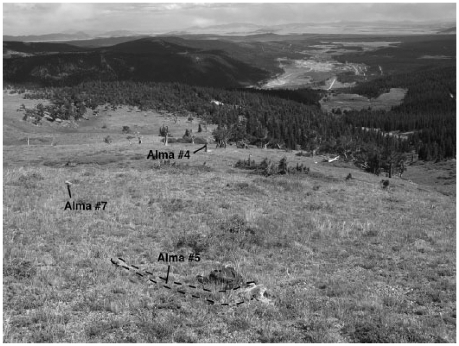
Photograph of site near the town of Alma. In the foreground is remnant #5 (the highest remnant), from which an age 2110 ± 30 14C. yr BP was obtained. Farther downslope is remnant #7, from which an age of 1725 ± 35 14C. yr BP was obtained. In the distance is standing remnant #4 from which an age of 2015 ± 30 14C. yr BP was obtained from the pith region. View is looking downslope (south) to the forest line. Distance between remnants #5 and #4 is approximately 125 m.

Photograph of remnant #5 at the Alma site that is partially buried in the hillside by soil creep. Remnant is approximately 2.5 m in length and 40 cm in diameter.
Scattered among the remnants and extending up to an elevation of 3679 m are multi-stemmed bristlecone pine saplings 0.5–2 m tall. These trees are commonly windswept on their western side (Figure 4), and branches on this side contain many brown needles.
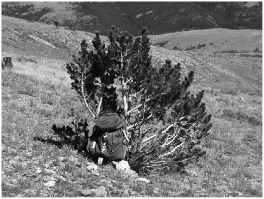
Photograph of young multi-stemmed bristlecone pine sapling at the Alma site growing at an elevation of 3679 m, several meters above the highest remnant.
The initial inspection of the remnants at the Alma site revealed that a standing remnant (Alma #4; Figure 2), approximately 3.5 m in height and 65 cm in diameter at an elevation of 3648 m, contained a small protrusion about 1.3 m above the ground on the eroded, western side that included the pith. An increment core was taken through this protrusion, and a small section containing the pith was submitted for AMS radiocarbon dating. The sample yielded an age of 2015 ± 30 14C yr BP (2043–1890 cal. yr BP) (Table 1). This radiocarbon age suggested other remnants at this site might also provide evidence of a higher-than-present local treeline extending back a couple of thousand years. Throughout this report, radiocarbon ages are given as 14C yr BP and calibrated ages as cal. yr BP.
Radiocarbon ages (14C yr BP), calibrated yr (cal. yr BP), of bristlecone pine remnants sampled in this study.
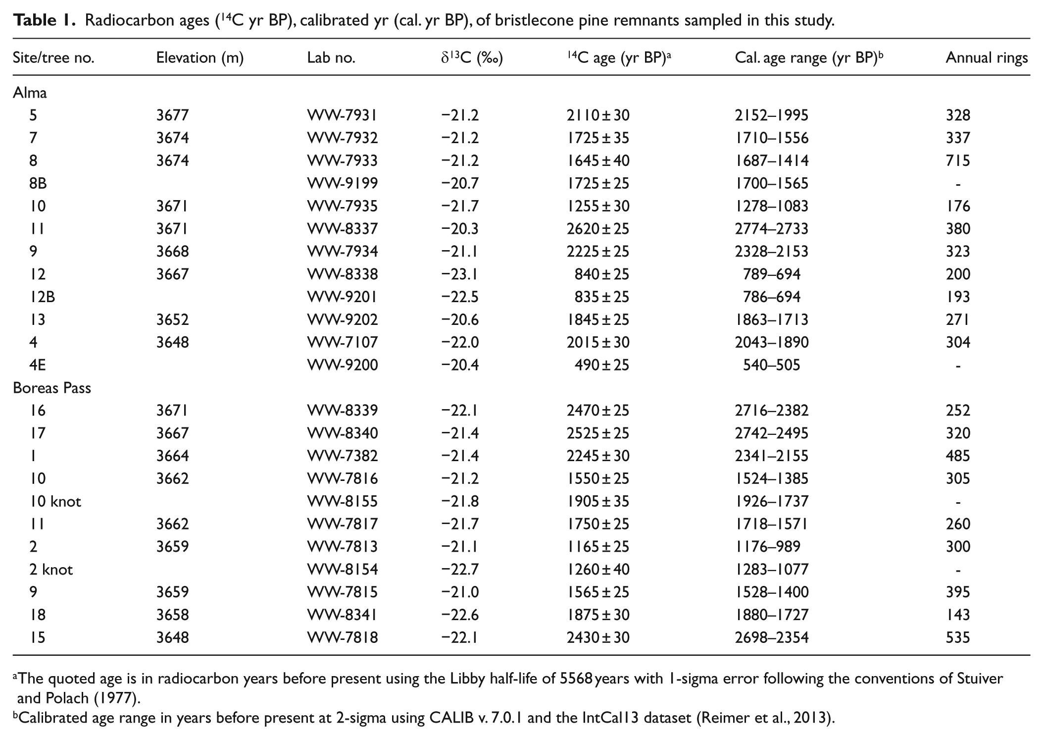
The quoted age is in radiocarbon years before present using the Libby half-life of 5568 years with 1-sigma error following the conventions of Stuiver and Polach (1977).
Calibrated age range in years before present at 2-sigma using CALIB v. 7.0.1 and the IntCal13 dataset (Reimer et al., 2013).
Boreas Pass site
At a site about 2 km southeast of the Continental Divide in the Boreas Pass area of the Colorado Front Range (Figure 1), bristlecone pine remnants again consisting primarily of logs, ranging from about 2–4.5 m in length, lying on the ground (Figure 5) were found at elevations between 3658 and 3671 m. An eroded standing snag, about 3.5 m in height, was found lower on the site at an elevation of 3648 m. Although both bristlecone pines and Engelmann spruce in nearby lower areas were logged for railroad ties in the late 1800s, the study site is beyond and above the limit of the logging as indicated by the lack of stumps that are common in the logged area. The site is on a steep, southwest-facing slope with sparse tundra vegetation. Bedrock at the site consists of a monzonite of Oligocene and Eocene age (Bryant et al., 1981). As is the case with the Alma site, most of the remnants appear to be from single-stem trees that are today growing about 30 m lower in elevation than the highest remnants. The highest live trees are represented by a patch of krummholz Engelmann spruce at an elevation of 3647 m. The highest live single-stem bristlecone pine (treeline) is at an elevation of 3644 m.

Photograph of remnants #1 and #2 at the site near Boreas Pass. Ages of 2245 ± 30 and 1165 ± 25 14C yr BP were obtained from the oldest wood recovered from these remnants, respectively. Remnant #1 is about 4.5 m in length and 46 cm in diameter, while remnant #2 is 3.5 m in length and 36 cm in diameter. Note that both remnants appear to be derived from single-stemmed, fairly large trees and not from krummholz forms.
Scattered on the hillslope below the remnants and extending up to an elevation of 3642 m are multi-stemmed bristlecone pine saplings 1.5–2.5 m tall. These trees are commonly windswept on their western side, and branches on this side contain many brown needles.
During the initial inspection of the Boreas Pass site, an increment core was taken near the base of an eroded log (BP #1; Figure 5), 4.5 m in length and 46 cm in diameter, lying on the ground at an elevation of 3664 m. A 1-cm section of the core containing the oldest remaining annual rings was submitted for AMS radiocarbon dating and yielded an age of 2245 ± 30 14C yr BP (2341–2155 cal. yr BP). As with the Alma site, this initial radiocarbon age suggested other remnants at this site might also provide evidence of a higher-than-present local treeline extending back a couple of thousand years.
At both the Alma and Boreas Pass sites, it was noted that the more weathered and partially buried remnants occur at higher altitudes while the few standing snags are present at lower elevations. Because some of these partially buried remnants (Figures 3 and 6) may have been covered for several hundred years, they were in part decayed.

Photograph of remnant #17 from the Boreas Pass site from which an age of 2525 ± 25 14C. yr BP was obtained. The remnant is one of the highest recovered at the site; note that it is almost completely buried in the hillside by soil creep. Remnant is approximately 2.5 m in length and 30 cm in diameter.
Fire is not thought to be responsible for the occurrence of these bristlecone pine remnants above present-day treeline. Because of the low density of these trees near treeline and the lack of a substantial ground cover between trees on these south-facing slopes, the probability of a widespread fire is minimal. In addition, similar sites with bristlecone pine remnants lying on the ground above the local treeline appear to be of widespread occurrence in the area. Hence, these remnants indicate a higher-than-present treeline in the past and subsequent treeline retreat.
Methods
The sites were revisited in 2009, 2010, and 2012, and an additional 11 samples were taken from eight remnants at the site near Alma and 10 samples from eight remnants at the Boreas Pass site. Elevations of the sampled remnants were taken with a handheld GPS unit at the base of the tree trunk several times during the various visits and compared with a site of known elevation. Samples consisted of multiple cores, collected with either a 30- or 40-cm increment corer or cross-sections collected with a small handsaw. A small fragment from each sample, containing between 10 and 25 of the innermost remaining annual rings, was submitted for radiocarbon dating. Cores and cross-sections were then dried, sanded to a fine finish (600 grit), and polished with steel wool after which they were then examined under a binocular microscope and their annual rings counted (Table 1).
Samples for radiocarbon dating were submitted to the U.S. Geological Survey’s radiocarbon laboratory in Reston, VA, for processing. There the samples were subjected to the standard acid–base–acid (ABA) treatment and combusted under vacuum in the presence of CuO and Ag. The resulting CO2 was split into two aliquots. One aliquot was converted to graphite using an iron catalyst and the hydrogen reduction process and submitted to the Center for Accelerator Mass Spectrometry at Lawrence Livermore National Laboratory for AMS 14C analysis. The second aliquot was submitted to the University of California (Davis) Stable Isotope Laboratory for δ13C analysis. The resultant δ13C value was used to correct the measured 14C activity for isotopic fractionation. All 14C ages were calibrated using the IntCal13 dataset in conjunction with CALIB 7.0.1 calibration software (Reimer et al., 2013).
In several instances, multiple samples were collected from the same remnant. In most cases, this was done to attempt to extend the radiocarbon age of the remnant beyond that of the age of the innermost rings previously collected from the increment core or cross-section. For instance, in 2009 a cross-section was collected from remnant #10 at the Boreas Pass site as well as a knot that intruded deeper into the interior of the remnant. The innermost rings from the cross-section, which contained 305 annual rings, yielded an age of 1550 ± 25 14C yr BP while the knot yielded an age of 1905 ± 35 14C yr BP (Table 1). Hence, the age of the knot extended the age of the remnant by up to 415 radiocarbon years (inclusive of 1-sigma errors).
Because remnant Alma #4 was split, a complete core from the pith, on the western eroded side, through the remnant to the outermost wood on the virtually uneroded eastern side could not be taken. A short increment core was taken from the outermost wood remaining on the eastern side of the remnant and an age of 490 ± 25 14C yr BP (540–505 cal. yr BP) was obtained. When combined with the 14C age of the pith (2015 ± 30 14C yr BP, Table 1), the ages indicate that this remnant lived for more than 1500 14C years. However, for all other remnants in this study, a minimum estimate of the period during which the remnant was alive and growing above the present-day treeline (Figures 7 and 8) was determined from the calibrated radiocarbon age of the innermost annual rings recovered from the specimen and the number of annual rings in the core or cross-section.
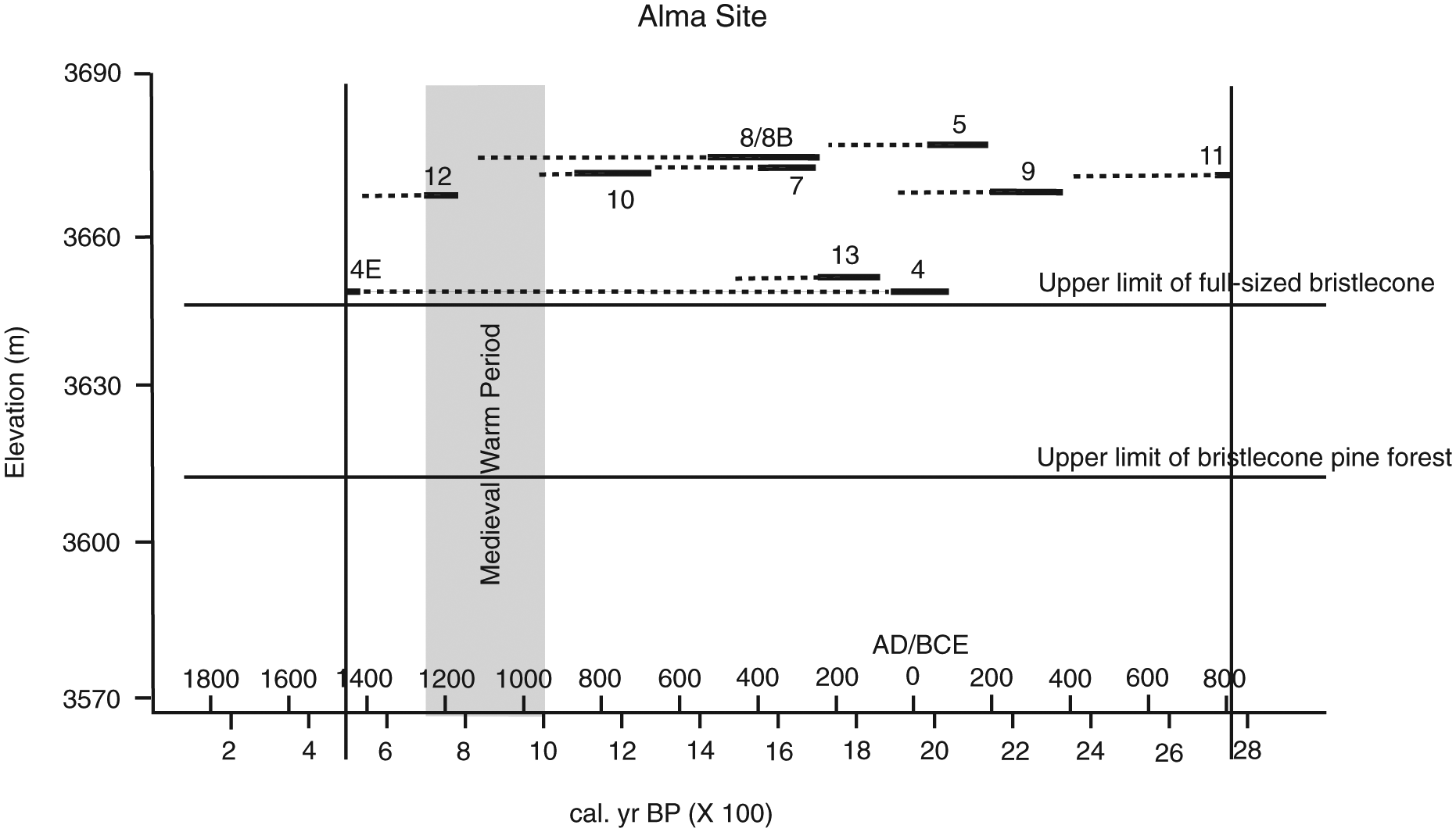
Diagram of calibrated years before present (cal. yr BP) of remnants and elevations at site near Alma. Bars represent the range of calibrated ages obtained from the innermost annual rings recovered from each remnant (see Table 1) except for an age of 505–540 cal. yr BP obtained from the outermost (youngest) wood on the eastern side of remnant #4 (sample 4E, Table 1). As can be seen, all but one of the remnants were clearly established prior to 1200 cal. yr BP. The dashed lines indicate the number of annual rings present in the increment core or cross-section set to the middle of the bar. Hence, the bars and dashed lines for the remnants give an estimate of the period during which the remnants lived above the present-day treeline (from about 2750 to about 500 cal. yr BP), as indicated by the vertical lines.

Diagram of calibrated years before present (cal. yr BP) of remnants and elevations at site near Boreas Pass. Bars represent the range of calibrated ages obtained from the innermost annual rings recovered from each remnant (see Table 1); a ‘k’ represents a range of calibrated ages obtained from a knot that extended into the tree farther than the innermost wood that was recovered from the same remnant. As can be seen, all but one of the remnants were clearly established prior to 1200 cal. yr BP. The dashed lines indicate the number of annual rings present in the increment core or cross-section set to the middle of the bar. Hence, the bars and the dashed lines for the remnants give an estimate of the period during which the remnants lived above the present-day treeline (from about 2750 to about 750 cal. yr BP), as indicated by the vertical lines.
The saplings, indicating a recent advance of treeline, at both the Alma and Boreas Pass sites could not be sampled with an increment borer without causing a severe injury to the main stem of the sapling because of their small diameters. An estimate of the sapling’s ages was obtained by taking a cross-section from one of their lowest branches. These cross-sections were then dried, sanded to a fine finish, polished with steel wool, and their annual rings counted under a binocular microscope.
Results
At the Alma site, of the nine remnants from which sample material was obtained from the innermost annual rings, radiocarbon ages from eight of the remnants ranged from 2620 ± 25 14C yr BP (2774–2733 cal. yr BP) to 1255 ± 30 14C yr BP (1278–1083 cal. yr BP) (Table 1). Only one remnant (Alma #12) produced radiocarbon ages dating from the ‘Medieval Warm Period’: 840 ± 25 14C yr BP (789–694 cal. yr BP) and 835 ± 25 14C yr BP (786–694 cal. yr BP) (Table 1). At the Boreas Pass site, the radiocarbon ages obtained from the oldest wood that was recovered from the nine remnants ranged from 2525 ± 25 14C yr BP (2742–2495 cal. yr BP) to 1260 ± 40 14C yr BP (1283–1077 cal. yr BP) (Table 1).
Evidence of a recent upward migration of bristlecone pines within the past 50–60 years is indicated by scattered multi-stemmed bristlecone pine saplings at both sites. At the Alma site, saplings, 0.5–2 m tall, extend to elevations up to 3679 m (about 2 m above the highest remnant). These trees are commonly windswept on their western side (Figure 4) with many brown needles. Tree ring counts from a lower branch on the two largest saplings indicate establishment in 1965 and 1992. At the Boreas Pass site, evidence of a recent upward migration of bristlecone pines within the past 50 years is indicated by scattered multi-stemmed bristlecone pine saplings, 1.5–2.5 m tall, at elevations up to 3642 m (about 6 m below the lowest remnant and near present-day treeline). Tree ring counts from a lower branch on three of these saplings indicate that they were established by 1956, 1958, and 1970.
Discussion
As previously stated, the authors originally thought that the bristlecone pine remnants in this study may have been established during the ‘Medieval Warm Period’, about AD 950–1200 (about 1000–700 cal. yr BP) (Grove and Switsur, 1994). Clearly, 18 of the 19 radiocarbon ages obtained from both sites (Table 1) indicate that the remnants were established during a period of favorable climate prior to the ‘Medieval Warm Period’ by several hundred and as much as 1700 years (Figures 7 and 8).
Limitations of present study
This study has several limitations. As previously mentioned, only one remnant (Alma #4) contained the pith, whereas in all the other remnants the pith region had been removed by erosion. Hence, the radiocarbon ages, obtained from the oldest remaining annual rings in each remnant, represent a minimum age of the time of tree establishment. As many of the oldest specimens have been severely eroded, several hundred annual rings may be missing from the inner part of the specimen. Hence, even the remnant (Alma #12; Table 1) that yielded the youngest 14C age may have been established prior to the ‘Medieval Warm Period’. From inspection of Figures 7 and 8, it is estimated that the majority of remnants investigated in this study were established from prior to 2700 cal. yr BP to no later than about 1200 cal. yr BP.
The elevations of the remnants indicate only the minimum elevation of timberline during the lifetime of the trees. The remnants may have been subjected to downslope movement by mass wasting processes and higher, and possibly older, remnants may have completely decayed or have been buried by colluvium from slope processes. Indeed, at both sites, the highest remnants recovered were partially buried by colluvium (Figures 3 and 6), suggesting any remaining higher and/or older remnants, if present, may be completely buried. In addition, Grayson and Millar (2008) suggest that prehistoric people may have removed deadwood from treeline areas for fuel. Later, beginning in the 19th century, hunters, prospectors, and sheepherders may have also removed remnants for firewood. Therefore, the altitude of these remnants only establishes the minimum elevation of treeline during the lifetime of the tree (LaMarche and Mooney, 1967). Finally, evidence of climatic episodes lasting several decades or longer may be lacking because of the response time of treeline to climate change (LaMarche, 1973).
Other evidence for a warm period in the mid to late Holocene in Colorado
Several other studies in the region suggest a warm period during the mid to late Holocene at about the time when the trees in this study were established. In the Mount Evans area of the Colorado Front Range, approximately 40 km northeast of the study sites, Carrara et al. (1992) observed dead standing trees and downed remnants of bristlecone pine up to 40 m above the present timberline. Comparison of the tree-ring record from the dead trees with a master chronology suggested the remnants were present on the site by AD 126 (1824 cal. yr BP) (Carrara et al., 1992). Also in the Mount Evans area, Doerner (2007) concluded, based on pollen analysis, that a forest expansion, including a treeline rise, occurred between about 3000 and 1600 14C yr BP (about 3200 and 1480 cal. yr BP).
Farther north in the Rocky Mountain National Park region, also in the Colorado Front Range, several studies have also found evidence of warmer climate and/or higher treeline during the mid to late Holocene. In the Roaring River Valley, Madole (2012) identified a period of warmer climate from about 2450 cal. yr BP to approximately 1630 cal. yr BP based on the accumulation of fine-grained, wetland sediment containing substantial amounts of organic detritus. Near the head of May Creek, just north of the park, large logs on the margins of a severely melted ice patch are much larger in size than nearby trees. Radiocarbon ages on the outer growth rings from two spruce trunks both yielded ages of 2840 ± 20 14C yr BP (Lee and Benedict, 2012) or about 2900 cal. yr BP. In the Mummy Pass area, evidence of a higher than present-day timberline during the middle Holocene was also found. Here, trunks of full-sized trees (Picea engelmannii) were found emerging from the melting edge of a snowbank in a northeast-facing recess at an elevation of 3475 m, just below the modern tree limit (Benedict et al., 2008). Radiocarbon ages of the outer growth rings of four of these trees ranged between 3860 ± 15 14C yr BP (CURL-8892) and 3780 ± 20 14C yr BP (CURL-8884) and indicated that their date of death was about 4200 calendar years ago (Benedict et al., 2008). The trunks were interpreted as indicating that forest vegetation grew on the present-day tundra during this time and that regional timberline was at least 100–150 m higher than present (Benedict et al., 2008).
Evidence from other areas in Colorado has also suggested a warm period during the mid to late Holocene. In the La Plata Mountains of southwest Colorado, Petersen and Mehringer (1976), based on pollen analysis, identified a rise in timberline at about 2600 cal. yr BP. In central Colorado, Fall (1997) determined that the modern climate was established about 2000 14C yr BP (about 2110–1830 cal. yr BP), although the upper limit of krummholz has fluctuated, reflecting warmer periods since this time. Slightly warmer-than-present conditions persisted until about 1000 14C yr BP (about 965–800 cal. yr BP) when krummholz of Engelmann spruce and subalpine fir no longer grew in Red Well Basin (Fall, 1997).
Evidence for higher-than-present treelines elsewhere in the western United States during the middle to late Holocene
Several papers have compiled evidence of higher-than-present treelines during the past few thousand years in the western United States, consisting of remnant logs lying on the surface or recovered from melting snow banks (Carrara, 2011, Appendix 1; Graumlich et al., 2005, Table 1). These areas include the Glacier National Park region and the Beartooth Plateau of Montana, the Lemhi Range of Idaho, the Yellowstone National Park area of Wyoming, the Sangre de Cristo Mountains and Front Range of Colorado, the Snake Range of Nevada, and the Sequoia National Park area and White Mountains of California.
On Campito and Sheep Mountains in the White Mountains of eastern California and Mount Washington in the Snake Range of east-central Nevada, LaMarche and Mooney (1967) found dead trees and large, fallen remnants of Great Basin bristlecone pine (Pinus longaeva) on slopes above the highest living trees of similar size. Radiocarbon ages were obtained on samples from four remnants from the White Mountain sites and three from the Snake Range site. In addition, the number of annual rings in each sample was determined. Hence, the approximate dates of the earliest and latest annual rings were identified.
Although weathering and decay had destroyed the innermost wood in most of the samples, the date of establishment for the four samples from the White Mountains was estimated by adding the number of likely missing rings based on a projection of the radii of curvature of concentric annual rings (LaMarche and Mooney, 1967). These four samples were estimated to have been established at altitudes 120–150 m above treeline between 5800 and 3100 14C yr BP (LaMarche and Mooney, 1967, Table 1) (about 6730–6490 and 3440–3175 cal. yr BP, respectively). As in the present study, the precise date of establishment of the three remnants from the Snake Range, about 120 m above present treeline, could not be estimated because the remnants were too weathered to determine their original form. However, the radiocarbon ages indicate that they were established sometime prior to 2500 14C yr BP (about 2740–2380 cal. yr BP) (LaMarche and Mooney, 1967).
In an expansion of their original study on Mount Washington in the Snake Range, a total of 14 radiocarbon ages (including the three presented in LaMarche and Mooney, 1967) were obtained from 13 standing dead snags and remnants of bristlecone pine lying on the ground above present-day tree limits (LaMarche and Mooney, 1972). Living bristlecone pines at this site show a progressive gradation from tall, erect trees in the upper forest zone to dwarfed, prostrate krummholz at higher elevations. LaMarche and Mooney (1972) determined that a similar gradation existed from 4000 to at least 2000 14C yr BP (about 4780–4295 to at least 2110–1830 cal. yr BP), but that the boundaries between the tree forms were at least 100 m higher than today. Because an indeterminate amount of wood had been eroded from the original outside and pith parts of many of these remnants, this time span represents a minimum estimate of the time during which the treeline was higher than at present.
A subsequent study on Campito and Sheep Mountains in the White Mountains was reported by LaMarche (1973). Based on radiocarbon ages and cross-dating of bristlecone pine remnants above present-day treeline, he concluded that on Campito Mountain, treeline was 70–110 m above the modern treeline from about 7400 14C yr BP (about 8350–8050 cal. yr BP), the beginning of his record, to about 800 14C yr BP (about 895–660 cal. yr BP) (LaMarche, 1973, Figure 17). On nearby Sheep Mountain, where the oldest remnant dated back to about 5600 14C yr BP (about 6475–6300 cal. yr BP), treeline was determined to be about 50–150 m above the modern limit from 5600 to 800 14C yr BP (LaMarche, 1973, Figure 17). LaMarche (1973) cautioned that his estimates of higher treeline positions should be considered minimum values in that remnants higher than those collected may have existed at one time but may have disintegrated with time.
At Cirque Peak in the southern Sierra Nevada of California, Scuderi (1987) used a combination of radiocarbon ages and cross-dating of foxtail pine (Pinus balfouriana) remnants to determine timberline fluctuations since 6300 14C yr BP. Scuderi (1987) found that timberline descended from a high at 6300 14C yr BP to a low at 900 14C yr BP. Between 6300 14C yr BP (about 7410–7025 cal. yr BP) and 3300 14C yr BP (about 3675–3400 cal. yr BP), timberline was about 70 m higher than the present-day limit. From 3300 to 2400 14C yr BP (about 2700–2340 cal. yr BP), it was about 35 m above the present limit; from 2400 to 1300 14C yr BP (about 1305–1085 cal. yr BP), it was 12 m above the present limit; from 1300 to 900 14C yr BP (about 925–725 cal. yr BP), it was below the present limit; and since 900 14C yr BP, timberline has been at its present limits (Scuderi, 1987).
In the Sequoia National Park area of California, based on dendrochronological analysis of remnant foxtail pines above present-day treeline, Lloyd and Graumlich (1997) determined that treeline was higher than present during most of the last 3500 years. Declines in treeline occurred twice in the last 1000 cal. years: at 950–550 cal. yr BP and at 450–50 cal. yr BP. The first decline occurred during a period of warm temperatures in which at least two multi-decadal droughts occurred; the last decline occurred during a period of low temperatures (Lloyd and Graumlich, 1997) corresponding to the ‘Little Ice Age’.
At Union Peak in the northern Wind River Range of western Wyoming, Morgan et al. (2014) found whitebark pine (Pinus albicaulis) remnants extending above the present-day treeline. Based on radiocarbon dating they concluded that treeline was about 100 m higher than present between 1800 and 800 cal. yr BP and corresponded to a regional increase in effective moisture as opposed to warmer temperatures (Morgan et al., 2014).
In the Greater Yellowstone Area, including the Absaroka and Gallatin Mountains, studies have identified numerous ice patches where the remains of large trees are preserved above modern treeline (Lee et al., 2014). Radiocarbon ages of wood from these remnants range between 7955 ± 15 and 640 ± 15 14C yr BP (Lee et al., 2014) (about 8860–610 cal. yr BP).
The above studies and others (Carrara, 2011, Appendix 1; Graumlich et al., 2005, Table 1) clearly indicate multiple advances and retreats of treeline during the middle to late Holocene.
Recent evidence for a rise in treeline
Evidence of recent upward migration of bristlecone pines is demonstrated at the Alma site by young multi-stemmed bristlecone pine saplings growing at elevations up to 3679 m (about 2 m above the highest remnant) (Figure 4). The tallest of these saplings is about 2 m in height, and branches on the western side are windswept and contain brown needles. On several of these saplings, analyses of annual rings in the lowest branches indicate that they were established by AD 1965 and represent the highest establishment of bristlecone pines in the past 1200 cal. years. Farther west on a dolomite ridge of the Manitou Formation (Widmann et al., 2004), young multi-stemmed bristlecone pine saplings reach an elevation of 3800 m.
LaMarche (1973) found that bristlecone pines (Pinus longaeva) extend about 100 m higher in altitude on dolomite and limestone bedrock areas than in areas underlain by sandstone and shale. Similarly, in the area of the Alma site, the young colonizing bristlecone pines are able to reach an altitude approximately 120 m higher on the dolomite substrate than on the quartz monzonite porphyry underlying the remnants investigated in this study.
At the site near Boreas Pass, young bristlecone pine saplings have not reached the elevation of the highest remnants. The highest observed sapling was found at an elevation of about 3642 m (about 6 m lower than the lowest remnant sampled). This multi-stemmed tree was about 1.2 m in height, and branches on the western side are windswept and contain brown needles. Analyses of annual rings on one of the lowest branches indicate that the tree was established by AD 1965. In addition, analyses of annual rings from the lowest branches of three single-stem bristlecone pine saplings, 1.5–2.5 m in height, at an elevation of 3627 m (about 21 m lower than the lowest remnant) indicate that they were established between AD 1956 and 1970.
Other studies in Colorado also indicate a recent advance of treeline. In the Mount Evans area of the Colorado Front Range, Carrara et al. (1992) observed bristlecone pine saplings growing among dead standing trees and downed remnants of an older forest up to 40 m above the present timberline. Age estimates of these saplings, based on several cores, suggested that their establishment began in the 1940s. Carrara et al. (1992) concluded that these saplings are encroaching on high-elevation sites that have not been colonized by bristlecones for 1800 years.
In the La Plata Mountains of southwestern Colorado, Petersen (1994) documented a treeline rise of about 50 m in the past 100 years, based on repeat photography. In the Sawatch Range of central Colorado, Fall (1997) noted the expansion of krummholz conifers in Red Lady basin during the past 100 years and thought they demonstrated the response of these high-elevation conifers to warmer temperatures. In the Sangre de Cristo Mountains and the Colorado Front Range, Elliott and Kipfmueller (2010) noted young trees colonizing the areas above timberline with predominantly younger trees occupying the highest elevations. They found that 93% of these young trees were established since 1950 and 64% since 1970 (Elliott, 2012; Elliott and Kipfmueller, 2010), corresponding to a rise in cool-season minimum and spring minimum temperatures (Elliott, 2012).
Farther north in the Wind River Range of Wyoming, Morgan et al. (2014) noted that young, non-krummholz whitebark pines are reestablishing in areas that were, until recently, in the alpine zone. Morgan et al. (2014) estimated that most of these trees appear to be no more than 20 years old.
In the White Mountains of California, LaMarche (1973) noted that ‘a large number of bristlecone pines have become established in the upper treeline area since about 1850 A.D., with a preponderance of those in the Sheep Mountain area having been established since 1940’ (p. 653). At three sites near treeline, also in the White Mountains, Salzer et al. (2009) found that bristlecone pine tree-ring growth in the second half of the 20th century was greater than during any other 50-year period in the last 3700 years. Salzer et al. (2009) concluded that increasing temperatures at these treeline sites are the likely cause of the unprecedented growth rate. These increasing temperatures in the treeline area probably account for the observation of LaMarche of recent establishment of bristlecone pine at treeline sites.
Conclusion
A total of 23 radiocarbon ages were obtained from the innermost remaining annual rings of 18 bristlecone pine (Pinus aristata) remnants above the present-day treeline at two sites near the Continental Divide in central Colorado. The radiocarbon ages combined with the annual ring counts from these remnants define a period of treeline as much as 30 m above the present-day limit. The oldest trees at each site yielded radiocarbon ages of about 2700 cal. yr BP, indicating establishment prior to this time. In general, the majority of the remnants were established from at least 2700 cal. yr BP to no later than about 1200 cal. yr BP and predate the ‘Medieval Warm Period’ by several hundred to as much as 1700 years. The remnants grew above the present-day limit of bristlecone pine from sometime before 2700 to about 800 cal. yr BP.
Because the remnants were subjected to severe erosion such that the pith was missing in all but one sample, the radiocarbon ages determined for the oldest remaining annual rings in the remnants represent a minimum date of tree establishment.
Inspection of the area above the highest remnants at both sites failed to reveal any additional remnants. Any higher remnants, if they were initially present, may have been completely decayed, buried by slope processes, or simply removed for firewood. Hence, the altitude of the highest remnants in this study, 30 m above the present treeline, may represent a minimum elevation of treeline during the last 2700 cal. yr BP.
Evidence of even more recent climatic warming is demonstrated by the establishment of bristlecone pine saplings at both sites. At the Alma site, several young multi-stemmed bristlecone pine saplings are growing above the highest remnants. The saplings were established by AD 1965 and generally indicate the highest establishment of bristlecone pines in the last 1200 cal. yr BP. At the Boreas Pass site, bristlecone pine saplings are now colonizing areas above the present-day treeline and are approaching the elevation of the lowest remnants. These saplings indicate establishment between AD 1956 and 1970.
Footnotes
Acknowledgements
The authors thank DR Muhs and RS Thompson (USGS, Denver) and two anonymous reviewers for their thorough and valuable comments of earlier drafts of this manuscript.
Funding
The research reported here was supported by the U.S. Geological Survey’s Climate and Land Use Change Research and Development Program.