




Abstract
Coastal barriers account for approximately one-eighth of the world’s coastline. Barriers are the most common landform type in the southern part of the Baltic Sea area. Despite the long history of research, the issue of barrier coast evolution remains unresolved. The topic of this research is to determine the conditions under which the barrier coast evolved in the Holocene and to explain the local, different histories of its development. A 35 km long stretch of the coastal zone in the eastern Pomeranian Bay (southern Baltic) was explored using boreholes, seismoacoustic and GPR profiling, as well as radiocarbon and OSL dating, biostratigraphic studies and lithological analysis. Three main groups of deposits were identified: barrier subsoil deposits, barrier deposits (marine and aeolian sand, as well as interdune peat) and Rega River delta deposits. In the early Northgrippian (~8000 yr b2k), the coastline was located from about 2 to 12 km north of its present position. In the period 8000–6000 yr b2k, the coastline migrated southwards (landwards), initially at a rate of up to 22 m/yr and later up to 2 m/yr. The main driving forces at that time were climate warming and rapid sea level rise. When the Holocene transgression ceased, there were three different histories of the barrier coast development in the study area: a barrier that was still transgressive, a barrier that evolved from transgressive to progradational, and a barrier that evolved from transgressive trough progradational to transgressive again. The main determinants of these different histories were the lithology and relief of the barrier subsoil (accommodation space) and the time-varying amount of sand available for barrier formation, which varied in different parts of the study area.
Keywords
Introduction
Coastal barriers account for approximately one-eighth of the world’s coastline. A large part of today’s barrier coasts was formed after the end of the Last Glacial Maximum (Roy et al., 1994). Some barriers were formed as a result of longshore growth of spits. Others are the result of the emergence of an offshore bar during sea level lowering or the partial submergence of a pre-existing coastal sand ridge during sea level rise. Some result from the movement of sand and gravel towards the shore during the Holocene marine transgression (Bird, 2003). They provide a valuable service by reducing storm surge penetration and wave impact on the mainland (Mariotti, 2021).
Many years of research have led to the accumulation of extensive knowledge about barrier formation and the factors driving their evolution in many regions of the world, including the coasts of marginal seas (McBride et al., 2013, 2022). The evolution of coastal barriers is controlled by several factors: climate variability, sea level oscillations, barrier subsoil characteristics, sediment budget and waves (Hesp and Short, 1999). The interaction between these factors results in different types of barriers: progradational (regressive), aggradational (stationary) and retrogradational (transgressive) (Flemming, 2002; Rosa et al., 2017; Roy et al., 1994). Nevertheless, most of researches has applied mainly to high-energy ocean coasts and tidal seas. Despite numbers of research on geology and development of the barriers (e.g. Barboza et al., 2018, 2021; Fruergaard et al., 2021; Peterson et al., 2020) many questions about interactions between local geological settings and driving forces still need to be answered. Especially, information concerning barrier coast of relatively small, intracontinental, tidalless seas are rare.
Barriers are the most common landform type in the southern part the Baltic Sea area, from the Danish coast to the Latvian coast. They have been the subject of research since the early 20th century (e.g. Keilhack, 1914; Klautsch, 1917; Sonntag, 1915; von Bülow, 1929; von Wichdorff, 1919). Research into the southern Baltic barriers was intensified in the late 20th century and early 21st century (e.g. Badyukova et al., 2019; Hoffmann et al., 2005; Lampe and Lampe, 2021; Miotk and Bogaczewicz-Adamczak, 1987; Prusinkiewicz and Noryśkiewicz, 1966; Tobolski, 1980; Tomczak, 1995; Tomczak et al., 1989). The most valuable, although few on the southern Baltic coast, are chronological studies of barrier development (e.g. Kalińska-Nartiša et al., 2017; Reimann et al., 2010, 2011; Uścinowicz et al., 2021). However, so far the vast majority of the studies cited above have never been integrated with seabed data and jointly interpreted. As a result, despite the long history of research, the issue of the southern Baltic barrier coast evolution remains unresolved.
The objective of this study is to present a better insight into the origin and development of the southern Baltic barriers by integrating the results of past and recent research characterising the geological structure of the coastal zone. Specifically, this work aims to identify the main driving forces and determinants governing the development of barriers in the selected part of the southern Baltic coast, where morphological and geological features indicate different evolutionary histories of adjacent barrier sections. The specific issues addressed in this study are as follows: the barrier’s respond to changes in the rate of sea level rise, the impact of palaeorelief (accommodation space) and subsoil lithology on the barrier’s evolution as well as barrier’s respond to a changing sand budget (sediment supply).
Finally, we attempted to identify the interactions between the above-mentioned factors generating different evolutionary histories and to present development models for different types of barrier coasts.
Study area
The study area is located in the north-western part of Poland along the south-western coast of the Baltic Sea, in the eastern part of the Pomeranian Bay coast (Figure 1). The Pomeranian Bay is a shallow body of water with a maximum depth of ca. 21 m in its northern part, close to the seabed elevation of Odra Bank. In the south, the Pomeranian Bay is bounded by the German coast of the islands of Rügen and Usedom to the west and by the Polish Pomeranian coast to the east. The coast is characterised by alternating cliff and barrier sections. Except the Rügen cliffs, where Cretaceous chalk outcrops occur, the cliffs are built of Pleistocene till and glaciofluvial sand and gravel. The highest cliffs are on the islands of Rügen and Wolin with a maximum height of approximately 118 and 93 m, respectively. Barriers are slightly more common than cliffs, especially in the Polish part of the coast. Coastal lowlands and locally lagoons are found landwards, behind the dunes.
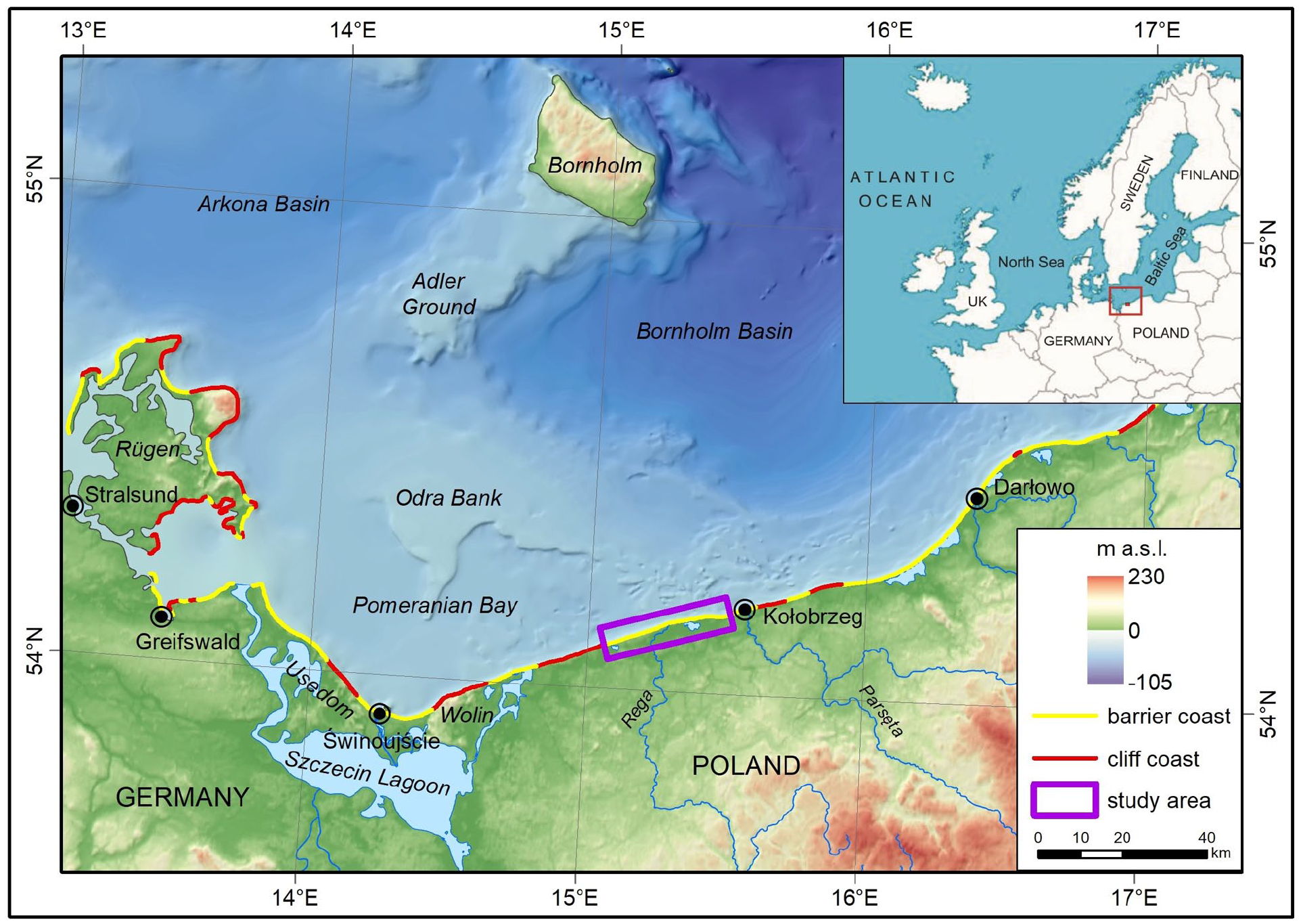
Location of the study area. Source of bathymetry: Polish Geological Institute – National Research Institute, source of DEM (land) – Copernicus Land Monitoring Service (n.d.)
The study area covers a 35 km stretch of the barrier coast west of Kołobrzeg (Figure 1). The dunes are generally not higher than 5–12 m, only locally, behind the foredune, barchanoid dunes with a maximum height of up to 36 m occur (Musielak et al., 2005; Sydor et al., 2011). The average width of the beach is ca. 55 m in the western part of the study area and ca. 45 m in the eastern part with seasonal variations of about 20–30 m (Musielak et al., 2005). The width of the shoreface ranges from 500 to 1300 m and its base is marked by a change in the gradient at a depth of ca. 7–10 m b.s.l. In the upper part of the shoreface, up to a depth of ca. 5–6 m, there are 2–3 sandbars with a relative height of ~1.0–2.0 m (Kramarska et al., 2016; Uścinowicz, 1985). In the study area there are three shallow (depth up to 2.5 m) coastal lakes: Resko Przymorskie Lake, Liwia Łuża Lake and Korzarzewo Lake. Two of them (Resko Przymorskie Lake and Liwia Łuża Lake) are genetically lagoons but we use term “lake” according to Polish geographical name (Appendix 1).
The study area is located entirely on the West European Palaeozoic Platform close to its eastern boundary – the Teisseyre-Tornquist Zone (Figure 2). The pre-Quaternary bedrock within Pomeranian Bay, the Szczecin Lagoon and its coasts is represented by Mesozoic rocks, mainly Cretaceous, but locally also by Jurassic and Triassic deposits with a system of faults (Dadlez et al., 2000; Kramarska, 1999).
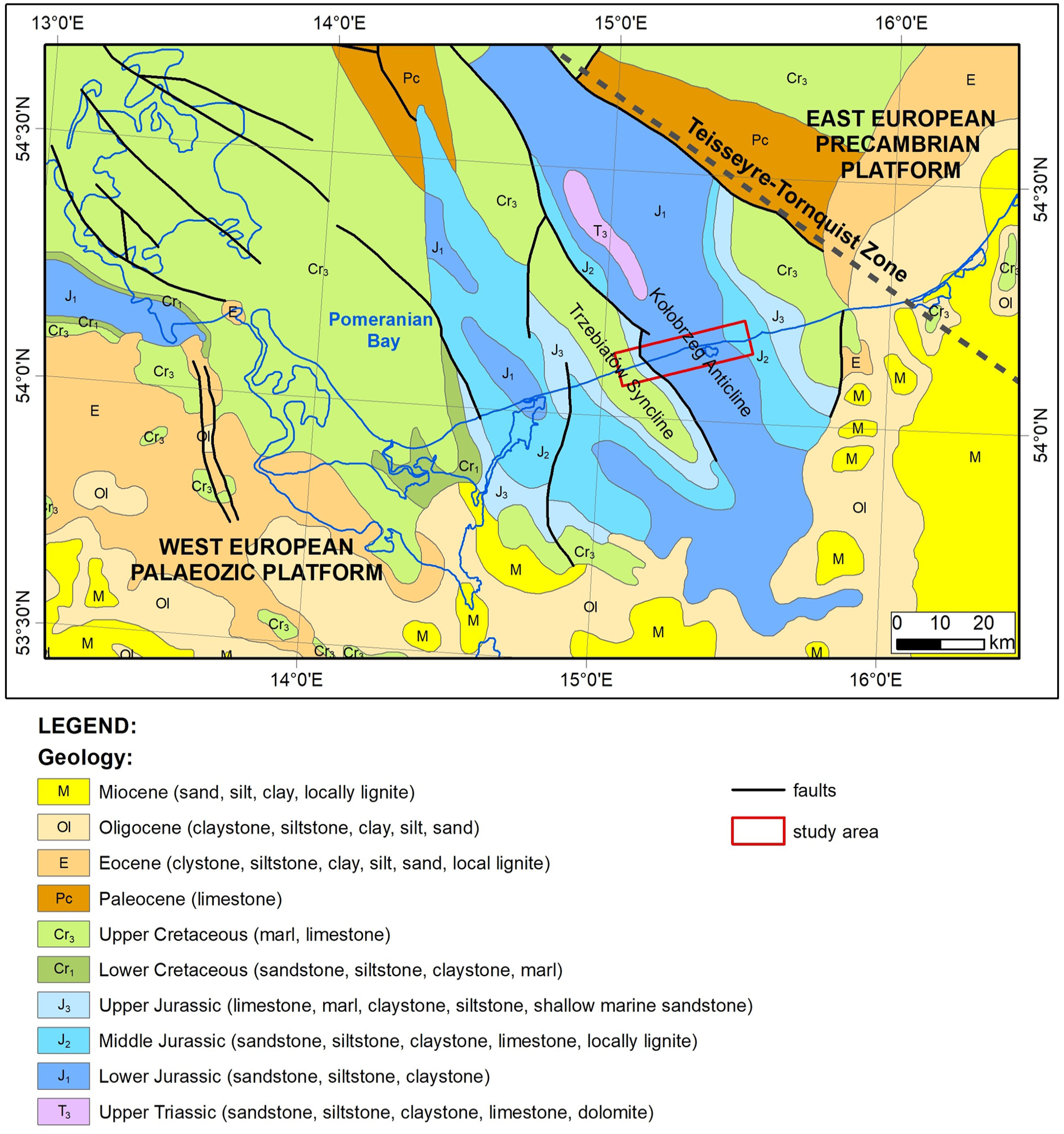
Simplified geological map without Quaternary deposits (acc. to Kramarska, 1999; Sigmond, 2002).
Mesozoic rocks are covered by Pleistocene glacial and glaciofluvial deposits of varying thicknesses ranging from a few to ca. 150 m. Glacial deposits are represented by tills of different glaciations, from the Sanian (Elsterian) to the Vistulian (Weichselian). Glaciofluvial sand and gravel are less common. Late Pleistocene and Holocene deposits consist of two units – the lower one of terrestrial origin (fluvial sand and silt, lacustrine gyttja and peat) and the upper one represented by Middle and Late-Holocene sediments of marine, lagoonal and aeolian origin (Butrymowicz and Niewitecka, 1974; Dobracka, 1984, 1988, 1990, 1992, 2020, 2021; Dobracki, 2009, 2015; Uścinowicz, 1989).
Erosion and accumulation in the Pleistocene led to a diversity of morphological and geological features in the study area. During the glacial periods, glacial and glaciofluvial accumulation dominated, both within the present-day inland and shallow offshore areas. During the interglacials, including the Holocene, marine erosion affected the present-day offshore areas, whereas various terrestrial sediments were deposited in the inland part. Therefore, the variation in surface morphology, as well as in the thickness and lithology of Quaternary sediments is greater in the inland part of the study area.
Although the available literature does not provide a precise definition of the offshore and inland boundary of the barrier, the morphological and lithological features described above allow us to define the range of the barrier. The foot of the shoreface (subaqueous coastal slope sensu Zenkovich, 1967) marked by a change in shoreface gradient is considered as the offshore limit of the barrier, whereas the range of marine and aeolian sands is considered to be the barrier limit on the landward side. In the central part of the study area, the marine and aeolian sands are covered by peat. At the northern shores of Resko Przymorskie Lake, they are below the water table (Figure 3).

Quaternary deposits in the study area and its vicinity (inland simplification based on Dobracka, 1984, 1988, 1990, 1992, 2020, 2021; Dobracki, 2009, 2015; offshore acc. to Uścinowicz, 1989). Source of bathymetry: Polish Geological Institute – National Research Institute.
The Late Pleistocene and Holocene history of Western Pomerania and the Pomeranian Bay began with the retreat of the ice sheet around 16,000 years ago (Andrén et al., 2011; Houmark-Nielsen and Henrik Kjaer, 2003; Tylmann and Uścinowicz, 2022; Uścinowicz, 2014). The history of the Pomeranian Bay, like the entire Baltic Sea area, is governed by isostasy, eustasy and the resulting connections and disconnections with the North Sea during the Late Pleistocene and the early Holocene (Björck, 1995). Therefore, the evolution of the Baltic Sea is marked by freshwater and brackish phases, resulting in five stages: the Baltic Ice Lake, the Yoldia Sea, the Ancylus Lake, the Littorina Sea and the Postlittorina Sea (e.g. Andrén et al., 2011; Rosentau et al., 2017; Uścinowicz, 2014).
The glacio-isostatic uplift in the southern Baltic area began around 18,500 years ago and stopped about 10,500–10,000 years ago. The total uplift of the area in this period was ca. 120 m. A glacio-isostatic forebulge migrated through the southern Baltic between approximately 10,000 and 9000 years ago, and slight subsidence occurred between 9000 and 4000 years ago. The last 4000 years have been a period of equilibrium of the Earth’s crust (Uścinowicz, 2003).
Data on recent vertical movements of the Earth’s surface in the study area based on precise levelling (Kowalczyk, 2006; Wyrzykowski, 1985) or general principles of geotectonics (Liszkowski, 1982) are inconclusive indicating on subsidence or slight uplift. One of the newer land uplift model for the Baltic region (Vestøl et al., 2019) show a Polish southern Baltic coast as relative stable with a vertical movements close to zero. More detailed, regional assessment using ASG-EUPOS data, Kontny and Bogusz (2012) showed an uplift at a rate of 1.0–1.5 mm/yr, increasing in the study area from west to east.
During the late Pleistocene and early Holocene, the water level in the southern Baltic changed relatively rapidly – from a depth of ca. 55 to 25 m below the current level. About 9500 yr b2k, the Littorina transgression started from a level of about –28 m (Uścinowicz, 2003; Uścinowicz, 2006). The water level in the Pomeranian Bay 9000 yr b2k was about 21–20 m lower than at present, ca. 8000 yr b2k was about 12–11 m lower and ca. 7000 yr b2k was about 6–5 m lower than today. The rapid rise in sea level, that was up to 9 mm/yr, slowed down between 7000 and 5000 yr b2 k to about 2–1 mm/yr and thereafter slowly approached the current sea level with an average rate about 0.5 mm/yr (Sydor and Uścinowicz, 2022).
The Pomeranian Bay, like the entire Baltic Sea, is a non-tidal, storm-dominated, brackish body of water. Tides in the area do not reach 0.04 m (Łomniewski et al., 1975), but during the migration of low air pressure systems and heavy storm surges, sea level can reach ca. 1.5–2.0 m above mean sea level. Historically recorded maxima are 1.96 m above mean sea level for Świnoujście and 2.16 m for Kołobrzeg (Wiśniewski et al., 2011; Wolski et al., 2014).
Materials and methods
The geological structure of Holocene deposits in the study area was described and discussed in several studies (Cedro, 2016; Cierpicka, 1964; Dobracka, 1984, 1988, 1990, 1992, 2020, 2021; Dobracki, 2009, 2015; Dobracki and Zachowicz, 2007; Dymitriadis, 1974; Gumińska and Chochłowski, 1972; Gumińska and Drużba, 1969; Głuszkiewicz, 1974; Kołodziej, 1980; Krzymińska, 1996; Masłowska et al., 2003; Okonek, 1974; Okonek and Skała, 1977; Schoeneich, 1961; Sydor and Kotrys, 2013; Sydor et al., 2015; Tarnawski, 1978; Wiśniewski and Bielacki, 1984; Witkowska, 1964; Witkowska and Imach, 1968a, 1968b; Witkowski, 1997; Żuk et al., 2017). Data derived from the above-mentioned studies consist of geological profiles from 198 boreholes and results of laboratory analyses (diatoms, molluscs and ostracods, pollen, grain size, radiocarbon dating) from 43 cores, as well as 2D and pseudo-3D GPR data (Figure 4).

Morphology of the study area, location of the boreholes and geological cross-sections. Source of bathymetry: Polish Geological Institute – National Research Institute, source of DEM – IT system for the Country’s Protection Against Extreme Hazards (ISOK, n.d.)
These data were supplemented with data from our own work, including drillings, 2D GPR profiles, grain size analysis, optically stimulated luminescence (OSL) and radiocarbon dating.
All details of the published and archival studies, as well as the newly collected data are presented in Supplemental Appendix 1, available online.
Forty-four core drillings were carried out using a Geoprobe 540 MT Drill Rig and an Eijkelkamp hand auger. The depth of drillings performed with the Geoprobe 540 MT Drill Rig ranged from 2.0 to 15.6 m, and those with the Eijkelkamp hand auger ranged from 1.5 to 8.0 m.
Data for GPR profiles were collected using RAMAC GPR by MÅLA with shielded 250 MHz antennae. A total of 7.1 km of 2D profiles were acquired. All data were analysed using Seismic Unix software. Collected data allow to determine the lithological boundary of barrier subsoil and it was presented on geological cross-sections.
Grain size analysis was performed for 761 samples of sandy deposits. Samples were sieved on a Fritsch™ Analysette 3 PRO Vibratory Sieve Shaker. The mesh interval of the sieves was 0.25 φ. Basic grain-size classes were determined according to Wentworth (1922). Folk and Ward (1957) textural parameters (Mz, σI, SkI, KG) were calculated for each sample using GRADISTAT software (Blott and Pye, 2001).
Optically Stimulated Luminescence (OSL) dating was performed for 13 samples of aeolian sand collected from trench made in the lower part of dune windward slope. Saturation, equivalent dose, cosmic dose, activity concentration of 232Th, 238U and 40K were measured in each sample (Table 1). The analysis was performed by the LumiDatis Laboratory in Toruń.
Results of OSL dating.
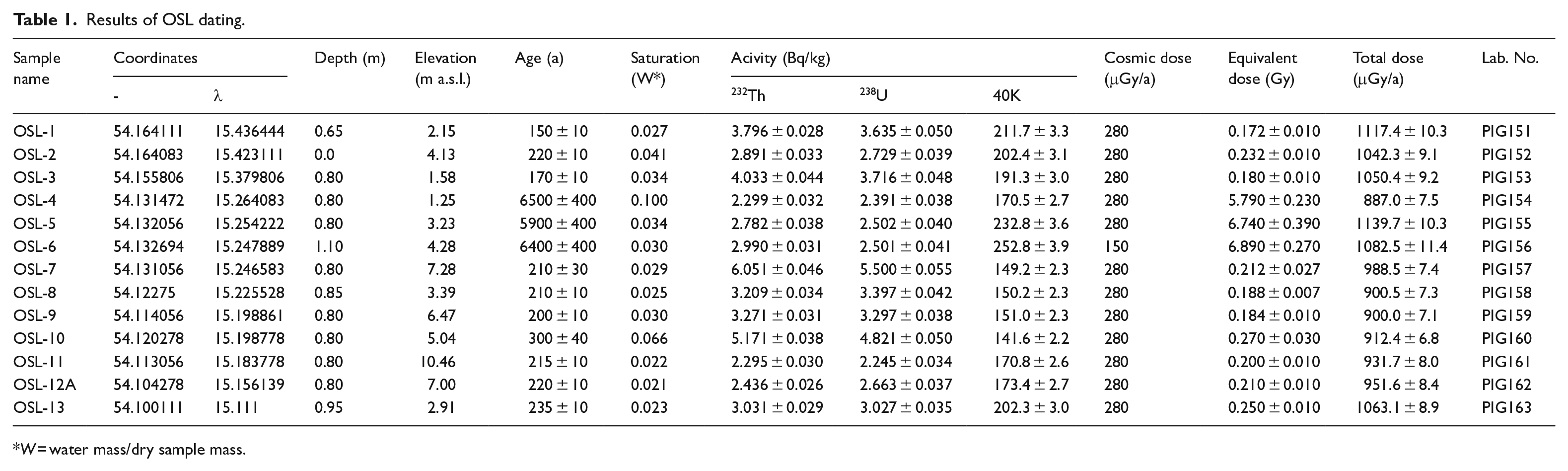
W = water mass/dry sample mass.
All radiocarbon dates used in this study (own and historical data) and methodology of their calibration were presented in a separate research paper (see Sydor and Uścinowicz, 2022).
Results
Geological structure of the barrier and its subsoil
The analysis of the collected data allowed us to determine the lithology and morphology of the barrier subsoil as well as to determine the thickness and extent of the barrier deposits. Towards the sea, the barrier extends to the base of the shoreface. Its distance from the modern shoreline varies from 500 m in the village of Niechorze to 1300 m near the village of Mrzeżyno. In the inland part, the range of the barrier, defined by the presence of marine and aeolian sand, ranges from 100 m in Kołobrzeg to 2000 m in Niechorze.
Three main groups of deposits were identified in the study area: deposits of the barrier subsoil, barrier deposits and Rega River delta deposits.
Barrier subsoil
In the marine part of the study area, the barrier subsoil (palaeodepositional surface) occurs at a depth ranging from 11 m b.s.l. at the shoreface to 2 m b.s.l. in the area of Niechorze and Dźwirzyno. In the inland part, the barrier subsoil occurs at an elevation ranging from 5 m b.s.l. near Mrzeżyno to 5 m a.s.l. south-east of Niechorze (Figure 5a). Pleistocene and Holocene deposits were identified in the barrier subsoil (Figure 5b).
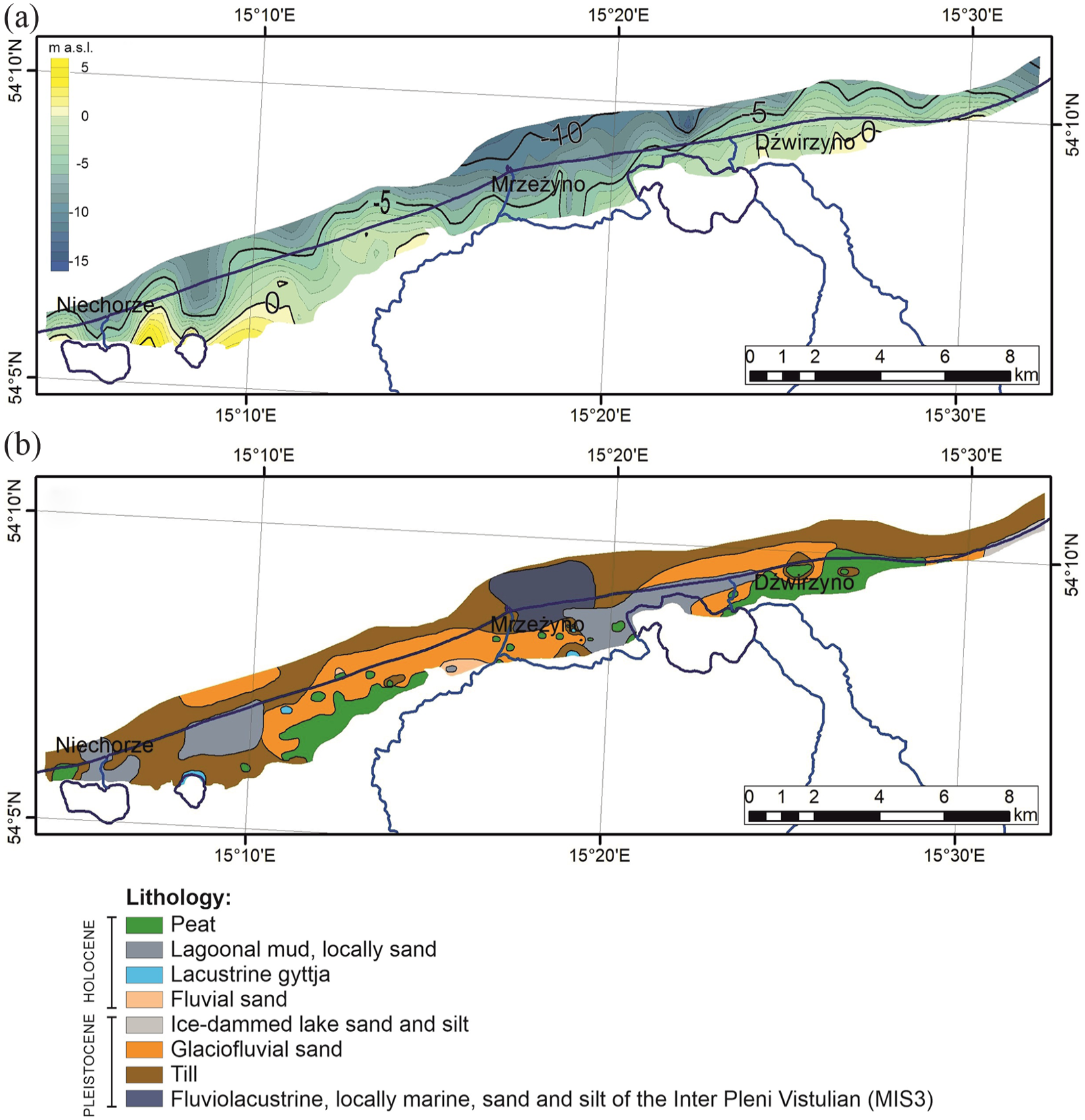
Elevation (m a.s.l.) (a) and lithology (b) of the barrier subsoil.
Pleistocene deposits are represented by fluviolacustrine, locally marine deposits of the Inter Pleni Vistulian (MIS3) and glacial, glaciofluvial and ice-dammed lake deposits of the Vistulian (Weichselian) Glaciation. The Holocene is represented by fluvial, lacustrine and lagoonal deposits and peat.
Fluviolacustrine, locally marine deposits of the Inter Pleni Vistulian (MIS3) were identified in the Mrzeżyno area. This series is composed of silt with fragments of shells and freshwater ostracods (Krzymińska, 1996) and sand with shells of the marine taxon Cerastoderma glaucum (Bruguière) (Krzymińska, 1996).
Glacial deposits in the barrier subsoil occur both at the shoreface and onshore near Niechorze and Mrzeżyno. Acc. to Dobracka (1990, 1992, 2020, 2021) as well as Dobracki and Zachowicz (2007) they are represented by till formed during the Vistulian (Weichselian) Glaciation.
Glaciofluvial deposits occur west and south of Mrzeżyno and in the Dźwirzyno area. Grain size analysis performed for 171 samples from seven cores (boreholes - BH: D1-D3, D5, S6, S7 and S11) revealed that this series is represented by very fine, fine, medium and coarse sand with gravel (Mz 0.00–3.44 φ). The standard deviation value varies between 0.42 and 1.69 φ. The deposits are mainly moderately sorted with small share of other types (poorly and well sorted). The skewness varies from –0.68 to 0.33. Grain-size distribution curves are mainly negatively skewed and nearly symmetrical. Share of other types is small. The range of kurtosis is 0.62–2.80, and it represent mainly leptokurtic and mesokurtic distribution curves with small share of other types. In the relationship between the mean size and standard deviation (Figure 6), a decrease in the mean size value is observed with an increase in the standard deviation value. For the standard deviation–skewness pair, a decrease in standard deviation is observed with an increase in skewness. No clear correlation was found for the last analysed pair (skewness–mean size).

Relationships between Folk and Ward’s (1957) textural parameters for the analysed samples.
A feature that distinguishes glaciofluvial deposits from barrier and aeolian deposits is their poorer sorting. The grain-size textural parameters of the discussed series are similar to those of fluvial deposits. A special feature that distinguishes glaciofluvial deposits from fluvial deposits is a significant admixture of carbonate rocks.
Ice-dammed lake deposits were identified east of Dźwirzyno. Acc. to Dobracka (1984, 1988) the series consists of silty and fine sand, locally with organic matter.
Fluvial deposits in the barrier subsoil occur south-west of Mrzeżyno. Grain size analysis was performed for 97 samples from five cores (BH: D1-D3, M1 and S7). The series is composed of fine and medium sand, locally with gravel (Mz 1.10–3.01 φ) and thin gyttja layers. Standard deviation values are in the range of 0.22–1.81 φ. Deposits are mainly moderately sorted with small share of other types (very well, well and poorly sorted). Skewness ranges from –0.73 to 0.54, and representing mainly nearly symmetrical distribution curves. Share of other types is small. The kurtosis value varies from 0.61 to 4.16 and is typical mainly for leptokurtic distribution curves with small share of other types. In the relationship between the mean size and standard deviation (Figure 6), a decrease in the mean size value is observed with an increase in the standard deviation value. For the standard deviation–skewness pair, a decrease in the standard deviation value was correlated with an increase in the skewness value. For the third pair (skewness–mean size), the correlation is weak, with a decrease in the skewness value accompanied by an increase in the mean size value.
Fragments of freshwater molluscs – Valvata piscinalis (Müller), Pisidium casertanum (Poli), Pisidium casertanum f. ponderosa (Stelfox), Pisidium moitessierianum (Paladilhe), and ostracods – Candona candida (Müller), Candona neglecta (Sars), Cyclocypris ovum (Jurine), Cypridopsis vidua (Müller), Cytherissa lacustris (Sars), Herpetocypris reptans (Baird), Ilyocypris decipiens (Masi), Limnocythere sanctipatricii (Brady and Robertson) were identified in fluvial deposits of core M1.
The main feature that distinguishes fluvial deposits from barrier and aeolian sands is their poorer sorting. Grain-size textural parameters of fluvial deposits are very similar to those of glaciofluvial deposits. A feature that distinguishes fluvial deposits from glaciofluvial deposits is the admixture of organic matter, gyttja layers and sometimes mollusc shells within the sands.
Lacustrine deposits were found south-east of Niechorze, between Niechorze and Mrzeżyno, and east and south-east of Mrzeżyno. The series is composed of gyttja, locally with thin layers of fine sand. Acc. to Krzymińska (1996) in the deposit occurred shells of freshwater molluscs. The radiocarbon age of the upper layer of the lacustrine deposits varies from 8384 yr b2k (BH T15 – Cedro, 2016) to 7283 yr b2k (BH S7).
Lagoonal deposits in the barrier subsoil were identified east of Niechorze and in the vicinity of Mrzeżyno and Dźwirzyno. They are represented by mud, locally with thin sand layers. In the series occurred shells of marine and freshwater molluscs and ostracods (Krzymińska, 1996) as well as diatoms (Cedro, 2016; Krzymińska and Cedro, 2012). The age of the upper part of the series varies from 5172 yr b2k (BH W13) to 3674 yr b2k (BH REWAL 2 – Masłowska et al., 2003).
Basal peat (sensu Lange and Menke, 1967) occurs between Niechorze and Mrzeżyno and in the vicinity of Dźwirzyno. The series is represented by well- and very well-decomposed peat, locally with layers of sand and gyttja. The age of the upper peat varies from 8166 yr b2k (BH T21 – Cedro, 2016) in Mrzeżyno to 508 yr b2k (BH O3) in the area west of Mrzeżyno.
Barrier deposits
Barrier deposits in the study area are represented by Middle and Late-Holocene marine barrier sand, aeolian sand and peat (Figures 7–9, Supplemental Appendix 2, available online).
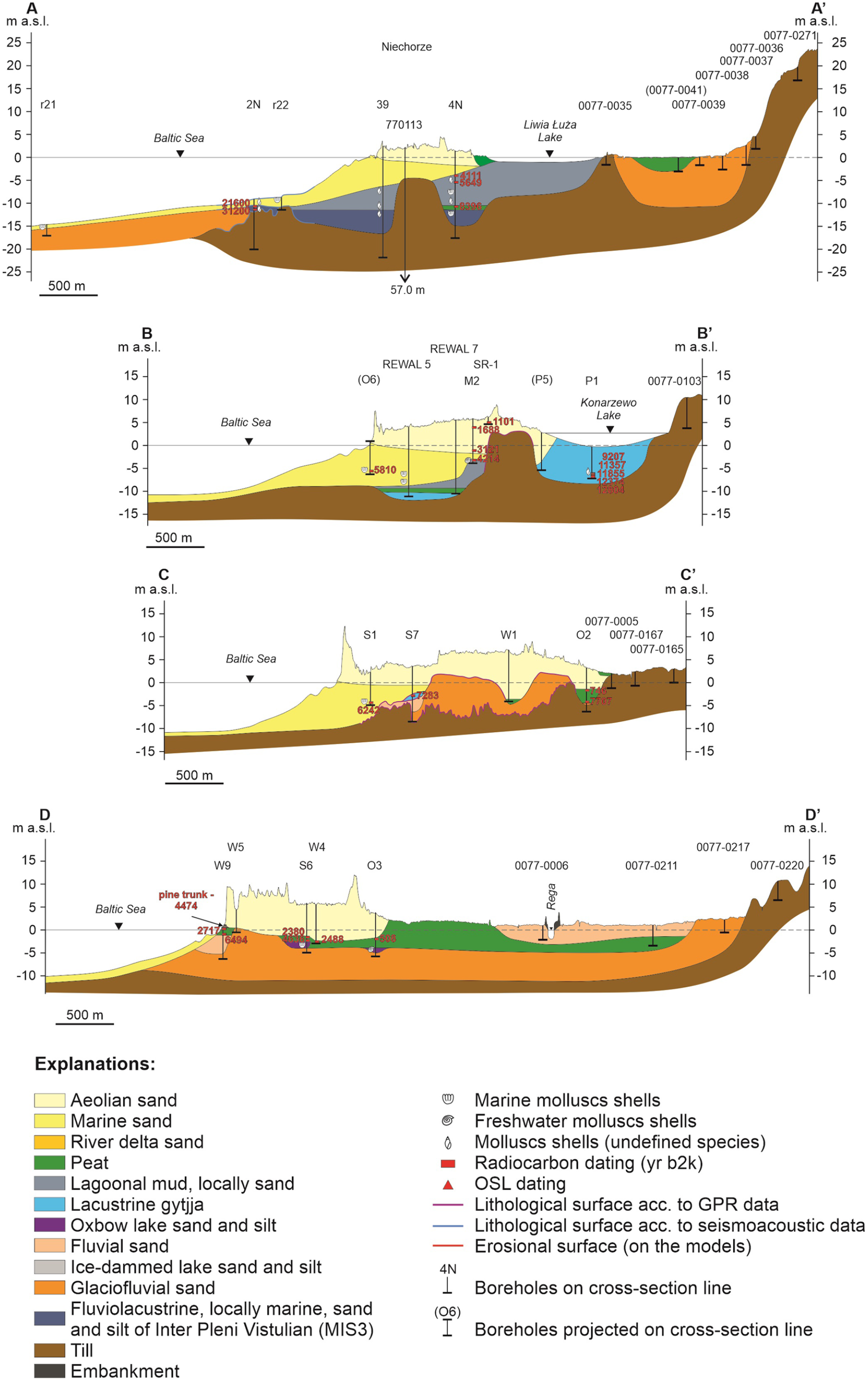
Geological cross-sections A–A′, B–B′, C–C′ and D–D′. See Figure 4 and Supplemental Appendix 1, available online for the location of the cross-sections and core source data.

Geological cross-sections E–E′, F–F′, G–G′ and H–H′. See Figure 4 and Supplemental Appendix 1, available online for the location of the cross-sections and core references. See Figure 7 for explanations.
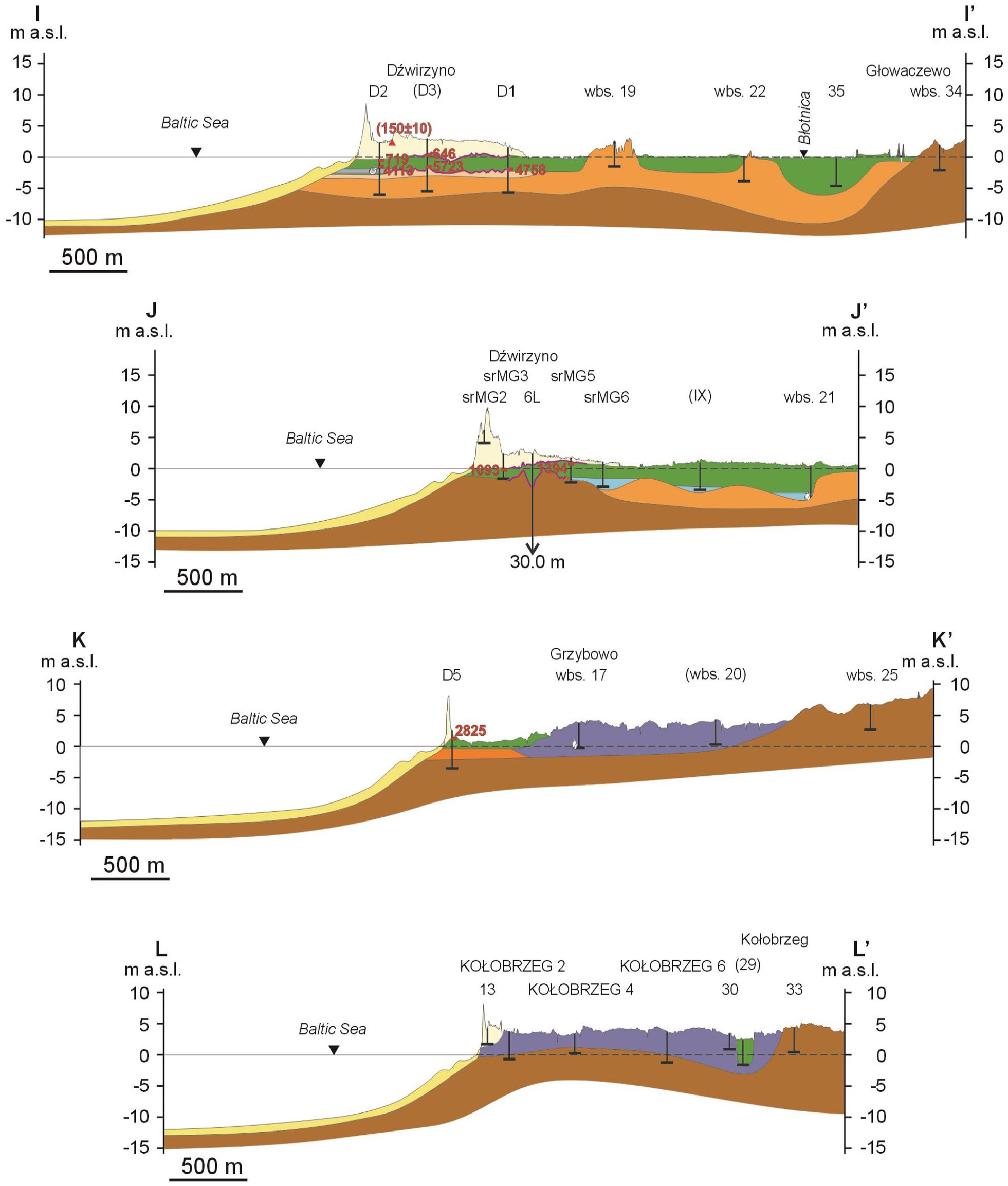
Geological cross-sections I–I′, J–J′, K–K′ and L–L′. See Figure 4 and Supplemental Appendix 1, available online for the location of the cross-sections and core references. See Figure 7 for explanations.
Marine barrier sand
Marine barrier sand occurs from the base of the shoreface (i.e. subaqueous coastal slope) up to 2 km inland, where is covered by aeolian sand and locally by peat (Figures 7–9). The upper part of the series ranges from 10 m b.s.l. at the base of the shoreface to 1.5 m a.s.l. on the beach. The thickness of the series varies from less than 1 m at the base of the shoreface to 7.7 m (BH REWAL 5 – Masłowska et al., 2003) in the Niechorze area.
The grain size analysis was performed for 128 samples from six cores (BH: M1, O6, O9, S1, S7, W13). The series is composed of fine, medium and coarse sand as well as gravel (Mz from –1.73 to 3.06 φ). The standard deviation varies between 0.27 and 2.20 φ. Well-sorted deposits are most common. The proportion of other groups (moderately, poorly and very poorly sorted) is small. The range of skewness varies between –0.74 and 0.41. The most frequent are nearly symmetrical, negatively skewed and very negatively skewed grain-size distribution curves. The proportion of other groups is small. The kurtosis varies between 0.56 and 4.77. Mesokurtic distribution curves dominate. The analysis of the relationship between the mean size and standard deviation (Figure 6) showed that a decrease in the mean size value is accompanied by an increase in the standard deviation value. No apparent correlations were found for other relationships (standard deviation–skewness and skewness–mean size).
The grain size analysis revealed that the characteristic feature that distinguishes marine barrier sand from glaciofluvial and fluvial deposits is their better sorting.
Shells of marine mollusc species such as: Cerastoderma glaucum (Bruguière), Macoma balthica (Linnaeus), Mytilus edulis (Linnaeus), Hydrobia ventrosa (Montagu) and Hydrobia ulvae (Pennant) were found in marine barrier sand. Acc. to Krzymińska (1996) and Cedro (2016) in the Mrzeżyno area, they sometimes co-occurred with freshwater species such as Bithynia leachi (Sheppard) and Theodoxus fluviatilis (Linnaeus). It can be explained by the influence of the nearby Rega River. Based on radiocarbon dating of marine mollusc shells found in the barrier sand and the upper layer of lagoonal mud, as well as in the peat underlying and covering the marine barrier sand, the age of the series in question varies from 8162 yr (BH T29 – Cedro, 2016) in the Mrzeżyno area to 3686 yr b2k (BH REWAL 2 – Masłowska et al., 2003) in Niechorze. The age of the upper layer varies from 6573 yr b2k (BH T24 – Cedro, 2016) to 4944 (BH 12 – Dobracka, 1990, 1992). Both sites are located in the Mrzeżyno area. At present, the accumulation of marine barrier sand is limited to the shoreface and the beach.
Aeolian sand
Aeolian sand occurs in the inland part of the study area (Figures 7–9; Supplemental Appendix 2, available online), where barchans, barchanoid, parabolic and transverse dunes have developed (Figure 10). Barchans and barchanoid dunes occur in the western part of the study area between Niechorze and Mrzeżyno. The largest forms are up to 360 m wide, up to 900 m long and up to 36 m high. At present, these dunes are no longer active. They are overgrown with forest dominated by Scots pine. The analysis of 3D GPR data (Żuk et al., 2017) and the morphology of the dunes based on a digital elevation model (DEM) indicate that they migrated in a south-easterly and easterly direction during their activity. Transverse dunes developed in the coastal zone (foredunes) and in the Rega River delta. In the coastal zone, foredunes formed two, locally three ridges parallel to the seashore, varying from 5 to 25 m in width and up to 13 m in height. On the seaward side, the foredune is cut by erosion. In the Rega River delta located west of Mrzeżyno, several parallel transverse dunes run a SW–NE direction, slightly sloping towards SE. Their width ranges from 10 to 20 m, length is up to 1300 m and height up to 3 m. From the west, north and east they are covered by a generation of parabolic dunes. They are up to 50 m wide, up to 500 m long, and up to 11 m high. In the eastern part of the study area, parabolic dunes have developed. They are up to 60 m wide, up to 350 m long and up to 11 m high. At present, the dunes in this area are not active. They are covered with mixed coniferous forest.
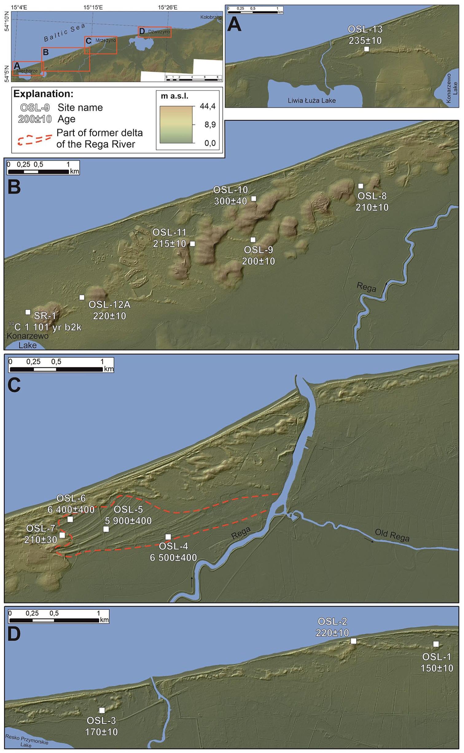
Dunes and their age in the study area. Source of DEM – IT system for the Country’s Protection Against Extreme Hazards (ISOK).
The thickness of the aeolian deposits in the interdune depressions is up to 10.7 m (BH W1). The grain size analysis of the aeolian deposits performed for 239 samples from 14 cores (BH: D1-D3, D5, O7, O9, S1, S2, S6, S7, S11, S13, W7, W13) revealed that the series is composed of fine, medium and sometimes coarse sand (Mz 0.91–2.38 φ). The standard deviation ranges from 0.16 to 0.97 φ. Samples with very well-sorted sand dominate. The proportion of well-sorted and moderately sorted sand is small. The skewness ranges from –0.50 to 0.30. Nearly symmetrical and negative skewed grain-size distribution curves are most common. The proportion of other groups is small. The kurtosis ranges from 0.72 to 1.93. Mesokurtic and platykurtic distribution curves account for the largest proportion. The proportion of other groups is small. In the mean size–standard deviation relationship (Figure 6), a decrease in the mean size value is observed with an increase in the standard deviation value. For the standard deviation–skewness pair, a decrease in the standard deviation value is accompanied by an increase in the skewness value. For the third pair for Mz > 2.0 φ, there is a decrease in the mean size value with a simultaneous increase in the skewness value. For Mz = 2.00–2.25 φ, the skewness value decreases as the mean size value increases. For Mz > 2.25 φ, there is an increase in the mean size value with a simultaneous increase in the skewness value.
The grain size analysis showed that the feature that distinguishes the aeolian sediments from other analysed groups is their very good sorting.
Aeolian accumulation in the study area has occurred since the last 6500 years. This is indicated by the OSL age of the oldest dune west of Mrzeżyno. The OSL age of the other dunes in the study area indicate their young age, ranging from 1101 yr b2k (site SR-1) to 150 years (site OSL-1; Figure 10; Supplemental Appendix 2 and 3, available online).
Peat
In the study area, peat was identified in the barrier deposits. It developed on the marine barrier sand and was subsequently covered by aeolian sand. Locally, peat occurs in the aeolian sand (interdune peat). In general, its spatial extent is limited.
In the vicinity of Niechorze, the discussed series was identified in six cores. The elevation of the peat bottom varies from 4.75 m b.s.l. (BH 770020 – The HYDRO Bank, n.d.) to 0.66 m b.s.l. (BH 36 – Dobracka, 2020, 2021), and its thickness is up to 4.8 m (BH 770020 – The HYDRO Bank, n.d.). The results of the pollen analysis performed for core 36 (Brykczyńska, 1976) indicate that the accumulation of peat ended in the early Subatlantic (middle Meghalayan).
In the vicinity of Mrzeżyno, interdune peat was found in 34 cores. Its bottom occurs at an elevation ranging from 4.74 m b.s.l. (BH 1[41-I] – Witkowska and Imach, 1968a) to 0.07 m b.s.l. (BH T1 – Cedro, 2016). The thickness reaches 3.5 m (BH 780042 – The HYDRO Bank, n.d.). The oldest radiocarbon age obtained from the bottom of peat from core T7 is 5854 yr b2k (Cedro, 2016). The youngest age from the peat top layer from core T27 is 895 yr b2k (Cedro, 2016).
In the vicinity of Dźwirzyno, peat in the barrier deposits was identified in five cores. Its bottom occurs at an elevation ranging from 1.94 m b.s.l. (BH 780004 – The HYDRO Bank, n.d.) to 1.14 m a.s.l. (BH 8[66-I] – Gumińska and Chochłowski, 1972). The thickness of the series in this area is up to 1.2 m (BH 780004 – The HYDRO Bank, n.d.).
The Rega River delta deposits
A former delta of the Rega River was identified in Mrzeżyno. The best preserved fragment is located west of the current mouth of the Rega River in Mrzeżyno (Figures 8 and 10c). On the eastern side of the river mouth, the relief was significantly modified due to the development of Mrzeżyno, which makes it impossible to recognise the delta in the relief. A system of parallel transverse dunes (discussed in the previous subsection) developed on its surface. The upper deposits of the Rega River delta occur at an elevation ranging from 4.0 m b.s.l. (BH 4[36-I] – Witkowska, 1964 and 780011 – The HYDRO Bank, n.d.) to 0.0 m a.s.l. (BH S10 and S13). The thickness of the series is up to 6.2 m (BH 780042 – The HYDRO Bank, n.d.).
The preserved fragment of the delta is about 2 km long (in W–E direction) and 0.5 km wide (in N–S direction). Taking into account the drilling data and the fact that the northern and western parts of the delta were masked by a younger generation of dunes, the actual size of the Rega River delta is larger and may reach approximately 3.5 km in the W–E direction and 2.5 km in the N–S direction.
The grain size analysis of the delta deposits was performed for 111 samples collected from three cores (BH: M1, O7 and S13). The results indicate that the series is composed of medium and fine sand, sometimes with admixture of gravel (Mz 0.02–2.85 φ). The standard deviation ranges from 0.27 to 1.92 φ. Well-sorted deposits dominate. There are also moderately, very well and poorly sorted deposits, but their share is small. The skewness varies between –0.65 and 0.26, with the highest proportion of very negatively skewed and negatively skewed grain-size distribution curves. The kurtosis ranges from 0.70 to 1.73. Leptokurtic and mesokurtic curves dominate with small share of other groups (very platykurtic, platykurtic and very leptokurtic). In the mean size–standard deviation relationship (Figure 6), a decrease in the mean size value was followed by an increase in the standard deviation value. For the standard deviation–skewness pair, a decrease in the standard deviation value was correlated with an increase in the skewness value. For the third pair (skewness–mean size), an increase in the skewness value was correlated with an increase in the mean size value.
The grain size analysis performed for the Rega River delta deposits revealed that their distinguishing feature in relation to glaciofluvial and fluvial deposits is better sorting. Compared to aeolian deposits, the Rega River delta deposits are characterised by the presence of gravel and slightly worse sorting. The analysis also showed that all the analysed grain-size textural parameters of the Rega River delta deposits are similar to those of marine barrier sand, with the difference that, in the case of skewness for the Rega River delta deposits, the proportion of nearly symmetrical curves is smaller compared to marine barrier sand, where they have the largest proportion. In the case of kurtosis, leptokurtic and mesokurtic distribution curves dominate in the Rega River delta deposits. For the marine barrier sand, mesokurtic curves dominate, with a much lower proportion of leptokurtic curves compared to the Rega River delta deposits.
Shells of marine molluscs Cerastoderma glaucum (Bruguière) and Macoma balthica (Linnaeus) were found in the Rega River delta deposits in core O7.
Holocene barrier coast development in the Pomeranian Bay area
The development of the Baltic Sea is closely associated with the disintegration of the Vistulian (Weichselian) ice sheet. Meltwater accumulating in front of the ice sheet formed ice-dammed lakes. About 14,500 yr b2k, ice-dammed lakes existing in the southern parts of the Bornholm and Gdańsk basins merged and formed the Baltic Ice Lake, which is the first development stage of the Baltic Sea (Andrén et al., 2011; Uścinowicz, 1999, 2003, 2014). The next development stages are the Yoldia Sea (11,700–10,700 yr b2k), the Ancylus Lake (10,700–9800 yr b2k), the Littorina Sea (9800–5500 yr b2k) and the Post-Littorina Sea (last 5500 years). These stages of the Baltic Sea development have been extensively described and discussed in the literature, for example, Eronen (1988), Hyvärinen (1988), Björck (1995), Andrén et al. (2011), Uścinowicz (2003, 2014), Rosentau et al. (2017). About 9800 yr b2k, the Ancylus Lake became connected with the Atlantic Ocean through the Danish Straits and the stage of the Littorina Sea began. A rapid rise in sea level, referred to as the Littorina transgression, resulted in the inundation of large land areas of the southern Baltic, including the present-day area of the Pomeranian Bay (Uścinowicz, 2003).
Based on the morphology and geological structure of the seabed derived from bathymetric maps, seismoacoustic profiles and cores (Dobracki and Zachowicz, 2007; Kramarska et al., 2016; Uścinowicz, 2003), the geological structure of the coast (Figures 7–9) and the sea-level curve (Figure 11) (Sydor and Uścinowicz, 2022), models of the barrier coast evolution during the Holocene in the Pomeranian Bay area were developed. When creating coast development models for the study area, it was assumed that hydro-meteorological conditions, including wind directions, longshore currents and wave climate, despite some climate oscillations, were essentially similar to those of today. In particular, it was assumed that the morphological parameters of the shoreface and processes occurring during the Holocene coastal evolution were similar to those of today.
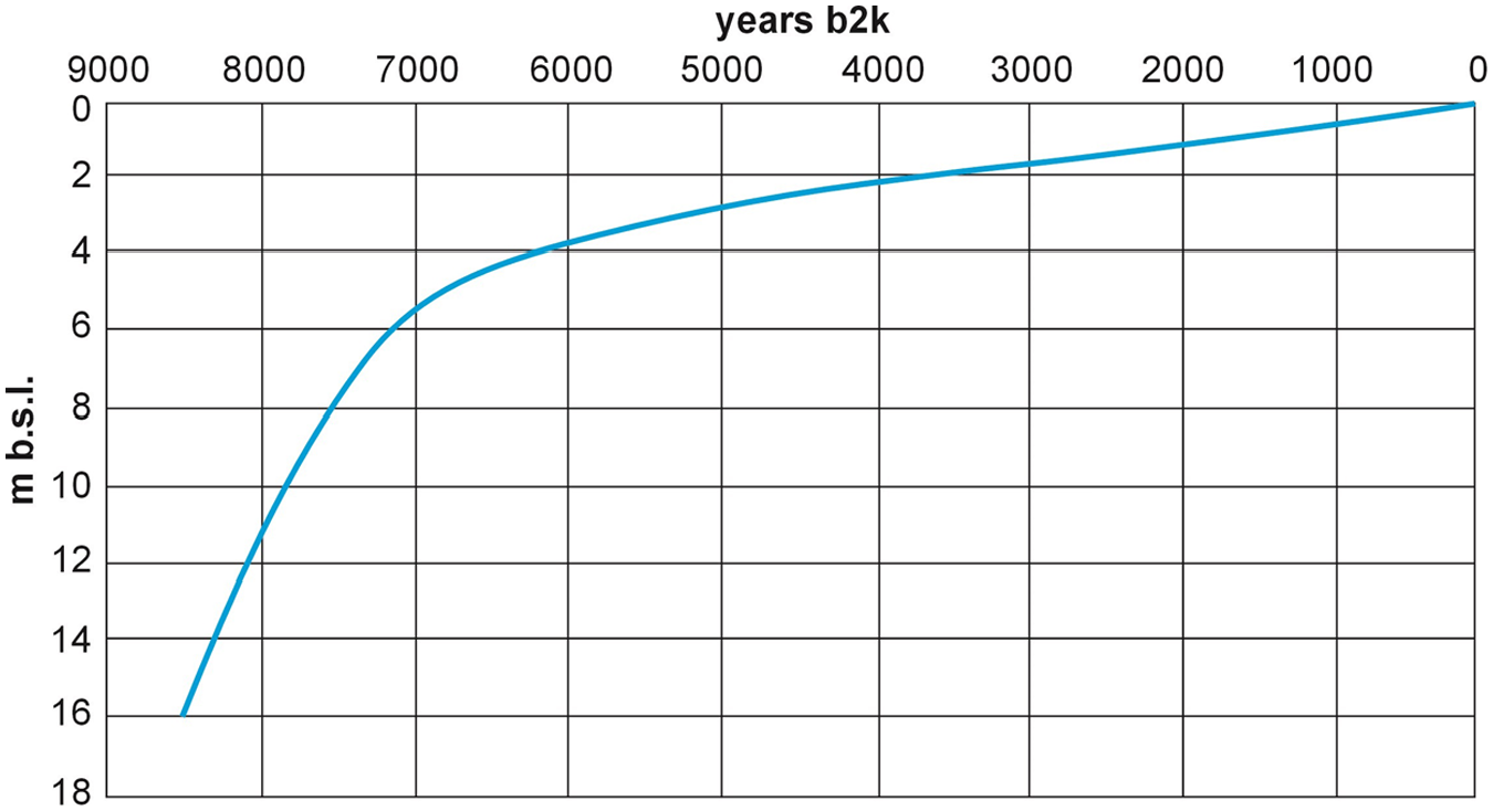
Simplified sea-level curve for the Pomeranian Bay (acc. to Sydor and Uścinowicz, 2022).
Greenlandian (11,700–8200 yr b2k)
During the Greenlandian, the area of today’s Pomeranian Bay was a region beyond the impact of the Baltic Sea. The landscape was dominated by lakes and peatlands. The Oder estuary existed in its western part (Borówka et al., 2002; Borówka et al., 2017; Jurowska and Kramarska, 1990; Kramarska, 1998; Kramarska et al., 2016; Kramarska and Jurowska, 1991; Figure 12a). At the end of the Greenlandian, around 8500–8200 yr b2k, when the sea level was 16–14 m lower than at present (Figure 11), a large part of the lakeland was flooded and transformed into a large lagoon (Figure 12b). The marine ingression took place from the north-west along the Oder estuary. The late Greenlandian lagoon was separated from the sea to the north by a barrier formed along the elevation of the Inter Pleni Vistulian sandy deposits, as evidenced by seismoacoustic and core data (Kramarska, 1998; Uścinowicz, 2003). It is likely that at that time the sandy Odra Bank was prograding along the eastern side of the former estuary, bounding the lagoon to the west.
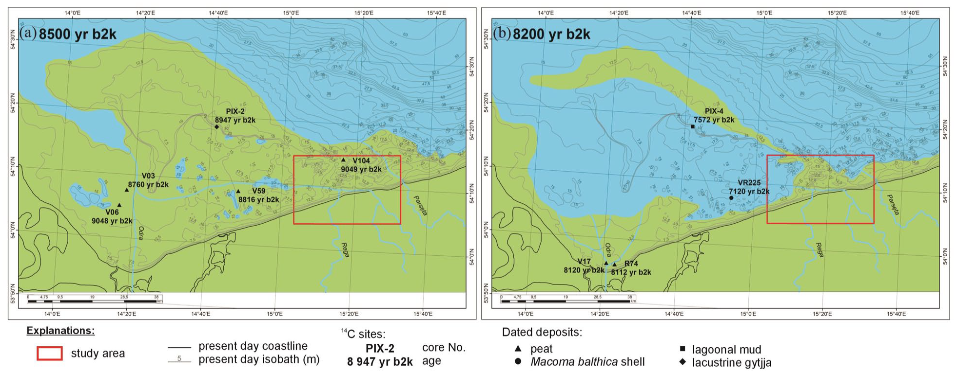
Palaeogeography of the Pomeranian Bay in the late Greenlandian: (a) 8500 yr b2k, (b) 8200 yr b2k. Core source data: Kramarska (1998): PIX-2, PIX-4, R74; Polish Geological Institute – National Research Institute archive: V03, V06, V17, V59, V104, VR225. Source of bathymetry: Polish Geological Institute – National Research Institute.
Early Northgrippian (8200–6000 yr b2k)
At the beginning of the Northgrippian (8000 yr b2k), when the sea level was about 11.5 m lower than at present (Figure 11), most of the study area was still land (Kramarska, 1998) (Figure 13). The coastline was located north of the present-day coastline from about 2 to 3 km in the western and eastern parts (Niechorze and Dźwirzyno areas) to about 12 km in the central part of the study area (Mrzeżyno area). The available data (Kramarska, 1998; Kramarska et al., 2016) suggest that a significant part of the coast in the study area was a barrier coast. The landscape was dominated by a morainic upland cut by valleys. The bottoms of valleys were located 5 m below modern sea level.

Palaeogeographical maps of the study area. Site source data: Tomczak (1995) for Grzybowo 337 km; Polish Geological Institute – National Research Institute archive for V104; Piotrowski et al. (unpublished, with permission) for R4; see Supplemental Appendix 1 and 2, available online for other cited sites. Source of bathymetry: Polish Geological Institute – National Research Institute.
Between 8000 and 7500 yr b2k, the sea level increased by ca. 3.5 m at a rate of ca. 7.0 mm/yr, and ca. 7500 yr b2k was 8.0 m lower than today (Figure 11). The coastline was located about 1.0–1.5 km north of its present position (Figure 13). The largest changes took place in the Mrzeżyno area. The coastline along this section retreated ca. 11 km in about 500 years, at an average rate of 22.0 m/yr. This was associated with the breaking of the barrier that existed between the Odra Bank and Kołobrzeg. This happened at the same time as the rapid sea transgression into the area of today’s Szczecin Lagoon (Borówka and Cedro, 2011; Borówka et al., 2001a, 2001b, 2002, 2005, 2017). It is yet to be determined whether this was a catastrophic event (Borówka et al., 2017; Rosa, 1963; Uścinowicz, 2003) or just a rapid (on a geological time scale) sea transgression. In other parts of the study area, the coastline migrated landwards by 1250–750 m at a rate of 2.5–1.5 m/yr. At many sites on the Polish coast, including the study area, barriers from this period, that is, formed under the conditions of rapid sea level rise, were low and narrow and they were often broken by storm (Uścinowicz, 2003). At the back of the barrier, lagoons have formed in the area of Niechorze and Mrzeżyno. The radiocarbon age of 7791 yr b2k (BH T28 – Cedro, 2016) determined for peat occurring in the lagoonal mud in the lower part of its profile indicates that the lagoon in the Mrzeżyno area existed in the early Northgrippian.
About 7000 yr b2k, the sea level was lower than today by ca. 5.5 m (Figure 11). In the period 7500–7000 yr b2k, the coastline retreated by 1000–450 m at an average rate of 0.9–2.0 m/yr and ca. 7000 yr b2k it was located from 0 to 700 m north of its present position (Figure 13). The barrier coast existed in the central and western part of the study area. As a result of sea level rise, a peatland located north-east of Niechorze was flooded and a new lagoon was formed. The existing lagoons in the area of Mrzeżyno and Niechorze increased their range towards the south. In general, barriers in the study area were still low and narrow and were most likely often broken by storms.
The Littorina transgression ceased about 6000 yr b2k. The sea level was 3.5 m lower than today (Figure 11). At that time, the barrier coast dominated in the study area. In the vicinity of Niechorze, the coastline was located close to its present position. In the Mrzeżyno area, the coastline was located ca. 630 m south (i.e. landwards) of its present position. In the Dźwirzyno area, the coastline was located 200–450 m north (i.e. seawards) of the present coastline (Figure 13). Over a period of 1000 years, between 7000 and 6000 yr b2k, the sea level rose by ca. 2 m and the coastline retreated from 200 to 650 m at an average rate of 0.20–0.65 m/yr. The barriers near Niechorze and Dźwirzyno were still quite narrow. Their width probably reached 150–200 m, except in the Mrzeżyno area where their width could have reached 800 m.
The Rega mouth was located ca. 1.5 km west of its present position. OSL dates (Figure 10c; Table 1) indicate that the delta, which is visible in the modern morphology, was formed between 6500–5900 yr b2k. The remains of the Rega river delta with a system of dune ridges marking stages of cone growth suggest that the former total size was ca. 5 km in the W–E direction and 3.5 km in the N–S direction. Rega river old delta has a relatively large size because the discharge of the river ca. 6000 yr b2k may have been slightly higher than today due to the humid climate typical for the Atlantic period (Borzenkova et al., 2015; Brykczyńska, 1976, 1978; Latałowa, 1982, 1992; Obremska and Cedro, 2012).
Late Northgrippian – Meghalayan (last 6000 years)
Between 6000 and 4000 yr b2k, the sea level rose from 3.5 to 2.0 m below the present one, at an average rate of ca 0.75 mm/yr (Figure 11). Despite the slow rise in sea level, coastal retreat prevailed. A large part of the headlands formed by Pleistocene glacial and glaciofluvial deposits was eroded, especially in the western part of the study area, and stretches of the cliff coast were replaced by barriers (Figure 13). In Mrzeżyno and in the area east of Niechorze about 4000 yr b2k, the coastline was located 200–400 m south of its present position. In the Niechorze area, it was close to the present-day coastline, while in other areas it was located 200 m north of its present position. In the Niechorze area, between 6000 and 4000 yr b2k, the coastline migrated 140–440 m southwards (landwards) at an average rate of 0.07–0.22 m/yr. In the Dźwirzyno area, the coastline retreated ca. 400 m at an average rate of 0.2 m/yr. In the Mrzeżyno area, in the period 6000–4000 yr b2k, the barrier prograded ca. 250 m seawards at an average rate of 0.125 m/yr. Progradation of the coast also took place in the Rega mouth, where a delta was formed. The longitudinal currents, which probably followed a similar direction in the period from 6000 to 4000 yr b2k as today, caused the Rega mouth to gradually migrate eastwards. Its mouth migrated ca. 600 m eastwards during this period. The supply of sand by the Rega River and the migration of its mouth was most likely the cause of the barrier enlargement west of Resko Przymorskie Lake near Mrzeżyno.
Between 4000 and 2000 yr b2k, sea level rose from 2.0 to 1.0 m below the present one, at an average rate of ca 0.5 mm/y (Figure 11). At that time, the barrier coast existed throughout the study area and progradation processes dominated. Progradation ranged from ca. 120 m near the Rega mouth to 430 m in the area east of Mrzeżyno. The average rate of coastal progradation at that time varied between 0.06 and 0.23 m/yr. The retreat of the coast occurred only east of Dźwirzyno. The range of the retreat was ca. 100 m, with an average rate of 0.05 m/yr. About 2000 yr b2k, the coast reached a shape similar to the present one, but for a considerable section the coastline was located between 60 and 200 m seawards. Only in the Niechorze area, the coastline was located 230 m landwards from its present position (Figure 13).
Radiocarbon dates for peat beneath the aeolian sand indicate that intense aeolian activity began in the early Meghalayan, which formed large aeolian covers and dunes (Figure 10). The northern part of the lake known today as Liwia Łuża Lake and the existing lake east of Niechorze were buried. In the Dźwirzyno area, aeolian sand covered the northern parts of Lake Resko Przymorskie and the valley located east of this lake. At that time, the aeolian sand entered the Rega River valley, covered the Rega delta and buried its mouth. The Rega turned eastwards, where, flowing in a flat and low-lying valley, entered Resko Przymorskie Lake. In the Mrzeżyno area, the aeolian activity and the expansion of the barrier towards the sea were accompanied by the development of peatlands that covered the barrier in its southern part.
About 2000 yr b2k, the sea level was 1 m lower than today (Figure 11). Most of the coast in the study area was exposed to marine erosion. Over the past 2000 years, the coast has retreated from 60 to 200 m, with an average rate ranging from 0.03 to 0.10 m/yr. A different trend was observed only in the area east of Niechorze, where the coastline prograded ca. 230 m at an average rate of 0.11 m/yr. In this period, the aeolian cover continued to expand, mainly in the Rega valley. At present, the entire barrier, except for small local plots, foredunes and the beach, is covered by pine forest. Therefore, no aeolian activity is observed.
In 1457 AD, a canal was dug in Mrzeżyno, which channelled the Rega River directly into the Baltic Sea (Riemann, 1873; Stoewer, 1897).
Discussion
Main types of barriers in the study area
The reconstructed stages of the barrier coast evolution indicate three different scenarios of the barrier coast development in the study area: barriers that evolved from retrogradational to progradational type, barriers that evolved from retrogradational through progradational to retrogradational type again, and barriers that have been retrogradational throughout their existence.
A barrier that evolved from the retrogradational to progradational type occurs in the western part of the study area near Niechorze. In this area, the retrogradational barrier existed in the period from 7500 to 4000 yr b2k (Animation 1; Figures 7 and 13). Continuation of the barriers landward migration despite a slowdown in sea level rise in the period 7000–6000 yb2k (Figure 11), was most likely due to sand scarcity. About 4000 yr b2k, the barrier evolved into the progradational type. This change was probably related to the climatic fluctuation around 4300 yr b2k. Climate cooling and aridification (e.g. Andersen et al., 2004; Mayewski et al., 2004; McDermott et al., 2001) was accompanied by an increase in the strength and frequency of storms (e.g. Goslin et al., 2018; Sorrel et al., 2012; Uścinowicz et al., 2022). Higher storminess caused increased cliff erosion west of discussed area and a larger sand availability. At the same time intense aeolian activity occurred in NW Europe (e.g. Clemmensen et al., 2001; Pedersen and Clemmensen, 2005; Reimann et al., 2011; Sommerville et al., 2007; Uścinowicz et al., 2021; Wilson et al., 2001). All of this resulted in the expansion of the barrier towards land and sea.
A barrier that evolved from retrogradational through progradational to retrogradational type occurs in the central part of the study area between Mrzeżyno and Dźwirzyno (Animation 2; Figures 8 and 13). The retrogradational type occurred in Mrzeżyno in the period 7500–6000 yr b2k and in Dźwirzyno in the period 7000–4000 yr b2k. This was followed by the progradational type, which lasted until 2000 yr b2k. Over the last 2000 years, the retrogradational type occurred again. The transition from a retrogradational to progradational barrier about 6000 yr b2k in the Mrzeżyno area was associated with the material supplied by the Rega River, which at that time formed a delta (Figure 10c) and probably had a greater discharge than at present. The situation was accompanied by a marked reduction in sea level rise (end of the Littorina Transgression) (Figure 11). In the Dźwirzyno area, the transition from the retrogradational to progradational barrier was additionally associated, as in the Niechorze area, with intense aeolian activity, which resulted in the formation of aeolian cover and dunes in this area (Figure 10d). Another change in the retrogradational barrier occurred around 2000 yr b2k, that is, when the mouth of the Rega River in Mrzeżyno was buried and the river changed its course towards Resko Przymorskie Lake. Thus, the supply of material from which the barrier was formed ceased in Mrzeżyno and Dźwirzyno areas.
The barrier that has been of retrogradational type throughout its existence is located between Dźwirzyno and Kołobrzeg and on a small section of the coast between Niechorze and Mrzeżyno (Animation 3; Figures 7, 9 and 13). In these regions, the barrier coast developed between 6000 and 2000 yr b2k, which is later than in the other parts of the study area. This was mainly due to the high elevation (above 5 m b.s.l.) of the barrier subsoil (Figure 5), which enabled the formation of the barrier coast only after a corresponding sea level rise. The emergence of the barrier in the discussed parts of the coast was not related to the slowdown in sea level rise, as it was most often worldwide, but mainly to the geological setting and morphology of the barrier subsoil. This barrier type is not only determined by the availability of sand, but mainly by topography and underlying geologic framework (McBride et al., 2013, 2022).
Main factors of the barrier coast evolution
The results of this study demonstrated that several factors affected the development of the coast in the Pomeranian Bay, including mainly climate variability, sea level changes, the amount of material supplied, aeolian processes, as well as the morphology of the barrier subsoil (accommodation space). The lithology of the barrier subsoil could also play an important role as a source of sediments for the barrier. Changes in sea level (Figure 11) and climate were very similar, if not identical, throughout the study area, while the morphology and lithology of the barrier subsoil varied (Figure 5). We are aware existence of many others factors (like neotectonics, compaction subsidence, changes in wave climate, human activities, etc.), that may affected on barrier coast evolution in the study area. However we did not discuss them due to lack of reliable data or minor importance for long term evolutionary trends. There is no studies on wave and current changes during the Holocene as well as the data about neotectonics of Polish coast are ambiguous.
Climate variability
Climate variability was the main factor in sea level changes and consequent coastal development in the study area, particularly in the first half of the Holocene (Greenlandian and early Northgrippian). Global warming and the melting of ice sheets in Eurasia and North America caused a rapid sea level rise (Engelhart et al., 2015; Lambeck et al., 2014; Loveson and Nigam, 2019; Meijles et al., 2018; Sloss et al., 2007). Similar situation was recorded in the Baltic Sea area (Bennike and Jensen, 1998, 2011; Hoffmann et al., 2009; Sydor and Uścinowicz, 2022; Uścinowicz, 2003; Uścinowicz et al., 2021). In the study area, the first traces of marine influence date back to ca. 8000 yr b2k, that is, when a rapid sea level rise occurred in the Baltic Sea (Littorina Transgression) (Figure 11). The slowdown in sea level rise occurred around 7000–5000 years b2k (Figure 11) with the melting of the last remnants of the Laurentide Ice Sheet in North America (Stokes, 2017).
Climatic changes, especially the alternating occurrence of warm and cold periods (Bond et al., 1997; Borzenkova et al., 2015; McDermott et al., 2001), also had a large impact on the variation in the frequency and strength of storms, as well as the intensity of aeolian processes (Clemmensen et al., 2001, 2009; Clemmensen and Murray, 2006; Pedersen and Clemmensen, 2005; Sommerville et al., 2007; Wilson et al., 2001, 2004). Similar pattern of frequent storms occurring during cold periods and transition between warm and cold periods are also recognized on the other coasts of the southern part of the Baltic Sea (Kylander et al., 2023; Uścinowicz et al., 2020; Uścinowiczet al., 2022). These periodical changes become particularly important in the last 6000 yr b2k, after the Littorina Transgression.
Studies of coastal dunes in Northern and Western Europe (Aagaard et al., 2007; Ballarini et al., 2003; Clarke and Rendell, 2009; Clarke et al., 2002; Clemmensen and Murray, 2006; Clemmensen et al., 2001, 2009; Sommerville et al., 2007; Wilson et al., 2001, 2004) revealed that climate in cold periods was characterised by less precipitation, stronger winds and higher frequency and strength of storms. Lower air humidity and stronger winds favoured the intensification of aeolian processes, while stronger and more frequent storms caused intensive abrasion of the coast, particularly the cliffs. This relationship is well evident in the study area in the last 4000 years, that is, during the Late-Holocene cooling, when large aeolian covers began to form (Figures 7–10 and 13).
Aeolian processes slowed down or even stopped in warm periods, characterised by more precipitation, higher humidity and lower frequency and strength of storms. In the study area, this relationship was evident during the Holocene climatic optimum in the Atlantic period, when climate was more humid than today. The Rega River had a larger discharge (which is indicated by the size of its delta – Figure 10c) and transported larger quantities of material for a barrier. As a result, a progradational barrier was present in the delta area (Figures 8 and 13; Animation 2).
Sea level changes
The rapid sea level rise played an important role in coastal development, especially in the Greenlandian and the early Northgrippian. Until the end of the Littorina Transgression, ca. 6000 yr b2k, intensive erosion and fast (up to 22 m/yr) retreat of the coastline prevailed in the entire study area (Figure 13; Animation 1–3). The slowdown in sea level rise meant that other factors, such as climate oscillations and the amount of material supplied, became critical.
The evolutionary model of coastal barriers for the western part of the Pomeranian Bay developed by Hoffmann et al. (2005) indicates that erosion plays a major role in shaping the coastline during rapid sea level rise. At this stage, the amount of material supplied was insufficient to compensate for the large accommodation space created during rapid marine transgression. The existing barriers were low and narrow. In the next stage, with a much slower rate of sea level rise, the accommodation space is reduced. Deposit accumulation is much more important than in the previous phase. A larger amount of material forms a barrier that starts to grow. Based on the above model, it can be assumed that the first stage in the study area corresponds to the period 7500–6000 yr b2k, when barriers were probably low, narrow and migrated landwards (retrogradational type). The next stage took place in the last 6000 years, when barriers were wider and the progradational type developed in some sections of the coast (Figure 13; Animation 1–3).
Amount of supplied material
The amount of material supplied is also an important factor affecting the development of the barrier coast (Deng et al., 2017; Racinowski and Pozlewicz, 2001; Zhang et al., 2017). In conditions of slow sea-level rise, the sediment budget could dominate the style of barrier evolution (Davies, 1980; Dillenburg et al., 2004; Psuty, 1988; Roy et al., 1994). The sediment that forms a barrier can be supplied from inland, updrift and offshore source areas (Fitzgerald and Van Heteren, 1999). Balanced budget conditions contribute to the development of an aggradational barrier, a positive balance budget contributes to the development of a progradational barrier, while a negative balance budget results in the development of a retrogradational barrier (Dillenburg and Hesp, 2009). Inland deposits from cliff erosion, as well as material carried by the Rega River are the main source of material supply in the study area. Material transported by longshore currents is accumulated in the nearshore, beach and coastal dunes. The importance of this factor is particularly evident when, ca. 2000 yr b2k, the Rega River changed its course towards Resko Przymorskie Lake (Figure 13). The supply of material ceased and the barrier changed from progradational to retrogradational (Animation 2).
Aeolian processes
Aeolian processes have played an important role in the barrier coast development in the study area, mainly in the Late-Holocene. The main factors affecting the intensity of aeolian process include climate variability and human activity.
The beginning of increased aeolian activity in the study area, resulting in the formation of large aeolian covers and dunes, correlates with climate cooling and drying ca. 4300 yr b2k (Bond et al., 1997; Borzenkova et al., 2015; McDermott et al., 2001), which initiated the Meghalayan (Walker et al., 2018) (Figures 7–10 and 13; Animations 1–3). Traces of increased aeolian activity in this period also occurred on other coasts of Europe (Clemmensen et al., 2001, 2009; Pedersen and Clemmensen, 2005; Sommerville et al., 2007; Wilson et al., 2001). On the Polish coast, increased aeolian activity and barrier expansion was recorded in the Świna Gate area –Troszyn II series (Borόwka et al., 1986; Reimann et al., 2011). Based on the results of TL dating and analysis of the digital elevation model of the Vistula Spit, Fedorowicz et al. (2012) concluded that increased aeolian activity took place in the late Northgrippian (6000–5000 yr b2k). Based on 14C dates of marine mollusc shells from barrier deposits and OSL dates of dune sand, Uścinowicz et al. (2021) suggested that the period of intense dune development and shoreface progradation on the Vistula Spit took place in the early Meghalayan (4000–2000 yr b2k).
The radiocarbon age of the fossil soil within the aeolian sand indicates that a slight reduction in the intensity of aeolian processes occurred in the study area (at least in certain areas) between 1160 and 452 yr b2k, that is, during the Medieval Warm Period.
The second factor affecting the intensity of aeolian processes is human activity. Pollen data (Brykczyńska, 1976, 1978; Brykczyńska and Więcławek, 1983; Latałowa, 1982, 1992, 1994; Obremska and Cedro, 2012) indicate that deforestation for agriculture and cattle grazing took place from the end of the Northgrippian, which contributed to the intensification of aeolian processes. In the mid-19th century, aeolian processes stopped as a result of human activity. In many regions of the Baltic coast, Scots pine was introduced on treeless dunes to stabilise them (Piotrowska, 1984). In the end of 19th century actions were taken to stop shore erosion by construction of concrete bands at the foot of the cliffs and groins to stop sand migrating along the shore as well as the breakwaters in Dźwirzyno and Kołobrzeg harbours were elongated.
Morphology and lithology of the barrier subsoil
Another factor affecting the development of the barrier coast is the morphology and lithology of its subsoil. The barrier subsoil is the surface on which barrier and lagoonal deposits accumulate (Dillenburg and Hesp, 2009). Differences in the morphology and lithology resulted in different barrier coast development histories in the study area. The oldest traces of barrier and lagoonal deposits were found in areas with the lowest subsoil elevation, that is, below 5 m b.s.l. These areas are located in Niechorze and Mrzeżyno (Figure 5). In this part of the study area, a barrier coast existed 7500 yr b2k, while the other parts featured a cliff coast (Figure 13; Animation 1 and 2). As the sea level rose, the barriers migrated landwards and covered lagoons located behind them. In these areas, mainly lagoonal deposits were found in the barrier subsoil (Figure 5).
The history of barrier coast development was different in areas where the barrier subsoil was located higher than 5 m b.s.l. These areas are located between Niechorze and Mrzeżyno as well as between Dźwirzyno and Kołobrzeg (Figure 5). In this part of the study area, the barrier coast appeared 6000 yr b2k (Dźwirzyno region), 4000 yr b2k (region between Niechorze and Mrzeżyno) and 2000 yr b2k (Kołobrzeg region) (Figure 13; Animation 3). The barrier that emerged in these regions covered small elevations of the Pleistocene surface and valleys, thus glacial, glaciofluvial and fluvial deposits are present in the barrier subsoil (Figure 5). No lagoon was present behind the barrier in these areas (Figures 7, 8 and 13; Animation 3).
Conclusions
The study provided an insight into the geological structure of the barrier coast in the eastern Pomeranian Bay and its evolution during the Holocene. This allowed the identification and characterisation of the main factors contributing to the development of the barrier coast.
Three main deposit types were identified in the study area: barrier subsoil deposits, barrier deposits and Rega River delta deposits. The barrier subsoil is represented by Pleistocene (glacial, fluviolacustrine, locally marine deposits of Inter Pleni Vistulian (MIS3), glaciofluvial and ice-dammed lake deposits) and Holocene deposits (peat, fluvial, lacustrine and lagoonal deposits). Barrier deposits are composed of marine barrier sand, aeolian sand and interdune peat. The barrier subsoil in the study area occurs at a depth ranging from 10 to 2 m b.s.l.
The identification of the geological structure allowed us to reconstruct the evolution of the barrier coast at the study site during the Holocene. In the Greenlandian, the area of the Pomeranian Bay was beyond the impact of the sea. The first traces of marine influence appeared at the turn of the Greenlandian and the Northgrippian. The coastline at that time was located 2–12 km north of its present position. During the rapid sea level rise (Littorina transgression), the coast retreated at a rate of up to 22 m/yr. In the study area, the barrier coast existed along small sections. Barriers at that time were low and narrow. In the late Northgrippian (ca. 6000 yr b2k), the rise in sea level slowed down (end of the Littorina Transgression). The rate of coastline landward migration dropped to 0.22 m/yr and the barrier coast began to dominate in the study area.
The analysed data revealed that there were three different types of barrier coast development histories in the study area: a barrier that evolved from retrogradational to progradational type, a barrier that evolved from retrogradational through progradational to retrogradational type, and barrier that was retrogradational throughout its existence.
Geological data and the reconstruction of the barrier coast evolution in the Holocene indicate that the main factors affecting the development of the barrier coast in the Pomeranian Bay are: climate variability, sea level changes, the amount of material supplied, aeolian processes, as well as the morphology and lithology of the barrier subsoil.
Supplemental Material
sj-jpg-1-hol-10.1177_09596836231163507 – Supplemental material for Driving forces and determinants of barrier coast evolution in the Holocene observed on the southern coast of the Baltic Sea
Supplemental material, sj-jpg-1-hol-10.1177_09596836231163507 for Driving forces and determinants of barrier coast evolution in the Holocene observed on the southern coast of the Baltic Sea by Paweł Sydor and Szymon Uścinowicz in The Holocene
Supplemental Material
sj-jpg-2-hol-10.1177_09596836231163507 – Supplemental material for Driving forces and determinants of barrier coast evolution in the Holocene observed on the southern coast of the Baltic Sea
Supplemental material, sj-jpg-2-hol-10.1177_09596836231163507 for Driving forces and determinants of barrier coast evolution in the Holocene observed on the southern coast of the Baltic Sea by Paweł Sydor and Szymon Uścinowicz in The Holocene
Supplemental Material
sj-JPG-3-hol-10.1177_09596836231163507 – Supplemental material for Driving forces and determinants of barrier coast evolution in the Holocene observed on the southern coast of the Baltic Sea
Supplemental material, sj-JPG-3-hol-10.1177_09596836231163507 for Driving forces and determinants of barrier coast evolution in the Holocene observed on the southern coast of the Baltic Sea by Paweł Sydor and Szymon Uścinowicz in The Holocene
Footnotes
Acknowledgements
We would like to thank two anonymous Reviewers whose valuable comments improved the manuscript.
Funding
The author(s) disclosed receipt of the following financial support for the research, authorship, and/or publication of this article: The project was funded by two statutory research grants from the Polish Geological Institute – National Research Institute: ‘Origin and coastline changes of the Trzebiatowskie Coast in the Late Glacial and Holocene in the light of paleogeographic research’ (project No. 61.2701.1101.00.0) and ‘Development of barrier coast in the eastern part of the Pomeranian Bay’ (project No. 61.2701.1601.00.0).

Supplemental material
Supplemental material for this article is available online.
References
Supplementary Material
Please find the following supplemental material available below.
For Open Access articles published under a Creative Commons License, all supplemental material carries the same license as the article it is associated with.
For non-Open Access articles published, all supplemental material carries a non-exclusive license, and permission requests for re-use of supplemental material or any part of supplemental material shall be sent directly to the copyright owner as specified in the copyright notice associated with the article.


