
Abstract
In this paper, we use geoarchaeological and paleoenvironmental data from three localities in the Yellow River Valley, China – Taosi, Sanyangzhuang, and the Yiluo Valley – to argue that human activity in the mid- to late-Holocene contributed to large-scale changes in the behavior of the Yellow River and that these changes were of sufficient magnitude to bend the arc of China’s history. Massive anthropogenic landscape transformation from the later Neolithic into the early Dynastic periods, especially in the Chinese Loess Plateau, increased sedimentation in the Yellow River requiring intensive investment in flood control features to protect an ever-growing population. As the Yellow River channel aggraded, channel gradients became increasingly steep, and avulsions occurred with greater frequency and consequence. Flooding reached an apogee in the first decades of the Common Era when a massive avulsion of the Yellow River ca. 14–17 CE caused the river to shift to the south and east of its former channel. This avulsion and the catastrophic flooding that followed triggered the collapse of the Western Han dynasty. The Yellow River – known as ‘China’s Tribulation’ – has been seen as a natural scourge that afflicts the inhabitants of the fertile North China Plain. However, when viewed in an Anthropocene perspective, it is evident that China’s Tribulation largely is the result of human manipulation of the environment.
Introduction
Background
China’s Yellow River is widely known as ‘China’s Tribulation’ or the ‘River of Sorrow’ (Wu and Ge, 2005) because of its frequent flooding and course changes through history. China’s Tribulation is a powerful symbol of the capriciousness of the Yellow River, suggesting that the river is beyond human control and that it is naturally dangerous, unpredictable, and untamable. An Anthropocene perspective, though, challenges this story of forbearing people contending against a capricious river. For the last 5000 years, humans have shaped the Yellow River, both inadvertently and actively, such that the behavior of China’s Tribulation is the outcome of a complex amalgam of human and natural processes. Anthropogenic alteration of the environments of the Yellow River watershed and direct engineering of the Yellow River itself made humans the primary geomorphic agent affecting the river by ca. 3–2 kya. Human actions, and the ways they amplified climatic and geological circumstances through time, are largely responsible for the massive flooding and catastrophic results for which the Yellow River is known by the early dynastic period.
We use case studies from three locations – the Taosi site, the Sanyangzhuang site area, and the Yiluo Valley (Figure 1) – to argue for an Anthropocene hypothesis that incorporates a variety of effects on the landscape over time. Between 5 and 2 kya, Chinese societies altered many otherwise natural processes in the Yellow River watershed, and in doing so changed the course of their own history. This evidence joins with other data to show that there is an unexpectedly early anthropogenic footprint in numerous parts of the globe (Ellis et al., 2013a: Figure 1; Redman, 1999, 2004; Wilkinson, 2010).
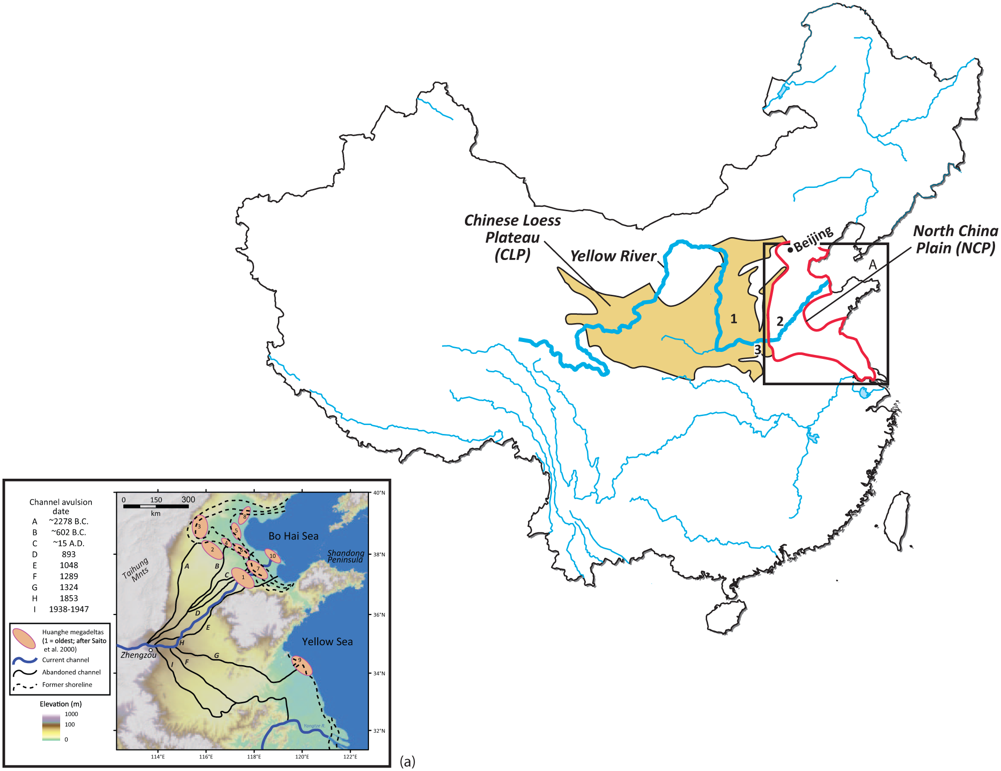
Map of China showing locations of the Chinese Loess Plateau (CLP), North China Plain (NCP) and sites or site locations discussed in the text (1: Taosi; 2: Sanyangzhuang and Anshang locality; 3: Yiluo Valley, where Erlitou and Han-Wei Luoyang are located). The black rectangle shows the location of inset map A, which indicates the approximate locations of the Yellow River and Yellow River megadeltas in the late-Holocene.
Geography
The Yellow River originates in the Tibetan-Qinghai Plateau and flows through the Chinese Loess Plateau (CLP) (Figure 1). The CLP covers ~640,000 km2 in northwest China and is composed of thick Pleistocene-age loess deposits (Wang et al., 2006). Although loess is well suited for agriculture (Catt, 2001), the silt-sized soil skeleton of loess promotes deep penetration of water into the ground surface (Shi and Shao, 2000); in most regions of the CLP, this soil condition coupled with a semi-arid environment means that vegetation is largely confined to limited numbers of trees, shrubs, and grasses (Li et al., 2003; Shang and Li, 2010). Meager plant cover and the loose soil structure of loess result in continuous soil erosion and gullying.
Over the Holocene, an estimated annual average of 0.8 × 10⁹ tons of sediment washed down from the CLP into the Yellow River (Shi et al., 2002: 280). Once it enters the North China Plain (NCP) east of modern Luoyang (Figure 1), the transport capacity of the river is surpassed by the sediment load resulting in rapid aggradation (Liu and Jiyang, 1989: 223–224). The river’s bed and banks are prone to erosion because they are composed of relatively coarse-grained sediments that lack structural cohesion (Chien, 1961; Jing et al., 1995: 484–485). Channel switching and avulsions are common as the channel aggrades and the slope differential between the channel bed and the surrounding floodbasin increases. Because of high sediment load and unstable bank conditions, the Yellow River Holocene alluvial floodplain is characterized by rapid sediment accumulation and thick sediment deposits (Jing et al., 1995; Wu et al., 1996a; Xu, 1998, 2003; Xu et al., 1996).
For much of the Holocene, the lower Yellow River flowed north to discharge in the Gulf of Bohai (Saito et al., 2000, 2001; Wu et al., 1996a; Xu, 1989; Xue, 1993; Ye, 1989: Figure 1). Avulsions in Western Han times (206 BCE–23 CE) shifted the course eastward (Wang and Su, 2011). At the end of the Northern Song Dynasty (960–1127 CE), the river relocated southward from its ancestral course (Lamouroux, 1998; Zhang, 2009). Between 1128 and 1855 CE, the main trunk of the river flowed almost due east to the Yellow Sea. An avulsion east of Kaifeng in 1855 diverted the river northward into its current channel (Jing et al., 1995: 285–286; Xu, 1989) (Figure 1a).
Climate
Over the Holocene, the East Asian monsoon has altered between strong and weak periods. Strong monsoon periods bring moisture farther into the continental interior. During weak periods, the monsoon boundary retreats south and east, resulting in less moisture reaching the interior (An et al., 2000; Cai et al., 2010; Clift and Plumb, 2008; Cosford et al., 2008; Maher, 2008; Selvaraj et al., 2007; Tan et al., 2009, 2011a; Yancheva et al., 2007). These trends are punctuated by years of abnormal weakened summer monsoons associated with El Niño. Strong El Niño events result in extreme aridity in central China (Wen et al., 2000).
Most parts of North China experienced warmer temperatures and greater precipitation between 7 and 5 kya (An et al., 2000, 2006; Cosford et al., 2008; Dong et al., 2010; Dykoski et al., 2005; Morrill et al., 2003; Wu et al., 2012; Zhai et al., 2011; Zhang et al., 2011). The so-called Holocene Optimum (HO) developed asynchronously across China and demonstrates temporal and spatial differences in temperature and precipitation (An et al., 2000; He et al., 2004; Wang et al., 2010). Middle Holocene cultural expansion coincides with the onset of the HO (Shi et al., 1993).
Increasing aridity defines late-Holocene (following ~4200 cal. BP) climates in north China (Zhang et al., 2011). Moisture availability became increasingly uncertain and conditions generally were adverse for plant and crop growth (An et al., 2006; Dodson et al., 2013). Climate records suggest that the frequency and amplitude of drought and flood events were increasing between 3 and 2 kya, and this information is also apparent in the historical records (although the latter data probably reflect reporting bias) (Ban, 1962; Hsu, 1980: Table 12).
Case studies
Background
The early and middle Holocene was a period of growing landscape control in China; plant and animal domestication was proceeding, but subsistence practices were highly varied (Flad et al., 2007, 2010; Fuller et al., 2007; Liu and Chen, 2012). Steadily increasing populations were leaving a growing environmental footprint through expanding landscape clearance for settlements, agriculture, and greater technological investment in pottery and other tool production (Mo et al., 2010). Human activities were increasingly indelible, marking the onset and expansion of new relationships between people and their physical world. By ca. 5–4 kya, populations throughout the Yellow River drainage reached new highs (Wagner et al., 2013: Figure 5). Pollen data show that vegetation shifts were considerable (see Zhuang and Kidder, 2014: Table 1), while charcoal records reflect more and more use of fire for land clearance and other activities (Hu et al., 2010; Li et al., 2009; Xu et al., 2002). Soil and sediment proxy data demonstrate that humans were modifying fields at an ever-increasing rate and with greater intensity (Song, 2011). Agricultural innovation and expansion were also critical in shaping human–land interaction.
Erosion at Taosi
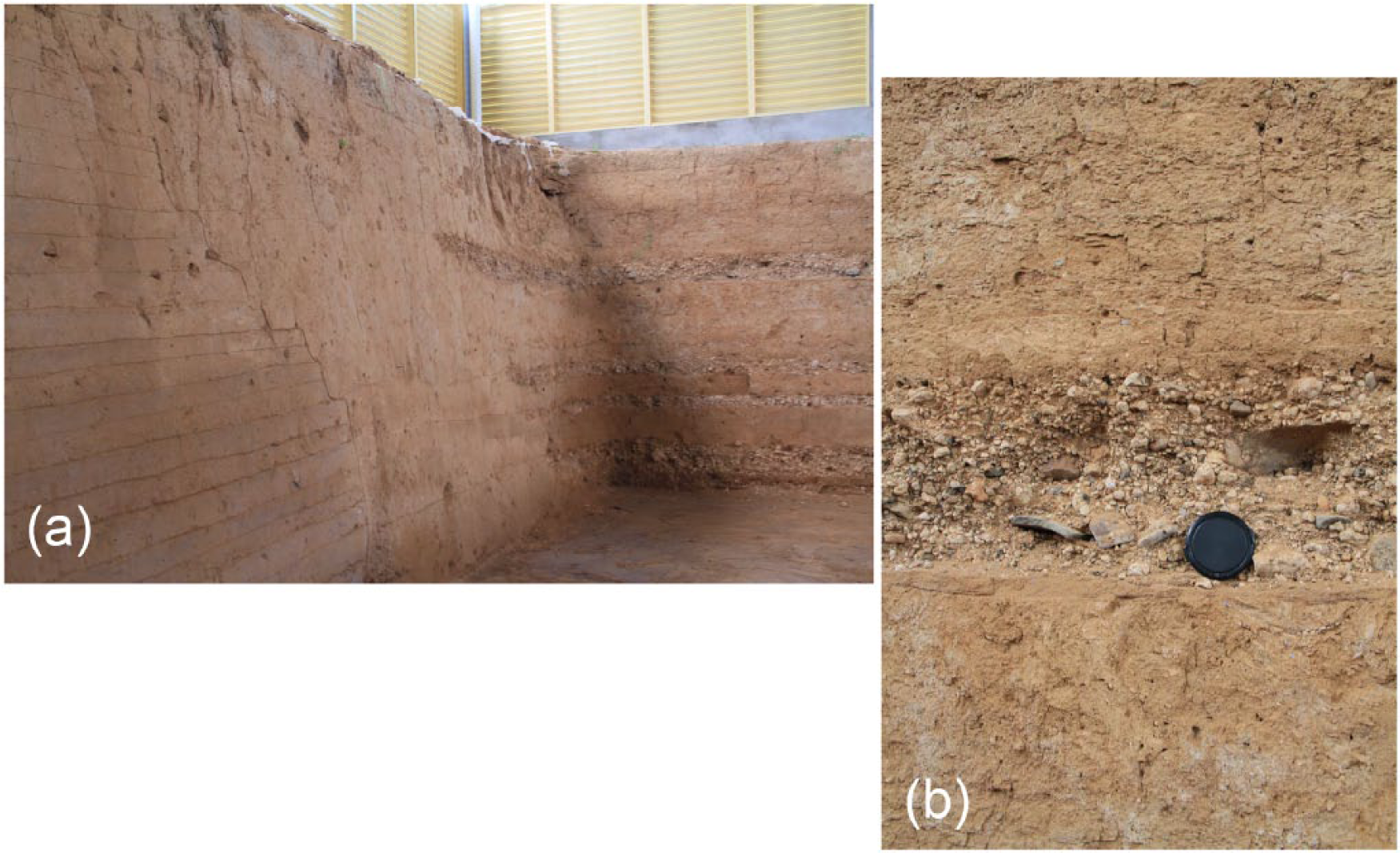
Taosi is a massive late Neolithic walled site located in the Linfen Basin in the Fen River valley. The occupation at Taosi is divided into three periods – early, middle, and late – that span ca. 4300–3900 BP. At its height, Taosi encompassed roughly 300 ha. The early and middle period city was enclosed by a rammed earth wall covering nearly 280 ha. The early and middle period occupation included elite residential and palace/temple areas with substantial rammed earth building platforms, a royal cemetery with roughly 10,000 graves, storage areas, craft production facilities organized into ‘industrial parks’ (He, 2013: 268), ritual precincts, and commoner habitations. Settlement survey has located 54 sites in the ‘Taosi cluster’. These sites range from small ‘villages’ (1–9 ha) and ‘secondary centers’ that range up to 200 ha, to the Taosi site itself. The Linfen Basin underwent a very rapid increase in population during the late Neolithic (Li et al., 2013). This local population increase may have been caused by growing aridity, which forced previously dispersed middle Neolithic groups into fewer but larger site clusters (Liu, 2004; Liu and Chen, 2012; Liu and Feng, 2012; Liu et al., 2004; Shao, 2000) located in favorable and relatively well-watered locales.
Investigations in the CLP demonstrate that surface erosion and material re-deposition were common ca. 4400–3900 BP (He et al., 2006; Huang et al., 2002a, 2002b, 2006a; Li et al., 2012; Zhang et al., 2010). At Taosi, the stratigraphic evidence points to human-induced erosion and the subsequent formation of gullies (He, 2013; Li et al., 2013) (Figure 2). Intermittent gravel layers indicate periods of intense high-energy hillslope erosion off the nearby Ta’ershan Mountains during and at the end of the site occupation. These thin erosion episodes that transported large gravel and boulder-sized clasts were absent prior to the site’s occupation and are not found following the abandonment of the site. With the construction of the large walled site, housing greater concentrations of people than in earlier times, timber consumption likely increased dramatically. Wood from trees and shrubs would have been needed for wall construction, house building, and fuel for fires for heat and for ceramic production. In addition, field clearance for agriculture and the effects of caprine grazing are also probable causes of increasing tree and shrub clearance (Brunson et al., in press). At Taosi, charcoal recovered from domestic contexts indicates that at least 25 tree species were being consumed (Wang et al., 2011), while palynological analysis shows a progressive decline in tree and shrub pollen following ca. 5000 cal. BP and a corresponding increase in genera that indicate clearance, such as chenopodiaceae and compositae (Li et al., 2014: Figure 3). Analysis at archaeological sites in the CLP indicates that there are increases in charcoal concentration and herbaceous pollen from 5000 to 4000 BP (Hu et al., 2010; Li et al., 2009; Xu et al., 2002). These data point to intensified biomass burning and vegetation change associated with human settlements across the region (Huang et al., 2003, 2006a, 2006b, 2007; Marlon et al., 2013; Ren, 2000; Tan et al., 2005, 2011b; Wang et al., 2013).
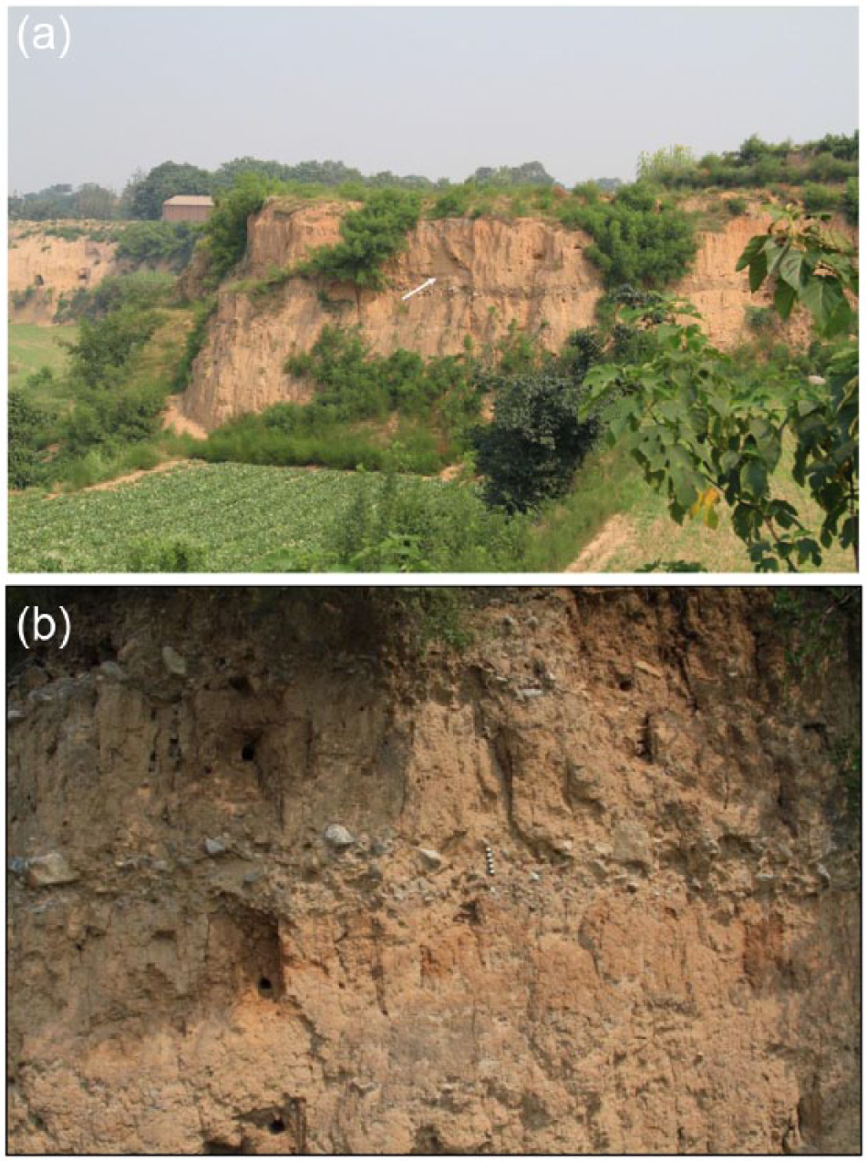
Erosion deposited gravel layers at Taosi. (a) View of site, looking NE across the Zhongliang Gou gulley. Arrow points to a thin gravel layer above a massive basal gravel bed. The basal gravels were deposited ~4600 cal. BP; subsequent gravel beds above this indicate periods of episodic erosion during and immediately following the site occupation. (b) Close up of gravel (and cobble) layers within site matrix. OSL sample locations can be seen on left (reported in Li et al. (2013)). Scale is 10 cm.
Eroded materials from Taosi and contemporary sites in the CLP were transported into the Yellow River. Shi et al. (2002) constructed a model for sedimentation-rate changes in the lower reaches of the Yellow River and suggest a three-stage evolution of average sedimentation rates from 0.2 cm/yr from ~11,000 to 7500 BP, through 0.25 cm/yr from ~7500 to 3000 BP, to 0.22 cm/yr from ~3000 BP to the present. Other analyses support this pattern. Xu (1998, 2003), using a similar method, argues there are two evident changes in ‘temporal variation in mean sedimentation rate’ of the Yellow River, one starting ca. 5000–4800 BP and the other from ca. 1400 BP. Xu argues that the trend prior to 5 kya is the result of climatic conditions associated with growing aridity, while following 5 kya the sedimentation rate is increasingly driven by anthropogenic factors. These sediment increases suggest that increasing deposition in the NCP is the result of greater erosion in the upper and middle reaches of the Yellow River, some of which appear to be enhanced by human landscape modification such as is seen at Taosi.
Flooding in the NCP
These sedimentation-rate data, however, represent a generalized pattern that masks considerable temporal and spatial variability. Research at Sanyangzhuang and nearby sites provides us with a picture of the long-term effects of anthropogenic changes throughout the Yellow River drainage (Kidder and Liu, 2014; Kidder et al., 2012a, 2012b). The study area is located east of the main trunk of the Yellow River up through the end of the Western Han occupation (Figure 3). The composite Holocene stratigraphy of the region extends to 12–13 m below the modern surface and is composed of multiple stable buried surfaces (paleosols) interspersed with Yellow River flood deposits. Through time, the periods of stability are shorter and flooding more common (e.g. Kidder et al., 2012b: Figure 5). In addition, the landscape itself reflects increasing evidence of unambiguous anthropogenic modification related to managing the Yellow River and to the intensification of food production.
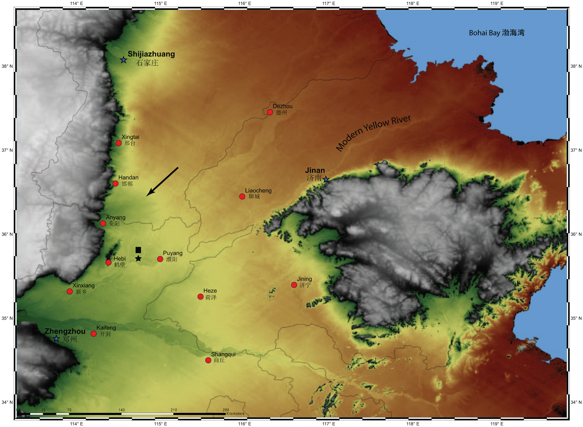
Map of part of the North China Plain, showing the location of Sanyangzhuang (black circle) and Anshang (black rectangle). Symbols are not to scale. Gray shades are mountains; darker shades represents higher topographic elevations within the floodplain while lighter shades are the lowest elevations. The solid black arrow points to the Zhang River alluvial fan discussed in the text. Modern cities are represented by red dots and provincial capitals are shown as stars. Provincial boundaries are shown by thin black lines.
At Sanyangzhuang, a paleosol formed on a Yellow River flood deposit between ca. 5.9 and 4.9 kya cal. BP. The base of this paleosol is extensively bioturbated. An agricultural field with distinctive ridges and furrows (Figure 4) dated from 4140 to 3160 cal. BP was added to the upper part of this natural paleosol. Investigation over roughly 1 km2 indicates that this field is continuous across the surveyed area. A sharp drop in arboreal pollen in this period is coupled with increases in herbaceous species, poaceae, and a marked rise in Selaginella sinensis; these data indicate expanding clearance and associated human activities (Liu et al., 2013: Figure 3; see also Cao et al., 2010).
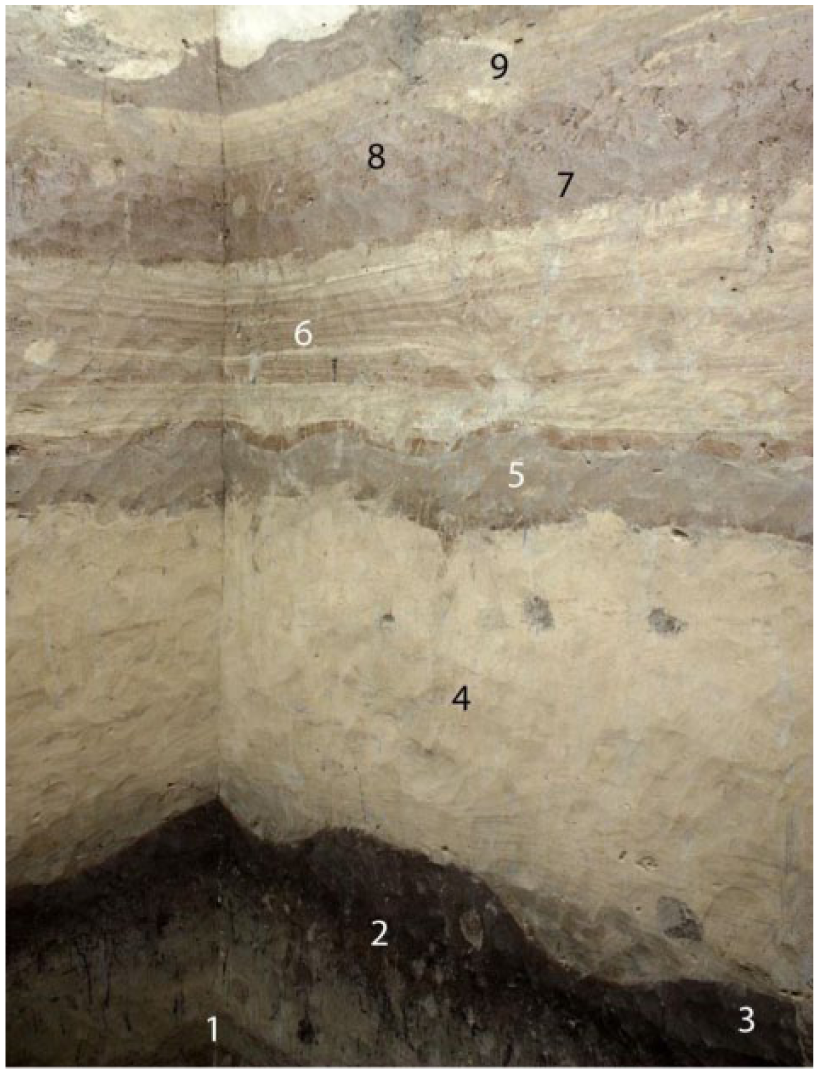
Sanyangzhuang Profile 1. Strata 2 and 3 are, respectively, the natural paleosol and the anthrosol dating to the Late Neolithic/Early Bronze Age. Note the extensive bioturbation at the base of 2 and the clear ridge-and-furrow pattern of 3. Stratum 4 is a massive Yellow River flood and 5 is a Warring States anthrosol with ridgesand-furrows. Stratum 6 is a laminated Yellow River flood deposit and 7 a Han Dynasty anthrosol. Note relative lack of bioturbation in 5 and 7. Strata 8 and 9 are Late Western Han flood deposits.
At Anshang, there is a contemporary paleosol but no corresponding evidence of agricultural field construction although micromorphological data show evidence of considerable anthropogenic disturbance. At Anshang, there are three ditches and an earthen levee (Figures 5 and 6). The ditches and the levee were sandwiched between two paleosols separated by Yellow River flood deposits. The youngest ditch began to fill ca. 2952–2792 cal. BP and was completely filled by 2859–2757 cal. BP (Kidder and Liu, 2014: Figure 6, Table 1). The levee at Anshang was stratigraphically superior to the three ditches but underlay a paleosol assigned by stratigraphic position to Warring States (475–221 BCE) times.
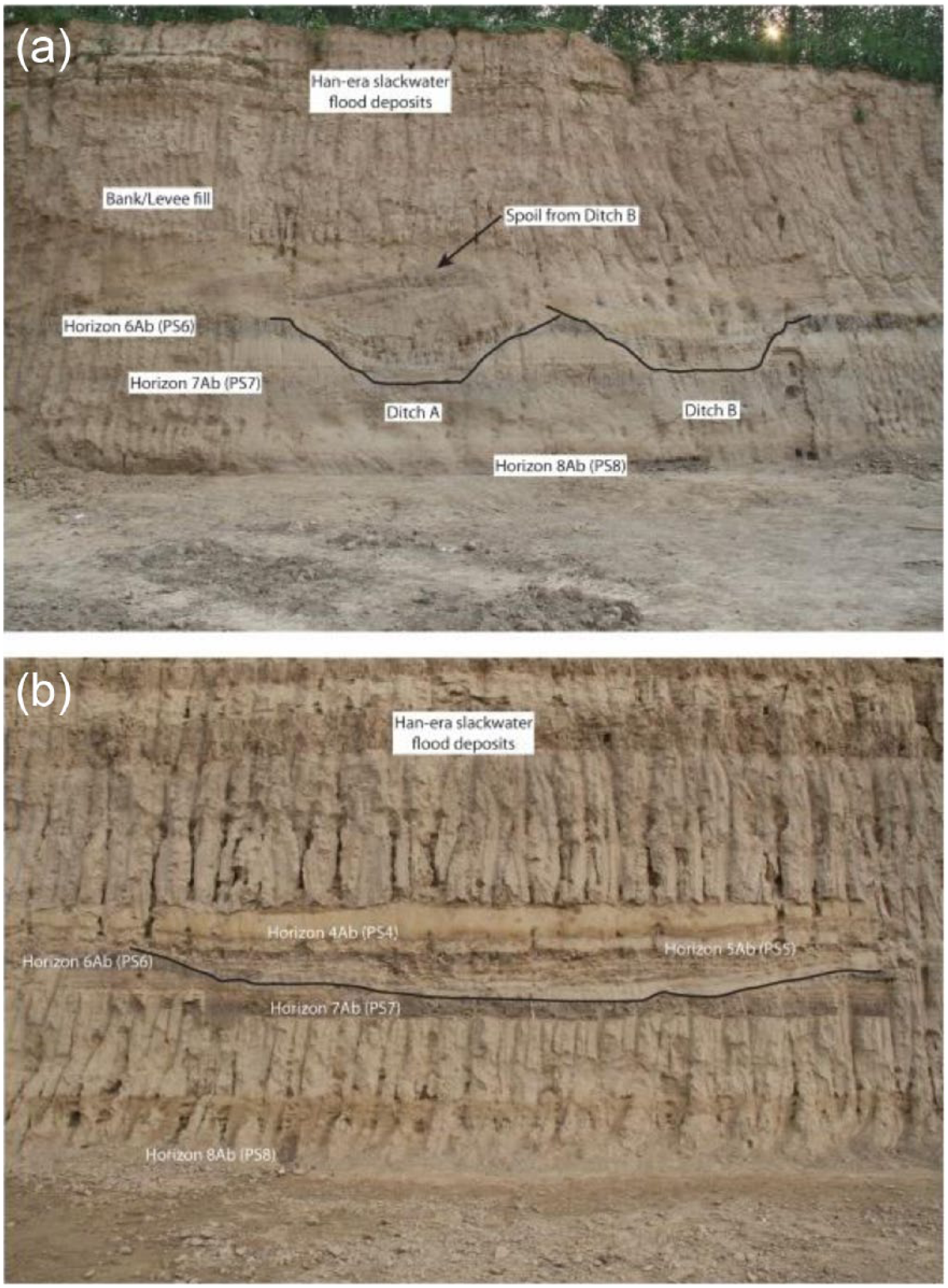
Western Zhou period irrigation ditches at Anshang. (a) Ditches A and B; (b) ditch C, which is perpendicular to A and B and is older based on stratigraphic relationships. Horizon 6Ab is a Late Neolithic or Bronze Age paleosol, Horizon 7Ab is a Middle Holocene paleosol, and Horizon 8Ab is a Middle to Early Holocene paleosol (see Kidder and Liu, 2014).
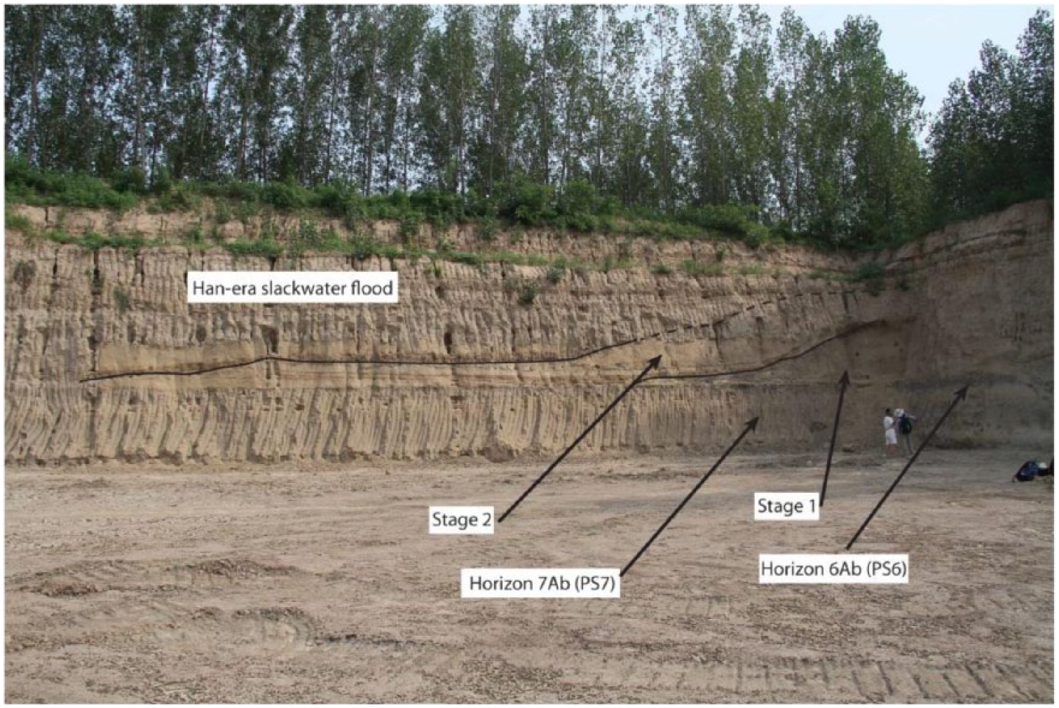
Artificial levee at Anshang, dated to later Zhou (Spring and Autumn period). Stage 1 is the earliest phase of levee construction, followed rapidly by stage 2, which increased the height and width of the levee. Horizon 6Ab is a Late Neolithic or Bronze Age paleosol while 7Ab is a Middle Holocene Paleosol (See Kidder and Liu, 2014).
The levee was built in two episodes; the first was a compacted, rammed earth core, roughly 2.5–3 m high with a 35- to 40-m-long landside berm. The second stage doubled the height, and the berm was extended to nearly 60 m. Little time elapsed between the construction of the first and second stages based on the lack of a paleosol or other indicators of bioturbation on or in the surface of the first construction stage.
Following the initial burst of anthropogenic landscape modification during the late Neolithic and Bronze Ages at Sanyangzhuang, there is a major Yellow River flood marked by a 1- to 1.3-m-thick massive deposit of silty sediment. At Anshang, contemporary flood deposits covered the landside of the Eastern Zhou Dynasty (ca. 760–221 BCE) levee. A Warring States-age paleosol formed on the surface of this deposit. At Sanyangzhuang (Figure 4, no. 5), a roughly 10- to 15-cm-thick Warring States period ridge-and-furrow agricultural field covers the surveyed area of the site. In contrast to the earlier field, which formed on/in a natural paleosol, the Warring States deposits were made before any natural soil forming activities could occur. Low levels of arboreal pollen, large amounts of herbaceous pollen, and abundant Selaginella sinensis indicate continued large-scale clearance and human landscape transformation (Liu et al., 2013: Figure 3).
The Warring States occupation was brief; another Yellow River flood occurred and the region was inundated. A prosperous Western Han Dynasty (206 BCE–9 CE) occupation is found on the surface of the Warring States flood deposits (Figure 4, no. 7) (Kidder et al., 2012a). The village consisted of multiple residential compounds situated in and among agricultural fields. Roads, field paths, wells, kilns, and looms complement the houses and extensive plowed fields. Contemporary structures and agricultural fields are found across a ~50 km2 area. The inhabitants were cultivating wheat and millet and processing silk worms. Ongoing extensive land clearance is shown by low levels of arboreal pollen, increases in the pollen of herbaceous and grass species, and a large amount of Selaginella sinensis (Liu et al., 2013: Figure 3).
The Han occupation at Sanyangzhuang spans ca. 132 BCE to 14–17 CE. A massive flood at the end of this occupation buried and preserved the landscape (Figure 7). The initial stage of this flood event was a catastrophic failure of the Yellow River levee west of Sanyangzhuang. A massive slackwater flood deposit is widespread throughout the region and serves as a marker bed for the late Western Han flood. The breach in the levee grew, however, and a coarse-grained, high-energy sediment splay was deposited across the region. In some locales, incipient paleosols formed, indicating that the splay evolved over time and with multiple anastomosing channels. The western part of the splay is 3–3.5 m thick and it thins on its margins.
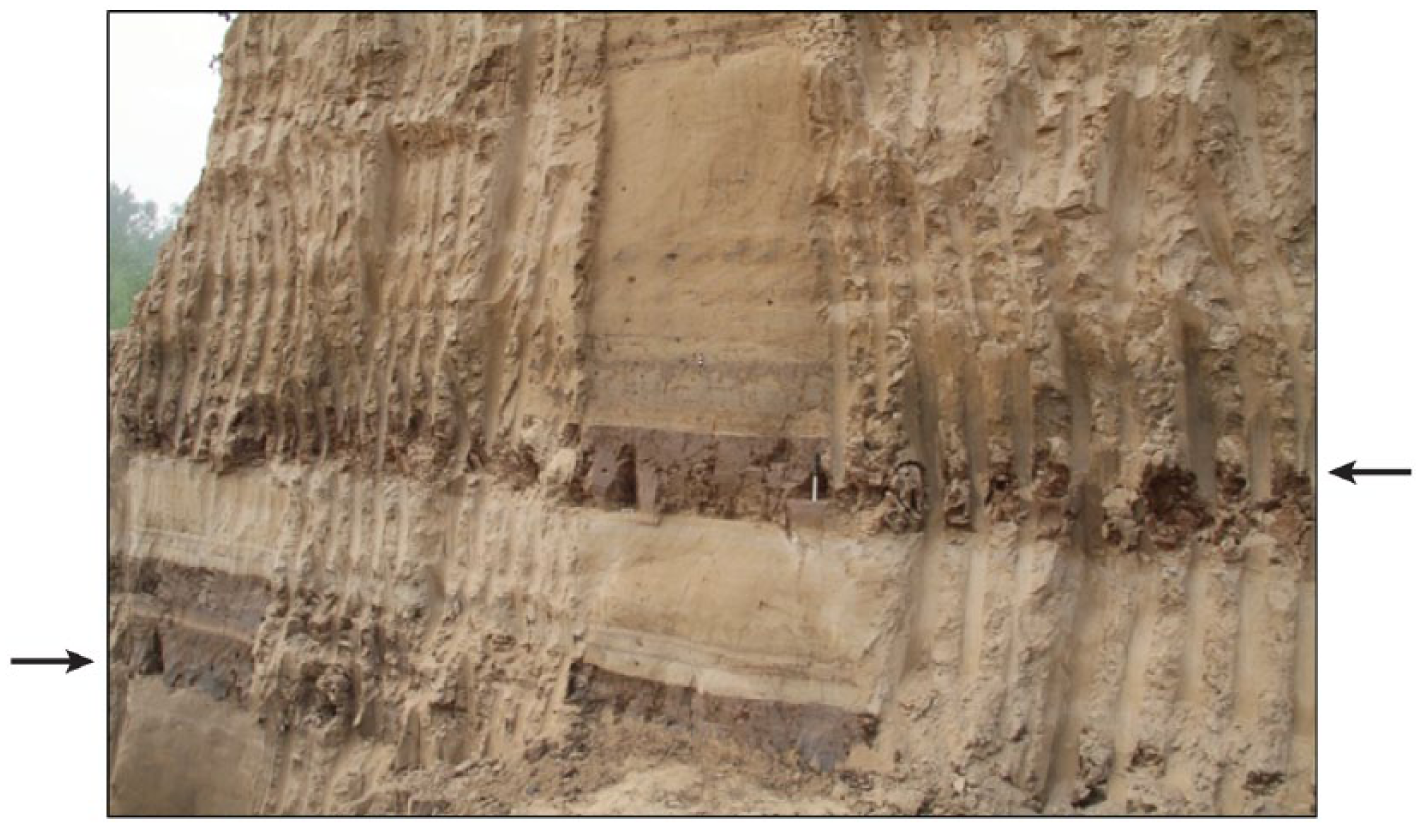
Flood deposits in the NCP dated to end of late Western Han at the Anshang site. The late Western Han flood deposits (between arrows) are marked by multiple thick red silty clay deposits sandwiching a massive Yellow River silt flood package. Similar deposits dated to the same interval have been noted at Sanyangzhuang (see Kidder et al., 2012a: Figure 4). The scale is 10 cm.
The Yiluo Valley
Further evidence of substantial anthropogenic transformation of the Yellow River landscape comes from work conducted in the Yiluo River Valley near the site of Erlitou as well as investigations at the Eastern Han (25–220 CE) and Wei (220–266 CE) Dynasty imperial capital of Luoyang (Figure 8). Our work at Erlitou was focused on exploring the history of the broad fluvial channel immediately south of the site. Extensive coring and three excavation units were used to understand the channel history. At Luoyang, we did reconnaissance level study of the erosion history at the NW corner of the city wall.
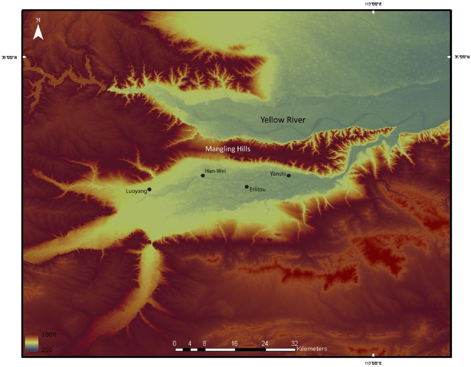
The Yiluo Valley. The Yellow River is visible north of the Mangling Hills. The site marked Han-Wei is ancient Luoyang, capital of the Eastern Han and Cao Wei dynasties. The modern city of Luoyang is shown to the west of Han-Wei Luoyang and the Bronze Age sites of Erlitou and Yanshi to the east of the Han-Wei site are marked.
The Yiluo Valley is located in the southeastern portion of the CLP within the middle reaches of the Yellow River catchment. The Yi and Luo Rivers are large perennial tributaries to the Yellow River that join east of modern Luoyang. The Yiluo Valley is historically important because it is an area with both an extensive archaeological record and because it has been home to some of China’s early political centers and dynastic capitals.
Rosen’s (2007, 2008) geoarchaeological investigations of the Yiluo Valley demonstrate that there is a significant and early human landscape footprint. With the arrival of middle Neolithic people ca. 7.2 cal. kya, long-term and large-scale changes are noted in drainages flowing into the Yiluo Valley from the southern flanks of the Songshan. A mid-Holocene stable land surface supported traces of human occupation and is associated with fine-grained, low-energy stream flows. Beginning ca. 7.2 cal. kya, there is an abrupt shift to a higher energy environment at several localities. An episode of greater stream capacity, channel aggradation, and floodplain accumulation lasted from the middle Neolithic Yangshao (~7000–5000 cal. kya) through the late Neolithic Longshan periods (~4600–3900 cal. kya) and came to an end sometime between 4.1 and 3.6 cal. kya. Massive gravel buildup at this time suggests that high-energy channel flow was linked to substantial soil erosion and gullying in the upper catchment that ‘was new in the Holocene sediment record of this region’. Tributary valleys feeding the Yiluo record an episode of valley filling associated with ‘compelling evidence for human management of this river floodplain during the Neolithic’. This pattern parallels that seen at Taosi and, we believe, provides further support for evidence that human modification of the river was contributing to local environmental transformations as well as large-scale modifications of the sediment budget in the downstream, NCP. This alluviation event comes to an end after the Longshan period, and there is no alluvial deposition within the study area from early Bronze Age or later. Rosen (2008) suggests this may be a consequence of climatically induced aridity that lowered Yellow River base flow leading to increased incision by high-order tributaries (pp. 304–305). As discussed below, though, there may be an alternative explanation for the absence of alluvial deposits.
Today, the Luo River is located on the north side of the Erlitou site and we were investigating whether the channel had been located on the south side before and during the Erlitou site occupation. We confirmed that the paleochannel was the course of the river up to the end of Western Han times when it was abruptly abandoned. The channel bed rapidly fines upward and a paleosol, OSL dated 3030 ± 270 to 870 ± 110 cal. BP, developed. The paleosol was truncated in Northern Song Dynasty times and the channel filled through intermittent flooding indicated by sequential fining-upward sediment packages.
The abrupt shift in the location of the Luo River channel to its current northward location is explained by a massive anthropogenic intervention. At the end of Western Han, the imperial capital was relocated from Chang’an, in modern Xian, to a location east of modern Luoyang (Bielenstein, 1976). As part of the construction of the planned imperial capital of Luoyang, the Luo River channel was canalized to flow at the southern boundary of the new city (Cotterell, 2008). This canal construction was part of a large-scale process of hydraulic engineering and river management undertaken throughout many parts of the Yellow River and its tributaries beginning in Warring States times and continuing into the Han (Needham et al., 1971; Sima, 2013: 1687–1701). Re-routing the Luo allowed goods transported from the nearby Yellow River to be brought directly to the capital and shaped the city so that it had a proper cosmological configuration (Cotterell, 2008; Wheatley, 1971), with the Mangling Hills to the north and the river at the immediate southern boundary. Thus, Luoyang replicated the layouts of earlier capital cities in the Yiluo Valley, including early Bronze Age Erlitou, Shang Dynasty Yanshi, and Eastern Zhou Wangcheng.
The construction of the imperial capital reconfigured the Luo River and significantly transformed the local environment. On the northeast side of the walls of Luoyang, we see evidence of rapid accumulation of colluvial flood deposits onlapping the city wall (Figure 9). These deposits show continuous colluvial accumulation punctuated by high-energy events that transported gravels and cultural remains. These deposits, which begin as soon as the city wall was constructed, suggest the Mangling Hills were denuded of vegetation at the onset of city construction. Increasingly massive human intervention at local and watershed scales led to further increases in erosion and downstream sediment accumulation, pushing the Yellow River toward a geomorphic threshold that led to river destabilization and avulsion by the end of Western Han.
Colluvial deposits at Han-Wei Luoyang. (a) View of multiple episodes of alternating fine- and coarse-grained sheet erosion deposits onlapping the rammed-earth city wall (visible on left); (b) close up of the uppermost coarse-grained erosion episode showing composition of rolled gravels, rounded CaCO3 nodules, and cultural materials.
Discussion
Climate, environment, and humans
Increasing aridity defines climate change in the Yellow River Basin over the middle to late-Holocene. A critical climatic effect is the way increasing aridity preconditioned (Bintliff, 2002) the landscape to erosion by limiting vegetation growth and inhibiting water infiltration. This effect was most keenly felt in the CLP, where topography and soil conditions inherently favor rapid erosion (Shi and Shao, 2000; Wang et al., 2006). Human expansion into the CLP during the HO, when climatic conditions were wetter and favorable for settlement (Liu and Chen, 2012), amplifies natural preconditions when climates changed for the worse and as intensification increased.
We speculate that climate change may also accelerate intensification of food production because with relatively high populations experiencing increasing aridity, and with limited land available for expansion, the only option was to deploy more effort in the same amount of land. Examples of these growing investments include the use of new crops in the Bronze Age and later, notably wheat (Dodson et al., 2013), wells in Neolithic and later times (Wang, 2001), increasing use of canals for irrigation (Needham et al., 1971; Sima, 2013: 1687–1701), and a rapid increase in new production technologies, including crop rotation strategies (Hsu, 1980; Song, 2011), novel plow types and agricultural technologies (Bray, 1978, 1979–1980), and new materials (notably metal). Trade, exchange, and especially warfare and territorial conquest also are a form of climatically stimulated intensification as societies that could not produce sufficient food and basic resources appropriated them through force.
Early Anthropocene intensification
The period from 5 to 2 kya represents an early episode of rapid intensification in the Yellow River Valley. Demographic change underpins much of the evolution of the Anthropocene in China. An increase in sites through the mid-Holocene documents the expansion of populations in the NCP and the CLP (Liu and Chen, 2012: 220–221; Wagner et al., 2013). This population expansion correlates with the relatively mild climates of the HO. Settlement contraction in Longshan times is offset by changes in settlement configurations. There were fewer Longshan settlements, but many are considerably larger; in areas such as the Linfen Basin, concentration of Longshan settlements of varying sizes indicates that spatial contraction may not tell the whole story. Populations increase, as do the sizes of the largest settlements, in the Bronze Age (Underhill et al., 2008; Wagner et al., 2013: Figure 3) and reach ~60 million at the time of the Han census of 2 CE (Ban, 1962: Di li zhi).
Technological innovation was a major force in the expansion of food production and political growth through military means. Ceramic production for vessels, molds for metal casting, and for industrial and architectural purposes, coupled with metallurgical invention, required expanded production and the political capacity to support it. The increasing use of animal traction, new agricultural technologies (Bray, 1978), and new agricultural strategies of field rotation, field amendment, irrigation, and drainage was also important (Hsu, 1980; Song, 2011). Between 3 and 2 kya, technological intensification expanded to industrial scales, with ceramics, iron, salt, fabrics, and other crafts being produced in large, often state-sponsored or controlled, workshops run by trained specialists (Pan, 1950). Metal weapons allowed Chinese states to wage war more efficiently and to field large armies that expanded the boundaries of the emerging centralized political system.
Growing state-level organization is closely linked with changing economic strategies (Ellis et al., 2013b). State-like if not truly state-level organization emerges in the late Neolithic and early Bronze Age (Liu and Chen, 2003, 2012; Shelach and Jaffe, 2014) and becomes increasingly entrenched through the Bronze Age. The emergence of an imperial state under the Qin (221–206 BCE) and its expansion during Han times mark a massive transformation in production and the control of economic processes. Pomeranz (2009) argues that the principal driving force behind political centralization ‘is a continuing increase in incentives and pressures to expand economic production’ (p. 10). He refers to this tendency as the ‘Developmentalist Project’, which constitutes a widespread socio-political endeavor found in a range of societies defined by practices of state-building, sedentarization, and resource intensification. Pomeranz specifically implicates the Developmentalist Project with increasing environmental degradation and growing resource consumption as states were compelled to bring more land into production and to settle more people on the land. By Han times, this feedback loop was inexorable, and once begun, it was difficult, if not impossible, to reign in.
The river transformed
The consequences of intensification are increasing anthropogenic interventions in the environment. An obvious effect is the transformation of the Yellow River. The Yellow River was largely stable through much of the Holocene, flowing in a northerly path along the western edges of the NCP. Large-scale flooding was uncommon and punctuated an otherwise long-term stable landscape up to ca. 5 kya. Erosion and sediment transport in the river began in earnest ca. 5 kya. Between 3 and 2 kya, growing populations in the CLP, using new and more efficient technologies and supported by intensified state-level infrastructure, expanded the amount of land under cultivation and the intensities of production per unit of land; erosion and sediment transport into the Yellow River increased as a result.
Sediment accumulation was growing after 5 kya with increasingly rapid buildup from 3 to 2 kya (Kidder and Liu, 2014: Figure 9; Shi et al., 2002; Xu, 1998, 2003). At Sanyangzhuang and Anshang, we see an uptick in flooding coupled with decreasing landscape stability. Natural paleosols did not have time to develop as populations in Warring States and Han times rapidly colonized formerly flooded habitats and transformed them to anthropogenic environments replete with fields, farms, roads, and industrial facilities. At Anshang, large-scale flood control and water management projects were ongoing by ca. 2.7 kya.
A major consequence of levee construction was increasingly rapid aggradation of sediments within the river bed because the river was now constrained in a limited channel. At Anshang, the levee was quickly raised again after the initial construction to cope with this challenge. By this point, the gradient between the river bed and the floodbasin at Anshang was ~2.5–3 m, and it was at least 3 m at Sanyangzhuang.
Flooding throughout the NCP is documented with increasing frequency in Han times. A series of large floods occurred in the first two decades of the Common Era. The most calamitous of these massive floods happened ca. AD 14–17 and buried an area up to 1800 km2 beneath a 3-m-thick sediment splay (Kidder et al., 2012a, 2012b). The area inundated by water from this flood event covered much of the low lying portions in eastern Henan, southern Hebei, western Shandong, and northern Anhui. With this flood and the associated avulsion, the Yellow River abandoned its trunk channel position held for up to 8000 years.
The Han flood of 14–17 CE was catastrophic across a vast region of north-central China. Soon after the flood, the region experienced widespread famine and large-scale social unrest followed. This area was an epicenter of popular discontent that was channeled into civil war and rebellion against the Emperor. The overthrow of the emperor in 23 CE has been attributed to the after effects of this flood (Bielenstein, 1954, 1959, 1986). The region witnessed unprecedented population loss associated with flood, famines, and the extensive political tribulations at the end of Western Han.
Yellow River avulsions cannot be solely attributed to anthropogenic effects. Climate, basin geometry, and natural sedimentation all play a role, but humans were the most important. For example, anthropogenic environmental change altered basin geometry along the western edges of the NCP. North of Anyang is a large alluvial fan of the Zhang River that extends into the floodplain from the Taihung Mountains (Wu et al., 1996b: Figure 6) (Figure 3). Forest clearance to fuel bronze production when Anyang was the Shang period royal capital and field burning associated with more intense agricultural production led to increasing erosion and fan accumulation (Cao et al., 2010). The fan’s progradation into the Yellow River floodplain effectively tilted the basin increasingly to the south and east, which would have magnified the slope gradient east of the aggrading Yellow River.
River base-level adjustment following the Han floods is another example. With a more direct channel to the sea, the base level of the river changed and the entire upstream river channel had to accommodate to these new conditions. Following the 1855 Tongwaxiang avulsion, the effects of erosion within the main channel could be immediately gauged for more than 100 km upstream (Qian, 1990: 8–9) and tributary systems compensated by incising their floodplains. Following the late Western Han flood, increased incision among higher order tributaries in the Yiluo Valley, for instance, magnified erosion and colluviation at sites such as Luoyang and may account for the absence of post-Neolithic sediments noted by Rosen (2008: 305).
Conclusion: An Anthropocene cycle?
Although China’s Sorrow has been understood as a natural condition, evidence suggests that it is part of a long-term Anthropocene cycle driven by feedback among natural and human circumstances. An intensification feedback loop emerges ca. 5 kya, is amplified ca. 3–2 kya, and defines the dynastic cycle from then on. Consistent population growth and expansion of populations into less or uninhabited lands is one element. This is associated with increasing emphasis on sustained, secure, and scalable food production, which is linked with technological innovation and economic infrastructure development. The feedback loop is made possible and given impetus by a strong, centralized political system with the ability to exercise dominion over people, land, and resources beyond the political and ethnic core of the original polity. Consumption of environmental resources is required to feed interactions among these variables.
Greater population, especially in the floodplain of the lower reaches of the river, requires increasing investment in fixed capital (notably landuse enhancements) to encourage and sustain production, which requires ever-growing investment in capital maintenance and improvement (Elvin, 2004: 120). In this area, a primary focus on investment was in managing the Yellow River through creation of levees and canals. By Dynastic times, as populations expanded the central government encouraged the migrations of people to the edges of empire. This policy had multiple goals. First, it relieved crowding in the NCP. Second, it provided a demographic bulwark against ‘Barbarian’ neighbors in the northwest, including the ecologically fragile CLP.
Both in the NCP and CLP, technology was required to enhance productivity. The most notable productivity enhancements focused on agricultural products, tools, and management practices. In the late Neolithic, it was new crops and crop rotation methods; by the Bronze Age, it was irrigation, field clearance, and new tools; in Han times, it was the widespread use of iron tools. These technological changes constituted a series of intensification revolutions that allowed various Chinese polities to expand agricultural production and to wage war that permitted territorial expansion and political consolidation. The downside of these practices was environmental degradation, especially in the CLP, as seems to be the case at Taosi. Following late Neolithic intensification, this degradation resulted in massive erosion within the Yellow River floodplain that accumulated by late Western Han times. This environmental transformation created China’s Tribulation and imperiled the productive resources of the NCP. The emphasis on technology also helped propel greater investment in fixed capital in the NCP. Technologies of river management were increasingly relied on as a way of protecting intensified investment of production in the fertile and highly populated alluvial floodplain. Although this pattern of technological intensification is especially notable in Dynastic times, we see it present in the Neolithic and Bronze Ages, albeit at smaller scales.
Increasing aridity through time is both cause and effect in this feedback loop. The retreat of the monsoon boundary heightened the environmental fragility of the CLP and increased natural erosion. The use of progressively more effective land clearance technology considerably enlarged the climate-driven effects of erosion on the CLP. These effects are notable at sites like Taosi and in the sedimentation rates of the Yellow River by the late Neolithic and only grow more pronounced with time. But climate change also probably pushed greater technological innovation and intensification as growing populations adapted to declining natural environmental abundance by other means.
The final cog in the process was political intensification. Although variable across space and through time, political centralization was a dominant force influencing the emergence and perpetuation of the Anthropocene condition in China. In the Chinese case, centralization took a number of forms and included growing political intervention in the economy, manipulation of taxes and economic policy to promote production, control of a vast and intricate bureaucracy, replete with highly controlled access to offices and power, political control of bodies by assigning (and, as needed altering) social status, and spatial segregation into administrative subunits dependent on the central bureaucracy. The political economy was supported and sustained by a heavy reliance on agricultural (and to a lesser extent, craft) production that gave incentives to farmers (and bureaucrats) to produce enough so that there was a surplus after taxes were extracted (Dubs, 1955; Huan, 1967; Loewe, 1974, 1986; Pan, 1950). Centralized polities require greater and greater resource intensification. In China, this is seen by repeated calls for increasing attention to the ‘fundamental’ (agricultural production) (e.g. see Huan, 1967). Furthermore, we see repeated instances of political expansion and the projection of economic, military, and political power outward beyond the boundaries of any given polity. This expansion allows states to gather more resources and to intensify domestic production. This in turn encourages the centralization of political power. In China, political expansion was accompanied by demographic shifts that placed larger and larger numbers of people in the fragile environments of the CLP. Because of this, tribulation, in the form of excess sediments, flowed down the Yellow River from the peripheries to the center. As exemplified by the Western Han case, anthropogenically driven environmental changes shifted the river’s threshold conditions leading to catastrophic flooding and sorrow. The result was reversion to a lower level of socio-political complexity. This pattern happens with the Han, the Tang, the Song, and the Qing (Dodgen, 2001). In each instance, Yellow River flooding stimulated by increased sedimentation associated with territorial expansion in the CLP and beyond consumed resources, caused flooding, and affected the state’s ability to govern.
China’s Tribulation neither is an entirely natural phenomenon nor is it wholly the product of human action. The intersection of environmental, climatic, and human forcings has shaped not only the Yellow River but also the history of China over the last 5000 years. Modern China is grappling with many of the issues outlined here. Complex demographic, technological, political, climatic, and environmental factors are shaping the nation’s fate, and the Yellow River sits at the heart of these matters. The Anthropocene is not an event but a process that evolves over considerable time and through the actions of many natural and human agents and agencies. This work shows that the roots of the modern Anthropocene are deep and tangled; however, if we are to understand the modern world, we need to recognize that we did not arrive here overnight.
Footnotes
Acknowledgements
We thank Mr Haiwang Liu (Henan Provincial Institute for Archaeology, Zhengzhou), Professor Duowen Mo and Mr Ren Xiaolin (Peking University, Beijing), Mr Zhen Qin and Mr Michael Storozum (Washington University in St. Louis), Dr Arlene Rosen, and the Henan Provincial Institute of Archaeology, Zhengzhou City. We are also indebted to the two anonymous reviewers for their thoughtful critiques and suggestions.
Funding
This research received no specific grant from any funding agency in the public, commercial, or not-for-profit sectors.