
Abstract
Agricultural societies around the world have dramatically altered the natural landscape, particularly through accelerated soil erosion. The expansion of agricultural land use into steeper headwater areas during the Medieval period in central Europe is known to have caused large increases in soil erosion and sediment redistribution downstream. Although land-use practices changed and improved following this initial impact, it is currently unknown whether changes in land-use techniques also improved hillslope soil erosion and sediment redistribution rates. In this paper, we use a variety of techniques, including chrono-stratigraphy, wood charcoal analysis and a geostatistical model, to reconstruct land-use and erosion rates for the period spanning the Medieval Period to the present (1100–300 years ago) in a small headwater catchment in central Europe. Coupling land-use, hillslope erosion and sediment redistribution fluxes, we find the largest flux change occurs because of the initial deforestation at the beginning of the Medieval Period (1100 years ago). Following deforestation, we identified three main types of land-use techniques that were practised between ~1100 and 300 years ago: Horticulture, cropping agriculture and rotational birch silviculture, the last of which represents the earliest evidence for this practice found in central Europe to date. However, we find only small differences in hillslope fluxes throughout the catchment despite the variable land-use techniques employed. This is because the land-use techniques primarily influenced and increased the hillslope sediment storage capacity rather than erosion rates directly, which is an important distinction to consider for future work attempting to link changes in human land use and hillslope erosion.
Keywords
Introduction
The introduction of agriculture profoundly changed natural landscapes across the world, with implications for the erosion and sediment transport of soil and the global carbon cycle (Hoffmann et al., 2013; Montgomery, 2007; Notebaert et al., 2011). Early human impacts during the past 6000 years in Europe are becoming increasingly well documented (Wilkinson, 2005), especially in terms of land cover change (Kaplan et al., 2009). However, agricultural land-use in the steeper upland areas of central Europe is not thought to have expanded until the beginning of the Medieval period (~1300 years ago) (Williams, 2000), when human settlement populations and the demand for agricultural products greatly increased (Bork, 1998). This is important since the clearing of steeper sections of catchments exposes soil with higher erosion potential, which can more easily be redistributed within the hillslope area as well as exported downstream into river and floodplain systems. Large increases in sediment supply and deposition rates because of these processes have been detected in headwater catchments themselves (Dotterweich, 2008; Fuchs et al., 2011; Larsen et al., 2013), within lakes and wetlands (Anselmetti et al., 2007; Zolitschka, 1998) and within larger river and floodplain systems downstream (Hoffmann et al., 2007, 2010; Notebaert and Verstraeten, 2010), with some lags in timing between the initial land cover change and downstream impact expected (Fuchs et al., 2011; Lang and Hönscheidt, 1999; Larsen et al., 2016). The duration of these time lags may also have some dependence on the cultivation techniques employed after vegetation was cleared, for example, the construction of field terraces (Bork, 2006; Tarolli et al., 2014).
Beyond the increase in hillslope erosion following initial deforestation, an important question in many landscapes of central Europe is whether the land-use practices that continued to change and develop since the start of agriculture had a detectable impact on soil erosion and redistribution. This is an important question to address because many studies have hypothesised, especially in an archaeological context, that changes in hillslope erosion rates (as recorded in lake and floodplain deposition rates) directly relate to changes in land-use (Bork, 1998; Dotterweich, 2008; Enters et al., 2008; Fuchs et al., 2004, 2011; Marston, 2012). However, without examining changes in both land-use and sediment flux in the same place over time, this link remains difficult to test. This study attempts to address this gap by focusing on the land-use and sediment redistribution record available in a small, headwater catchment within central Europe, which already has a long-term sediment budget to help constrain sediment transport downstream (Larsen et al., 2016). Larsen et al. (2016) calculated that two phases of hillslope erosion (Younger Dryas and Medieval agriculture expansion) delivered similar masses of sediment to the gully thalweg over very different timescales, and with human induced hillslope erosion during the Medieval period generating rates ~2.3 times higher than hillslope erosion during the Younger Dryas. In this study, we aim to understand the relationship between land use and variations in the hillslope sediment flux within the time of human agricultural occupation ~1100 to ~300 years ago.
The number of techniques available to reconstruct variable land-use techniques on hillslopes is limited, especially because (1) the distribution of areas with different land-use patterns is patchy and needs to be investigated on a plot-scale, and (2) vegetation reconstruction is mostly only possible on a more regional scale through pollen analysis from mires, lakes or floodplain wetlands. The problem arises that it is inherently difficult to link this regional vegetation signal to the local, sedimentary signal important for this and other studies of past soil erosion. We therefore used a technique identifying wood species from soil charcoal (Anthracology) to establish past land cover on a local scale, which has already been successfully employed in the context of alpine and mountainous areas (Carcaillet and Brun, 2000; Robin et al., 2014; Touflan et al., 2010). Here, we use this technique in combination with a detailed chrono-stratigraphic approach to reconstruct land-use change from the Medieval period to the present, and quantify its impact on hillslope sediment fluxes which are estimated using detailed chronology as well as sediment and soil volumes derived from field measurements and a geospatial model. Using this combined approach, we are able to evaluate the influence different land-use techniques may have had on past sediment fluxes at the hillslope scale, and the implications this has for attributing land-use changes to erosion processes traditionally interpreted from more regional archives.
Research area
The research area (Kirschgraben, KGC) is a gully catchment 42 ha in size, ranges in elevation from 204 to 403 m and has a typical geology (sandstone with loess cover) for the central European mountains (Figure 1). The catchment exhibits a well-incised gully system developed in steep slopes below a smooth plateau surface, a morphology most likely inherited from repeated glacial cycles of periglacial processes (Mueller, 2011). The underlying Mesozoic red sandstone (Buntsandstein) forms a plateau which is loess-covered up to 4 m thick, and slopes where just a few centimetres of loess derived colluvial sediment is present. Both the sandstone and loess cover have undergone extensive weathering and soil development, in addition to various periglacial and fluvial slope transport cycles (Larsen et al., 2013).

Map of research area, the Kirschgraben catchment, within the Spessart mountains (inset, box), located in the mountainous region of central Germany (inset, striped). Background: digital terrain model© Bavarian Survey office, 2011. Symbols include the location of excavation sites (a, b, c), agricultural field terraces (dashed lines), three areas of past land-use (1, 2, 3) and the sections E-E′ and D-D′.
Findings of prehistoric human occupation in the area are rare. Nevertheless, some Neolithic findings are recorded for the immediate surroundings of the catchment (Linear Pottery: 3500–2500 BC and Michelsberg culture: 2200–1800 BC) (Bachmann, 1982) and the remains of a small iron age house were found within the gully fan sediments (Larsen et al., 2013). However, no signs for prehistoric land-use have been discovered. The onset of intense settlement activity in the central European mountains occurred during the Medieval period, and in the area immediately surrounding the KGC, historical records indicate that between AD 800 and ~AD 1300 most of the present settlements were established (Denzer, 1996). The hamlet Heimathenhof, partially located within KGC, is first mentioned historically in AD 1383, but was by then an established settlement and must have been founded some time earlier. Many charcoal production sites and agricultural field terraces are found throughout the catchment (Figure 1), testifying to the intensity of past forest exploitation and agricultural land-use. At present, the catchment is mostly covered by forest, except for the area directly adjacent to the hamlet which is used for grazing or hay production.
Methods
Field and laboratory analysis
Three excavations through hillslope sediments were analysed with a length between 7 and 32 m and up to 2.9 m in depth, which provide the primary source of information for this study (sites a, b and c in Figure 1). Sediment thickness measurements from the excavation sites were complemented with 183 1–2 m corings with a diameter of 1.8 cm on the catchment hillslopes. In each excavation and coring, the basal periglacial deposits were reached, ensuring that the complete Holocene sedimentary record was captured. Vertical sections were carefully cleaned and each layer was sampled for grain size, bulk density, charcoal analysis and Optical Stimulated Luminescence (OSL) and/or Radiocarbon dating. Areas with visible bioturbation were avoided for sampling. To calculate the mass of the sediments as exactly as possible, the percentage of fine (<2 mm) and coarse grained sediment (>2 mm) was approximated in each layer in the vertical sections of the excavation sites following the method of KA5 (AGBoden, 2005). Sediment <2 mm was treated with H2O2 and subsequently ana-lysed in a Laser Particle Size Analyser (Mastersizer 2000). The percentage of organic matter was measured by loss-on-ignition. Bulk density of the fine grained soil (<2 mm) and their error estimation were determined by taking three to five constant volume samples per layer, drying them at 105°C, and calculating the average bulk density per layer from their weight. For the coarse grained sediment, the average bulk density of sandstone (2.22 g cm−3) was assumed (Carmichael, 1989), with a standard error (SE) of 1%, which is approximately the same SE as the fine grained measurements. Sandstone is the local bedrock, of which all gravel clasts in the hillslopes are composed.
Charcoal analysis
Taxonomical determination of charcoal fragments from palaeo-archives can be used to give information about local past vegetation cover (Dreibrodt et al., 2009; Ludemann, 2010; Touflan et al., 2010). Usually, only determination to the genus level is possible (Robin et al., 2014); however, because of a good knowledge of plant distribution in central Europe, reliable determination to the species level is in most cases achievable (Nelle, 2003). In this study, charcoal fragments from both charcoal production sites (kilns) and hillslope sediments are analysed. Kiln sites were sampled along trenches in which their full lateral extent was exposed. Because the kilns did not present any observable stratification, ~500 g of material was randomly taken from the whole kiln section. For the analysis of charcoal record from sediments, ~20 L of sediment were sampled per layer based on the sediment sequence stratigraphy, and treated following a protocol adapted from Carcaillet and Thinon (1996). Samples were first watered and floating charcoal fragments were removed, then it was gently sieved through 5 mm, 2 mm and 400 µ mesh size, and charcoal fragments were extracted by hand from the sediments accumulated per size class. Charcoal and sediments were dried and weighed to calculate their anthracomass (mg of charcoal/kg of sediment) which allows comparison of charcoal concentration (Carcaillet and Thinon, 1996). Thirty charcoal fragments per sample were identified (taxonomical analysis) using a reference collection of modern charred wood species at the Institute for Ecosystem Science of the University of Kiel and wood anatomy atlases (Schweingruber, 1990). Charcoal fragments from four size classes (<2 mm, 2 mm–1 cm, 1 cm–3 cm, >3 cm in diameter) were analysed to minimise bias towards charcoal that is more or less likely to break into fragments. If all size classes were not abundant, the next smallest size class was identified instead. Only the layer 4_3 of the sediment sequence b contains a larger number of identified charcoal fragments because the same stratigraphic layer was sampled from two different locations in order to identify the variability in species composition. The results from this double sampling were merged into a single dataset. For further analysis of the dataset with regards to historic forest exploitation, we contrasted the percentage of pioneer against late successional wood species. Pioneer wood species found in this study are Betula, Alnus, Corylus, Pinus, Prunus, Acer, Salix/Populus, Ulmus and Fraxinus; and late successional wood species are Carpinus, Quercus and Fagus. We then calculated a diversity ratio as the percentage of pioneer wood species divided by the percentage of late successional wood species.
OSL
Coarse grained quartz (90–200 µm) was used as dosimeter material for OSL dating. The sample preparation followed standard lab procedures: Carbonates and organic matter were removed using 10% hydrochloric acid and 10% hydrogen peroxide. Quartz was then extracted by density separation with heteropolytungstate heavy liquid (LST) of 2.75 and 2.62 g/cm3. The subsequent etching with 40% hydrofluoric acid for 60 min eliminated any potential feldspar contamination and removed the alpha irradiated outer grain layer. Small multiple grain aliquots (2 mm) were prepared from the cleaned quartz fraction containing ca. 200 grains per aliquot. OSL measurements were performed on a Risø TL/OSL-DA-15C/D reader applying a standard single-aliquot regenerative dose protocol (SAR after Murray and Wintle, 2000, 2003) using blue LED stimulation (470 ± 30 nm) and UV detection through a Hoya U340 filter (330 ± 40 nm). The preheat temperature was set to 240°C (10 s) and the test dose cut-heat temperature to 200°C (0 s) after conducting dose recovery tests with varying temperatures. The sediment dose rates were estimated by measuring the uranium, thorium and potassium contents on a high-resolution gamma ray spectrometer with electrical cooling unit (HPGe detector, Ortec). The contribution of cosmic radiation to the total dose rate was estimated from geographic position, elevation and burial depth (Prescott and Hutton, 1994). Equivalent dose (De) distributions were analysed with age models (Galbraith and Roberts, 2012; Galbraith et al., 1999) depending on the shape of the De distributions and dispersion parameters (standard deviation and overdispersion). Narrow unimodal De distributions were analysed with the Central Age Model (CAM). If positively skewed or broad multimodal De distributions were observed, the Minimum Age Model (MAM) was applied allowing for an overdispersion of sigma b = 0.075. The plots in Figure 2 show the De distributions for two of the here reported OSL samples. B OSL 4 is an example of a perfectly bleached sample with normally distributed De values and low variance. Most of the samples showed a similar behaviour to B OSL 4. Only two samples (A OSL 2, A OSL 3) yielded distinct positively skewed De distributions, which is interpreted as an indicator of poor bleaching. This is most striking for sample A OSL 3 as shown in Figure 2b. All OSL results are listed in Table 1. OSL ages are reported in years (a) before the date of measurement.

The Abanico plots show the De distributions of two typical samples. The plots are centred on the weighted mean. Basic statistic parameters are given such as mean, median and standard deviation (absolute: abs. sd, relative: rel. sd, grey shading: sd). Values printed directly in the graph indicate minimum and maximum De values. (a) Well bleached sample with low data spread (B OSL 4), the arithmetic mean was used for De calculation. (b) Incompletely bleached sample with broad De distribution (A OSL 3), the Minimum Age Model (MAM) was applied for De calculation.
Optical stimulated luminescence (OSL) results.

CAM: Central Age Model; MAM: Minimum Age Model.
Radiocarbon dating
The abundance of charcoal fragments in all layers permitted the selection of single charcoal fragments for radiocarbon dating. The use of short-lived woody species for radiocarbon data such as Betula and Alnus improved reliability by reducing the potential inbuilt age (Gavin et al., 2003). Additionally, we tried to avoid the old-wood-effect by selecting charcoal in which the tree ring shape and size of the charcoal fragments show a young age of the charred tree (Gavin, 2001). Radiocarbon dating was carried out by the Leibniz-Laboratory for Radiometric Dating and Isotope Research at Kiel University, following standard methods (Nadeau et al., 1997, 1998). The conventional age was calculated after (Stuiver and Polach, 1977). The calibration to calendar years was carried out using CALIB rev 5.01 (IntCal09) (Reimer et al., 2004). Radiocarbon ages are given in cal. BP (Table 2).
Radiocarbon dating (14C) results.
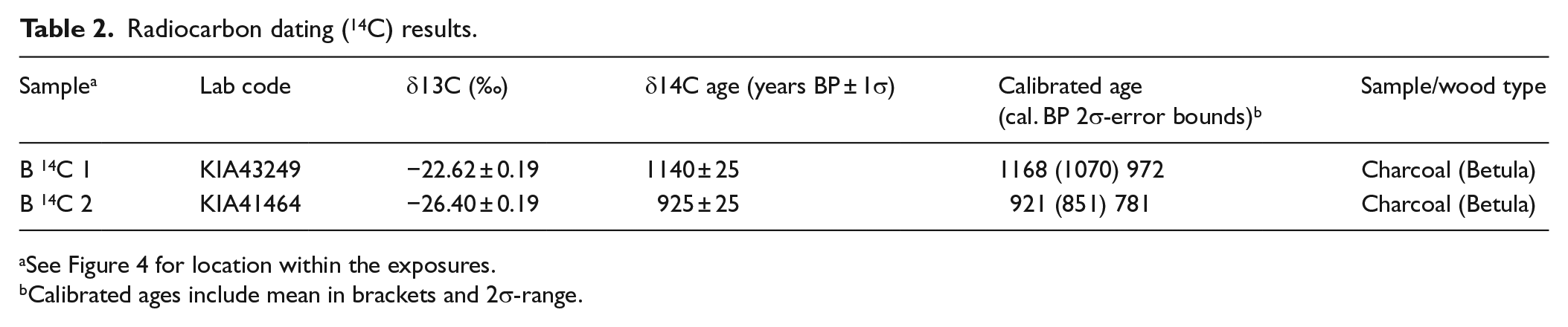
See Figure 4 for location within the exposures.
Calibrated ages include mean in brackets and 2σ-range.
Dating of ceramic fragments by typological sequence
Where ceramic pieces were found in the sediments, a maximum sedimentation age was established in the form of the relative dating by typological sequence (Forde-Johnston, 1974). Therefore, the size, proportions, material, decoration of the ceramics were analysed for Medieval and early modern times ceramic typology from the Institute of Archaeology at Kiel University.
Geostatistical estimation of slope deposit volume
Colluvial sediment thickness on the hillslopes and chronological data were integrated into an ArcGIS database. An airborne lidar-derived digital elevation model (DEM) with raster resolution of 1 m was used to establish the elevation of the coring sites, and to delineate flow directions, terrain parameters and the catchment boundary.
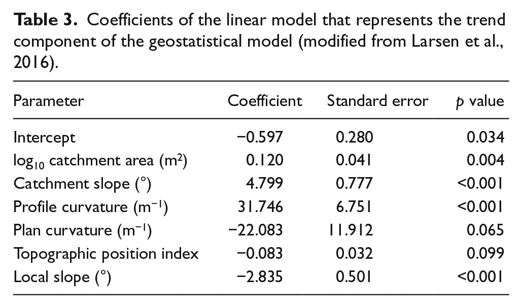
The volume of the top colluvial layer on the hillslopes was estimated by spatially modelling its thickness using kriging with external drift, a geostatistical technique that has been applied previously to predictive soil mapping (Scull et al., 2003; Webster and Burgess, 1980). We used the colluvial thickness measured in 183 cores and excavations (Figure 3), and as covariates local slope, plan and profile curvature, local catchment area, catchment slope and the topographic position index (Table 3). Further details of the model are given by Larsen et al. (2016). The statistical model was validated using leave-one-out cross-validation, and an error of 0.233 m was propagated into the volume calculation. The total volume of the colluvial layer was estimated by multiplying the modelled thickness on each raster cell (m) with its planimetric area, and summing these values for the hillslope subareas.

Predicted thickness of the Holocene colluvial layer in the Kirschgraben catchment, modified from Larsen et al. (2016). Pins show coring locations (n = 183), and colour indicates estimated thickness of colluvial deposition based on the employed regression model (Larsen et al., 2016).
Coefficients of the linear model that represents the trend component of the geostatistical model (modified from Larsen et al., 2016).
Calculation of sediment mass, flux, erosion and lowering rates
In order to quantify the total hillslope sediment mass (M, kg) for each land-use type we used
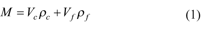
where V is the sediment volume as estimated using the geostatistical model (section 3.6) and ρ is the bulk density of the sediment (g cm−3). The subscripts c and f stand for the separation of the volume and density estimates into coarse and fine sediment components, respectively (Table 4). The error for M is estimated by propagating the SEs of the measurements.
Hillslope sediment flux. Volume (V) of coarse and fine sediments; bulk density (ρ) of coarse (1) and fine (2) sediment; mass (m) of coarse and fine sediment, and total mass (m total).

Location see Figure 1a; all number rounded to the nearest full number.
In the calculations of rates, all measurements (area, field measurements) were assigned a 10% measurement error, and we estimated the time period of interest (∆t) as constrained by the chrono-stratigraphic results (Figure 4). To approximate the time length of each deposit (so as to provide a long-term rates), we used the outer error margins of the ages closest to the top and the bottom of each deposit (Figure 4). This will most likely lead to an overestimation of the length period and subsequently underestimation of accumulation and lower the deposition rates. Hence these estimates are conservative, but with smaller error ranges. Errors were estimated by propagating the SEs of all measurements.
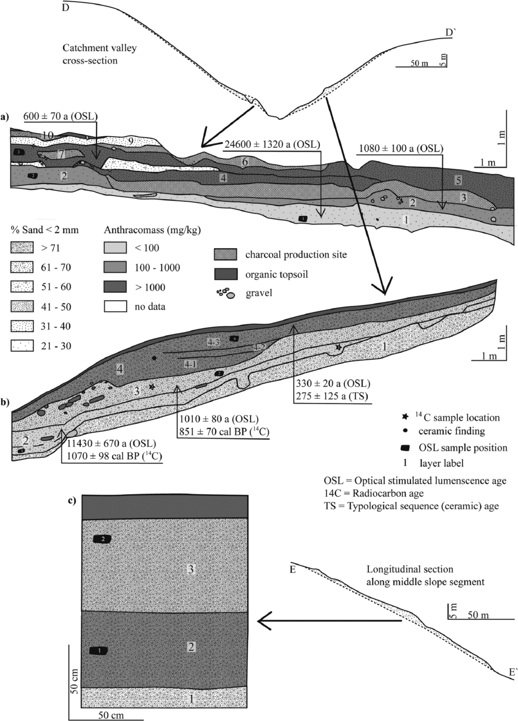
Exposures of hillslope sediments (a, b, c). Shading indicates Anthracomass. Longitudinal and valley cross-sections extracted from the digital terrain model. Locations of exposures are shown in Figure 1.
Using the deposition or accumulation rates of sediment to infer upslope erosion naturally results in some ambiguity given the same or similar data is used in all calculations, yet many different terms are used in the literature (Parsons, 2011). In order to avoid confusion around the term erosion rate (Parsons, 2011), and because we infer erosion from deposition rates, instead of using the more common erosion rate to describe the division of mass by time and area, we term this the sediment redistribution rate to better describe the inferred processes. We first use the chrono-stratigraphical results to estimate the accumulation rate (AR) as
Results
Chrono-stratigraphy
Three excavation sites were utilised for charcoal and sediment sampling, and for aiding the construction of the geostatistical model. The excavation sites incorporate a range of slope positions (lower and middle slope segments). Their interpreted stratigraphic layers are shown in Figure 4, with sites a, b and c located where the colluvial layer reaches its largest thickness on the slope. This comparatively large thickness is manifested as pronounced steps in the modern surface (sections D-D′, E-E′ in Figure 1). The age, sand content and anthracomass of all stratigraphic sections are given in Table 5. The basal hillslope sediments are a distinct, weathered sandstone layer (layer 1 in Figure 4b and c of unknown age). In Figure 4a and b, a dense, cryoturbated silty sediment was deposited on top, or remobilised between 24600 ± 1320 a (layer 1 in Figure 4a) and 11430 ± 670 a (layer 2 in Figure 4b). The cryoturbation of these layers makes it clear that the Medieval age (1070 ± 98 cal. BP, layer 2 in Figure 4b) must be erroneous, and is most likely a result of bioturbation. The charcoal content of these deposits is dominated by Betula and Quercus (Figure 5), and its sand content is low when compared with the superimposed layers (24% in a, 84.5% in c). Immediately above this deposit, a colluvial sediment can be found, homogenous in colour, gravel content (95% fine grained, 5% coarse grained) and bulk density (1.38 g cm−3 ± 0.02; n = 9). The onset of deposition was found to be somewhat synchronous within the Medieval period, at around 987 ± 158 years ago (pooled mean age calculated from 1080 ± 100 a in Figure 4a, 1010 ± 80 a and 851 ± 70 cal. BP in Figure 4b, 1005 ± 60 a in Figure 4c). The lower Medieval deposits within all excavation sites are characterised by a slight increase of anthracomass (344 mg kg−1in a (one order of magnitude), 94 mg kg−1 in b) (Table 5) and sand content (28% in a, 88% in c) in comparison with the underlying sediments.
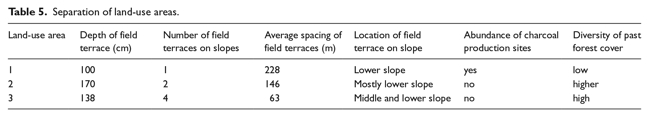
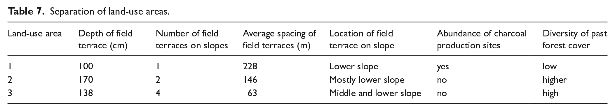
Separation of land-use areas.

Percentage of weight per analysed wood species from the charcoal fragments determined. The labels refer to Figure 2.
In the Medieval and post-Medieval deposits, sediment characteristics vary. The largest difference between the anthracomass of pre-Medieval deposits, Medieval and post-Medieval deposits can be seen at site a. This site exhibits well-defined layers almost entirely composed of charcoal fragments (up to 5 cm in diameter) and ash in between colluvial layers, which we interpret to be residuals of old charcoal production or kiln sites. These deposits are partially dug into the underlying colluvial layers; this might be the reason for the comparably low accumulation rate of 1.2 mm yr−1 at this site (Table 6). Anthracomass values of colluvial deposits (layers 4, 5, 6 in Figure 4a) increase by an order of magnitude (9375, 4428, 4974 mg kg−1; Table 5) between layer 1 (age: 24600 ± 1320 a) and layer 5 (age: 600 ± 70 a). These deposits, which have a comparably high charcoal content, are bracketed by two charcoal production sites (layer 3 and 8 in Figure 4) and intercalated with one charcoal production site (layer 7 in Figure 4a). The sand content stabilises during most of the younger colluvial deposition, but doubles in the uppermost deposit, layer 10 (Table 5), while anthracomass reduces by one order of magnitude to 950 mg kg−1. Site a is located at the lower end of the hillslope, just uphill from the steeper gully side walls, and therefore, the sediments form a step in the valley profile (E-E′). In contrast, site b is located further uphill away from the gully bottom, but also within a prominent step in the valley cross section (E-E′) (Figure 4). The excavation site b reveals that this step in the present surface was preceded by a pronounced step in the pre-Holocene surface. Large stones (>20 cm) located within the sediments and deposited with the long axis orientated parallel to the slope at the downhill side of the feature are unusual for the otherwise dominantly fine grained deposits. The otherwise homogenous sediment has an estimated accumulation rate of 1.5 mm yr−1 (Table 6), and shows no visible evidence for erosion or soil development. The anthracomass values at site b halve from 94 mg kg−1 within the initial Medieval deposition to 44 mg kg−1, but then increase and reach 102 mg kg−1 in the youngest sediments, deposited 330 ± 20 years ago (Table 5). The sand content steadily increases from 67% at the bottom to 82% in the top deposits. There are many tile and ceramic fragments in layers 3–4 of site b, but only one ceramic fragment could be dated to 275 ± 125 years ago, which is in broad agreement with the OSL date from the same deposit of 330 ± 20 a within the error ranges. We use the latter to calculate the accumulation rate of 1.5 mm yr−1 for site b, as the ceramic fragment might give an erroneous age as it might have been artificially introduced by humans when manuring fields with household garbage, a common practice in (pre)historic agriculture. Site c is located within the sediments of the largest step of many within the surface of area 3 (Figure 4c). The younger deposits (layer 2 and 3) are very homogenous in colour and sediment composition. The already high sand content in the older, periglacial layer (84.5%) perpetuates into the younger, post-Medieval layers (88%). However, anthracomass values show a significant decrease of one order of magnitude between the onset of colluvial deposition in Medieval Times (614 mg kg−1) to 45 mg kg−1 in the top layer, which is 520 ± 30 years in age. The accumulation rate here is the highest from within the three sites at 2.3 mm yr−1 (Table 6).
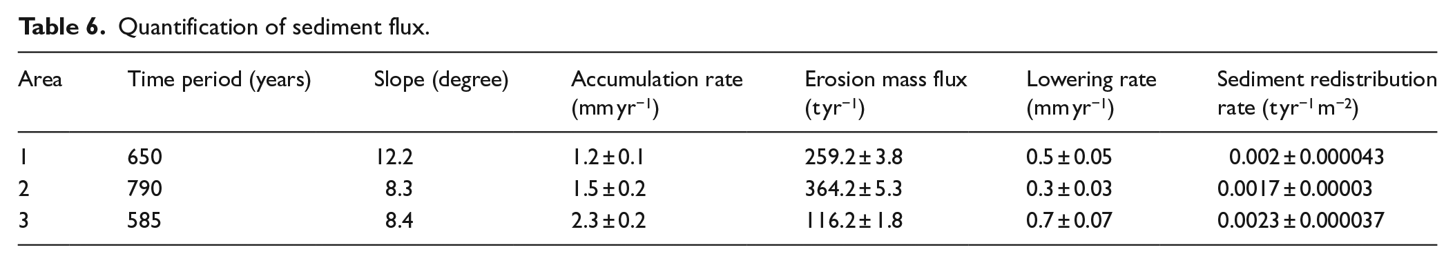
Quantification of sediment flux.
Wood species analysis from charcoal fragments
In the sediment sequence a, a clear dominance of the pioneer forest tree species Betula can be observed in all layers, accompanied mostly by other pioneer species. This high component of pioneer wood species (mostly Betula and Alnus) (Figure 5) is accompanied by a low diversity (Figure 6). Layer 1 (Figure 4a) is the most diverse in this exposure with Salix/Populus (3%) and Pinus (4%) besides the dominating Betula (65%) fragments (Figure 5). Layers 2–8 of site a are exclusively composed of Betula and Alnus. In layer 10, a 5% content of Carpinus, a late successional wood species, accompanies the pioneer wood species Betula (95%) (Figure 5). The taxonomical analysis of the sediment sequence b displays a much more diverse forest (Figure 6). Layer 2 (11,430 ± 670 a) shows a composition of half Betula and half Quercus, the latter being a wood species that represents a more natural forest and is only very rarely found in the KGC sediments examined here (Figure 5). This composition changes dramatically in layer 3 (1010 ± 80 a): The number of wood species increases, and while the late successional forest tree species Quercus and Carpinus occupy only a minor percentage, the pioneer wood species Betula and especially Alnus dominate (Figure 5). In layer 4, ~330 a of age, which was divided into three sublayers (4_1, 4_2, 4_3), wood species composition shows an increasing diversity with decreasing depth and with it an increase in late successional wood species: Betula decreases from 94% to only 6%, and late successional forest tree species, such as Carpinus, Fagus and Quercus, increase as well as the diversity of pioneer species (Figures 5 and 6). Layer 4_3 presents a trend towards a reduction of Betula and an increase of other pioneer tree species as well as late successional tree species is clearly visible (Figure 6). Sequence c displays the highest diversity of wood species found in this study (Figure 6), and also has a relative high content of late successional forest species, some of which were not present in the sediments of site a and b (Fagus, Fraxinus, Ulmus) (Figure 5). Notable is the relatively high component of Prunus in both layers, which in the region might represent (1) cultivated plants for fruit production or (2) wild bushes and small trees (most common: Prunus spinoa, Prunus avium spp), common on the side of agricultural fields or grassland.
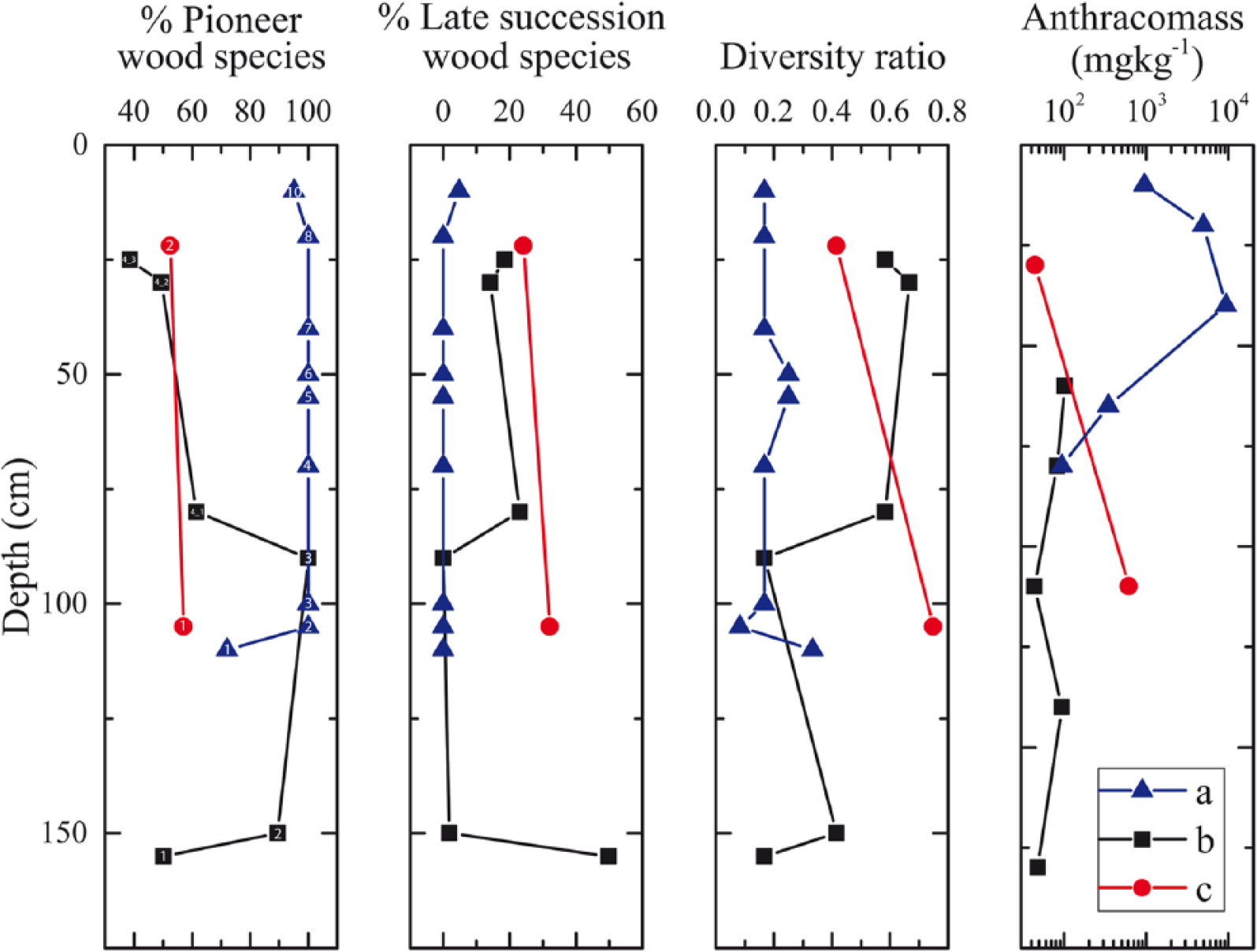
Properties of excavation sites: (a) pioneer wood species (%) (from wood charcoal analysis), (b) late successional wood species (%) (from wood charcoal analysis), (c) diversity ratio (from wood charcoal analysis) and (d) Anthracomass (mg kg−1). Numbers refer to layers in Figure 4.
Separation of the catchment into three areas of different land-use types
On the basis of results from sections ‘Chrono-stratigraphy’ and ‘Wood species analysis from charcoal fragments’ and visual analysis of the DEM, the catchment hillslopes were divided into three areas (land-use areas 1, 2, 3) in which different types of land-use techniques were applied since Medieval settlement of the region. This separation can only be an approximate estimation of the borders because of the natural spatial variability in sediment deposition thickness. Land-use techniques were specified on the basis of (1) character, height and spacing of field terraces; (2) the abundance and shape of charcoal production sites; and (3) characterisation of forest cover from wood charcoal analysis (see Table 7 for specification). Land-use area 2 was defined by the dominance of one large agricultural field terrace mostly located on the lower and middle slope segments. Land-use area 3 has a high density of large agricultural field terraces. Both have low anthracomass values, and a relatively high diversity in their charcoal record (Table 7). In contrast, land-use area 1 has a comparatively small, single field terrace, and shows an alternating deposition of pure charcoal layers and sedimentary, colluvial layers within it. The charcoal record indicates a low diversity forest. This separation can only display a rough spatial estimation of the extent of the different land-use types as it was partially derived from three excavation sites on the lower slope segments in combination with topographical features. However, we are confident that the comparatively large size of the separate land-use areas (up to 32 m), complemented with 183 corings, provides a realistic insight into the sedimentary patterns of the research area. The time period for the duration of specific land-use types can also only be considered a rough estimate, since they are derived from Radiocarbon and OSL techniques which have large error ranges. At all sites, we were not able to date the very top (30 cm) and the very bottom of the sedimentary sequence (10–30 cm) because of evidence for increased bioturbation in these locations.
Separation of land-use areas.
Quantification of mobilised hillslope sediment
The colluvial layer corresponding to the youngest, continuous phase of hillslope deposition can be found throughout the entire catchment and dates to between 1080 ± 80 a and 330 ± 20 a (Figure 4). This widespread colluvial layer could be accurately identified by its stratigraphic position, homogenous colour and nearly constant bulk density (on average 1.38 g/cm3 ± 0.02; n = 9; (Larsen et al., 2016). In this study, we use the same model as Larsen et al. (2016) to estimate the spatially distributed thickness of the colluvial layer, and summarise the result for each subarea. Generally, the model coefficients (Table 3) highlight the importance of terrain attributes in influencing the formation, deposition and preservation of hillslope deposits; larger and steeper contributing areas, for example, are associated with larger sediment thickness, while the colluvial layer tends to be thinner for higher TPI (indicating upslope positions) and for steeper slope segments (Larsen et al., 2016). Here, we calculate the sediment volume for area 1 as 34,311 ± 478 m3, area 2 as 49,467 ± 611 m3 and area 3 as 21,698 ± 301 m3 (±one σ). Using Eq. 1, these results were then converted into mass (area 1: 168479 ± 2501 t, area 2: 287684 ± 4204 t, and area 3: 67957 ± 1063 t) (Table 4), loss of sediment per year (259 ± 3.8, 364 ± 5.3, 116 ± 1.8 t yr−1), lowering (0.5 ± 0.05, 0.3 ±0.03, 0.7 ±0.07 mm yr−1) and sediment redistribution rates (0.002 ± 0.000043, 0.0017 ± 0.00003, 0.0023 ± 0.000037 t yr−1 m−2) (Table 6).
Discussion
Pre-medieval forest composition
Pre-Medieval sediments have very low Anthracomass values (<100 mg/kg) (Figure 4a layer 1 and 4 b layer 2). This is because natural fire events from lightning and/or extreme droughts (for central European conditions) were rare, and most likely only very localised. Hence, the charcoal that is preserved does not necessarily reflect the complete forest composition, but is biased towards which individual trees were burnt. Despite this, the plant diversity in the charcoal record is comparatively high (Figure 6), as expected from a natural or near natural forest. Charcoal assemblages from these layers are dominated by Betula, a pioneer forest tree species, as well as Pinus and Salix/Populus, with minor occurrences of Quercus and Carpinus (Figure 5). We hypothesise here that the total absence of Fagus in the charcoal record of these layers might be because of pre-Medieval human impact through the introduction of animal grazing in the forest, a widespread land-use in central Europe during prehistoric times (Gaillard et al., 2009; Kalis et al., 2003). The repeated disturbance of the forest succession by the animal grazing induces a limitation of the forest dynamic to early forested successional stages (Feurdean, 2005), which do not permit the local establishment of Fagus which is a late successional forest tree (Bradshaw et al., 2015). This hypothesis is supported by the presence of Betula and Carpinus, which are typical wood species for animal grazed forests, because they are favoured by animals, produce comparatively large amount of fodder at a low height and are not very sensitive to animal bites (Walentowski, 2001). Quercus is mostly spared by animals, and is therefore a typical wood species for grazed forests (Bradshaw et al., 2015; Kalis et al., 2003), and also deliberately favoured by people because of its nuts, a nutritious fodder for domestic pigs. However, the interpretation of the pre-Medieval forest composition could be influenced to some degree by bioturbation in the sedimentary record and the migration of charcoal fragments into the lower layers, as suggested by the erroneous age in layer 1 of site A. In any case, the vegetation cover must have been sufficient to promote widespread slope stability such that no large colluvial layers developed in the pre-Medieval period of the Holocene, and therefore no widespread soil degradation occurred from earlier land-use. This is not to say that hillslopes were inactive, since it has been shown that soil can also be transported downhill by bioturbation and creep under vegetated conditions (Hughes et al., 2009; Roering et al., 2002), or small-scale agricultural practices. However, the one order of magnitude increase in agricultural soil erosion rates in the late Holocene (Montgomery, 2007) is likely to obscure any record of soil erosion because of these other processes, and therefore cannot be determined in this study.
Medieval and early modern times cultivation
Timing of cultivation initiation and cessation, and their causes
The homogenous ages throughout the youngest hillslope sedimentary layer mark a time period of one continuous phase of colluvial deposition, ranging between ~1005 ± 60 a and ~330 ± 20 a (Figure 7). Given the evidence for relatively stable and vegetated hillslopes throughout most of the Holocene (section ‘Medieval and early modern times cultivation’), these layers must originate from the relatively synchronous clearing of catchment vegetation for agricultural use, and the subsequent occurrence of sheet erosion on a regular basis. The onset of intensive settlement and land-clearing activity at around ~1100 years ago matches the broader historical evidence for Medieval settlement activity in the mountainous area of central Europe (Denzer, 1996), and the onset of higher hillslope erosion rates (e.g. but not limited to Dotterweich, 2005; Lang, 2003; Rommens et al., 2005). However, causes for the cessation of cultivation within most of the KGC at about 330 years ago are less clear, and have several potential candidates: (1) climate deterioration during the ‘Little Ice Age’ (Glaser, 2013; Mann et al., 2009). Agriculture in KGC is likely to be sensitive to climate deterioration because a prolongation of snow cover within the course of a year would have the potential to make agriculture unsustainable. (2) Thirty Years war (AD 1618–1648), a phase of socio-economic destabilisation, must also be considered to have caused a reduction in population density and with it the abandonment of land. It is known from a written source from AD 1633 (382 years ago) that only 27 families lived in the adjacent village Heimbuchenthal, and was strongly economically affected by the Swedish occupation of the village, especially because all men had to join the corps which was likely to reduce working power on the fields (Bachmann, 1982). During the same time period, an outbreak of the Plague is reported from central Europe, but has not been reported from the area at that time (Bachmann, 1982), and is therefore less likely to have caused land abandonment; and (3) soil degradation and exhaustion caused by unsustainable land-use techniques in Medieval Times (Bork, 1988). However, land-use is patchy in landscapes, and soil exhaustion depends on antecedent conditions. The latter, soil erosion and degradation in combination with land-use techniques will be further examined in the following sections.
Types of land-use
Crop rotation (field–grazing–forest; ‘birch silviculture’) (land-use area 1)
Area 1 exhibits the smallest field terrace developed in the catchment and the lowest accumulation rate in the catchment. It is clearly distinct from areas 2 and 3 through the alternation between colluvial sediments and charcoal layers, the first indicating sheet erosion and agricultural land-use, and the charcoal production sites suggesting forestry was the dominant land-use. It is well known that charcoal producers did not transport the wood they burnt, but rather constructed the kiln locally within the area they deforested (Ludemann, 2010); therefore, agriculture and forestry must have been practised successively on the same fields. Chronological evidence suggests that this alternation in land-use techniques was practised between ~1080 and 600 a. Also, charcoal burners usually did not prefer distinct wood species over others for burning (Ludemann, 2010; Nelle, 2003), and so it is likely that the charcoal record (Figure 5) displays a reliable source for past forest composition within the caveats of the method. This means that the forest in area 1 was mainly dominated by Betula and Alnus and would have been of low diversity throughout the repeated periods of reforestation (Figures 5 and 6). Considering all the evidence, it is likely that the alternating stratigraphy represents a type of crop rotation cultivation technique (‘birch silviculture’) which is described as ‘Birkenberge’ in the Bavarian Forest, ~300 km south west of the research area, but only during modern times (Oberdorfer and Reich, 1990; Walentowski, 2001): after the initial clearing of the forest, the surface was burnt to enrich the soil with nutrients and to clear the surface to facilitate the cultivation of field crops (Figures 8 and 9). These fields are reported to have been highly productive for the early years of crop cultivation, but then decreased quickly (Walentowski, 2001). Hence, fields were subsequently used for grass and/or hay production after productivity decreased (Figure 9). Pioneer tree species Betula and Alnus (where Birch trees are the dominant pioneer species) were then encouraged to grow by limiting the grazing of animals and/or even by spreading of Betula or Alnus seeds (Figures 5 and 9). After ~20 years, trees were harvested, probably in the form of coppicing (Nelle, 2003), burnt for charcoal production, and finally a new cultivation cycle began (Figure 9). To our knowledge, this represents the earliest evidence for this specific cultivation technique in central Europe. We therefore argue that birch silviculture was a more common cultivation technique in the Medieval central European mountains than previously thought. This is supported by the fact that new cultivation techniques (e.g. three-field crop rotation) were popular at around the same time as birch silviculture in the research area was established (~1100 years ago). It has been shown by previous studies that early modern birch silviculture fundamentally altered the forest composition for hundreds of years and still influences the tree composition of modern forests (Oberdorfer and Reich, 1990). This finding is likely to be also true for the research area, as several forest patches of area 1 are still dominated by birch.
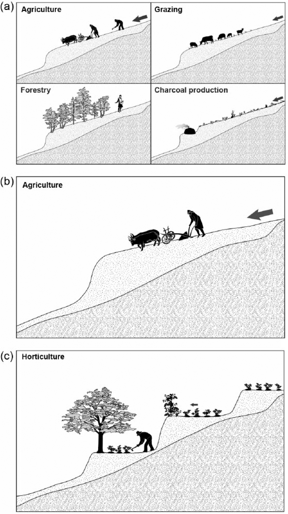
Land-use types practised in areas 1, 2 and 3. (a) a regional type crop rotation, alternating forestry–agriculture–pasture; (b) conventional agriculture using a plough on large fields; and (c) horticulture with smaller field sizes.
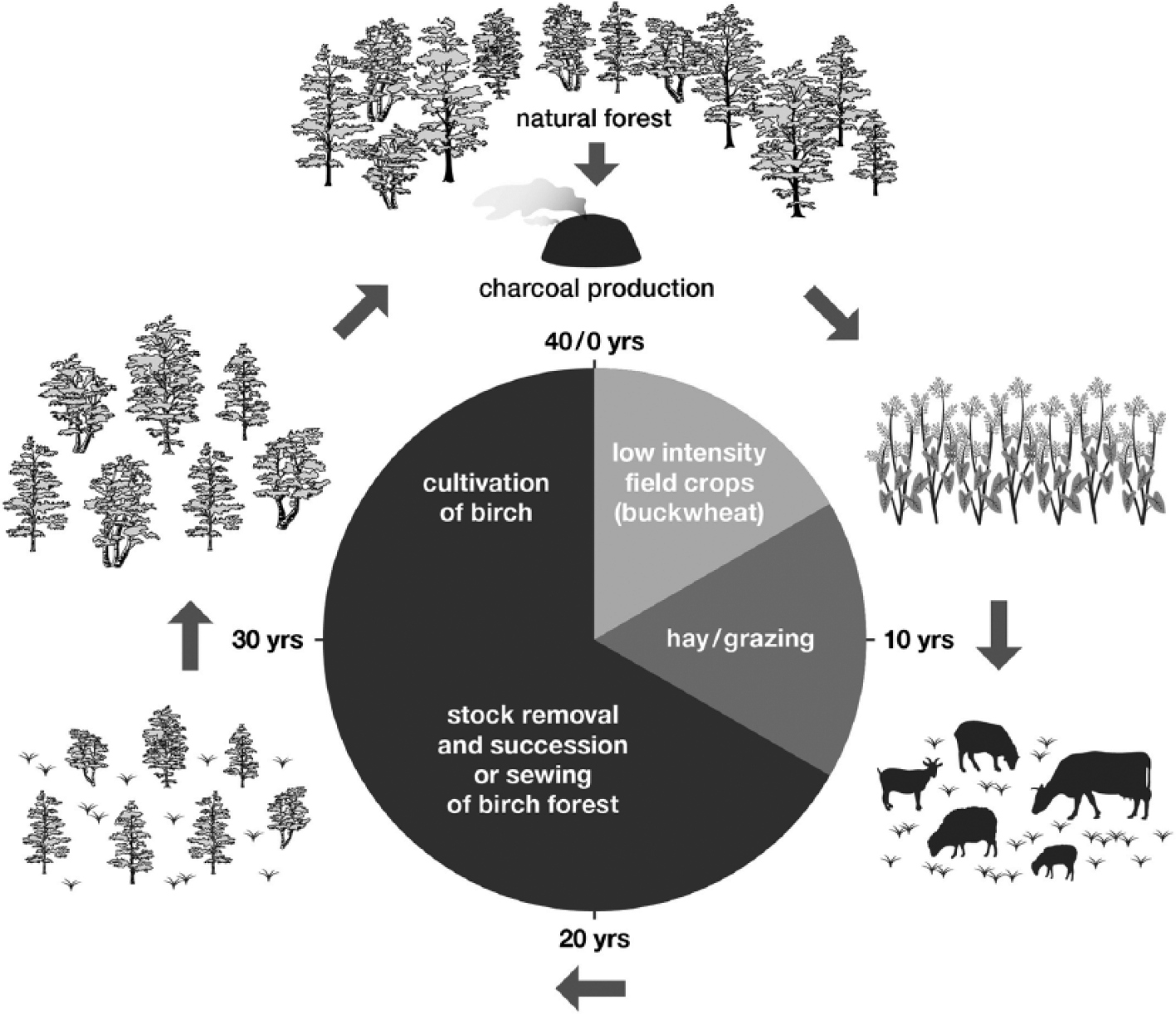
Conceptual model of the regional rotational cultivation technique ‘Birch silviculture’ (modified from Walentowski (2001)). After deforestation, crops were cultivated on initially fertile soils. After ~10 years, the soils were exhausted, and fields were used for grazing. After ~20 years, stock was removed and pioneer wood species were either sewed or naturally succeeding. The birches were coppiced, and allowed to grow for ~20 years. When large enough, charcoal was produced from the coppiced birches, soils had partially re-gained their fertility and were manured with ash and some charcoal from kiln sites, and again cultivated by growing undemanding crops, typically buckwheat. Most likely, the rootstocks of the birches remained in the ground, and buckwheat was sowed around them using a rake. The rootstocks would later serve as additional food for the stock, and were then re-activated when stock was removed. This type of shifting cultivation was reported from modern times from the Bavarian Forest ~300 km SE of the research area, and was very likely to have been a widespread cultivation technique within the mountainous area in central Europe (Oberdorfer and Reich, 1990; Walentowski, 2001).
Cropping agriculture (land-use area 2)
Area 2 is characterised by the dominance of one large field terrace located at the lower–middle slope segments, and the absence of charcoal production sites. The occurrence of one main, steadily aggrading field terrace indicates comparably large hillslope field sizes throughout the ~700 years of cultivation (Figure 4). We assume that these large fields were used for crop production, for which the originally silty soils would have been suitable. In Medieval times until well into early modern times, rye (Secale cereale) was the dominant crop, but millet (Panicum miliaceum) was also a widely produced crop. Fragments of both plants were found within Medieval latrine sediments in the moat of a small castle located on the fan of the gully catchment (Dannath et al., 2013), indicating they may have indeed been harvested within the research area. The anthracomass within of the Medieval layers of site b (Figure 8b) increases only slightly, indicating low burning activity, which also supports the interpretation of a traditional cropping agricultural land-use (Figure 8b) with large field sizes for this area. The high diversity of wood species found in the charcoal record might represent the occasional burning of trees and shrubs growing on field borders, a technique explained in detail in the next section.
Horticulture (land-use area 3)
Area 3 is located immediately within or adjacent to the hamlet Heimathenhof (Figure 1) and is characterised by a high density of field terraces (Table 7), which we interpret to be the product of smaller field sizes, typical for horticulture including the cultivation of labour intensive crops such as potatoes in the region (Figure 8c). The comparably sandy soils would have made human work easier, and the low water retention in the soils could be easily compensated for by watering plants using the nearby well located within the settlement. Anthracomass values increased throughout the period of human activity to one order of magnitude higher than the background values of the pre-Medieval sediments found in sites a and b. However, they are still much lower than the colluvial layers directly influenced by charcoal production sites within site a. The observed increase in charcoal fragments at the onset of colluvial deposition could be because of the burning of branches and rootstocks following the initial clearing of the forest. In the overlying layers, charcoal is likely to originate from the occasional burning of shrubs and small trees growing naturally on field borders, which is widely practised by the present population in the region, and would also explain the high diversity in the charcoal record. This is done to reduce shade effects on the fields, but also to fertilise the soil with charcoal and produce wood/charcoal for heating and cooking. The relatively equal distribution of the charcoal in the soil profile can be explained by turning the soil in the field during spring and/or during planting. Charcoal fragments of the species Prunus likely indicate either the intentional cultivation of fruit trees, typical for Medieval times and supports horticulture being the main land-use in area 3 (Dannath et al., 2013), or the existence of agriculture and managed grassland.
Land-use techniques increase hillslope sediment storage capacity
Hillslopes are the largest storage area of the human induced sediment flux in the KGC (Larsen et al., 2016), and throughout the Rhine catchment (Hoffmann et al., 2013). Based on earlier work, the Holocene colluvial hillslope deposits amount to ~88% of the mobilised sediment, while only 12% of the hillslope sediment has been transported into the gully bottom and/or further downstream (Larsen et al., 2016). Late Holocene colluvial sediments in the KGC are distributed in variable thickness on all hillslopes, generally following a trend of thickening with distance downslope (Figure 3). This pronounced increase of sediment deposition in the downslope sections coincides with the location of agricultural field terraces, which are known to enhance sediment deposition mainly by shortening slope length (Tarolli et al., 2014). Importantly, and in contrast to similar landforms described in mountainous contexts (Sofia et al., 2014; Tarolli et al., 2014), the field terraces in the study area develop at abrupt changes in slope over time, and were initially caused by (1) parallel tilling, which overturns the soil that aggrades over time and develops a less inclined slope segment at the lowest topographical field border (Bork, 2006), where transport energy decreases and hence sediment is deposited (Nyssen et al., 2014). Over time, this feedback traps a substantial amount of sediment, and forms a pronounced step on the hillslope (Nyssen et al., 2014), which we term agricultural field terrace. Their evolution is probably similar to lynchets in Ethiopia (Nyssen et al., 2014), and strip lynchets on the British Isles (Macnab, 1965), which are also mainly of Medieval origin; however, the field terraces described here show no signs in the stratigraphic record for intentional construction. The potential to trap eroded hillslope sediments was also likely intensified by (2) the presence of gravel piles, which developed through manual removal of stones from the fields and their replacement at the field borders, which is evident within the sediments of site b (Figure 4). This is known to have been common practice since large gravels have hindered agricultural practices of the time (Keller, 1856). The thickest field terraces with the highest sediment redistribution rate in the catchment (0.0023 t yr−1 m−2) was found in area 3 (Figure 6). However, this is only slightly higher than the sediment redistribution rates of areas 1 and 2 (Table 6) and is most likely because of the higher density of field terraces and therefore a higher overall hillslope storage capacity.
In this study, it is clear that different types of land-use techniques seem to have had surprisingly little influence on Holocene erosion rates in the KGC. The small variability in sediment redistribution rates (Table 6) and the counterintuitive finding that the area with the largest field sizes and cropping agriculture has the lowest sediment redistribution rates (land-use area 2) and the area with small field sizes and more sustainable land-use (horticulture) has the highest sediment redistribution rates (land-use area 3) indicate instead that hillslope storage capacity is the primary driver of hillslope sediment flux and sediment export downstream. In other words, the connectivity between hillslope and downstream sediment flux once vegetation is removed is dependent on the sediment storage available on the hillslopes, and this storage capacity is controlled to some extent by the land-use techniques used. While this is in general not a new finding, it is important in the context of studies of (pre)historic sediment flux, as the abundance of field terraces might explain variations found in lake or floodplain sediment deposition rates. In addition, it highlights the need to consider hillslope sediment storage as the main link between human land-use and erosion rates, rather than assuming these measures should scale directly. With the increase of widespread high-resolution surface data, studies on past sediment flux could easily include catchment hillslope storage features in order to better understand variations in downstream sediment flux.
Conclusion
This study tested whether variable land-use techniques have an influence on long-term hillslopes soil erosion and sediment redistribution. Land-uses were (1) a type of rotational silviculture (‘Birch silviculture’), for which this study finds the earliest evidence; (2) conventional cropping agriculture using a plough on large fields; and (3) horticulture with smaller field sizes. We find that sediment redistribution rates increase after initial deforestation ~1100 years ago, and remain high until reforestation ~300 years ago. Differences in hillslope long-term sediment flux from changing land-use techniques are largely masked by an increase in hillslope sediment storage through land-use practices creating agricultural field terraces, which are widespread in central Europe, and should be considered in studies reconstructing past sediment flux. This study however does demonstrate that it is possible to reconstruct spatially variable past land-use techniques through the combination of soil charcoal analysis (Anthracology) and the geomorphic context of the deposits in which they are contained, and then quantify the human influence on sediment redistribution through a geospatial model.
Footnotes
Funding
This research was undertaken at the Human Development in Landscapes graduate school at Kiel University, funded by the German Research Foundation (DFG). We appreciate the support of the local council of Heimbuchenthal and the cooperation with the Archaeological Spessart Group (ASP).We thank Dr Annika Mertens for analysing ceramic fragments, and two anonymous reviewers for their comments, which greatly improved the manuscript.