



Abstract
Records of occupation by humans in the period following shortly after the Last Glacial Maximum (LGM; 21 ± 2 kyr cal. BP) are still very rare in Central Europe, since it is inferred that the extreme climatic conditions caused the decolonisation of previously settled areas. Our study focuses on the reconstruction of environmental conditions in the surroundings of the open-air Palaeolithic site, Brno-Štýřice III, which falls within this period. The research concentrated on the study of malacological, pollen and anthracological samples to reconstruct the climate shortly after the LGM. 14C dating places the chronostratigraphic position of the site more precisely at the end of the LGM, more specifically into Last Glacial Termination (LGT); analysis of chipped stone industry identifies the occupation with the Epigravettian settlement. The site represents a significant example of the recurrent habitation of a microclimatically favourable microregion near a watercourse in order to utilise available sources of livelihood. The results of the pollen, anthracological and malacological analyses documented a more or less treeless character of surrounding landscape. The vegetation was mostly formed by a mixture of shrub tundra and grassy loess steppe vegetation. Open woodland with birch, willow and bird cherry occurred in relatively moist river banks and the lower slopes of hills with more favourable microclimatic conditions. Malacological collection highlights the presence of cool temperate species (Pupilla loessica, Vallonia excentrica and Helicopsis striata). In the surroundings of the studied site, the pollen analysis provided a reconstruction of parkland forest-steppe vegetation (with lack of temperate deciduous trees) typical for a cold and dry climate. Development of both dry and moist stands near the watercourse was recorded. Anthracological analysis is in support of similar outcomes, reconstructing the presence of open woodland with dominating birch and willow in the nearby surroundings.
Introduction
The period of the so-called Last Glacial Maximum (LGM), which is part of the Late Pleniglacial (e.g. Magyari et al., 2014a, 2014b), is defined on the basis of the regression of sea level (Yokoyama et al., 2000) or the related maximum extent of glacier ice (Clark et al., 2009; Ehlers et al., 2013), which occurred between 26.5 and 20/19.0 kyr cal. BP. At the same time, the LGM period is generally considered to be climatically extreme, conditions in which the hitherto known Palaeolithic settlements retreat from exposed areas into preferential (more sheltered) refuges. In Germany, for instance, this period is usually described as the time of resettlement of the original occupied areas that became re-colonised only with the onset of the Magdalenian permeating from France (Terberger, 2013; Terberger and Street, 2002). Similarly, the reduction in the number of significant sites has also been noted in Moravia in the past (Oliva, 2005; Svoboda et al., 2002; Valoch, 1996, 2010).
The climatic conditions considerably influenced Central, Western and Northern Europe during the highest phase of the Weichsel glaciation. The palaeoclimate in the Middle Danube region during the LGM is reconstructed as mean summer temperature of about 11°C with mild September (ca. 7°C). Winter began in November (−5°C), and in January and February, the temperature dropped down to −11°C to 12°C. The proposed mean annual precipitation peaked in July and August (3 mm/day), then it fell to its annual minimum of 1 mm/day in October, staying at an average 1–2 mm/day through winter (Davies et al., 2003). The Czech Republic and the adjacent territories were part of a relatively narrow (about 400 km wide) zone delimited by the front of the continental glacier in the north and by the Alps in the south (extent of glaciation, e.g. Ehlers et al., 2013).
The reconstruction of Late Pleniglacial vegetation has traditionally been based on interpreting pollen data. Many pollen records of the period of the Last Glacial in Central Europe show a shift in pollen from dry steppe/shrub tundra to a birch/juniper woodland followed by a birch/pine forest (e.g. Amann et al., 2013; Jankovská and Pokorný, 2008; Magyari et al. 2014a, 2014b; Willis et al., 2000). Nevertheless, palaeobotanical data from LGM sites in eastern-central Europe generally confirm the existence of not only parkland landscapes with coniferous trees (such as Pinus sylvestris, Pinus cembra, Larix, Picea and Juniperus) but also more demanding tree taxa (Abies, Corylus, Quercus, Fagus, Fraxinus, Ulmus, Taxus or Carpinus; see Jankovská and Pokorný, 2008; Willis and Van Andel, 2004). Taking into account new palaeobotanical and molluscs data, the local conditions in the whole area of the Czech Republic were more favourable (for more discussion, see Horsák et al., 2010; Jankovská and Pokorný, 2008; Juřičková et al., 2014; Ložek, 2001, 2009). The aim of this study is to present the new information about the local climatic conditions during the LGM/LGT period based on the results of excavation of a Palaeolithic site.
Archaeological background
From the archaeological point of view, the LGM period in Central Europe is characterised by the end of Gravettian in the so-called Kostenki-Willendorf phase (around 24–25 kyr cal. BP) and the onset of Magdalenian colonisation, which proceeded from Western Europe through the north German lowlands as far as Moravia, where it arrived in around 17–18 kyr cal. BP (Neruda, 2010; Ne-ruda et al., 2009). Despite the generally adopted awareness of the decolonisation of the climatically exposed regions of Central Europe in the LGM and the following period that preceded the Magdalenian colonisation, in recent years, we applied ourselves to the study of an archaeological site, the occupation of which falls within the period, when the LGM petered out, and the LGT that followed, on the grounds of 14C dating (Nerudová and Ne-ruda, 2015). The evidence of the local more favourable conditions can be documented not only by palaeorecords in vegetation but also by archaeological evidence. On the basis of the cultural classification or geomorphological position we can associate with the short period between the end of the Gravettian and before the onset of the Magdalenian in Moravia almost 49 sites. Contrary to the previous Gravettian, the re-analyses of the settlement dynamics revealed significant changes. On the basis of reconstruction of settlement strategy of the Epigravettian sites we can conclude that the majority of localities are situated within the interval of 200–250 m a.s.l.; the sites are mostly oriented towards the east through to north-east and are usually much closer to (mostly) small river in protected areas (Nerudová and Neruda, 2015).
Regional setting, site characteristics and stratigraphy
The excavation site Brno-Štýřice III (global positioning system (GPS): World Geodetic System 1984 (WGS-84): 49°11′2.5505″N, 16°35′41.6602″E; S-JTSK: 1161873.78, 599243.33 – the centre of the locality) is located in the south-western part of Brno, approximately 300 m to the south of the current bank of the Svratka River (Figure 1). Here, at an elevation of 210 m a.s.l. (10 m above the river level) is a step in the lower terrain which on the west side rises up into a low but steep cliff of Lower Devonian conglomerates known as Červený kopec (Red Hill) with a maximum height of 311.42 m a.s.l. The Quaternary cover of the region is formed by an accumulation of aeolian (loess) and colluvial sediments deposited on a terrace consisting of gravels with clay matrix and sandy gravels of Quaternary age, which were detected at a depth of 6–8 m. A coring revealed that the sequence of Pleistocene sediments at the locality is up to 10 m thick in places and is not divided by any distinct fossil soils. Towards the superposed layers, the sequence of loess and loess sediments is covered by an orange silty sediment C (weakly developed soil followed by Holocene stratigraphy brown earth; see Nerudová et al., 2012: Figure 2). Within the whole area under investigation, Holocene soil inclusive of the A- and B-horizons is only preserved in higher parts (i.e. at the W and SW edge of the excavated surface). In the central part of the slope, only a relic of the B-horizon is preserved, and in the NE and E parts of the investigated area (i.e. in the lowest parts), the B-horizon is not preserved at all. This being the reason why the A-horizon settled immediately on the Pleistocene sediments.
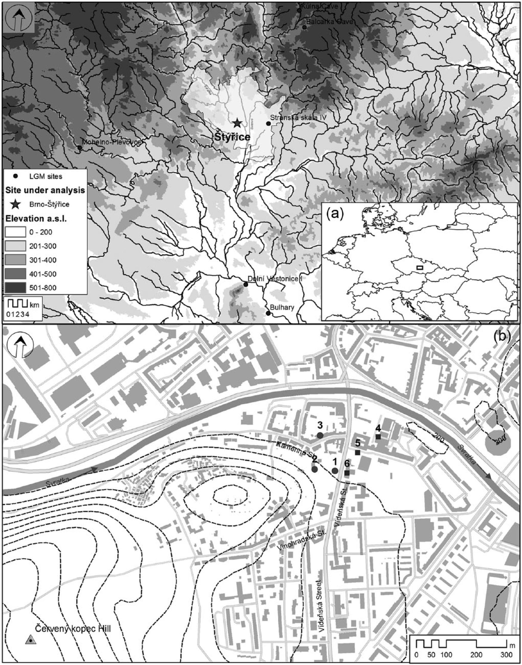
(a) Moravia region with LGM/LGT sites mentioned in the text and (b) microregion of the Brno-Štýřice with Palaeolithic finds.
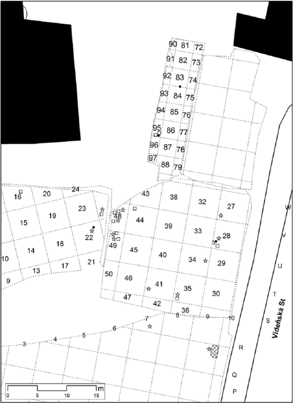
Detail plan of the Brno-Štýřice III site (excavations 2009–2014) and positions of taken samples for analyses.
The site of Brno-Štýřice III was first investigated by K Valoch; in 1972, he conducted small-scale rescue excavations there; nevertheless, the excavations yielded a representative collection of chipped stone industry as well as the remains of animal bones and blobs of ochre (Valoch, 1975). The assemblage was dated later on (Valoch, 1980, 1996; Verpoorte, 2004: 262); for more discussion, see Nerudová and Neruda (2014). The next large-scale rescue excavations were carried out in 2009 and 2011–2014. They revealed the extent of settlement, a new site (in 2009 – Štýřice IIIa), and yielded a large amount of lithics and osteological material.
Archaeological finds of the Palaeolithic age were found in the uppermost part of the Late Weichselian loess cover, which formed a 25-cm-thick (approximately) layer of orange-brown loess-like sediment (weakly developed soil). This layer was almost continuously present over the entire investigated area as it followed the inclination of the terrain, which was quite steep in certain places. There was a relatively sharp border between the horizon with archaeological finds and the underlying sediments. Although the lithic artefacts and bones were deposited in loess-like sediment, the base of the superposed chernozem horizon A sporadically intruded (e.g. the upper part of a mammoth jawbone; Nerudová et al., 2012). The first radiocarbon date was obtained from a charred bone of reindeer (Valoch, 1980, 1996), the next dating (performed by A Verpoorte in 2001 from the same sample; see Nerudová and Neruda, 2014: Table 4), yielded a date very similar to the previous one (Verpoorte, 2004). The evidence of human activities falling the site within the Epigravettian period (Nerudová, 2015; Valoch, 1975). Sampling during the last seasons of excavations provides us to perform the palaeobotanical analysis.
Materials and methods
The collection of samples
The collection of samples was carried out within the archaeological research of the site in 2009 and 2011–2014 (Figure 2; e.g. Nerudová and Neruda, 2014). We took samples of varying volumes: individual bigger charcoals (0.5–2 cm) macroscopically distinguishable in the course of preparation of the archaeological layer (all bigger samples taken during excavation were determined as fragments of burnt bones; Roblíčková et al., 2015) and target sediment samples of 5–10 L from the places with dispersed pieces of charcoal or bones. For the pollen analysis, we took samples of 0.5–1 L volume.
The extractions of the charcoal, molluscs and bones from the sediment samples were subjected to the standard flotation procedure using staggered sieves with a mesh size of 0.25 mm.
Radiocarbon dating
New radiocarbon dating was performed using the accelerator mass spectrometry (AMS) method in the laboratory in Oxford, where samples underwent standard laboratory procedure (Bronk Ramsey et al., 2004b). Animal bones (mammoth molars and mandible) coming from a distinct archaeological context served for the dating because of the volume required, since no other suitable material was available (the abundance and size of charcoals was very low, at the limit of the method; see Bronk Ramsey et al., 2004a). Before dating, the bones were not cleaned using chemical methods; they were only determined. The standard process in Oxlab is measurement of bone collagen by ultrafiltration method (Bronk Ramsey et al., 2004b). Isotopic fractionation has been corrected for using the measured 13C values measured on the AMS, the quoted 13C values are measured independently on a stable isotope mass spectrometer (see Bronk Ramsey et al., 2004a, 2004b).
Laboratory preparations and analysis of fossil samples
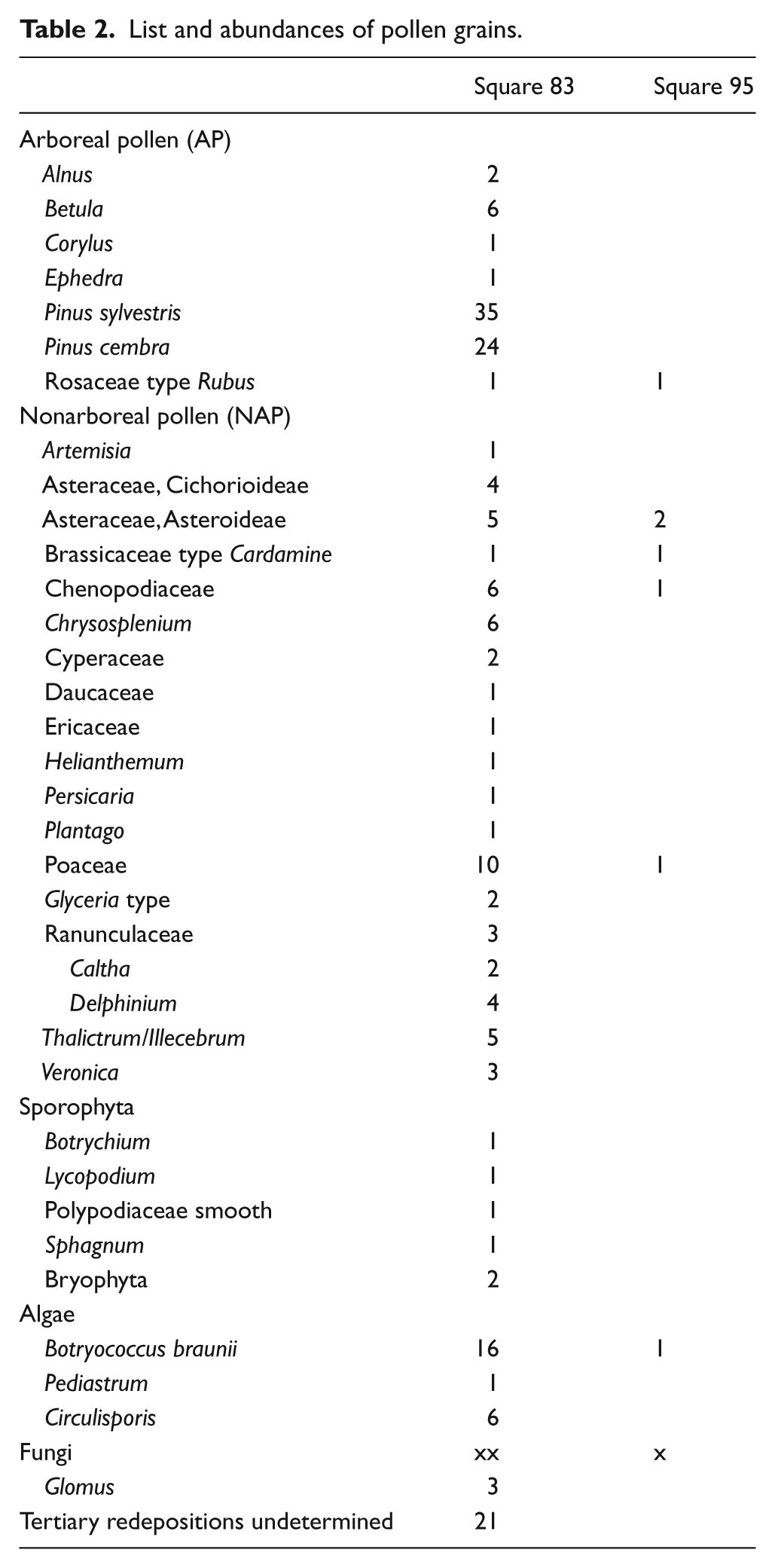
Palynological samples were picked from squares 83 and 95 (two samples from each of them). An accumulation of charred bones and overburnt sediment was detected in square 95, consequently a sediment was taken for palynological analysis; unfortunately, the pollen record from square 95 was very poor (see Table 2). Palynological samples were treated with HCl (20%), HF, KOH and HCl (10%) and heavy liquid ZnCl2 (density = 2 g/cm3) for standard maceration. The omission of acetolyse enabled clearer identification of contemporary pollen contamination. The final residue was diluted with glycerol. A Nikon Alphaphot 2 light microscope with 400× and 1000× magnifications was used for palynological observations. Taxa identification was mainly done according to Reille (1995) and Beug (2004). The pollen diagram was created using the POLPAL programme (Walanus and Nalepka, 1999).
The charcoal analysis was performed only on fragments from the largest fraction (>1 mm). The charcoals were identified using an episcopic interference microscope (Nikon Eclipse 80i) with 200–500 magnification and the reference collection. The additional standard identification keys were also used (Heiss, 2000; Schweingruber, 1990). The species abundance was expressed in the number of charcoal fragments (e.g. proposed by Delhon, 2006) and charcoal anthracomass (e.g. Carcaillet and Thinon, 1996). The individual taxa were weighted with an accuracy of 0.001 g. The sediment anthracomass (milligram of charcoal per kilogram of sediment; Talon et al., 1998) was derived from the charcoals larger than 1 mm.
Mollusc shells for malacological studies were derived from individual sediment samples taken with the bone samples for laboratory processing.
Results
Radiocarbon dating
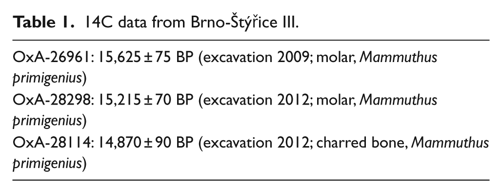
Most recent radiocarbon dating was done on samples taken during the excavations in 2009 and 2011. Only a single date from a mammoth molar was obtained because of the low collagen content of the other samples. Dating of other samples from the 2012 excavation was successful. From a total of four samples, only two dates were obtained, and these dates were similar to the previous ones (Table 1). Sample of burnt bone (OxA-28114) gave a good yield of carbon on combustion, and a CN ratio of 7, which indicates that there is some pyrolysed collagen remaining. In addition, the stable isotope ratio (d13C) was −22.2, which is acceptable for a large mammal. For this reason, the sample was OxA’ed. Dating of the next two samples of charred bones taken from the excavation in 2014 unfortunately failed because of very low yield.
14C data from Brno-Štýřice III.
Pollen analysis
A very interesting pollen spectrum was found in samples from square 83. Predictably about one-fifth of the total number of the determined pollen grains and spores consisted of palynomorphs redeposited from the older Tertiary sediments. Woody plants were relatively amply represented by pollen grains of pine with a slight prevalence of common Pinus sylvestris over Pinus cembra. Other species that were determined include Betula – finding of three grains in a clump testifies to a short transport, less commonly Alnus and sporadically Corylus (Figure 3). From the pollen grain ratios of woody species (arboreal pollen (AP)) 52% and herbs (nonarboreal pollen (NAP)) 48%, the character of vegetation appears to be a moderately forested landscape to parkland (Table 2). However, the proportion of woody plants (in which pollen of Pinus markedly prevails) can be greatly overvalued because of prodigious pollen production and the great flying range of pine pollen grains. The herbal constituent of the spectrum included the representatives of both drier and waterlogged habitats; for example, grasses Poaceae, floscular Asteraceae, Artemisia, or Chenopodiaceae occurred in drier areas, ascertained were Delphinium or Veronica. Bushes such as Ephedra, Rubus type or Helianthemum and Ericaceae were also represented. Elements characteristic for damp, waterlogged habitats or watersides such as Cyperaceae, Glyceria, Caltha, Chrysosplenium or scarce spores of Sphagnum were also found. Colonies of aquatic Botryococcus braunii were relatively abundant; those of the Pediastrum were sporadic. A paucity of thermophilic woody species together with taxa typical for cold periods of the Quaternary such as Helianthemum, Thalictrum and Ephedra determines the character of the climate.
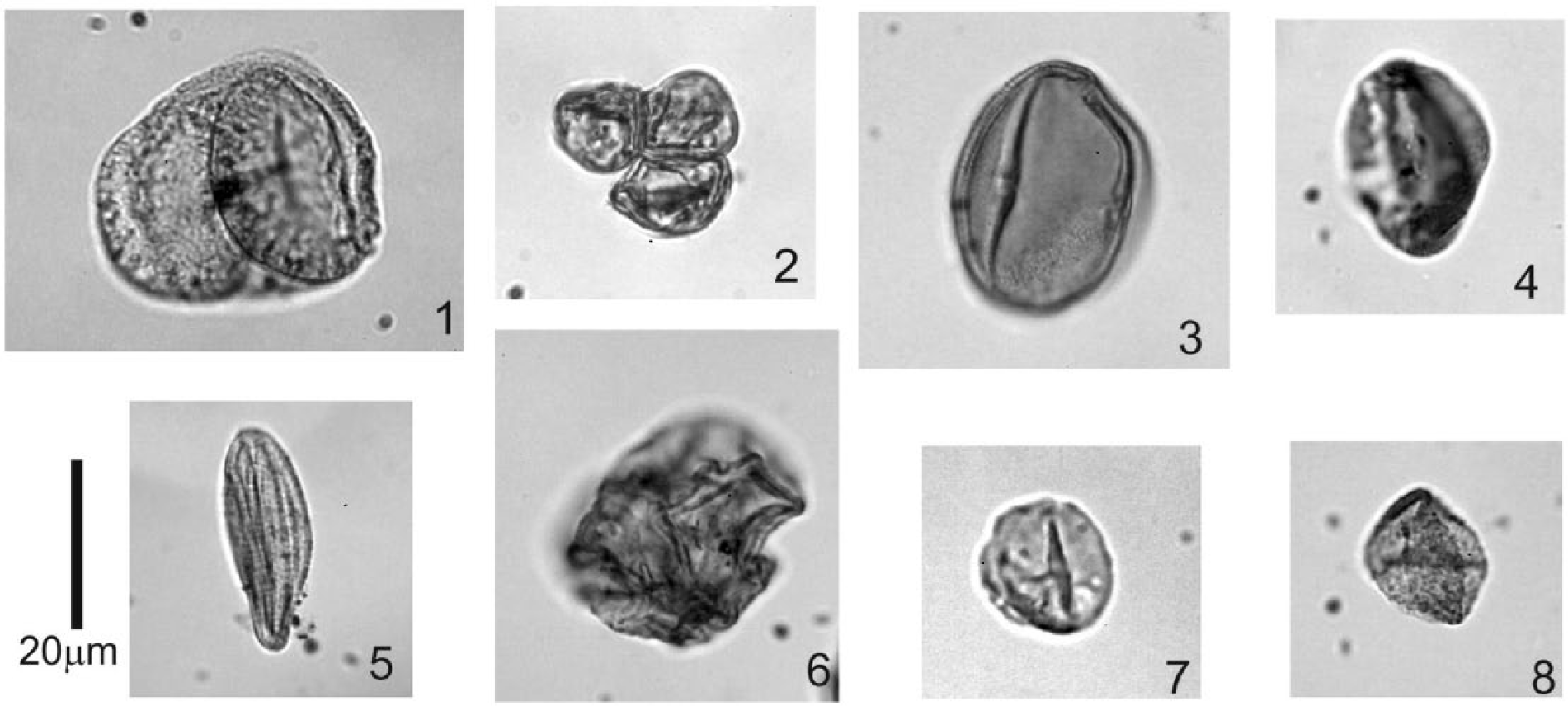
Photographs of the main pollen types (square 83), magnification 1000×.
List and abundances of pollen grains.
Anthracological analysis
A total of 89 charcoal fragments and 6 charcoal species from 13 samples were identified. Anthracological samples were distinguished by the low presence of small pieces of charcoals (the most common charcoal size was 2–3 mm). The anthracomass of analysed samples was very low. A significant feature of the entire assemblage of samples was a considerable prevalence of carbonised bone fragments over wood charcoals.
In the charcoal samples obtained from the Epigravettian layer, the dominant tree was Betula (34.8%), followed by abundant charcoal of Salix (27.0%) and Padus (21.3%). The presence of Picea/Larix (11.2%) was relatively common. Only scarce occurrences of Hippophae (4.5%) and Ericaceae (1.1 %) were recorded (Figure 4).
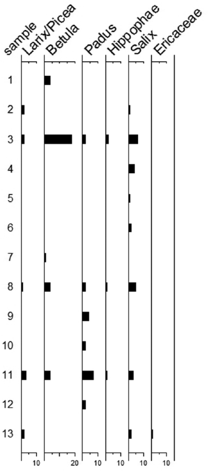
Number of charcoals in the study samples.
Malacological analysis
The first representatives of malacofauna that were found are Pupilla loessica (9 pcs), Vallonia excentrica (1 pc) and Helicopsis striata (1 pc) coming from the hearth area (square 9/Q, excavation 2009; determination by L. Juřičková; Nerudová et al., 2012). Other individuals of the Pupilla loessica species (determination by M. Horsák) were found during the next season of excavation (i.e. 2012): square 35 (6 pcs), square 48 (2 pcs), square 49 (1 pc), square 26 (1 pc) and square 22 (1 pc).
Discussion
Proxy data serving for the reconstruction of palaeoclimate could not be obtained through systematic sampling, because neither the state of preservation and the character of the Pleistocene sediments nor the character of rescue archaeological excavations allowed it. Despite several pollen samples taken, only one was positive for determination, and in this single case, it was taken close below the archaeological layer level (at its base). Relatively numerous shells of bivalves were found solely in relation to laboratory processing of large fragments, especially mammoth bones; at the same time, it has to be stressed that microfauna was not ascertained at all. In view of the soil chemistry influenced by post-deposition processes, the shells were always preserved only in the sediment and close to scarce bigger bone fragments or hearths; contrary to the surrounding area, such environment is always more calciferous, which facilitated their preservation (Nerudová et al., 2012; environmental requirement in general, for example, in Juřičková et al. (2014)). Determination of the osteological material was greatly impeded by its fragmentary character and severe surface deterioration, even in bones of large mammals with thick compact bones (Roblíčková et al., 2015). However, although we took all of the macroscopically apparent charcoals, and also the entire sediment from the places of hearths, the numerous tiny burnt fragments turned out to be animal bones, not woody species. Nevertheless, both archaeological and palaeobotanical analyses brought interesting, mutually complementary and corresponding results that are in harmony with the radiocarbon dating of the site.
Pollen analysis indicates scarcity of temperate woody species at the site and the presence of taxa typical for cold periods of the Quaternary determining the character of the climate as cold and dry. Parkland vegetation with the development of both drier and waterlogged habitats near water streams was reconstructed.
According to the determination of malacozoological analysis, the ascertained individuals belong to the typical representatives of loess steppe, since in the late glacial Pupilla loessica fades away (Horáčková et al., 2015; Horsák et al., 2010; Ložek, 1990, 2001, 2006).
Anthracological analysis recorded a dominance of Betula, common presence of Salix, Padus, Picea/Larix and only scarce occurrence of Hippophae and Ericaceae in study samples. These results indicate a cold, dry climate which is consistent with results and reconstructions. The matrix of landscape was probably more or less treeless. Open woodland with Betula, Salix, Padus and Picea/Larix was restricted to relatively moist banks of the river and protected valley. We can find the recent vegetation analogy in the river banks in southern Siberia (Magyari et al., 2014a) or northern Mongolia. The mixture of Salix, Padus, Betula (e.g. Betula fusca), Picea obovata and Hippophae rhamnoides formed typical vegetation composition in the vicinity of rivers or streams.
The cold and dry climate at the site is also indicated by the representatives of mammoth steppe fauna (of which most plentiful was exactly the Mammuthus primigenius, with Equus germanicus, Rangifer tarandus or Coleodonta antiquitatis as accessory species) and the results of analyses of carbon and nitrogen isotopes. Numerous fragments of animal bones could have resulted from deliberate human activity, substituting bones for shortage of wood in a period of shortage during the glacial maximum. Similar practices were ascertained, for instance, in Předmostí I-06 (Beresford-Jones et al., 2010), Dolní Věstonice II (Beresford-Jones et al., 2010; Svoboda, 1991a) or Grub-Kranawetberg (Bosch et al., 2012), and researches show the use of bones as fuel was a ‘common behavioural pattern during the Middle and Upper Palaeolithic in Northern Europe’. The use of bones as fuel was described in detail in the contribution by Bosch et al. (2012) since a more detailed analysis of this phenomenon is not a subject of this study.
This is where the results of radiocarbon dating and other scientific analyses diverge to some degree. After calibration (CalPal: Weninger and Jöris, 2008, and IntCal2014: Reimer et al., 2013), all of the data acquired from the site of Brno-Štýřice III so far form two peaks with an interval of roughly 1000 years GrN 9350: 17,620 ± 120 cal. BP and OxA 26961: 18,880 ± 90 cal. BP, that is, just after the stated interval of LGM (21 ± 2 kyr cal. BP). All new 14C dates were obtained from the mammoth bones and mandibles, representing the only material found at the site from which it was possible to at least partly obtain any dates; these bones were found in close proximity to stone artefacts and within the same archaeological layer. Tools were also found in the sediment within the mandibles. We consider this close contextual association to be strong presumptive evidence for the contemporaneity of the lithic industry and mammoth bones, and considering the homogeneity of the dates, it is very possible that the site’s occupants gathered the remains of mammoth carcasses.
However, the results of the pollen, anthracological and osteological analyses documented a similar character of surrounding habitats. The landscape was more or less treeless. The vegetation was mostly formed by shrub tundra vegetation with grassy loess steppe. Open woodland with birch and willow occurred in relatively moist river banks (of the nearest Svratka River) and foot of a hill (the Červený kopec Hill) with more favourable microclimatic conditions (Ložek, 2001, 2009).
V. Ložek (2010) states,
loess provides most evidence on the glacial environments in dry warm areas of Central Europe, which – in contrast to the conditions in north-western Europe – … never had the character of northern tundra, but of cold continental steppes and barren lands of Inner Asia instead. A clear testimony brings the loess fossil fauna, primarily the almost ubiquitous snails, the communities of which were preserved in the loess in secondarily undisturbed original appearance, enabling a critical comparison with similar recent snail assemblages of Inner Asia.
Nevertheless, on the grounds of our environmental analyses, manifestations of a slight warming in this period were not corroborated. Considering that the improvement of climatic conditions in the period shortly after the LGM (LGT) was only moderate, the changes in vegetation and fauna were probably relatively small; the microclimatic factor that enables surviving of typical zoocenoses (e.g. snails) in microclimatically suitable conditions in the face of the generally prevailing climate has to be considered as well (e.g. Horsák et al., 2015; Juřičková et al., 2014; Ložek, 1990, 2001, 2006).
Regretfully at present, we do not have larger quantity of data regarding the LGT environment in archaeological context available for the studied region. Therefore, we have to rely on information characterising the previous last cold oscillation instead.
If we take into account published isotopic data for mammoth in Europe and results of analyses of carbon and nitrogen isotopes in Brno-Štýřice III (Roblíčková et al., 2015), the results fit well together and generally confirm a cool steppe environment with low precipitation (Kovács et al., 2012; Pryor et al., 2013). The isotopic values from Brno-Štýřice III correspond to the Late Gravettian environment, especially in Moravia region (Roblíčková et al., 2015).
For the Middle Danube region in the LGM period, the landscape is characterised as a combination of cold loess steppe and mosaic parkland (Feurdean et al., 2014; Heiri et al., 2014). In central and eastern part of Europe, the major vegetation type of megabioms of the type cold deciduous trees is represented by Alnus, Betula, Salix and Populus. Picea, Pinus, Abies, Larix and Juniperus represent coniferous trees. Grass and shrubs are represented by Ericaceae, Calluna, Hippophae, Poaceae, Cyperaceae and other NAPs. Artemisia and Chenopodiaceae/Amaranthaceae represent xerophytic herbs (Feurdean et al., 2014; Heiri et al., 2014).
We have to consider the station at Stránská skála IV the nearest analogous and at the same time archaeological site. The Epigravettian site, dated at 18,220 ± 120 and 17,740 uncal. yr BP, yielded evidence of hunting of Equus, which prevailed, Rangifer tarandus, Bos, Mammuthus and Coleodonta antiquitatis. The mollusc successions acquired is indicative of a major biological rearrangement of the sediment since together with Pupilla loessica, also a striatic fauna was found, if it were a homogeneous successions (Svoboda, 1991b). Herb assemblage was also acquired from this site, and stratigraphy made its assessment complicated (the Epigravettian industry was situated in the uppermost part of the Weichselian loess also in this area; thus, it became secondarily turned into soil by the superposed Holocene horizon). Together with less climatically demanding woody species (Betula, Salix, Pinus, Corylus and Alnus), the sample also contained herbs (Cyperaceae, Poaceae, Artemisia, Asteraceae-Tubiflorae, Ericaceae, Lythrum, Chenopodiaceae and Silenaceae), ferns (Polypodiaceae) and moss (Sphagnum; Svoboda, 1991b).
In the South Moravian region, the profiles in Dolní Věstonice II or in Bulhary can be considered the closest regional and temporal analogous situation. Pollen analyses indicate that towards the end of the Weichselian interpleniglacial, coniferous trees (pine and spruce) were prevalent in Dolní Věstonice II, although more demanding woody species such as oak and beech also appear sporadically. Pollen grains of these more demanding species were also ascertained in the filling of the calva from triple burial at this site. According to H. Svobodová (2002), the herb spectrum points to forest–steppe character of the environment (Svobodová, 1991). Water and peat environment in the surroundings is indicated by Myriophyllum, Sparganium, Potamogeton, Trapa natans and algae (Svobodová, 1991). Anthracological analysis supports the presence of Larix, Picea/Larix, Pinus sylvestris, Pinus cembra, Betula, Hippophae and Juniperus at this site (Svoboda et al., 2015).
Anthracological analyses from the nearby Dolní Věstonice I confirmed the occurrence of pine, spruce and larch; further analyses testify to fir, perhaps also poplar (see Beresford-Jones et al., 2010; Svobodová, 2002). In the pollen spectrum, obtained from the core situated near the Bulhary Village and reaching down to about 10 m of aeolic loess layers and some 40–50 cm in thickness of compressed organogenic sediments (the moss peat and algal gyttja; 25,675 + 2.750–2.045 BP; Hv 10,855), coniferous species prevailed, birch, juniper, but also scattered temperate deciduous trees (Ulmus, Acer, Quercus and Tilia) were found, and these could grow at favourable sites in relation to relief. Unfortunately, the result of pollen analysis from this locality reconstructed vegetation closely before LGM. In the assemblages, over 200 types of palynomorphs (pollen, spores, etc.) have been found, which indicates a very rich flora and vegetation growing in at least six different biotopes of the Pálava Hills region (Rybníčková and Rybníček, 2014). The spectrum indicates grass and herb plant steppe community. The vegetation also comprised aquatic and swamp plants and ferns (Rybníčková and Rybníček, 1991, 2014; Svoboda et al. 2002).
Not only anthracological or pollen results but also various malacological analyses corroborate that the sporadic but several times observed findings of temperate deciduous trees could indicate the existence of refugia, which were preserved in more favourable enclaves – on southerly oriented slopes of the Pálava Hills – after the climatic deterioration (Juřičková et al., 2014; Ložek, 2006, 2009). According to Musil (1999, 2003), we can presume that such refuge areas facilitating growth of woody species requiring higher temperatures could have persisted since the previous interglacial; for the area of Moravia, Ložek (2009) or Horáčková et al. (2015) and Juřičková et al. (2014) argue for their existence on the grounds of malacozoological studies.
We know of pollen spectra capturing the LGM period from several sites in the Moravian Karst, for example, the Kůlna (layer 6; see Svobodová, 1988) or Barová (Seitl et al., 1986) and the Balcarka Caves (Doláková, 2010). At Balcarka Cave, prevailing herbs were found together with pollen of Betula in the sediment dated at 28,360 uncal. BP, captured inside the cave (Doláková, 2010). Within layers 11 and 12 in the Barová Cave (Seitl et al., 1986), the share of woody species increased and decreased several times (amounting up to 56% in the central part) – with prevalent Pinus, present Betula, Alnus, Picea and Corylus. In the herb spectrum, Poaceae and Asteraceae prevailed; Helianthemum, Selaginella, and Ephedra were present. Broadleaved trees requiring higher temperatures were not captured at the site. Nevertheless, alder, spruce and hazel do not represent typical tundra vegetation, either. Watercourses and the rugged relief (compare Lisá et al., 2013) probably made the climate more moderate in these areas.
The presence of macrofossil and charcoal records from the period shortly after LGM is still very rare in Central Europe. In addition to the presented site of Brno-Štýřice III, another significant site in the broader regional context is Mohelno-Plevovce (Škrdla et al., 2015); upon the anthracological analysis, it reconstructs the vegetation shortly (19,690 ± 120 cal. BP) after the LGM. The results of anthracological analysis indicate cold and dry shrub tundra vegetation, patches of open woodland with Salix, Betula and Juniperus and grassy loess steppe (Škrdla et al., 2015).
Similar climatic and vegetation conditions, closely compared with the Central Europe LGM climate, were described in detail from Altai region in southern Siberia. This region is recently regarded as the best known modern analogue of the last Pleniglacial of central Europe (Horsák et al., 2010). The results of studied spectrum of snail taxa indicates, that the full-glacial landscapes of Central European lowlands were not completely dominated only by open and dry loess steppe, but they contained a significant component of shrubby vegetation, patches of wet habitats and probably also areas of woodland at sites with a more favourable climate (Horsák et al., 2010).
Conclusion
At Brno-Štýřice III, evidence of human occupation in the end of the last (Weichselian) glacial was situated in the uppermost part of the Last Weichselian loess affected by intense Holocene processes of turning into soil. As a typical aeolian calcareous sediment, loess facilitates preservation of a certain type of material, especially terrestrial snails.
Despite unfavourable deposition conditions, we managed to ascertain new information augmenting the picture of local environment of the LGM/LGT in the context of the Middle Danube region. Although this information confirms the contemporaneous incidence of plant assemblages favouring lower temperatures, at the same time, it is evident that humans chose suitable temperate refuges close to water resources for their settlement, where they were adequately suggest more favourable microclimatic conditions protected from extremes of the climate.
The ascertained species composition of anthracological samples differs from the collections from other Central European LGM sites (e.g. Dolní Věstonice IIa; Svoboda et al., 2015); this may be influenced by the position and character of settlement. Abundant presence of charcoals of Salix and Padus corresponds to microclimatically more favourable situation of the site near a watercourse. Scanty representation of woody species charcoals against very abundant presence of charcoals from bones is indirect evidence of scarcely represented woody species in the vicinity of the studied site, whereas it has to be mentioned that low abundance of charcoal was probably recorded also at other archaeological sites dated back to the LGM period (Předmostí).
The charcoal analysis reconstructed the presence of sparse birch groves in the vicinity. These groves were probably tied to microclimatically favourable conditions (e.g. damper northern slopes) within the prevailing cold steppe or steppe–tundra. Recently, it is possible to come across analogous types of vegetation in Siberia (Horsák et al., 2010, 2015; Magyari et al., 2014a) or Mongolia. These habitats are characterised by both low temperatures during winter season and cold dry winds and very low rainfall, which impose large limitations on the presence of dense coniferous forests (dark tajga forests). Numerous fragments of animal bones could have resulted from deliberate human activity.
We would like to point out the importance of the results, especially in the context of the still poor known archaeological background, which is based mainly on the nonstratified sites. At Brno-Štýřice III, occupation by humans and species composition of vegetation was apparently influenced by the mentioned vicinity of a large waterway. Keeping to the outcomes of radiocarbon dating together with other analyses, we draw a temporal link of the settlement in Brno-Štýřice III more probably with the LGT period. The site is an exemplification of a microclimatically favourable refuge area serving for humans towards the end of Upper Palaeolithic, the period for which absence of archaeological evidence in a considerable part of Europe corroborates the decolonisation of vast areas prior to the onset of the Magdalenian settlement. We hope that the results will be helpful in the discussion concerning the climatic conditions and LGM/LGT central European occupation.
Footnotes
Acknowledgements
We are very grateful to Michal Horsák and Lucie Juřičková for determination of mollusc fauna and Martina Roblíčková for many valuable comments on the faunal composition. We would like to mention the anonymous reviewers for their valuable comments on this manuscript.
Funding
The research reported here was financially supported by the Ministry of Culture of the Czech Republic by institutional financing of long-term conceptual development of the research institution (the Moravian Museum, MK000094862; Z. Nerudová), institutional support of Institute of Geological Sciences, Masaryk University – 312222 (N. Doláková) and GAČR 13-11193S (J. Novák).