
Abstract
This article brings together in a comprehensive way, and for the first time, on- and off-site palaeoenvironmental data from the area of the Central European lake dwellings (a UNESCO World Cultural Heritage Site since 2011). The types of data considered are as follows: high-resolution off-site pollen cores, including micro-charcoal counts, and on-site data, including botanical macro- and micro-remains, hand-collected animal bones, remains of microfauna, and data on woodland management (dendrotypology). The period considered is the late Neolithic (c. 4300–2400 cal. BC). For this period, especially for its earlier phases, discussions of land-use patterns are contradictory. Based on off-site data, slash-and-burn – as known from tropical regions – is thought to be the only possible way to cultivate the land. On-site data however show a completely different picture: all indications point to the permanent cultivation of cereals (Triticum spp., Hordeum vulgare), pea (Pisum sativum), flax (Linum usitatissimum) and opium-poppy (Papaver somniferum). Cycles of landscape use are traceable, including coppicing and moving around the landscape with animal herds. Archaeobiological studies further indicate also that hunting and gathering were an important component and that the landscape was manipulated accordingly. Late Neolithic land-use systems also included the use of fire as a tool for opening up the landscape. Here we argue that bringing together all the types of palaeoenvironmental proxies in an integrative way allows us to draw a more comprehensive and reliable picture of the land-use systems in the late Neolithic than had been reconstructed previously largely on the basis of off-site data.
Keywords
Introduction
The main purpose of this article is to contribute to a long-standing and ongoing debate on the type of land use in the late Neolithic (LN hereafter; c. 4300–2400 cal. BC; Figure Supplemental material 1 available online) in the regions bordering the Alps (Figure 1). There are generally two extreme positions, which can be summarized as ‘permanently cultivated plots’ versus ‘shifting cultivation’ models. The first hypothesis is based on archaeobiological on-site data (for definitions, see Jacomet, 2007b) and ethnographic sources, the second rests to a large degree on off-site data, but also experimental work. Whereas off-site evidence is primarily based on pollen and micro-charcoal, on-site evidence relies on archaeobotanical and isotope analyses of a whole range of materials, notably botanical macro- and micro-remains, especially weeds and crops, archaeozoological remains and animal dung, as well as wood remains (for a more thorough description of the evidence and citations, see Supplemental material text, chapter ‘State of research and interpretation tools’, available online).
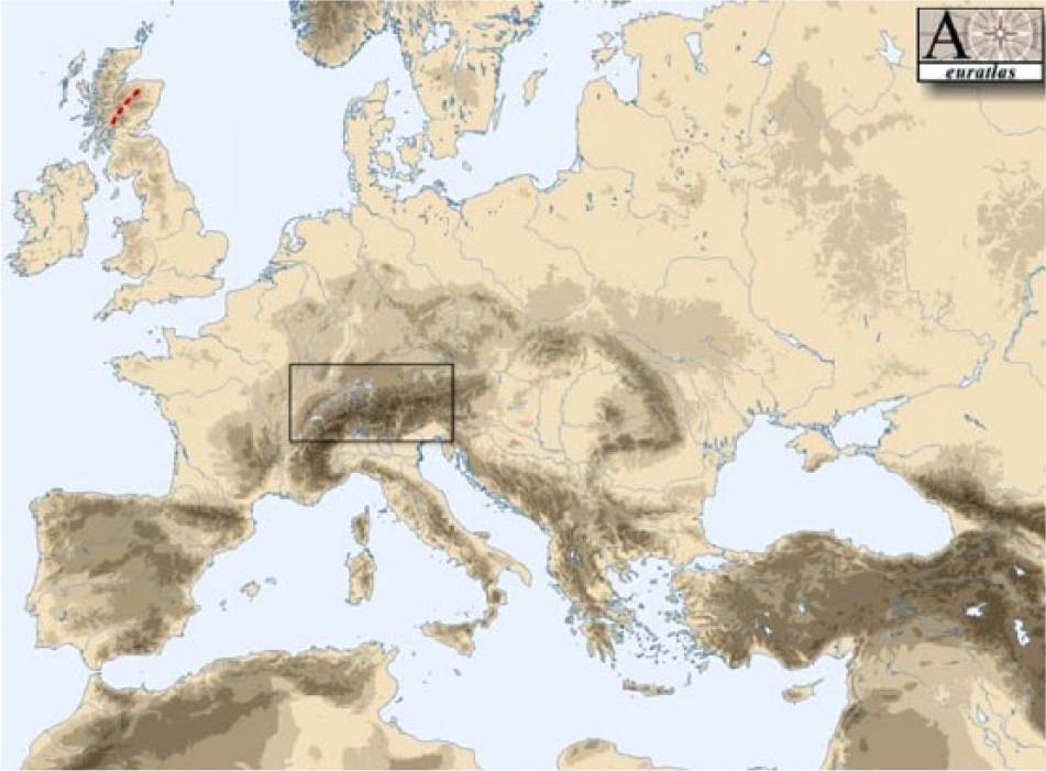
Map of the area considered in this article. From Euratlas http://www.euratlas.com, slightly modified by S Jacomet.
For many years, various researchers have stated that empirical on-site data suggest that slash-and-burn cultivation was not practised (at least not regularly) during the LN in the alpine foreland (see, for example, Brombacher and Jacomet, 1997: 270 f; Hosch and Jacomet, 2004: 128 ff). They favour the idea of a sophisticated landscape management, which also included the use of fire. Fields, once cleared, are thought to have been used relatively permanently and worked intensively, and this included weeding and perhaps even manuring. Yet the idea of shifting cultivation is surprisingly resilient, despite much empirical data against it. The main reason for this is that the more marginal landscapes, including the hilly and mountainous areas of the Alps themselves and the regions bordering them, are considered as less amenable to agriculture, for reasons related to climate and/or poorer soil quality (Kreuz et al., 2014; Schier, 2009). This is seen in contrast to early and partly middle Neolithic settlement areas (Altsiedellandschaften), which were established from 5500 cal. BC onwards on the most fertile loess soils of Central Europe (see Kreuz, 2012) where slash-and-burn is thought to have been unnecessary because the natural soil fertility was high enough. The alpine areas are thought to have been settled only relatively late (after around 4400 cal. BC) by agro-pastoral communities and the only option to farm in such landscapes would have been shifting cultivation (see the so called ‘tertiary neolithisation’ or ‘tertiäre Neolithisierung’ after Schier, 2009: 19 ff). Recently, however, systematic surveys have illustrated that the prealpine midlands of France and Switzerland were settled by middle Neolithic communities from 4800 cal. BC onwards (Boisaubert et al., 2001; Ebersbach et al., 2012; Kreuz et al., 2014; Martin, 2014, 2015).
In this article, we undertake for the first time a comprehensive and critical comparison of the two types of palaeoenvironmental data (Figure 2) for the central European lake-dwelling area, which should enable us to assess which of the two existing hypotheses are the more plausible or probable. We discuss methodological problems and combine the existing evidence in order to present an integrative new view of LN human–animal–environmental interactions. The prealpine environments of Central Europe are probably the world’s best location for such an attempt. Here, in the last 30 years or so, a large amount of high-resolution on- and off-site data have been gathered and studied (for details, see Supplemental material text chapters ‘State of research and interpretation tools’ and ‘Results of on-site data: Basic aspects of animal and plant husbandry’, available online). Indeed, the presence of many lakes of glacial origin, which offer excellent preservation conditions, makes the region eminently suitable for both types of investigations. During the LN, the so called ‘pile dwellings’ on lakeshores and in bogs were in existence (Suter et al., 2009) and these have left some of the best preserved on-site evidence worldwide. This is underlined by the fact that they were designated as UNESCO World Cultural Heritage sites in 2011 (http://www.palafittes.org; Menotti and O’Sullivan, 2013; see Figures 3 and 4). The region considered here may therefore also serve as a model region for both integrative archaeological research and earth system studies in the timeframe and region under study.

Scheme showing the relationships between the different types of palaeoenvironmental data considered in the text (on- and off-site data). By S Jacomet.

Map of Neolithic and Bronze Age sites of the northern alpine lake-dwelling area for which archaeobotanical data exist. Neolithic sites date between 4300 and 2400 cal. BC, Bronze Age sites between 1900 and 850 cal. BC. On most of the sites, several settlement layers of different ages were investigated. For detailed legend and references, see Tables 1 and 2, Supplemental material, available online.

Major regions of Switzerland and location of Neolithic and Bronze Age wetland and dryland sites with archaeozoological data. For detailed legend and citations see Tables 3 and 4, Supplemental material, available online (from Schibler, 2016).
Shifting cultivation versus intensive garden cultivation: State of the art
Here we shall address the two systems under review but refer readers to our more detailed overview of the state of research and interpretation tools available in the Supplemental material chapters ‘State of research and interpretation tools’ and ‘Results of on-site-data’, available online. Although the main topic of this article is agrarian activities, these cannot be understood without looking at the subsistence economy system as a whole, especially if the research agenda includes reconstructing cycles of land use and the role that fire played in shaping the landscape. Therefore, we shall consider different aspects of landscape management activities here.
On-site data
Methodological problems affecting the interpretation of on-site data include data collection techniques, sample sizes and representativeness, questions of interpretation of species composition (e.g. lack of modern analogues for the weed flora) and the problem of the ‘patchiness’ of wetland settlement layers with many factors influencing the artefact and ecofact composition of the samples. Extensive and profound research in the last few years has contributed to a better understanding of some of the methodological problems, but cannot be discussed in detail in this context (see the above-mentioned Supplemental material chapters, available online).
On the basis of archaeobiological analyses of more than 100 sites located in different natural environments of the prealpine regions (Figures 3 and 4), we can claim that our knowledge of Neolithic animal and plant husbandry is quite detailed: the economically most important domestic animals in the LN were cattle, pigs and sheep as well as goats (Schibler, 2006, 2016). For their successful keeping, at least semi-open land was needed. Animals also provided manure which may have played an important role in the agricultural system. An increase in herd sizes, mainly of cattle, towards the end of the LN has been observed (Ebersbach, 2002; Schibler, 2006 and Supplemental material Figure 2, available online). LN plant economy in the area under investigation was based on cereals on the one hand, and pulses, oil, fibre and medicinal plants on the other. The importance of the cultivars changed in the course of the LN (Figure 3, Supplemental material available online; see, for example, Herbig, 2009; Jacomet, 2006, 2007a; for more details, see Supplemental material text, chapter ‘Results of on-site data’, and relevant literature cited there, available online).
LN land use is mainly reconstructed with the help of weeds, largely on the basis of the weed spectra of cultivar stocks (see Figure 5 and Supplemental material Table 5, available online and literature cited there). A compilation of all available data from the Northern Alpine foreland in the late 1990s revealed over 60 wild plant taxa that can be considered weeds in the LN (see tables in Brombacher and Jacomet, 1997: 258–261; Supplemental material Table 5, available online).
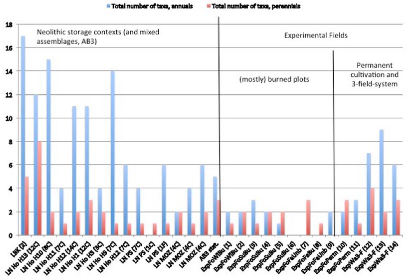
Numbers of annual (blue) and perennial (red) weeds in early and late Neolithic cereal and flax stores (from Brombacher and Jacomet, 1997, 2003; Kreuz, 2012; Maier, 2001) compared with those of the experimental fields at Wackershofen and Forchtenberg (data from the latter after Rösch et al., 2002a).
Besides annuals, perennials were also regularly present. There was a relatively diverse weed flora from the early phases of the LN onwards. Its composition is, however, not directly comparable to modern weed communities, which are dominated by annuals; we see the presence of many opportunistic ‘weedy’ taxa, which today are more typical of perennial ruderal stands, forest fringes and so on, which had also spread onto the fields. The latter taxa were most probably mixed in with woodland, woodland edges, coppiced stands and so on.
The results of both classic archaeobotanical studies and FIBS analysis (Functional Attribute studies; see, for example, Bogaard, 2004; for more details, see Supplemental material text chapter ‘Results of on-site data: Evaluation of the weed spectra’, available online) show coincidentally that the richest, most humiferous soils in the surroundings of the settlements were used for fields. The often high soil fertility values of the weeds point in the direction of some kind of manuring or to a naturally high soil fertility. Recently, the analyses of 15N isotopes in charred cereal grains from LN contexts have shown that some sort of manuring of the fields must have existed over longer periods (Bogaard, 2012; Bogaard et al., 2013; Styring et al., 2016). The regular presence of annuals gives clear indications of highly disturbed soil conditions on the fields. This suggests a labour-intensive management of plots, which must have existed for at least several years, interrupted by only short fallow periods of no more than 1 to 2 years. Perennials capable of vegetative propagation by dividuals are also indicative of highly disturbed plots because they can regrow from small parts (see also Kreuz, 2012: chapter 7).
Intensive field tillage appears to have been in existence as early as the earliest phases of the LN, and it becomes even more pronounced from the middle of the fourth millennium cal. BC onwards, when annuals are recorded in increasing quantities. Without a high degree of disturbance, annual weed species would not have survived and would have rapidly become overgrown by competitive, mostly perennial weeds or woodland clearing taxa (see Figure 5).
There are also clear indications that stubble fields and fields left fallow were grazed, which had the side effect of manuring them (the same was noticed already in the early Neolithic LBK (LinearBandKeramik; LBK phase I to phase II; Kreuz, 2012)). The regular presence of winter annuals points to winter cropping of at least some cereals (such as naked wheat or emmer), especially from Horgen times (around 3400 cal. BC) onwards. The results of the FIBS evaluation show that cereals were predominantly planted as winter crops (80% of the cases; e.g. Bogaard et al., 2013). Regular admixtures of small proportions of a second cereal in stocks suggest that some kind of crop rotation was practised, because it is an effective way of keeping pests and diseases at bay as well as to keep soil nutrient contents more balanced (Jacomet et al., 1989: 166 ff).
In wetland settlement layers, animal dung, mostly of ruminants (sheep/goat and cattle) is very often encountered (a very good example is shown in Figure 6). Investigations of plant macro- and micro-remains (mainly pollen) in ruminant dung gave valuable indications of the surfaces on which the animals grazed (see, for example, Kühn et al., 2013; for more details, see Supplemental material text, chapter ‘Results of on-site data’, subchapter ‘Evidence based on ruminant dung’, available online).
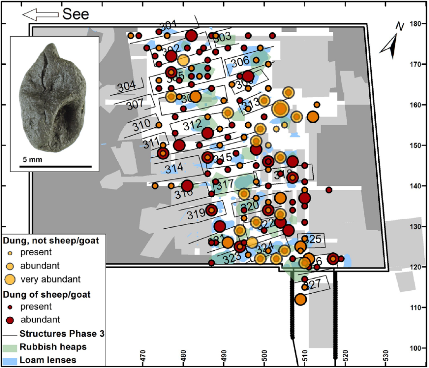
Presence of ruminant dung in the settlement layer of Zürich Parkhaus Opéra layer 13 (Horgen culture, 3175–3157 cal. BC). Figure by F Antolín. The photograph shows a goat/sheep dung piece (photograph by G Haldimann, ©IPNA Basel University). For more details, see Antolín et al. (2016).
In several of the dung pieces of small ruminants investigated in different settlements covering the fifth and fourth millennia cal. BC, there are clear indications that animals grazed on burnt surfaces of land, as evidenced by high amounts of micro-charcoal (Figure 7a and b; Kühn and Wick, 2010).
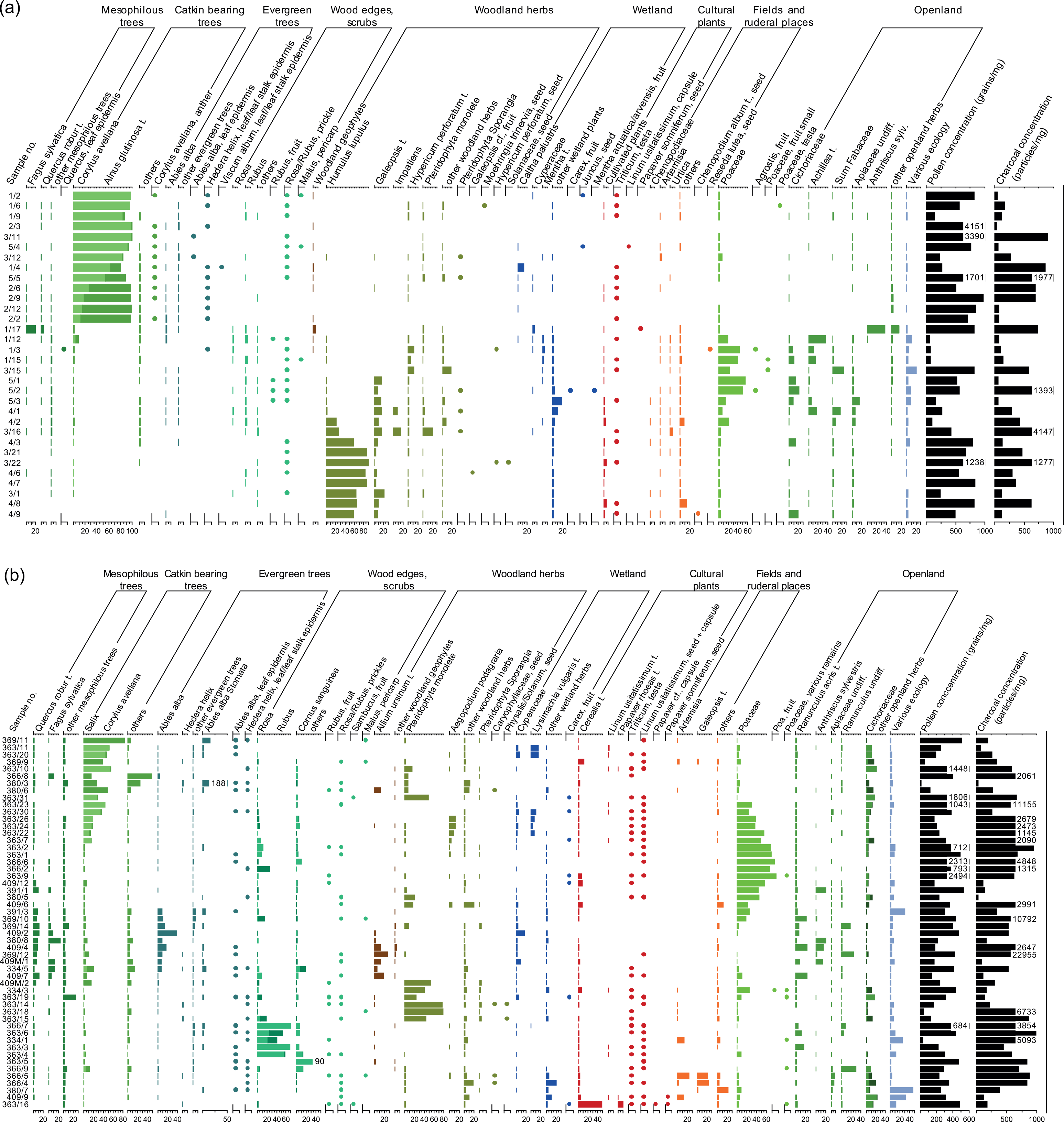
Diagrams of plant macro- and microremains in dung of small ruminants. (a) Egolzwil 3 (ca. 4260 cal BC); (b) Pfäffikon-Burg (ca. 3100 cal BC). Analyses by M. Kühn (macroremains) and L. Wick (pollen). Percentage values of major pollen taxa and other microremains (bars), combined with macroremains (dots; all the taxa given as presence/absence) and total pollen and microcharcoal concentrations (pollen grains and charred particles per mg wet material). All the plant remains are grouped into different ecological habitats or fodder types, respectively, where the total pollen percentages of each group are summarized in the first curve. For detailed explanations see Supplemental material Text. Figure by L. Wick.
The seeds, vegetative plant parts and pollen in these pieces of dung point mostly to woodland as grazing ground, and not to the grazing of fields or ruderal/fallow places which were burnt before cereals were sown.
This suggests that LN people burnt parts of the woodland deliberately, probably to obtain more pastures (and also foraging and hunting grounds, see Supplemental material text chapter ‘Results of on-site-data’, subchapters ‘Evidence based on open-land-taxa’ and ‘Evidence based on gathering and hunting’, available online) – as is well known from ethnographic sources from climatically similar regions (e.g. Smith, 2011). Remains of dung with plant spectra that would indicate the presence of stubble fields or fallow land do not contain high amounts of micro-charcoal (as shown by the lowermost sample in Figure 7b).
Furthermore, evidence based on dendrotypology (dendroarchaeology) gives many indications of different types of woodland management, including coppicing and coppiced stands (see, for example, Billamboz, 2014; for more details, see Supplemental material chapter ‘Results of on-site data’, subchapter ‘Evidence based on dendrotypology’, available online). Gathering and hunting played an important role too and may have included targeted or specific landscape management practices, for example, the tending of hedges or fruit trees like crab apple trees or hazel bushes. All these types of landscape management were intertwined and cannot be seen in isolation.
Off-site data
Like those affecting on-site data, the methodological problems of off-site data are manifold: they pertain to data collection techniques (e.g. Is micro-charcoal counted or not? Or time resolution of the data), problems of species determination, the explanatory power of species correlated to lake/mire catchment areas, the question of actualistic comparisons, and the possible patchiness of prehistoric landscapes. Generally, as off-site data are extracted from natural environments, the differentiation between natural and anthropogenic impacts on the characteristics observed constitutes a major issue (Lechterbeck, 2013; Sugita, 2007a, 2007b). Off-site information on human impact and landscape management is based on observations documenting, for example, rapid changes in woodland species proportions, increases in the percentage of open land in general, peaks of charcoal and an increasing importance of single species or their combination with species which prosper in disturbed or open environments, such as Plantago lanceolata.
To date, the quality and quantity of off-site data available is unevenly distributed over the prealpine area. The best investigated areas are the regions of Lake Constance and the Hegau (Lechterbeck et al., 2014; Rösch et al., 2008, 2014), while data of the same quality (especially time resolution) from western or central Switzerland are barely available.
During land-use phases of the fourth and early third millennia cal. BC, many high-resolution pollen diagrams of the western part of Lake Constance (Figure 8) show a strong decrease in Fagus in several phases (e.g. Lechterbeck, 2013; Lechterbeck et al., 2014; Rösch, 2013; Rösch et al., 2014; ongoing research by L Wick; Figure 9).
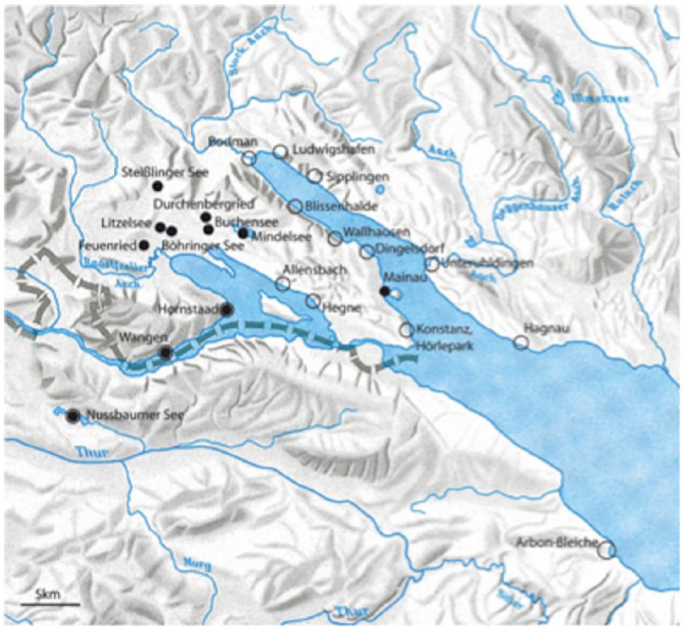
Location of the high-resolution pollen diagrams (black dots) in the western Lake Constance region (after Rösch et al., 2014: 122) (white circles represent archaeological sites with archaeobotanical investigations).
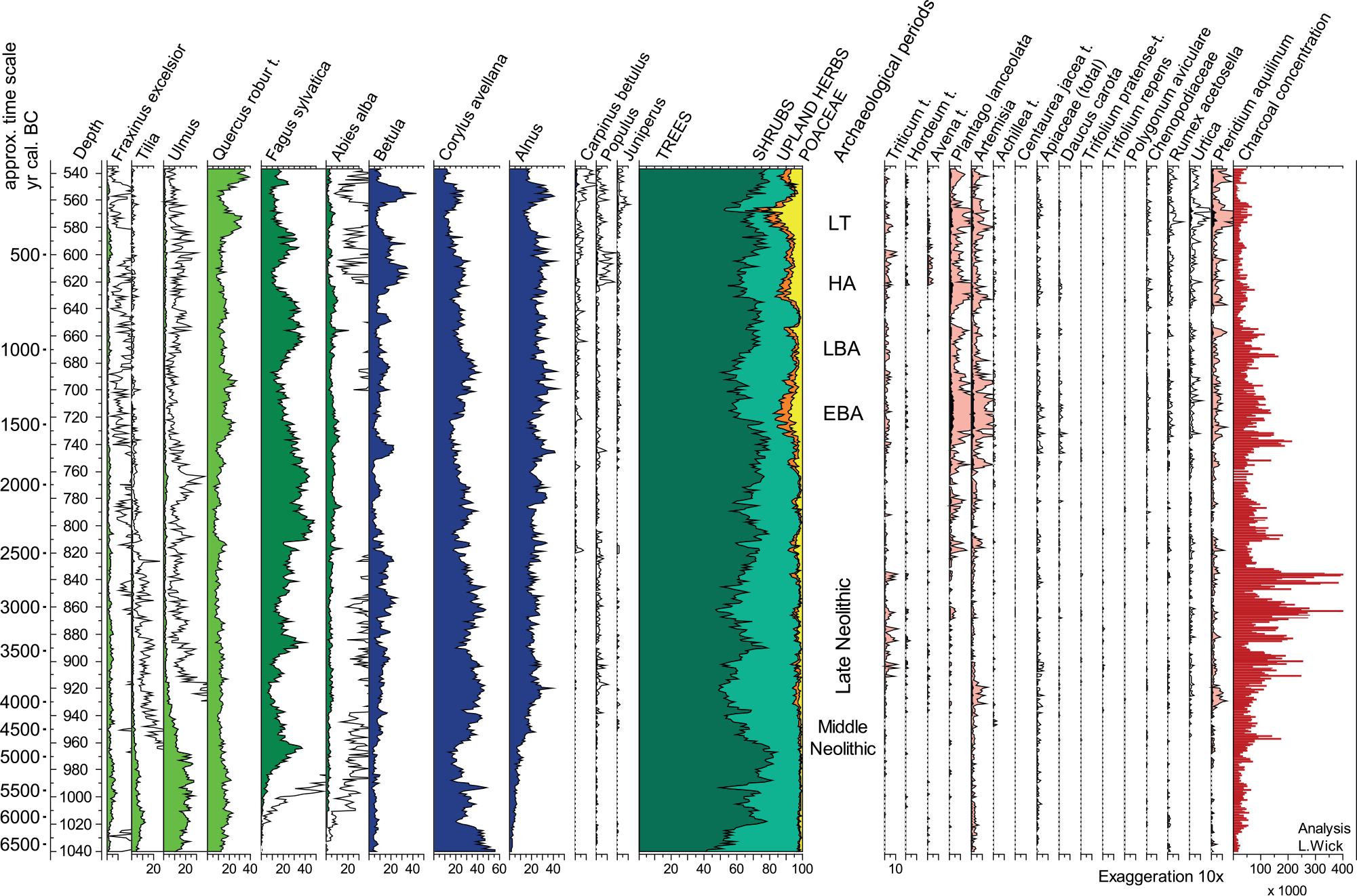
Pollen diagram (simplified) of the Mainau litoral, western Lake Constance. Analyses L. Wick. LBK: Linearbandkeramik (Early Neolithic, see Figure Supplemental material 1); EBA: Early Bronze Age; LBA: Late Bronze Age; HA: Hallstatt Period (Early Iron Age); LT: Latène Period (Late Iron Age). Figure by L. Wick.
In parallel, secondary forest elements such as Corylus and Betula and micro-charcoal increase. This is interpreted as a replacement of the Fagus-dominated woodland by semi-open or shrubby vegetation, probably also coppiced forests, coinciding with the beginning of the LN. The fluctuating micro-charcoal curves with high peaks are interpreted as indicating woodland burning, especially in the fifth and first half of the fourth millennium, when charred particles are much more frequent than those that are recorded both earlier and later. Therefore, the interpretation is that slash-and-burn cultivation was mainly practised in the earlier phases of the LN (most recently, Rösch, 2013; Rösch et al., 2014, see also Supplemental material text chapter ‘Results of off-site data’, available online). In the slash-and-burn model, fields are thought to have been rotated in a yearly cycle with long fallow phases (over 10 years) in between.
Recently, the main line of interpretation that posits that high frequencies of micro-charcoal in off-site data are caused by anthropogenic burning connected to agriculture has triggered a revival of the slash-and-burn hypothesis for Neolithic farming communities (see compilation in Schier (2009)), although it is a very old conception of how to begin farming in a wooded landscape (e.g. Clark, 1952; Modderman, 1971; older literature compiled by Troels-Smith, 1990; for a new synopsis, see Isaakidou, 2011: 92 ff).
To test the relevance of this interpretation, an experiment in a forested area of south-western Germany was designed (Ehrmann et al., 2014; Rösch et al., 2002a). The results show that slash-and-burn cultivation results in much higher yields than permanent cultivation (even with manuring). But these yields drop to near zero in the second year, forcing the constant relocation of fields. Clearing the forest, burning and preparing the fields leads to an average workload per hectare that is much higher than in permanent cultivation systems, and the demand for land is up to 16 times higher than for permanent cultivation. Rösch (2013: 114) points out that successful burning needs a very high amount of weak wood, that is, a fallow phase of about 12 years is necessary to produce sufficient wood for another fire.
A further argument for slash-and-burn cultivation is that there are (almost) no weeds in LN cereal stocks (Rösch et al., 2014: 131). This is in agreement with the experiments, where there were almost no weeds at all in the harvest.
The slash-and-burn hypothesis therefore combines a set of observations of LN on-site and off-site data: high charcoal peaks in pollen cores, a dense woodland to deal with at the beginning of the sequence, and finally high settlement mobility with sites occupied for just a few years up to slightly more than a decade (Ebersbach, 2010). The authors mentioned consider that it was the shifting cultivation pattern that could have forced people to move their settlements so frequently. This is seen as representing a contrast to the early (LBK) and middle Neolithic settlement patterns; at that time, according to the most commonly accepted hypothesis, settlements were permanent for periods of several hundred years (see, for example, Strien, 2005). As settlement duration and dynamics differ between the early–middle and the late Neolithic, farming techniques must have differed too. Therefore, permanent agriculture in Bogaard’s (2004) and Kreuz’s (2012) view, is accepted for the LBK period, whereas similar results are rejected for the LN.
In a recent article, M Rösch (2013: 115) admits that burning was perhaps independent from agriculture and carried out for other purposes such as hunting or animal husbandry. This is based on observations of an abundance of charcoal in LN coprolites of sheep and goat, but an absence of such charcoal in the Bronze Age (BA; Rösch refers to unpublished data of L Wick; see below). In an article of 2008 (Rösch et al., 2008, but also Rösch, 2013: 115), Rösch considers that on-site data point to an intensification of agriculture in the later phases of the LN, in the Horgen culture (from around 3400 cal. BC onwards). However, off-site data still indicate that slash-and-burn agriculture and chopping down forests were being practised. He argues that it is not clear whether different agricultural regimes were being practised at the same time or whether the former slash-and-burn system was modified and improved, or both. One such modification could have been the fertilization of permanent fields on the best soils and the preparation of such fields for cultivation by burning wood brought in from a coppiced forest on less fertile soils.
In Final Neolithic Bell Beaker times (around 2300 cal. BC) – when settlements are located somewhat further away from the lakes – the slighter evidence of burning is seen in connection with the increased importance of animal herding and more extended pastures (Lechterbeck et al., 2014).
Discussion: Which land-use/landscape management is the more likely?
In the following section, the evidence and methodological aspects of the slash-and-burn hypothesis are discussed in detail and compared with other results from all kinds of data that could help us understand LN agricultural techniques and the wider economic and environmental context.
Is a comparison between early/middle Neolithic and LN micro-charcoal values possible?
From the onset of the LN onwards (in the western part of Lake Constance around 4000 cal. BC), the micro-charcoal values in off-site pollen diagrams are up to five times higher than those of earlier phases (see Figure 9). But can we really compare early and middle Neolithic charcoal values with LN values?
In the off-site pollen diagrams from the western part of Lake Constance, micro-charcoal curves begin long before the LN; in fact, micro-charcoal is present in the Mesolithic, although in lesser quantities than in the LN (e.g. in the diagrams of Durchenbergried and Hornstaad: Rösch, 1990, 1992). This is also becoming apparent in ongoing work on Mainau (Figure 9), Schleinsee, Degersee and Buchensee (unpublished data by L Wick). Micro-charcoal is also constantly present in the early and middle Neolithic periods, with even some high peaks during the middle Neolithic in the Mainau diagram (Figure 9). Then, from around 3900 cal. BC onwards until 2500 cal. BC, very high charcoal peaks become visible. This is unsurprising, as the pollen diagrams mentioned are close to LN settlement areas, whereas they are rather more distant from the early and middle Neolithic settlement zones. Known early and middle Neolithic settlements were located at some distance from the lake rich morainic areas, around 20 km to the west, in the region of Hegau (LBK Flomborn phase settlement, from 5300 cal. BC onwards, at Hilzingen: Stika, 1991; middle Neolithic Rössen culture settlement at Singen-Offwiesen: Dieckmann et al., 1998; Lechterbeck et al., 2014). It is, however, possible that the middle Neolithic charcoal peak in the Mainau diagram (around 4600 cal. BC; Figure 9) mirrors settlements nearby whose archaeological traces have so far eluded us (like in the region of Zürich, Ebersbach et al., 2012; Erny-Rodmann, 1995). As cereal-type pollen is also present, we can exclude that these traces were left by late hunter-gatherers.
In order to establish whether there was a real difference between micro-charcoal amounts in the early/middle Neolithic on the one hand and the LN on the other, we would need to have at our disposal off-site pollen cores in the immediate proximity of early/middle Neolithic settlements. There is, however, not a single (!) pollen diagram near an early Neolithic LBK-settlement in which micro-charcoal has been systematically investigated. Micro-charcoal was not counted in the Luttersee diagram (near an LBK-settlement in the region of Göttingen, Germany: Beug, 1992); neither was it counted in the floodplain profiles of the LBK-settlement region in the Wetterau (Hesse, Germany: Stobbe, 1996), or at Sersheim (near Stuttgart, Germany: Smettan, 1986).
To conclude, a direct comparison of LN off-site micro-charcoal from the lake-dwelling region with early to middle Neolithic micro-charcoal from the loess-regions is not possible because there are no equivalent data. If we cannot exclude a simple correlation between micro-charcoal peaks and the proximity of a contemporaneous settlement, then it will not be possible to reconstruct different land-use systems based on micro-charcoal values.
Are micro-charcoal values in off-site pollen diagrams related to cultivation?
Rösch (2013) argues for the existence of a slash-and-burn cultivation regime mainly in the earlier phases of the LN (the so called ‘Jungneolithikum’; see Figure Supplemental material 1, available online). But he concedes that in the later phases of the LN, from 3400 cal. BC onwards, a more permanent cultivation regime may have existed. However, in some profiles, the highest and most continuous micro-charcoal values occur after the ‘Jungneolithikum’, during the Horgen and Corded Ware phases (see Figure 9). This raises the question of why Horgen and Corded Ware people left so many traces in the micro-charcoal record if the landscape was already half-open bushland and cultivation had possibly become more permanent. And why does charcoal occur during all the periods analysed right up to the late BA or even later? These questions remain unanswered. Furthermore, charcoal peaks which reflect the burning of woodland to create new fields should result in higher amounts of NAP after burning events, but a detailed analysis to establish whether such a correlation is really visible in the data has never been undertaken. In any case, it becomes obvious that the interpretation of micro-charcoal values is far from straightforward. The sources of charcoal could have been very diverse. A direct link between high micro-charcoal values and cereal growing and its cultivation techniques is merely one possibility among a number of possible interpretations. Another would involve the burning of stubble fields to reduce the weed flora and pests (e.g. Kreuz et al., 2014). Hearth fires or catastrophic fires which burnt the settlements down (the latter was quite frequent, as we know from on-site data) are a further possible source of charcoal. That the input from hearths is likely to be considerable can be demonstrated by a rough and conservative calculation: if 50 households burn just 5 kg of wood per day, then in the course of 20 years more than 1800 tons of wood would be turned into ash and charcoal. Since the settlements were located on the shore and were flooded at least seasonally, there should be traces of such quantities of material, at least in off-site sediments close to the shore.
Occasional conflagrations would have increased the amount of charcoal. Be that as it may, if all the micro-charcoal was derived from hearth fires, we should at least see the same quantities in the BA, which is however not the case. Finally, natural fires could theoretically also be considered, but there are no pre-Neolithic micro-charcoal peaks which point in this direction in the region under consideration.
To conclude, the interpretation of micro-charcoal values in off-site high-resolution pollen diagrams is extremely ambiguous, and clear conclusions about the type of cultivation regimes applied in the LN cannot be drawn. It is however true that the highest average values are reached during the LN. This was obviously a period when burning played a more important role, and it is highly likely that the source of at least a (large?) part of the charcoal comes from ‘burning the landscape’, whatever the reason was (see below).
Can experiments prove shifting cultivation during the LN?
Experiments are of great value for testing the plausibility of one or another hypothesis. However, experiments concerning land use are very difficult to set up; for instance, the soil conditions are never the same today as they were thousands of years ago. Experiments are therefore not in themselves a proof – just because ‘it works’ – that prehistoric agricultural techniques were of one type or another.
The group around M Rösch has tested experimentally the land-use system (slash-and-burn) it had reconstructed on the basis of the high charcoal values in off-site pollen diagrams (see previous sections for citations). They concluded that slash-and-burn agriculture is the best, if not the only, method to practise successful agriculture with Neolithic tools and methods in a forested area on non-optimal soils. However, their experimental design has several drawbacks. First of all, the experimental plots are situated on soils with a pH value that is comparatively lower than the usual values of the morainic soils in the hinterland of the lakeshore settlements. This reduces the availability of nitrogen and phosphorous. Rösch et al. (2002b: 30 ff) state that the ash from burning, which raises the pH value, counteracts this. In addition, the plots were not thoroughly weeded – in opposition to what the weed composition indicates for Neolithic fields (see above). The results from unburnt plots showed that yields were very low or even non-existent, while they were high on burnt plots, where the fire had reduced competition by weeds, raised the pH value, and removed fine roots from trees and former forest vegetation (for yields, see the next section). It is hardly surprising that unburnt plots give little yields when they are located on acidic soil and left unattended, but this is not comparable to the techniques used in permanent cultivation systems. The result is therefore an unavoidable consequence of the experimental design and cannot be transferred to prehistoric settings.
Finally, the experimental plots were relatively small and surrounded by dense woodland, a setting which is again not comparable to Neolithic environments, at least not after a few hundred years of human impact, in the periods after 3500 cal. BC.
Despite their flaws, these experiments are of great value, because they have shown that shifting cultivation may have been feasible during Neolithic times in temperate woodlands north of the Alps. The experiments have also produced interesting data on workload in relation to yields and on the amount of woodland necessary to maintain a shifting cultivation system for several hundred years. The ratio of field under cultivation to fallow land turned out to be about 1:36 and therefore only 3% of the area around the settlements could be used for crop growing – the other 97% being used to produce fertilizer in the form of charcoal (Rösch, 2013). Above all, the higher workload and the much higher demand for land when applying a shifting cultivation system may have caused a problem (as the experiments have also shown). Before burning, the trees had to be cut down, the wood dried and transported to be stored in heaps. All this is hard and time-consuming work and would not have been undertaken without good reason (the very high yields, see above).
There are other types of experiments which have shown that permanent cultivation may have worked in Neolithic times. Unfortunately, they are located on soils over loess in the Rhineland, and are therefore rather distant from the lake-dwelling area. Such an experiment was carried out by Cologne University in the Hambach forest (Lüning and Meurers-Balke, 1980). The results obtained there were later used by Bogaard (2002) for her interpretation of early Neolithic land use.
To conclude, modern experiments inevitably have their shortcomings; in the best case, they can provide insights into how cultivation may have worked. They are, however, not a proof of the existence of one or another cultivation regime in prehistoric times, and their results should not be used as a main line of argument for reconstructing former farming regimes.
What were the yields when applying different forms of cultivation regimes?
Estimates of how high the yields in LN times may have differed greatly, and we are far from having answered this question (for an overview, see Bogaard, 2004: table 2.1). Historical data from medieval Europe with very low yield values (450–900 kg/ha) are based on three-field systems which had suffered from permanent cultivation that lasted for centuries and had too little manure input (see Reynolds, 1997). Most authors therefore agree that these data are hardly comparable with Neolithic data. Kreuz (2012: 123–124) assumes a minimal yield of 800 kg/ha for cereals and legumes for the early Neolithic LBK if the ratio between sown and harvested crops is 1:10; this corresponds to modern yields considered as ‘good’ in the traditional agriculture of the central Anatolian highlands where the climate is harsh (Ertug-Yaras, 1997: 229). Ethnographic data from a mountainous area in Asturias (northern Spain) show higher yields: there, manured and intensively worked permanent plots produce rather high yields of over 1500 kg/ha over many years (up to 1800–1900 kg/ha were recorded; Bogaard, 2004: table 2.1; see also Charles et al., 2002). Intensive garden cultivation including irrigation and manuring with up to 40 t/ha can increase yields to up to 2500 kg/ha, and for barley even up to 3000 kg/ha (Ebersbach, 2002: 133 and villages 18A–C).
The yields on the experimentally burnt plots at Schwäbisch Hall-Wackershofen and Forchtenberg in south-western Germany mentioned above were very high in the first year (2500–4000 kg/ha; only old strains of cereals considered; Ehrmann et al., 2014: 16), being close to the yields obtained by modern agriculture. In the following year, however, they dropped to near zero; the authors conclude that permanent cultivation with tillage but without fertilizer is not possible in south-western Germany. This is in strong contrast to manured and intensively cultivated permanent plots like those in Asturias which continue to give quite high yields for many years. There are also several ‘long-term-cereal growing’ experiments like the Rothamsted experiment (see Bogaard, 2004: 23 f) that gave reasonable yields over many years, even without manuring (for more information, see Baum et al., submitted).
To conclude, assumptions about the amount of agricultural land needed in Neolithic times can vary dramatically depending on which yield values and which agrarian techniques we use. Quite intensive cultivation methods (‘garden-like’ to use Bogaard’s words, ‘park-like’ in the early Neolithic LBK according to Kreuz) coincide with small plots of less than half a hectare per person to meet the calorie requirements, while slash-and-burn techniques with a 20-year-rotation system may need up to 10 times more land in the vicinity of the villages and have to be kept undisturbed to allow for forest regrowth to fuel the next burning event. Yields mainly depend on the nutrients available for growing, and these can be kept to a sufficient level by different methods: regular shifting of fields to ‘virgin’ soils, burning, manuring, or good crop rotation systems including pulses.
What can on-site data contribute to explain the high micro-charcoal values in off-site locations?
Because off-site micro-charcoal values are clearly difficult to interpret and experiments have drawbacks, we must consider other evidence for reconstructing plausible landscape management systems in LN times. On-site data confirm the off-site observations that burning parts of the (wood-) land was an important element of Neolithic land management systems. Micro-charcoal in faeces of sheep and goat in combination with other plant remains points mostly to woodland as grazing grounds (Figure 7). Domestic animals grazed areas of woodland that had previously been burnt, but without any indications that fields existed in the same areas at the same time. Burning may therefore have been a method of creating pastures. We thus have good evidence from on-site data that the main source of high micro-charcoal values in off-site pollen diagrams can be attributed to attempts by LN people to open up the landscape for better grazing, possibly also to create hunting and gathering grounds. Such techniques are known from ethnographic sources, for example, among North American Forest Indians (e.g. Smith, 2011).
A secondary vegetation rich in shrubs developed on such burnt surfaces – as well as in managed woodland – as clearly shown by the off-site pollen data, but also illustrated by the large amounts of gathered plants and the growing diversity of hunted open-land animals in the LN (see Supplemental material text chapter ‘Results of on-site data’, subchapter ‘Evidence based on gathering and hunting’, available online). As Lechterbeck (2013: 134, based on the literature cited there) has noted, burning supports the growth and flowering of hazel. Hazel is relatively fire resistant because of its robust rootstock from which shoots rapidly regrow. Already present in the undergrowth of the forest, hazel could spread and flower more easily when larger trees were cleared away. However, an unhindered spread of bushes, but also of coppices, is only possible when grazing animals are kept away. As Bleicher and Herbig (2010) have shown, and as corroborated by many historical sources and modern observations, goats successfully prevent the regrowth of forests. It is mainly goats that are important for clearing land overgrown, for instance, by brambles (Rubus fruticosus), and goats may have primarily been kept for such a purpose. The high frequency of Rubus prickles found in sheep/goat dung supports this idea (see, for example, Kühn and Wick, 2010). In any case, no secondary forest would grow on patches of previously burnt land if a certain number of goats, sheep and cows were grazing there. If a slash-and-burn system was practised, the rapid and undisturbed regrowth of the forest would have been necessary and hence grazing by small ruminants on burnt woodland patches should have been avoided. What then were the causes of the development of secondary woodland?
We have very good indications from on-site data that at least parts of the domestic herds were kept away from the settlements, even at a large distance (see, for example, Kühn and Hadorn, 2004; see also next chapter), and were probably accompanied by herdsmen and dogs to prevent the animals from grazing where inappropriate. In the LN Federsee basin, the settlement of Alleshausen-Grundwiesen was probably a seasonally used camp for cattle and herdsmen (Bleicher, 2009: 128 ff), combined with the (summer) cultivation of flax. Here the cultural layers consist almost entirely of cattle dung.
Is the high degree of settlement mobility caused by the slash-and-burn economy?
One of the most intriguing traits of LN wetland settlements is their instability, short lifetime and repeated relocation. Recent studies have shown durations of occupation of less than 20 years, in some cases even less than 10 years for entire settlements with several dozen houses (Ebersbach, 2010, 2013: 294; Schlichtherle et al., 2011). It is of course tempting to see a causal connection between the huge land requirements of slash-and-burn cultivation and the high degree of settlement mobility. Instability and mobility also occur at a level beyond settlements and within settlements. In the Federsee area, several contemporaneous sites were relocated within 5- or 10-year cycles at the same rhythm, as Bleicher (2009) has shown.
Within settlements, the life cycles of single houses can be much shorter than the duration of occupation of the settlement as a whole, with ‘pioneer houses’ often erected 2 or 3 years earlier than the majority of the houses, and groups of houses already abandoned after a few years (see, for example, Doppler, 2013; Leuzinger, 2000). We therefore conclude that groups of people inhabiting one or several houses, but not comprising the inhabitants of a whole settlement, moved in and out of the settlement at different times; a settlement was not a stable unit in itself.
If and how such behaviour is connected to agricultural activity or to other factors, such as social tensions, alliances and personal networks, is unknown and open to debate. Some authors have suggested that the rapid depletion of forests – as shown by dendrotypology – caused the relocations, as suitable timber is one of the resources needed in huge quantities when establishing a settlement (see Billamboz, 2010, 2014). In addition, rises in lake levels or demographic growth may have been the reason for the instability and short life of LN settlements (Pétrequin, 2013). Although it is usually difficult or impossible to prove that a connection existed between two settlements directly following each other in time, the striking example of Hornstaad Hörnle 1A suggests that reasons other than following the movement of slash-and-burn fields were at the root of high settlement mobility: the settlement was founded in 3917 cal. BC and grew to around 50 houses before it burnt down in 3910 cal. BC. Immediately afterwards, in 3909 cal. BC, parts of the settlement were rebuilt, and a new settlement – Hornstaad Hörnle 3 – was established only a few hundred metres away (Billamboz, 2006).
It can be assumed that between two settlement phases, a succession took place on former cultivated plots, but also on land used for other purposes (Bleicher and Herbig, 2010). It is more or less necessary for settlers to remove regrown vegetation including bushes in order to reclaim former plots for the next settlement phase of 15 or so years, and fire would be the easiest way to do it. The ‘pioneers’ may have had the task of preparing the fields for the arrival of the rest of the settlers. Bleicher and Herbig (2010) also argue that the highly interconnected and mobile settlement structure led to almost identical open-land plant spectra in the various settlements, and that domestic animals may have played an important role in building up these meta-populations in the open surfaces. This can be corroborated by spectra from other parts of the lake-dwelling area, for example the region of Zürich. Furthermore, dendrotypology has documented the existence of intensive and lasting woodland management, with different patches of secondary forest kept free of grazing animals and other disturbances to provide the timber favoured for house posts after approximately 20 years. On sites like Saint-Blaise (on Lake Neuchâtel), the repeated use of possibly the same forest patches for successive settlement phases at the same site was visible in the growth history of timber (Gassmann, 2007).
In sum, continuous and strategic land and forest management within the same regions may have contributed to the gradual opening of the landscape; this can be seen in all archaeobiological data gathered for the LN, especially after 3000 cal. BC.
At the same time, there are also indications of additional seasonal movements of people and animals into alpine areas, as evidenced for example in dung pieces containing plants growing at higher altitudes in the Alps (Kühn and Hadorn, 2004). Such movements to higher altitudes – a kind of transhumance – are also indicated by Sr87/Sr86 isotope analyses of cattle bones (Doppler et al., ongoing research on bones from Arbon Bleiche 3). The use of mountainous areas by herdsmen is also corroborated by off-site pollen data, for example, from the Vogelsberg, the Eifel region and the Black Forest (see discussion in Kreuz et al., 2014: 91 ff and literature cited there) in which LN activities linked to opening up the forest, including the use of fire, are traceable.
In conclusion, cycles were an integral part of the LN economy. Different kinds of on-site data indicate that burning woodland during the LN played an important role. However, we do not see a direct correlation between agricultural activities and burning in our empirical datasets nor do we have proof that high settlement mobility was caused by slash-and-burn agriculture. What is clearly visible, on the other hand, is that the landscape was being burnt to create pastures, hunting and gathering grounds. Connections between settlement dynamics, land-use management systems and the individual mobility of people and animals may have been much more complex and caused by many different factors. We are convinced that they can only be traced if all the available data, including settlement archaeology and questions pertaining to the social structures of prehistoric societies, are combined and tackled in a transdisciplinary approach.
The question of the number of weeds in cereal stocks: What is ‘a few’?
One of the main arguments used by proponents of a shifting cultivation model is that ‘even assuming ear harvest, the small proportion of weeds […] is striking and resembles the purity of the harvest from the Forchtenberg slash-and-burn fields’ (Rösch et al., 2014: 129). First of all, the number of weeds per stock at Hornstaad varies greatly – there are from 12 to 140 remains of annuals and from 2 to 49 remains of perennials (see Supplemental material Table 5, available online). The number of taxa is between 4 and 15 annuals and 1 to 8 perennials (see Supplemental material Table 5, available online).
Numbers might indeed be low, but usually there are at least some. The number of weed seeds found in stocks depends on the cleaning stage, but also on the volume of the samples analysed. If we analyse small samples of a maximum of 500 mL – which was in fact almost always the norm (the Hornstaad samples were also very small) – conclusions about the number of weeds present on Neolithic fields are purely hypothetical. A much more thorough analysis of uncleaned stored crops remains to be undertaken.
LN stocks represent very short-term, single events at a given stage of cleaning. This may contrast with, for example, early Neolithic cleaning residues in pits (Bogaard, 2011b; Kreuz, 2012), which could represent longer term accumulations of numerous single (but similar) events (Kreuz, 1990). Over time, a larger number of weeds (together with chaff) may have accumulated. The generally higher average quantity of weeds in LBK pits could reflect this.
The number of taxa in LBK pits, however, is fairly similar to that found in the most diverse Hornstaad stocks (see Figure 5 and Supplemental material Table 5, available online). Therefore, Rösch et al.’s (2014) statement (p. 130) that weed percentages at Hornstaad are lower compared with Vaihingen is not comprehensible. It would be more fruitful to compare the weed spectra from LBK pits to the weed spectra from mixed samples in lakeshore settlements, which may represent several years of accumulation. Such evaluations remain to be undertaken but are difficult to carry out because of the mixed character of the assemblages.
Differences in the weed and cereal spectra of the successive Neolithic periods
We do not see major differences (or almost no differences at all) between the weed spectra of the early Neolithic and those of the LN (see Supplemental material Table 5, available online). In both periods, annual weeds dominate in the stocks (but also in mixed samples; see Figure 5) and many of the weed taxa are the same (see Supplemental material Table 5, available online). The few visible differences may be explained by the 1000 years or more that elapsed between the two periods, a time when new taxa from outside Central Europe may have reached our region, and by differences in the surrounding landscape and vegetation. We cannot, on the basis of the weed evidence, agree with Rösch et al.’s (2014) argument (p. 130) that land-use systems of the later stages of the Final and late Neolithic were totally different from the land use of the early Neolithic. Thus, we also do not understand why Rösch (see cited works) and also Schier (2009) accept intensive land use in the early Neolithic and reject it for (mainly the earlier stages of) the LN. In our view, it is not surprising that the few FIBS evaluations of LN weed spectra by Bogaard (2004, 2011a) gave the same results as those of the early Neolithic: they point to permanent fields, which were intensively worked and maybe even manured (Bogaard et al., 2013; Styring et al., 2016).
Furthermore, there appears to be no great differences in terms of taxa composition when different periods of the LN are compared. In stocks of the earlier phases, annual weeds are even more widespread than in stocks of the Horgen culture (late fourth millennium cal. BC). In the mixed assemblages, however, the number of annual weeds increases in the second half of the LN, which could indicate that winter cereal growing became more important and that the plots were more intensively maintained; perhaps pigs played some part here in working (and manuring) the fields as their numbers rise markedly with the onset of the Horgen culture (Figure Supplemental material 2, available online). Overall, we do not see substantial differences: permanent cultivation continued. This is also corroborated by the N isotope analyses of the 1200-year-long stratigraphic sequence recorded at Sipplingen on Lake Constance (Styring et al., 2016).
The difference of the cereal spectra ‘of the Late Neolithic from the phases before and after’ (Rösch et al., 2014: 130) constitutes a further argument in favour of the shifting cultivation hypothesis. Here the authors refer to the dominance of tetraploid naked wheat in the first half of the fourth millennium cal. BC; but this type of naked wheat also appears in the second half of the fourth millennium in larger amounts (Figure Supplemental material 3, available online), and is still present in later periods (although never again in such large amounts). Moreover, the argument that there are more cereals in the earlier phases of the LN is not convincing given that a systematic comparison of density values, for example, has not been carried out. On the basis of the evidence from mixed assemblages, (containing large amounts of chaff remains) we do not see such a difference.
More fundamental and greater differences in the weed and cultivar spectra appear with the onset of the BA. South of the Alps this is apparent as early as the earliest phases of the BA, as the new on-site investigations of early BA sites on the fringes of Lake Garda show (Perego, 2015). North of the Alps such developments become apparent with the beginning of the middle to late BA. We are therefore in complete agreement with Rösch et al.’s (2014) statement that the ‘extensive ard land-use systems of the Bronze Age were different in terms of agricultural practices’ (see also Jacomet and Brombacher, 2009). Not surprisingly, a FIBS analysis of charred chaff and weed remains of middle BA pits in central Switzerland showed that cereal growing was carried out at that time on larger, extensively worked fields (Bogaard, 2011a; Zibulski, 2001).
Differences between modern experimental fields and Neolithic weed spectra – How long does it take for Neolithic-type weed floras to develop?
The fact that the composition of the weed flora is different from today’s fields cannot be taken as an argument to prove the existence of shifting cultivation (see above and Supplemental material text chapter ‘Results of on-site-data indicative of the farming regime and landscape management’, available online). A comparison of the wild plant lists of experimental fields treated with slash-and-burn in Wackershofen and Forchtenberg (Rösch et al., 2002a) with Neolithic weed spectra (Figure 5 and Supplemental material Table 5, available online) clearly shows that they are completely different. It is therefore not possible to propose an interpretation of Neolithic weeds on the basis of the experimental wild plant spectrum. The closest similarity is provided by the spectra of the experimental three-field system at Wackershofen. This is in agreement with our expectations but suggests rather the opposite of shifting cultivation.
The results of experiments assessed in the course of the Hambach experiment (near Cologne, Germany) mentioned earlier showed that Neolithic-type weed floras need 10 years or more to develop (Bogaard, 2002, 2004; Bogaard and Jones, 2007). Although these experiments had several drawbacks, at least they showed that there were weeds on the fields. With shifting cultivation, there should have been no weeds at all (let us recall the statement cited above referring to the ‘purity of the harvest from the Forchtenberg slash-and-burn fields’ by Rösch et al., 2014), neither in the stocks nor in the mixed samples from the cultural layers. As this is not the case, we reject the hypothesis of an LN shifting cultivation based on empirical on-site data.
Soil fertility issues in the LN
All on-site data point to fertile soils. The nature of the soils in the loess belt of Central Europe is a matter of debate (see, for example, Eckmeier et al., 2007). What is certain is that in very dry regions like parts of the Wetterau, there were highly fertile czernozems that had developed naturally on a small scale (Professor H Thiemeyer, Frankfurt, personal communication, 2013). It is not certain whether luvisols later developed out of these, or whether they had developed directly on loess in less dry regions. The latter is supposed by some researchers (Brönnimann and Rentzel, in press). To summarize, soils in the loess landscapes were fertile and well suited to agriculture, but czernozem development is likely to have been regionally limited. Regarding soil fertility, therefore, the prealpine luvisols that developed on the subsoil of the last glaciation were probably not all that different from luvisols on loess. It has yet to be determined how different prealpine Neolithic luvisols on morainic ground were from luvisols in early Neolithic loess landscapes. We therefore do not agree with Schier’s (2009) view that a spread of Neolithic agriculture beyond the fertile loess areas was only made possible through slash-and-burn cultivation.
Really poor soils, mostly on siliceous bedrock, exist in several mountainous areas of Central Europe. In regions like the southern part of Westphalia (Rothaargebirge) (Pott, 1986), or the central Black Forest, or the Emmental in Switzerland, we know of cultivation regimes known as ‘Haubergswirtschaft’. Such regimes included the cyclical use of patches of land cleared by burning. It was not possible to produce a cereal crop on these parcels of land (mostly rye was sown, a cereal that grows extremely well on poor soils but which was not introduced to our region before the late Roman period); they were intended to provide firewood, charcoal, bark for tanning and so on, and the burnt surface was used as pasture. Similar regimes are known in Scandinavia, for example, in Finland (Lahtinen and Rowley-Conwy, 2013). In such regions, slash-and-burn may have been the only option to produce a crop. Whether slash-and-burn was also practised in the surroundings of some Neolithic sites of unknown character in the south-western French Alps remains to be clarified; there, einkorn, a cereal of which certain strains grow well on poor soils today (Bogaard et al., 2016), plays a quite important role (Martin, 2014).
Some new isotope data (Bogaard et al., 2013) even suggest that manuring was practised from the early Neolithic onwards. Similar results were obtained by Kanstrup et al. (2014) for the fourth millennium cal. BC onwards in Denmark. In Hornstaad, there are indications that the manuring of fields in which different cereals were grown was not the same, and there is also variation in the data obtained in different parts of the settlement (Bogaard et al., 2013; Styring et al., 2016), suggesting that manuring rates varied spatially and according to the species grown in a given year. All in all, it seems that the interdependence between animal herding and plant cultivation was strong (Ebersbach, 2002). To be efficient, manuring needs a certain minimal number of domestic animals on the one hand, and on the other hand manuring has important implications for the investment in land and territorial claims by farming groups (see Bogaard, 2012). A Tamil proverb puts this succinctly: ‘No fodder, no cattle, no manure, no crop’ (cited by Thomas, 2000: 4). The question of soil fertility and how to keep it high (by shifting fields or manuring, not forgetting crop rotation systems) is surely one of the most important research issues related to land-use management.
To conclude, empirical weed data point to permanent cultivation from the beginning of the LN onwards with no profound differences from what we know for earlier phases of the Neolithic. There are no convincing arguments, based on empirical data, that support the existence of shifting cultivation. Soil fertility was no doubt a crucial issue, but it can be kept at a high level by using different techniques, and recent isotope data indicate that manuring played an important part already in the Neolithic.
Conclusion
Although the on-site results presented in this article are very encouraging, archaeobiologists are still far from being in a position to reconstruct the LN economy and environment comprehensively. First of all, future research needs to reach a better understanding of wetland layer formation processes (ongoing SNF Project Integrative Prehistory and Archaeological Science (IPAS) Basel, no. CR30I2_149679). Based on this, much more research on the functional attributes of weed taxa is needed. Analyses of 15N isotopes in cereal grains (and perhaps other cultivars) will be crucial to understand manuring techniques – which in turn are connected to animal keeping strategies. Much more dung analysis is also needed, and more systematic comparisons between on-site micro- and macro-remain data. Nevertheless, the existing data already allow us to draw a quite plausible picture of how the LN economy may have worked and what impact it had on the landscape.
On-site weed data point to permanent, rather intensively tilled fields and maybe even the use of manure. However, we cannot exclude that on a freshly cleared piece of land, cultivation was practised for a short time – if fire was used. Some kind of in-field out-field system may well have existed, with most fields cultivated permanently and intensively in the vicinity of the villages and some out-fields occasionally prepared on burnt forest land. Moreover, there was a very close and intense relationship between plant and animal husbandry.
Settlement archaeology and dendroarchaeology both show that relocations and cyclical patterns were an integral part of the LN economy. Settlements were short-lived and people moved around within settlement areas (or even between them) with their domestic animals. For clearing land, they undoubtedly used fire as a landscape management tool, as shown by micro-charcoal in dung and off-site data.
On-site data also confirm that gathering (see, for example, Antolín et al., 2015) and hunting were highly important. Part of the gathering system consisted probably also of woodland management, including coppicing and perhaps pollarding. Such an intensive use of wild resources lets us suppose that people manipulated the landscape to obtain higher and more secure yields of wild fruits and good timber for building purposes. An opening of the landscape also favours successful hunting. And the necessity to provide good grazing grounds for domestic animals (especially cattle) was crucial. As our on-site data also show, this landscape management included the use of fire, creating in the process mosaics of micro-environments such as liminal areas, bush-rich landscapes, and so on. This fits well with niche-construction theories (e.g. Smith, 2011). All in all, LN people had a successful survival strategy (see also Baum et al., submitted). It was clearly resilient, able to cope with changing weather conditions or short-term climatic fluctuations.
Using on-site data – in combination with an alternative interpretation of off-site data – the surface areas needed to feed humans and animals can be estimated in a more realistic way. On-site data are therefore an important basis for model-based simulations on a small scale (e.g. Baum, 2014; Baum et al., submitted, and ongoing research by Baum). These modelling attempts have shown that the amount of open or semi-open land is fundamentally different depending on which farming regime it relies on (Figure 10; Baum, 2014). On the basis of a combination of on- and off-site data, we consider the model shown in Figure 10a as more reliable.
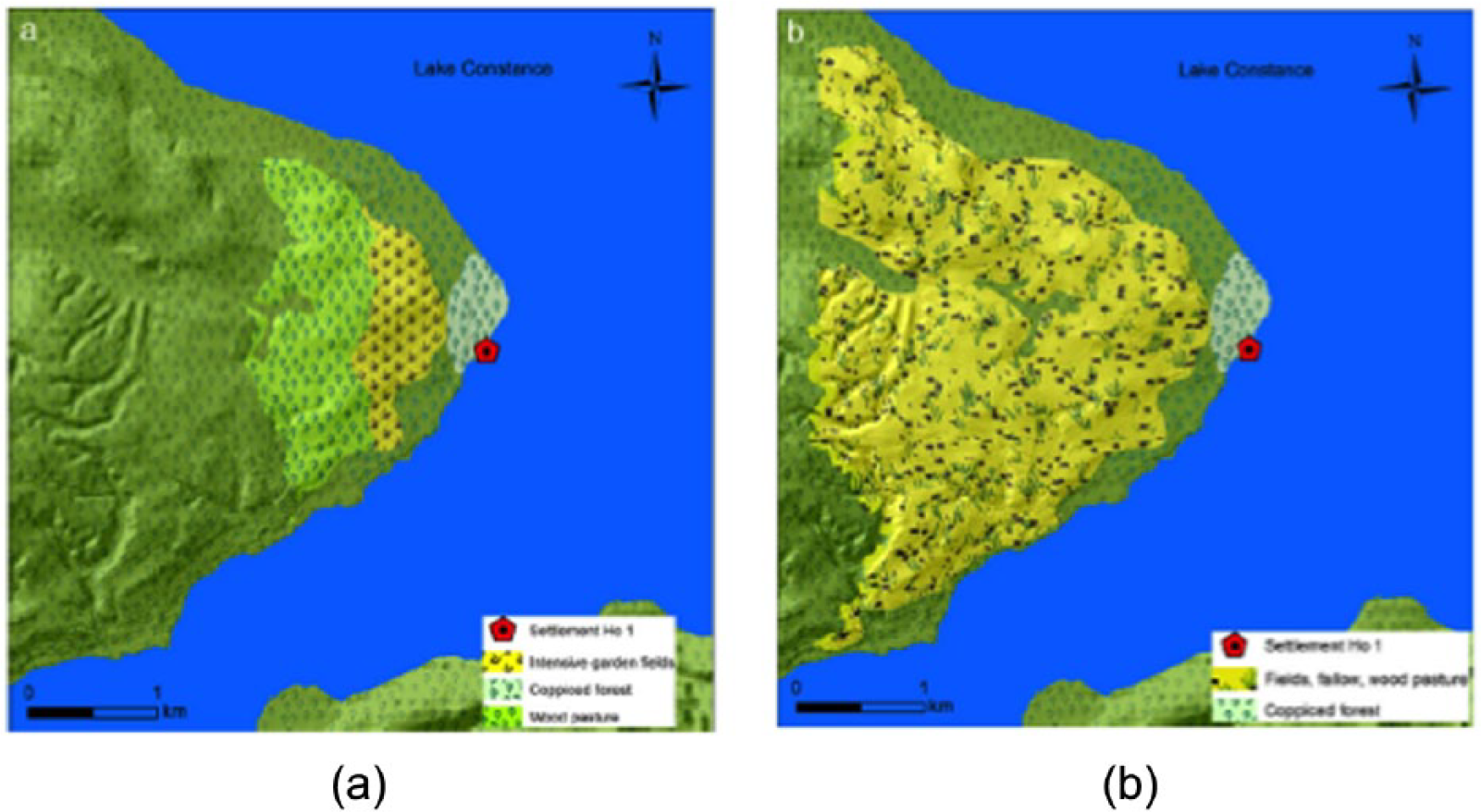
Possible amounts of open and shrubby land around a late Neolithic settlement (Hornstaad Hörnle I, Lake Constance, 3918–3905 cal. BC). Modelling attempt based on (a) permanent fields with intensive cultivation (left) and (b) the existence of slash-and-burn cultivation (shifting cultivation; from Baum, 2014).
Modelling approaches have the potential to open up wider archaeological perspectives on the practices and impacts of early agrarian societies (Whitehouse and Kirleis, 2014). Moreover, the results can be incorporated into land cover simulations on a larger scale, for example, of the early Anthopocene (Ellis et al., 2013; Kaplan et al., 2009, 2011; Ruddiman, 2004, 2013; Ruddiman et al., 2011). For all this, it is crucial to bring together – in an integrative way – as many types of palaeoenvironmental proxies as possible in order to gain more plausible insights into the landscapes that existed thousands of years ago. We believe that this article contributes to this goal.
As a final offering, we propose to re-write the conclusions of Lechterbeck et al. (2014): ‘Some very elaborate land use models based on experimental data suggest that the expansion of secondary forest elements was caused by “slash and burn” or “swidden” cultivation (Rösch, 2013; Schier et al., 2013)’ (p. 108). A more appropriate formulation, based on a comprehensive knowledge of on-site data, would be, ‘The expansion of secondary forest elements was caused by different landscape management practices which included the use of fire’.
Supplemental Material
sj-pdf-1-hol-10.1177_0959683616645941 – Supplemental material for On-site data cast doubts on the hypothesis of shifting cultivation in the late Neolithic (c. 4300–2400 cal. BC): Landscape management as an alternative paradigm
Supplemental material, sj-pdf-1-hol-10.1177_0959683616645941 for On-site data cast doubts on the hypothesis of shifting cultivation in the late Neolithic (c. 4300–2400 cal. BC): Landscape management as an alternative paradigm by Stefanie Jacomet, Renate Ebersbach, Örni Akeret, Ferran Antolín, Tilman Baum, Amy Bogaard, Christoph Brombacher, Niels K Bleicher, Annekäthi Heitz-Weniger, Heide Hüster-Plogmann, Eda Gross, Marlu Kühn, Philippe Rentzel, Bigna L Steiner, Lucia Wick and Jörg M Schibler in The Holocene
Footnotes
Acknowledgements
This study was conducted partly within several projects of the SNF (Swiss National Foundation), mainly project no. K-13K0-117897 (The role of Animal Fodder in Neolithic and Bronze Age Subsistence Economy and its Palaeoecological Implications), and the currently running project no. CR30I2_149679 (Formation and Taphonomy of Archaeological Wetland Deposits: Two Transdisciplinary Case Studies and their Impact on Lakeshore Archaeology). Information was also provided by the ongoing SNF project CR12I2_143815/1 on Sr87/Sr86 isotope analyses (PI: J Schibler). We also thank the canton und town of Zürich who have funded former investigations and especially the ongoing research on the recently excavated site of Zürich Parkhaus Opéra. The first author thanks Angela Kreuz (Landesamt für Denkmalpflege Wiesbaden, Germany) for her valuable comments on an earlier version of this article. We also thank Urs Leuzinger (Amt für Archäologie des Kantons Thurgau) for information on finds of ards and ardmarks, and Manfred Rösch who kindly provided unpublished data (Mainau diagram). Finally, we thank two anonymous reviewers whose comments enabled us to make the text much more concise, and Madeleine Hummler for help with our English wording.
Funding
The author(s) received financial support for the research, authorship, and/or publication of this article by the sources mentioned in the acknowledgements.
Supplemental Material
Supplemental material for this article is available online.
References
Supplementary Material
Please find the following supplemental material available below.
For Open Access articles published under a Creative Commons License, all supplemental material carries the same license as the article it is associated with.
For non-Open Access articles published, all supplemental material carries a non-exclusive license, and permission requests for re-use of supplemental material or any part of supplemental material shall be sent directly to the copyright owner as specified in the copyright notice associated with the article.