
Abstract
Recent archaeological investigations at the site of Colombier/Les Plantées de Rive (COL-PR) on the northwestern shore of Lake Neuchâtel (Switzerland) revealed an exceptional concentration of anthropic structures from the Late Neolithic to the Late Bronze Age interbedded within an alternation of terrestrial and lacustrine deposits. The chronology is based on radiocarbon dates from terrestrial material and on artefacts found in archaeological structures. Using various proxies, the sedimentological analysis of the COL-PR sediment sequence allows the reconstruction of lake-level fluctuations for the period 4900–3300 cal. BP. Three major lake-level highstands occurring at ca. 4900 (Late Neolithic), 3650 (Early Bronze Age) and 3400 cal. BP (Middle Bronze Age) have been related to the possible influences of decreases in the solar activity sometimes accentuated by increases in volcanic activity. The COL-PR site provides robust data to document the climatic deterioration assumed to be responsible for the abandonment of the lake-dwellings north of the Alps during the Middle and the early Late Bronze Age. In addition, the interbedding of successive monuments within terrestrial as well as lacustrine deposits suggests a significant role played over hundred years by the collective memory in the perpetuation of the ceremonial and funeral vocation of the site and its spatial organisation at the interface between lacustrine and terrestrial domains, despite interruptions provoked by major lake-level rises associated with worsening of climatic conditions.
Keywords
Introduction
The lakes located in West-Central Europe have undergone recurrent multi-centennial scale water-level fluctuations during the entire Holocene. On a regional scale, these lake-level variations have been shown to attest synchronous changes that occurred in response to a possible combination of three main forcing factors, that is, orbitally driven changes in insolation, impacts of deglacial outbursts and variations in solar activity (Bleicher, 2013; Chiverell et al., 2011; Magny, 2004a, 2004b, 2006, 2013; Solomina et al., 2015).
During the period from 4300 to 850 BC, the shorelines of numerous lakes of the Jura Mountains and the Swiss Plateau were regularly occupied by prehistoric settlements, known as lake-dwellings or ‘palafittes’. Consequently, a robust chronological framework has been established on the basis of multiple tree-ring sequences for these Neolithic and Bronze Age lake-dwellings north of the Alps. On the basis of a comparison between the frequency of prehistoric lake-dwellings with the residual atmospheric 14C record (Magny, 1993, 2004b, 2013), it has been proposed as a working hypothesis that phases of higher solar activity induced warmer and drier climate conditions and lake-level lowering which, in turn, favoured the multiplication of such settlements. Altogether, these studies point to the possible impact of multi-centennial climatic variations not only (1) on the location of Neolithic and Bronze Age villages with major phases of higher lake-level conditions and lake-dwelling abandonment at ca. 5490–5360 cal. BP (end of the Middle Neolithic), ca. 4350–4050 cal. BP (Late Neolithic), ca. 3450–3050 cal. BP (Middle Bronze Age) and ca. 2800 cal. BP (end of the Bronze Age) but also (2) on the subsistence strategies of the first agropastoral societies north of the Alps (Arbogast et al., 2006; Magny, 2015; Magny et al., 2006, 2009; Menotti, 2015; Pétrequin et al., 2006).
Among the many lakes studied north of the Alps, the shores of Lake Neuchâtel, one of the largest of the Swiss Plateau, have been the object of many archaeological and palaeoenvironmental investigations since the 19th century (Arnold, 2009, 2012). These studies were triggered by the presence and exploration of the numerous prehistoric lake-dwellings spanning the period of 3880–850 BC (i.e. 5830–2800 cal. BP). They permitted the reconstruction of the water-level fluctuations of Lake Neuchâtel for the Neolithic and the Bronze Age and the tentative assessment of their magnitude (e.g. Arnold and Langenegger, 2012; Brochier and Moulin, 2010; Campen and Kurella, 1998; Lüdi, 1935; Magny, 2008; Magny et al., 2005; Moulin, 1991; Schifferdecker, 1982).
Recent archaeological investigations in 2013 at the site of Colombier/Les Plantées de Rive (hereafter COL-PR) revealed an exceptional concentration of anthropic structures spanning from the Late Neolithic to the Late Bronze Age (Wüthrich, 2014) interbedded within an alternation of terrestrial and lacustrine deposits. Thanks to its relatively elevated topographic position compared with the long-term mean water level of Lake Neuchâtel, the site of COL-PR offers a unique opportunity to observe the sedimentary imprints of major rises in lake level over the period of ca. 5250–2800 cal. BP and more particularly to better document the Middle Bronze Age period around 3300 cal. BP which corresponds to a major phase of regional high water level leading to an abandon interval of the protohistoric lake-dwellings north of the Alps lasting until the reoccupation of the lakeshores in the Late Bronze Age (Magny, 1993, 2004a, 2004b, 2013; Menotti, 2015).
Study site
The site of COL-PR is located on the northwest shore of Lake Neuchâtel, in the bay of Auvernier, situated between the alluvial deltas of the Areuse River to the southwest and the Ruz Chatru River to the northeast. The bay is also supplied by two brooklets close to the site (Figure 1). Today, Lake Neuchâtel has a surface of about 214.6 km2, with a maximum length of 38.3 km and an average width of 5.96 km. Its maximum depth is 153 m. The present-day lake level has been regulated by extensive hydro-engineering works, known as the ‘corrections of the Jura waters’, which took place between 1868–1891 and 1962–1973 (Nast, 2006). Based on data measured since 1983, the average lake level today is situated between 429.3 and 429.5 m a.s.l. with fluctuations between 428.9 and 430.5 m a.s.l. Before the regulation works, during the time span of 1817–1869, the average lake level was at 432.07 m a.s.l., with minima and maxima situated at 431.01 and 433.35 m a.s.l., respectively (Brochier and Hadorn, 2010). The actual drainage basin measures 2670 km2, with an average altitude of 780 m a.s.l., the maxima being at 1680 m a.s.l.
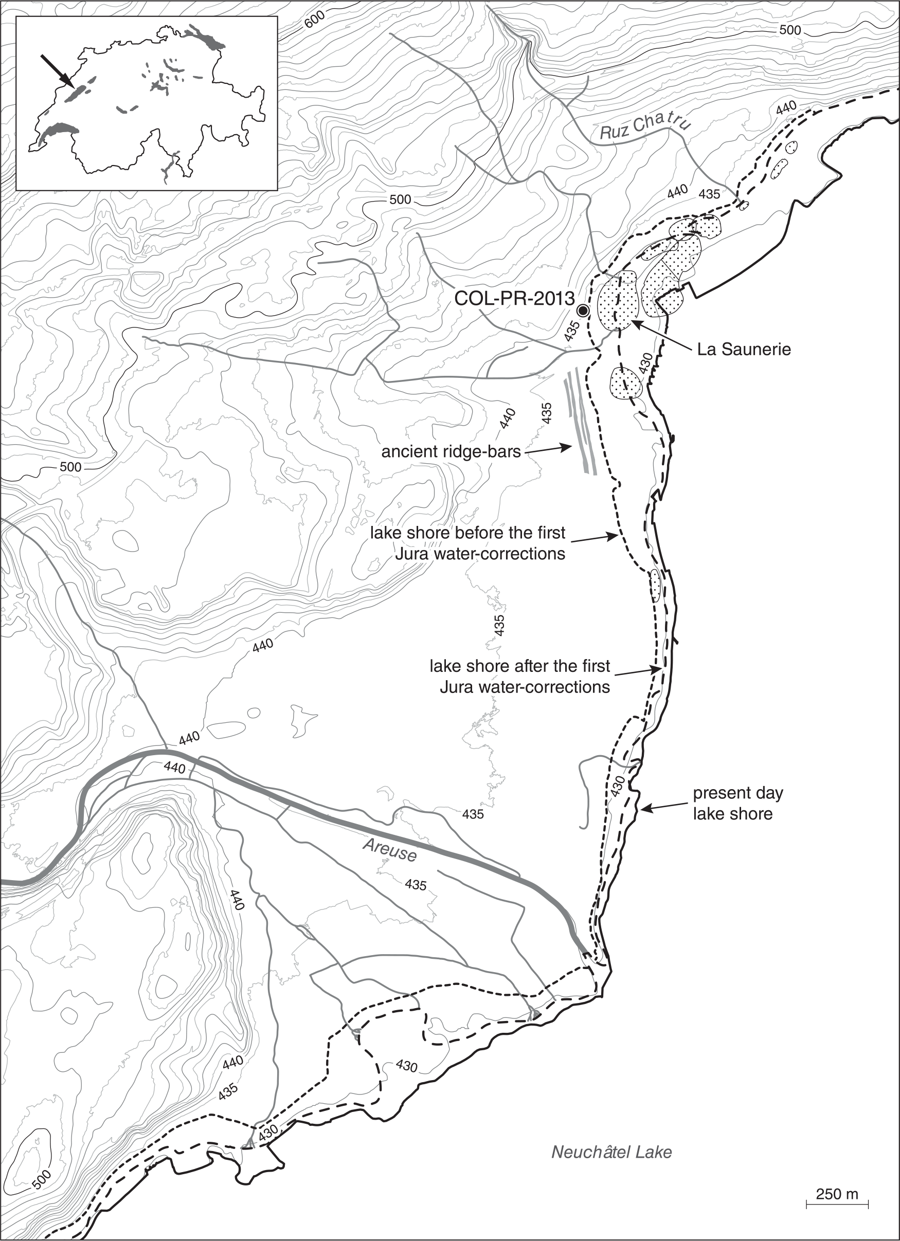
Location of the studied site (upper panel) in its geographical and archaeological context (lower panel). The dotted areas indicate the main lake-dwelling sites known in the surroundings of the COL-PR site.
From the geological point of view, the studied area is located at the contact between the limestone substratum of the Jura Mountains and the Tertiary molassic basin (Swiss Plateau) built up of sandstones and marls. During the last glaciation, the region was covered by the Rhône Glacier responsible for the deposition of moraines, glaciofluvial and glaciolacustrine sediments. At the level of the studied site, the lake deposits are eroding glaciofluvial and glaciolacustrine sediments (Letessier, 2004; Meia et al., 1971). The regional climate is characterised by a mean annual temperature of ca. 9.2°C, a mean annual precipitation of around 1000 mm, while the annual evapotranspiration is 573 mm; thus, on a yearly scale, leaching conditions prevail (Baniewicz, 2004; Meteoschweiz, 2005).
The bay of Auvernier is well-known for its numerous prehistoric lake settlements covering discontinuously the time span of 3790–850 BC, that is, 5740–2800 cal. BP (Arnold, 2009). Among these, the site of Auvernier/La Saunerie, located some 150 m lakewards from the site of COL-PR (Figure 1), was occupied during at least three phases of the Neolithic, tree-ring dated to 3637–3597 BC, 2784–2701 BC and 2634–2434 BC (Arnold, 2009). In addition, a single-chamber megalithic tomb dating to the Late Neolithic was fortuitously discovered in 1876 during construction work (Desor, 1876; Gross, 1876). Such funerary structures, also known as dolmens, were erected between the end of the fourth millennium and throughout the third millennium BC (Pétrequin and Piningre, 1976). Archaeological investigations were carried out in 2013 prior to construction work on the parcel of land where the dolmen was found. This survey revealed the leftovers of the 1876 dolmen excavations and also new archaeological features, namely, (1) a megalithic monument built during the Late Neolithic (one short alignment of standing stones), (2) a Middle Bronze Age funerary complex (composed of an inhumation under a tumulus, accompanied by one flat grave and an incineration) and (3) two Late Bronze Age fireplaces (Wüthrich, 2014; Figure 2). This exceptional concentration of archaeological finds was interbedded within a sediment sequence giving evidence of an alternation of lacustrine and terrestrial/colluvial deposits, which instigated the interdisciplinary geoarchaeological research presented here.

Photographic view and map of the site of Colombier/Les Plantées de Rive (COL-PR). (a) View of the archaeological excavation. ST.8, Late Neolithic megalithic stone alignment (visible on the middle panel); ST.1, Middle Bronze Age tumulus; ST.3, Middle Bronze Age incineration structure; T.2, Middle Bronze Age flat tomb; and ST.2 and ST.4, Late Bronze Age combustion structures. (b) General map of the site with the location of the archaeological structures and the main stratigraphic sections. Thick lines: location of the main stratigraphic sections. The black arrow indicates the location of the section illustrated on the lowest panel. Light grey area: location of the house constructed previously on the excavated zone; the archaeological remains are obliterated in this area. Dark grey areas: location of the archaeological structures mentioned in this paper (see above for details). (c) Photographic view of the section indicated by a black arrow in (b). 1, 2, … 16 are the layer numbers as discussed in the text.
Methods
The archaeological excavations were accompanied by systematic sedimentological and pedological observations both on vertical and horizontal surfaces. The superposition of the archaeological structures and technical restrictions did not allow continuous stratigraphic sections (Figure 2). Thus, the succession of the layers was often unravelled by the combination and correlation of several stratigraphic sections: in total, some 70 stratigraphic profiles were observed, described and sampled. The sedimentary (granulometry, stratification, spatial distribution) and soil characteristics (organic horizons, structuration, bioturbation, secondary carbonates) were carefully recorded for each delimited layer in several reference profiles. This allowed us to document the lateral variability of the features and to correlate the stratigraphic units. The coarse fraction was determined by wet sieving. The other analyses were performed following the standard procedures as follows. The granulometry of the fine fraction (<2 mm) was analysed by laser equipment LS230_Coulter Beckmann. The organic carbon content was determined by the Walkley and Black method, while the CaCO3 content was measured by the calcimeter (Mathieu and Pieltain, 2003). The undisturbed soil samples were impregnated under vacuum by polyester resin and cut into 30-µm-thick sections. These were described according to the standard terminology (Stoops, 2003). Large sediment samples (1–3.5 kg according to the granulometry) were wet sieved on a set of 2–1–0.5–0.2 mm sieves in order to recover the mollusc shells. Several selected samples were briefly screened to determine the presence/absence of terrestrial and freshwater species (Deák and Thew, 2015).
The differentiation of the flood (lake or river) and terrestrial (colluvial) deposits and the unravelling of the importance of the subsequent pedogenesis were essential elements of our research. In a first step, the granulometry, the morphology of the layers as well as the presence/absence and the proportion of aquatic and terrestrial mollusc species were the arguments used to interpret the origin of the sediments. Second, we integrated the field observations and laboratory evidences of soils and sediments investigated in the studied region (Bednarz et al., 2006; Elmer et al., 2016; Havlicek et al., 2003). According to these, the fine-textured (<2 mm) components of the layers stemming from inundations are strongly calcareous, while those which were deposited by colluvial processes from the neighbouring slopes are non-calcareous. Last but not least, we had to deal with the fact that in the leaching conditions of the studied region, the CaCO3 of originally calcareous sediments may become partially or totally leached during pedogenesis. To summarise, the following features are the elements used to point out in situ pedogenetic processes: (1) bioturbation and structuration observed in the field and under the microscope and (2) the upward increase in the organic matter content in parallel with the downward decrease in the CaCO3 content.
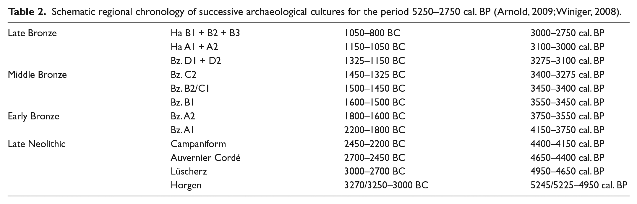
The chronological background was established based on the radiocarbon dates provided by the charcoal and cremated bones found both in the studied layers and in the archaeological structures. The typology of the finds found in the prehistoric structures gave additional chronological support. Taking into consideration the archaeological context of the site, the 2σ calibrated BC dates are used in this article. The chronological setting of various lake-dwelling settlement layers cited below is based on the dendrochronological dating of piles.
The reconstruction of past lake-level fluctuations and the tentative assessment of their magnitude are based on observations of the various present-day lake sediments and their depositional environments along the lakeshore of the studied region (e.g. the bays of Auvernier and Bevaix). In addition, we also took into account the sedimentary dynamics of recent deposits accumulated in response to the corrections of the Jura waters (Meia et al., 1971). Thus, the formation of ridge-bars (or gravelly raised beach deposits) composed of heterometric gravels and pebbles appears to be associated with storms occurring during seasonal high water levels (today at 430 m a.s.l.). The accumulation of rounded coarse sands and fine gravels corresponds to beach deposits in equilibrium with the mean annual water level (today at 429.3/429.5 m a.s.l.), whereas carbonate lake marl characterises an open-water sedimentation in areas generally under the mean water level or only exceptionally emerging during the late autumn and sometimes winter lowest water-level conditions (today at 428.9 m a.s.l.) in areas close to the shore. While the seasonal lake-level variations today reach 1.6 m, the natural seasonal fluctuation before the artificial regulation was at least 2.4 m as measured over the period of 1817–1869, with highstand up to 1.3 m above the mean annual lake-level, and seasonal lowering to ca. 1.1 m below the mean annual lake level.
Results
The sedimentary sequence of COL-PR site
The stratigraphic sequence discussed here is characterised by a succession of gravelly layers alternating with sandy-silty deposits. Seventeen layers, labelled L.1–L.17, were distinguished. As exposed and reasoned here below, they are either lakeshore deposits or sediments resulting from a combination of fluviatile and slope erosion/sedimentation processes. Based on the dominant depositional processes responsible for their accumulation, the layers have been grouped into seven sedimentary phases, labelled from A to G. The stratigraphic data, the sedimentological observations and the analytical data are presented in Figures 3 and 4 and Tables 1–3.
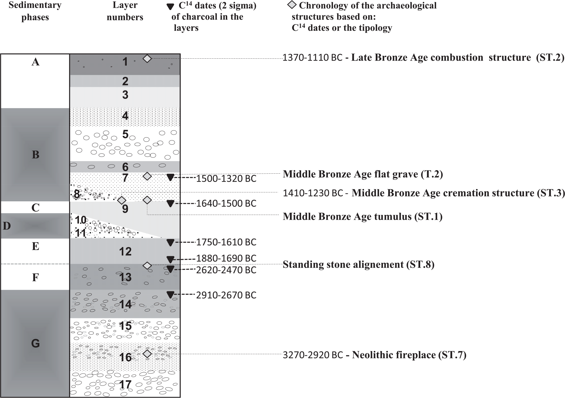
Stratigraphic succession and chronological setting of the studied layers at the COL-PR site. In this figure, the C14 dates indicated are the rounded up values of those measured. The precise details of the radiocarbon dates are presented in Table 1, while the sedimentological descriptions are presented in Table 3. The sedimentary phases composed of lake sediments are highlighted in grey.
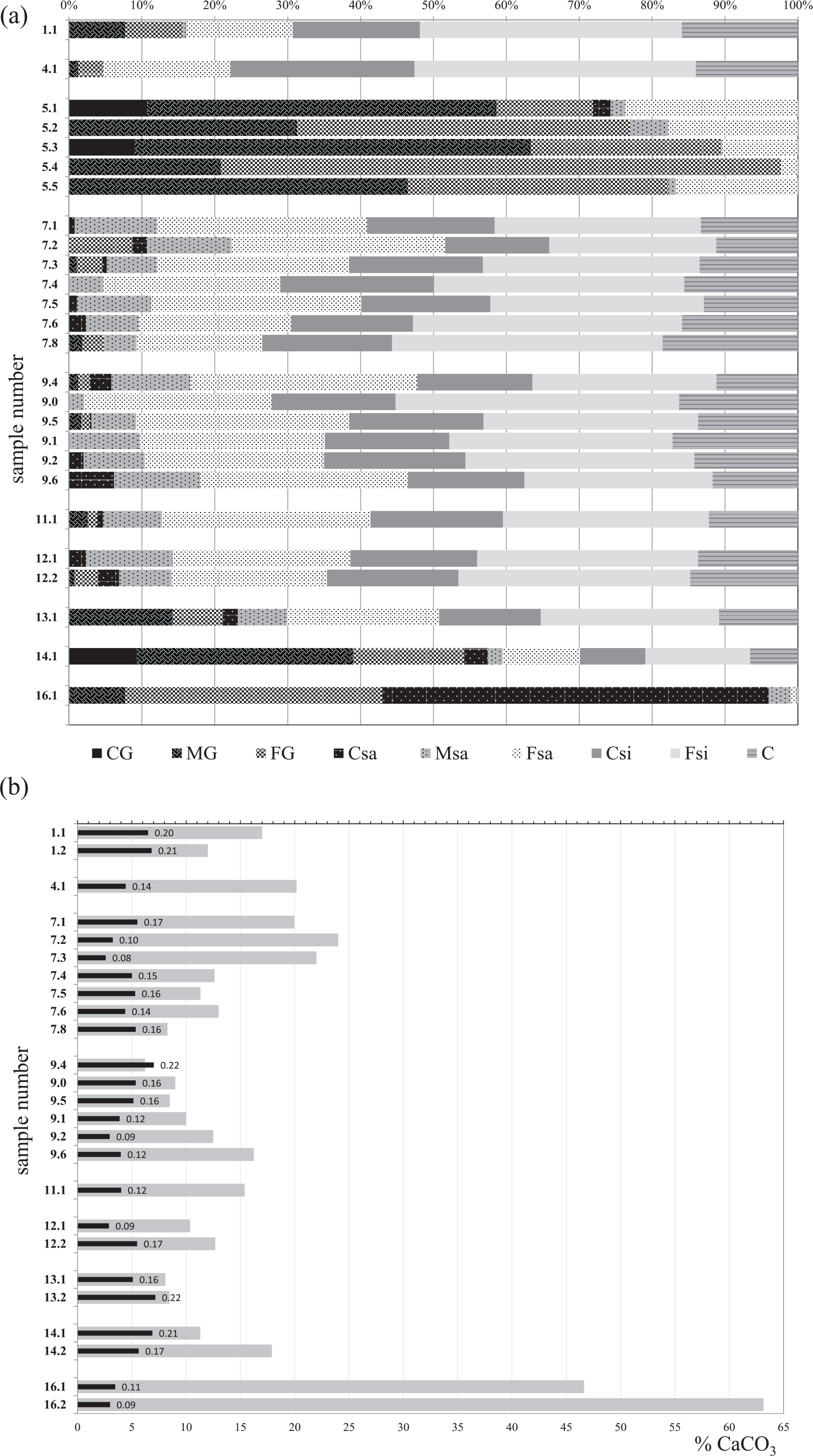
Sediment and soil characteristics based on analytical data. (a) Grain-size distribution. CG: coarse gravel (40–31 mm); MG: medium gravel (31–10 mm); FG: fine gravel (10–2 mm); CSa: coarse sand (2000–500 µm); MSa: medium sand (500–200 µm); FSa: fine sand (200–50 µm); CSi: coarse silt (50–20 µm); FSi: fine silt (20–2 µm); C: clay (<2 µm). Sample number: for example, 7.1 = layer 7, sample 1. (b) Variation in the organic carbon and CaCO3 content. Light grey bars: CaCO3 content of the individual samples. Black bars with values: organic carbon content of the individual samples. Analyses performed by the Soil Science Laboratory of the Strasbourg University (France).
Radiocarbon dates obtained from the COL-PR sediment sequence.

Radiocarbon dates measured by the Ion Beam Physic Laboratory of Zürich.
Schematic regional chronology of successive archaeological cultures for the period 5250–2750 cal. BP (Arnold, 2009; Winiger, 2008).
Sediment and soil characteristics based on field observations and malacological screening.

d: diameter; HCl: intensity of reaction with HCl (1 = weak; 2 = strong; 3 = very strong); T: maximal thickness of the layer; A: altitudes of the upper part; a: altitudes of the lower part; malacofaune (based on Deák and Thew, 2015): the figures indicate the number of species identified; A: aquatic species; M: marshy species; Tt: terrestrial tolerant species; To: terrestrial open landscape species; Tsh: terrestrial shade tolerant and forest species; Tf: terrestrial mature forest species; n.a.: no analyses.
If the layer was observed in several parts of the site or over larger distances, the range of the documented altitudes is given (e.g. A = 434.00/434.20 m means that the upper part of this layer has been observed between 434.00 and 434.20 m).
The recognition of lake sediments was one of the guiding threads of fieldwork and laboratory investigations. Several gravel-rich deposits were identified on-site. These layers are only present along the lakeside part of the site and they are wedging out upslope. Based on our lakeshore observations and former sedimentological record (Meia et al., 1971), we deduce that they are witnessing former lakeshore ridge-bars. The field and analytical characteristics of these gravelly sediments are presented in the first part of section ‘Environmental significance of the gravelly layers’. Interbedded with gravelly deposits, several more or less homogeneous and strongly similar, finer textured layers are also part of the sedimentary sequence. The understanding of the environmental significance of these sandy-silty deposits required a combination of field and micromorphological observations completed by sedimentological and malacological analyses, the results of which are presented below in section ‘Environmental significance of the silty-sandy layers’.
Environmental significance of the gravelly layers
Taken together, the sedimentological characteristics (Table 3 and Figure 3) of L.17-16-15-14, forming sedimentary phase G, indicate sediment deposition on a former lakeshore. They testify that during their deposition the lakeshore was close to the topographic position of the site. Consequently, they witness a high lake-level phase.
L.17 corresponds to a former, gravelly ridge-bar, thus pointing to sediment deposition by storms during high water levels. The overlying loose, coarse sandy and rounded fine gravelly L.16, sometimes composed of several more or less distinct strata, suggests a beach deposit corresponding to a mean water level, thus an increase in the lake-level rise. Indeed, the loose nature of the deposit, the rolled morphology of the gravels and the only sporadic presence of the CaCO3 crusts observed in thin sections, the latter typical for sediments deposited under the mean water level (Magny, 2006 and personal observations), indicate a depositional environment dominated by wave action. The exclusively freshwater and fragmented mollusc shells recognised in this layer support this interpretation (Table 3).
L.15 was observed only on the landward part of the area affected by these lakeshore deposits. The loose gravelly composition and the distal position compared with the lakeshore indicate major storms during highest lake water–level periods.
L.14, by its coarse fraction, suggests once more a raised beach formation during the last part of this lake-level rise phase. Hence, it was deposited during high water levels while the mean water level was retreating. Its bimodal composition suggests an additional fine sediment deposition (floods depositing fine material, but possibly also some colluvium from the neighbouring slopes) during and/or after episodes of lake retreat.
The thickness (at least 60–80 cm) of the sediments of phase G suggests a deposition during an important lake-level rise event. The upper part of these deposits (L.14) has undergone a significant pedogenesis with an at least seasonal low water-table as indicated by the pedofeatures observed in the field and in the thin sections and the analytical data such as the humiferous and partially decalcified nature of the fine soil material, the bioturbation, the evidence of earthworm activity, the formation of secondary CaCO3 accumulations and the presence of both aquatic and terrestrial molluscs (Table 3 and Figure 4). The traces of a radiocarbon-dated fireplace (ST.7) found in L.16 suggest that this layer accumulated around 3270–2920 BC (ETH-54039), thus during the archaeological period of Horgen or the beginning of Lüscherz (Tables 1 and 2). Moreover, a radiocarbon-dated charcoal stemming from L.14 suggests that the pedogenetic processes affecting these deposits were active at least until 2910–2670 BC (ETH-54053), thus approximately during the Lüscherz period (Tables 1 and 2). Further details of the chronological aspect will be discussed below in section ‘The Lake Neuchâtel water-table variations reconstructed from the site of COL-PR in comparison with data obtained from previous research studies’.
The gravelly and the sandy layers L.10 and L.11, forming the sedimentary phase D, are lakeshore sediments deposited during severe storms as indicated by their coarse granulometry, their presence only along the lakeside part of the site and the landward wedging out morphology (Table 3). Moreover, their depositional altitudes suggest high lake water levels reaching the topographic position of the site, between ca. 433.00 and 433.50 m a.s.l. The mollusc assemblage of L.11, rich in aquatic species and also containing marshy and terrestrial indicators, bears witness to the transitional sedimentary setting between the terrestrial and lacustrine domains. The stratigraphic position suggests that these high waters reached the site during the Early Bronze Age. This occurred (Figure 3) (1) after the deposition of L.12, containing charcoals dated to 1876–1693 BC for its lower part (ETH-60920) and 1750–1610 BC for its upper part (ETH-54058), and (2) before the deposition of L.9, containing charcoal dated to 1642–1500 BC (ETH-54060 and 60921). All these sediments (L.12, 11, 10, 9) precede the construction of the Middle Bronze Age tumulus (ST.1).
L.8, representing the lower part of sedimentary phase B, has been recorded only on very limited, lakeside parts of the site. This, together with its coarse granulometry (Table 3), again suggests deposition by storms during a short phase of lake-level rise. It is eroding L.9 (see above and Figure 3). One of the construction elements of the Middle Bronze Age incineration structure (ST.3), radiocarbon dated to 1500–1405 BC by charcoal (ETH-54045) and 1410–1230 BC (ETH-54046) by a cremated bone (Tables 1 and 2), was cut into this layer. It is covered by the silty-sandy L.7 into which the Middle Bronze Age flat tomb (T.2) was dug (Figure 3). To conclude, this lake-level rise, reaching the topographic position of the site, occurred during the Middle Bronze Age, before the implantation of the incineration (ST.3). Therefore, together with L.7, it marks the first phase of a major period of high lake water level culminating in the deposition of L.5 (Figure 3).
The last and the most important phase of high lake water level is materialised by the gravelly deposits of L.5. The thickness of this sediment is remarkable (up to 50 cm), and although it is wedging out upslope, it could be followed along the entire width of the investigated area. The morphology and the spatial distribution of this layer, its coarse granulometry and its mostly aquatic, above mean lake water level, malacological assemblage (Table 3 and Figure 4a) indicate gravel deposition along the lakeshore because of storms during high water levels. This layer covers the Middle Bronze Age incineration structure (ST.3; see above and Figure 3). It is covered by several layers of sandy-silty sediments (L.4–L.1, Figure 3). Anthropic activity at the uppermost part of these deposits is clearly indicated by two combustion structures (ST.2 and ST.4). The radiocarbon dates provided by ST.2 suggest a deposition of these layers before 1370–1110 BC (Figure 3 and Tables 1 and 2, ETH-54049 and 54050). Thus, the lake-level rise recorded by L.5 occurred during the second part of the Middle Bronze Age.
Environmental significance of the silty-sandy layers
The gravel-rich deposits, indicating phases of high lake level, are interbedded with silty-sandy layers (Figures 3 and 4a), bearing traces of more or less important soil-forming processes which suggest intermediate periods of lower lake level. In the absence of eroding coarse sediments, these layers are often fairly similar in outcrops. In this case, they have been differentiated on the basis of soil characteristics (stabilisation surfaces) and interbedded archaeological structures (Figure 3). These silty-sandy layers compose partially or totally the deposits of the sedimentary phases F (L.13), E (L.12), C (L.9), B (L.7 and L.4) and A (L.3, L.2, L.1). Given that several of their characteristics are similar, a comparative overview of them is presented before an interpretation of the environmental significance of the successive layers.
Sedimentological analyses indicate similar grain-size distribution in these silty-sandy layers (Figure 4a). With the exception of L.13 and L.1 (see below), they (L.12, L.9, L.7, L.4, L.3, L.2) are characterised by the absence (or minor presence) of more than 2 mm components. Based on field observations, we interpret the presence of gravels in these layers, L.13 and L.1, as related to the reworking of the overlying and underlying coarser deposits during sedimentation. In addition, the subsequent bioturbation processes also contributed to the vertical dislocation of these coarse elements as suggested both by the field and micromorphological observations.
According to micromorphological observations, all these layers are strongly bioturbated and only rare traces of micro-stratifications could be noted. Traces of oxydo-reduction processes were observed in all of the layers, but they are more frequent in L.7. The presence of secondary CaCO3 accumulations has been noted in L.13, L.12, L.9 and L.7. They indicate an environment characterised by a seasonal excess of evapotranspiration over precipitation.
In the field, all these layers strongly react with HCl. However, laboratory analyses indicate a CaCO3 content varying from 6% to 24% (Figure 4b). These values are rather low compared with the up to 40–70% calcite content measured in the prehistoric sediments of the neighbouring alluvial plain of the Areuse River (Elmer et al., 2016). According to micromorphological observations, the fine material of all the layers analysed at the site of COL-PR is partly composed of non-calcareous sediments. The decalcified fine material can be explained by leaching associated with pedogenetic processes. The organic matter increase coupled with CaCO3 decrease trends (Figure 4b) for L.9 and L.1 are arguments for leaching associated with a stabilisation phase. However, the relatively short duration of pedogenesis (maximum a few hundred years) cannot explain the relatively low CaCO3 values all over. Moreover, the simultaneous presence of non-calcareous soil fragments and the in situ secondary CaCO3 accumulations observed in the thin sections, the latter witnessing an at least seasonal non-leaching environment, argue for a non-calcareous sediment source in the deposition of these sediments. Thus, these silty-sandy soil sedimentary units appear to be the result of the combined deposition of calcareous sediments and a humiferous weakly or non-calcareous material. In the studied context of the COL-PR site, regular flooding could be at the origin of the calcareous sediments, while the erosion of the decalcified soils from the surrounding slopes and their deposition by colluvial processes provided the second component of the deposits. The presence of both freshwater and terrestrial molluscs (Table 3) in all these layers supports the above-formulated hypothesis. Given the location of the site, the origin of the floods can be either the lake (exceptional storms) or the river, or both. The available data do not permit an evaluation of the altitude of the mean lake level on the basis of the altitudes of these layers. To further discuss their significance, they will be confronted (see section ‘The Lake Neuchâtel water-table variations reconstructed from the site of COL-PR in comparison with data obtained from previous research studies’) with the existing knowledge concerning the lake-variation trends and the mean water levels proposed by these former research works.
The above-presented sedimentary and soil characteristics, the stratigraphic observations and the available radiocarbon dates suggest the following interpretation of these silty-sandy layers.
L.13 with its rather high coarse-element content (about 21%; Table 3 and Figure 4a) is interpreted as the local reworking of the underlying L.14. The high variety and well-preserved aquatic molluscs indicate a strong influence of flooding in its deposition. The upward-decreasing organic carbon content (Figure 4b) suggests that its humiferous nature is at least partially related to the reworking of the underlying L.14. Nevertheless, this layer has also undergone in situ pedogenetic processes, of which the presence of molluscs suggesting forest environment (Table 3) and the bioturbation are the main traces. This layer also bears traces of burning activity radiocarbon dated to 2620–2470 BC (ETH-54056, Auvernier Cordé) and it was deposited after L.14 radiocarbon dated to 2910–2670 BC (ETH-54053) from a charcoal taken in its upper part (Figure 3 and Tables 1 and 2). Hence, we conclude that L.13 was deposited and evolved at the surface at least during the archaeological period of Auvernier Cordé (see also section ‘The Lake Neuchâtel water-table variations reconstructed from the site of COL-PR in comparison with data obtained from previous research studies’).
The next two fine-textured sediments, L.12 and L.9, are both dominated by the sandy-silty fractions (Figure 4a). On the basis of their homogeneous and slightly humiferous nature, the absence of stratification and the bioturbations observed in the field and in thin sections, they are interpreted as slowly accumulating sediments on a vegetated surface. The common presence of molluscs indicating short vegetation and open environment is in good agreement with this hypothesis. This relatively calm depositional environment was interrupted by a short period of high lake level reaching the site (sedimentary phase D, that is, L.11 and L.10). In the second part of the soil sedimentary accumulation materialised by L.9, there are evidences of decreasing frequency of the sediment input and a period dominated by pedogenetic processes. This is witnessed by (1) an important bioturbation, (2) an increasing organic carbon content coupled with a decreasing CaCO3 trend (Figure 4b) and (3) a diversification of the mollusc species (Table 3). This relatively stable soilscape was chosen for the construction of the Middle Bronze Age tumulus (ST.1), and after a short lake-level rise affecting only a limited part of the area (L.8), the Middle Bronze Age incineration structure (ST.3) was also installed on this soil. L.12 was deposited and evolved at the surface during the Early Bronze Age as indicated by the radiocarbon dates of the charcoal from its lower and upper parts (Figure 3 and Tables 1 and 2). Based on its stratigraphic position and the available radiocarbon dates, the sedimentary and pedogenetic processes recorded by L.9 can be dated between the final part of the Early Bronze Age and the beginning of the Middle Bronze Age (Figure 3 and Tables 1 and 2), preceding the construction of the Middle Bronze Age tumulus (ST.1).
L.7 is slightly coarser than the underlying layer L.9 (Figure 4a), its CaCO3 content is among the highest values obtained from the sandy-silty layers of the COL-PR sediment sequence (Figure 4b) and is rich in aquatic mollusc species (Table 3). It is also characterised by landward finer (Figure 4a: sp. 7.6, 7.8 vs sp. 7.5) and upward-coarsening granulometric trends (Figure 4a: sp. 7.1, 7.2, 7.3 vs sp. 7.5). It bears traces of bioturbation, but the pedogenetic processes did not have sufficient time to create a perceptible horizon differentiation. It is interpreted as a flood deposit in a high lake water-level context. The common traces of oxydo-reduction processes sustain the hypothesis of seasonally high water-table environment. Nevertheless, in comparison with the periods recorded by the underlying and overlying layers (L.8 and L.5), the mean lake water level during the deposition of this layer was somewhat lower and seasonal drying out may have been common, as suggested by (1) the granulometry (Figure 4a), (2) the bioturbation observed in the field and in thin section and (3) the earthworm biospheroids and secondary CaCO3 accumulations revealed by micromorphological observations. This layer covers two Middle Bronze Age inhumation structures (ST.1 and ST.3), while a third one (T.2) is cut into it. Consequently, it is interpreted as a layer deposited during the Middle Bronze Age, more precisely dating after 1410–1230 BC (ETH-54046, Figure 3 and Tables 1 and 2).
Similarly to L.7, L.4 is sandy-silty, its CaCO3 content is among the highest of the COL-PR sedimentary sequence and it is rich in aquatic molluscs. These evidences suggest that this layer was also predominantly deposited by floods. It covers the lakeshore deposits of L.5 dated to the Middle Bronze Age (Figure 3). Therefore, its deposition appears to be the last imprint of the sedimentary dynamics governed by Middle Bronze Age high lake water levels.
L.3, L.2 and L.1 postdate the sediments witnessing the Middle Bronze Age high water levels and have been grouped in the sedimentary phase A. Their accumulation resulted from variable amounts of flood and/or colluvial inputs. Two Late Bronze Age combustion structures (ST.2 and ST.4) are situated towards the upper part of these deposits in L.1 (Figures 2 and 3), the oldest combustion event being radiocarbon dated to 1370–1110 BC (ETH-54049 and 54050). Thus, it can be concluded that layers L.3–L.1 are the result of sedimentation processes occurring during the first part of the Late Bronze Age (Tables 1 and 2).
Discussion
The Lake Neuchâtel water-table variations reconstructed from the site of COL-PR in comparison with data obtained from previous research studies
The combination of sedimentological, pedological and archaeological data collected at the site of COL-PR allows the reconstruction of the Lake Neuchâtel water-level fluctuations during the time interval of ca. 4900–3100 cal. BP, that is, for the time span between the Late Neolithic and the beginning of the Late Bronze Age. In the following, we attempt to synthesise data collected at COL-PR and to compare them with the lake-level reconstructions proposed in previous studies (Figures 5 and 6).
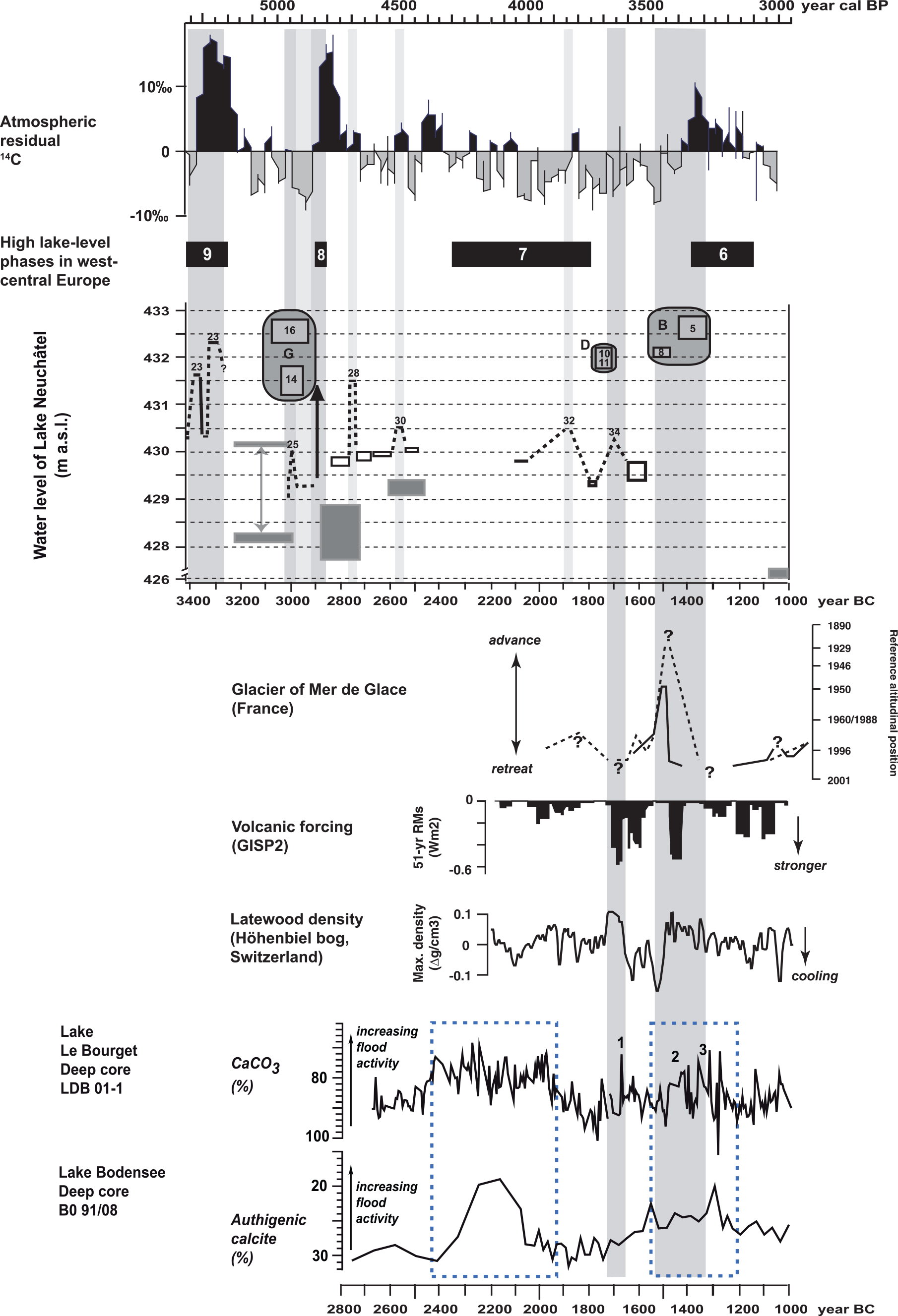
Comparison of the lake-level data from Lake Neuchâtel with other palaeoclimatological and palaeoenvironmental data, that is, variations in the atmospheric residual 14C (Reimer et al., 2009), lake-level fluctuations in West-Central Europe (Magny, 2013), variations in length of the glacier of Mer de Glace in the French Alps (Le Roy et al., 2015), variations in volcanic activity from GISP2 record (Kobashi et al., 2013), variations in subalpine latewood density from Höhenbiel bog in Switzerland (Renner, 1982) and variations in flood activity as reconstructed from deep cores in Lake Le Bourget in the French Pre-Alps (Arnaud et al., 2005) and in Lake Bodensee in southwestern Germany (Wessels, 1998). Lake-level data from Lake Neuchâtel – grey rectangles and grey double arrow (lower panel): altitude range of the tree-ring-dated occupation layers of the Neolithic and Bronze Age lake-dwelling sites in the bay of Auvernier (Arnold and Langenegger, 2012; Boisaubert, 1982; Schifferdecker, 1982); dotted black line: lake-level data from Concise (the numbers from 23 to 34 indicate the phases defined by Magny, 2008); in grey: lake-level data from Colombier/Les Plantées de Rive with phases G, D and B (this study); vertical black arrow: lake-level rise defined by Brochier (1986) from sediment sequences in Auvernier bay and dated to ca. 2880 BC.
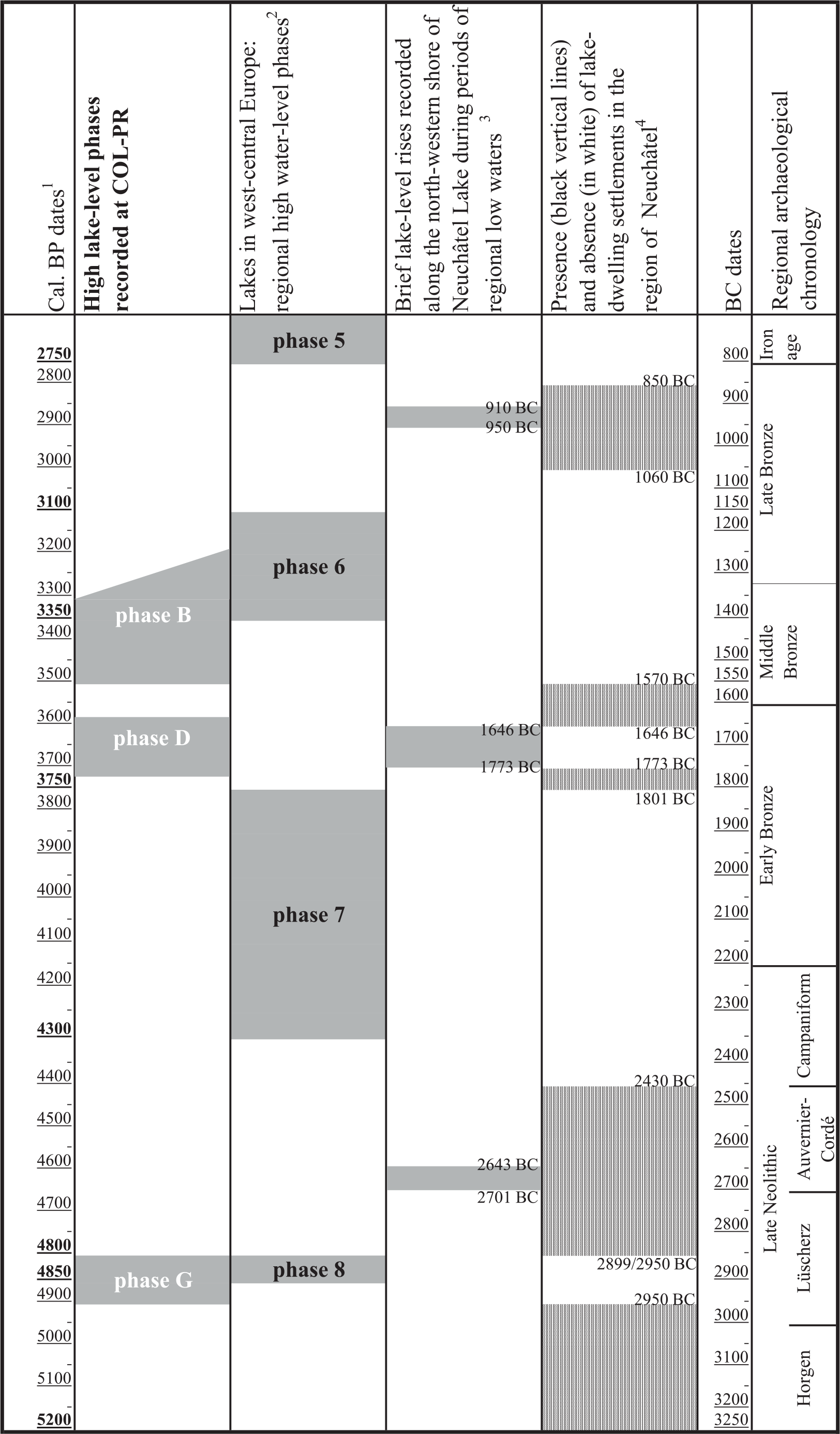
Schematic representation of the timing of high water levels recorded at COL-PR compared with the major lake water fluctuations recognised in West-Central Europe.
The deposits of the earliest sedimentary phase G (L.17 to L.14) documented by the COL-PR sediment sequence witness a deposition in a lakeshore environment and a subsequent pedogenesis in a terrestrial context. L.16 (beach deposit corresponding to a mean water level – see section ‘Methods’ – and radiocarbon dated to ca. 3270–2920 BC; Figure 3) suggests a maximal mean lake water level at ca. 432.3–432.8 m a.s.l. The raised lake beach or a gravelly ridge-bar materialised by L.14, formed up to ca. 1.3 m above mean water levels (section ‘Methods’ and Table 3), indicates a mean water level of ca. 431.2–431.8 m a.s.l. Thus, L.14 was deposited during a phase of falling lake water. According to the available data, the deposition of most of the sediments of phase G occurred during the time interval of ca. 3300–2900 BC, while the soil formation processes recognised for L.14 took place around ca. 2910–2670 BC (Figure 3).
The comparison of the data collected at the COL-PR site with data provided by the study of lake settlements in the surrounding areas allows us to better define the timing of this period of high water level. The chronology of the combustion event (ST.7) which occurred during the accumulation of the beach deposits of L.16 is rather large (Tables 1 and 2), but the calibration of the radiocarbon dates shows a higher probability for the time span of 3100–2920 BC (Tables 1 and 2, ETH-54039). In addition, archaeological and dendrochronological datasets from sites along the northwestern shore of Lake Neuchâtel show an occupation hiatus of the lakeshore during some 100 years between ca. 2950 and 2850 BC (Arnold, 2009; Figures 5 and 6). This suggests that the highest lake level recorded by L.16 (sedimentary phase G) may have coincided roughly with this occupation hiatus. This hypothesis is supported by (1) the altitudes of organic archaeological settlement layers of lake-dwelling sites studied in the region (Figure 5); (2) the poor preservation (erosion) of the Horgen-dated settlements which existed before this high water-level event (Arnold, 2009; Campen and Kurella, 1998; Schifferdecker, 1982; Winiger, 2008); (3) a lake-level increase (phase 25 dated to 3013–2962 BC), erosion processes and an occupation hiatus tree-ring dated to 2962–2899 BC at the site of Concise/Sous-Colachoz, situated on the northwest shore of Lake Neuchâtel (Figure 5, phase 25; Magny, 2008; Winiger, 2008); and (4) a lake-level rise dated to 2880 BC for the sites studied in the bay of Auvernier (Figure 5; Brochier, 1986).
High lake levels during this period have also been concluded by previous major sedimentological or archaeoenvironemental studies (Brochier and Moulin, 2010, Auv-ph.VII; Magny, 2008, ph.25; Schifferdecker, 1982). Interestingly, the data from the COL-PR site allow a more robust assessment of the lake-level rise around 2900 BC (Figure 5). Thanks to the topographic position of the site, the lakeshore deposits unravelled at COL-PR enable to deduce the maximal and landward extension of this lake water rise.
The sedimentary phase F (L.13) shows a combination of flooding and possibly colluvial processes which are reworking the underlying layer. The flooding episodes are most probably related to the dynamics of the neighbouring river as indicated by (1) the sedimentary characteristics (Table 3) and (2) the altitudes of the lake-dwelling sites recognised in the surroundings (Figure 5) which, for the time span of ca. 2600–2400 BC (Figures 3 and 5), are situated around 429.00–429.40 m a.s.l., while L.13 is at ca. 433.00 m a.s.l. The marked importance of flooding processes is indicated by the relatively high proportion of the coarse fraction and the abundance of aquatic molluscs in this layer (Table 3 and Figure 4a). The stratigraphic data and the radiocarbon date available (Figure 3 and Tables 1 and 2, ETH-54056) suggest that the timing of deposition and the in situ evolution of L.13 is ca. 2620–2470 BC. It is possible, however, that the deposition of L.13 (or at least part of it) occurred during the transition between the Lüscherz and Auvernier settlement phase around 2700 BC (Tables 1 and 2 and Figure 5). During this period at the Auvernier/La Saunerie site (Figure 1), sandy lake deposits burry the Lüscherz-dated archaeological layer (Boisaubert, 1982; Tables 1 and 2), and tree-ring data suggest a short (ca. 60–70 years) hiatus between the successive archaeological layers (Arnold, 2009). All these suggest that this period of more intensive lakeshore flooding could correspond to the deposition of L.13. A significant lake-level rise is also documented at Concise/Sous-Colachoz during the settlement phase dendro-dated to 2826–2663 BC (Magny, 2008; Figure 5, phase 28). Regional dendrochronological investigations highlight a marked break in forest exploitation around 2700 BC, materialised by a major regional forest opening before this date and significant wood regeneration after it. This was also accompanied by an apparent interruption in the lake-dwelling occupation and a significant temporary decline in the demography (Magny and Schifferdecker, 1980; Wolf and Hurni, 2002). The pronounced flooding dynamics testified by L.13 of the COL-PR site support the hypothesis of climatic deterioration evoked as one of the possible reasons for this regional lake settlement trend by the above-cited studies.
The deposits of the sedimentary phase E (L.12) are the result of gradual colluvial and flooding processes. The dated charcoals (Tables 1 and 2) indicate radiocarbon dates of 1876–1693 BC (ETH-60920) for the lower part and 1750–1610 BC (ETH-54058) for the upper part, thus the timeframe of the second part of the Early Bronze Age. The available lake-level data for this period indicate fluctuations between ca. 429.5 and 430.5 m a.s.l. (Figure 5; Magny, 2008). The depositional altitudes of this layer are ca. 433.20–433.40 m a.s.l. (Table 3), that is, up to 4 m higher than the lake levels reconstructed up till now for the considered period. Consequently, the available data allow us to interpret the calcareous components of these deposits as indicators of regular flooding of the alluvial plain by the river.
The following sedimentary phase D (L.11 and L.10) suggests a short lake-level rise reaching the topographic position of the site. These sediments reflect a mean lake water level of ca. 432.2 m a.s.l., while their stratigraphic position indicates that this lake-level highstand occurred during the second part of the Early Bronze Age, that is, between 1750–1610 and 1640–1500 BC (Figure 3 and Tables 1 and 2). This high lake-level event has also been detected and tree-ring dated to 1773–1646 BC at Concise/Sous-Colachoz (Magny, 2008; Figure 5, ph.34)a. However, it is interesting to highlight that as in the case of the sedimentary phase G, the COL-PR site, thanks to its topographic position, allows a better estimation of the magnitude and extent of this hydrological event.
The deposits of the sedimentary phase C (L.9), similarly to those of phase E, are the result of flooding and colluvial erosion/sedimentation processes. In addition, the soil characteristics suggest pedogenetic processes, that is, a stabilisation period at the surface of L.9. Two charcoals collected at the upper part of this soil give a time range of ca. 1642–1500 BC (ETH-54060 and 60921, Tables 1 and 2). The Middle Bronze Age tumulus (ST.1) was constructed on this surface. All these indicate that this layer was deposited between the final part of the Early Bronze Age and the beginning of the Middle Bronze Age, that is, before ca. 1600 BC (Tables 1 and 2). During this period, data from lake-dwelling sites in the neighbourhood indicate lake-level values of ca. 429.4–429.8 m a.s.l. (Magny, 2008; Figure 5). In consequence, the altitudes of the layer documented at the COL-PR site (433.20–433.50 m a.s.l.) suggest once more that the calcareous part of this deposit stems from alluvial flooding.
The sedimentary phase B (L.8–L.4) records the major high water-level phase occurring during the Middle Bronze Age. This period is characterised by an overall absence of lake-dwelling settlements in the northern Circum-Alpine region (Menotti, 2015), whereas along the shores of Lake Neuchâtel an occupation hiatus of about 510 years, between 1570 and 1060 BC (Figure 6), is identified (Arnold, 2009; Winiger, 2008). Consequently, for the first time at Lake Neuchâtel, the sedimentary sequence of the COL-PR site allows to evaluate the magnitude and depositional dynamics of this major Middle Bronze Age lake-level rise. The sedimentological characteristics of the layers documented at COL-PR indicate that this high lake-level phase occurred in several episodes. During a first short rise indicated by L.8, the mean lake level reached ca. 432.00–432.20 m a.s.l. This was followed by an episode of somewhat lower water levels (L.7). The subsequent sub-phase of this high lake water–level period lasted somewhat longer and at its paroxysm water levels reached altitudes of ca. 432.4–432.6 m a.s.l. as suggested by L.5. By the end of this phase, while the lake level was falling, fine-textured flood deposits still reached the site (L.4). Thanks to the archaeological structures and the stratigraphic record of COL-PR (Figure 3), it is possible to conclude that phase B of lake-level highstand occurred after ca. 1642–1500 BC (ETH-54060 and 60921, Tables 1 and 2) and before ca. 1370–1110 BC (ETH-54049 and 54050, Tables 1 and 2), with a first rise event (L.8) developing after 1640–1500 BC and before 1410–1230 BC (Figure 3) and a second maximal rise materialised by L.5 after ca. 1410–1230/1500–1320 BC (ETH-54046/54052, Tables 1 and 2 and Figure 3) and before 1370–1110 BC (ETH-54049, Tables 1 and 2 and Figure 3).
The sedimentary phase A (L.3, L.2, L.1) occurring after this major lake-level rise is characterised by a succession of mostly fine-textured sediments of colluvial and alluvial origin. The soil characteristics recorded in its upper part (L.1) indirectly indicate a fall in lake level, postdating the Middle Bronze Age highstands. This is in agreement with the archaeological data indicating a Late Bronze Age lakeshore at ca. 426–427 m a.s.l. (Arnold and Langenegger, 2012). It is worthwhile to highlight that this lake-level fall of up to 5 m occurred in less than 350 years.
Comparison with other palaeohydrological and palaeoclimatic records
The main point of interest of the COL-PR sedimentary sequence is that it provides new and robust evidences of higher lake-level phases in West-Central Europe dated at ca. 4850, 3650 and 3450–3250 cal. BP, that is, ca. 2900, 1700 and 1500–1300 BC (Figure 6). Figure 5 shows a comparison of the COL-PR lake-level record with other regional and extra-regional palaeohydrological and palaeoclimatic archives, more particularly for the time interval 3450–3100 cal. BP which is of special interest for the history of the Bronze Age lake-dwellings. Taken together, the successive lake-level highstands highlighted by the COL-PR record are in agreement with the regional pattern of Holocene lake-level variations established for West-Central Europe: the sedimentary phases G (L.16 to L.14) and B (L. 8 and 5) correspond to regional phases 8 and 6 of higher lake-level conditions at 4850–4800 and 3350–3100 cal. BP, respectively (Magny, 2013). The absence of phase 7 of the regional high lake-level in the COL-PR record suggests that this phase has been locally a minor one in comparison with phases 8 and 6. The COL-PR record also appears to be in agreement with the palaeohydrological records established from deep cores from Lakes Bourget (Arnaud et al., 2005) and Bodensee (Wessels, 1998). In addition, taking into account the age uncertainties inherent to the radiocarbon dating, the apparent tripartition of the period of increasing flood activity at ca. 3600–3200 cal. BP (events labelled 1, 2 and 3 in Figure 5, lower panel) may find equivalents in the highstand events recorded by L.10–11, L.8 and L.5 of the COL-PR sediment sequence, respectively. Finally, the particular interest of the COL-PR record is to confirm (1) the importance of regional phase 8 dated to 4850–4800 cal. BP (Figure 6), despite its short duration, as well as (2) the fact that the Middle Bronze Age was punctuated by a major bipartite lake-level highstand and (3) was preceded by a marked forerunner event at ca. 3650 cal. BP, that is, ca. 1700 BC, well-observed and tree-ring dated at the Early Bronze Age lake-dwelling of Concise/Sous-Colachoz (Magny, 2008; Winiger, 2008).
As shown by Figure 5, a good matching also appears between the COL-PR record and glacier advances and retreats of the Mer de Glace reconstructed and tree-ring dated by Le Roy et al. (2015). A major advance of the French glacier centred to ca. 3450 cal. BP and preceded by a minor advance at ca. 3600 cal. BP finds equivalents in lake-level rise events recorded by L.5–8 and L.10–11 in the COL-PR sequence. They also coincide with two successive negative anomalies (i.e. climate cooling) in wood density in the central Swiss Alps (Renner, 1982), as well as with a marked minimum of timberline in the Austrian Alps (Nicolussi et al., 2005). Altogether, this supports the climatic significance of the COL-PR record. In addition, multiple records using various proxies have shown the worldwide importance of a climatic oscillation centred on ca. 3600–3400 cal. BP, that is, 1650–1450 BC (Magny et al., 2009).
Regarding the forcing factors, Figure 5 shows that the lake-level events reconstructed from the COL-PR sediment sequence coincide with major positive anomalies in the atmospheric residual 14C (Reimer et al., 2004) at 4850–4800 and 3350–3100 cal. BP. This suggests an influence of solar forcing in agreement with regional and worldwide lines of evidence for these phases (Magny, 2004b, 2013; Mayewski et al., 2004). Other synchronicities between the COL-PR lake-level rises and episodes of increasing volcanic activity (Kobashi et al., 2013) argue for a possible combination of both solar and volcanic forcings, more particularly for the lake-level highstand dated to ca. 3650 cal. BP (second part of the Early Bronze Age): it coincides with a relatively minor peak in the atmospheric residual 14C, but a marked increase in the frequency of volcanic events (Kobashi et al., 2013). Another peak in volcanic activity around 3400 cal. BP appears to coincide with the lake-level rise marked by phase B in the COL-PR sediment sequence. Multiple mass movements, dated between 1872 BC and 1608 BC and possibly followed by tsunamis, have also been documented for the northern shores of Lake Geneva (Kremer et al., 2014); they might have been favoured by the climatic deterioration recorded in phase D of the COL-PR sequence.
Implications for the Neolithic and Bronze Age societies north of the Alps
Previous quantitative reconstructions of the variations in climatic parameters reflected by lake-level variations in West-Central Europe have shown that phases of higher lake-level conditions correspond to climate reversals marked by cooler and wetter climate conditions, and more particularly to a decrease in the summer temperature and a shortening of the growing season (Magny, 2006; Magny et al., 2001, 2009). Thus, the phases of lake-level highstands and their associated humid climatic conditions may have not only influenced the location of the villages of Neolithic and Bronze Age societies north of the Alps but also affected the subsistence strategies of these first agropastoral communities.
The important but short-lived lake-level rise dated to ca. 4850 cal. BP (phase G) occurring during the first part of the Lüscherz period has been recognised as a break in the lake settlements around Lake Neuchâtel (Arnold, 2009; Winiger, 2008). The amplitude of the lake-level rise of ca. 3 m could well explain this. The magnitude of the lake-level rise reconstructed for the last major lake-level highstand, recognised at ca. 3500–3200 cal. BP (phase B), from the COL-PR sediment sequence provides new key reference data contributing to the explanation of the general abandonment of lake-dwellings north of the Alps during the Middle Bronze Age. In addition, the COL-PR sediment sequence shows that this Middle Bronze age event was preceded by a marked but short-lasted rise event at ca. 3650 cal. BP (phase D) during the last part of the Early Bronze Age. This forerunner event provoked a break of the Early Bronze Age lake-dwellings at Concise-Colachoz (Winiger, 2008).
Finally, the archaeological and palaeoenvironmental investigations carried out at the COL-PR site attest a remarkable persistence of the sacred vocation of the site despite flood events and recurrent, significant lake-level rises which affected it during the Late Neolithic as well as the Early and Middle Bronze Age periods. It is also noteworthy that this ceremonial site was located at the limit of the lake-influenced area, that is, at the interface between the drier slopes more suitable for agropastoral activities and the lakeshore villages situated nearby downslope. The interbedding of flood deposits and rests of successive monuments suggests a significant role played by the collective memory in the perpetuation for hundreds of years of the ceremonial and funeral vocation of the site. This is particularly remarkable for the Middle Bronze Age despite the increasingly evident signs of the major climatic deterioration to come.
Conclusion
Recent archaeological investigations at COL-PR on the northwestern shore of Lake Neuchâtel (Switzerland) highlighted an exceptional concentration of anthropic structures dated from the Late Neolithic to the Late Bronze Age and interbedded within an alternation of terrestrial and lacustrine deposits. Using a sedimentological approach based on various proxies and with the support of radiocarbon dates from terrestrial material and additional chronological information provided by archaeological structures and artefacts, the study of the COL-PR sediment sequence allows to reconstruct past changes in lake level of Lake Neuchâtel for the period 4900–3100 cal. BP and leads to the following conclusions.
Three major lake-level highstands occurred at ca 4900, 3650 and 3400 cal. BP which appear to be in agreement with the regional pattern of lake-level fluctuations. They also show synchronicities with increases in flood activity documented by deep cores from Lake Le Bourget in the French Pre-Alps and Lake Bodensee in southwestern Germany, changes in length of the glacier of Mer de Glace in the French Alps or variations in latewood density from Swiss subalpine zone. More particularly, the COL-PR sediment sequence provides new robust data to document phases of climatic deteriorations responsible for the general abandonment of lake-dwellings north of the Alps during the Middle Bronze age in response to a possible combination of solar and volcanic forcing.
Finally, it is worth to note the interbedding of rests of successive monuments within terrestrial and lacustrine deposits. This indicates a relative continuity of the spatial organisation of the area at the interface between lacustrine and terrestrial domains, despite interruptions provoked by major lake-level rises and associated flooding in response to periods of climatic deterioration. All these suggest a significant role played over hundred years by the collective memory in the perpetuation of the ceremonial and funeral vocation of the site.
Footnotes
Acknowledgements
The authors would like to thank to Marc Juillard, Marielle Zanetta and Philippe Zuppinger for their help in editing Figures 1–4. They are also grateful to Jeannette Kraese for her assistance in checking and improving the English of the manuscript. Two anonymous reviewers are also acknowledged for their constructive comments and suggestions.
Funding
The author(s) received no financial support for the research, authorship and/or publication of this article.