
Abstract
High-resolution pollen and charcoal records from Chenghai Lake, northwestern Yunnan Province of China, are presented in this study. These records reveal changes in climate and human activity since 8220 cal. yr BP, and the drivers of climatic change are further discussed based on spectral analysis of Tsuga and evergreen oak pollen percentages. The pollen record indicated that the climate in the low altitude area was relatively warm and moderately dry, whereas the climate in the high altitude area was relatively cool and humid during the period 8220–4670 cal. yr BP, corresponding to the Holocene climate optimum, although the seasonality of precipitation increased between 5180 and 4670 cal. yr BP. From 4670 to 3470 cal. yr BP, the temperature declined, and the precipitation and its seasonality decreased. Between 3470 and 1860 cal. yr BP, the temperature was still relatively low, and precipitation appeared to decrease further. At the same time, human activity represented by agricultural planting began to influence this study area, but the intensity of human activity was relatively weak. After 1860 cal. yr BP, the climate was gradually becoming drier and the intensity of human activity such as deforestation and slash-and-burn agriculture increased. Spectral analysis of Tsuga and evergreen oak pollen percentages shows statistically significant periodicities of ~1500 and ~200 years at the ≥95% confidence level, which suggests that insolation and feedback interactions on millennial to centennial scales are the primary forcing mechanisms of the southwest monsoon and past climatic change during the Holocene in northwestern Yunnan Province, southwestern China.
Introduction
Yunnan Province in southwestern China, especially western Yunnan Province, is a region strongly affected by the southwest summer monsoon (Indian summer monsoon). Because of its close proximity to the Tibetan Plateau, there is a sharp altitudinal gradient across this province, ranging from above 5000 m a.s.l. in the northwest to ~1000 m a.s.l. in the south. The steep altitudinal gradient imparts a marked climatic gradient across the province and consequently a range of geomorphological settings, which has contributed to high plant diversity across the region (Lin et al., 1986; Walker, 1986; Wu et al., 1987). Thus, Yunnan Province has been commonly considered as the ‘Plant Kingdom’ of China (Wu et al., 1987). Archaeological records from Yunnan Province show that Neolithic culture characterized by the appearance of agriculture based on rice and cereal production, pottery, and grinding stone (Li, 2004) began to emerge at around 4000 cal. yr BP or a little earlier (Han, 1981; Li, 2004). Most Neolithic cultural relics appeared between 3000 and 4000 cal. yr BP (Li, 2004). Historical records show that the first local government (Ancient Dian Kingdom) was established by Qiao Zhuang at 279 BC in Yunnan. Yunnan began to be formally governed by the central government during the Ch’in dynasty (221–206 BC) (Zhou, 2011). Because of these favorable geographical conditions and a long cultural history, Yunnan Province has become a key region to reconstruct vegetation history, paleoclimate changes, human activity, and past dynamics of the southwest monsoon.
During the past three decades, there has been an increasing focus on Holocene climate changes and human activity in Yunnan Province (Chen et al., 2014; Hillman et al., 2016; Hodell et al., 1999; Li et al., 2015; Lin et al., 1986; Long et al., 1991; Shen et al., 2006; Song et al., 2012; Sun et al., 1986; Wang et al., 2016; Wu et al., 1991, 1998; Xiao et al., 2014, 2015; Zhang et al., 2002, 2004, 2015). However, some early studies do not discuss detailed climate fluctuation during the Holocene or do not consider the influence of human activity because of low temporal sampling resolution and age uncertainties. Some recent high-resolution studies reveal different results related to the timing and duration of the Holocene climatic optimum, the timing and frequency of abrupt climate changes, and the time and intensity changes in human activity. The reasons may be regional differences of climate in Yunnan Province, different interpretation of proxy data, and local variation in human impacts. In order to better understand the long-term history and drivers of change in Yunnan Province, it is necessary to develop chronologically precise, high-resolution studies that can help clarify regional differences of climate and human activity in Yunnan Province and detect possible drivers of change.
Here, we analyzed a ~6-m-long lake sediment core spanning 8220 cal. yr BP from Chenghai Lake in northwestern Yunnan Province, China. High-resolution pollen and charcoal records from the core reveal new evidence for regional climate variability, human activity, and dynamic mechanisms of vegetation and climate changes since 8220 cal. yr BP in southwestern China.
Regional setting
Chenghai Lake (26°27′–26°38′ N, 100°38′–100°41′ E) is a structural fault lake located on the southeast edge of the Qinghai–Tibet Plateau, at the transition zone from Hengduan Mountains to Yunnan–Guizhou Plateau, approximately 18 km southeast of Yongsheng county in northwestern Yunnan Province, southwestern China (Figure 1). This lake was formed during the early Pleistocene and linked with Jinsha River via Haikou River before the 1690s (Editorial Board of Yongsheng County Annals, 1989). Since the 1690s, because of the gradual decline in the water level in Chenghai Lake and the construction of a dam on the Haikou River, Chenghai Lake became a closed and slightly brackish lake in 1779 (Editorial Board of Yongsheng County Annals, 1989). The elevation of the lake is 1503 m a.s.l. with a maximum depth of 35.1 m (average 25.7 m), surface area of 77.2 km2, and volume of 19.87 × 10⁸ m3. The lake basin is surrounded on three sides by mountains, and the south is relatively low and flat (Figure 1). The altitude of the highest mountain around the lake is 3963.5 m, which is located to the northeast of the lake. This lake is hydrologically recharged by precipitation, surface runoff, and groundwater at present (Editorial Board of Yongsheng County Annals, 1989).
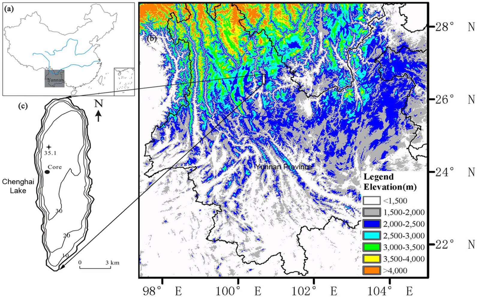
(a) Map showing the study area in China. (b) Topographic map of Yunnan Province and the location of Chenghai Lake. (c) The shape and isobath of Chenghai Lake.
The lake region is characterized by a warm-temperate mountain monsoon climate, which is one of typical hot-dry river valley areas along Jinsha River. It is mainly affected by the warm-humid airflow from the Indian Ocean and Bengal Bay in summer and by the southern branch of the westerly airflow in winter and is also affected by the local climate of the Qinghai–Tibet Plateau. Thus, the lake region has distinct rainy and dry seasons with wet in summer and dry in winter. Meteorological data during the period 1981–2014 at the Yongsheng meteorological station (26.68°N, 100.75°E, 2130.5 m a.s.l.) near Chenghai Lake (Figure 2) show that the mean annual temperature is 13.9°C, with average monthly temperatures in July and January of 18.4°C and 8.0°C, respectively. The average annual precipitation is 668 mm, with an average of 16.4 mm in January and 113.1 mm in July, and most of the precipitation (72.8%) is concentrated in the June–October period.

Climate diagram from Yongsheng meteorological station (26.68°N, 100.75°E; elevation of 2130.5 m a.s.l.) near Chenghai Lake showing monthly temperature and precipitation. These data are 34-year climate averages for the period 1981–2014.
Altitudinally controlled vegetation belts in the region are notable (Editorial Board of Yongsheng County Annals, 1989; Wu et al., 1987). In the low and hot river valley area between 1100 and 1500 m a.s.l., the vegetation type is dry-hot river valley grassland with scattered trees or shrubs because of high temperature and low precipitation. The trees are mainly Toona ciliata, Ficus microcarpa, Gossampinus malabarica, and Melia azedarach, and the shrubs are mainly dwarf drought-tolerant plants such as Phyllanthus emblica, Salix matsudana, Dodonaea Miller, and Opuntia stricta. From 1500 to 2500 m a.s.l., Pinus yunnanensis forest and mixed forest of Pinus and oaks are present. Trachycarpus fortunei, Alnus nepalensis, Eucalyptus robusta, Salix spp., Populus, Ligustrum lucidum, Helwingia japonica, and Coriaria sinica grow dispersedly in these forests. Juglans regia is planted as an economic plantation forest in the area. Between 2500 and 3500 m a.s.l., the vegetation type is cold or cool mountain conifer forest dominated by Pinus yunnanensis, accompanied by other conifer plants such as Picea, Tsuga, and Pinus densata. Above 3500 m a.s.l., this vegetation type gives way to alpine shrubland, composed primarily of dwarf oaks, Pinus yunnanensis, and Cuculus poliocephalus. At present, the cereal crops in the basin of this region between 1600 and 2500 m a.s.l. are dominated by Oryza sativa (rice), Vicia faba, and Triticum (wheat). Gossypium spp. and Saccharum officinarum are commonly cultivated in the basin below 1600 m a.s.l. In the farmland of the mountainous region above 2500 m a.s.l., Solanum tuberosum, Fagopyrum esculentum, and Avena sativa are the main cereal crops (Editorial Board of Yongsheng County Annals, 1989; Wu et al., 1987).
In recent decades, the extent of forest coverage has been seriously reduced. Forest coverage in Yongsheng county was 42% in 1950s, declining to 24% in 1985 (Editorial Board of Yongsheng County Annals, 1989). The standing forest stock decreased by 31.1% from 1975 to 1985 in Chenghai town, and forest coverage in the catchment of Chenghai Lake was reported to be only 12.7% in 2003 (Du, 2006). Today, forest around the lake (below 2500 m a.s.l.) has been almost completely cleared, with only a small amount of secondary forest present.
Materials and methods
Coring and sampling
In March 2012, a 6.01-m-long core (CH-1) was recovered from the center of Chenghai Lake in a water depth of 31.8 m (26°33′29.4″N, 100°39′6.7″E) using a 6-cm inner diameter UWITEC Coring Platform System (Niederreiter Richard Uwitec) (Figure 1). The core lithology was homogeneous lacustrine sediment consisting of reddish, fine-grained silty clay. Total organic carbon (TOC) contents range between 0.8% and 2.9% by weight. The core was sectioned at 1 cm intervals. Samples were stored at 4°C until analyzed. In addition, a shorter core through the sediment–water interface for 210Pb and 137Cs measurements was taken nearby using a gravity corer. The short core was extruded vertically in the field and collected in 1 cm increments. Because the top of the CH-1 core may be disturbed, the uppermost 60 cm of the core was replaced by the short core by core correlation between the CH-1 core and the short core using magnetic susceptibility. At the same time, magnetic susceptibility was used for core correlation to exclude overlapping sediment parts between two core segments and ensure the recovery of a continuous sediment sequence. Grain size through the entire core changes little; hence, magnetic susceptibility variations may be mainly caused by content of magnetic minerals. Pollen and charcoal were analyzed at 2–3 cm intervals.
Dating methods
The core chronology was established using 210Pb and 137Cs analysis in the short core and accelerator mass spectrometry (AMS) radiocarbon dating in the CH-1 core. The upper 38 cm sediments were analyzed for 210Pb, 226Ra, and 137Cs by direct gamma spectrometry using the Ortec HPGe GWL series of well-type, coaxial, low-background, intrinsic germanium detectors (Appleby, 2001) at Nanjing Institute of Geography and Limnology, Chinese Academy of Sciences. Owing to the non-monotonic variation in unsupported 210Pb activity, the dates were calculated using the constant rate of supply (CRS) model (Appleby, 2001). However, calculations using the simple CRS model revealed a discrepancy between the 210Pb dates and the 137Cs peak of AD 1963. To solve this problem, a composite model was used to obtain a chronology for recent sediments of Chenghai Lake (Appleby, 2001). Namely, the sediment core was divided into the upper and lower sections by the depth of 137Cs peak. According to the concentration of 210Pbex, different formulae were used to the two sections for the chronology calculation. The depth–age data using the 210Pb-CRS model corrected by the 137Cs 1963 peak are shown in Figure 3a. The CRS model gave 38 dates between AD 1844 (38 cm) and AD 2012.

(a) Activities of 137Cs and 210Pbex in Chenghai Lake core CH-1: the 1963 peak is indicated, and 210Pb ages vs depth derived from a composite CRS model. (b) The reservoir effect for the bulk sediment dates with the plant macrofossil dates. (c) Bayesian age model (Blaauw and Christen, 2011). Gray scales indicate all likely age–depth models, and dotted lines indicate the 95% confidence ranges.
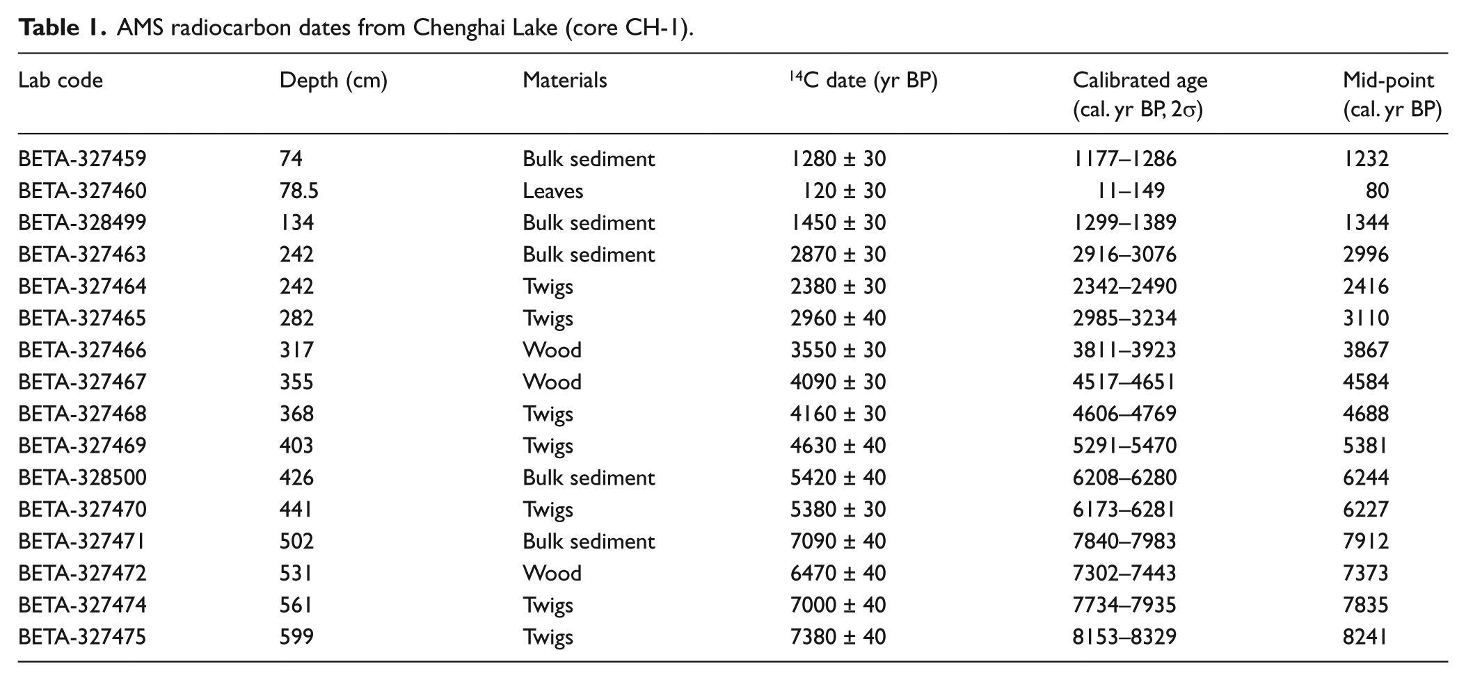
Sixteen radiocarbon dates were determined at the Beta Analytic Radiocarbon Laboratory on 11 samples of terrestrial plant macrofossil, including leaves, twigs, and wood, and 5 samples of bulk sediment. All dates were calibrated to calendar years before present (0 BP = AD 1950) with the program CALIB 7.0 utilizing the IntCal13 calibration data set (Reimer et al., 2013; Table 1).
AMS radiocarbon dates from Chenghai Lake (core CH-1).
Laboratory analysis
Pollen samples were processed using heavy liquid separation (Moore and Webb, 1978; Nakagawa et al., 1998). In brief, the preparation procedures involve treatment with 10% HCl to remove carbonates, 10% KOH to remove humic substances, heavy liquid floatation (a ZnCl2 solution was used having a specific gravity of between 2.0 and 2.2), and acetolysis to remove cellulose, followed by mounting the sample in glycerin jelly. Pollen samples were examined using a Zeiss microscope at magnifications of 400× and 630×. An average of 543 terrestrial grains per sample was counted. Terrestrial pollen percentages were based on a sum of pollen excluding aquatic herbs, ferns, and algae, while percentages of aquatic herbs, ferns, and algae were calculated using the total pollen sum. Here, Poaceae grains with diameters greater than 40 µm were counted separately, as a measure of cereal abundance (Lamb et al., 2003). The data are expressed both as percentage and pollen accumulation rate and graphed using Tilia·Graph (Grimm, 1993).
Preparation of samples for charcoal analysis is identical to the heavy liquid separation used for pollen preparation. Only one step to pass through a 125-µm sieve is added after samples were treated with 10% KOH. Charcoal particles >125 µm were counted under a stereomicroscope at magnifications of 40×, while abundance of charcoal <125 µm was estimated by the point count method (Clark, 1982; Li et al., 2009). The charcoal data are expressed as charcoal accumulation rate (CHAR).
Numerical methods
Stratigraphic zones were mainly determined on the pollen data with CONISS in the Tilia program (Grimm, 1987). In order to simplify and identify trends in the multi-dimensional pollen data, we subjected the data set to a detrended correspondence analysis (DCA). A total of 38 terrestrial pollen types with percentage values greater than 1% in at least two samples were included in the DCA. The ordination was performed using inter-species correlations and square-root transformation of pollen percentage data in the program Canoco version 4.5 (Ter Braak and Šmilauer, 2002).
Results
Chronology
The 14C dating results show an offset of 350–1210 years (averaging 700 years) between the bulk sediment dates and the plant macrofossil dates (Figure 3b), which we consider to be the result of older carbon being incorporated into the bulk sediment samples. Thus, the age model was performed by Bacon 2.2 using the default settings for lake sediments with 5-cm resolution (Blaauw and Christen, 2011) constrained by the 11 AMS 14C dates on the plant macrofossil and a 210Pb profile of recent sediments from the short core (Figure 3c). According to the age model, the bottom date is presumed to be 8220 cal. yr BP. The average temporal sampling resolution is ~40 years for the fossil pollen and charcoal records.
Pollen and charcoal records
A total of 244 pollen and spore types were identified from 194 pollen samples. The pollen record is dominated by tree pollen, averaging 78.5% (Figure 4). Pollen percentages of shrubs and herbs are relatively low, averaging 4.4% and 17.1%, respectively. The dominant tree taxa are Pinus, Alnus, and evergreen oaks. Tsuga, Betula, Juglans, deciduous oaks, and Lithocarpus/Castanopsis also have relatively high percentages. Shrub pollen is dominated by Dodonaea. The main components of herb pollen are Poaceae, Artemisia, Lamiaceae, and Gesneriaceae. Aquatic herbs (including wetland herbs) are mainly Cyperaceae and Myriophyllum, whose pollen percentages are relatively low (not presented in the pollen diagram). Ferns are mainly represented by Polypodiaceae and Microlepria. In the record, there are many tropical species, including Sterculia, Ficus, Elaeocarpus, Ternstroemia, Randia, Engelhardtia, Myrtaceae, Symplocos, Camellia, Eurya, Dodonaea, Myrsine, Mallotus/Macaranga, Maesa, Premna, Calamus, and Clethra (Li et al., 2000), and their pollen percentages are combined into a tropical arboreal type. The pollen record was divided into seven zones based on CONISS of the pollen data and visual inspection (Figure 4). The characteristics of pollen and charcoal in these zones are described from bottom to top as follows.

Pollen percentage of selected taxa and charcoal accumulation rate diagram from Chenghai Lake (core CH-1), northwestern Yunnan Province, China.
Zone CH-1 (601–394 cm, 8220–5180 cal. yr BP)
In the zone, Pinus pollen percentages are very high (mean of 53.4%, ranging from 37.1% to 75.4%). Tsuga (3.8%) and Lithocarpus/Castanopsis (2.0%) pollen percentages are also relatively high compared with the other pollen zones. Pollen percentages of Alnus (2.3%) and evergreen oaks (12.4%) are relatively low. Many tropical plants are present, and tropical arboreal pollen percentages are relatively high (2.7%). Pollen percentages of herbs (12.0%) and total pollen accumulation rates (TPARs; 2047 grains cm−2 yr−1) are low. Accumulation rates of charcoal particles >125 µm are high as a whole (9.8 grains cm−2 yr−1), whereas accumulation rates of charcoal particles <125 µm are relatively high compared with the average for the entire core with obvious fluctuation, averaging 0.05 cm2 cm−2 yr−1.
Zone CH-2 (394–365 cm, 5180–4670 cal. yr BP)
The zone is characterized by the obvious decrease in Pinus pollen percentages and the highest evergreen oak pollen percentages and accumulation rates of charcoal particles <125 µm, averaging 37.8%, 26.9%, and 0.09 cm2 cm−2 yr−1, respectively. Tsuga (3.7%), Lithocarpus/Castanopsis (2.1%), and tropical arboreal (2.9%) pollen percentages are still relatively high. Herb pollen percentages increase slightly (13.3%). TPARs (3511 grains cm−2 yr−1) increase markedly, and accumulation rates of charcoal particles >125 µm (10.9 grains cm−2 yr−1) show no obvious changes.
Zone CH-3 (365–302 cm, 4670–3470 cal. yr BP)
Average Pinus pollen percentages are the highest for the entire core (54.1%). Pollen percentages of evergreen oaks, Tsuga, Lithocarpus/Castanopsis, and tropical arboreal taxa decrease, averaging 18.9%, 3.0%, 0.9%, and 0.7%, respectively. Betula (1.2%) and deciduous oaks (3.4%) are also relatively lower than those in the other zones. Herb pollen percentages (9.9%) are the lowest through the profile. TPARs (2465 grains cm−2 yr−1) are still relatively high. Accumulation rates of charcoal particles >125 µm (12.0 grains cm−2 yr−1) increase, whereas accumulation rates of charcoal particles <125 µm (0.02 cm2 cm−2 yr−1) decline significantly.
Zone CH-4 (302–197 cm, 3470–1860 cal. yr BP)
In the zone, pollen percentages of Pinus (40.8%) decrease gradually. Pollen percentages of evergreen and deciduous oaks are high, averaging 21.2% and 5.5%, respectively. Pollen percentages of Tsuga, Lithocarpus/Castanopsis, and tropical trees and shrubs are very low, averaging 2.3%, 0.9%, and 1.5%, respectively. Herb pollen percentages (15.9%) increase obviously and are represented by the first obvious increase in Poaceae (5.6%) and the slight increases in Artemisia (2.4%) and Gesneriaceae (3.9%). Fern spore percentages (2.5%) decline gradually. TPARs (4344 grains cm−2 yr−1) increase. Accumulation rates of charcoal particles >125 µm (8.4 grains cm−2 yr−1) decrease evidently, and accumulation rates of charcoal particles <125 µm are still very low (0.03 cm2 cm−2 yr−1).
Zone CH-5 (197–134 cm, 1860–990 cal. yr BP)
Pinus pollen percentages markedly decrease to the lowest level for the entire core, averaging 22.3%. Pollen percentages of Alnus and Poaceae increase to relatively high values compared with the previous pollen zones, averaging 13.5% and 9.1%, respectively. Evergreen oaks (24.3%) increase slightly. Juglans pollen percentages (0.8%) first increase from a very low level. Pollen percentages of Tsuga (1.3%) and Lithocarpus/Castanopsis (0.7%) decrease further. Artemisia pollen percentages (4.0%) increase slightly. Fern spore percentages (2.0%) are very low. TPARs (4711 grains cm−2 yr−1) are the highest through the profile. Accumulation rates of charcoal particles >125 µm continue to decline, whereas accumulation rates of charcoal particles <125 µm increase markedly, averaging 4.4 grains cm−2 yr−1 and 0.06 cm2 cm−2 yr−1, respectively.
Zone CH-6 (134–68 cm, 990–210 cal. yr BP)
Average Pinus pollen percentages (33.2%, 6.9–56.7%) increase with large fluctuations. Pollen percentages of deciduous oaks (4.1%, 1.6–7.8%) and evergreen oaks (15.3%, 10.0–26.8%) decrease gradually. Tsuga pollen percentages (1.9%) are still relatively low. Pollen percentages of Alnus (8.9%) decrease significantly with several high values in the middle of the zone, corresponding to the low values of Pinus pollen percentages. Juglans pollen percentages (1.6%) are highest for the entire core. Dodonaea pollen percentages (1.4%, 0–4.4%) first increase obviously from the bottom to the top of the zone. Herb pollen percentages (27.4%) increase further, which is mainly represented by the obvious increase in Poaceae (13.2%) and the slight increase in Artemisia (4.6%). Rumex appears with low percentages (1.4%). Fern spore percentages (4.7%) increase. TPARs (1372 grains cm−2 yr−1) and accumulation rates of charcoal particles <125 µm (0.01 cm2 cm−2 yr−1) decrease rapidly. Accumulation rates of charcoal particles >125 µm (3.4 grains cm−2 yr−1) decline slightly.
Zone CH-7 (68–0 cm, after 210 cal. yr BP)
The zone is characterized by the highest pollen percentages of Alnus, Poaceae, Artemisia, and Rumex and the lowest pollen percentages of Tsuga, deciduous oaks, and evergreen oaks for the entire core, averaging 19.1%, 13.6%, 10.8%, 3.8%, 0.6%, 2.3%, and 7.2%, respectively. Pinus pollen percentages (24.1%) are relatively low. Juglans pollen percentages (0.7%) decrease slightly. TPARs (3567 grains cm−2 yr−1) and accumulation rates of charcoal particles <125 µm (0.05 cm2 cm−3) increase markedly, and accumulation rates of charcoal particles >125 µm (3.2 grains cm−2 yr−1) are the lowest through the profile. The pollen assemblage characteristics change abruptly from AD ~1970. Namely, pollen percentages of Alnus (26.6%, ranging from 22.9% to 30.6%) and Dodonaea (9.0%, 3.4–17.1%) are markedly higher than during all the other periods.
Ordination of pollen assemblages
The DCA results of 37 terrestrial pollen types from 194 samples reveal that the first two axes capture 34.4% of the variance in the pollen data (axis 1: 28.7%, axis 2: 5.7%) (Figure 5a and b). The ordination separates the species reflecting human disturbance (e.g. Poaceae, Juglans, Rumex, Alnus, and Dodonaea) on the left side from those indicating natural changes (e.g. Abies, Tsuga, Fraxinus, Premna, Maesa, Hypericum, Lithocarpus/Castanopsis, Ulmus, evergreen oaks, and deciduous oaks) on the right side of axis 1 (Figure 5a). Indicator pollen of human disturbance can be classified into the following: (1) pollen of cultivated plants such as Poaceae, (2) pollen of economic plants such as Juglans, (3) anthropogenic weed pollen such as Rumex, and (4) pollen of secondary plants such as Alnus and Dodonaea (Wu et al., 1987; Xiao et al., 2012). Thus, the first axis may reflect the intensity of human activity. Namely, the intensity of human activity was the weakest on the right side of axis 1, whereas it was the strongest on the left side of axis 1. On the right side of axis 1, Premna, Maesa, Hypericum, and Castanopsis/Lithocarpus indicating warm and moderately humid conditions lie at the top of axis 2, while Abies, Tsuga, and Fraxinus denoting relatively cool and humid conditions locate at the bottom of axis 2, which seems to mean that axis 2 can be expressed as climatic change from warm and moderately humid conditions to relatively cool and humid conditions. However, because axis 2 only accounts for 5.7% of variance, its environmental significance is uncertain and needs to be examined by other independent proxies.
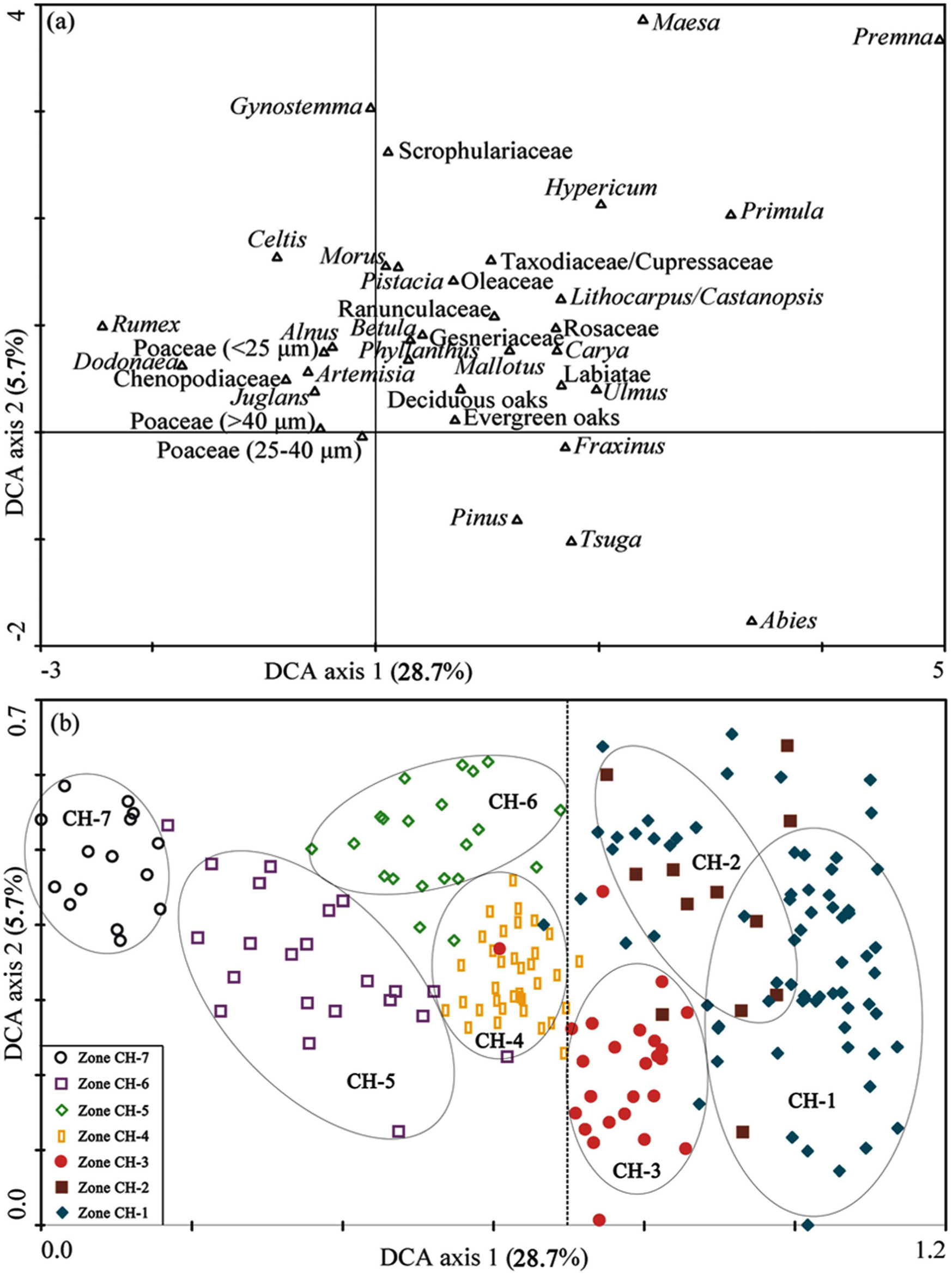
DCA ordination with the pollen percentage data: (a) DCA biplot on pollen species and (b) DCA biplot on pollen samples.
The DCA separates approximately the samples into seven groups, although zones CH-1 and CH-2 cannot be completely separated (Figure 5b). Samples of zones CH-1, CH-2, and CH-3 show high positive scores on the first axis, while samples of zones CH-4, CH-5, CH-6, and CH-7 have moderate to low scores on axis 1. These may mean that the vegetation changes before 3470 cal. yr BP around the study area were mainly controlled by the climatic changes, and the vegetation changes after 3470 cal. yr BP were increasingly controlled by human activities with the climatic signal weakening gradually.
Discussion
Vegetation, climate, and human activity histories inferred from the pollen and charcoal records of Chenghai Lake
Modern pollen rain from 42 lakes in Yunnan and southwestern Sichuan Province shows that the downslope transportation ability of Tsuga pollen is relatively weak, and its pollen percentages are less than 1.0% in the pollen assemblages from surface lake sediments below 3200 m a.s.l. and not higher than 1.7% in the pollen assemblages from moss polsters below 3050 m a.s.l. (Xiao et al., 2011). Thus, relatively high Tsuga pollen percentages (>2.0%) in the sediment core of Chenghai Lake indicate that the cool mountain coniferous vegetation belt including Tsuga is nearer to this lake and/or the proportion of Tsuga plants is higher at that time (when Tsuga pollen percentages are more than 2.0%) than at present. Tsuga forest is today restricted to an altitudinal range of 2800–3200 m a.s.l. (a cloud line) in southwestern China (Shen et al., 2006), where the climate is characterized by perennial rainy and foggy conditions (Xiao et al., 2014). Tsuga requires an annual precipitation of about 1000–1500 mm, but tolerates cold temperatures (Jarvis, 1993). Thus, the proportion of Tsuga pollen has been considered as a good proxy for humidity or even precipitation (Jarvis, 1993; Shen et al., 2006). Relatively high evergreen oak percentages occur at surface lake sediments with low to moderate mean annual temperature (−3 to 8°C) and precipitation (650–920 mm) (Xiao et al., 2011). Evergreen oaks are drought-tolerant sclerophyllous taxa, which can withstand the drought stress conditions of the winter and spring in southwestern China but require a moderate winter climate. Thus, it is also used as an indicator of seasonality of precipitation (Jarvis, 1993). Relatively high tropical arboreal pollen percentages indicate warm temperature conditions.
Charcoal particles >125 µm were interpreted as indicators of local fires (Patrickson et al., 2010; Whitlock and Millspaugh, 1996). Microscopic fragments (<125 µm charcoal) can be transported over long distances by wind or water, so <125 µm charcoal is more likely to reflect the regional fire occurrence (Carcaillet et al., 2001; Whitlock and Millspaugh, 1996).
The pollen and charcoal records from Chenghai Lake reveal seven significant vegetation and fire changes since 8220 cal. yr BP, which is a response to changing climatic conditions and human activity around the study area.
During the period 8220–5180 cal. yr BP, the pollen record indicates that the low altitude area around the lake was mainly covered by Pinus forest and mixed forest of Pinus and oaks with a relatively high proportion of tropical trees and shrubs such as Mallotus/Macaranga, Maesa, and Premna. Tsuga trees reflecting cool and humid conditions were common in the high altitude area around the lake. The vegetation types around the lake suggest that the climate in the low altitude area was relatively warm and moderately dry, whereas the climate in the high altitude area was relatively cool and humid. CHARs indicate that local fires often occurred in the low altitude area around the lake, and strong regional fires also occurred at times. The possible reason is that the relatively high temperature during the period accelerated fuel desiccation, resulting in frequent fire activity.
Between 5180 and 4670 cal. yr BP, the proportion of evergreen oaks in the forest increased markedly and the area of Pinus forest decreased. The proportion of tropical trees and shrubs in the low altitude area, the proportion of Tsuga trees in the cool mountain coniferous vegetation belt, and/or the location of this belt were similar to the former period. These vegetation changes suggest that the temperature had not changed, but the seasonality of precipitation increased with more humid conditions in summer and drier conditions in winter and spring. The relatively high temperature and the mild and drier conditions in winter and spring may have been a significant driver of frequent and intensive fire events, resulting in the relatively high accumulation rates of charcoal particles >125 µm and the highest accumulation rates of charcoal particles <125 µm during this period.
From 4670 to 3470 cal. yr BP, the area of Pinus forest increased and the proportion of evergreen oaks in the forest decreased. The proportion of tropical trees in the low altitude area and the proportion of Tsuga trees in the cool mountain coniferous vegetation belt declined significantly. At the same time, the proportion of herbs in the forest was the lowest since 8220 cal. yr BP. These vegetation changes suggest that the temperature declined and the precipitation and its seasonality decreased. The significant decline in accumulation rates of charcoal particles <125 µm reflects a decrease in regional fire events, which may relate to the mitigation of drought in winter and spring in the region because drought in winter and spring is the main natural condition for forest fires in Yunnan Province. The increase in accumulation rates of charcoal particles >125 µm implies that local fire events continued to occur frequently, which may be caused by the still warm and moderately dry climate conditions in the local low altitude area around the lake.
During the period 3470–1860 cal. yr BP, the area of Pinus forest decreased gradually, the proportion of evergreen oaks in the forest did not change, and the proportion of herbs in the forests increased. The cool mountain coniferous vegetation belt including Tsuga was still located in the high altitude area, and/or the proportion of Tsuga trees in this belt was relatively low. Ferns usually grow under humid conditions (Sun et al., 2003; Van der Kaars et al., 2000), so the decrease in fern percentages suggests a drier climate. All these reflect that the temperature was still relatively low and precipitation might have further decreased. The first increase in Poaceae pollen percentages may indicate that human activity such as crop cultivation began to influence this study area, but the intensity of human activity was likely still relatively weak.
From 1860 to 990 cal. yr BP (namely, AD 90–960), the area of Pinus forest declined markedly, the proportion of evergreen oaks was still relatively high, the proportion of herbs in the forests increased further, and the proportion of secondary Alnus plants increased evidently. The cool mountain coniferous vegetation belt including Tsuga retreated to the higher altitude area and/or the proportion of Tsuga trees in this belt decreased. These vegetation changes reflect that the climate dried further. At the same time, the first increase in Juglans pollen percentages indicates that people began to cultivate economic plants around the study area. The further increase in Poaceae pollen percentages may imply the enhancement of human cultivation activity. The marked decrease in Pinus forest may be influenced by human’s selective deforestation because it is a high-quality construction timber. The relatively high accumulation rates of charcoal particles <125 µm reflect that regional fire events were frequent and intensive, which may be influenced by a shift to a drier climate combined with stronger human activity (such as slash-and-burn activity). The relatively low accumulation rates of charcoal particles >125 µm suggest that local fire activity weakened, which may be because the area around this lake was already transformed to managed agricultural land.
Between 990 and 210 cal. yr BP (namely, AD 960–1740), the proportion of deciduous and evergreen oaks in the forests decreased and secondary Pinus and Alnus alternated as the dominant components in the forests. The areas of shrub-grass vegetation with more secondary and relatively drought-tolerant shrub Dodonaea increased, which suggests that the climate was gradually becoming drier and forest disturbance related to human impacts may be increasing. The gradually drying climate during the period corresponded to a continuous decline in the water level of Chenghai Lake after Ming Dynasty (AD 1368–1644) and even no outflow from Chenghai Lake after the end of Qianlong period (AD 1736–1795) of Qing Dynasty (Editorial Board of Yongsheng County Annals, 1989). TPARs decrease rapidly to very low values from ~990 cal. yr BP, indicating that biomass (especially forest coverage) declined fast to very low levels. The rapid decline in forest coverage is most likely the result of human-caused deforestation. The very low levels in accumulation rates of charcoal particles >125 and <125 µm imply that fires rarely occurred, which may be caused by insufficient fuel for fires because of the rapid decline in biomass. These vegetation changes and the highest Juglans pollen percentages, the obvious increase in Poaceae pollen percentage (including Poaceae >40 µm), and the first relatively high Rumex pollen percentages reflect a greater intensity of human activity in the region. Although ferns usually grow under humid conditions, high levels of disturbance will also promote a cover of ferns (Van der Kaars et al., 2000). Thus, the increase in fern spore percentages during this period is likely a response to intensive human disturbance.
After 210 cal. yr BP (namely, AD 1740), the marked increase in TPARs and accumulation rates of charcoal particles <125 µm is most likely related to the rapid sediment deposition rates in the uppermost part of the core with no or little core compression, rather than high biomass and intensive regional fires. The pollen assemblage indicates that the area of Pinus forest decreased, and the areas of shrub-grass vegetation were the largest and the proportion of evergreen oaks in the forest was the lowest since ~8220 cal. yr BP. Alnus was a significant component in the forest. These vegetation changes indicate more serious deforestation and more intensive agricultural activities during this period than the previous periods. During the past ~40 years, the abrupt change in the pollen assemblage shows that the primary forest was almost completely cleared, and the forest was dominated by secondary Pinus and Alnus with relatively low proportion of evergreen oaks. The vegetation in the low altitude area was mainly shrub-grass vegetation dominated by secondary Dodonaea.
Comparison with regional climate records and intensity of human activity
The paleoclimatic reconstructions based on the pollen and charcoal records from Chenghai Lake suggest that the climate during the period 8220–4670 cal. yr BP may correspond to Holocene climate optimum, although the seasonality of precipitation increased between 5180 and 4670 cal. yr BP. The timing and duration of the Holocene climate optimum are still a focus of controversy in Holocene climate studies. Because the basal age of core CH-1 reaches only 8220 cal. yr BP, this study cannot contribute to the debate over an early versus mid-Holocene climate optimum.
Our study reveals that the temperature declined, and precipitation and its seasonality decreased from 4670 cal. yr BP, without an obvious signal of human activity in the pollen and charcoal records. This is similar to the opinion of Zhao et al. (2009) that an abrupt decrease in effective moisture inferred from pollen data in the monsoonal region of China at ca. 4500 cal. yr BP may be attributed to climate change. This is commensurate with the view that ~4500 cal. yr BP is a time of rapid climate change in monsoonal regions (Hong et al., 2003; Wang et al., 2005, 2008).
Between 3470 and 1860 cal. yr BP, the temperature was still relatively low and precipitation might have decreased further. At the same time, the first increase in Poaceae pollen percentages in the pollen assemblage from 3470 cal. yr BP indicates that human activity represented by agricultural planting began to influence this study area, but the intensity of human activity was relatively weak. Archaeological records from Yunnan Province show that the earliest Neolithic cultural relics of Yunnan were found at around 4000 cal. yr BP or a little earlier (Han, 1981; Li, 2004). 14C age of Baiyang village cultural relic, a representative Neolithic cultural relic in Binchuan county which is an adjacent county to Chenghai Lake, is 3770 ± 85 14C yr BP (Li, 2004). These support the viewpoint that vegetation changes from 3470 cal. yr BP around this study area may be caused by superimposed influence of human activities and climatic cooling and drying.
After 1860 cal. yr BP, on one hand, the pollen assemblage suggests that climate was gradually becoming drier, and on the other hand, it indicates that the intensity of human activity such as selective deforestation and agricultural cultivation was gradually increasing. Namely, slash-and-burn agriculture activity was increasing and economic plants such as Juglans were planted around the study area during the period 1860–990 cal. yr BP (AD 90–960), which corresponds to historical documents that Yongsheng county had entered the era centered in agricultural production activities after the Han Dynasty (206 BC–AD 220) (Editorial Board of Yongsheng County Annals, 1989). Between 990 and 210 cal. yr BP (AD 960–1740), the forest was rapidly cleared and agricultural cultivation enhanced further, which is mostly prompted by the settlement of military garrisons associated with since Yuan Dynasty (AD 1279–1368) in Yongsheng county (Editorial Board of Yongsheng County Annals, 1989). The vegetation changes after 210 cal. yr BP (AD 1740) indicate more substantial deforestation and more intensive agricultural activities than the previous periods. During the past ~40 years, primary forest was almost completely cleared by human activity.
In southwestern China, the pollen records from Xingyun Lake (1772 m a.s.l.; Chen et al., 2014), Qinghai Lake (1885 m a.s.l.; Xiao et al., 2015), Erhai Lake (1974 m a.s.l.; Shen et al., 2006), and Haligu (3277 m a.s.l.; Song et al., 2012) all reveal vegetation changes related to human activity. Significant decreases in evergreen oaks, Liquidambar, Peterocarya, Ulmus, and Corylus/Carpinus pollen percentages and marked increases in secondary Alnus and Poaceae pollen percentages at 5500 cal. yr BP in Xingyun Lake may reflect human-driven forest disturbance (Chen et al., 2014). A similar interpretation may apply to the Qinghai Lake record, reflected in the abrupt decline in Lithocarpus/Castanopsis and evergreen oak pollen percentages and rapid increase in Alnus and Poaceae pollen percentages at 4280 cal. yr BP (Xiao et al., 2015). A decline in evergreen broadleaved tree pollen (Cyclobalanopsis/Lithocarpus, Castanopsis) and the observed increase in Poaceae pollen percentages and the number and frequency of disturbance taxa (Plantago, Lamiaceae, Artemisia, Chenopodiaceae) at ~6000 cal. yr BP in Erhai Lake suggest the initial evidence of human activity (Shen et al., 2006). A reduction in Quercus pollen observed at 2400 cal. yr BP in Haligu Lake may be indicative of increasing human coppicing (Song et al., 2012). The pollen records from Lugu Lake (2685 m a.s.l.; Wang, 2012) and Tiancai Lake (3898 m a.s.l.; Xiao et al., 2014) reveal that late-Holocene vegetation changes occurred at 3400 and 2900 cal. yr BP, respectively. However, human impact indicators are not recognized in the two records until 1240 and 260 cal. yr BP, respectively. The lack of synchronous change in late-Holocene vegetation dynamics in this region further confirms that human influence may have played a significant role in altering vegetation during this period.
Definitive evidence for anthropogenic modification of the landscape in the form of increases in crop and disturbance pollen percentages along with rapid decreases in arboreal pollen were detected at ~1000 cal. yr BP in Xingyun and Qinghai lakes (Chen et al., 2014; Xiao et al., 2015) and at ca. 2140 cal. yr BP in Erhai Lake (Shen et al., 2006). Comparable signals in pollen accumulation rates and pollen percentages of crop and disturbance taxa were discerned at 990 cal. yr BP in Chenghai Lake. All these reflect that rapid deforestation in Yunnan Province occurred at different times after ~2000 cal. yr BP in different places. This period coincides with a period of increased human settlement in Yunnan Province, including the introduction of terracing and irrigation (Shen et al., 2006; Sun et al., 1986).
In general, our study reveals that human activity becomes an increasingly important factor in vegetation changes since 3470 cal. yr BP. Although Zhao et al. (2009) argue that insolation-induced change in monsoon intensity and precipitation was responsible for vegetation changes during the late Holocene, they also consider that human disturbance also played a major role and contributed to the abrupt vegetation shift over the past several millennia, especially over the past 2000 years. However, it is still difficult to distinguish the relative influence of climatic change and human activity on vegetation, particularly before ~2000 cal. yr BP, and how the anthropogenic signal is distinguished from the climatic signal needs still to be explored.
Possible dynamic climate mechanisms
Spectral analysis can help in delineating the factors forcing the monsoon and climatic change through time. In this study, Tsuga serves not only as a good proxy for humidity (Jarvis, 1993; Shen et al., 2006; Xiao et al., 2014) but also as an indicator for the strength of the southwest monsoon. Evergreen oaks are used as an indicator of dry winter and spring climate (Jarvis, 1993) and may also indicate the strength of the southern branch of the westerly wind system. Although human influence on the pollen record is relatively strong since 1860 cal. yr BP, the human influence is mostly manifested by the early and intensive influence on Poaceae and Pinus. The significant influence of human activities on evergreen oaks began only at ~990 cal. yr BP, and the influence of human activities on Tsuga is insignificant during the late Holocene because of its high-altitude distribution area. Thus, the time series records of Tsuga pollen percentages for the past ~8220 cal. yr BP (194 data points) and evergreen oak pollen percentages between ~8220 and ~990 cal. yr BP (158 data points) were selected to carry out spectral analysis using REDFIT 3.8 program (Schulz and Mudelsee, 2002; Figure 6), under the assumption that these taxa are not significantly affected by human activities.
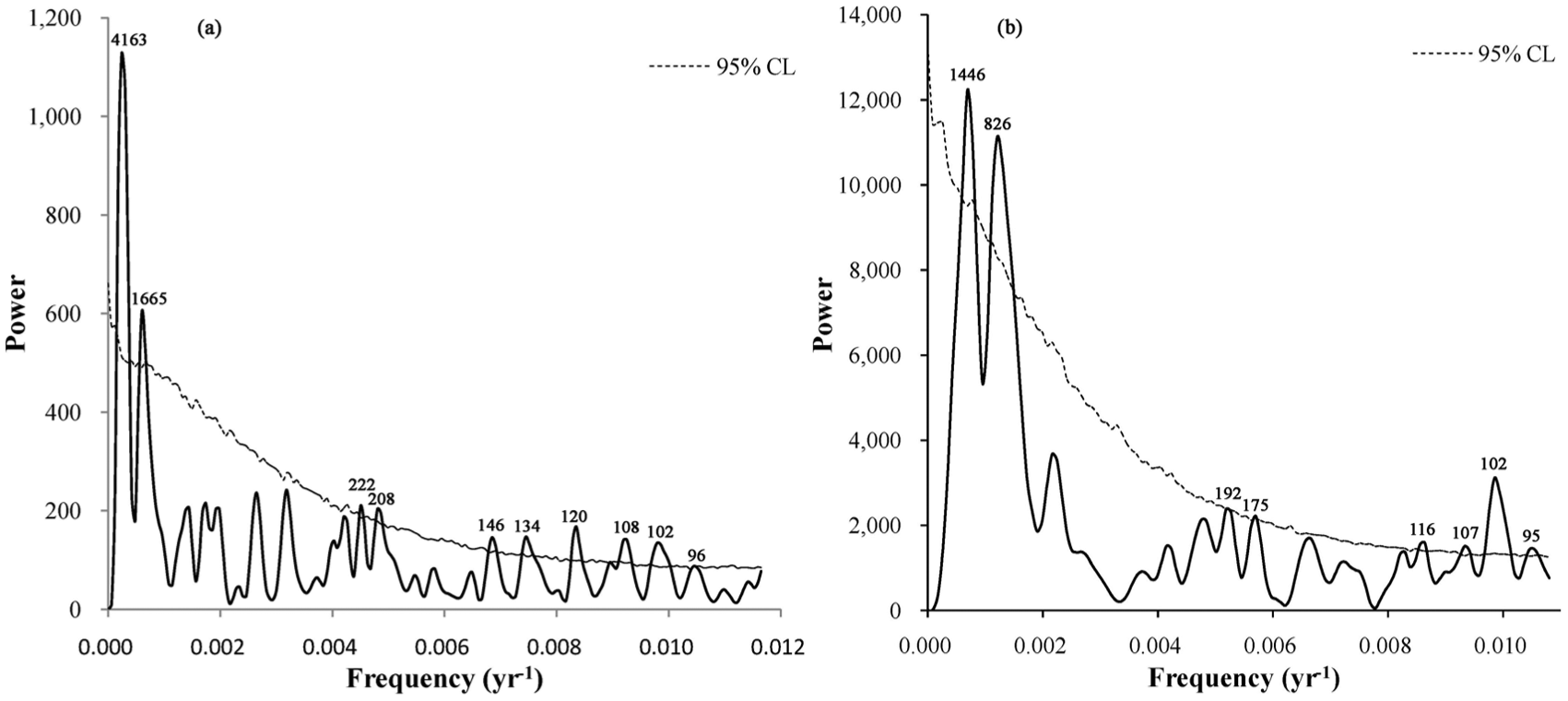
Spectral analysis of (a) Tsuga and (b) evergreen oak pollen percentage time series. The 95% confidence level is shown by dash line. The spectral analysis was done using REDFIT (Schulz and Mudelsee, 2002).
Spectral analyses of Tsuga pollen percentages exhibit dominant periodicities of 4163, 1665, 222, 208, 146, 134, 120, 108, 102, and 96 years, and evergreen oak pollen percentages show significant cycles of 1446, 826, 192, 175, 116, 107, 102, and 95 years at the ≥95% confidence level.
Reliability of the apparent 4163-year periodicity in the time series of Tsuga pollen percentages is uncertain because the sediment core does not span two full cycles of 4163-year periodicity. However, it is worth noting that this lies close to the ~4400- to 4600-year cycle that has been recognized around the world in many published studies (Barker et al., 2007; Bond et al., 1997; Grützner et al., 2002; Keigwin and Jones, 1994; Leuschner and Sirocko, 2003; Mayewski et al., 1997; Yiou et al., 1991, 1995). As discussed by Pestiaux et al. (1988) and Yiou et al. (1991), these quasi-periods may reflect combination tones of precessional and obliquity frequencies.
The 1665-year cyclicity in the time series of Tsuga pollen percentages and the 1446-year periodicity in the time series of evergreen oak pollen percentages are similar to the well-known ‘1500 years’ periodicity first observed in the North Atlantic ice rafted debris (IRD) records, which reveal a cycle of 1340 ± 500 years, believed to be influenced by the variations in the solar energy output (Bond et al., 2001). Although the existence of such cycles in the North Atlantic climatic regime has been disputed, similar cyclicity has been reported not only in the high latitudes (Bianchi and McCave, 1999; Bond et al., 1997; Darby et al., 2012; Mayewski et al., 1997; Wunsch, 2000; Yasuhara et al., 2014) but also in low-latitude Indian monsoon domains (Gupta et al., 2005; Leuschner and Sirocko, 2003; Thamban et al., 2007). The forcing of these cycles, as well as their existence, remains controversial. Clemens (2005) considers that the ~1500-year cycle may derive from heterodynes of centennial-band solar cycles as observed in the Holocene record of atmospheric 14C production, which suggests a link between centennial-scale solar variability and abrupt climate change at the millennial time scale. Bianchi and McCave (1999) consider that solar variation is an unlikely forcing mechanism and an oceanic internal oscillation in ‘conveyor’ strength is more probable for the ~1500-year cycle because no clear ~1500-year periodicity in either 14C or 10Be has been reported from ice cores so far. Several recent publications (Darby et al., 2012; Debret et al., 2009; Obrochta et al., 2012; Sorrel et al., 2012) also supported this viewpoint. The ~1500-year cycle reflected in the pollen record from Chenghai Lake is most likely to be indicative of teleconnections between the southwest monsoon and the North Atlantic climate. It may be mainly because of the transfer, amplification, and/or modulation of climatic variations in the global thermohaline and atmospheric circulation mode driven by internal oceanic forcing in the North Atlantic circulation. However, we cannot completely rule out an indirect response to solar forcing.
The 826-year cycle in the time series of evergreen oak pollen percentages is close to the ~750-year cycle, reported widely within the low-latitude monsoon systems (Sarkar et al., 2000; Staubwasser et al., 2003; Wang et al., 1999). This periodicity has been suggested that it is related to the global oceanic thermohaline circulation by controlling the incorporation of 14C into the ocean (Neff et al., 2001). The presence of this cycle in the tree ring Δ14C data as well as Asian monsoon records may thus support the extreme sensitivity of low-latitude monsoons to subtle variations in solar radiation levels (Thamban et al., 2007).
In addition, the spectra analysis of Tsuga pollen percentages reveals 222-, 208-, 146-, 134-, 120-, 108-, 102-, and 96-year cycles, and the spectra analysis of evergreen oak pollen percentages reveals 192-, 175-, 116-, 107-, 102-, and 95-year cycles. Considering that the 2σ error of the calibrated ages averages ~80 years, the shorter periodicities less than 200 years are no longer discussed here. The ~200-year Suess solar cycle (Usoskin and Mursula, 2003) is widely ascribed to be of solar origin (Agnihotri et al., 2002; Castagnoli et al., 1990; Fleitmann et al., 2003; Gupta et al., 2005; Neff et al., 2001; Stuiver and Braziunas, 1989, 1993). At the same time, the periodicity has been reported in the other paleoclimate records from the Indian monsoon domain (Agnihotri et al., 2002; Berger and Von Rad, 2002; Fleitmann et al., 2003; Neff et al., 2001; Staubwasser et al., 2002; Tiwari et al., 2005). This indicates a century-scale relation between insolation and the southwest monsoon variability, and even between insolation and westerly wind strength, which reinforces the hypothesis that the intensity of Asian monsoon is affected by the variations in solar activity (Kerr, 2005; Tiwari et al., 2005; Wang et al., 2005).
Conclusion
We present a high-resolution reconstruction of vegetation and fire history, climate change, and human activity from an 8220-year lake sediment record from Northwestern Yunnan Province, southwestern China. The variation in pollen percentages and accumulate rates of pollen and charcoal reveals that the climate in the low altitude area was relatively warm and moderately dry, whereas the climate in the high altitude area was relatively cool and humid during the period 8220–5180 cal. yr BP. Between 5180 and 4670 cal. yr BP, the temperature had no obvious change, but the seasonality of precipitation increased with more humid conditions in summer and drier conditions in winter. The temperature declined, and the precipitation and its seasonality decreased from 4670 cal. yr BP, without a clear signal of human activity. Between 3470 and 1860 cal. yr BP, the temperature was still relatively low and precipitation appears to decrease further. At the same time, human impact represented by agricultural activity began to influence the study area. Since 3470 cal. yr BP, human activity becomes an increasingly important factor in vegetation changes. After 1860 cal. yr BP, the climate was gradually becoming drier and the intensity of human activity such as deforestation and cultivation increased gradually. At ~990 cal. yr BP, biomass (especially forest coverage) declined rapidly to very low levels. During the past ~40 years, the primary forest was almost completely cleared by people.
Spectral analyses of Tsuga and evergreen oak pollen percentages from Chenghai Lake exhibit dominant reliable periodicities of ~1500, ~750, and ~200 years. These periodicities are most likely associated with the global thermohaline and atmospheric circulation feedbacks coupled with potential solar forcing that is influencing the southwest monsoon and past climatic change on millennial scale. Solar forcing is likely to be a significant factor on centennial or shorter timescales during the Holocene in northwestern Yunnan Province, southwestern China.
Footnotes
Acknowledgements
The authors thank Ming Ji and Qingfeng Jiang for doing fieldwork and Weilan Xia for the 210Pb and 137Cs date measurements. The paper has been strongly improved, thanks to the comments of two anonymous reviewers.
Funding
This research was financially supported by the Program of Global Change and Mitigation (2016YFA0600501), the National Natural Science Foundation of China (41572149, 41272188, 41372184), and Nanjing Institute of Geography and Limnology, CAS (NIGLAS2011KXJ02).