
Abstract
The present-day Palar River and its palaeochannel located in the Southern Peninsular India were investigated with a multidisciplinary approach. The main aim of the study was to reconstruct the palaeoenvironment history of the Palar River basin and to delineate the role of Holocene fluctuations that played a major role in the geomorphological evolution of the region since the Holocene period. The results obtained based on sedimentary facies analysis supported by elemental concentrations and optically stimulated luminescence (OSL) dates reveal distinct seven climatic phases since the past ~10 ka. Phase 1 signifies a very high precipitation as attested by the low CWI with high Rb/Sr ratio. Subsequent to Phase 1, a decreasing trend in the northeast monsoon rainfall (NEMR) is observed (Phase 2). Phase 3 (~4.83–3.59 ka) reflects a decrease in NEMR further supported by low Mn/Al, Mg/Al and Chemical Index of Alteration (CIA) values. Phase 4 (~3.59 ka) is marked by high sand flux, higher K/Al, Ti/Al, Rb/Sr and Ba/Sr ratios coupled with lower values of CaO/MgO, Mn/Al and Fe/Al indicating wetter conditions in the catchment area resulting in the intense weathering of the bedrocks caused owing to the increase in NEMR precipitation. Phase 5 (3.26–2.42 ka) reveals a decline in NEMR precipitation coupled with rapid upstream avulsion because of neotectonic activity that occurred in an intense dry phase. Phase 6 (~1.88–1.44 ka) is marked by an augment NEMR causing higher K/Al, Mg/Al, Ti/Al ratios, CIA and CWI values. Finally, Phase 7 (~1.44 ka–present) is marked by lowered elemental solubility and mobility reflecting short periods of weaker or deteriorated NEMR. The documented record of the Palar River and palaeochannels suggests Holocene NEMR variability in the study region and is synchronous with the various proxy records of NEMR-dominated regions, however, revealing an inverse coupling with southwest monsoon rainfall (SWMR) during the Holocene period.
Keywords
Introduction
The Indian monsoon system is a very important component of the global climate, and its intensity and amount have fluctuated over time (Babeesh et al., 2017a; Duplessy et al., 2005; Fleitmann et al., 2003; Galy and Lanord, 2001; Galy et al., 2008; Kudrass et al., 2001; Kumaran et al., 2005; Lupker et al., 2013; Mayewski et al., 2004; Raj et al., 2015; Singh et al., 2008, 2016). Reconstruction of this phenomenon is significant as the data generated would be useful for predicting the future climate trends. More importantly, the southern Indian peninsular region under study is a rain-fed agriculture region, and the major paddy growing belt is very much dependent on monsoon availability.
Indian subcontinent experiences two major monsoon seasons. The summer monsoon brings rains from the southwest direction (southwest monsoon (SWM)) and is responsible for a major portion of the annual rainfall in India. However, rainfall received during the northeast monsoon is also important, especially in the southern part of India and Sri Lanka (Figure 1). In Southern Peninsular India, especially the Palar River basin receives dominantly the northeast monsoon rainfall (NEMR), spatially covering a small area as compared to the region receiving southwest monsoon rainfall (SWMR). The northeast monsoon is also termed as the ‘retreating monsoon’ (northeast) season in which the zone of maximum rainfall migrates to southern India, Sri Lanka and the neighbouring sea (Rajeevan et al., 2012).

Large-scale topographical maps with dominant seasonal hemispherical airflows.
During the past two decades, monsoon fluctuations have been reconstructed using different continental and marine records, and these fluctuations since the late Quaternary to Holocene in Asia are documented by various workers (Achyuthan et al., 2014; Bond et al., 2001; Fletcher et al., 2013; Kale, 2003; Mayewski et al., 2004; Prasad and Enzel, 2006; Prasad et al., 2007; Singh et al., 1964; Staubwasser and Weiss, 2006). The intensity of the monsoon and tectonics at different spatial and temporal scales controls the rate of weathering and erosion in the catchment areas of major rivers (Burbank et al., 2003; Clift et al., 2010; Singh et al., 2016). This affects the river processes such as river discharge, sediment flux and channel avulsion/migration that, in turn, shape the landscape of the region (Bookhagen et al., 2005; Kale, 2007; Singh et al., 2016), and these parameters have controlled the evolution of landforms in the southern peninsular India (Resmi et al., 2016). Moreover, in the past few decades, several studies suggest the existence of a network of palaeochannels that resulted because of the migration of the rivers in the east coast of Southern Peninsular India with special reference to the Palar River (Ramasamy et al., 2011; Resmi et al., 2016; Subramanya, 1996). Resmi et al. (2016) based on remote sensing studies suggested that the Palar River has shifted about 25 km from the northern margin to its present position. This migration of the channel was continuous and in clockwise manner shifting towards the south. The behaviour of the Palar River is inevitably interlinked with tectonism and palaeoclimate conditions that prevailed as its formative mechanism. However, till date, no work on detailed sediment geochemical record of the Palar River and its palaeochannels with an emphasis on spatial and temporal changes related to the NEMR shifts has been carried out.
Moreover, several studies have been attempted to reconstruct the Quaternary palaeoclimate of India using climate proxies in the alluvial sediments (Achyuthan et al., 2007; Galy et al., 2008; Jain and Tandon, 2003; Kale, 2007; Singh et al., 2008; Lupker et al., 2013; Singh et al., 2016). The major climatic shifts are because of solar insolation changes that have occurred in the past 20 ka, and several studies have established that tropical rivers respond to these climate change (Gibling et al., 2005; Jain and Tandon, 2003; Latrubesse, 2003; Sinha and Sarkar, 2009). The sensitivity of the response to climate change is a function of the size of the river basin system. Generally, in large river systems, climatic shift is a very complex process because of: (1) diversity in geotectonic settings of the drainage basins and (2) the floodplain styles that large tropical rivers reveal (Latrubesse and Franzinelli, 2005; Sinha and Sarkar, 2009; Tandon and Sinha, 2007). However, palaeoclimate reconstruction on the basis of fluvial proxies in Southern Peninsular India is limited. There is a lack in the sediment record of river systems to monsoonal fluctuations and sedimentation history. The Palar River receives pre-dominantly the NE monsoon rainfall, hence a record using alluvial sediments in the palaeochannels and modern Palar River lithosection sediments will help to reconstruct the Holocene NE monsoon fluctuations and rapid oscillation history that prevailed in this region.
In this study, we aim to understand the palaeoenvironmental fluctuations during the Holocene and offer a regional correlation of the data with that of the already existed NE and SWM terrestrial records in and around the study area which are also critically assessed. Hence, the objective of this study is to reconstruct a high-resolution Holocene record of Palar River and palaeochannel sediments to infer palaeomonsoonal (NEMR) variations.
Regional setting
Study region
The Palar River is one of the major rivers in Southern Peninsular India (Figure 2). The river originates from the Nandhi Hills, Kolar District, Karnataka State, at an elevation nearly 900 m a.s.l. The Cheyyar and Poonai Rivers are the major tributaries of the Palar River. The Palar River basin (latitude 12°37′ to 13°31′ N and longitude 78°22′ to 80°25′ E) with palaeochannels (Figure 2) is bounded on the eastern side by the Bay of Bengal. The first palaeochannel system of the Palar River (Thakkolam channel; PL-T) branches off near Walajapet and ceases north near Chennai city. PL-T is linear, 90 km long trending N–E and occurs 25 km north of the modern Palar River. The subsequent palaeochannel is recorded further south of the first-generation PL-T, that is denoted as, PL-V (Vegavathy River) flows 17 km away from the present-day Palar River. This is approximately 72 km long and 2 km wide channel. Another palaeochannel which is identified in the southern side of the Palar River (Kilamboor channel) is denoted as PL-K (Figure 2). All the palaeochannels reveal signatures of incision; these incised channel banks in several places offer excellent lithosections exposures to study the river response to monsoonal changes.

Digital elevation model (DEM) of the Palar River drainage basin with palaeochannels and important site locations.
Geology and tectonics
The Palar River originates from the eastern Dharwar craton and drains the granitoid gneisses (Figure 3). The Palar River basin is one of the major peri-cratonic rift basins situated along the east coast of India that has developed because of the rift-drift events linked with the breakup of India from the East Antarctica. Nayudupetta high detaches the Palar River from the adjacent Pennar basin in the north, and the Sri Lanka massif limits the basin in the south (Twinkle et al., 2016). The source area of the Palar River consists mainly of migmatites and granite. Migmatites include varieties of gneiss rocks such as the granite gneiss, garnet–biotite gneiss, hornblende gneiss and the hornblende–biotite gneiss. Major faults and lineaments observed in the region include the NE–SW trending set of faults (Resmi et al., 2016). Some of these faults and lineaments are very old, of Precambrian age, whereas others are comparatively much younger and possibly are of neotectonic origin. Charnockite and gneisses occur in the middle reaches of the Palar River and are the most widespread rock types in the study area. It has prevailed over all the crystalline rocks covering more than 50% of the total area in the basin (Figure 3). Charnockite and gneiss make up the high hills and steep slopes along the undulating terrain in the northern and southern parts of the basin and the lower Gondwana formation followed by coastal alluvium (Subramanian and Selvan, 2001). A thick alluvial material is deposited from the middle to lower reaches of the Palar River above the Precambrian terrain. Pebble beds are observed both in the Palar River and in palaeochannels. These pebble beds are predominantly quartz, but occasionally Charnockite and gneiss pebbles are also observed. They are well rounded to spherical in shape, sometimes with clayey matrix.

Geological map of the Palar River and palaeochannels associated with lineaments.
Sampling and analytical methods
In this study, sediment samples were collected from three major palaeochannels (PL-K, PL-T and PL-V) and active Palar River channel (PR). The sediment samples were collected systematically at regular intervals from each distinct depositional layer. The detailed study of internal and external geometries of sedimentary records such as various sedimentary structures, beds/layers, particle size, bounding surfaces, current bedding and facies models was reconstructed following Miall (1996). In the field, the available lithosections and their field interpretations were documented by means of a combination of vertical lithological sections, drawings with photographs. Sediment sampling was restricted to the middle and lower reaches of the Palar River and major palaeochannels in the Palar River drainage basin (Figure 3). The textural analyses were carried out on 23 samples using the pipette method, following Krumbein and Pettijohn (1938).
Detailed geochemical analyses of the samples from the modern Palar River sections and the palaeochannel sections were carried out using the XEPOS XRF Spectrometer at the Department of Geology, Savitribai Phule Pune University, Pune. The sediment samples were analysed for major oxides such as SiO2, Al2O3, Na2O, CaO, Fe2O3, K2O, TiO2, P2O5, MnO and MgO and trace elements such as Sr, Rb, Y, Zr, Nb, Ba, Th, Cu, Cd, Cr, Co, Zn, Pb and U. Analytical precision and accuracy for major elements are better than 2%. Analytical precision and accuracy for major elements are better than 2%. The chemical analysis data were then used to calculate the chemical weathering intensities Chemical Index of Alteration (CIA) and CWI using the molecular proportion of the oxides following Nesbitt and Young (1982) and Sun et al. (2010). The index of weathering formula applied for the calculation of the CIA is given below.

where CaO is the amount of CaO in silicate minerals only (excluding carbonates and Apatite) following Fedo et al. (1995). CWI is calculated using a molecular proportion of the oxides following the equation:

Analytical precision and accuracy for major elements are better than 2%. The optically stimulated luminescence (OSL) dating has been carried out following Aitken (1998) and Murray and Wintle (2000) and the data are presented elsewhere, and the data are shown in Table 1 (Resmi et al., 2016). Detailed methodology for the OSL dating analysis is presented elsewhere (Resmi et al., 2016).
OSL dates of Palar River and palaeochannels.

Results
Kilamboor palaeochannel (PL-K)
This is the only palaeochannel which can be traced in the southern side of the active Palar River and is 29 km away from the present-day active channel. However, PL-K is not a course of the older Palar River and it is composed of sub-equal proportion of sand, silt and clay. The basal unit is a 60-cm-thick layer of silt and clay devoid of any organic matter (Sh). This unit is very hard and indurated with silt and clay. The sediments in the unit are OSL age dated to 10.09 ± 1.6 ka. This litho-unit 1 is overlain by 40-cm-thick medium to fine sand with silt with minor amounts of clay and rests with a sharp contact with the above unit (Figure 4). This thick layer forms the topmost part of the sedimentary sequence (Figure 4). The texture and sedimentology indicate a low-energy depositional environment. In PL-K, the average mean size is 2.82Φ (fine sand) and its value varies from 2.64 to 3.03Φ. The trilinear diagram indicates the grain size variations from sandy to clayey sand (Figure 5).

Lithosections exposed in palaeochannels and the present river channel with OSL dates (sediment structures and geometry following Miall, 1996).

Trilinear diagram (Shepard, 1954) showing sediment type of the Palar River and its palaeochannel.
Geochemical data (Table 2) of the alluvial section reveal the variation in major oxides. SiO2% has the highest content, which ranges from 82.11% to 90.68% followed by Al2O3 contents. The oxides in these sequences demonstrate the following order of abundance: SiO2 > Al2O3 > Fe2O3 > K2O > CaO> TiO2 >Na2O > MgO > P2O5 > MnO. In the vertical distribution of major oxides, we noticed a major shift at 75 cm, a sudden decrease in SiO2, MnO and Fe2O3 concentrations with an increase in Al2O3, K2O, CaO, Na2O and MgO (Figure 6). The CIA values range from 71.27 to 90.79, signifying moderately to highly weathered sediments, and A–CN–K (Al2O3 − CaO + Na2O − K2O) ternary plot of Nesbitt and Young (1982) sediments also illustrates that the sediments are highly weathered (Figure 7). The SiO2 content in the PL-K sediments exhibits a strong positive correlation with TiO2 (R2 = 0.84), MnO (R2 = 0.79) and Fe2O3 (R2 = 0.64; Figure 8). The initial concentrations of Rb and Sr, post-depositional weathering and peadogenesis play key role in the difference of Rb/Sr signal (Chandra et al., 2016; Chang et al., 2013; Jin et al., 2006). Thus, the Ba/Sr and Rb/Sr ratios are often used as indicators of the variation in monsoon intensity (Chen et al., 2003), and higher values of these ratios signify higher precipitation. In this study, the Rb/Sr ratio ranges from 0.28 to 0.16, which reflects a decreasing trend of NEMR (Table 2).
Major oxide (%) and trace elements (ppm) distribution of PL-K palaeochannel.

CIA: Chemical Index of Alteration.

Vertical distribution of major oxides (%), CIA and CWI values of PL-K lithosection with OSL dates.

Plots of A–CN–K with CIA values on the vertical axis (after Nesbitt and Young, 1984) for the Palar River and its palaeochannel sediments.

Variations in major oxides (wt%) against SiO2 (wt%) content in the Palar River and its palaeochannels.
Thakkolam palaeochannel (PL-T)
The 2-m-thick lithosection exposed along the palaeochannel comprises fine to medium, sub-angular to moderately rounded, poorly sorted sand. The litho-unit 1 (25 cm thick), is thick, very coarse to medium sand with planar cross bedding (Sp). The litho-unit 2 (45 cm) is deposited with a gradational contact over unit 1 and is characterized by coarse sand and pebbles with trough cross bed (St). Interrelations of St and Gp are observed within this unit and are OSL dated to 4.83 ± 0.77 ka. Unit 3 (125 cm thick) consists of medium to coarse sand with trough cross bed (St), with an abundance of pebbles. The depositional age of this unit is 3.59 ± 0.63 ka. The important lithofacies identified in PL-K is St - trough cross bed signifying high-energy stream channel flow, with Sp and Gp with large number of pebbles. The association of facies in the entire lithosection indicates that PL-T is a braided river system (Figure 4). Grain size analysis and trilinear diagram illustrate that sediments have a mean size (Mz) of 0.65Φ (very coarse sand), which varies within a narrow range of 1.10 to −0.07Φ and are sand, silty sand and clay sand type sediments (Figure 5).
The entire lithosection is composed of coarse-grained sediments with higher SiO2, TiO2, Fe2O3 and K2O and Al2O3, CaO, Na2O and MgO showing a decreasing trend (Figure 9 and Table 3). SiO2 and Al2O3 highly vary from 50 to 150 cm depth. Moreover, notable shifts in the elemental concentration are observed between 4.83 ± 0.77 ka and 3.59 ± 0.63 ka. The facies assemblage in the lithosection also illustrates a difference in velocity of deposition (Figure 4). The oxides in these sequences demonstrate the following order of abundance: SiO2 > Al2O3 > Fe2O3 > MgO > TiO2 > Na2O > CaO > K2O > P2O5 > MnO. The major oxides’ data reveal a shift in the elemental concentration of all the major elements around 3.59 ± 0.63 ka. The lithofacies assemblage also corroborates this major change in deposition. The SiO2 content in the PL-T sediments shows a strong positive correlation with MnO (R2 = 0.97; Figure 8). The palaeochannel PL-T sediments illustrates moderate to high weathering (CIA: 73.01–83.44). The A–CN–K (Al2O3 − CaO+Na2O − K2O) plot also suggests that the PL-T sediments form an array with medium and higher CIA values for channel sands (Figure 7). In this study, the Rb/Sr ratio also reveals an increasing trend.

Vertical distribution of major oxides (%), CIA and CWI values of PL-T lithosection with OSL dates.
Major oxides (%) and trace elements (ppm) distribution of PL-T palaeochannel.

CIA: Chemical Index of Alteration.
Vegavathy River (PL-V)
It is one of the most important palaeochannel of the Palar River. We lithologged a 6.3-m-thick vertical lithosection near Kanchipuram (Figure 10). Unit 1 (125 cm thick) is the lowermost unit, which consists of matrix-supported gravel with conglomerate (Gms) and is OSL dated to 3.26 ± 0.98 ka. Unit 1 rests with a sharp contact with unit 2. In unit 2 intercalations of massive gravel (Gms), sand medium to coarse with trough cross beds (St) and laminated very fine to medium sand (Sh) are observed with a few pebbles in this unit, and OSL age of this unit is 2.87 ± 1.30 ka. However, the upper surface of this unit comprises pebble-rich layer indicating an eroded surface. Unit 3 (75 cm thick) exhibits cross beds with fine sand and scour fills (Sl) and is age dated to 2.31 ± 0.03 ka. Unit 4 (50 cm thick) consists of mudstone (Fm) and fine silt. Massive cracks are observed within this unit representing an arid phase. The overlaying unit 5 (50 cm) is characterized by medium sand and silt with fine laminations (Fl) and is OSL age dated to 2.55 ± 0.49 ka and rests with a gradational contact with unit 6. Unit 6 (100 cm thick) is distinguished by the cross and planar laminated, medium to fine sand with intercalations of Fm and Fl. Unit 7 (125 cm thick) is enriched with clay lenses of varying sizes and shapes, and the clay lenses are finely laminate within. In addition, the top layers of unit 7 are represented by clay laminations which can be traced for more than 3 m along the lateral extent. Thus, the combination of facies from units 4– 7 represents overbank fines (OFs) with lenses of clay. Occurrence of fine ripple marks and cross laminations demonstrates sheet-like geometry and debris flow that suggests a low-energy depositional environment (Figure 4). The PL-V sediment average mean size is 2.02Φ (fine–medium sand) and the sample mean ranges from −0.07 to 3.6Φ. Moreover, the trilinear diagram reveals that the sediments are silty sand and clayey sand (Figure 5).

(a) Overview of the mid-late-Holocene section in palaeochannel (PL-V), (b) exposed lithosection in PL-V and (c) overbank fine (OF) sediments.
The major oxide concentration is highly variable from the lower part of the lithosection to the surface (Figure 11). In PL-V, the elemental concentration is distributed in the following manner: SiO2 > Al2O3 > TiO2 > Na2O > K2O > CaO > Fe2O3 > MgO > P2O5 > MnO (Table 4). The SiO2 content in the PL-V sediments shows a strong positive correlation: Al2O3 (R2 = 0.57) and Fe2O3 (R2 = 0.74; Figure 8). Post 3.26 ± 0.98 ka, the sediment deposition illustrates an increase in SiO2, Al2O3, CaO, TiO2, MgO and CWI values and a decrease in Na2O, P2O5, MnO and CIA values. Between 3.26 ± 0.98 and 2.87 ± 1.30 ka increase in SiO2, Al2O3, CaO, TiO2, MgO, CWI values and a decrease in Na2O, P2O5, MnO and CIA with a decrease in Rb/Sr and Ba/Sr. During 2.87 ± 1.30–2.55 ± 0.49 ka, fluctuating sediment grain size variations, major oxides, Rb/Sr ratio, CIA and CWI are noted. In the period between 2.55 ± 0.49 and 2.42 ± 0.29 ka, all major oxides and CIA initially reflect an increasing trend but subsequently a decreasing trend. After 2.42 ± 0.29 ka, a decrease in SiO2, CaO, P2O5, Fe2O3 and TiO2 and an increase in Al2O3, CaO, Na2O, MgO and MnO content are observed. The A–CN–K plot reveals that the PL-V sediments form an array with medium to higher CIA values (Figure 7).
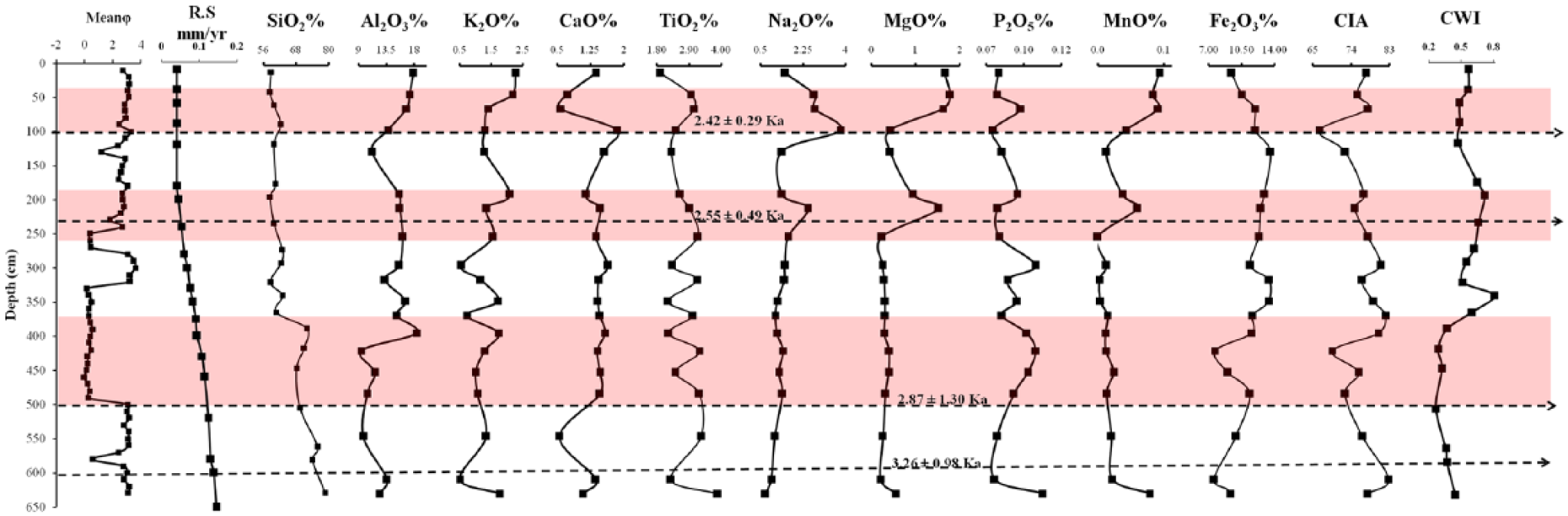
Vertical distribution of major oxides (%), CIA and CWI of PL-V lithosection with OSL dates.
Major oxides (%) and trace elements (ppm) distribution of PL-V palaeochannel sediments.

CIA: Chemical Index of Alteration.
The Palar River (PR)
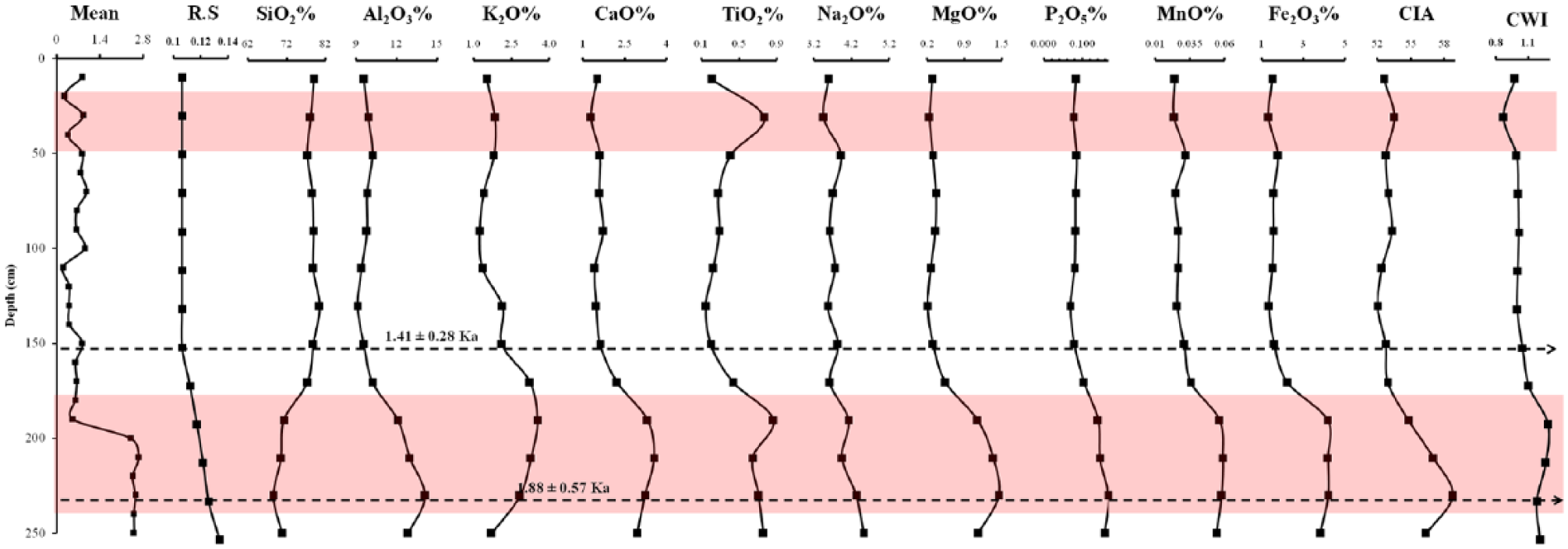
The late-Holocene sedimentary sequence is exposed in the middle reaches of the Palar River near Arcot, where the palaeochannel is connected to the modern channel. Unit 1 (1 m thick) is characterized by laminated fine sand, silt and mud (Sh) with a sheet-like geometry and is age dated to 1.88 ± 0.57 ka. Unit 2 consists of the intercalation of coarse sediments, planar cross beds (Sp), gravels with planar cross bed (Gp) and pebble-rich layer indicating an eroded surface, and the depositional age of this unit is 1.41 ± 0.28 ka. Unit 3 is predominantly characterized by cross bedded medium to coarse sand (Sp) coupled with randomly distributed clay lenses. The topmost layer of this sequence is a 10-cm-thick fine sand unit. The major facies in the lithosection are Sh, Sp and Gp as these occur as subordinate lithofacies (Figure 4). This association of facies can be traced over distances of several hundred metres along the present Palar River. The trilinear diagram shows that the sediments are predominantly sand and silty sand (Figure 5).
The sediment samples of PR-1 reveal that the major element content varies in the following order of abundance: SiO2 > Al2O3 > Fe2O3 > CaO > K2O > MgO > Na2O > TiO2 > P2O5 > MnO (Table 5, Figure 12). The SiO2 content in the PR sediments shows a strong positive correlation Al2O3 (R2 = 0.98), K2O (R2 = 0.65), CaO (R2 = 0.90), TiO2 (R2 = 0.657) and P2O5 (R2 = 0.97; Figure 8). During 1.88 ± 0.57–1.44 ± 0.28 ka, a decrease in SiO2 content with increases in all major oxides, CIA and CWI is noted. Post 1.44 ± 0.28 ka, an increase in SiO2 with decrease in all major oxides, CIA and CWI is noted. The A–CN–K plot of the modern Palar River reveals weakly weathered sediments (Figure 7).
Major oxides (%) and trace elements (ppm) distribution of PR (Palar River).

CIA: Chemical Index of Alteration.
Vertical distribution of major oxides (%), CIA and CWI of PR lithosection with OSL dates.
Discussion
Fluvial depositional settings
Rivers and palaeochannel deposits are one of the most important proxies for palaeoenvironment reconstruction (Chakraborty et al., 2010; Singh et al., 2016). Sediment laminations or layers along with the grain size distribution can be described in the sedimentation style, energy and their amplitude (Tyagi et al., 2012). These studies incorporate stratigraphical studies of the deposits in a naturally exposed bank or gully sections or in trenches. In this study combination of geochemical data has provided important insights for fluvial stratigraphy and depositional settings. The fluvial architecture was reconstructed by Resmi et al. (2016), based on the remote sensing, digital elevation model, fluvial architecture, OSL chronology and tectonic activity on the Palar River and its palaeochannels suggesting that the river has undergone episodic migration towards the south (Figure 13). However, not only Palar River but also the stream channels adjacent to the Mulki Pulicat Axis (MPA) are also undergoing migration (Subramanya, 1996). Therefore, we inferred that the palaeochannels presently draining in the southern side of the present-day Palar River are older and are not the palaeochannels of the Palar River. Since the Palar River is moving towards south, the palaeochannels of the active river are in the northern side. Presently, the palaeochannel of the old Palar River is occupied by a narrow channel and the present-day Palar River is wide and a braided river system.
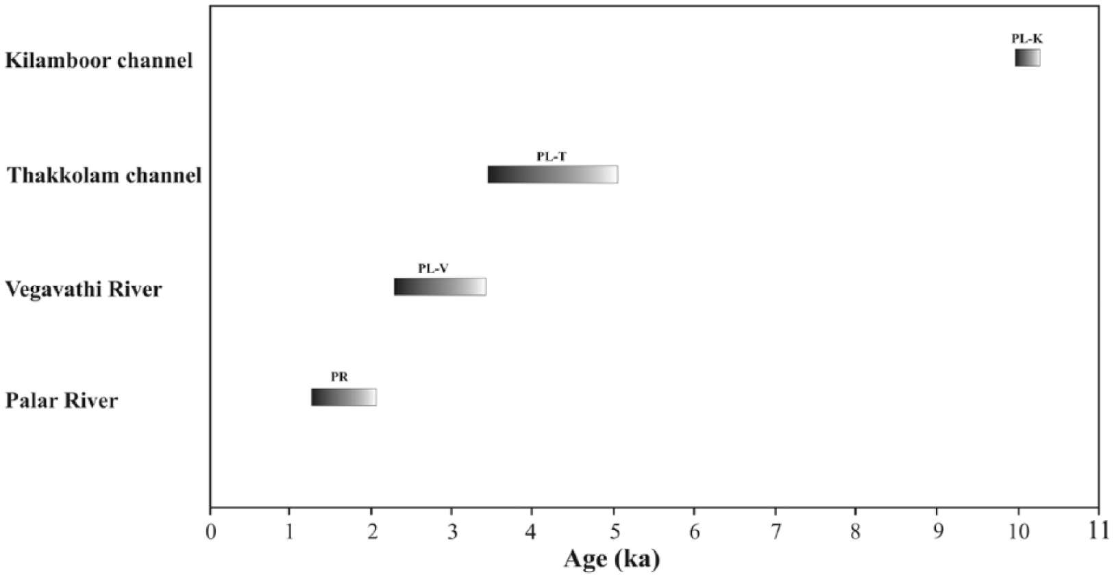
OSL chronology of palaeo-river generations PL-K (Kilamboor Channel), PL-T (Thakkolam Channel), PL-V (Vegavathy River), and PR (Palar River).
The PL-K section was not a part of the earlier Palar River basin, but in present-day condition it is part of the Palar River drainage basin. However, this particular section with predominantly clay deposit is situated in the southern side of the modern Palar River. The prevalence of fine-grained sand with clay indicates their deposition under stagnant/reducing water conditions, and the section is OSL dated to 10.09 ± 1.6 ka. The PL-T section is the oldest palaeochannels of the Palar River and is dominated by pebbly, coarse sand units with high-energy deposition environment (association of facies such as Sp, St and Gp). Extensive coarse-grained sand bodies are found to occur laterally and can be traced to a longer extent. Lack of clay layers with variation in grain size resemble typical braided river system (Miall, 1996). The OSL chronology suggests that the rate of sedimentation is comparatively high and the average sedimentation rate is 0.09 mm/yr.
In PL-V, the association of facies such as Gms, St and Sh signifies the debris flow in the lower unit, indicating relatively high-energy debris channel flow with pebbles pointing to a rapid uplift and avulsion caused by tectonic disturbances. From 2.55 ± 0.49 ka, OFs with ripples marks and desiccation cracks indicate a slow change in hydrography, decrease in discharge, and inert meandering deposits, which are the signatures of channel avulsion (Bridge, 2003; Chamyal et al., 2002). The entire deposition reveals strata sets exhibiting channel fill by vertical aggradations. Here, overbank deposits are coupled with periods of aggradations, weaker monsoon and a meandering river palaeoenvironment suggesting dry environment conditions.
The present channel lithosections show a transition between high- to low-energy river flow (facies assemblage of Sh, Sp, Sl and Gp). Even though there is shallow water deposit (Sh) which points towards dry environmental condition, high-energy deposition is also inferred in this section because of the random distribution of pebbles and gravels which suggest a probability of short-term, high discharge of water and sediments (flash flood deposit). A rise in the sediment load disproportional to the water discharge may be the reason for the river to aggrade and excessively widen its channel (Allen and Leeder, 1980; Best, 1996).
Climate interpretation; inference from geochemical proxy
Climate and rainfall have a major role in chemical weathering processes, which initiates chemical weathering and it increases the intensity of major chemical reactions (Blands and Rolls, 1998; Sun et al., 2010). Usually, in warm and humid climate, the rate of weathering is high because of chemical reactions, and is higher than cold and dry climate (Achyuthan et al., 2014; Babeesh et al., 2017a; Sun et al., 2010a). However, this study reveals that a change in discharge and/or sediment load may be because of a decrease in discharge and/or monsoonal fluctuations in the upper catchment (Kale, 2007), or because of high channel mobility (Sun et al., 2010) or because of avulsions that are climatically driven (Resmi et al., 2016; Singh et al., 2016). The ratio of soluble to insoluble chemical elements in a river and palaeochannel section sediments can serve as indicators of the chemical weathering conditions in that particular region (Chakraborty et al., 2010), especially to precipitation and monsoonal fluctuations (Singh et al., 2016). All the palaeochannels are dry and have well-exposed lithosection. Generally, in warm and wet climate conditions, elemental ratios of K/Al, Mg/Al and Ti/Al in the sediments are high (Chen et al., 2013; Gayantha et al., 2017; Sun et al., 2010) and elements such as Fe and Mn are subject to benthic redox conditions (Gayantha et al., 2017; Haberyan and Hecky, 1987). Moreover, the ratios of Mn/Al and Fe/Al are high during the dry periods (Sun et al., 2010).
In PL-K section, prior to 10.09 ± 1.6 ka, an increase in clay content coupled with increase in Ti/Al, Fe/Al, Mn/Al, Na/Al and Mg/Al and a decrease in Si/Al and Ca/Al along with a decrease in CWI values are noted. From the higher CIA, Rb/Sr ratio and decreasing CWI value, we inferred that prior to 10.09 ± 1.6 ka period, the area experienced an intensified monsoon phase with high weathering. This is further corroborated by the lower values of the major oxides CaO, MgO, TiO2 and K2O. Moreover, higher values of CaO/MgO, Na2O/K2O and Na2O/Al2O3 ratios also reflect the intense weathering during that period. Subsequent to 10.09 ± 1.6 ka together with the high values of elemental ratios such as Ti/Al, K/Al, Mg/Al, Ca/Al, Na/Al and K/Al, CWI and decreasing CIA values with high sand content are noted. Furthermore, post 10.09 ±1.6 ka period, Si/Al, Ti/Al, Mn/Al, Ca/Al, Na/Al, ratios and CWI exhibit a gradual increase (Figure 14). These variations point towards an increase in CWI but a decrease in CIA and Rb/Sr ratio indicating a decrease in rainfall during this period.

A minerogenic elemental ratios of Si/Al, Ti/Al, Fe/Al, Mn/Al, Mg/Al, Na/Al, P/Al, K/Al and P/Al of PL-K lithosection.
The elemental oxide concentrations prior to 4.83 ± 0.77 ka reveal an increase in Si/Al, Fe/Al, Na/Al, K/Al and CaO/MgO and CWI value. While a decrease in Mn/Al, Mg/Al and CIA value is also noted (Figure 15), indicating a reduction in the monsoon precipitation. Significant increase in soluble elemental oxides Al2O3, MgO, CaO and Na2O and lower levels of immobile elements in the lithosection during 4.83 ± 0.77–3.59 ± 0.63 ka signify a progressive increase in chemical weathering. This inference is corroborated with the increase in values of Si/Al, Mg/Al, Ti/Al, Fe/Al, Ca/Al, Na/Al, Mn/Al, K/Al, CaO/MgO and CWI. These findings reveal that chemical weathering in mid-Holocene period is intense with a decrease in the rate of sedimentation and NEMR. This observation is further supported by low Rb/Sr and Ba/Sr ratios. Post 3.59 ± 0.63 ka, fluctuations in elemental concentrations with high sand %, K/Al and Ti/Al ratios indicate strong weathering in the catchment. Lower CaO/MgO ratios also point to lower temperature and increase in precipitation in the area, resulting in a wet condition. This is further supported by low levels of Mn/Al and Fe/Al coupled with increased value of Rb/Sr and Ba/Sr.
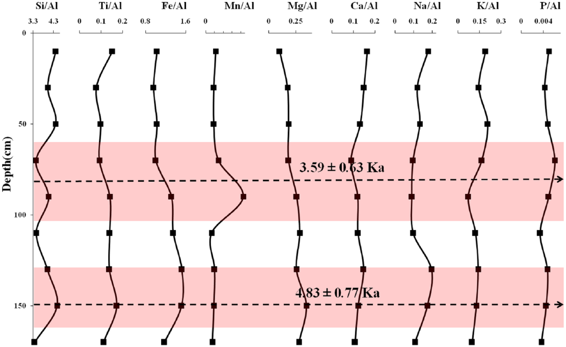
A minerogenic elemental ratios of Si/Al, Ti/Al, Fe/Al, Mn/Al, Mg/Al, Na/Al, P/Al, K/Al and P/Al of PL-T lithosection.
In Vegavathy River (PL-V) section, the upward declining trend of sand, silt and comparatively low-intensity elemental ratios (K/Al, Mg/Al and Ti/Al) imply a decrease in rainfall intensity followed by dry conditions (Figure 16). This argument is further corroborated with the thick OF deposits, mud cracks and rootlets supported by the relatively high levels of Mn/Al and Fe/Al ratios. The period between 3.26 ± 0.98 and 2.87 ±1.30 ka reveals a morphological change that occurred in the Vegavathy River, that is, rapid upstream avulsion followed by fining upward succession with OFs and mud cracks. The decreasing trends of elemental ratios K/Al, Mg/Al, Ca/Al, Na/Al, CaO/MgO, Ti/Al, CIA and CWI are also noticed during this period and this is because of the overall weakening of rainfall. This is further supported by the high Mn/Al and Fe/Al ratios (Figure 16). However, because of upstream avulsion, the grain size and rate of sedimentation are high. Furthermore, ameliorated conditions prevailed between 2.87 ± 1.30 and 2.55 ± 0.49 ka because of continued upstream avulsion followed by upstream fining upward succession. A significant decrease in Si/Al, Ti/Al, Mg/Al and highly varying ratios of Fe/Al, Ca/Al, Na/Al, k/Al and CWI with an increase rate of sedimentation confirm tectonic disturbances in the dry region. However, since 2.55 ± 0.49–2.42 ± 0.29 ka, the rate of sedimentation and SiO2 content are low and this is reflected by high CIA values and Al2O3 content. The decreasing trends in elemental ratios (K/Al, Mg/Al and Ti/Al) with high CIA value suggest relatively intense chemical weathering in the catchment area (Figure 16). Post 2.55 ± 0.49–2.42 ± 0.29 ka, a prominent increase in Al2O3, K2O, TiO2, Na2O, MgO, MnO, CIA and CWI with a decrease in SiO2 content and sedimentation rate and low CaO/MgO, Rb/Sr and Ba/Sr ratios are observed indicating a decrease in precipitation and NEMR intensity.

A minerogenic elemental ratios of Si/Al, Ti/Al, Fe/Al, Mn/Al, Mg/Al, Na/Al, P/Al, K/Al and P/Al of PL-V lithosection.
Furthermore, in the Palar River lithosection a significant increase in major oxide content is noted between 1.88 ± 0.57 and 1.41 ± 0.28 with high ratios of K/Al, Mg/Al, Ti/Al, CIA, Rb/Sr and Ba/Sr values that indicate an increase in rainfall (Figure 17). A sudden shift in the elemental concentration is noted post 1.41 ± 0.28 ka. However, after 1.41 ± 0.28 ka a decrease in rate of sedimentation and a decrease in K/Al, Mg/Al and Ti/Al ratios indicate an overall weakening of rainfall. Low values of CaO/MgO is also noted in the entire section, suggesting a decrease in the precipitation and monsoon intensity. Significantly higher concentrations of all soluble and insoluble elements together with high CWI suggest a decrease in weathering and monsoon intensity since the late-Holocene period.
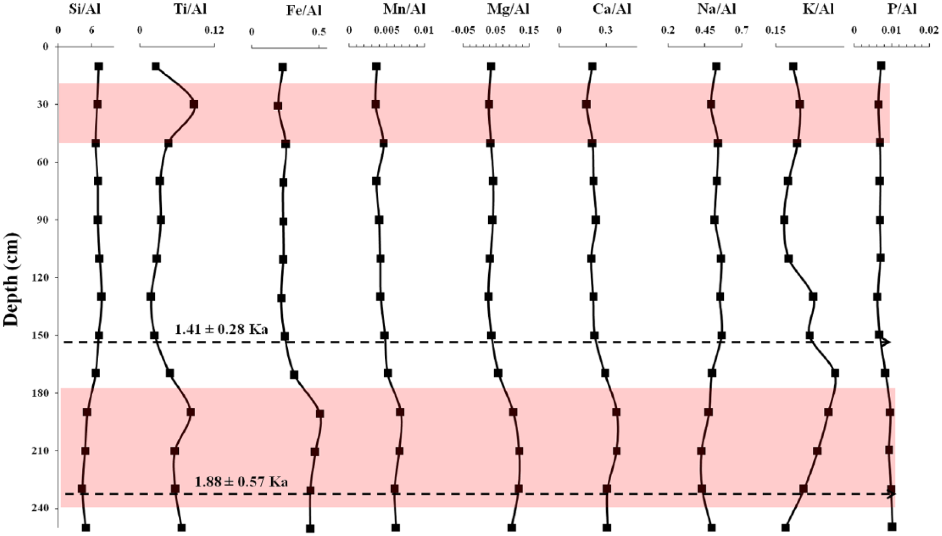
A minerogenic elemental ratios of Si/Al, Ti/Al, Fe/Al, Mn/Al, Mg/Al, Na/Al, P/Al, K/Al and P/Al of PR lithosection.
Palaeoclimatic inferences
In this study, an integration of sedimentology and geochemical data supported by OSL dates reveal the fluctuations in the intensity of NEMR precipitation during the Holocene period in and around the Palar River basin. Based on our data collected, we identify a humid, intensified monsoon phase from PL-K lithosection prior to ~10 ka marked as Phase 1, indicating a high runoff condition because of intense precipitation. Subsequent to Phase 1, there is an increase in temperature and dry conditions and this is marked because of the decrease in NEMR spell, designated as Phase 2. Around ~4.83–3.59 ka (Phase 3: PL-V), the geochemical and elemental ratio record points towards a decreasing trend of NEMR. However, prior to Phase 3, we observed a dry phase (undated, Figure 18) because of the change in elemental concentrations. The geochemical proxy subsequent to ~3.59 ka (Phase 4) reveals a sudden increase in the intensity of NEMR. Resmi et al. (2016) noted that flash flood events also occurred during this period, which might have also led to migration of the Palar River. Phase 5 is marked by a decline in NEMR precipitation resulting in an intense dry phase coupled with rapid upstream avulsion because of neotectonic activity and this was around the period 2.42 ± 0.29–3.26 ± 0.98 ka. The variations in elemental concentration prior to 1.88 ka also suggest a dry phase. Hence, from ~3.26 ± 0.98 to 1.88 ka, a continuous dry phase prevailed or Phase 5 climatic conditions continued (Figures 4 and 18). The geochemical variations in major oxides and its elemental ratios reveal an amelioration in the intensity of NEMR since 1.88–1.44 ka which has been marked as Phase 6. From 1.44 ka to the present, the lowered elemental solubility and mobility reflect periods of weaker or decline in NEMR during the late-Holocene and is marked as Phase 7 (Figure 18). Hence, it is observed that since the early Holocene period (>10 ka), the intensity of NEMR continuously declined with short periods of intense rainfall and longer periods of weaker NEMR precipitation resulting in an overall lengthier period of dry conditions.
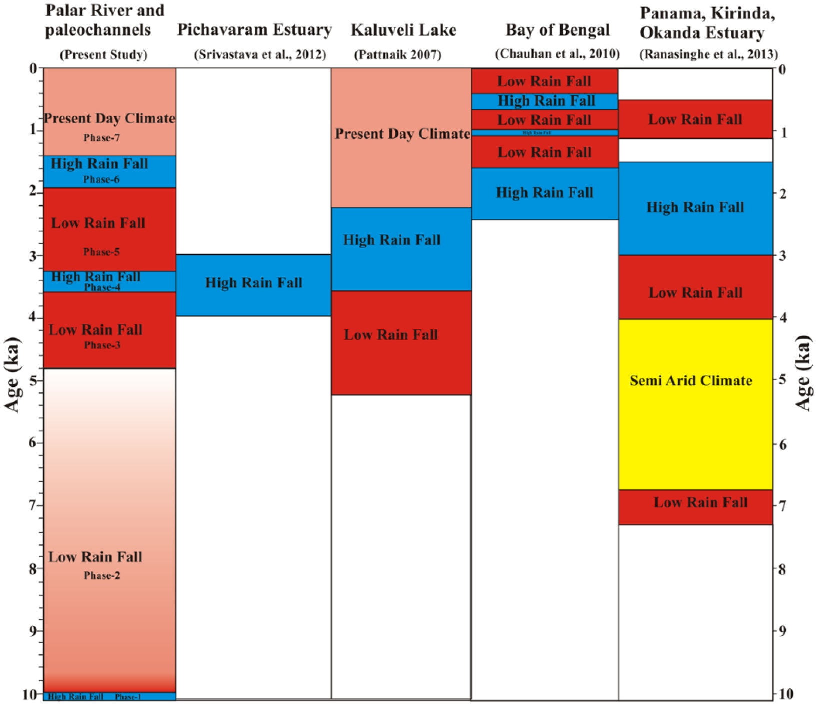
Schematic diagram of the NEMR records during the Holocene from the Palar River region. It is observed that the present-study data generally match well with the other sites that receive NEMR; however, there are variations observed and this is probably because of the distribution pattern and intensity of NEMR at different sites.
A comparison with regional palaeoclimate data
NEMR-dominated region
Only limited studies have been carried to reconstruct the NE (winter) monsoon. Ranasinghe et al. (2013), using chemical, biological, mineralogical and physical proxies in coastal sediments from Panama, Okanda and Kirinda estuary, suggest intervals from >7.3 to 6.75, 4 to 3 and 1.1 to <0.5 ka that were marked with decreased NEMR; short wet intervals occurred around 6.5–6.25 ka and semi-arid intervals ~6. 25 and 4.6 ka. The data from the Bay of Bengal indicate an increase in NEMR (Chauhan et al., 2010) because of the enhanced flux of chlorite contributed to the Bay of Bengal waters during 2.2–1.8 ka, 1 ka and 0.4–0.65 ka, since the chlorite clay influx is related to NEMR and this period is marked as a wet phase. In Kaluveli Lake, near the Palar River, the period between 5.25 ± 0.28 and 3.39 ± 0.22 ka illustrates higher smectite/kaolinite (S/K) ratio as a result of the decrease in NEMR (Pattanaik, 2009), while in 3.39 ± 0.22 ka, the variations in S/K ratios suggests a prevalence of the intensified NEMR and from 2.24 ± 0.32 ka S/K ratios suggests the establishment of the present-day climate. Application of thecamoebians data and geochemical investigation of Pichavaram estuary of southern India indicate that a wet phase persisted since 4–3 ka (Srivastava et al., 2011; Figure 18). Figure 18 also reveals that the response of the various sites (Chauhan et al., 2010; Pattanaik, 2009; Ranasinghe et al., 2013; Srivastava et al., 2011) to the intensity of NEMR is also varied. But overall, it is observed that since the early-Holocene period, wetter conditions declined to a more drier environment probably because of the weakening and reduction in the intensity and amount of NEMR. Short pulses of wetter conditions prevailed, cooling the region for a brief period.
SWMR-dominated region
Holocene SWMR strengthening because of increased solar insolation has also been inferred from different proxy records: (1) Fleitmann et al. (2003) used isotope data from stalagmites in southern Oman that signify an increase in monsoon (SWM) precipitation between 10.3 and 8 ka and subsequent decrease and (2) a detailed Globigerina bulloides record indicating upwelling, from the Oman coast, demonstrates a intensified monsoon during the early Holocene, with occurrences of distinct intervals of weak summer monsoon (Gupta et al., 2003). A regional dissimilarity in climate change is observed during the Holocene over northern India, related to the westerlies versus monsoon interactions (Prasad and Enzel, 2006).
However, recent studies, especially in Southern Peninsular India, indicate a rather composite and complex regional pattern of early-Holocene climate change (Achyuthan et al., 2014; Bhattacharya et al., 2015). Because of the spatial inhomogeneity of the Indian monsoon (both NEMR and SWMR), the tropical-midlatitude connections can disrupt the monsoon pattern (Gadgil, 2003; Prasad and Enzel, 2006). In this discussion, areas experiencing SWMR climate regime have been reviewed to delineate the variability in SWMR and NEMR. Summarizing, the following points emerge: (1) stable isotope (δ13C on organic matter) investigations on peat deposits in Nilgiris (Sukumar et al., 1993) suggest that the SWMR reached its highest between ∼10 and 5 ka and was followed by a period of dry and weakened SWMR during ∼5–2 ka. (2) Kale (2007) recognized the early-Holocene monsoon optimum (9–6 ka) phase, which was characterized by the revival of fluvial activity in the Indian subcontinent that increased more weathering and fluvial erosion in various parts. (3) A pollen and magnetic susceptibility data record from Pokoot Lake indicates that the period ~3.1–2.5 ka is a wet phase, and in ~2.5–1 ka the vegetation was sparse and the rainfall was low (Bhattacharya et al., 2015). Hence, the data in this study on the Palar River and the palaeochannel data match well with the regions receiving the NEMR. Since the Southern Peninsular India receives both the monsoons (SWMR and NEMR), we also compared the Palar River data with SWMR records and observe an antiphase behaviour of the NEMR and SWMR as suggested by Chauhan et al. (2010).
Conclusion
In summary, the following major points emerge from this study:
This work highlights for the first time NEMR fluctuations from the early-Holocene period that are presented based on sediment records supported by OSL dates and geochemistry.
This study reveals a robust palaeoenvironmental record and sedimentary depositional history preserved in the palaeochannels and Palar River based on the OSL, textural and geochemical data.
The sediments of the Palar River and the palaeochannels illustrates the depositional history extending from ~10 ka to the present. This study suggests intense NEMR precipitation and wetter conditions that extend from >10 ka (Phase 1), 3.59–3.26 ka (Phase 4), to 1.88–1.44 ka (Phase 6). These phases can be regionally correlated with the wetter pulses because of higher intensity of NEMR.
A decrease in the NEMR precipitation and drier conditions from <10 ka (Phase 2), ~4.8–3.59 ka (Phase 3), ~3.26–1.88 (Phase 5), to 1.44 to present (Phase 7) persisted and these phases can also be regionally correlated with the drying trend which receive NEMR.
Our study indicates an antiphase behaviour between the NEMR-dominated region and SWMR, that is, an inverse coupling existed between NEMR and SWMR in Southern Peninsular India since the early Holocene period.
Footnotes
Acknowledgements
The authors are grateful to the reviewers for the constructive comments received that significantly helped in improving the presentation of the manuscript.
Funding
This study was supported by the Department of Science and Technology, New Delhi, project no DST (WOS-A)-SR/WOS-A/ES-34/2012 granted to M.R.R.