



Abstract
The sparsity of long-term reliable climatic records hampers our understanding of human–environment interactions in the semi-arid Hexi Corridor, NW China. Here, we present a late-Holocene pollen record from a small alpine lake, Tian’E, in the western Qilian Mountains. The chronology is provided by nine accelerator mass spectrometry (AMS) 14C dates from terrestrial plant remains. The ratios of Artemisia and Amaranthaceae (A/C) are used to reconstruct the history of regional humidity: An unstable climate occurred during 1530–1270 BC; there were three relatively wet periods, at 1270 BC–AD 400, AD 1200–1350, and AD 1600–present; and there were two dry periods, from AD 400 to 1200 and from AD 1350 to 1600. Comparison with tree-ring data indicates that continuous droughts were responsible for the abandonment of several archaeological sites and ancient cities in the region, including the major city of Dunhuang, which was abandoned in AD 1372 and AD 1524 for nearly 200 years.
Introduction
The late-Holocene is an important interval because it provides the climatic background for interpreting the increasing pace and impact of human activity, as well as for exploring possible future climate change. Studies of various climatic archives and proxies have provided information on the processes of climate change during the ‘Medieval Warm Period’ (‘MWP’), ‘Little Ice Age’ (‘LIA’), and the ‘Current Warming Period’ (‘CWP’). Research into late-Holocene climate change in the northeastern Tibetan Plateau has used various archives and proxies, including ice cores (Qin et al., 2014; Wang et al., 2002), lake sediments (Chen et al., 2009; Li et al., 2015), pollen assemblages (Chen et al., 2006; Li et al., 2011a), and tree-rings (Liu et al., 2010; Yang et al., 2014a).
The Qilian Mountains, on the northern margin of the Qinghai-Tibetan Plateau, are situated on the boundaries of the arid zone of northwestern China, the eastern monsoon region, and the Tibetan Plateau region. The area is climatically sensitive and the pattern of climatic change is complex. The northeastern Tibetan Plateau has exhibited a distinctive vegetation response to climate change. Tree-ring records from the Qilian Mountains (Zhang et al., 2009) suggest that the region was affected by the Asian Summer Monsoon before AD 1300, by strong westerly winds during AD 1450–1750, and by both systems after AD 1750. In the Qinghai Lake area, in the northeastern part of the Tibetan Plateau, the East Asian Summer Monsoon gradually weakened during the Holocene (Liu et al., 2016b). Differences between climatic records from the monsoon marginal region of the Tibetan Plateau (Liu et al., 2016a) may be caused by different chronological models, or they may reflect the influence of both the monsoon system and the westerly circulation. Because of its geographical location and climatic sensitivity, the region is especially significant for reconstructing and interpreting climate change in arid northwest China. Many paleoenvironmental studies have been carried out in the area, including of tree-rings (Hou et al., 2011; Kang et al., 2003; Liu et al., 2009; Tian et al., 2009), precipitation and temperature reconstructions (Niu et al., 2016; Zhang et al., 2011), ice cores (Dong et al., 2017; Qin et al., 2014), sporopollen (Herzschuh, 2007; Herzschuh et al., 2006; Ji et al., 2015), and modern pollen in topsoil (Lu et al., 2004; Ma et al., 2009). However, most of these studies were based on either long or short timescales, and were mainly focused on the central and eastern regions of the Qilian Mountains. The western region has few paleoclimatic records, and more paleoclimatic data are needed to better understand the regional climatic evolution.
The Hexi Corridor region in China (37°15′–41°30′N, 92°21′–104°45′E), which is in northwest Gansu Province and to the west of the Yellow River, was the most important routeway for the ancient Silk Road. During the late-Holocene, the climate became drier, as shown by lowered lake levels and sparse vegetation coverage (Li et al., 2008); specifically, there was a trend toward increasing aridity in the margin of the northwestern Tengger Desert, associated with a gradual strengthening of aeolian activity, during 3000–550 BC (Long et al., 2007). The intensity of human activity in the region since the Bronze Age varied considerably, probably in response to climatic fluctuations, as indicated by the archaeological record (Xie et al., 2009); Mischke et al. (2017) show that the decline of the Loulan Kingdom resulted from a man-made environmental disaster rather than from changing climate, based on analyses of lake sediments from Lop Nur in the Tarim Basin and a review of published records; in addition, the Silk Road was occasionally closed during the historical period. However, the climatic background to human activity in the region during the late-Holocene has not been addressed in detail. As well as being influenced by climate, human activity itself may have resulted in environmental degradation which increased the risk of dust storms (Xiao et al., 2002). Therefore, during the late-Holocene, the region was characterized by the complex interplay of climate and environmental changes and fluctuations in human activity.
Pollen analysis is one of the most important and widely used methods of paleoclimatic reconstruction (Wang and Wang, 1983). In addition, lacustrine sediments are excellent multichannel recorders of paleoenvironmental information (Birks et al., 2012), and frequently provide high resolution and continuous records of terrestrial environmental changes (Lowe and Walker, 1997; Shen et al., 2004). Here, we present the results of pollen analysis of a well-dated sediment core from a small alpine lake located in a very dry area, currently dominated by alpine meadow and desert steppe, in the western section of the Qilian Mountains. Our aims are to reconstruct the regional climate change during the past 3500 years and to provide a climatic context for interpreting variations in human activity in the late-Holocene along the Hexi Corridor.
Study area
The Qilian Mountains are in the northeastern Qinghai-Tibetan Plateau, with the southern part in the Qaidam Basin and the northern part in the Hexi Corridor. The Hexi Corridor is the most important routeway of the ancient Silk Road (Figure 1), which is bordered by the Tengger Desert and Badain Jaran Desert to the north and by the high Qilian Mountains to the south. Tian’E Lake (39°14′20″N, 97°55′26″E, 3012 m a.s.l.) is an alpine lake located in the western part of the Qilian Mountains (Figure 1). The lake is ca. 0.12 km2 in area and has a water depth of ~14.5 m. A climate record is available for Sunan meteorological station (150 km from the lake, at 2330 m a.s.l.). For the period from 1981 to 2010, the regional average annual precipitation was ~267 mm and the evaporation was ~2200 mm; the mean January temperature was −9.4°C and the mean July temperature was 16.8°C. The western side of Tian’E Lake is occupied by the main peak of the Qilian Mountains which has a modern glacier, the Qiyi Glacier (Figure 1b).
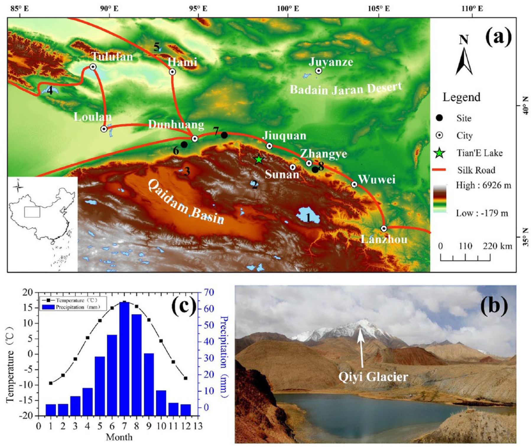
Environmental setting of the Tian’E Lake area. (a) Topography of the study area, and routeway of the ancient Silk Road. The location of Tian’E Lake is indicated by the green star, and the sites mentioned in the text are shown by numbers: (1) Qinghai Lake, (2) Hala Lake, (3) Sugan Lake, (4) Bosten Lake, (5) Balikun Lake, (6) Shouchang city site, (7) Suoyang city site, and (8) Donghuishan archaeological site. Inset map shows the location of the study area in China. (b) Tian’E Lake and the Qiyi Glacier. (c) Monthly temperature and precipitation at Sunan meteorological station during 1981–2010.
Several vegetation zones can be identified along the altitudinal gradient in the western part of the Qilian Mountains (Yi and Wang, 2013): from 1500 to 2000 m, a desert steppe zone dominated by Sympegma regelii, Salsola passerina, and Reaumuria soongorica; from 2000 to 2700 m, a dry shrub steppe zone dominated by Ajania fruticulosa (from 2000 to 2200 m) and Agropyron cristatum (from 2200 to 2700 m or higher); below 3900 m, a sub-alpine shrub meadow zone with meadow communities dominated by Kobresia humilis and Saxifraga, and shrub communities dominated by Salix oritrepha; and above 3900 m, an alpine cold-desert meadow zone dominated by Arenaria spp. and Cyperus spp.
The vegetation coverage of the Tian’E Lake region is limited and forest is absent (Figure 1b). The vegetation consists mainly of Achnatherum splendens, Leymus chinensis, and Agropyron cristatum, mixed with low-growing taxa such as Campanula in the arid area, and several wetland taxa, mainly Phragmites, grow around the lake.
Materials and methods
Fieldwork
A 621-cm-long sediment core (core TE) was collected from the center of Tian’E Lake in January 2015 using a piston corer; the coordinates of the site are 39°14′20″N and 97°55′26″E, and the altitude is 3012 m a.s.l. The sample was transported to the laboratory in a frozen state, and then sampled at a 1-cm interval; the samples were then freeze dried.
Lithology and chronology
Figure 2 shows the lithology of core TE (Yan et al., 2018). According to the sediment structure, color, and flora and faunal characteristics, the upper 621 cm of the core can be divided into four intervals: 0–55 cm – dark brown clay with occasional shell-like biological remains; 56–155 cm – grayish lacustrine sediment containing a large number of calcite tubercles and algal residues; 156–560 cm – dark brown clay with multiple sandy interbeds, with abundant terrestrial plant debris in the sandy interbeds; 560–621 cm – grayish lacustrine sediment containing many plant calcite tubercles.

Scanning images of core TE from Lake Tian’E.
Nine samples of terrestrial plant macrofossils were used for accelerator mass spectrometry (AMS) radiocarbon dating. The samples were pretreated with the acid-alkali-acid treatment method (Olsson, 2016) and measured in Peking University. All dates were calibrated to calendar years using Calib 6.0.1 (Stuiver et al., 2010), and finally, an age model was constructed by linear interpolation between the calibrated dates (Figure 3). The results are shown in Table 1.

Age model for core TE from Tian’E Lake (1σ calibrated age).
Results of AMC 14C dating of core TE.

Pollen analysis
Pollen grains were extracted from 1–3 g dry samples using standard procedures (Faegri et al., 1989), including HCl, KOH, and HF treatments, and fine sieving to remove clay-sized particles. One Lycopodium tablet (containing ca. 20,848 grains or ca. 27,560 grains) was added at the beginning of the laboratory treatment to estimate the pollen concentration (Maher, 1981). Pollen grains were identified and counted using a Nikon ECLIPSE 80i optical microscope at ×400 magnification. The pollen sum was usually >300 terrestrial pollen grains. Pollen identifications were based on the Pollen Flora of China (Wang et al., 1995), supplemented by published photograph collections (Xi and Ning, 1994; Xu et al., 2015). Pollen diagram was generated using Tilia software (Grimm, 2011), and pollen assemblage zones were defined using stratigraphically constrained cluster analysis with CONISS, using all pollen types (Grimm, 1987).
Results
A total of 89 samples were analyzed for the 621-cm-long core TE. Because of the changes in sediment accumulation rate, different parts of the core were sampled at different resolution: the interval from 3 to 403 cm was sampled at less than 20-cm interval (35 samples), 403–523 cm at a 5-cm interval (23 samples), and 523–621 cm at less than 5-cm interval (31 samples). The highest time resolution was 15 years and the average resolution was about 40 years. We identified a total of 19 major pollen taxa. The main arboreal taxa were Picea and Betula, and the main herb taxa included Artemisia, Amaranthaceae, and Cyperaceae. Fern spores were almost entirely absent. The main aquatic pollen type was Phragmites; however, it is difficult to distinguish its pollen from that of the dryland grasses. The pollen assemblages were divided into four main zones based on CONISS (Figure 4), and they are described below. The A/C ratio is the ratio of Artemisia and Chenopodiaceae (replaced by Amaranthaceae) (APG, 1998), which has been widely used to reconstruct humidity in arid areas (Zhao et al., 2012b).
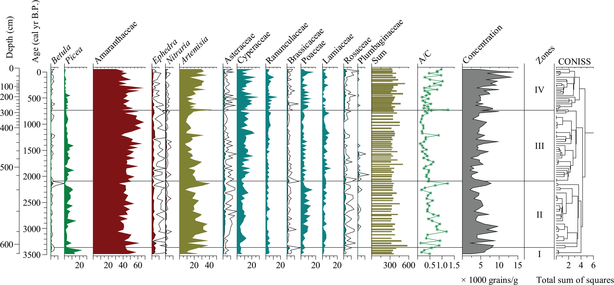
Pollen percentage diagram for core TE spanning the last 3500 years (open curves are ×5 times exaggeration of scale).
Zone I (608–621 cm; 1530–1420 BC)
This zone is dominated by Amaranthaceae (43.2–56.7%, mean 48.3%), Artemisia (9.1–24.7%, mean 17.5%), and Cyperaceae (mean 5.1%). Ranunculaceae (mean 3.8%), Ephedra (mean 3.8%), and Poaceae (mean 2.5%) are also represented. The main characteristic of the zone is that it has the highest tree pollen frequencies of the entire sequence, with Picea (mean 13.1%) the main tree taxon. The A/C ratio is rather variable (0.16–0.57), and the average pollen concentration is 5660 grains/g.
Zone II (530–608 cm, 1420–140 BC)
The zone is dominated by Amaranthaceae, with a range of 31.4–60.5% (mean 43.4%). Other herbs taxa are well represented, including Artemisia (7.1–40.4%, mean 24.3%), Cyperaceae (3.4–15.1%, mean 7.6%), Poaceae (1.6–14.7%, mean 6.3%), and Lamiaceae (0.6–5.9%, mean 3.1%), with significantly higher frequencies than in Zone I. Poaceae increases to a maximum, whereas there are decreases in Ranunculaceae (mean 2.5%), Ephedra (mean 2.6%), and Picea (mean 4.9%), compared with Zone I. Although the Betula frequencies are very low in this zone (0–3.7%, mean 0.5%), they reach a maximum for the entire sequence at 533 cm (200 BC). The average A/C ratio is ~0.59, which is significantly higher than in Zone I. The pollen concentration decreases significantly, to ~5460 grains/g, compared with the previous zone.
Zone III (288–530 cm, 140 BC–AD 1200)
Amaranthaceae (mean 50.7%) and Nitraria (mean 0.5%) are higher than in Zone II, and Amaranthaceae and Nitraria reach their highest values. There are decreases in Artemisia (mean 16.5%) and Poaceae (mean 3.3%) and increases in Cyperaceae (mean 11.3%), Ranunculaceae (mean 3.4%), and Lamiaceae (mean 4.3%), compared with Zone II. The tree pollen representation is low. The A/C ratio varies from 0.11 to 0.85. The pollen concentration decreases to its lowest value for the entire sequence; the range is 2350–9930 grains/g, with a mean of ca. 4700 grains/g.
Zone IV (3–288 cm, AD 1200–2000)
This zone is dominated by Amaranthaceae (mean 43.8%), Artemisia (mean 22.7%), and Cyperaceae (mean 12.7%), and in addition, Poaceae (mean 5.6%), Ranunculaceae (mean 4.6%), and Lamiaceae (mean 2.8%) are well represented. Ranunculaceae and Cyperaceae reach their highest values. Tree pollen frequencies are low. The A/C ratio varies from 0.18 to 1.23 and reaches its maximum value. The pollen concentration, which ranges from 3680 to 13,900 grains/g (mean 7110 grains/g), is higher than in Zone III.
Discussion
Pollen source area and vegetation evolution
Picea is the main tree pollen type within the studied 3500-year sequence from Lake Tian’E, as is also the case in Holocene pollen records from other sites in the eastern and central Qilian Mountains. Studies of modern surface pollen spectra from arid and semi-arid China indicate that Picea percentages in the desert region are very low (<5%), and that the long-distance transport of Picea pollen is also low (Chen et al., 2014; Li et al., 2005). Picea frequencies greater than 30% are commonly considered to represent forest vegetation (Yan et al., 2004). The Picea and Betula frequencies are generally very low in the sequence from Lake Tian’E, except that Picea is relatively well represented (10–20%) in Zone I, during 1530–1420 BC. Thus, we infer that there may have been a sparse occurrence of Picea close to the lake during this interval.
The fossil pollen spectra from Lake Tian’E are dominated by Amaranthaceae, Artemisia, and Cyperaceae after 1420 BC. Amaranthaceae and Artemisia are the main pollen types in the semi-arid and arid regions of NW China, and high frequencies usually indicate dry steppe or desert steppe (Li et al., 2005; Xu et al., 2007). The Artemisia and Amaranthaceae ratio (A/C ratio) is commonly used as an indicator of effective moisture in arid and semi-arid regions where Artemisia and Amaranthaceae are the dominant plants, for example, in Sugan Basin (Zhang et al., 2010), the Tianshan Mountains (Wei and Zhao, 2015), Qaidam Basin (Zhang et al., 2012; Zhao et al., 2008), and the Loess Plateau and surrounding deserts (i.e. Li et al., 2011b; Luo et al., 2010; Zhao et al., 2012a). A study of modern surface pollen spectra in NW China demonstrated a statistically significant relationship between the A/C ratio and humidity when the sum of the two pollen types exceeded 50%, with higher A/C ratios indicating more humid conditions in a semi-arid environment (Zhao et al., 2012b). The abundance of Artemisia and Amaranthaceae in the study region enables the use of the A/C ratio for the reconstruction of variations in regional effective humidity. Several studies have shown that the primary sources of Cyperaceae pollen are alpine meadows (Huang et al., 2015; Lu et al., 2011), where the pollen productivity of Cyperaceae is relatively high but the dispersal efficiency is low. However, Cyperaceae pollen may also be contributed by the wetland vegetation around the lake (Shen et al., 2006). If Cyperaceae pollen is contributed by the zonal vegetation, then it can be used as an indicator of a cool and wet climate (Huang et al., 2015; Luo et al., 2010; Zheng et al., 2008). At the study site, however, Cyperaceae pollen could be derived from both wetland plants and from the zonal alpine meadow, and thus, it is difficult to use Cyperaceae frequencies to differentiate hydrological (e.g. lake level) and temperature signals.
Poaceae is usually under-represented in pollen spectra and has a lower dispersal ability, compared with Artemisia and Amaranthaceae, in arid and semi-arid China (Luo et al., 2007). A study of surface soil pollen spectra showed that Poaceae frequencies were less than 30% in forest steppe and less than 10% in steppe and meadow (Huang et al., 2015). Since Phragmites is present around Lake Tian’E, it is likely to make as important a contribution to Poaceae in the pollen record as the upland grasses of the steppe zone.
The fossil pollen spectra (Figure 4) from Lake Tian’E are dominated by Amaranthaceae, Artemisia, and Cyperaceae. From 1530 to 1420 BC, very sparse Picea could have grown near the lake. After 1420 BC, a decrease of tree pollen suggests that Picea disappeared from this region, and the local vegetation was desert steppe dominated by Amaranthaceae, Artemisia, and Poaceae, which continued to the present day.
Climatic record of the western Qilian Mountains revealed by the pollen record from Tian’E Lake
The shift in regional vegetation from forest steppe to dry steppe at around 3.4 kyr BP, noted above, is consistent with pollen records from Qinghai Lake (Shen et al., 2005) and Genggahai Lake (Liu et al., 2016a). It is interpreted as representing a major climatic shift from warm and wet to cold and dry. The ratio of arboreal pollen and non-arboreal pollen (AP/NAP), which is a climate proxy, decreases continuously in the pollen record from Tian’E Lake (Figure 5e), indicating a deterioration of the regional forest vegetation and possibly climatic cooling associated with decreasing summer insolation (Zhao et al., 2011). The decreasing tree pollen representation in this region may have been caused by the disappearance of Picea in a colder environment. In addition, Artemisia and Asteraceae are indicative of moist habitats, whereas Amaranthaceae (Chenopodiaceae), Ephedra, and Nitraria are mainly desert plants in this region (Zhao et al., 2012a, 2012b). Therefore, the ratio of a combination of the former two taxa (Arte + Ast) to the latter three taxa (Am + Ep + Ni) is an effective moisture index (Figure 5d), and has a similar climatic significance and pattern of variation to the A/C ratio (Figure 5f).
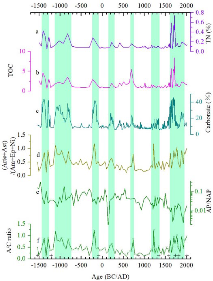
Selected paleoenvironment indicators from core TE from Lake Tian’E. (a)–(c) Total nitrogen, total organic carbon, and carbonate content (Yan et al., 2018); (d) ratio of Artemisia + Asteraceae to Amaranthaceae + Ephedra + Nitraria (Arte + Ast/(Am + Ep + Ni)); (e) ratio of tree pollen to non-tree pollen (AP/NAP) (Y-axis is a log scale); (f) ratio of Artemisia to Amaranthaceae (A/C). The shaded areas indicate stages of higher humidity. ‘+’ indicates AMS radiocarbon dates from terrestrial plant macrofossils.
The organic matter content of lake sediments depends mainly on the organic matter supply from terrestrial sources and from the productivity of aquatic organisms. Higher total nitrogen (TN) (Figure 5a) and total organic carbon (TOC) (Figure 5b) values in Lake Tian’E reflect higher biological productivity, which may be related to climatic conditions. A C/N ratio of about 12.4% indicates a mixture of aquatic and terrestrial organic matter (Kaushal and Binford, 1999) in the sediments of Lake Tian’E. Precipitation may be a limiting factor for the regional vegetation of the study area, and higher precipitation would probably lead to higher plant productivity, and thus potentially to an increased sedimentary TOC content. Notably, variations in the TOC content of the lake sediments of North China are interpreted as reflecting changes in precipitation (An et al., 2012; Zeng et al., 2013). The sedimentary carbonate content is mainly associated with evaporative processes and lake water salinity (Lan et al., 2013). In the sediments of Tian’E Lake, a higher carbonate content (Figure 5c) occurred during cold and moist intervals, such as from AD 1600 to 1750, in the ‘LIA’. Therefore, the higher carbonate content cannot be explained by the direct influence of temperature on the evaporation process, and it may instead be related to the increased supply of Ca2+ from the groundwater because of increased local precipitation or snowfall. Thus, the carbonate content at Lake Tian’E is more closely related to hydrological processes than to evaporation, and a lower carbonate content is likely to reflect less precipitation and thus to decreased Ca2+ input from groundwater.
Based on the variation of the proxies discussed above, the humidity changes in the Lake Tian’E area can be divided into four main stages: Stage 1 (1530–1270 BC) was an interval of unstable humidity conditions. There were large variations in the A/C ratio which may have been caused by significant temperature changes, and in addition, lower temperatures may have caused a recession of the trees and higher sedimentary carbonate content may reflect increasing regional precipitation or snowfall (Figure 5e and c). Stage 2 (1270 BC–AD 400) was characterized by relatively humid conditions. The high A/C ratio indicates high humidity but with a strongly decreasing trend from about 1100 BC. The A/C ratio was high at around 200–100 BC. Stage 3 (AD 400–1200) was an interval of significantly dry conditions. The minimal A/C ratios indicate a very dry interval which was interrupted by a brief wet period at around AD 750 (in the Tang Dynasty). Stage 4 (AD 1200 to present) was an interval of relatively wet conditions, except for a drought event from AD 1350 to 1600, as indicated by low A/C ratios (Figure 5f) and low (Arte + Ast)/(Am + Ep + Ni) ratios (Figure 5d). The interval of maximum carbonate content during AD 1600–1750 suggests prevailing wet conditions. In summary, the temperature and moisture proxies indicate a pattern of warm and dry and cold and humid climatic conditions in the western Qilian Mountains during the last 3.5 kyr.
Comparison of the paleoclimatic record from Lake Tian’E with those from the surrounding region
An oxygen isotope record from the Guliya ice core indicates significant temperature fluctuations at around 3.4 kyr BP (Thompson et al., 1997). Notably, the A/C ratio at Tian’E Lake (Figure 6j) exhibits large amplitude variations before 1270 BC, possibly also reflecting temperature instability. The summer monsoon may have significantly retreated since around 3.5 kyr BP (Dykoski et al., 2005; Wang et al., 2005), and it appears that both a weakened summer monsoon and decreased temperature led to forest recession in the eastern and central Qilian Mountains (Liu et al., 2016a; Shen et al., 2005a) and its disappearance in the western Qilian Mountains. In the Qinghai Lake area, multiproxy records, including a grain-size ratio (GSR) (8–50 µm/2–8 µm) (Liu et al., 2016b), lake levels (Chen et al., 2016), pollen assemblages (Shen et al., 2005), and a Summer Monsoon Index (SMI) (An et al., 2012), indicate an arid climate during this period. A record from Genggahai Lake (2858 m a.s.l.), in Gonghe Basin, also indicates the deterioration of forest vegetation from 2100 to 1100 BC, and thus a change to a cold and dry climate (Liu et al., 2016a). The increased carbonate content of the sediments of Lake Tian’E (Figure 6i) indicate a decreasing temperature and a trend of increasing precipitation after 1420 BC; lower temperatures are consistent with the lower δ18O values of the Guliya ice core (Figure 6f) (Thompson et al., 1997).
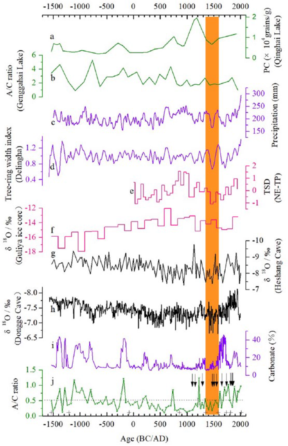
Comparison of paleoclimatic indices from core TE from Lake Tian’E with selected paleoclimatic records from North China. (a) Pollen concentration from Qinghai Lake (Shen et al., 2005), (b) A/C ratio from Genggahai Lake (Liu et al., 2016a), (c) reconstructed annual precipitation from the northeastern Tibetan Plateau based on tree-rings (Yang et al., 2014a), (d) tree-ring width index from Delingha (31-year mean) (Shao et al., 2010), (e) standard temperature deviation for the northeastern Tibetan Plateau (He et al., 2013), (f) oxygen isotope record from the Guliya ice core (Thompson et al., 1997), (g) oxygen isotope recorded from Heshang Cave (Hu et al., 2008), (h) oxygen isotope record from Dongge Cave (Dykoski et al., 2005), (i) carbonate content of core TE core (Yan et al., 2018), and (j) pollen A/C ratio from core TE core (this study). The shaded area indicates relatively dry conditions during AD 1350–1600. Dunhuang was abandoned at the same time. ‘+’ indicates AMS radiocarbon dates from terrestrial plant macrofossils, and ‘↓’ indicates drought events from local historical documents from the Hexi Corridor.
It is noteworthy that a humid event is recorded in the pollen record of Lake Tian’E at ~1000 BC, which may represent a similar event at 3 kyr BP recorded elsewhere in North China. For example, at Balikun Lake (1575 m a.s.l.), in Xinjiang Province, a relatively high A/C ratio occurs from ~3 kyr BP (Tao et al., 2010). The lake level of Hala Lake (4078 m a.s.l.) also decreased at the same time (Wünnemann et al., 2012), which may have been caused by reduced glacier meltwater production under a cooler climate. The record from Genggahai Lake, in the Gonghe Basin, indicates an interval of very dry climate at the same time, caused by a retreat of the summer monsoon system and cooler temperatures (Liu et al., 2016a). At Qinghai Lake, the SMI (An et al., 2012) and GSR (Liu et al., 2016b) indicate a relatively humid climate at ~1000 BC, and the high humidity recorded at the same time at Lake Tian’E is also consistent with a lake level maximum at 3 kyr BP in Juyanze Lake in the lower desert area (Jin et al., 2015). Therefore, the Lake Tian’E region may have received more precipitation at this time caused by a strengthened westerly circulation. In addition, the increased groundwater input, indicated by the higher sedimentary carbonate content, may have resulted from increased precipitation or snowfall. The lower δ18O values of the Guliya ice core (Figure 6f) (Thompson et al., 1997) at this time indicate a cooler climate.
Oxygen isotope records from Dongge Cave (Figure 6h) and Heshang Cave (Figure 6g) record an interval of monsoon retreat from AD 400 to 1200 (Dykoski et al., 2005; Hu et al., 2008). Temperature proxies from the Guliya ice core (Figure 6f) and the northeastern Tibetan Plateau (Figure 6e) indicate a warm climate compared with the previous interval. In the eastern Tianshan Mountains, the area of Lake Balikun decreased during 50 BC–AD 950 (Wang et al., 2014); however, a relatively humid climate is recorded at ~AD 750 at Lake Tian’E, based on the A/C ratio. At Sugan Lake (2793 m a.s.l.), a higher A/C ratio indicates a wetter climate during AD 550–700 (Zhang et al., 2010). A tree-ring width index (Figure 6d) also indicates a warm, humid climate during this interval. Li and Wang (2003) also suggested that rain and snowfall increased in the western part of the Qilian Mountains during the Sui and Tang Dynasties (AD 450–950). However, the record from Qinghai Lake (An et al., 2012; Liu et al., 2016b) indicates drier conditions because of a weakened Asian Summer Monsoon. A temperature proxy from the northeastern part of the Tibetan Plateau records a cooling trend (He et al., 2013), and the oxygen isotope record from the Guliya ice core (Figure 6f) also suggests low temperatures (Thompson et al., 1997), and thus a colder and potentially wetter climate because of the slightly decreased evaporation and increased rainfall and snowfall.
During AD 1200–1350 and AD 1600–present, a temperature proxy (Figure 6f) indicates a decreasing trend, and a moisture proxy (Figure 6j) also suggests a humid climate, in the westerlies-dominated region of North China. A cold and wet climate is consistent with the oxygen isotope record of carbonates from Sugan Lake during AD 1200–1880 (the ‘LIA’) (Qiang et al., 2005; Zhou et al., 2009). At Bosten Lake, in Xinjiang, the climate was generally cool and humid during the ‘LIA’ (AD 1500–1900), as indicated by a higher A/C ratio, higher pollen concentrations, a coarser sediment grain-size, and a lower carbonate content (Chen et al., 2006). In addition, the A/C ratio at Genggahai Lake (Figure 6b) and the pollen concentration at Qinghai Lake (Figure 6a) both increased during this period, indicating a humid climate.
The pattern of temperature and humidity changes in the monsoon marginal area described above may be closely related to changes in the monsoon system (Yang et al., 2014b). It has been suggested that more North Atlantic water vapor could have entered the arid region of Central and East Asia when the westerly winds were intensified, resulting in significantly increased precipitation (Chen et al., 2010).
Drought events and the abandonment of Dunhuang
At Lake Tian’E, the much lower A/C ratio during AD 1350–1600 (Ming Dynasty) indicates significant drought conditions (Figure 6j), and Dunhuang city, in the Hexi Corridor, was first abandoned in AD 1372, and was abandoned again in AD 1524 (Dunhuang City Annals Compilation Committee, 1994); the Dunhuang city was abandoned for nearly 200 years after AD 1539 (Chen, 2011). Dunhuang was not only located within a major traffic artery of the Silk Road but was also an important military garrison. Its abandonment may have been caused by warfare (Chen, 2011) or by drought conditions. During this period, tree-ring records (Figure 6c and d) from the northern Qinghai-Tibetan Plateau (Shao et al., 2010; Yang et al., 2014a) and the western Qilian Mountains (Gou et al., 2015) show a trend of decreasing precipitation, and the oxygen isotope records from Dongge Cave and Heshang Cave (Figure 6h and g) also indicate a trend of decreasing monsoon intensity (Dykoski et al., 2005; Hu et al., 2008). In addition, it was suggested that lakes in the Juyanze Basin became drier from the end of the Yuan Dynasty (AD 1271–1368) to the beginning of the Ming Dynasty (AD 1368–1644) (Liu, 1992). Moreover, Yu et al. (2011) also suggested drought conditions in the Hexi Corridor during the Ming and Qing Dynasties based on the collection and analysis of historical data. In addition, based on the drought-flood series of 19 sites in arid Northwestern China, it was found that the drought occurred frequently during the last 540 years and a major drought occurred at AD 1470–1570 (Wan et al., 2014). According to local documentary evidence, such as Dunhuang City Annals (Dunhuang City Annals Compilation Committee, 1994), Jiuquan City Annals (Sun, 2008), Minle County Annals (County Annals Compilation Committee of Minle County, 1996), and Jinchang City Annals (Local History Compilation Committee of Jinchang City, 1995), there were severe drought events in AD 1110 and 1520, AD 1161, AD 1293, and AD 1484. It was also found that some drought events were recorded in AD 1640, AD 1754, AD 1813, AD 1838, and AD 1868–1869 during the Ming and Qing Dynasty. In addition, more floods and sustained wet weather (such as ~50 days of rainfall in AD 1769) were recorded in the Qing Dynasty from Jinchang City Annals (Local History Compilation Committee of Jinchang City, 1995). Frequent droughts in the Hexi area during the Ming Dynasties were also recorded in Wuwei City Annals (City Annals Compilation Committee of Wuwei City, 1998). However, there are no direct historical records that Dunhuang city was abandoned because of droughts, while the occurrence of both a drier climate and wars in the region (Tulufan city) (Dunhuang City Annals Compilation Committee, 1994; Sun, 2008) could have contributed to its abandonment.
There are several additional records of city abandonment along the Silk Road caused by persistent drought conditions (Wang et al., 2003); for example, Suoyang city (Figure 1a, site 7) was abandoned in AD 1700, Shouchang city (Figure 1a, site 6) during AD 900–1000, and Loulan Kingdom (Figure 1a) was abandoned between AD 220 and 645. Even during the Bronze Age, human activity weakened after 1550 BC in the Donghuishan area (Figure 1a, site 8) (Li et al., 2010). Flad et al. (2010), using a new chronology, suggested that the occupation of Donghuishan site ceased at around 1400 BC.
Conclusion
A pollen record spanning the last 3500 cal. yr BP from the sediments of Lake Tian’E in the Qilian Mountains reveals a distinctive pattern of vegetation and climatic change. The regional vegetation changed from forest steppe to dry steppe at around 3400 cal. yr BP, caused by a weakened Asian monsoon. Thereafter, the main vegetation of the Lake Tian’E region consisted of desert steppe with Amaranthaceae and Artemisia, and alpine meadow with Cyperaceae, Poaceae, and Lamiaceae. The high TOC and TN content of the sediments indicates higher plant productivity under a humid climate, while the high carbonate content indicates higher Ca2+ input from groundwater because of increased local precipitation or melting snowfall.
During 1270 BC–AD 400, the high A/C ratio indicates high humidity, with a strong decreasing trend from ~1100 BC, but with high A/C ratios from around 200–100 BC. A low A/C ratio from AD 400 to 1200 indicates a dry climate, which was interrupted by a brief wet interval at ~AD 750. The moisture proxy suggests a humid climate during AD 1200–1350 and from AD 1600–present, with the A/C ratio indicating a drier climate during AD 1350–1600.
Persistent drought conditions would have significantly impacted the ancient cities close to the Gobi Desert. Dunhuang city was one of the main transport stations on the ancient Silk Road and an important military garrison. The Dunhuang city was first abandoned in AD 1372 and in AD 1524, and the abandonment lasted for nearly 200 years after AD 1539. The abandonment of Dunhuang city happened during a dry climatic interval recorded by the pollen records of Lake Tian’E in the Qilian Mountains and by tree-ring data obtained nearby.
Footnotes
Acknowledgements
We are grateful to the editor Dr Francis Mayle and two anonymous reviewers for their helpful comments and suggestions. We thank Dr Zhenting Wang for help with field work.
Funding
This work was funded by the National Key R & D Plan ‘Global Change and Response’ and the Key Special Project ‘Holocene Asian Monsoon Variation, Drought Evolution and its Driving Mechanism’ (Project no. 2017YFA0603403) and the National Science Foundation of China (Grant no. 41571182).