
Abstract
Water availability and climatic conditions profoundly control agricultural systems in different spatial-temporal conditions. Using new results of archaeobotanical research on the north Loess Plateau and extant macro-botanical data recovered from the eastern part of the north-south Loess Plateau, we investigated the ancient cropping patterns of different agrarian communities living in the marginal area of the East Asian monsoonal climatic zone. It indicated that the common millet (Panicum miliaceum)–based cropping pattern was dominant in the north Loess Plateau during around 3000–1800 cal. BC. However, there is a preference for foxtail millet (Setaria italica)–based farming combined with a certain amount of rice (Oryza sativa) cultivation by the archaeological humans on the south of the Loess Plateau during the same periods. We infer the diverse ways of crop management selected by late Neolithic human beings adapting to various water stress that probably underpinned different developmental trajectories of ancient civilizations on the Loess Plateau during mid-late Holocene.
Keywords
Introduction
Ecological environment, available resources, and intention of human beings to increase outputs are critical for effective food production by individual farmer or agrarian communities in the present as well as in the ancient times (Bockstaller et al., 2008; Melnyk et al., 2008; Moniruzzaman, 2015; Smit et al., 1996). Generally, archaeobotanical data can help to identify the diverse cropping patterns arranged by ancient human beings under different spatial-temporal conditions during the prehistoric periods (Hastorf and Popper, 1988). In this connection, crop assemblages recovered from the archaeological sites combined with radiocarbon dating could, therefore, provide basic archaeobotanical data to quantitatively reconstruct the cropping patterns of early farmers in different agricultural systems during the mid-late Holocene (Riehl, 2009; Weber and Kashyap, 2016).
Over the past few decades, how prehistoric humans manage different crops to gain stable food resources in the long-term interaction between cultural evolution and climatic conditions has aroused concern in much research of archaeobotanical records in the peripheral regions, which is roughly along modern 400-mm precipitation isopleth in Neolithic China (Chen et al., 2015a; Guedes et al., 2014; Jia et al., 2013; Zhou et al., 2016). The previous study areas were mainly focused on the western parts of China, such as the Gansu corridor, which is located in the interactive zone between the Eastern and Western agricultural civilizations since the third millennium BC (Dong et al., 2016; Wang et al., 2017; Zhang, 2017). However, there were rare systematic archaeobotanical studies on the eastern part of the north-south Loess Plateau which is one of the core areas of Neolithic China (Liu and Chen, 2012). In this study, by using new and extant plant macrofossils, we aim to investigate the cropping patterns of archaeological humans along that ecological transect of the Loess Plateau in the context of the transitional characteristics of the East Asian monsoonal climate.
The Loess Plateau had a long continuous history of Asian millet (Setaria italica and Panicum miliaceum) cultivation since the early Neolithic (Barton et al., 2009; Lu et al., 2009; Zhao, 2011). Its varied environmental conditions basically influence the agricultural economies even until today (Fang et al., 2011). The modern annual precipitation from the southern to the northern part of the eastern Loess Plateau decreases gradually ranging from about 700 to 200 mm (Wang et al., 2011). The sample and extant archaeological sites in this article are on the north-south part of the eastern Loess Plateau with wide latitudinal extension going across temperate semi-humid area in the south (SLP), such as the Wei River basin, Luoyang basin, and Yiluo River basin, and semi-arid region in the middle (MLP), such as the Baishui River valley and Sushui River valley, as well as the arid region in the north (NLP), for example, Yulin area (Figure 1). Its rainfall fluctuation and variable thermal conditions determined distinct vegetation and climatic gradients during the Holocene (Cheng et al., 2011; Ge et al., 2006), which are regarded as having great effects on the agricultural food production in the prehistoric period. Yet, to date, it has not been well studied from the archaeobotanical perspective.

Map showing the location of sample sites and mentioned archeological sites with archaeobotanical research: 1: Dagujie; 2: Yangjiesha; 3: Yuangeda; 4: Miaoliang; 5: Shangyangwa; 6: Miaopan; 7: Jingyaogeliang; 8: Houyangwa; 9: Wazita; 10: Dayangwa; 11: Zhaimaoliang (Gao et al., 2016); 12: Muzhuzhuliang (Guo, 2017); 13: Shimao (Gao, 2017; Yin, 2015); 14: Shengedaliang (Guo, 2017); 15: Nanshantou (Wang et al., 2015); 16: Xiahe II (Wang, 2014); 17: Xishan (Wang, 2014); 18: Taosi (Zhao and He, 2006); 19: Anban (Liu, 2014); 20: Xinjie (Zhong et al., 2015); 21: Wangjiazui (Zhao and Xu, 2004); 22: Yuhuazhai (Zhao et al., 2017); 23: Sushui River valley (Song et al., 2017); 24: Luoyang basin (Zhang et al., 2014); 25: Yiluo River basin (Lee et al., 2007).
In this study, the north-south part of the eastern Loess Plateau is also across the peripheral to core regions of Neolithic civilization in northern China. According to previous research, millet farming had become the most important subsistence strategy on SLP and MLP since the Holocene Optimum (He et al., 2017; Qu et al., 2017; Wang et al., 2015). Moreover, the import of rice (Oryza sativa) cultivation around 3500 cal. BC contributed to the formation of mixed millet–rice agriculture on the SLP (He et al., 2017) followed by a rapid increase in human settlements, which is revealed in the archaeological evidence (Liu and Chen, 2012). Later, it is noteworthy that great social changes took place in the north-south part of the eastern Loess Plateau during 3000–1800 cal. BC based on the archaeological records of cultural history (Liu and Chen, 2012). Especially after 2500 cal. BC, we could see obvious decline of several previous core areas of agricultural economy on the SLP as well as the rise of the early high-level urbanized centers accompanied with a marked growth of mixed agriculture–animal husbandry economy on the MLP and NLP in the same period (Zhang, 2017). However, what is human crop management and how it is mapped on the early urbanized landscape on the NLP at about 3000–1800 cal. BC are not well understood so far.
In recent years, accumulating macro-botanical evidence recovered from the archaeological sites on the NLP during the late Longshan (LS) period (2200–1800 cal. BC) provides us the archaeological data to elucidate what cropping patterns are accepted in this area (Gao, 2017; Gao et al., 2016; Guo, 2017; Yin, 2015). However, there are still some gaps of direct macrofossil evidence about the early crop structures arranged by the late Neolithic farmers on the NLP during the Late Yangshao–Miaodigou II (LYS-MDG II) period (3000–2500 cal. BC) and LS period (2500–1800 cal. BC). In this study, we first provide the new flotation results of charred plant remains from 10 archeological sites on the NLP (Figure 1), which are occupied by human beings during LYS-MDG II and LS periods. Moreover, we also reviewed and re-analyzed published archaeobotanical records recovered from the northern to southern part of the eastern Loess Plateau from about 3500 to 1800 cal. BC, which can help us understand the different agricultural adaptations to water stress on the north-south part of the eastern Loess Plateau during those prehistoric periods in a comprehensive manner.
Materials and methods
First, we selected and analyzed new charred plant macrofossils recovered from 10 sample sites on the NLP by scientific flotation during their excavations. For species identification, charred seeds were photographed and observed under a Nikon SMZ 1000 stereomicroscope in the Institute of Vertebrate Paleontology and Paleoanthropology, CAS, Beijing. Charred common millet grains were sent to Beta Analytic Inc., Miami, Florida, US, and charcoal and animal bone were sent to Xi’an Accelerator Mass Spectrometry Center for radiocarbon dating and then calibrated using IntCal 13 calibration curve (Reimer et al., 2013) and OxCal v4.3.2 (http://c14.arch.ox.ac.uk/oxcal.html).
Next, we also collected published archaeobotanical (macrofossil) data from relevant sites of the LYS-MDG II period and LS period with scientific sampling and flotation. The chronological framework of the present study is to follow the results provided by previous researchers or the generally accepted date range of the LYS-MDG II (3500–2500 cal. BC) and LS (2500–1800 cal. BC) periods (Han, 2015; Sun, 2016). To plot study sites on a map, we used longitude and latitude reported in the papers where this information was available or estimated coordinates from other provided locality details using Google Earth. Map was drawn using Global Mapper v. 14.1, with imagery from SRTM: http://srtm.csi.cgiar.org/SELECTION/inputCoord.asp.
Generally, the weight of the grains of different crops is vastly different, and the absolute account of charred seeds recovered from archaeological sites is less than a close reflection of the actual weight of grains produced by ancients. For example, grains of rice (O. sativa) are much larger than those of small-grain millets. In addition, it is known that the average weight of 1000 grains of the modern common millet (P. miliaceum) is more than twice that of the modern foxtail millet (S. italica) (Zhang et al., 2010; Zhou et al., 2016) and has lower probability of being preserved in the carbonization than that of the foxtail millet seeds (Lu, 2017; Märkle and Rösch, 2008). In these cases, we followed the quantitative methods in the reference work of Zhou et al. (2016) and chose to use estimated yield percentage (weight) of cereals to illustrate the new and extant archaeobotanical data recovered from the study areas to investigate the cropping patterns selected by ancient people during the LYS-MDG II (3500–2500 BC) and LS (2500–1800 BC) periods.
The data of the average weight of 1000 grains of modern cereals, such as common millet (7.5 g) and foxtail millet (2.6 g), are also accepted from the research work of Zhou et al. (2016). Besides, we added that the average weight of 1000 grains of modern rice is 26 g based on the published scientific literature of Shen (1955). The function is as follows:
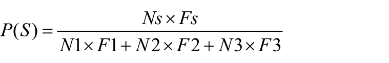
Here, N1 is the number of common millet grains, F1 = 7.5, N2 is the number of foxtail millet grains, F2 = 2.6, N3 is the number of rice grains, N3 = 26, and P(S) is the estimated yield percentage of different crops (Zhou et al., 2016).
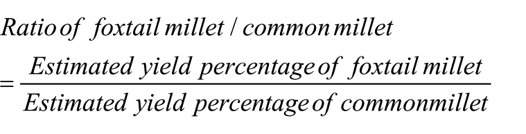
In addition, we used the ratio of estimated yield percentage between the foxtail millet and that of the common millet to elucidate the different crop structure in the millet farming on the north-south Loess Plateau during the late Neolithic. We used the following function:
Results
Identification and radiocarbon dating
In this study, 149 flotation samples of charred seeds were collected from 10 sample sites. The absolute counts of all sample sites are listed clearly (Supplementary Table 1, available online). Of them, 14 taxa had been identified. Two kinds of small-grain millet (P. miliaceum, S. italica) and eight taxa of wild plant, such as Kochia scoparia, Salsola collina, Corispermum sp., Erodium sp., Diarthron sp., Echinochloa sp., and so on, were identified (Figure 2). Some charred seeds were identified only to the level of Family (Supplementary Table 1, available online; Figure 2) and some seeds remained unidentified. Much abundant charred P. miliaceum grains were discovered from F7Z1 (22801 grains) in Dagujie and F7:4 (16850 grains) in Yangjiesha, which are regarded as special contexts. In consideration of their unrepresentative factor, we exclude these flotation samples from further quantitative analysis. Radiocarbon dates of sample sites are listed in Supplementary Table 2 (available online) showing that the sites were used during 3000–2200 cal. BC (Figure 3).
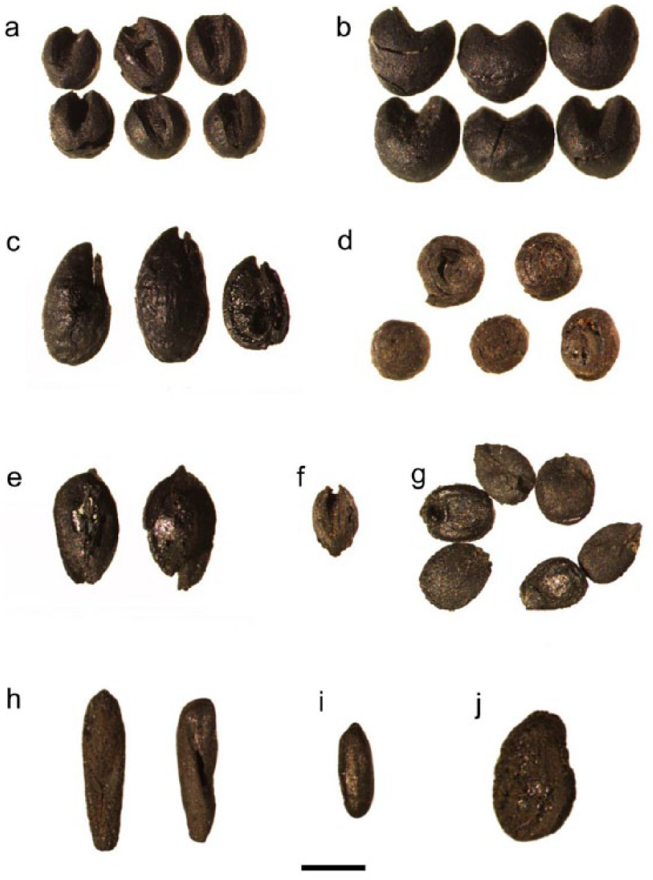
Charred seeds recovered from archaeological sites in Yulin area on the north Loess Plateau. (a) Setaria italica, (b) Panicum miliaceum, (c) Kochia scoparia, (d) Salsola collina, (e) Corispermum sp., (f) Setaria sp., (g) Echinochloa sp., (h) Erodium sp., (i) Poaceae, and (j) Fabaceae (a–g from the Yangjiesha site; h–j from the Dagujie site). Scale bar = 1 mm.
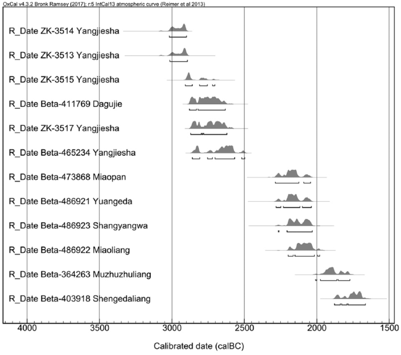
The dates of charred common millet and charcoal as well as animal bone derived by Bayesian statistical modeling for six of the sample sites and two published dating information of archaeological sites on the north Loess Plateau (Chen et al., 2015c; Wu et al., 2016; see Supplementary Table 2 for full details of original data). The horizontal bars below each of the probability density functions reflect the 68.2% and 95.4% highest probability density ranges, respectively.
Quantitative reconstruction of the ancient cropping patterns
Both new and extent macro-botanical data in study sites and their archaeological information are revealed clearly in Supplementary Table 3 (available online). The estimated yield percentages of different crop species are illustrated in Figures 4 and 5. The comparison ratios of foxtail millet/common millet of the LYS-MDG II period and LS period are shown in Figures 6 and 7, respectively.
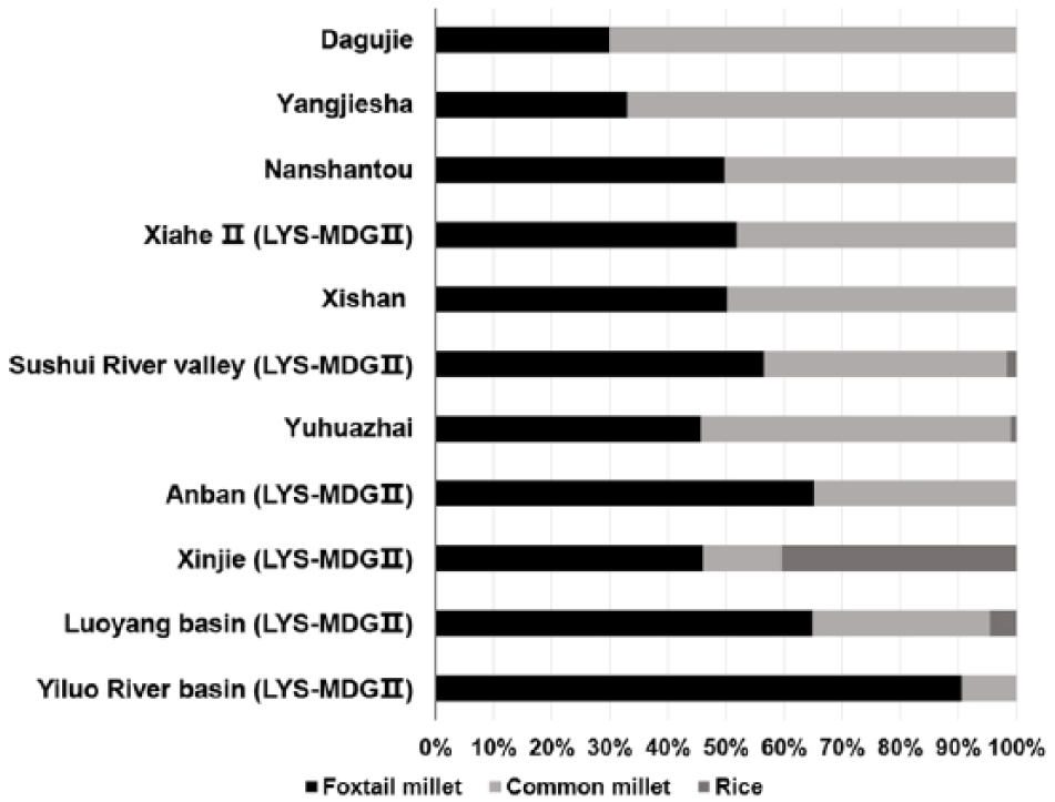
Bar charts showing estimated yield proportions of sites from the north-south Loess Plateau in the LYS-MDG II period (see Supplementary Table 3 for full details of archaeobotanical data from the sample sites and published references).
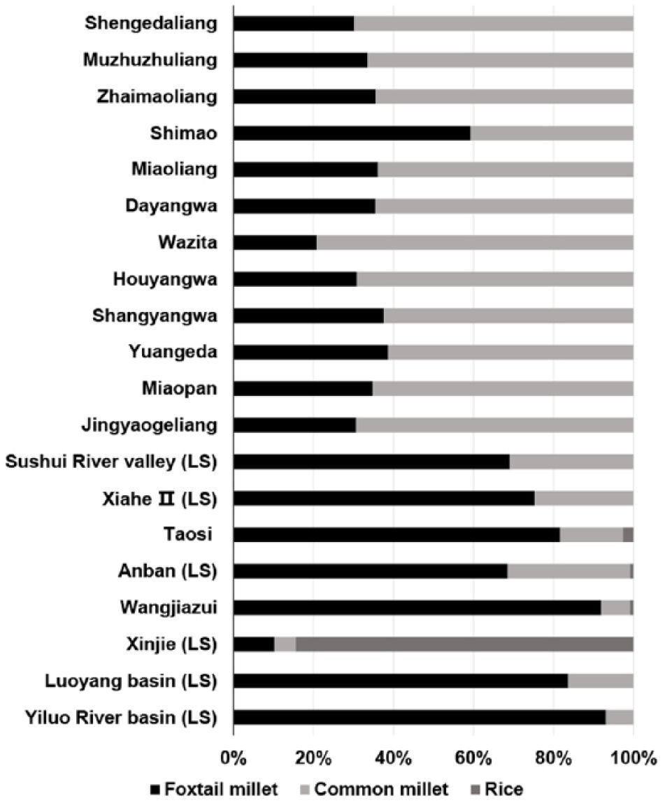
Bar charts showing estimated yield proportions of sites from the north-south Loess Plateau in the LS period (see Supplementary Table 3 for full details of archaeobotanical data from the sample sites and published references).
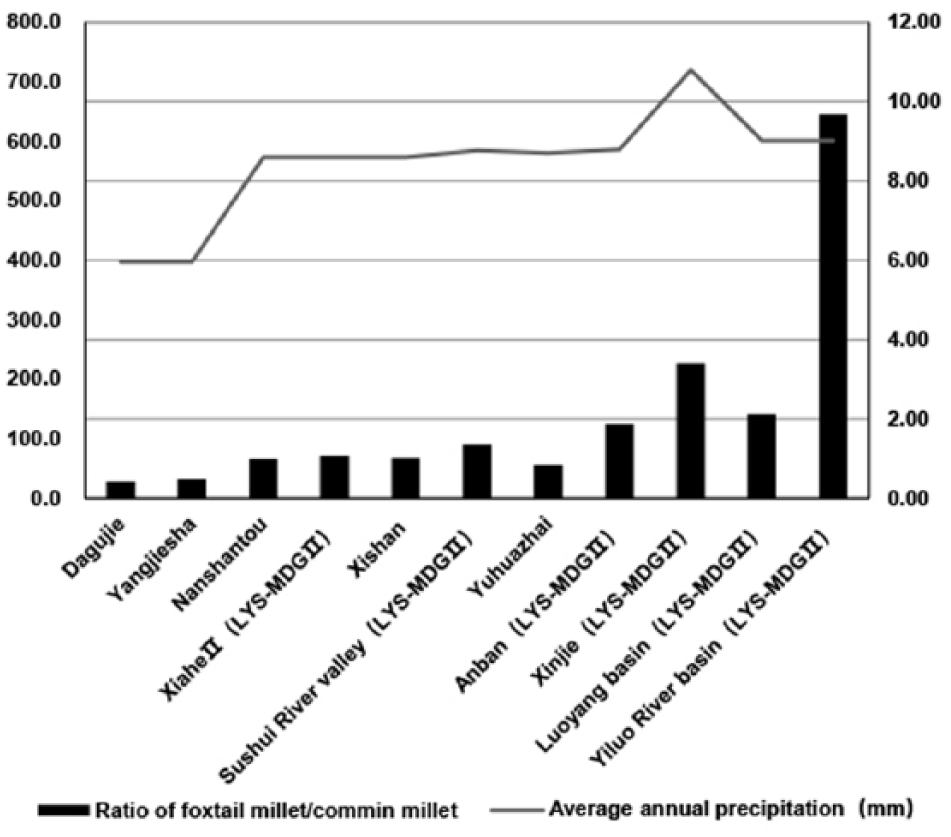
Bar charts of the ratio of foxtail millet to common millet and line charts of average annual precipitation of sites from the north-south Loess Plateau in the LYS-MDG II period (present day annual rainfall is derived from the published reference work of Integrated Scientific Investigation Team to the Loess Plateau, CAS (1992) and the full details of original archaeobotanical data from the sample sites and published references are listed in Supplementary Table 3).
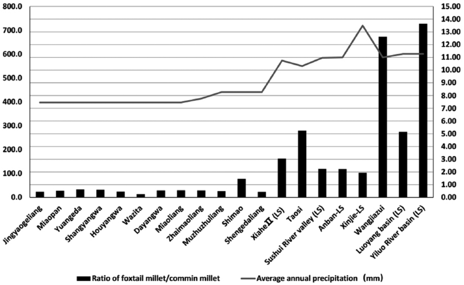
Bar charts of the ratio of foxtail millet to common millet and line charts of average annual precipitation of sites from the north-south Loess Plateau in the LS period (present day annual rainfall is derived from the published reference work of Integrated Scientific Investigation Team to the Loess Plateau, CAS (1992) and the full details of original archaeobotanical data from the sample sites and published references are listed in Supplementary Table 3).
Cropping pattern on the north Loess Plateau
New archaeobotanical data from the sample sites on the NLP of the LYS-MDG II to early LS periods (3000–2200 cal. BC) in this study suggested that two kinds of millet (P. miliaceum and S. italica) dominated in the charred plant assemblages. The estimated yield percentage of common millet at all the sample sites is above 60.0%, whereas the foxtail millet is in a secondary position. In addition, the ratios of foxtail millet/common millet in the sample sites show low values ranging from 0.26 to 0.63 (Supplementary Table 3, available online).
Extant archaeobotanical data also suggested that the common millet dominated in some sites on the NLP during the late LS period (2200–1800 cal. BC), such as Zhaimaoliang, Muzhuzhuliang, and Shengedaliang (Supplementary Table 3, available online). Meanwhile, the ratios of foxtail millet to common millet recovered from the sites mentioned above are still lower than 1.00, ranging from 0.43 to 0.50, showing that the common millet is probably more in the ancient crop production on the NLP compared with foxtail millet (Figure 7). In addition, the common millet of Zhaimaoliang comprises 64.5% of the estimated yield percentage; similarly, at Muzhuzhuliang and Shengedaliang, it comprised 66.5% and 69.8%, respectively (Figure 5).
However, macro-botanical records at the Shimao site showed a distinct situation compared with other contemporary sites on the NLP. Specifically, the ratio of foxtail/common millet suddenly increased to a high level, with a value of 1.45 (Figure 7; Supplementary Table 3, available online); the estimated yield percentage of common millet only occupied 40.8% (Figure 5), whereas foxtail millet dominated in charred crop macrofossils, suggesting that there is probably a marked increase in foxtail millet production at Shimao compared with other contemporary human societies on the NLP during the late LS period (2200–1800 cal. BC).
Cropping pattern on the middle Loess Plateau
We re-analyzed the extant archaeobotanical data recovered from the MLP where it is mostly in the inner center part of the eastern Loess Plateau. Plant macrofossils were mainly unearthed from the Baishui River valley in the Shaanxi province which belongs to a branch of the North Luo River and the Sushui River valley in the Shanxi province on the middle reaches of the Yellow River basin. It is indicative that the cropping patterns on the MLP during the late Neolithic period (3500–1800 cal. BC) revealed relatively high values (0.99–1.36) in the comparison ratios of foxtail millet to common millet compared with those ratios recovered from the NLP. Apart from that, nearly fair or considerable amounts of estimated yield proportion of foxtail millet (49.7%–56.6%) compared with common millet showed that the foxtail millet is widely expanded and cultivated in the Baishui River and Sushui River valleys compared with contemporaneous archaeobotanical sites on the NLP.
In addition, based on published macro-botanical data, there was no rice cultivation in the Baishui River valley in the LYS-MDG II period dating around 3500–2500 cal. BC (Supplementary Table 3, available online; Figure 4). However, 5 charred rice (O. sativa) grains were recovered from the cultural layers of the LYS-MDG II period in the Sushui River valley which occupied 1.7% of the estimated yield percentage, and the charred remains of the LS period (2500–1800 cal. BC) at the Taosi site situated in the Fen River basin were 30 grains and the yield percentage was only 2.7% (Supplementary Table 3, available online; Figure 5). At the same time, foxtail millet cultivation had become more extensive at Taosi, Xiahe II, and Sushui River valley, occupying about 81.7%, 75.3%, and 69.1% of the yield percentage during 2500–1800 cal. BC (Figure 5). It also showed very high values of the comparison ratio of foxtail/common millets, ranging from 2.24 to 5.24 in this area (Wang, 2014; Zhao and He, 2006) (Figure 7).
Cropping pattern on the south Loess Plateau
The ‘first’ crop pattern which is revealed by relatively high values of the ratio of foxtail millet to common millet, as well as the large proportion of foxtail millet, was likely common on the SLP during the LYS-MDG II period (3500–2500 cal. BC; Supplementary Table 3, available online). It showed high foxtail millet/common millet ratio in the Anban site, Luoyang basin, and Yiluo River basin, ranging from 1.87 to 9.69, and a large estimated yield proportion of foxtail millet (64.9%–90.6%) (Figure 5). During the LS period (2500–1800 BC), foxtail millet still occupied large percentage with high value of the comparison ratio to common millet in the Anban site, above survey areas and the Wangjiazui site (Figure 7). In addition, rice cultivation had already imported to Anban and Wangjiazui in the LS period, yet only occupied a small proportion under 1.0% (Figure 5).
The ‘second’ cropping pattern was probably in the southeast part of the Wei River basin showing that local farmers mixed the millet and rice cultivation in the agricultural production during the late Neolithic. For example, at the Xinjie site, foxtail millet had high comparison ratio (3.40); however, it showed relatively low proportion (46.1%) in estimated yield percentage in the LYS-MDG II period (3500~2500 cal. BC) compared with the data at the Anban site, Luoyang basin, and Yiluo River basin (Figure 4). Besides, the rice comprised 40.4% of the production percentage at Xinjie during the LYS-MDG II period (Figure 4). Later, the estimated yield proportion of rice at Xinjie showed a considerable increase from 40.4% to 84.5% in the LS period (2500–1800 cal. BC) (Figure 5).
The ‘third’ cropping pattern was likely accepted by ancient farmers at the Yuhuazhai site which is located in Xi’an city. In this study, foxtail millet comprised about 46.1% of the estimated yield percentage, yet that value of the common millet is beyond 50.0% in Yuhuazhai during 3500–3000 cal. BC (Figure 4). And the ratio of the foxtail millet and common millet revealed relative low value (0.85) compared with other archaeological sites on the south Loess Plateau so far (Figure 6). In addition, doubtful rice farming probably accounted for a very low proportion of agricultural production in the Yuhuazhai site after only one grain of charred rice was recovered from the floatation samples.
Discussion
Millet farming on the north Loess Plateau during 3000–2200 cal. BC
In this study, our new archaeobotanical data from the 10 sample sites fill in a critical gap in the macro-botanical research of the ancient cropping patterns in Yulin area on the NLP during 3000–2200 cal. BC and highlight the long history of millet cultivation and consumption in northern China as well (Barton et al., 2009; Dong et al., 2016; Zhao, 2011; Wang et al., 2014, 2017). The past C4 isotopic signatures of human and domesticated animals around 3000–1800 cal. BC from the NLP were interpreted as consuming substantial amounts of millet foods (Atahan et al., 2014; Chen et al., 2015c, 2017; Guan et al., 2008). The new archaeobotanical findings at Dagujie and Yangjiesha provided the earliest direct macrofossil records of the millet agricultural landscape on the NLP during 2900–2500 cal. BC so far. In addition, other eight sample sites of the early LS period (2500–2200 cal. BC) on the NLP gave the first uncovering macro-botanical evidence of the millet agriculture in Yulin area during that period.
Compared with our new macro-botanical evidence with extant charred cereal data of the late LS period (2200–1800 cal. BC) on the NLP, such as Zhaimaoliang, Muzhuzhuliang, and Shengedaliang, it is indicative that the common millet continues to dominate the crop structure in Yulin area from about 3000 to 1800 cal. BC. Moreover, the analysis of phytoliths from profiles and pits at two archaeological sites in Yulin area during LYS-MDG II and LS periods revealed that the common millet is also superior to foxtail millet (Xia, 2015; Xia et al., 2016). On the contrary, in the comparison of crop structures between the north Loess Plateau during the LYS-MDG II to LS periods and the contemporary sites on the middle and south Loess Plateau (Figures 4–7), it is shown that foxtail millet becomes more dominant than common millet in the cropping pattern of prehistoric agricultural economy in the southern Loess Plateau. For that matter, we have a good reason to consider that the extensive common millet–based farming is widely accepted in the dryland agriculture in the northern corner of central Loess Plateau during the late Neolithic period.
Based on the extant macro-botanical evidence, it is displayed that the southern areas include the MLP and SLP and have relative diverse cropping patterns from the LYS-MDG II to LS periods. For example, there were at least three kinds of cropping patterns in the Wei River basin during 3500–1800 cal. BC. In the western part of the Wei River basin, Anban site and Wangjiazui site, it is shown that foxtail millet was dominant in the cropping pattern; even very small amount of rice farming is likely accepted by ancients in the LS period (Figures 4 and 5). In the southeast part of the Wei River basin, such as Xinjie site, it is revealed that foxtail millet and rice agriculture were nearly of the same proportion during the LYS-MDG II period. Furthermore, rice farming likely becomes dominant in the millet–rice mixed agriculture at Xinjie during the LS period. Relatively special, the common millet got a considerable position in the crop structure at Yuhuazhai at about 3500–3000 cal. BC on the central part of the Wei River basin (Figure 4). As for the ancient farmers on the MLP such as Baishui River valley, Sushui River valley, and Fen River basin, foxtail millet farming become more extensive from the LYS-MDG II to LS periods. The rice farming landscape was likely mapped on the eastern part of the MLP at 3000–2500 cal. BC, but it still had a slow pace in expansion.
Different crop arrangement in adaptation to water stress
North China has long been accepted as one of the independent original centers for millet agricultural food production (Zhao, 2011). In the past decades, a relatively large number of archaeobotanical records have been recovered from the archeological sites such as Dadiwan (Liu et al., 2004), Cishan (Lu et al., 2009), and Xinglonggou (Zhao, 2011), which showed that the common millet (P. miliaceum) is the principal cereal dominant in agricultural production during the early Holocene. Yet, since the strong impact of the summer monsoonal climate in East Asia during the Holocene Optimum (Lu and Guo, 2015), foxtail millet (S. italica) greatly increased along with the warming and wetting environmental conditions during the Holocene Optimum and had become the most important cereal which is extensively cultivated in the middle Yellow River basin by the late Neolithic period (6000–4000 cal. BP) (Dong et al., 2016; Li et al., 2003; Zhou et al., 2011). In addition, with the import of rice (O. sativa) cultivation in that relative warm-humid period, the mixed millet–rice farming was configured in the Wei River basin on the SLP (He et al., 2017).
Foxtail millet (S. italica) and common millet (P. miliaceum) often served as essential crop portfolio by agrarian communities, which were widely cultivated on the Loess Plateau for countless millennia (Weber and Fuller, 2008; Zhang et al., 2007). Both millets have similar life circle and overlapped distribution (http://www.cgris.net/cgris_english.html), yet they still have some bioclimatic and physical differences (Hattersley, 1982; Hu et al., 2002). The foxtail millet is a kind of relatively small drought-tolerant warm season cereal. It is well suited to a wide range of soils under dry conditions and completes its growth cycle (Zohary et al., 2012). However, common millet is a kind of hardiest cereal with relatively stronger drought and saline-alkaline resistance than foxtail millet (Northwest A&F University, 1991). It has stronger resistance to disease and a very short growth time (nearly 60–90 days), widely cultivated in northern China. In contrast to drought-tolerant millets, rice (O. sativa), which is an indigenous crop cultivated in warm-wet areas of southern China, have very different life cycles and ecological niches, which implies that it needs more water resources and infield management in the growth time (He et al., 2017).
Previous research works of pollen and charcoal records on the loess deposits showed that the north-south Loess Plateau had a strong climatic gradient during the Holocene (Cheng and Jiang, 2011; Li et al., 2009; Shang and Li, 2010; Sun et al., 2014). It is plausible to believe that the ancient cropping patterns are probably influenced by variable water stress on the Loess Plateau. In this study, millet-based farming dominated on the MLP and SLP during the late Neolithic (3500–1800 cal. BC). However, the common millet occupied a large percentage in the estimated yield of crops at 13 (93%) archeological sites on the NLP from the LYS-MDG II to LS periods (3000–1800 cal. BC) (Figure 5). In addition, common millet at Yuhuazhai on the SLP also shows large percentage in the crop structure during the LYS-MDG II period. In these cases, we can infer that ancient farmers from the southern to northern part of the eastern Loess Plateau during 3500–1800 cal. BC had distinct zonal cropping patterns under different water conditions (Figures 6 and 7). Furthermore, inhabitant of the SLP probably had more choice or freedom in crop management.
The climatic conditions on the SLP during the mid-late Holocene with enough water resources might have created available environment for a mixed crop production consisting of abundant millet and some rice farming (Figure 5) (He et al., 2017; Liu, 2014; Zhang et al., 2011; Zhong et al., 2015). Besides, the MLP had semi-arid climate which likely provides basic water resources for foxtail millet farming during 3500–1800 cal. BC and small amount of rice cultivation on the Sushui River valley and Fen River basin during LYS-MDG II to LS periods (Figure 5). However, the NLP is adjacent to the Mu Us Desert with temperate-arid climatic and poor soil conditions (Jin et al., 2001; Su et al., 1999). Its geomorphic landscape is usually characterized by gullies and wind-sand grass shoal (Institute of Hydrogeology and Engineering Geology, CAGS, 1986). The dominance of common millet cultivation configuring in the landscape on the NLP during late Neolithic (3000–1800 cal. BC) might have occurred in response to arid environment which is highly sensitive to climatic fluctuation during the mid-late Holocene (Figures 5–7) Cheng et al., 2011; Jiang et al., 2013; Li et al., 2003, 2000; Wanner et al., 2008).
In our study, the zonal patterns in the ancient agricultural practices on the north-south Loess Plateau demonstrated agricultural adaptation to different water stress – from intensively foxtail millet–based cultivation in the relative humid south to more extensively common millet farming in the arid north (Figures 6 and 7). From the archaeological perspective, it is shown that the most agrarian communities continue the previous cropping patterns which are shaped since the beginning of the LYS-MDG II period, yet there was an increase in foxtail millet cultivation and relative diverse choice in the cropping patterns on the MLP and SLP, respectively, under colder and dryer climatic conditions during the LS period (Chen et al., 2015b; Marcott et al., 2013) (Figures 4 and 5). Therefore, it is reasonable to believe that the selection of suitable agricultural productions and cropping patterns by early farmers who take account of ecological knowhow in the long-term human–environment interactions provide basis to different trajectories of agricultural developments from the northern to southern part of the eastern Loess Plateau during 3500–1800 cal. BC.
How to feed the early urbanized center on the north Loess Plateau
According to accumulating archaeological records in the past decade, Shimao site, which has the biggest stone fortification in northern China, was the most developed complex urbanized center with high population densities on the NLP during 2200–1800 cal. BC (Sun, 2016; Sun et al., 2013). Especially, most of the archaeological findings showed that Shimao was hierarchically organized, and its political control, ritual power, and material wealth were probably related and concentrated in small groups of elites (Sun and Shao, 2016; Sun et al., 2017). In this study, extant archaeobotanical findings at the relatively small settlements on the NLP from 2200 to 1800 cal. BC (Figures 5–7), such as Zhaimaoliang, Muzhuzhuliang, Shengedaliang, indicated that the cropping patterns at these sites are relatively consistent with those of the previous crop arrangement from as early as around 3000 cal. BC on the NLP. Common millet occupied a large percentage of the estimated crop yield showing low values of foxtail/common millet ratio as well, which suggested that such arid-oriented millet management is likely to be a deliberate means of ensuring adequate cereal production by early crop producers and playing a key role in the household-level millet cultivation on the NLP in the late Neolithic.
However, there was a distinct cropping pattern at Shimao which is contrary to the dominant models of earlier cropping pattern on the NLP since about 3000 cal. BC. It appeared as high percentage of foxtail millet in the yield and relative high ratio of foxtail/common millet at Shimao (Figures 5 and 7). Extant agricultural reports suggested that the foxtail millet in the context of suitable water status and plenty of labor could produce more than twice the production of common millet on the Loess Plateau (Chai and Feng, 2003). In consideration of that, we argued that the intensive foxtail millet farming, which is likely achieved by expanding the absolute scale of cultivation, is likely attributed to population or food pressure and intensification of agricultural activities in the Shimao site (Sun et al., 2017). In addition, previous archaeological evidence also suggested that political control, ritual power, and material wealth are likely concentrated at the elites at Shimao during the late LS period (Sun, 2016; Sun et al., 2017). It is plausible to believe that relatively large amounts of foxtail millet at Shimao are likely related to elite-controlled cereal redistribution (Styring et al., 2017) and/or the trade with other agarin communities further in southern areas on the Loess Plateau.
As for the rise of Shimao, there are many heated discussions and different opinions from interdisciplinary evidence (Chen et al., 2017; Hu et al., 2016; Sun, 2016; Wang and Guo, 2016). Faunal remains recovered from Shimao (Hu et al., 2016; Sheng et al., 2017) and Muzhuzhuliang (Guo, 2017) suggested that the introduction and utilization of sheep (Ovis aries, Capra hircus) and cattle (Bos taurus) promoted by trans-Eurasia culture exchange in the second half of the third millennium BC might play even more important role in economy on NLP during the LS period. The same circumstances can also be detected in contemporaneous Taosi site on the MLP (Bo, 2011). However, based on stable isotope analysis of human and domesticated animal bones at Shimao (Cai, 2015), Muzhuzhuliang (Chen et al., 2015c), and Shengedaliang (Chen et al., 2017), it is indicated that ancient humans and their livestock consumed large amount of millet-based foods, and the meat contributes less to human dietary (Chen et al., 2015c). In this connection, we argue that millet farming is the cornerstone of agricultural economy on the NLP during 3000–1800 cal. BC, yet sheep/cattle husbandry is the most active element in economy on the NLP during the LS period. The results of our study shed light on that the extensive common millet–based farming configures around the low-level settlements and the increased foxtail millet cultivation or possession exists in the high-level urbanized center, namely, Shimao site, on the NLP from third to second millennium BC and likely provided the archeological evidence of binary patterns of regional urban and rural crop management in north China.
Conclusion
The Loess Plateau has a clear monsoonal climatic gradient in the Holocene, especially from the northern to the southern regions. It produced distinct water stress levels causing the difference in natural vegetation, and circumstance often served as the most important environmental factor shaping different prehistoric agricultural systems. New archaeobotanical evidence is indicative that foxtail millet (S. italica) dominated in the crop pattern in the semi-humid south and semi-arid middle parts of the Loess Plateau ranging from 3500 to 1800 cal. BC. The macrofossil recovered from 13 archeological sites on the NLP showed that ancient farmers in such arid area were engaged in extensive common millet (P. miliaceum)–based farming from third to second millennium BC, while the ancient Shimao people controlled more foxtail millet foods to support early urbanized population center during 2200–1800 cal. BC. Our results of this study also suggested appropriate agricultural activities and crop patterns selected by ancient farmers to adapt to different water stress that probably promoted different human societies and turned on diverse developmental ways of ancient civilizations on north-south part of the eastern Loess Plateau.
Supplemental Material
HOL782610Supplementary_Table – Supplemental material for North-south patterning of millet agriculture on the Loess Plateau: Late Neolithic adaptations to water stress, NW China
Supplemental material, HOL782610Supplementary_Table for North-south patterning of millet agriculture on the Loess Plateau: Late Neolithic adaptations to water stress, NW China by Pengfei Sheng, Xue Shang, Zhouyong Sun, Liping Yang, Xiaoning Guo and Martin K Jones in The Holocene
Footnotes
References
Supplementary Material
Please find the following supplemental material available below.
For Open Access articles published under a Creative Commons License, all supplemental material carries the same license as the article it is associated with.
For non-Open Access articles published, all supplemental material carries a non-exclusive license, and permission requests for re-use of supplemental material or any part of supplemental material shall be sent directly to the copyright owner as specified in the copyright notice associated with the article.