
Abstract
Archaeobotany is used to discover details on local land uses in prehistoric settlements developed during the middle and beginning of late Holocene. Six archaeological sites from four countries (Spain, Italy, Greece, and Turkey) have pollen and charcoal records showing clear signs of the agrarian systems that had developed in the Mediterranean basin during different cultural phases, from pre-Neolithic to Recent Bronze Age. A selected list of pollen taxa and sums, including cultivated trees, other woody species, crops and annual or perennial synanthropic plants are analysed for land use reconstructions. In general, cultivation has a lower image in palynology than forestry, and past land uses became visible when oakwoods were affected by human activities. On-site palynology allows us to recognise the first influence of humans even before it can be recognised in off-site sequences, and off-site sequences can allow us to determine the area of influence of a site. Neolithic and Bronze Age archaeological sites show similar land use dynamics implying oak exploitation, causing local deforestation, and cultivation of cereal fields in the area or around the site. Although a substantial difference makes the Neolithic influence quite distant from the Bronze Age impact, mixed systems of land exploitation emerged everywhere. Multiple land use activities exist (multifunctional landscapes) at the same time within the area of influence of a site. Since the Neolithic, people have adopted a diffuse pattern of land use involving a combination of diverse activities, using trees–crops–domesticated animals. The most recurrent combination included wood exploitation, field cultivation and animal breeding. The lesson from the past is that the multifunctional land use, combining sylvo-pastoral and crop farming mixed systems, has been widely adopted for millennia, being more sustainable than the monoculture and a promising way to develop our economy.
Introduction
According to Food and Agriculture Organization/United Nations Environmental Programme (FAO/UNEP; 1999) and the Intergovernmental Panel on Climate Change (IPCC, 2000) Special Report on Land Use, Land-Use Change and Forestry, land use is ‘the total of arrangements, activities, and inputs that people undertake in a certain land cover type’. Land use is thus a concept that depends on both plant cover (Nature) and human activities (Culture). The availability of natural resources relies on ecological and phytogeographical diversity. At different latitudes, species distributions are controlled by moisture availability, nutrient supply and light exposure. Each environment has distinct geomorphological characteristics and soil types which can influence land cover. Each of these features allows, or may trigger, a certain type of land use. As in the suggestive title Fields of Change edited by Cappers (2005), it is evident that our (cultural–agrarian) land uses have been, and still are, subjected to transformations under environmental-climatic as well as socio-economic changes. Several categories of land use are identified by the IPPC report that point to an Increasing Intensity of Use (IIU): from deserts, non-forest wooded lands or wetlands to forestry, land under shifting cultivation, temporary fallow, permanent pastures, permanent or temporary crops and the modern (residential/industrial/transportation) facilities.
In the past, and even today, our behaviour must have been determined by the primary needs of our species (sensu Maslow, 1943) including water, food, clothing and shelter. Plants have been especially responsible for the development and success of different land-use strategies, from hunting and gathering to crop cultivation to farming and forestry, to the management and shaping of landscapes. From an ecological approach (Faegri et al., 1989), the direct and indirect consequences of human activities on the environment are expected to drive changes in vegetation cover on a long-term perspective. Mercuri et al. (2010: 861) observed that land uses might have low influence or high impact depending on the scale (space) and duration (time) of the human presence/action in a given territory; this produces different effects on the environment. As a result, this human influence or impact on plant cover may be variable and not always detectable over a large area, far from settlements or productive areas.
Succession from simple to complex forms of land exploitation, local and regional differences, and intensity of use are often obtained by the comparison between on-site and off-site pollen records. The terms have a general meaning of ‘local’ or ‘regional’ study, respectively, but their use may have different nuances in different cases. The degree of understanding of the ecological, formal and cognitive levels of cultural landscapes depends on the chronology and contexts (Mercuri, 2014). Classically, the synanthropic and cultural plants from archaeological sites (on-site) provide local signals of the human role in past vegetation history (Mercuri and Sadori, 2014; Sabato et al., 2015), with intermediate contexts (Mercuri et al., 2002; Pepe et al., 2013), while off-site palynology is used as a measure of this role over large areas (Colombaroli et al., 2008; Jahns, 1993, 2005; Marinova et al., 2012; Revelles et al., 2018; Vannière et al., 2008; Vescovi et al., 2010; Weiberg et al., 2016).
Human action is evident from archaeology, and human-induced changes in flora composition and vegetation cover should have occurred earlier near settlements and in the places that today we call ‘archaeological sites’, and then spread to the surrounding area leaving increasingly visible traces in sedimentary archives (Mercuri et al., 2012). Hence, the study of land uses may be notably improved by archaeopalynology: the analysis of pollen from archaeological sites (Dimbleby, 1985; Faegri et al., 1989). From the one-site to one-area approach, if the interdisciplinary study of one archaeological site shows local space–time events and the behaviour of a few people, the integration of data from many sites enables regional and cross-cultural landscape reconstructions (Mercuri, 2008; see also the multi-point and multi-site sampling concepts of palynology in Mercuri et al., 2015c: 237; on pollen sampling strategy, see also Figure 2 in Mercuri, 2014).
It is often assumed that there are many taphonomical problems associated with on-site palynology, both in terms of pollen transport and post-depositional decay. In some archaeological layers, the poor state of preservation of pollen grains, especially due to oxidation or the local use of fire, discourages analysts to carry out such analyses. However, the palynology of archaeological sites has been utilised for many decades and can be considered as an important part of archaeobotany (e.g. Mercuri et al., 2015a). Today, it is clear that the correct sampling strategy, well-studied stratigraphy and chronology, and interdisciplinary interpretation are basic to obtain robust data from these special archaeo-environmental contexts.
Pollen as ‘land-use’ evidence
Starting from general knowledge on botany and ecology, pollen taxa are commonly grouped into sums useful for environmental and land-use reconstructions. The Anthropogenic Pollen Indicators (API) are a substantial, intrinsic part of past pollen diagrams in the Mediterranean area because people generated impressive patterns of landscape complexity, and the flora/vegetation has pervasively been transformed by cultural waves during the Holocene (Mercuri et al., 2011; Roberts et al., 2011; Zohary and Hopf, 2000). The main sums for environmental reconstructions are the arboreal or woody plant (upland forest, mixed deciduous forest, Mediterranean forest or shrubland and macchia), and the wetland plants (riverine wood and hydro-hygrophilous herbs) (for a review of sums, see Kouli et al., 2018). The sum of steppic indicators showing open landscapes, dominated by grasses and steppe elements (non-arboreal pollen [NAP]) is quite ambiguous, as most taxa can be regarded as composed of wild steppe and grassland vegetation types or wild synanthropic, that is, anthropogenic, species (Mercuri et al., 2013a). For example, the presence of steppe indicators (Artemisia, Chenopodiaceae, Apiaceae) during the Younger Dryas cool oscillation, despite the recovery of many settlements in the Italian peninsula (Mussi and Peresani, 2011), may reasonably be regarded as evidence of natural vegetation favoured by both the climate and presence of large herds of herbivores needing and maintaining open grasslands until the Pleistocene/Holocene transition (Burney and Flannery, 2005). Similarly, the arboreal pollen (AP) curve can be a result of climate (e.g. Sadori et al., 2016) or human action in the case of trees exploitation to wood management (Mercuri and Sadori, 2014; see, for example, the wood management of the Terramare culture: Mercuri et al., 2006b, 2015a). However, unlike off-site records, trends in wild anthropogenic taxa and the AP pollen sum from archaeological sites can be used as unambiguous indicators of human actions (Mercuri et al., 2013a: 150).
The main sums for land-use reconstructions are the cultivated plants (trees and other woody species, and annual or perennial herbs) and the synanthropic plants. Weeds and ruderals growing within farming contexts and open disturbed ground are the main contingent of synanthropic plants (secondary anthropogenic indicators sensu Behre, 1990).
Altogether, pollen from cultivated and synanthropic species form the sum of API associated with human activities (Behre, 1981; López-Sáez et al., 2006; see Mercuri et al., 2013a for ubiquitous pollen taxa in archaeological sites of Italy).
The OJC group, including Olea, Juglans and Castanea pollen, is an important marker of increasing anthropization in the Mediterranean area (Florenzano et al., 2017; Mercuri et al., 2013b) being sometimes constituted by the three curves (as in central Italy: Mercuri et al., 2002; Stoddart et al., this issue) or coinciding with only one or two of these tree pollen. Other woody plants, such as Vitis and Corylus, when cultivated, may be important cultural markers while the woody plants collected in the wild may be significant even if rare (e.g. Cornus, Prunus and Rubus).
Cereals (cerealia-type; primary anthropogenic indicators sensu Behre, 1990) are considered among the clearest signal of agrarian land use. As many cereals are low pollen producers, they indicate crop fields and agricultural systems in a site/region even if under-represented in pollen spectra. Other sums are more focused on reconstructing pastoral and breeding activities. The Local Pastoral Pollen Indicators (LPPI) and Regional Human Activities Pollen Indicators (RHAPI) are indices that are used to infer local pastoral activities and background human activities, respectively (Mazier et al., 2009). The Pollen Disturbance Index (PDI) includes selected pollen taxa that have been correlated with pastoral activities in the Hellenic peninsula (e.g. some Sarcopoterium, Plantago and Polygonum species; Bottema, 1982; Bottema and Woldring, 1990; Kouli, 2012, 2015). Field observations on the current distribution of Cichorieae have demonstrated that, although the cichory tribe is common in many habitats of southern Italy, its abundance increases in open habitats including pastures, and the smallest size pollen belongs to species typical of secondary pastures (Florenzano et al., 2015). High percentages of this pollen in the spectra can thus be regarded as a good indicator of grasslands used for pasture in land-use reconstructions. Increases in other API taxa can reflect enhanced trampling (Plantago), excrement deposition (Urtica), field weeds (Aphanes), fodder and breeding/pastoral practices (Fabaceae, Asteroideae).
Aim of this article
The aim of the article is to show how the API may fruitfully be used to obtain detailed reconstructions on the local land-use types. Prehistoric sites have been selected that cover phases of the mid and late Holocene (c. 8000–2800 yr cal. BP), the period that saw the rise and fall of cultures from pre-Neolithic to Neolithic, Chalcolithic up to the Middle and Recent Bronze Ages in the Mediterranean. The Neolithic to Bronze Ages saw the passage from the adoption of agriculture to advanced farming cultures. New relationships between human societies and environment were accompanied by profound changes. The ability to cultivate domesticate species gave to the early farmers an increase of control on natural events, a new opportunity they obtained also by means of a different type of knowledge on plants (Mercuri and Sadori, 2014: see the table at p. 508).
Archaeobotany has great potentiality for environmental and palaeoethnobotanical purposes, with samples collected from almost every type of archaeological item/context (Cappers and Neef, 2012; Kouli and Dermitzakis, 2003; Mercuri et al., 2015a; Pearsall, 2016; Riera et al., 2018). In this synthesis, we focus on data from palynology and vertical sampling. Vertical sampling provides a biostratigraphical analysis and allows changes in plant assemblages to be identified across long-term sequences. This gives the opportunity to reconstruct land transformations in a diachronical palaeoecological perspective. Horizontal sampling (not fully considered here) uses many samples/points from one chronological phase or archaeological site and is more helpful to understand intra-site patterns in plant uses such as processing or storage (e.g. Van der Veen, 2007 for macroremains; Rattighieri et al., 2013 for pollen).
In this article, the pollen data from archaeological sites represent different types of Intensity of Use across four countries within the Mediterranean Basin (Spain, Italy, Greece and Turkey; Figure 1). Where pollen preservation is poor and thus low numbers of pollen samples are available (as in Closos de ca’n Gaià and Arslantepe), anthracological data are added to aid interpretation (Sadori et al., 2010). The sites were settled in very different environmental contexts, from the shore of Lake Banyoles in NE Iberia (La Draga) to the western Mediterranean Balearic Islands (Closos de ca’n Gaià), to the alluvial plain of North Italy (terramaras of Montale and Santa Rosa di Poviglio), and to the shore of Lake Orestias or Kastoria (Dispiliò) and the tableland of eastern Anatolia (Arslantepe) in the eastern Mediterranean. In this synthesis, the archaeological sites have been considered for their common features that allow general to detailed archaeo-environmental descriptions, the reconstruction of land uses in the Mediterranean basin and the general comparison with off-site pollen data over five millennia.
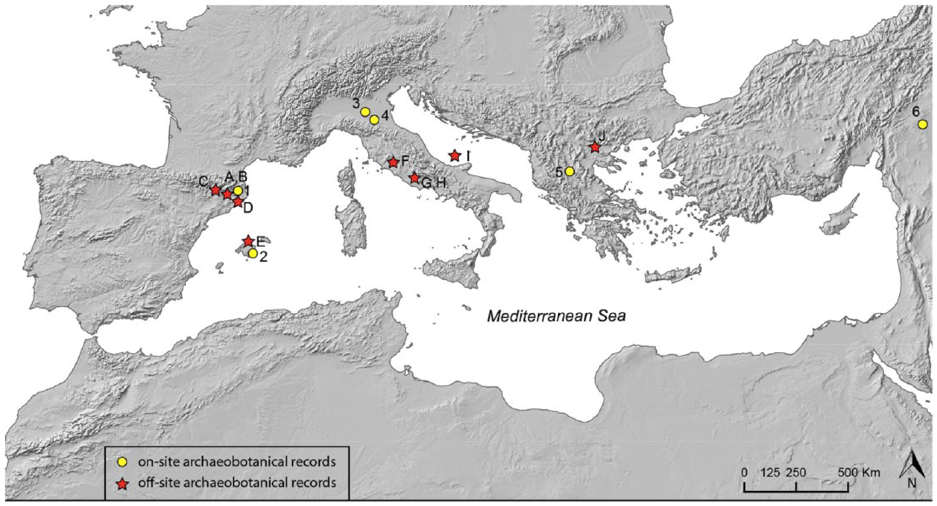
Location map showing the sites reported in this article including six archaeological sites: (1) La Draga, (2) Closos de ca’n Gaià, (3) Poviglio, (4) Montale, (5) Dispiliò and (6) Arslantepe, and 10 off-/near-sites: (A) Lake Banyoles, (B) SB2 Banyoles, (C) Les Palanques, (D) Sobrestany, (E) S’Albufera d’Alcúdia, (F) Lake Mezzano, (G) Lake Nemi, (H) Lake Albano, (I) RF93-30 and (J) Lake Dojran.
Methods
Six prehistoric settlements from four countries facing to the Mediterranean basin have been selected to present archaeobotanical data from archaeological sites (Table 1). The sites located in Italy are part of the database BRAIN, and the others have been now added in the special section of ‘Extra-Italy’ records (brainplants.successoterra.net). The settlements preserved pollen and macrobotanical remains and have been studied within interdisciplinary archaeological research programmes. Most of the archaeobotanical study was carried out on samples taken during archaeological fieldwork: pollen samples were collected from stratigraphic sequences/trenches or cores, distinguishing between on-site (from the settlement excavation) and near-site (just next to the site but known to be in the site’s area of influence, the territory visited every day by the inhabitants). Samples for macrobotanical remains were taken from occupation layers discovered during the excavations. A charcoal sample includes all the wood fragments corresponding to one single wood, or those recovered from the fill of small features or single structure (Masi et al., 2018).
List of the archaeological sites reported as case studies in this article.
VP: Villaggio Piccolo; VG: Villaggio Grande.
Pollen taxa and sums from 13 sequences/trenches/cores, have been drawn with Tilia diagrams (Grimm, 2015) plotted against samples or chronology. The list of taxa includes the main elements of natural land cover (Pinus, Abies, Quercus, Corylus, Alnus; Poaceae), and the known anthropogenic taxa. The latter include woody plants as OJC, and possibly Vitis although it has different reproductive features, and therefore different pollen production, in wild and domesticated subspecies. Anthropogenic taxa also include herbaceous plants such as cereals, Cichorieae, Artemisia, Centaurea, Plantago, Trifolium type, Urtica. Pollen sums were calculated for mixed oakwoods, sclerophyllous vegetation, shrubland, grassland, wetland, and weeds/anthropogenic environments.
Samples were grouped into 90 time slots from c. 8000 to 2800 cal yr. BP to compare the trends of the main pollen taxa and sums. The time slots are contiguous but not of equal duration. Time slots were established on the basis of radiocarbon dates, stratigraphy-sedimentation rate and cultural attributions of the layers of each site. Each sample was attributed to one time slot, and each time slot includes samples with a similar age from different sites. Harmonising the pollen data into time slots was necessary as the pollen sequences had variable temporal resolution (from c. 9 to 200 years), depending on the archaeological deposits, with the highest resolution observed in the Terramara’s Bronze Age stratigraphies (9–12 years).
Pollen data were ordinated by Principal Component Analysis (using XLSTAT). The PCA uses the percentage values of taxa that are included in the groups described above and was performed using the sampling points as variables. Pollen data were ordinated by Principal Component Analysis (using XLSTAT). The PCA uses the percentage values of taxa and was performed using the sampling points as variables. The percentage calculations are made in terms of percentages of the total pollen sum (including all pollen types) for the taxa grouped into main sums useful for landscape reconstructions described above. The data set analysed is composed of 226 pollen spectra.
The case studies
The data sets selected for this synthesis show evidence of land uses, including changes in arboreal taxa (Figure 2), and diachronic evolution of cultural landscape along about 5000 years of human activities crossing different cultural periods. From the West to East, the sites include La Draga and Closos de ca’n Gaià from Spain, the terramaras of Montale and Santa Rosa di Poviglio from Italy, Dispiliò in Greece and Arslantepe in Turkey. Below, after a short description of the archaeological deposits and the main results from pollen collected from both on-site and near-site layers, general trends in land uses in the different Mediterranean regions are reported.
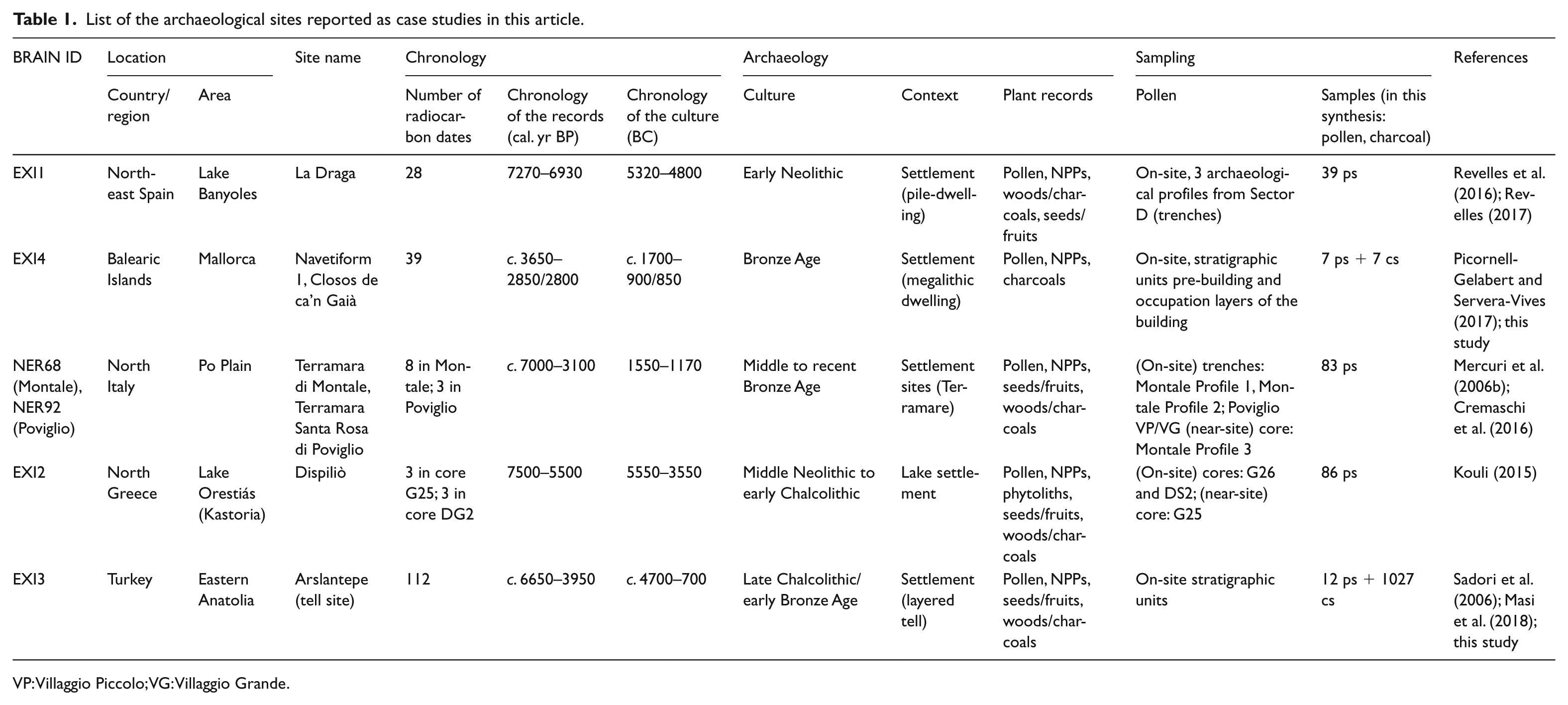
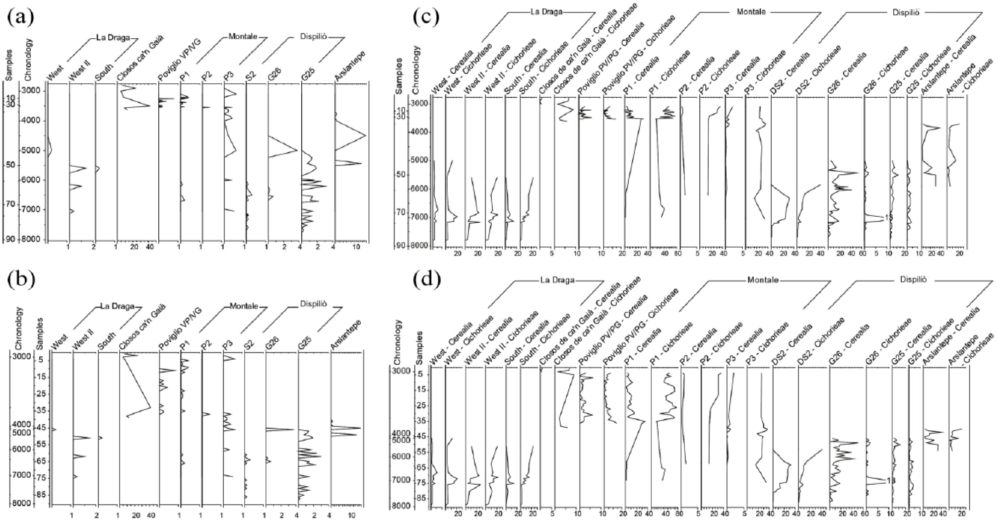
Percentage pollen diagrams from the six archaeological sites: AP% curves plotted according to (a) time and (b) depth scales; Quercus% curves plotted according to (c) time and (d) depth scales.
Western Mediterranean: La Draga (Girona)
NE Spain, Catalonia
Early Neolithic Cardial – 7270–6750 cal. BP
Settlement sites (open-air pile-dwelling on a lake shore)
Sampling: pollen, NPPs; macroremains: seeds/fruits, charcoal
39 pollen samples from three on-site profiles (trenches in archaeological layers)
Key events: AP higher before the settlement and water-rich environment near the Lake Banyoles; exploitation of woods and cereal field cultivation
The first Neolithic farming societies in the Lake Banyoles area settled in a humid and densely forested region (predominantly deciduous Quercus and Corylus avellana). The settlement of La Draga was established in a lacustrine carbonate-sand beach, with alkaline soils poor in nutrients. The dominant vegetation within and in the near surroundings of the settlement would have been aquatic (Potamogeton coloratus, Characeae) with hygrophytes (Cyperaceae, Typha latifolia, Typha-Sparganium, Juncus articulatus type, J. effusus type, Cladium mariscus and Mentha cf. aquatica) in a land with high water availability. A riparian forest formed by ash (Fraxinus), willow (Salix), elm (Ulmus), alder (Alnus), poplar (Populus), elder (Sambucus nigra), laurel (Laurus nobilis) and wild grape (Vitis vinifera subsp. sylvestris) surrounded the beach. Ferns (mainly Pteridium aquilinum) lived in humid environments. Close to surrounding slopes, oak forests grew in deep humid soils, with dominance of deciduous Quercus and the presence of hazel (Corylus), lime (Tilia), pines in the clearances (Pinus), yew in shaded spots (Taxus) and boxwood in the underbrush and colonising degraded areas (Buxus). Conifer forests existed in the mountains (Pinus and Abies), and at regional scale, Mediterranean sclerophyllous forests would have been developed in drier substrates, with evergreen oaks (Quercus ilex-coccifera), wild olive tree (Olea europaea var. sylvestris), Phillyrea, heather (Erica) and rockrose (Cistus; Revelles, 2017).
At the onset of the settlement, oak was exploited for firewood and raw material for construction (attested by charcoal and wood remains, with >1000 oak posts recovered in the 800 m2 of the excavated area; Revelles et al., 2014). Considering the fact that the total extension of the site is estimated to c. 8000 m2, thousands of poles must have been cut for the construction of the settlement, with moreover the period of occupation (López-Bultó, 2015; Revelles et al., 2014). The trunks were cut (with adzes, as shown by traces of the tools; Bosch et al., 2008) and dragged to the settlement. This resulted in significant deforestation and caused soil erosion (Revelles et al., 2016), and the scale of impact was such that it was visible in off-site records some 500 m from the archaeological site (core SB2 in Revelles et al., 2015) and in off-site records that reflect the regional vegetation (Lake Banyoles: Pérez-Obiol and Julià, 1994).
A high presence of cereals (Cerealia-type pollen) is documented in the two occupation phases described at La Draga. Crop fields could not be in the immediate surroundings of the settlement as the site was established in a swampy area unsuitable for cultivation. Cereal fields would have been far enough away to prevent Cerealia-type pollen from reaching the nearby off-site (thus, near site) SB2 core (Revelles et al., 2014, 2015) The high concentrations of Cerealia-type pollen within the settlement reflects on-site storage of crops (mixed cereal grains and chaff suggesting domestic storage were studied by Antolín et al., 2014) and are a by-product of on-site plant processing: at La Draga, spatial association between the highest values of cereal pollen and grinding stones identified an area of cereal processing (Revelles et al., 2017). The comparison of the pollen records from this area (Figure 1) suggests that farming itself caused a limited impact locally and that firewood and timber supply was responsible for major landscape transformations at the extra-local scale (reflected in the near/off-site records: Revelles, 2017).
Western Mediterranean: Closos de ca’n Gaià (Mallorca)
Insular Spain, Balearic Islands
Bronze Age (Naviform BA) to Iron Age – 3650–2800 cal. BP
Settlement, megalithic navetiform house (Navetiform 1)
Sampling: pollen, NPPs; macroremains: charcoal
Seven pollen samples from on-site horizontal sampling; anthracological record from seven archaeological layers
Key events: land transformation since c. 3350 cal BP related to the agropastoral expansion in Mallorca; Olea wood resource management
The Naviform culture developed in the Balearic Islands during the Bronze Age (from c. 3650/3550 to 2800 cal. BP; Lull et al., 2013). Naviform society constitutes the first sedentary megalithic culture established on the archipelago, occupying all the islands’ biotopes. The productive economy was based on cultivation of cereals and pulses (Pérez-Jordà et al., 2017) and on sheep/goat, pigs and cattle husbandry, the former being the most numerous livestock (Ramis, 2017). The Closos de ca’n Gaià settlement included at least five domestic structures (navetiforms), and some of them continued to be occupied throughout Iron Age (Oliver et al., 2017). Navetiforms were monumental domestic spaces, consisting of large buildings with an elongated floor plan, and were inhabited by domestic groups and represented the locus in which the social life was centralised (Fornés et al., 2009). In Closos de ca’n Gaià, the Navetiform 1 has been completely excavated and presents four archaeological phases, ranging from a first occupation previous to the building (Phase 1, c. 3650/3550 – 3350 cal. BP), two subsequent building layers (Phase 2, c. 3350–2950 cal. BP; Phase 3, c. 2950–2800 cal. BP) to the abandonment and subsequent roof collapse (Phase 4, just after c. 2800 cal BP; Javaloyas et al., 2011). Archaeobotanical data show agropastoral and wood management strategies at the site.
During the Bronze Age, the Balearic Islands had predominance of sclerophyllous vegetation (Olea, Pistacia, Cistaceae, etc.; Fyfe et al., 2019) and crop and pasture fields (Burjachs et al., 2017; Servera-Vives et al., 2018). The general picture of the plant landscape, as shown by both anthracological and palynological records from the excavation, is consistent with off-site pollen records from the Gymnesics (Mallorca and Menorca) for this period, with a mosaic landscape dominated by macchia/garrigues and open areas (Figures 2 and 3). The pre-megalithic occupation of the site (Phase 1) was perpetuated by the construction of the Navetiform building (Phase 2), a monumental house that was continuously occupied for several centuries (Javaloyas et al., 2011, 2013; Oliver et al., 2017).
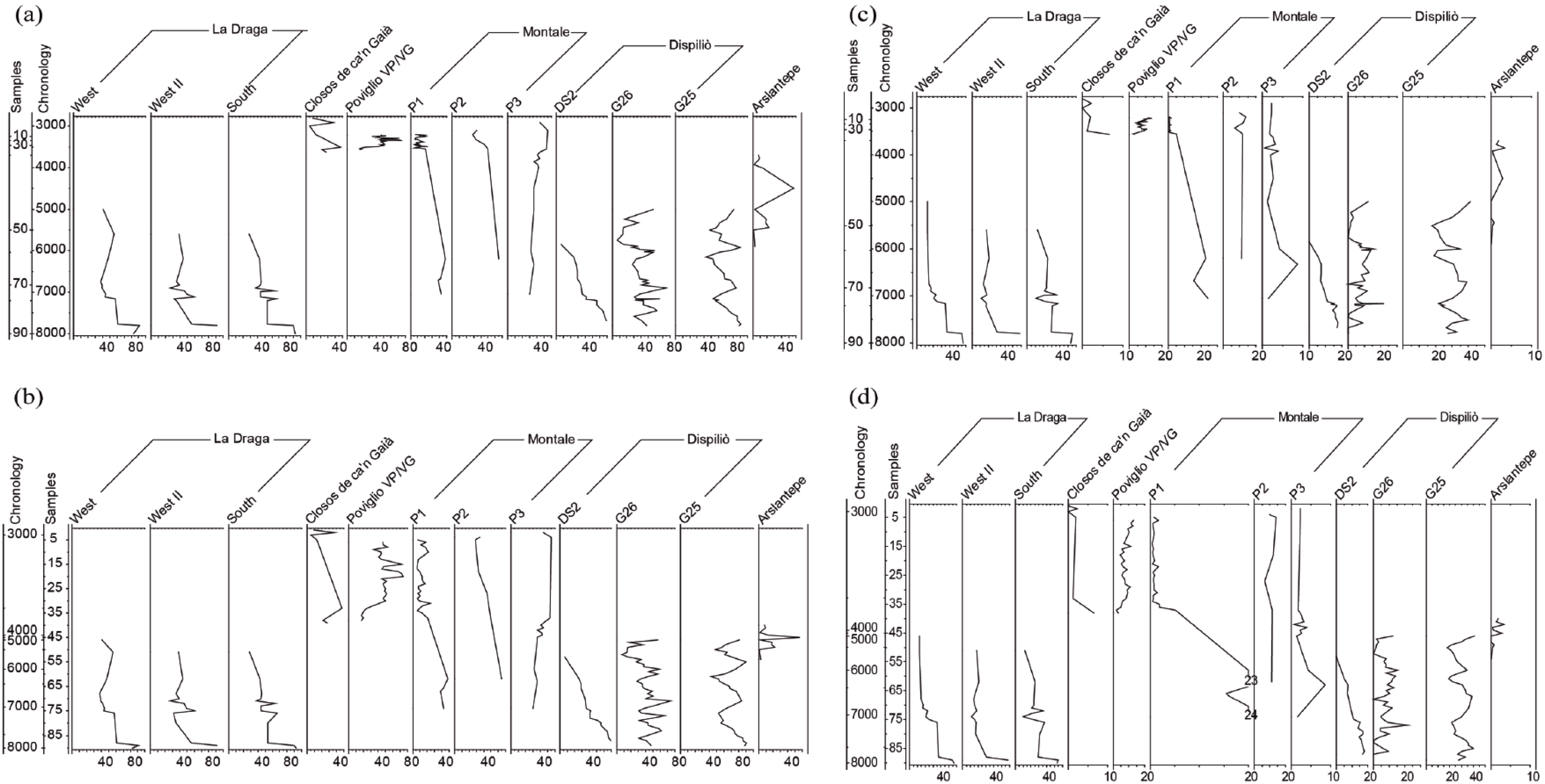
Anthracological diagrams based on anthracological analysis of the sites of Arslantepe, Turkey (Masi et al., 2018), and Closos de ca’n Gaià, Mallorca (Picornell-Gelabert and Servera-Vives, 2017). Results at Closos de ca’n Gaià are presented with percentage (%) of charcoal fragments per taxon at every archaeological layer (stratigraphic units) and occupation phase of the Navetiform 1 building. Results at Arslantepe are presented with percentage (%) of charcoal weight per taxon at every archaeological layer of the site. Dots represent values <3%.
Starting at c. 3350 cal. BP, there was a general decrease of arboreal pollen matching the expansion of weeds, synanthropic taxa and grasslands. This correlates with archaeological data for increasing land use. The exploitation of forest resources for firewood became quite specialised: (wild-)olive dominates the charcoal assemblages, while shrubs such as Rhamnus/Phillyrea and Pistacia lentiscus become less used or available compared with the previous phase.
The integration of pollen and charcoal data mainly suggests that before the building (Phase 1) landscape exploitation strategies were focussed around use of olive tree and understorey forest species for firewood provisioning and moderate agropastoral activities in a semi-open environment surrounding the site. Following a noticeable landscape disruption associated with Phase 2 (c. 3350 cal. BP), pastoral activities expanded and (wild-)olive wood exploitation intensified for firewood collection. Then, data show a variability in Phase 3 that probably reflects the spatial distribution of samples within the house, reaching higher values of anemophilous tree pollen in the front area, near the only entrance to the building (SU 9), compared with the inner one (SU 35; see the charcoal from these SU in Figure 3).
The high values of API and Olea charcoal fragments, found also in the roof collapse sample (Phase 4), testify to the land uses of the last occupation phase. This sediment is likely the result of the roof construction/maintenance and the subsequent post-collapse sedimentation in a context where the neighbouring navetifoms of the settlement were still inhabited after the Bronze Age.
The overall picture is that the Navetiform culture had a visible impact on the local lands, as well as regional impact that became therefore visible in the only off-site record available for Mallorca in the Albufera d’Alcúdia record (Figure 1; Burjachs, 1994; Burjachs et al., 2017). This sequence shows the prevalence of thermophilous and sclerophyllous taxa (e.g. Olea, Pistacia, etc.) during Bronze Age chronologies. Moreover, the increase of Artemisia, the high values of Plantago and the presence of Rumex highlight the existence of noticeable human activities in the area during this period.
Central Mediterranean: Terramara di Montale-Modena and Terramara Santa Rosa di Poviglio-Reggio Emilia (North Italy)
N Italy, Emilia-Romagna: Terramara di Montale-Modena, Terramara Santa Rosa di Poviglio-Reggio Emilia
Middle to Recent Bronze Age –3600–3170 cal. BP
Settlement sites (open-air pile-dwelling, and then villages, in river meanders)
Sampling: pollen, NPPs; macroremains: seeds/fruits, charcoal
83 pollen samples from three on-site and one near-site series (trenches)
Key events: AP higher before the settlement of Montale, and water-rich environment near the rivers in the Po Plain; exploitation of woods and cereal field cultivation
The Terramare civilisation developed in the Po Plain during the Middle and Recent Bronze Age (1650–1170 BC; Bernabò Brea et al., 1997), in a quasi open-land with fertile soils, rich of water and nutrients from the river floods. Before the onset of terramara settlements, the landscape was largely natural with a fairly sparse, open canopy, forest growing in the area. Woods mainly consisted of deciduous Quercus and Carpinus betulus prevailing in mixed oak forests with Acer, Fraxinus excelsior type, Ostrya carpinifolia, Tilia, Ulmus and Corylus avellana. They were also mixed with conifer (Pinus and Abies), whose woods were abundant during the early Holocene and were partly replaced by Fagus in the hills and mountains and by mixed oakwoods in the lower belts. At the onset of settlements, a sudden decrease of trees in pollen spectra mark the impressive use of woods for construction of houses (Quercus for piles, and Fraxinus and other trees for house walls) and palisades (Carpinus betulus; Mercuri et al., 2006b). Thousands of poles and posts, including charred trunks, have been discovered at the base floor of these archaeological sites (e.g. Rottoli, 1997). Reduction of Alnus pollen, alongside an increase in hydro-hygrophytes, has been interpreted as the clearance of river banks and construction of ditches (Mercuri et al., 2006b: 56). The deforestation in the Po Plain was so extensive that it is visible even in off-site records (e.g. Adriatic Sea core RF93-30 which received sediments from the Po valley: Mercuri et al., 2012).
Each terramara consisted of a fortified village, with rows of houses surrounded by an embankment and a ditch. Its area of influence (the territory exploited and/or cultivated) was dependant on the size of the settlement, its distance from other sites and the chronological phase (Cardarelli, 1988). Terramaras were close to each other (>220 sites have been discovered only in the province of Modena), one per 9–10 km, and sometimes per 2 km, with population estimates of c. 150,000 people in the later phase (Cardarelli, 1997; Cremaschi, 1997). Terramara di Montale is among the best studied sites. It had eleven occupational phases, with houses often destroyed by fire and was settled in a south-eastern position, near the Apennines. Terramara Santa Rosa di Poviglio had two main phases, developing from a ‘small village’ (Villaggio Piccolo-VP) to a ‘large village’ (Villaggio Grande-VG).
A high presence of cereals (Cerealia-type pollen) is documented in all the sites (Mercuri et al., 2006a). Cereals were grown close to each village as their pollen records (Cerealia-type) are always detected in near-site sequences, and high values in on-site sequences are connected with plant transport and processing near the houses (Figure 4). Some plots were cultivated for fodder (Fabaceae, including Lotus, Medicago, Melilotus, Trifolium) or left for fallow/grazing in the area of influence; the area of influence was surrounded by forests supplying wild fruits and defensive functions (Mercuri et al., 2015c). Comparison of on-site and near-site (P3) pollen records suggests that cereal fields were mostly cultivated towards the west around Montale, possibly in rotation or intercropping with legume fields (Mercuri et al., 2006a), whereas domestic animals were kept inside the settlement (presence of dung and archaeozoological remains) and browsed grasses and fodder plants in small parcels and pastures rich of Cichorieae, all within the area of influence. Trees and wood management have a special role in this society, and first signals of Vitis cultivation emerged (Cremaschi et al., 2016; Mercuri et al., 2006b, 2015a). At the end of the Recent Bronze Age, this society rapidly vanished, probably forced by a combination of climatic, environmental and socio-economic causes (Cremaschi et al., 2016).
Percentage pollen diagrams from the six archaeological sites: OJC%curves plotted according to (a) time and (b) depth scales; Cereals and Cichorieae% curves plotted according to (c) time and (d) depth scales.
Eastern Mediterranean: Dispiliò (northern Greece)
N Greece Neolithic-Chalcolithic – 7750–5150 cal. BP
Settlement site (on lake shore)
Sampling: pollen, NPPs, phytoliths; macroremains: seeds/fruits, charcoal
86 pollen samples from two on-site and one near-site series (cores)
Key events: exceptional location and long-time continuative occupation, at the shore of Lake Orestiás; cereal field cultivation in a diversified kind and intensive exploitation of natural resources
Dispiliò, near Lake Orestiás, also known as Lake Kastoria, is the first lake settlement systematically investigated in Greece. According to joint archaeological and radiocarbon data (Facorellis et al., 2014), the site was occupied for about 2000 years, from the middle Neolithic (7500 cal. BP) to the Chalcolithic (5500 cal. BP) representing one of the earliest locations with unambiguous evidence of human disturbance in Greece. Earlier agropastoral activities associated with the early Neolithic communities have been observed starting from at least 8300 cal. BP in eastern Macedonia (Glais et al., 2016).
The establishment of the Dispiliò settlement (c. 7500 cal. BP) took place within a landscape characterised by dense woodland cover. Mountainous coniferous forest and smaller areas with Fagus forest existed on the higher altitudes around the lake basin, whereas mixed deciduous oak forests with Carpinus orientalis/Ostrya type, Corylus, Crataegus monogyna and Ulmus covered intermediate and lower altitudes. Human activities resulted in the development of a mosaic of habitats in the surrounding area, reflected by local pollen assemblages that correspond to different kinds, or intensity, of exploitation of natural resources in space and time (Kouli, 2015; Kouli and Dermitzakis, 2008).
Three periods of retreat of natural woodland and of major anthropic disturbance have been recognised, especially at intermediate altitudes. These are correlated with the three periods of major constructing activities described by the archaeological study (Hourmouziadi and Yagoulis, 2002; Sofronidou, 2008). Two of them, corresponding to the Middle Neolithic (c. 7200 cal. BP, ending with the destruction by fire of the settlement; Karkanas et al., 2011) and Late Neolithic II to Chalcolithic (c. 6000 cal. BP) show evidence of intensive cultivation. Two episodes of woodland recovery are characterised by decrease of anthropogenic indicators in pollen spectra, representing a pause of pastoral activities between the major construction phases.
The inhabitants of Dispiliò were both agriculturalists and animal herders, but the kind and intensity of those activities were not consistent through time. Following the establishment of the settlement, cultivation produced abundant cereal pollen in the deposits, and cultivation remained one of the major activities of the Neolithic society. Pastoralism seems to have been a significant and diachronic activity, more intensively practised in the first phases of the settlement. The peak of animal breeding is recorded at c. 6400 cal. BP, reducing in importance afterwards while the peak in evidence for cereal cultivation is during the final occupation period of the Late Neolithic II-Chalcolithic. The on-site/near-site comparison demonstrated that cereal fields were cultivated in the close vicinity of the houses, in ‘garden-like’ fields (Mangafa, 2002), whereas herds were kept around the settlement and not inside (Kouli, 2015).
Eastern Mediterranean: Arslantepe (Anatolia)
E Turkey; Late Chalcolithic, Late Uruk, Early Bronze Age – 6650–3950 cal. BP
Settlement site (layered tell)
Sampling: pollen; macroremains: seeds/fruits, charcoal
12 pollen samples from on-site (short trenches); anthracological record from seven archaeological layers
Key events: several sudden changes of populations followed one another in the settlement, implying continuous changes in occupation patterns and land use
Arslantepe is located in the modern Malatya plateau, a region characterised by low precipitation both today and during prehistory. A large hydrogeological karst catchment supplies water to the plain allowing extensive agriculture since at least the Chalcolithic Age (Masi et al., 2014). The site was settled several times at the same place, forming a tell in an open landscape characterised by trees such as deciduous and semi-deciduous oaks (Quercus sp.), elms (Ulmus), ashes (Fraxinus) and shrubs as junipers (Juniperus). The presence of a spring at the base of the tell and of a number of others in the close surroundings, favoured the growth of alders and poplars.
The palynological data come from seven archaeological phases ranging from Late Chalcolithic 1–2 (6500 cal. BP, VIII period) to Early Bronze Age III (4000 cal. BP, VID2 phase). Contrasts between the charcoal and pollen records for tree taxa reveal important aspects of landscape exploitation. The pollen rain/human mounds show only low quantities of arboreal pollen. The human selection of timber appears to be quite clear: the charcoal record shows a dominance of deciduous Quercus followed by hydrophilous (Alnus, Populus, Tamarix) and hygrophilous (Fraxinus, Ulmus) trees (Figure 3; Sadori et al., 2006). These abundant taxa are either poorly represented in the pollen record (deciduous Quercus) or not present at all (Alnus). Castanea, Juglans and Corylus present in the pollen samples are not found either in the charcoal or seed records.
The results indicate that woody plants were mainly exploited from woody steppe/shrubland in which Rosaceae played an important role and from the riparian vegetation. Mountain taxa such as Juniperus, and Pinus play only a minor role. The selection of the timber appears mainly linked to the different cultural and socio-economic traits of the Arslantepe communities. Palaeoclimatic reconstruction based on stable carbon isotope demonstrated that environmental changes played only a marginal role in the different wood exploitation (Masi et al., 2013a, 2013b; Vignola et al., 2017, 2018). Charcoal analysis shows important changes in plant use not matching the environmental changes. The different occurrence of taxa according to the depositional context highlights that the hydrophilous plants prevail in building structures, with the exception of the c. 4900–4500 cal. BP period: isotope data demonstrate that during this period, there was an increased humidity; nevertheless, there was a prevalent use of woodland-steppe plants (Masi et al., 2018).
There are no off-site pollen records for reconstructing extra-local or regional vegetation. The closest is the Lake Van record (300 km far from Arslantepe) with tree pollen between 40% and 50% during Chalcolithic and Early Bronze Age levels (Wick et al., 2003).
Results and discussion
Comparing data, sites and land uses
The detailed data from the archaeobotanical studies described here provide information about the ‘small histories’ of land use in single sites from different regions. However, major common themes in plant exploitation can be revealed by the comparison of the main pollen curves from all sites and show the variability of this history at a regional scale.
The percentages of total AP and Quercus pollen (Figure 2) outline the role of trees in prehistory as a substantial and indisputable natural resource (for fuel, construction, metallurgy, tools and ploughs, and wild fruit picking). The different diagrams show similar general patterns: (1) the trends of decrease of woodland cover (also possibly reflecting climatic changes?), (2) declines in trees at the onset of settlement, (3) notable declines in oaks in particular within the deforestation events (e.g. at La Draga and in the Terramare), (4) alternative cycles of retreat and recovery of woodland depending on intensity of human activities (e.g. at Dispiliò), (5) elevated local representation of oak pollen due to the transport of wood into the site (e.g. Arslantepe, where oaks prevails also in the anthracological record: Figure 3). Human-related declines in AP/Quercus match usage for house/palisade buildings and fuel for metallurgy, while other activities, such as fruit collection, may rely on tree survival and wood management. Care for the survival of trees may have been the case of high pollen values of Juglans at Arslantepe or of Corylus and Vitis at the Terramara Santa Rosa di Poviglio. The different local availability of the Mediterranean vegetation caused the major use of Olea wood at Closos de ca’n Gaià (Figure 3).
The trends of both the OJC tree sum and the Cereals versus Cichorieae herb sums are among the best indicators of land use (Figure 4). There are signals of cultivation and pastoral activities in all the sites, but their representation is variable. OJC are present but sporadic, fragmentary evidence in the archaeological sites (except Olea in Closos de ca’n Gaià). This seems to be in contrast with what may be visible in some off-site records (Mercuri et al., 2013b; Stoddart et al., this issue). Cultural trees were grown or cultivated far from the settlements: they were cared for, managed but not transplanted near the sites, and sites seem to have not been settled near stands of these (even wild) trees. At a regional scale, the increase of the OJC curve appears later, around 3000–2700 cal. BP in off-site records, when arboriculture begins in central Italy (Mercuri et al., 2002; Stoddart et al., this issue).
Instead of trees, crop fields were established and cultivated close to the sites. Representation of cereals in on-site records can be very high due to plant processing from the very start of use of the site (as at La Draga and Montale), or during the life of the settlements (e.g. Dispiliò and Arslantepe). The regularly opposite trends of cereal and cichory pollen (at La Draga, Montale, Dispiliò; Figure 4) marks the alternation (either replacement or rotation) of crop fields and pastures as alternative/complimentary land uses over these prehistoric times in different contexts and countries. While increases in cichory may suggest abandonment of fields, it appears to correspond to a real alternative (pastoral) land use. This practice, even if casually introduced and then maintained, had the advantage of adding manure to soils (from the dung of browsing animals) following some years of high nitrogen-demanding cereal cultivation.
All the sites were settled near wet environments, surrounded by grasslands and mixed oakwoods, and with variable amount of synanthropic taxa (Figures 5 and 6).
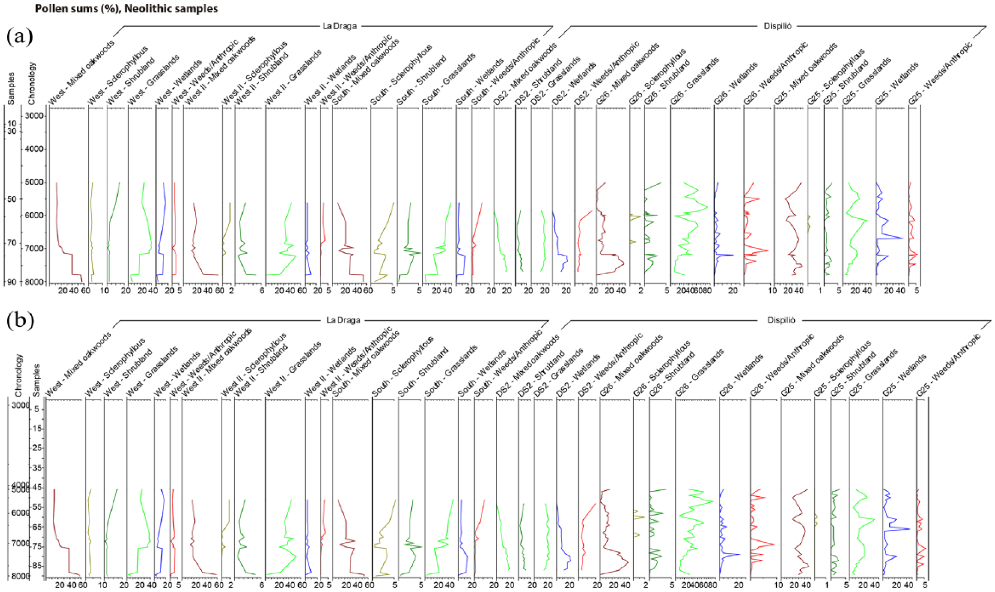
Percentage pollen diagrams from the archaeological sites: pollen sums of the two Neolithic sites La Draga and Dispiliò describe the mixed oakwoods, sclerophyllous, shrubland, grasslands and wetlands as mainly natural component of the landscape, and weeds/anthropic plants as signs of human-influenced environment. Pollen sums curves are plotted versus (a) time and (b) depth scales.
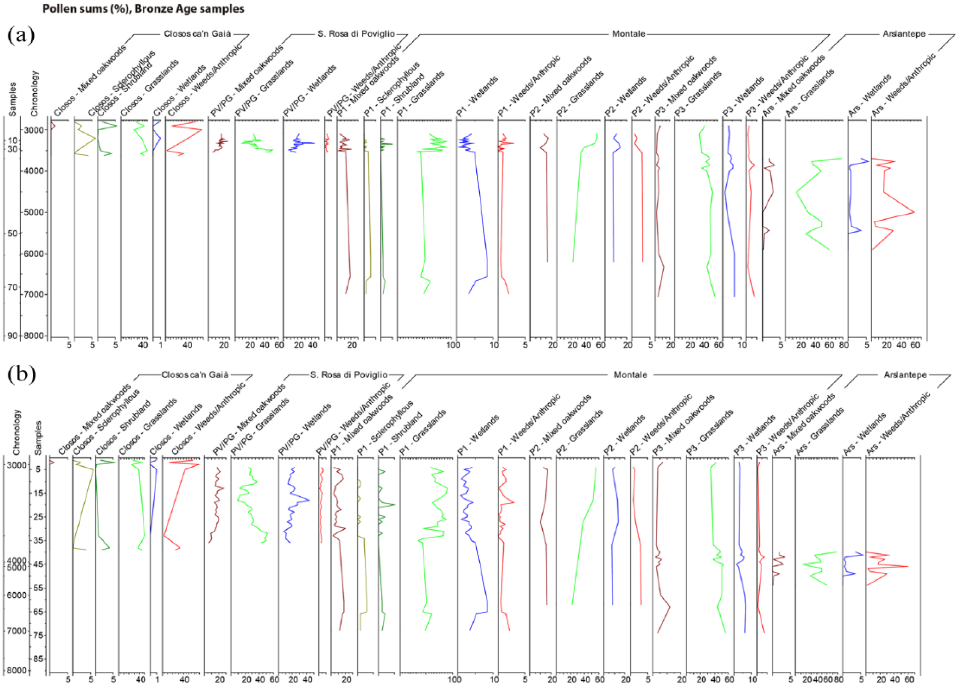
Percentage pollen diagrams from the archaeological sites: pollen sums of the four sites with samples of the Bronze Age showing mixed oakwoods, sclerophyllous, shrubland, grasslands and wetlands as mainly natural component of the landscape, and weeds/anthropic plants as signs of human-influenced environment. The curves plotted according to (a) time and (b) depth scales show better resolution for the Bronze Age samples.
The PCA, based on individual taxa, besides all the sums considered above, provides further data comparison showing that the wild and synanthropic pollen taxa cluster differently along the Axis 1 and Axis 2 principal component functions (Figure 7). The samples are organised mainly by vegetation types and fall along a forested to an opened landscape gradient. Interestingly, the samples of each site cluster within the ordination plot, with little overlap between sites. This shows that sites have their own features and suggests that Neolithic and Bronze Age sites have different focuses on land uses and cultural skills.
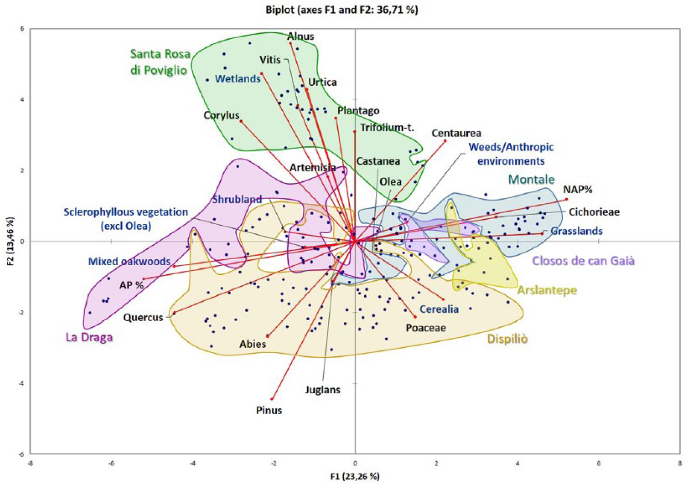
Principal Component Analysis (PCA) of selected pollen taxa and sums from the six archaeological sites included in this article (samples are plotted as variables). Axis 1 separates the samples along a woody landscape gradient (from forested towards more open environments), while Axis 2 groups them mainly by vegetation types (pasturelands and riparian forests against more forested environments and crops). Each site is well separated to the others and shows own features.
The sites with a higher number of samples (La Draga, Poviglio, Dispiliò and Montale) show an elongated distribution in relation to Axis 1, representing the highest variability probably related to the long-term vegetation and land-uses changes. As described, the gradient along Axis 1 represents a transition from more forested (lower values) to more open vegetation (higher values). The Neolithic lakeshore sites of La Draga and Dispiliò cluster along more forested landscapes according a gradient ranging from the more wooded environments (especially La Draga) towards more opened landscape (Dispiliò). Both sites are linked to crops and forested landscapes according to their position on Axis 2, rather than pasturelands. The Italian Bronze Age sites of Poviglio and Montale cluster differently: on Axis 2, the first site is linked to pastureland and wetlands, while the second mainly to grasslands and anthropic environments. The position of their samples on Axis 1 shows a predominantly open landscape. Closos and Arslanstepe show positive values in Axis 1 indicating their relation to more opened areas. Both sites are characterised by open woodlands with scattered pasturelands and crops.
The PCA confirms the different relationships with the environment during the Neolithic and the Bronze Age, underlying an increasing importance given to wood exploitation over time.
From Neolithic to Bronze Age land use
In the earliest times, hunter-gatherers had a ‘less permanent’ interference with vegetation dynamics because both humans and plants were part of the same ecosystems. Although intermediate forms of environment exploitation between gathering and food production have been recognised in the Levant and the Sahara (Clarke et al., 2016; Mercuri et al., 2018; Willcox et al., 2012), evidence for this in Mediterranean records is weak and still hard to investigate. The increase of sedentism resulted in communities exploiting the same territory over long periods of time, agriculture expansion and technological development, causing a deeper transformation of the landscape (Mercuri et al., 2011).
Despite the different chronological phases and social organisation, and based on the morphological and botanical geographical features, the trend of landscape transformation in the different Mediterranean regions may be regarded as having some similar trends. First, anthropogenic influence on plant cover, soils and waters first occurred in the vicinity of settlements, and all archaeological sites preserve evidence of API. Second, actions on the environment and development of forestry alongside agriculture caused the expansion of human influence on the environment, and the local pressure expanded towards a regional impact, becoming recognisable in off-site records more distant from the archaeological sites (Asouti and Kabukcu, 2014; Kouli, 2015; Mercuri et al., 2010). Human impact at a regional scale depends on cultural variables, demography, distance from the settlement sites and the intensity of activities undertaken. Holocene climate variability and instability, forest clearance and management, wood exploitation for metallurgy, crop cultivation, animal breeding and pastoralism are the primary agents that have transformed land cover in the Mediterranean landscape. Palynology from archaeological sites (so-called on-site palynology) is essential to recognise the first influence of humans, as activities begin in/close/next to the occupied/settled sites. It also allows us to recognise and categorise the type of land-use activities undertaken, sometimes also inferring its intensity by combining archaeobotanical data with archaeo- and geo-data.
The sites of La Draga (7270–6750 cal. BP) and Terramara di Montale (3550–3200 cal. BP) show similar land-use dynamics implying oak exploitation, causing local deforestation, and cultivation of cereal fields in the area or around the site. Despite the different chronology and culture, tree decreases and the subsequent soil erosion were so extensive that evidence can be found even beyond the sites (Oldfield et al., 2003; Revelles et al., 2015). Nevertheless, there are clear differences between the Neolithic influence and the Bronze Age impact.
According to Revelles (2017: 441) Early Neolithic human actions have been recorded at different degrees of intensity on local and extra-local scales in the area of Lake Banyoles (the region in which La Draga is situated). The signal of farming is only identifiable in on-site records, confirming the limited impact of cereal cultivation by the first farmers. While deforestation is not visible in the core from Lake Banyoles, it is in core SB2, closer to La Draga (Figure 8). The core SB2 can thus reflect the scale of the area of influence of the settlement and can be considered as a ‘near-site’ core. This mirrors different pollen production, distance of the pollen sources from the site, transport of plants into the site and intensity of the human action in transforming the landscape (Mercuri, 2014). The process of deforestation was not monotonic, as broadleaf deciduous forests recovered during the later Neolithic after the end of human pressure in northeast Spain (Revelles, 2017; Fyfe et al., this issue). In northern Greece, similar woodland dynamics occurred during the settlement development and Neolithic land use at Dispiliò, following occupation and temporary abandonment phases, but again the process is not visible in the off-site core of Lake Dojran (Figure 8; Kouli, 2015) or in the woodland vegetation clusters of northern Greece (Weiberg et al., this issue).
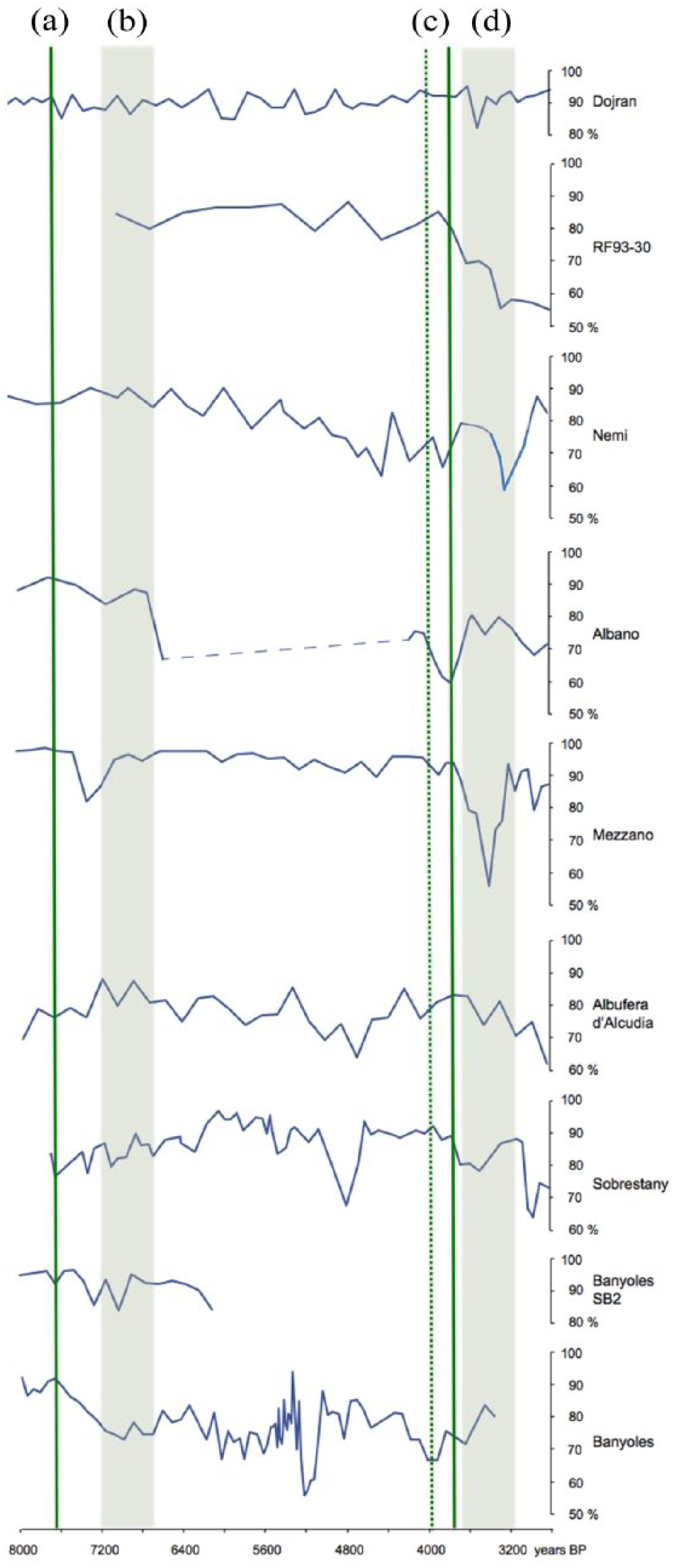
The AP% trends of off-sites may be useful to observe the regional effect of the local human activities inferred from on-sites (the archaeological sites) of the same area; these AP curves show oscillations that have ambiguous/dual natural anthropic causes (references in the text). They depend on human activities only if the sampling sites lies in the area of influence (near-site) of the archaeological settlements where people was exploiting woods: (a) beginning of Dispiliò, (b) lifetime of La Draga, (c) Bronze Age at Closos (beginning) and Arslantepe (end phase), and (d) Terramare culture.
Three thousand years later, in eastern Anatolia, groups of people at Arslantepe exploited the oaks and hydro-hygrophilous trees, not only searching for the most available (those arid highlands were almost treeless or covered by shrublands), and were highly selective of the timber most suitable for building and fire. In northern Italy, the Terramare villages settled on the Po Plain. Because settlements need space and houses, considerable deforestation supplied timber for houses, palisades, furnaces and tools. Population levels and technological skills gave this culture both the motivation and ability to deeply shape the landscape, changing the river courses and the distribution of woods and open spaces (Cardarelli, 1997; Cremaschi, 1997). This transformation became irreversible leaving traces in off-site pollen diagrams distant from the area (Mercuri et al., 2012). Terrestrial cores such as lakes of Albano and Nemi show evidence of rapid forest changes, probably reflecting the proximity of other archaeological sites present in the peninsula (as shown by BRAIN). These lakes can be, therefore, classified as near-sites as, for example, the Bronze Age ‘Villaggio delle Macine’ is still visible at the shores of Lago Albano.
In the later Bronze Age phases, the people of Closos de ca’n Gaià selectively exploited (wild) olive wood and other sclerophyll species for different purposes, confirming that local wood was a very good, versatile, natural resource and the inhabitants of Mallorca learned how to exploit it (Picornell-Gelabert and Servera-Vives, 2017), possibly also spreading plants.
Transport of trunks might have been a hard task and thus may be reasonably considered a local (near-site) activity, and as mentioned above, the manipulation of trees has left marked signals in pollen diagrams. In the Mediterranean, however, off-site records often contain API and archaeological survey demonstrate that human traces are spread all over entire regions (Mercuri et al., 2011; Roberts et al., this issue; Weiberg et al., this issue). From the Neolithic onwards, it is difficult to find records that are wholly ‘natural’. Traces of human influence or impact can be found even in sequences collected at 30–40 km distance from one particular site, both because of the proximity of other sites and of the regional spread of the impact in the areas of influence of the archaeological sites which increases through time.
The off-site records are useful in demonstrating that natural sequences in the Mediterranean area are rare due to the long history of presence and land use by the civilisations that occupied these territories even before the Neolithic. For example, off-site records can intercept anthropic signals when (1) the sites are close to archaeological sites (e.g. lake shores settled by pile dwellings: Lago Lucone, Valsecchi et al., 2006; Lago Mezzano, Sadori, 2018), (2) the human action is extensively spread in the area, and (3) the cores collect sediments from regions modified by human activities (Adriatic RF93-30 shows unambiguous signs of land use in the Po valley; Mercuri et al., 2012), (4) the land use is definitively turned to a land-cover transformation at regional scale (e.g. Mensing et al., 2018). All considered, the archaeological sites discussed in this article testify to a diversified set of land uses at each cultural phase. At La Draga, people practised forest exploitation and cereal cultivation, at Dispiliò people performed husbandry and farming, while people at Arslantepe stored impressive quantities of cereals and exploited oaks. The Terramare culture was able to manage the forest and performed a diversified agriculture with crop cultivation and animal breeding at the same site, while the Navetiform groups practised a combined activity of understory and olive tree exploitation with pastoral activities.
Conclusion
Archaeobotany and the interpretation of data from on-site studies demonstrate that land use has been a multifaceted process involving original and repetitive human behaviour. Since the Neolithic and into the Bronze Age, people have adopted a diffuse pattern of land use involving a combination of diverse activities performed in the same territory. The most recurrent combinations included wood exploitation, field cultivation and animal breeding, and the set of activities provided the ensemble of timber/fuel, crops/food, and milk/meat, respectively. Considering that land use is a subsector of the human impact, this conclusion confirms that ‘human impact is a collective concept including the ensemble of adaptive strategies, technological outputs and interferences between cultural needs and natural ecosystem dynamics’ (Mercuri et al., 2015b:136).
The presence of cultures in Mediterranean lands is impressive. Each lived in different territories with their own characteristics and identity. The archaeological approach tends to consider one activity – one type of economy – one adaptation strategy prevalent over others in a way that each culture seems to have been centred on one type of land use. However, pollen and other plant records tell us that different land uses co-existed at the same site in the Mediterranean.
Although it is true that different land use activities were performed by different cultures, archaeobotanical data show that different uses of natural resources have been performed by the same culture (and we can also argue that possibly different people, as today, were involved in different works, depending on the social organisation and degree of specialisation within communities). This skilful way allowed communities to exploit the full spectrum of natural resources offered by the Mediterranean biodiversity, and helped people to cross the environmental instability of the mid and late Holocene. Local signals of the different land uses are evident at each site, confirming that this has been an ancient and common pattern, even when they are not evident or soft/thinner in the off-site records where we cannot be sure that the same land space was used for different purposes.
Agriculture and forestry have become progressively more specialised and intensive in the Mediterranean and are facing global environmental and economic challenges in common with many other regions of the world. The lesson from the past – here from prehistory – is that the multifunctional land use, combining sylvo-pastoral and crop farming mixed systems, is more sustainable than monoculture and a promising way to develop the rural economy. Multifunctional land use is not only recognisable at regional scale (where it may be ambiguous because plant records in one point synthesise a large area) but is especially evident in pollen and charcoal/macrobotanical records at the site scale. The multifunctional exploitation of the area of influence in each site can be regarded as a clever strategy that acted on reducing the pressure on the environment of permanent settlements facilitating the life of sedentary people. What is generally considered a recently lost strategy of traditional agriculture, in use during the last two centuries, seems to have been an important practice and adaptive human behaviour during the Holocene of the prehistoric Mediterranean.
Footnotes
Acknowledgements
A.M.M. planned with A.F. and wrote the main text; J.R. and F.B. studied La Draga; K.K. studied Dispiliò; L.S., A.M. and M.G. studied Arslantepe; L.P.G. and G.S.V. studied Closos de ca’n Gaià; A.M.M., P.T. and A.F. studied terramaras; R.F. promoted the teamwork and improved the English; A.F., L.P.G. and G.S.V. elaborated data; A.M.M., L.S. and G.S.V. prepared the diagrams. All authors shared data, wrote the relevant parts of the text, and read and approved the final manuscript. A.M., M.G. and L.S. wish to acknowledge Marcella Frangipane and Francesca Balossi Restelli for the continuous advice in the study of the plant remains from Arslantepe; a special thank is due to Cristiano Vignola for his help in pollen sampling.
Funding
The research on the Terramare culture is part of the activity of the project SUCCESSO-TERRA (Human societies, climate/environment changes and resource exploitation/sustainability in the Po Plain at the mid Holocene times: the Terramaras; Ministero dell’Istruzione, dell’Università e della Ricerca PRIN-20158KBLNB; coord. Mauro Cremaschi, University of Milan, entrusted to A.M.M. The research at Closos de ca’n Gaià has been founded by Ajuntament de Felanitx, Consell Insular de Mallorca, and the research project is financed by the Spanish Ministry of Economy and Competitiveness: ‘Archipelagos: landscapes, insular prehistoric communities and connectivity strategies in the western Mediterranean. The case of the Balearic Islands during the recent prehistory (2500–123 BC) (HAR2015, 67211-P)’. The work of G.S.V. has been funded by ‘Programa Vicenç Mut d’Incorporació de Personal R + D + I (Pla de Ciència, Tecnologia, Innovació I Emprenedoria 2013–2017) de la Vicepresidència I Conselleria d’Innovació, Recerca i Turisme del Govern de les Illes Balears i el Fons Social Europeu (PD-018-2017)’. The work of L.P.G. has been funded by the Ministry of Economy and Competitiveness of Spanish Government (Juan de La Cierva Program: IJCI-2015-24550). The work of K.K. was funded by EU & GSRT/Greece (PENED95ED1983) and NKUA project (KA14168). This paper was stimulated by a workshop at the Santuari di Lluc, Mallorca, in September 2017, funded by the Leverhulme Trust (Grant number: RPG-2015-031).