



Abstract
Measurements of mineral magnetism were performed on a sediment sequence recovered from Foye Chi, an alpine lake (3410 m a.s.l.) on the southern slope of the Taibai Mountain (3767 m a.s.l.), the highest mountain in east mainland China (east of 105°E) influenced by East Asian summer monsoon (EASM) and East Asian winter monsoon (EAWM). Mineral magnetism were also measured for surface sediments from the lake, rock debris, surface soils and a soil profile from its catchment and surface soils at the elevations of 600–3767 m a.s.l. of the southern slope of the Mountain. AMS14C dating, analyses of pollen, particle size, TOC, TN and δ13Norg were conducted for the sediment sequence while pollen analysis was also made for the surface-sediment sample. Variations in χlf, χARM, IRM300mT and SIRM of the sediment sequence were attributed to changes in erosion intensity, while those in IRM20mT/ARM and particularly χARM/SIRM to changes in soil maturity. With aid of the other data, the magnetic data of the sediment sequence revealed environmental changes over the past ~5520 years. The weighted χARM/SIRM values of the sediment sequence in comparison with χARM/SIRM of the surface soils distributed on different elevations allowed estimating the altitudes where the present environments are similar to the past ones for different periods of the past ~5520 years. The reconstructed environmental changes are generally in agreement with the centennial-scale variability of EASM indicated by a stalagmite 18O record and with that of EAWM indicated by an 18O record of planktonic foraminiferal.
Keywords
Introduction
Taibai (3767 m a.s.l.) is the highest mountain in east mainland China (east of 105°E) that is influenced by East Asian winter monsoon (EAWM) and East Asian summer monsoon (EASM) (Figure 1). The Mountain is also the peak and central massif of the Qinling Mountain Range (Figure 1). The Mountain Range is the boundary between the subtropical climate zone to the south and the moderately warm temperate climate zone to the north in east China (Figure 1). Botanically, it separates the evergreen broadleaved forest zone to the south from the deciduous broadleaved forest zone to the north (Figure 1). Therefore, the Qinling Mountain Range has been customarily regarded as the ‘dividing-line’ between the ‘south’ and ‘north’ in east China.

Qinling Mountain Range in the vicinity of Chinese Loess Plateau and Mu Us Desert, Taibai Mountain, Foye Chi (the study site) and two other places mentioned in the text.
The high altitudes (>3000 m a.s.l.) of the southern slope of the Taibai Mountain had been covered by glaciers during the late Pleistocene. The glaciers melted since the onset of the Holocene when it was comparatively warm in general. Water has gathered in the cirques and cirque stairways, forming small lakes called ‘hai’ or ‘chi’, meaning ‘sea’ or ‘pond’ in Chinese (Figure 2). These water-bodies are the only alpine or sub-alpine lakes at the altitudes >3000 m a.s.l. in east mainland China (e.g. Rost, 2000; Tian and Huang, 1990). Previous investigations have shown that alpine or high-altitude lakes are particularly suitable for climate-change studies (e.g. Jiménez-Moreno et al., 2013; Lou and Chen, 1997; Ma et al., 2009; Xiao et al., 2014; Zhu et al., 2010). Depositions in the lakes on the Taibai Mountain have been less anthropogenically disturbed than those in the lakes at low and relatively low altitudes in the densely populated east China and thus may provide more reliable records on environmental changes particularly for the late mid- and late-Holocene (e.g. Cheng et al., 2017; Gao et al., 2018; Song et al., 2016; Wang et al., 2010, 2016; Zhang et al., 2015). So far, records of centennial-scale variability of EAWM are still sparse in general owing to the limited number of suitable archives and proxies (Sagawa et al., 2014). On the other hand, records of centennial-scale variability of EASM are mainly based on analyses of δ18O of stalagmites (Hu et al., 2008). Records from these alpine or sub-alpine lakes on the Taibai Mountain in the monsoon-dominated region are also likely to add sedimentary evidence on centennial-scale variability of both EAWM and EASM occurring during the late mid- and late Holocene.
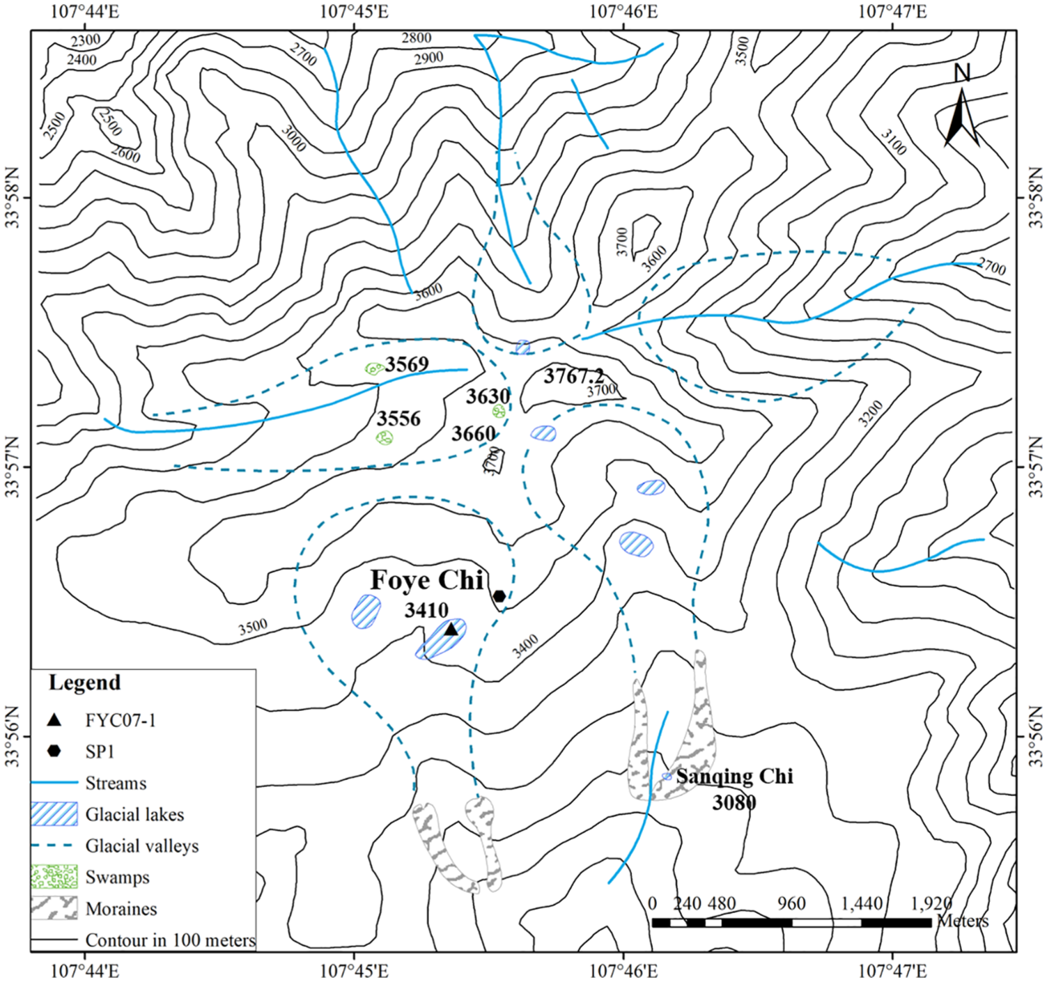
Foye Chi (lake), sampling location of a sediment sequence (FYC07-1) in it and of a soil profile (SP1) around it, and Sanqing Chi (lake) (Wang et al., 2016) with several other alpine and sub-alpine lakes or swamps on the Taibai Mountain.
Foye Chi (meaning ‘Buddha Pond’ in Chinese) (3410 m a.s.l.) is one of these alpine and sub-alpine lakes and the only one near the present timber line on the Mountain (Figures 1–3). We have previously displayed a 2300 year’s record of environmental changes based upon AMS14C dating, magnetism measurements and analyses of other proxies on a sediment sequence recovered from this alpine lake (Wang et al., 2010). The last 6000 years is of particular importance to the understanding of the Earth system since it is the most recent part of human history when a number of centennial-scale climatic events had taken place (Wanner et al., 2008). Therefore, it is necessary to explore environmental changes happening over this period. We have conducted measurements of mineral magnetism and analyses of other proxies (pollen, particle size, TOC, TN and δ15Norg) on another sediment sequence from Foye Chi. Magnetism measurements have been also performed on surface sediments collected from the lake, soils and rock debris collected in its catchment and surface soils sampled at different elevations on the southern slope of the Taibai Mountain. In addition, pollen analysis has been done for the surface-sediment sample from Foye Chi. Variations in mineral magnetism of the sediment sequence have revealed environmental changes occurring over the last 5520 years with aid of the other data, which has thus extended the existing 2300 year’s record. The reconstructed environmental changes have been compared with and related to centennial-scale variability of EASM and EAWM. This study is presented in this paper.
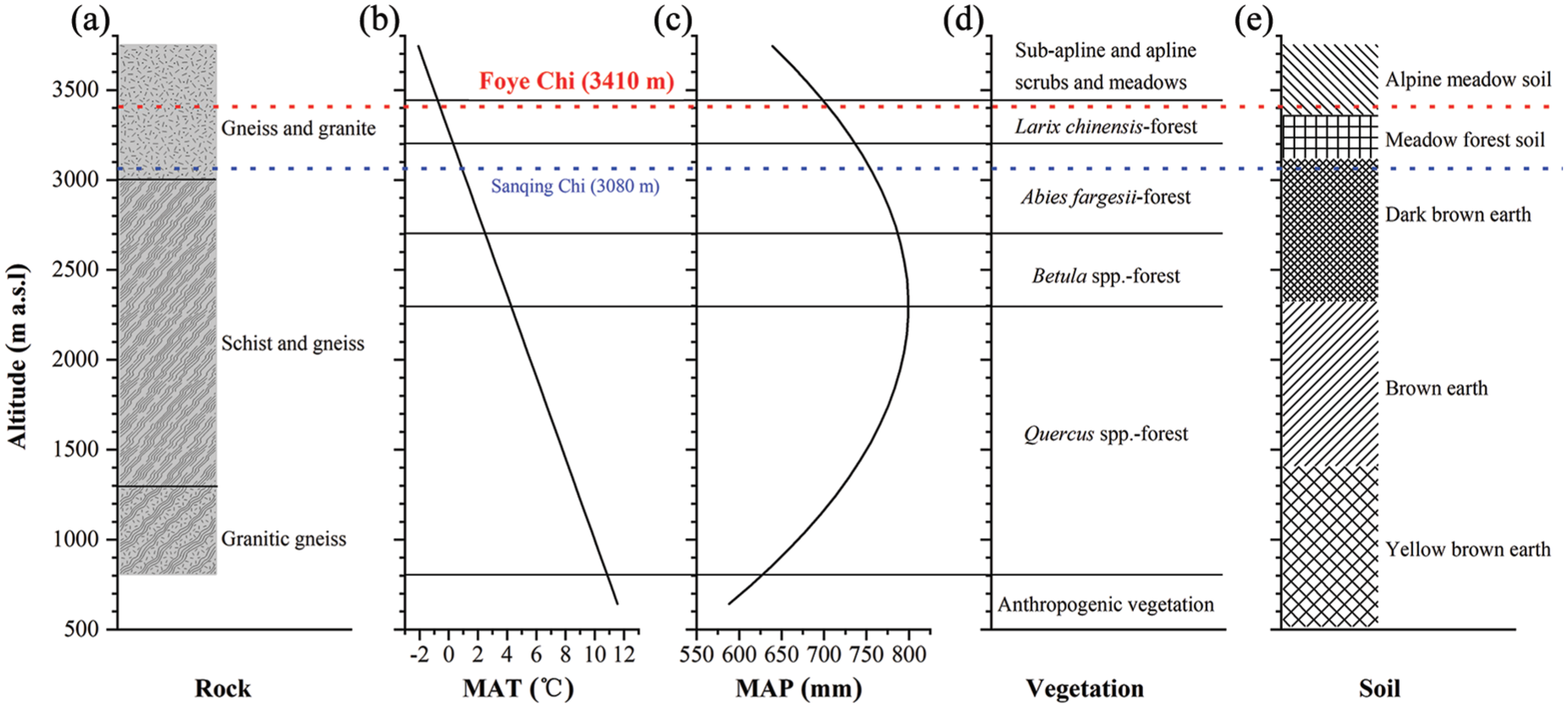
Altitudinal variability of rocks, temperature, precipitation, vegetation and soils on the Taibai Mountain and altitudes of Foye Chi (the study site) and Sanqing Chi (Wang et al., 2016). (a) Rocks distributed at different altitudes of the slopes of the Taibai Mountain (Lei et al., 2001; Qiu et al., 2016). (b) Changes in mean annual temperature (MAT) with altitudes on the southern slope of the Taibai Mountain (Liu et al., 2002; Wang et al., 2010). (c) Changes in mean annual precipitation (MAP) with altitudes on the southern slope of the Taibai Mountain (Liu et al., 2002; Wang et al., 2010). (d) Changes in vegetation with altitudes on the southern slope of the Taibai Mountain (Liu et al., 2002). (e) Soils exposed at different altitudes of the southern slope of the Taibai Mountain (Li and An, 1987).
Study area
The Taibai Mountain (33°41’–34°10’N, 107°19’–107°58’E, 3767 m a.s.l.) is the highest part of the Qinling Mountain Range (33°–34°30’N, 107°111’E) and located in central east China (Figure 1). The Chinese Loess Plateau lies in the north of the Mountain Range, while the Mu Us Desert and several other deserts lie even further north and northwest (Figure 1).
The Mountain is composed mainly of granitic intrusions formed in the Yenshan movement that took place during the Jurassic and Cretaceous. Cenozoic block-uplifts largely account for formation of this mountain. The granites and other older rocks have been, to varying degrees, altered by metamorphism in a few tectonic movements and magmatic activities. Therefore, there are also metamorphic rocks arisen. The altitudes of 800–1300 m a.s.l. of the Mountain are occupied by granitic gneiss, while those of 1300–3000 m a.s.l. by schist and gneiss (Figure 3a) (Lei et al., 2001; Qiu et al., 2016). Further upwards, gneiss and granite occur at the elevations of 3000–3767 m a.s.l. (Figure 3a).
With the lapse rates of temperature and precipitation proposed by Fu (1983), the mean annual temperature and precipitation at different elevations were calculated with 30 years’ records (1967–1997) from 12 meteorological stations around this mountain and at its low altitudes (Figure 3b and c) (Liu et al., 2002; Wang et al., 2010). Mean annual temperature (MAT) increases with altitudes on the southern slope of the Mountain (Figure 3b). Mean annual precipitation (MAP) increases with altitudes <2300 m a.s.l. and turns to decrease with altitudes >2300 m a.s.l. (Figure 3c). In other words, the highest precipitation occur around 2300 m. a.s.l. on the southern slope of the Mountain.
Located at the transition between the subtropical and warm temperate climate zones, the southern slope of <780 m a.s.l. of the Taibai Mountain is covered by mixed evergreen-deciduous broadleaved forest. However, the natural vegetation has been significantly modified in places on the lower slopes (Figure 3d). With the altitudinal variations in climate conditions, vegetation has also changed with altitudes on the southern slope of the Mountain (Figure 3d). From 780 m a.s.l. upwards, Quercus spp.-forest (780–2300 m a.s.l.), Betula spp.-forest (2300–2730 m a.s.l.), Abies fargesii-forest (2730–3200 m a.s.l.) and Larix chinensis-forest (3200–3400 m a.s.l.) occur successively with increasing elevation (Figure 3d). Above 3400 m a.s.l., alpine scrubs and meadows dominate (Figure 3d). The modern timberline lies at ~3400 m a.s.l. (Figure 3d) (Liu et al., 2002).
Soils have varied with elevations on the southern slope of the Mountain as well. Yellow brown earth (0–1400 m a.s.l.), brown earth (1400–2300 m a.s.l.), dark brown earth (2300–3100 m a.s.l.), meadow forest soil (3100–3350 m a.s.l.) and alpine meadow soil (3350–3767 m a.s.l.) are exposed with the increase of altitudes (Figure 3e) (Li and An, 1987).
Foye Chi (33°57’N, 107°44’E; 3410 m a.s.l.) is a cirque, 500–1000 m wide and 1000–1500 m long, near the lower limit of the present-day timberline on the southern slope of the Taibai Mountain (Figures 2 and 3). Water has collected in its deep parts and the small lake has thus formed (e.g. Ma and He, 1988; Rost, 1994; Xia, 1990). So this small depression has long been called ‘chi’ which means pond or small lake in Chinese. There are no records regarding surface area and depth for Foye Chi since this small lake has never been gauged. According to a ‘spoken history’ given by a senior priest and his predecessors living in a Taoist temple at ~3350 m a.s.l. of the southern slope of the Mountain, this pond has never desiccated during at least the last 300 years. The water surface area was estimated as ~33,400 m2 and water depth as 50 cm in July and August 1997 when field work was done in and around this pond. When re-visited in July and August 2007, 2012 and 2013, the lake floor was covered by several centimetres of water somewhere. However, even in 2008, Foye Chi has been still listed as one of the ‘glacial lakes’, most of which are filled with water today on the Mountain (Fu, 2008).
The catchment of Foye Chi, with an area of ~1.5 km2 and average slope is 19.84°, is largely underlain by granite. Mean annual temperature is estimated as −0.7°C and mean annual precipitation as 710 mm at 3410 m a.s.l. for the catchment (Figure 3b and c). Alpine scrubs and meadows occupy the catchment (Figure 3d). Near the lower edge of the cirque Larix chinensis-forest is present, which represents the timber line (Figure 3d) (Liu et al., 2002). Dark brown or light yellow brown alpine meadow soils have developed on the granitic debris and distributed among the exposed bedrocks and huge fragments. Thickness of these soils is usually 10–30 cm. On very gentle parts of the slopes, the soil layers are thicker than 30 cm and even as thick as 50–60 cm. As shown by chemical characteristics of a soil profile sampled at 3480 m a.s.l. of the northwest slope of the watershed (Li and An, 1987), the alpine meadow soils have fairly well developed within the depth of 6 cm (Figure 4).

Chemical characteristics of a profile of alpine meadow soil sampled at 3480 m a.s.l. of the southern slope of the Taibai Mountain (based on data of Li and An (1987)).
There are no residents permanently living at the high-altitude reaches of the southern slope of the Mountain except several priests living during summers in two Taoist temples at ~3350 m a.s.l. and ~3116 m a.s.l., respectively. Furthermore, no big wild animals have been found at these reaches. So, depositions in Foye Chi have been hardly disturbed.
Material and methods
Sampling and sub-sampling
A 70–cm deep pit was excavated on the desiccated floor of Foye Chi (Figure 2). With aluminum boxes of 40 cm in length, sediments were sampled from the wall of this pit and a 70-cm-long sediment sequence, referred to as ‘FYC07-1’, was thus obtained. One surface-sediment sample (BT) was collected from the inundated part of the lake floor.
A 60-cm-deep soil profile (SP1) was sampled with 5-cm interval at 3543 m a.s.l. on the eastern slope of the lake’s catchment (Figure 2) and 12 soil samples were thus obtained from this profile. Two rock debris samples (D1 and D2) and one surface-soil sample (BT (P)) were collected in the catchment. In addition, 33 surface-soil samples were collected at elevations of 600–3767 m a.s.l. of the southern slope of the Mountain. All the aforementioned ‘surface soil’ samples were taken from the depth of 0–5 cm.
Sediments of the uppermost part (0–9 cm) of FYC07-1 have shrunk due to drying and dewatering after sampled and stored at room temperature for 6 years (2007–2012). Hence, no specimens were sub-sampled from this part of the sequence. Totally 56 sediment specimens were collected from the remaining sections (9–70 cm) of FYC07-1.
There is no evidence on sedimentation discontinuities or desiccations in FYC07-1. The basal part (69.5–36.5 cm) of this sequence is mainly composed of brown silts, while the middle one (36.5–26.5 cm) consists of light grey clays (Figure 5). The upper portion (26.5–14.5 cm) is composed of light yellow silty clays and topped by light grey clays of 5 cm (14.5–9.5 cm) (Figure 5).

A chronological model and lithology of FYC07-1, the sediment sequence sampled from Foye Chi. Open circles represent the calibrated median-probability age plotted with the 2σ age range.
AMS14C dating
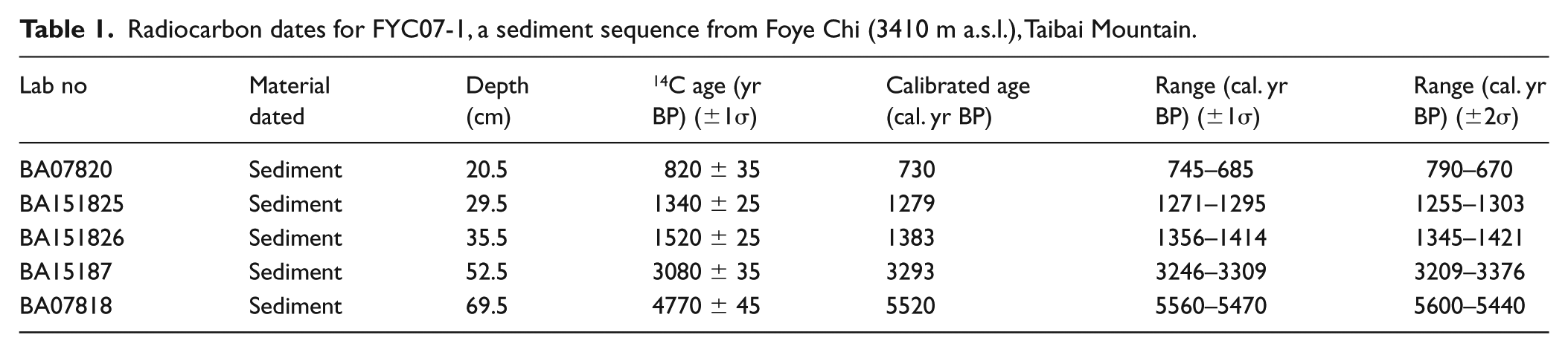
Specimens from five levels of FYC07 were chosen for AMS14C dating (Table 1). Since no macrofossils were found in them, bulk sediments were used for dating. The dating was undertaken at the AMS Laboratory, Peking University, Beijing, China.
Radiocarbon dates for FYC07-1, a sediment sequence from Foye Chi (3410 m a.s.l.), Taibai Mountain.
Measurements of mineral magnetism
The approach of mineral magnetism has been proved very effective in reconstructing palaeoenvironments (e.g. Chen et al., 2013; Liu et al., 2011; Oldfield et al., 2015; Tang et al., 2015). Measurements of mineral magnetism were performed on the 56 samples from the sediment sequence, one surface-sediment sample, 12 soil-profile samples, two rock debris, one catchment surface-soil and 33 non-catchment surface-soil samples.
Mineral magnetism of bulk sediments, soils and debris were measured. The materials were air-dried at room temperature and gently ground. Then they were packed into the sample boxes of 2 cm × 2 cm × 2 cm for measurements.
Low- and high-frequency magnetic susceptibility (χlf and χhf) were measured with a Bartington MS2 System at 0.46 kHz and 4.6 kHz, respectively. Anhysteretic remanent magnetizations (ARM) were induced with a peak AF field of 100 mT and DC field of 0.04 mT using a Molspin AF demagnetizer with ARM attachment. Isothermal remanent magnetizations (IRM) at field intensity of 20 mT, 300 mT and 1000 mT (IRM20mT, IRM300mT and IRM1000mT) were induced with a Molspin pulse magnetizer. IRM1000mT was referred to as ‘saturated isothermal remanent magnetization (SIRM)’ hereafter. The ARM, IRM and SIRM were measured with a Molspin Minispin magnetometer.
Frequency-dependent susceptibility (χfd) was calculated as ‘χlf – χhf’, while its percentage (χfd%) as ‘[(χlf – χhf)/χlf] × 100%’. The susceptibility of ARM, χARM, was derived. Furthermore, a few ‘inter-parametric ratios’, χARM/χfd, χARM/χlf, χARM/SIRM, IRM20mT/ARM, IRM300mT/SIRM and SIRM/χlf were also calculated.
The basic interpretations of the parameters and ratios aforementioned have been given by some researchers (Colman et al., 2000; Dearing, 1999; Evans and Heller, 2003; Oldfield, 1991; Thompson and Oldfield, 1986; Walden et al., 2000). χlf reflects concentrations of ferrimagnetic minerals. χfd is a measure of concentrations of superparamagnetic (SP) (<0.02 µm) ferrimagnetic grains, while χfd% estimates relative proportion of the fine SP grains in total ferrimagnetic minerals. Both ARM and χARM are sensitive to presence of stable single domain (SSD) (0.02–0.4 µm) ferrimagnetic grains and thus used to express concentrations of these relatively fine grains. IRM20mT and IRM300mT also reflect concentrations of ferrimagnetic minerals, while SIRM provides an estimation of total magnetic minerals including ferrimagnetic and anti-ferromagnetic ones. χARM/χfd describes relative proportions of SSD to SP ferrimagnetic grains. χARM/χlf is a measure of relative proportion of SSD ferrimagnetic grains in total ferrimagnetic minerals, while χARM/SIRM expresses relative proportion of these relatively fine SSD ferrimagnetic grains in assemblages of all magnetic minerals. IRM20mT/ARM may indicate grain size of magnetic minerals. High values of IRM20mT/ARM (>50) suggest dominance of multi-domain (MD) or coarser ferrimagnetic grains, while lower values of this ratio (<10) imply dominance of SSD or relatively fine ones. IRM300mT/SIRM is an indicator of proportion of ferrimagnetic minerals relative to anti-ferromagnetic ones in assemblages of magnetic minerals. Higher IRM300mT/SIRM values point to higher proportions of ferrimagnetic minerals and lower proportions of anti-ferromagnetic ones and vice versa. SIRM/χlf is sensitive to fine ferrimagnetic grains and particularly authigenic greigite (Fe3 S4) in magnetic assemblages dominated by ferrimagnets.
Pollen analysis
Pollen analysis was performed for the 56 sediment samples from FYC07-1 and surface-sediment sample (BT). A tablet of Lycopodium spores (about 27,637 grains) was added to each of the samples to obtain pollen concentrations. Pollen was extracted by treating the samples with acid and alkali and then with heavy liquid (Moore et al., 1991). Pollen taxa were identified under an Olympus optical microscope at 400× magnification, and more than 600 pollen grains were counted for each sample.
Particle size analysis
The method of particle size analysis has been widely used for lake sediments to explore palaeoenvironmental implications of them (e.g. Zhang et al., 2011). For all the 56 sediment specimens, particle size analysis has been performed with a Malvern Mastersizer 2000. The sediments used for particle size analysis were pre-treated with hydrogen peroxide (H2O2) to remove organic matter, HCl to remove carbonates and with sodium hexametaphosphate ((NaPO3)6) to facilitate dispersion. These samples were treated on an ultrasonic vibrator for 30 s. Then the analysis was made in the apparatus.
TOC and TN analysis
Analysis of TOC and TN has been made for all the 56 sediment sub-samples from FYC07-1 with a Vario MICRO CUBE elemental analyser. The sediments were treated with hydrochloric acid (HCl) to remove carbonates. For each sample, 10 mg sediment was wrapped in the tinfoil, added combustion improver, and then sealed for analysing in the apparatus. The %C and %N values of the carbonate-free samples were determined by elemental analysis of the sediment residues. TOC content and C/N ratio for the original specimens containing carbonates were then calculated.
δ15Norg analysis
The 56 sediment samples for δ15 Norg analysis were de-carbonated with excess of HCl. The analysis was performed with a Thermo Finnigan FlashEA 1112HT elemental analyser coupled to a Thermo Finnigan MAT253 mass spectrometer in the Key Laboratory of Groundwater Science and Engineering, Ministry of Natural Resources of China. USGS 40, which has certified δ15N of −4.5‰, was used as the working standard. δ15Norg values are given with respect to N2-Air. Analytical precision is within ±0.04‰.
Results
Chronology
The results of AMS14C dating of FYC07 are presented in Table 1.
These dates were calibrated to calendar years before present (cal. yr BP) using the OxCal v 3.10 programme with IntCal04 calibration data set. A chronological model was developed with the five dates by assuming constant accumulation rates between adjacent dated depths (Figure 5). With this model, the depths of the sediment sequence were transformed to ages (Figures 6, 7 and 8).
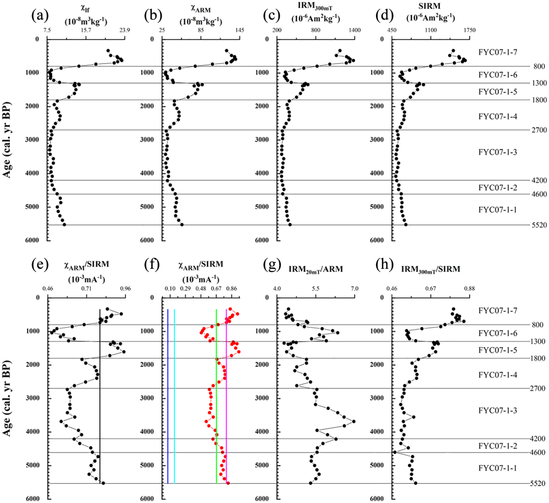
Temporal variations in mineral magnetism of FYC07-1 (see text for further explanation). In (e), the vertical line denotes the χARM/SIRM value of BT (a surface-sediment sample from Foye Chi). In (f), the red curve denotes the χARM/SIRM values of FYC07-1 while the pink, green, light blue and dark blue line denotes the χARM/SIRM value of BT (a surface-sediment sample from Foye Chi), BT (P) (a surface-soil sample from the catchment of Foye Chi), D1 (a debris sample from the catchment of Foye Chi) and D2 (another debris sample from the catchment of Foye Chi).
Mineral magnetism
Temporal variations of several selected concentration-dependent parameters (χlf, χARM, IRM300mT and SIRM) and inter-parametric ratios (χARM/SIRM, IRM20mT/ARM and IRM300mT/SIRM) of FYC07-1 were displayed in Figure 6.
Variations in mineral magnetism of sediments deposited in lakes are not necessarily caused by changes in weathering, pedogenesis and erosion taking place in catchments and post-depositional changes (i.e. dissolution of iron minerals, genesis of bacterial magnetosomes and authigenic greigite) may happen and also alter more or less magnetic characteristics of these sediments in water bodies (e.g. Dearing, 1999; Hu et al., 2002; Pan et al., 2005). Before interpreting variations in mineral magnetism of lake sediments in terms of changes in catchment processes, possible impacts of these changes must be considered first.
Dissolution eliminates fine and relatively fine ferrimagnetic grains, leaving coarse or relatively coarse ferrimagnets unaltered when depositional rates are moderately low and reductive conditions prevail in lakes (e.g. Dearing, 1999; Snowball, 1993). Typically, sediments significantly influenced by such reductive dissolution have very low or nearly ‘zero’ concentrations of SP grains (e.g. Dearing, 1999; Snowball, 1993). χfd% values <2% suggest absence of the SP grains, while χfd% values of 2–10% indicate an admixture of SP grains and coarser ones (Dearing, 1999). Therefore, χfd% has been often used to assess impacts of dissolution on magnetism of lake sediments.
χfd% (not shown in Figure 6) is lower than 2% only at three levels (corresponding to 4342, 3293 and 916 cal. yr BP) of FYC07-1, 0.49%, 1.08% and 1.76%, suggesting rarity or absence of SP grains. At other levels of this sediment sequence, χfd% varies from 2.02 to 18.05 with an average of 6.95%, implying significant presence of SP ones. Sediment particles are fine or relatively fine at the corresponding levels as shown by the mean particle size data (Figure 8e). Therefore, deposition rates may be fairly low and reductive conditions prevail in the pond when sediments were being accumulated at the levels. As a result, some SP grains may have been removed by reductive dissolution at the levels. There are no similar sub-ordinate lows in χARM and χARM/SIRM (Figure 6b, e and f). So, the dissolution may have not significantly removed SSD grains at the three levels. In addition, there are no corresponding lows in χlf, IRM300mT, SIRM and IRM300mT/SIRM (Figure 6a, c, d and h) and highs in IRM20mT/ARM (Figure 6g). Thus, impacts of the dissolution are still relatively slight even at the three levels. χARM, χARM/SIRM and mean particle size are remarkably low in the interval of 1300–800 or 1400–1000 cal. yr BP, implying possible dissolution of SSD grains (Figures 6b, e, f and 8e). However, χfd% is not low and instead has increased in this interval. Dissolution usually eliminates the finest SP grains first. It is difficult to imagine that SSD grains are considerably dissolved and finer SP grains remain untouched when dissolution takes place. Thus, the rarity of SSD grains in this interval cannot be attributed to dissolution.
In FYC07-1, χARM/χlf fluctuates from 3.49 to 6.33 (not shown in Figure 6) with an average of 4.90 and χARM/χfd from 0.02 to 0.90 × 10³ (not shown in Figure 6) with an average of 0.11 × 10³, still lower than 40 and 1 × 10³, the threshold values of the two ratios indicative of presence of bacterial magnetosomes in lake sediments (Oldfield, 1994). In other words, there is no evidence for genesis of bacterial magnetosomes in this sediment sequence.
SIRM/χlf (not presented in Figure 6) changes within the range of 5.91–8.71 with a mean of 6.74 × 10³ A m−1 in FYC07-1, much lower than 40 × 103 A m−1, the crucial value of this ratio suggesting significant presence of authigenic iron sulphide or greigite (Fe3 S4) (Peck et al., 2004; Snowball, 1991). So, contributions from diagenetic greigite to magnetic characteristics are generally insignificant throughout the whole sequence. SIRM/χlf and χfd% are higher in the interval of 1300–800 cal yr BP, suggesting more authigenic greigites formed as SP grains in this interval than in the intervening ones. Nevertheless, both χARM and χARM/SIRM are very low in the interval (Figure 6b, e and f). Therefore, contributions from authigenic SSD grains, if there are any, are still minimal even in this interval. χfd% and particularly χARM and χARM/SIRM (Figure 6b, e and f) have obviously increased in the interval of 2700–1800 cal. yr BP while SIRM/χlf has only slightly increased or is almost the same as in the underlain interval. So the increases of SP and SSD grains are not entirely resulted from additions of authigenic greigites in this interval. Increases of detrital input must have at least partly contributed the increases of SP and SSD grains. Therefore, the variations in χARM and χARM/SIRM in FYC07-1 are still basically signals of changes in input of allogenic SSD ferrimagnets though probably slightly overprinted by authigenic greigites.
Variations of the selected parameters and ratios with depth in the soil profile (SP1) were presented in Figure 9. χlf, IRM300mT, SIRM and IRM20mT/ARM increases with depth in SP1 (Figure 9a, c, d and g). Such variations in mineral magnetism may suggest that relatively coarse, primary ferrimagnets are generally sparse at the upper levels strongly influenced by pedogenesis and are abundant at deeper levels less pedogenetically affected. χARM and χARM/SIRM decrease with depth in SP1 (Figure 9b, e and f), hinting at abundance of relatively fine, secondary SSD ferrimagnets due to relatively strong pedogenesis at the upper levels and scarcity of the pedogenetically originated ferrimagnetic grains in the deeper levels. Variations in χfd% with depth (not shown in Figure 9) are generally similar to those in χARM/SIRM in SP1. Nevertheless, χfd% values are particularly high in the top 10 cm of the soil profile. The Taibai Mountain is situated at the south of the Chinese Loess Plateau and Mu Us Desert (Figure 1). The topsoil at the high elevations of the Mountain may have been mixed with dusts blown by north or northwest winds from the Plateau, the Desert or other deserts lying further northwest. The extraordinarily high χfd% in the uppermost 10 cm of the soil profile is probably attributable to additions of SP grains associated with aeolian materials since dusts have higher χfd% (e.g. Oldfield et al., 1985).
IRM300mT/SIRM is somewhat higher at the most superficial level and decreases with depth but increases again in the deepest levels (Figure 9h). The downwards changes in IRM300mT/SIRM in SP1 indicate that relative proportion of ferrimagnetic minerals is high due to abundance of the pedogenic SSD ferrimagnets in the superficial levels, decreases with the decrease of the relatively fine SSD ferrimagnetic grains with depth and has again increased owing to abundance of relatively coarse, primary ferrimagnets in the basal levels of this soil profile.
The same parameters and ratios of the two debris samples (D1 and D2), surface-soil sample (BT (P)) and surface-sediment sample (BT) were displayed in Table 2. In particular, χARM/SIRM of D1, D1, BT (P) and BT was also presented in Figures 6f and 9f in comparison with the same ratio of the sediment sequence (FYC07-1) and soil profile (SP1), respectively.
Magnetic parameters and inter-parametric ratios of rock debris, surface-soil and surface-sediment samples collected from the catchment of Foye Chi and the lake itself, the Taibai Mountain, central east China.
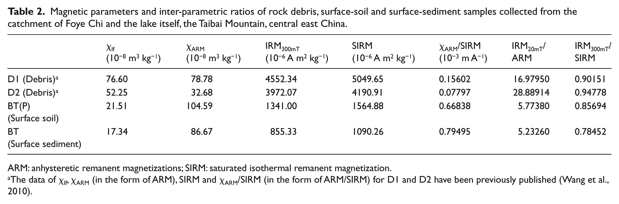
The data of χlf, χARM (in the form of ARM), SIRM and χARM/SIRM (in the form of ARM/SIRM) for D1 and D2 have been previously published (Wang et al., 2010).
χARM and χARM/SIRM of the surface-soil sample are higher than those of the two debris ones, indicating more abundant SSD ferrimagnets in the surface soils than in the debris due to varying degrees of soil-forming processes. In contrast, χlf, IRM300mT, SIRM, IRM20mT/ARM and IRM300mT/SIRM of the debris samples are higher than those of the surface-soil one, indicative of dominance of coarsely grained primary ferrimagnetic minerals in the less weathered debris. The surface-soil sample has higher χlf, χARM, IRM300mT, SIRM and IRM300mT/SIRM than the surface-sediment one.
We suppose that the surface sediments are roughly contemporary with the surface soils. However, the surface-sediment sample has higher χARM/SIRM and lower IRM20mT/ARM than the surface-soil one (Table 2). So the proportion of the relatively fine SSD ferrimagnets is higher in the surface sediments than in the contemporary surface soils or the relatively fine SSD ferrimagnetic grains have actually enriched in the surface sediments.
The χfd% value of the catchment surface-soil sample is higher than those of the two debris samples but lower than the one of the surface-sediment sample
Variations of mineral magnetism of the 33 non-catchment surface-soil samples with altitudes were shown in Figure 10. Though somehow fluctuating, χlf, IRM300mT and SIRM decrease in general with elevations at 600–3600 m a.s.l. (Figure 10a, c and d). Such changes may suggest that secondary ferrimagnetic minerals have decreased due to declining pedogenesis with increasing altitudes. However, the three concentration-dependent parameters turn to increase at elevations >3600 m a.s.l. (Figure 10a, c and d), which are probably due to survivals of more primary ferrimagnetic minerals in the surface soils because soil-forming processes are declining with the increasing altitudes. χARM has throughout decreased with increasing elevations (Figure 10b), confirming the decrease of secondary ferrimagnetic minerals with lowering degrees of soil-forming processes since SSD ferrimagnets are usually pedogenetically originated. Variations in χARM/SIRM, IRM20mT/ARM and IRM300mT/SIRM in the non-catchment surface soils with altitudes are much more complicated (Figure 10e, f and g), which may have also somehow reflected influences of temperature, precipitation and/or their inter-actions varying with elevations. Nevertheless, at the elevations of >3200 m a.s.l., χARM/SIRM decreases and both IRM20mT/ARM and IRM300mT/SIRM increase with altitudes (Figure 10e, f and g). Such variations in the three inter-parametric ratios suggest that the proportion of the relatively fine, secondary SSD ferrimagnets decreases while coarsely grained, primary ferrimagnetic minerals increase with increasing altitudes without exception at the elevations >3200 m a.s.l. Variations in χfd% (not presented in Figure 10) of these non-catchment surface-soil samples with altitudes are similar to those in χARM/SIRM. In general, χfd% has still decreased with elevation at the altitudes of >3200 m a.s.l. However, χfd% values of two samples have deviated remarkably from the overall trend of variations of this parameter with altitudes. The χfd% value of a sample from 3200 m a.s.l. is considerably lower than those of several samples from higher elevations, while the one of another sample from 3685 m a.s.l. is much higher than those of the samples from lower altitudes. It has been found that dusts have higher χfd% (Oldfield et al., 1985). So, once again, such deviations of the χfd% values can be tentatively ascribed to possible mixture of wind-blown SP grains associated with dusts from the Chinese Loess Plateau, Mu Us Desert or other deserts located at the north or northwest of the Mountain (Figure 1).
Variations particularly in the inter-parametric ratios of the catchment surface-soil samples versus debris samples (Table 2), soil-profile samples with depth (Figure 9) and non-catchment surface-soil samples with altitudes of >3200 m (Figure 10) may have actually reflected differences in pedogenic degrees. Soils may develop or change their own properties in response to climatic variability quickly (e.g. Maher and Thompson, 1999). It has been found that a 31 cm A horizon with organic carbon content reaching 2.6% has developed during only the last 100 years (Hallberg et al., 1978). Thus, climatic changes of 102 years’ scale could be recorded in physical, chemical and biological characteristics of soils and particularly of topsoil. For example, variations in stable isotopic carbon of soil organic matter have indicated the climatic events of Medieval Warm Period (MWP) and Little Ice Age (LIA), lasting only for ~470 and 580 years, respectively (Driese et al., 2004). Therefore, we assume that response of pedogenic magnetism particularly in the topsoil (0–5 cm) to such relatively short climate changes is also fast enough to record them in the high altitudes of the Mountain. So, the variations in soil magnetism are helpful for interpreting those in the same magnetic variables of the sediments in terms of climatic and environmental changes since variations in mineral magnetism of lake sediments may reflect changes in maturing of soils (e.g. Guerrero et al., 2000).
Higher values of χARM/SIRM in the sediments are likely to suggest higher proportions of the secondary SSD ferrimagnets in the soils from which the sediments are derived, higher degrees of pedogenic processes and thus warmer and wetter climates. In contrast, increasing IRM20mT/ARM in the sediments may imply decreasing SSD ferrimagnets in the soils, lowering degrees of pedogenic processes and cooler and drier conditions around the lake. As implied by the vertical variations in IRM300mT/SIRM in the soil profile (Figure 9h), interpretations of this ratio in the sediments are probably more difficult. On one hand, higher IRM300mT/SIRM of the sediments may be due to increase of the relatively fine, secondary ferrimagnets in the soils, enhanced pedogenic processes and thus warmer and wetter conditions around the lake. On the other hand, the increases in IRM300mT/SIRM of the sediments may be alternatively caused by increase of coarsely grained primary ferrimagnets in the soils, declining pedogenic processes and thus cooler and drier surroundings.
The relative proportions of SSD ferrimagnetic grains in the sediments are higher than those of the soils from which they are derived (Table 2). Nevertheless, χARM/SIRM of the sediments can still provide rough estimations of proportions of these secondary ferrimagnets in their contemporary soils and hence an inference on pedogenic degrees and climatic conditions. The χARM/SIRM value of the surface-sediment sample (BT) is higher than the one of the surface-soil sample (BT (P)) (Table 2). The relative enrichment of the fine SSD ferrimagnets in the surface sediments is likely resulted from what may have happened when the soil particles and magnetic grains were being transported towards the lake. Selective sorting associated with hydrodynamic or topographical conditions may have occurred. Hence, the relatively fine SSD grains would have more chances to be moved into the lake particularly when they were abundant on the slopes of the catchment. The ratio of the BT (P)’s χARM/SIRM to BT’s one is ~ 0.84, which is very close to ~0.86, the ratio of χARM/SIRM of a surface-soil sample to χARM/SIRM of a surface-sediment sample collected from Sanqing Chi, another small lake, and its catchment on the southern slope of the Taibai Mountain (Figures 2 and 3) (Wang et al., 2016). So, impacts of gradients and/or other topographical factors on grain or particle transportation are possibly similar since mean slopes of the two catchments are rather close each other (19.84° for the catchment of Foye Chi and 15.25° for the catchment of Sanqing Chi. Alternatively, such enrichment of the SSD grain may be partly caused by diagenetic authigenesis. The parts of the lake floors where the surface sediments were sampled have been at very low-level water or desiccated for the last decades. Authigenic greigites have been found usually formed on the lake- or reservoir-floors at shallow water (Peck et al., 2004; Reynolds et al., 1999). Hence, the higher proportions of SSD grains in the surface sediments are probably due to additions of authigenic greigites. Sanqing Chi is located at lower altitudes (3080 m a.s.l.) and thus warmer and wetter conditions (2°C and 750 mm) than Foye Chi (3410 m a.s.l., –0.71°C and 713.9 mm) (Figures 2 and 3). However, the values of this ratio for the two lakes are very close each other. Hence, we suppose that difference of the influences from authigenic greigite caused by fluctuations in temperature and precipitation within such a range is relatively slight on magnetism of the sediments deposited in Foye Chi. Furthermore, this ratio was probably oscillating only within the range of 0.84–0.86 when FYC07-1 was deposited in Foye Chi though climatic conditions varied then. Therefore, we have used an average (~0.85) to calculate the weighted χARM/SIRM values of the sediments of FYC07-1. The weighted χARM/SIRM values of the sediments may be closer to the ones of their contemporary soils in the catchment and particularly at the altitudes where the main sediments were derived or the ‘main sediment-contribution belt (MSCB)’ as we would call below.
During the past 6000 years, the timberline may have migrated 150–200 m upwards on the southern slope of the Taibai Mountain sometime when the optimal temperature and humidity occurred (Cheng et al., 2017). In other words, even during the optimum phase when it was the warmest and wettest, the climatic conditions around Foye Chi were not warmer and wetter than those at the altitude of ~3200 m on the southern slope of the Mountain nowadays. Thus, mineral magnetism of the surface soils on the altitudes >3200 m may provide clues for interpreting the variations in mineral magnetism of the sediment sequence in terms of environmental changes over the last ~6000 years. We referred the two non-catchment surface-soil samples collected at the altitudes of 3410–3200 m a.s.l. (3200 and 3305 m) to as ‘Well Developed Soils (WDS)’ and one non-catchment surface-soil sample collected at the altitudes of >3410 m a.s.l. (3498 m) and the catchment surface-soil sample (BT (P)) collected at 3460 m a.s.l. to as ‘Moderately Developed Soils’ (MDS). The four non-catchment surface-soil samples collected at the altitudes of >3600 m a.s.l. (3616, 3680, 3700 and 3758 m) are referred to as ‘Poorly Developed Soils (PDS)’. Scatter-plots of the χARM/SIRM or weighted χARM/SIRM versus IRM20mT/ARM were made for soils of the three categories (WDS, MDS and PDS) and the sediments (FYC07-1) to relate variations in the two inter-parametric ratios of the sediments to changes in pedogenetic degrees at the MSCB (Figure 11). Furthermore, a regression relation between χARM/SIRM of the nine surface-soil samples collected at the elevations >3200 m a.s.l. and their elevations (H) was developed (H = −688.59 × χARM/SIRM + 3887.97 (R2 = 0.88)). With the equation and weighted values of χARM/SIRM of FYC07-1, the altitudes at which the present climates are similar to the past ones for different periods when the sediments were derived were estimated (Figure 12).
Pollen composition
Selected results of pollen analysis of FYC07-1 are presented in Figure 7.
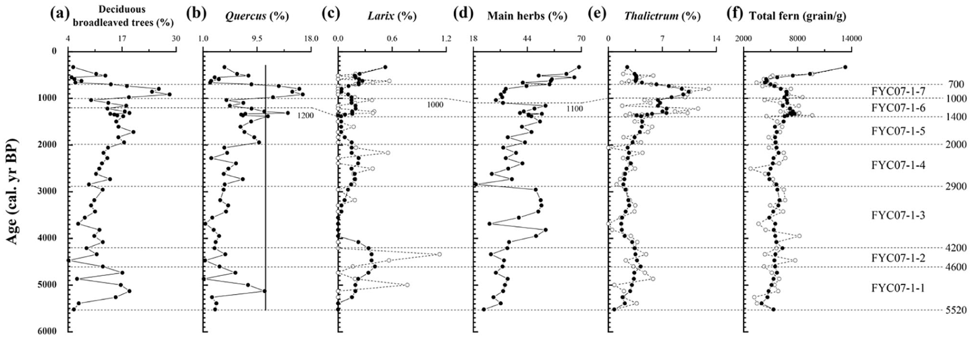
Temporal variations in pollen compositions of FYC07-1 (see text for further explanation). In (b), the vertical line denotes the Quercus percentage of BT (a surface-sediment sample from Foye Chi). In (c), (e) and (f), the open circles denote original values of the pollen or spore compositions and solid circles smoothed data using a 5-point Gaussian filter (Marchand and Marmet, 1983).
More than 30 families and genera of pollen were identified in FYC07-1. The major tree taxa are Pinus, Tsuga, Quercus, Betula, Juglans, Picea, Abies, Larix and Ulmus while Corylus, Salix, Ericaceae and Rosaceae predominate the shrub taxa. The dominant herb taxa include Cyperaceae, Artemisia, Polygonaceae, Chenopodiaceae, Ephedra, Ranunculaceae, Compositae, Gramineae and Labiateae. Fern spores include Polypodium, Monolites, Trilites, Botrychium and Selaginella.
Variations in pollen compositions of sediments from mountainous peat and lakes have been related to shifts of altitudinal vegetation belts and further to climate changes (Liew et al., 2006; Xiao et al., 2014). Pollen percentages of Quercus and other broadleaved trees are commonly used as indicators of warm and moist conditions (Jiménez-Moreno et al., 2013; Li et al., 2010; Zheng and Li, 2000). At present, Quercus is the main element of Quercus spp.-forest (780–2300 m a.s.l.) and Betula is the main element of Betula spp.-forest (2300–2730 m a.s.l.), which occur at relatively low altitudes of the Taibai Mountain (Figure 3d). Juglans and Ulmus also grow in Quercus spp.-forest. The percentages of the pollen of Quercus, Betula, Juglans and Ulmus (referred to as ‘deciduous broadleaved trees’) were summed and displayed with the pollen percentage of Quercus (Figure 7a and b). Therefore, abundant pollen grains of these deciduous broadleaved trees may indicate generally warm and wet conditions. Larix is the dominant element of Larix chinensis-forest, which is distributed at high altitudes (3200–3400 m a.s.l.) (Figure 3d). Therefore, increases in the percentage of Larix pollen, particularly with decreases of pollen percentage of deciduous broadleaved trees, are often ascribed to cool and arid conditions. The percentage of Larix pollen was thus presented (Figure 7c). Herbs grow at the alpine meadows at higher elevations (>3400 m a.s.l.) (Figure 3d) and increases in the pollen percentages of most of the herbs are thus related to even cooler and drier conditions. So, the pollen percentages of the herbs (except Ranunculaceae and Thalictrum) (referred to as ‘main herbs’) were summed and displayed (Figure 7d). Ranunculaceae and particularly Thalictrum are hygrophilous herbs. Therefore, the percentage of Thalictrum and the summed concentrations of all the fern spores were presented to indicate humid conditions (Figure 7e and f).
Assuming the transport rate of a pollen type is constant, the percentage of that pollen is related, at least in part, to the distance from the pollen source to the site of deposition. When climate becomes warmer and wetter, vegetation zones shift upwards and pollen of plants previously living at lower altitudes may occur or increase in sediments at higher elevations. Vegetation zones move downwards with changes towards cooler and drier conditions and the pollen of vegetation originally distributed at high elevations is likely to occur or increase in these lower-elevation sediments. Therefore, fluctuations in pollen percentages may indicate vertical movements of the vegetation zones and be related to changes in climate.
Pollen percentages of some plants in surface sediments have been used as references in interpreting changes in pollen percentages of older sediments and inferring past environments of the high altitudes of the Taibai Mountain (Liu et al., 2002; Wang et al., 2010). The percentages of Quercus pollen have been proved particularly useful and thus one of the surface-sediment sample (BT) was displayed (Figure 7b).
Particle size
Temporal variations in particle size of the sediment sequence were shown in Figure 8a–e.
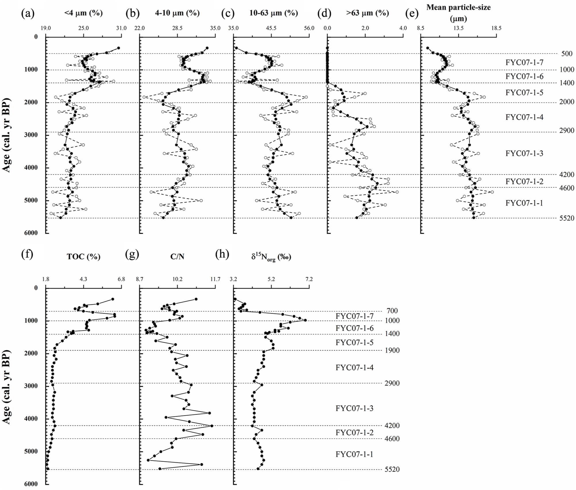
Temporal variations in particle size (a–e), TOC (f), C/N (g) and δ15Norg (h) of FYC07-1. In (a–e), the open circles denote original values of the particle size and solid circles smoothed data using a 5-point Gaussian filter (Marchand and Marmet, 1983).
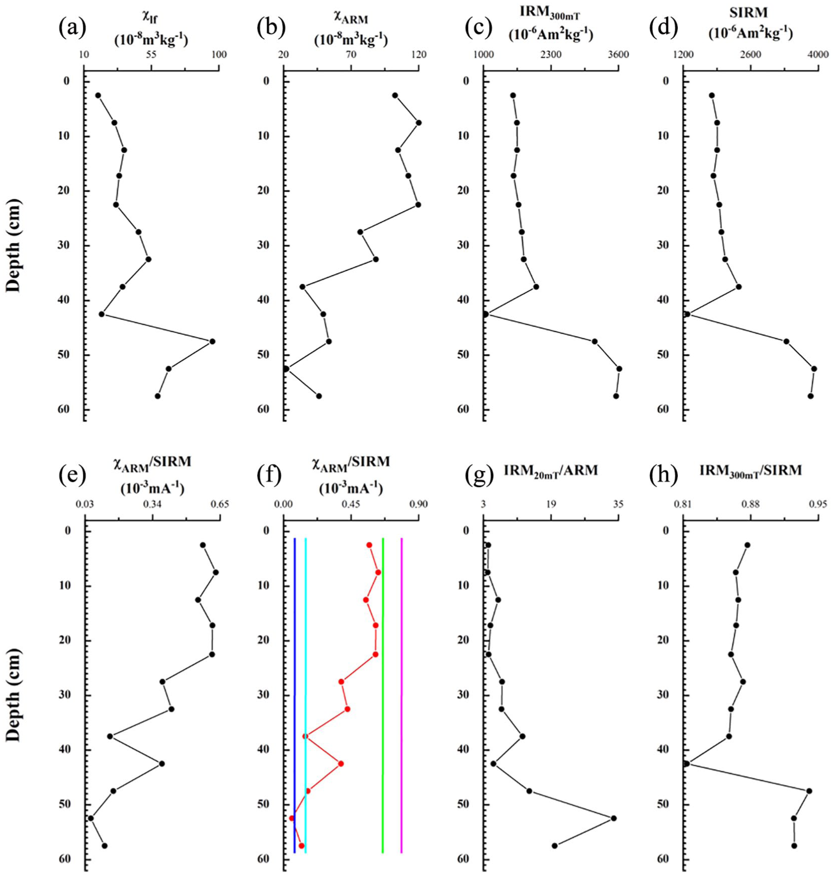
Variations in mineral magnetism with depth in SP1 (a soil profile sampled in the catchment of Foye Chi) (see text for further explanation). The data of χlf (a), χARM (b) (in the form of ARM), SIRM (d) and χARM/SIRM (in the form of ARM/SIRM) (e) have been previously published (Wang et al., 2010). In (f), the red curve denotes the χARM/SIRM values of SP1 while the pink, green, light blue and dark blue line denotes the χARM/SIRM value of BT (a surface-sediment sample from Foye Chi), BT (P) (a surface-soil sample from the catchment of Foye Chi), D1 (a debris sample from the catchment of Foye Chi) and D2 (another debris sample from the catchment of Foye Chi).

Variations in mineral magnetism of surface soils with altitudes on the southern slope of the Taibai Mountain (see text for further explanation).
Particles are generally coarse in the sediments deposited before 1400 cal. yr BP. However, particle size also increases moderately in the sediments deposited during 1000–500 cal. yr BP.
Variations in particle size of lake sediments have been usually ascribed to changes in intensity of erosion in catchments where the water bodies are located (Chen et al., 2004; Lanci et al., 1999; Schmidt et al., 2002). More coarse particles are transported into lakes and particle size of sediments increases when erosion intensifies in catchments. When erosion declines, the coarse particles moved into the water decrease and the sediments become finer in general. The changes in erosion intensity can be further related to those in precipitation and surface-runoff (Creer and Morris, 1996), i.e. higher precipitation and surface-runoff lead to more intense erosion and vice versa. On the other hand, particle size of lake sediments is likely influenced by weathering or pedogenesis in catchments, which can be also related to climates. When climate is warm and humid, weathering or pedogenesis is intense and soils are thus generally finer. So particles moved into the lake are correspondingly finer. The particles transported into the lake are relatively coarse during cold and dry period because pedogenesis has declined and soils and weathered debris are comparatively coarser.
Variations in the particle size throughout FYC07-1 are more likely the ‘net’ results of the two processes (erosion and pedogenesis) rather than caused by only single one.
TOC, C/N and δ15Norg
Temporal variations in TOC, C/N and δ13Norg were displayed in Figure 8f, g and h.
TOC fluctuates from 1.9% to 6.4% and C/N from 8.95 to 11.56.
The variations of C/N are negatively related to those of TOC in the sediments deposited before 1000 cal. yr BP but positively related to those in TOC in the sediments deposited after 1000 cal. yr BP. C/N is the highest in the interval of 4600–2900 cal. yr BP in which TOC is very low.
Higher TOC of lake sediments suggests higher organic matter contents and more abundant terrestrial plants around and/or aquatic organisms in lakes and is usually attributed to warm and/or wet conditions. Phytoplankton have low C/N ratio (commonly 4–10), whereas vascular land plants have C/N ratios of ⩾20 (Meyers and Lallier-Verges, 1999). Therefore, higher C/N implies relatively increased contributions from allochthonous (terrestrial) sources while lower C/N hints at relatively increased autochthonous (aquatic) contributions to sediment’s organic matter (e.g. Meyers and Lallier-Verges, 1999). The range of C/N of this sequence suggests that organic matter of these sediments is largely from aquatic sources though there are also minor contributions from terrestrial plants. However, C/N commonly decreases with depth in sediments deposited in oligotrophic lakes as organic matter degrades (Meyers and Lallier-Verges, 1999). Anaerobic utilization of organic carbon yields CO2 and CH4, which escape from the sediments as TOC concentrations decrease. Therefore, very low C/N accompanied by low TOC particularly in basal parts of such sediment sequences may be also due to degradation of organic matter.
δ15Norg fluctuates from 3.3‰ to 7.0‰. It is low or relatively high in the sediments deposited before 1900 cal. yr BP. Nevertheless, δ15Norg values begin to increase upwards from the level of 1900 cal. yr BP and hit the highest in the interval of 1000–700 cal. yr BP. However, it drops to the lowest in the sediments accumulated since 700 cal. yr BP.
Higher δ15Norg of lake sediments have been interpreted as the result of an increased primary productivity or increased aquatic organisms and hence warmer and/or wetter conditions, while lower values of δ15Norg have been ascribed to colder and/or drier conditions (e.g. Meyers and Lallier-Verges, 1999; Parplies et al., 2008; Talbot et al., 2006).
Interpretation
Based on the variations in mineral magnetism, pollen composition, particle size, TOC, C/N and δ15Norg of FYC07-1, this sediment sequence was divided into seven units (Figures 6–8). Environmental conditions were reconstructed for each of the seven periods covered by these units.
FYC07-1-1 (5520–4600 cal. yr BP)
χlf, χARM, IRM300mT and SIRM are still relatively high, suggesting that ferrimagnetic minerals including SSD ferrimagnets and total magnetic minerals moved into the lake are still rather abundant. In other words, erosion was still relatively intensive in the catchment and rainfall/surface-runoff relatively abundant. χARM/SIRM is still relatively high, while IRM20mT/ARM is relatively low. Thus, the proportion of relatively fine SSD ferrimagnets in total magnetic minerals is still comparatively high and magnetic minerals in the sediments are still fine in general. Furthermore, secondary SSD grains were abundant in the catchment soils and the pedogenic processes were still strong. There were still contributions from the Well Developed Soils (WDS), though the sediments were mainly contributed by the Moderately Developed Soils (MDS) (Figure 11a). Therefore, there still existed the WDS at the altitudes from which the main sediments were derived (‘main sediment-contribution belt’ or ‘MSCB’) though the belt was probably largely occupied by the MDS. The χARM/SIRM values of the sediments of FYC07-1 are very close to the one of the surface-sediment sample (Figure 6e and f). As shown by the weighted χARM/SIRM, the climatic conditions at the lower limit of the MSCB were similar to those nowadays at 3410 m a.s.l., the altitude of the lake floor (Figure 12a). Therefore, the climatic conditions during this phase were probably similar to those at present. The conditions around the upper limit of the MSCB were somehow similar to those nowadays around the altitude of 3460 m a.s.l. (Figure 12a).
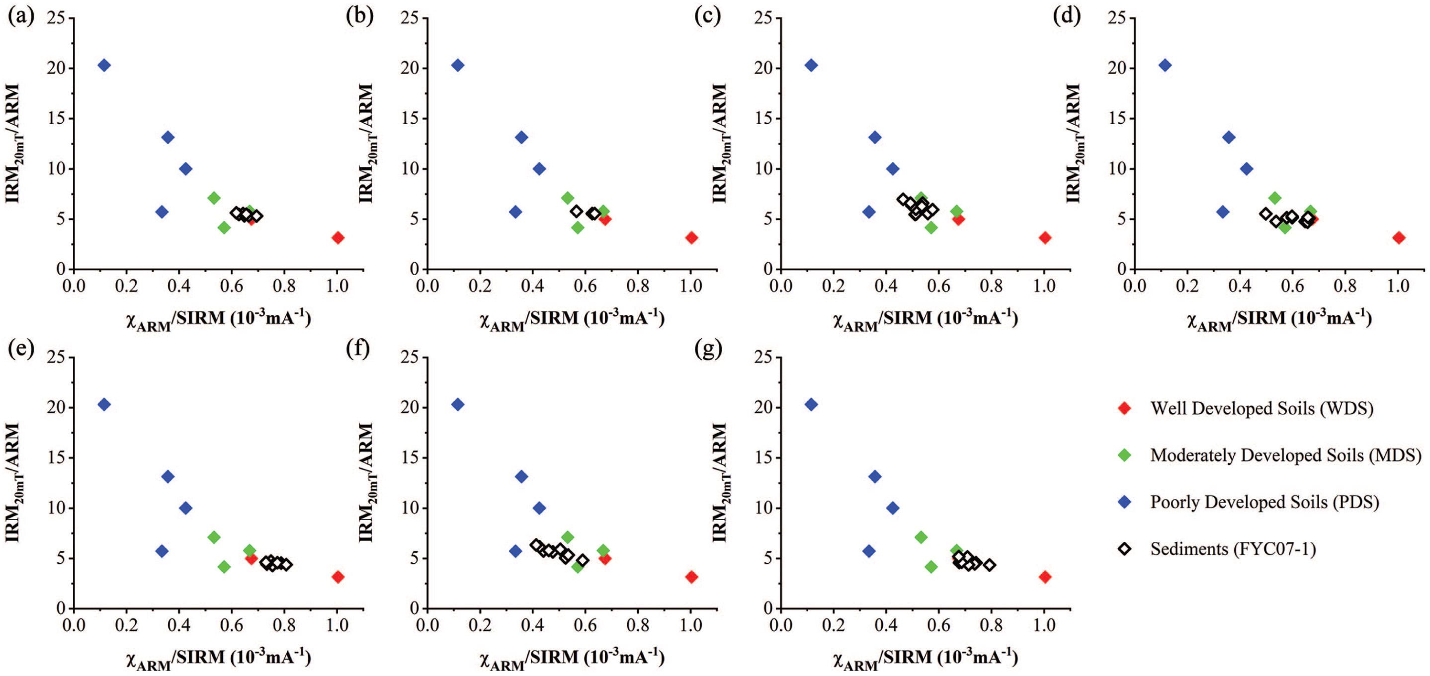
Scatter plots of the weighted χARM/SIRM values versus IRM20mT/ARM of different intervals of FYC07-1 with χARM/SIRM versus IRM20mT/ARM of surface soils of different pedogenic degrees. (a) FYC07-1-1 (5520–4600 cal. yr BP), (b) FYC07-1-2 (4600–4200 cal. yr BP), (c) FYC07-1-3 (4200–2700 cal. yr BP), (d) FYC07-1-4 (2700–1800 cal. yr BP), (e) FYC07-1-5 (1800–1300 cal. yr BP), (f) FYC07-1-6 (1300–800 cal. yr BP), (g) FYC07-1-7 (800–?cal. yr BP).
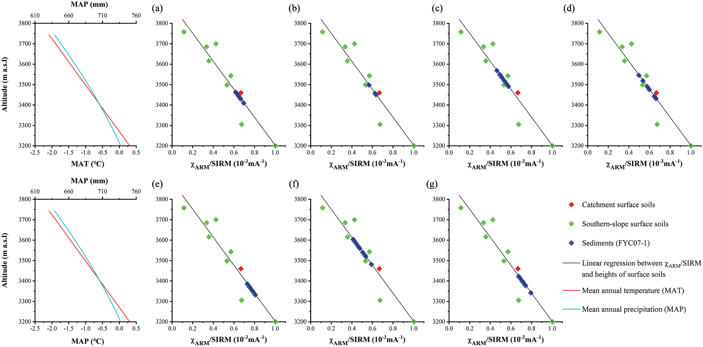
Weighted values of χARM/SIRM of different intervals of FYC07-1 with χARM/SIRM of surface soils on altitudes > 3200 m on the southern slope of the Taibai Mountain. The ‘altitudes’ of these sediments in comparison with variations in temperature and precipitation (Liu et al., 2002; Wang et al., 2010) may imply climatic conditions during the periods when these sediments were derived. (a) FYC07-1-1 (5520–4600 cal. yr BP), (b) FYC07-1-2 (4600–4200 cal. yr BP), (c) FYC07-1-3 (4200–2700 cal. yr BP), (d) FYC07-1-4 (2700–1800 cal. yr BP), (e) FYC07-1-5 (1800–1300 cal. yr BP), (f) FYC07-1-6 (1300–800 cal. yr BP), (g) FYC07-1-7 (800–? cal. yr BP).
The percentages of pollen of deciduous broadleaved trees including Quercus are still high. In particular, some values of the pollen percentage of Quercus are very close to the one of the surface-sediment sample (Figure 7b). So, deciduous broadleaved trees and particularly Quercus were still at relatively high altitudes and closer to the pond and pollen grains of them were easier to be transported into the pond by winds. In contrast, percentages of pollen of Larix and main herbs are low. Thus, the pollen data have also indicated relatively warm and humid conditions.
Relatively fine particles were probably rather abundant due to intensive weathering in the catchment. Even so, the particles moved into the pond are still rather coarse and erosion was still strong as shown particularly by the low percentage of 4–10 µm fraction, high percentage of 10–63 µm fraction and high mean particle size (Figure 8b, c and e). So, rainfall and surface-runoff were still high.
However, both TOC and C/N (Figure 8f and g) are extremely low, suggesting very cold and arid environments, which is apparently contrary to what has been inferred from magnetism, pollen and particle size data. It has been found that C/N decreases with depth in sediments deposited in some oligotrophic lakes because organic matter degrades. Anaerobic utilization of organic carbon yields CO2 and CH4, which escape from the sediments as TOC concentrations decrease. Therefore, presumably the extremely low TOC and C/N in this basal unit are partly caused by degradation of organic matter. δ15Norg is relatively high (Figure 8h), implying still relatively high primary productivity in the lake and thus humid conditions. In general, conditions were still relatively warm and wet during this phase and similar to those at present.
FYC07-1-2 (4600–4200 cal. yr BP)
χlf, χARM, IRM300mT and SIRM have all decreased and ferrimagnetic minerals, including their SSD grains and total magnetic minerals washed into the lake have decreased. Hence, erosion somehow weakened and rainfall and overland flow decreased. χARM/SIRM has decreased, while IRM20mT/ARM increased. So, secondary SSD grains have decreased among the total magnetic minerals transported into the lake. The MSCB was probably completely covered by the MDS since the sediments were totally contributed by them (Figure 11b). Therefore, pedogenic degrees have probably lowered. The χARM/SIRM values of the FYC07-1 sediments are considerably lower than the one of the surface-sediment sample (Figure 6e and f). As shown by the weighted χARM/SIRM values, the conditions around the lower limit of the MSCB or 3410 m a.s.l. were like those nowadays around the altitude of 3450 m a.s.l., while the conditions at its upper limit were similar to those at 3500 m a.s.l. (Figure 12b). So, climatic conditions were colder and drier than during the last phase and the present.
The percentage of pollen of deciduous broadleaved trees and particularly the one of Quercus pollen have decreased. All the values of the pollen percentage of Quercus are lower than the one of the surface-sediment sample (Figure 7b). So, these deciduous broadleaved trees including Quercus have migrated downwards to lower altitudes and were farther away from Foye Chi and their pollen grains were more difficult to be blown upwards into this lake. In contrast, the percentage of Larix pollen has remarkably increased. Hence, the climate may have become cooler and drier.
Fine particles may have relatively decreased with declining of weathering and pedogenesis in the catchment. However, the percentage of the 4–10 µm particles has increased, while the one of the 10–63 µm particles decreased (Figure 8b and c). So, the particles moved into the lake became finer in general as shown by the decreased mean particle size (Figure 8e) and erosion weakened, hinting at decreased rainfall and surface-runoff.
TOC has slightly increased but is still very low, while C/N has considerably increased and is very high (Figure 8f and g). So, autochthonous contributions to the organic matter of the sediments and aquatic organisms have apparently decreased. Furthermore, the water body may have become smaller and shallower and climate may have become more arid. However, δ15Norg has been almost the same as in the underlain unit and hasn’t indicated the deterioration (Figure 8h).
FYC07-1-3 (4200–2900 or 2700 cal. yr BP)
χlf, χARM, IRM300mT and SIRM have further decreased and are thus very low, suggesting further decreased and very few magnetic minerals moved into Foye Chi. Thus, erosion has further declined and is hence very slight in the catchment. Furthermore, rainfall and surface-runoff have considerably decreased and were very low. χARM/SIRM has also further decreased, while IRM20mT/ARM has increased. So, among the magnetic minerals moved into the lake, the fine pedogenic SSD ferrimagnets are particularly sparse while coarse grains have increased. There were probably some contributions from the Poorly Developed Soils (PDS) though the sediments were largely derived from the MDS (Figure 11c). Therefore, soil-forming processes have apparently declined in the MSCB. The χARM/SIRM values of the sediments of FYC07 are much lower than the one of the surface-sediment sample (Figure 6e and f). The weighted χARM/SIRM values of the sediments of this sequence suggest that the climatic conditions at the MSCB were similar to those nowadays at the altitudes of 3490–3570 m a.s.l. and thus were even colder and drier than during the previous phase (Figure 12c).
The pollen percentages of deciduous broadleaved trees including Quercus have further decreased. Values of the pollen percentage of Quercus are much lower than the one of the surface-sediment sample (Figure 7b). So, these trees may have migrated further downwards, were located at even lower elevations and farther away from Foye Chi. Thus, pollen grains of them were more difficulty to be transported onto this pond. In addition, the percentage of Larix pollen has also decreased while the one of the main herbaceous pollen has considerably increased. Such variations in pollen data have also indicated further deteriorated and hence very cold and arid environments.
Although rainfall and surface-runoff may have decreased considerably, sediments are only slightly finer than in the underlain unit as shown by the decreased mean particle size (Figure 8e). That is probably because pedogenesis has declined and soils and weathered debris are coarser. So, there were still quite a lot of relatively coarse particles among those moved into the lake.
TOC has somewhat increased but is still very low, while C/N remained very high. So, autochthonous contributions to the sedimentary organic matter were still slight, aquatic organisms were still rare and the water-body was still small and shallow. In other words, conditions were arid. δ15Norg has dropped to the lowest, suggesting extraordinarily low primary productivity in the lake and thus very cold and dry environments. Therefore, environmental conditions were very cold and dry during this phase.
FYC07-1-4 (2700–1800 cal. yr BP; 2900–2000 or 1900 cal. yr BP)
χlf, χARM, IRM300mT and SIRM have all increased, implying increases of various magnetic minerals moved into the lake. Or erosion has somehow intensified and rainfall and overland flow have increased. χARM/SIRM has increased, while IRM20mT/ARM decreased. So, the proportion of secondary SSD grains in total magnetic minerals eroded into the lake has increased. The sediments were entirely derived from the MDS and there were no contributions from the PDS (Figure 11d). Or pedogenesis has strengthened in the MSCB. Some of the χARM/SIRM values of the sediments of the sequence are rather close to the one of the surface-sediment sample (Figure 6e and f). The climatic conditions around the MSCB were similar to those nowadays around the altitudes of 3430–3550 m a.s.l. and were hence warmer and wetter than during the previous phase (Figure 12d).
The percentages of pollen of deciduous broadleaved trees including Quercus have increased. So, these arboreal plants may have migrated upwards and were thus at higher altitudes and closer to Foye Chi. Values of Quercus pollen percentage are still lower than the one of the surface-sediment sample (Figure 7b). However, some of them are closer to it than in the underlain unit or previous period (FYC-1-3) (Figure 7b). Meanwhile, the percentage of Larix pollen has also increased, whereas the percentage of main herb pollen has decreased. Thus, pollen data also indicate the environmental amelioration.
The sediment particles are merely somewhat coarser than or almost the same as in the underlain unit as shown by the mean particle size (Figure 8e). The increased rainfall and surface-runoff are potentially capable of moving coarser particles. Nevertheless, due to strengthened weathering in the catchment, more fine particles are formed and available for being eroded. Thus, there are still plenty of fine particles transported into the lake.
TOC is still generally low. However, C/N has decreased and is apparently lower than in the underlain unit, suggesting increased contributions from autochthonous source, increased aquatic organisms, expanded and deepened water body. δ15Norg has increased rather remarkably, implying higher primary productivity and ameliorated conditions. Therefore, environmental conditions were becoming warmer and wetter during this phase.
FYC07-1-5 (1800–1300 cal. yr BP; 2000 or 1900–1400 or 1200 cal. yr BP)
χlf, χARM, IRM300mT and SIRM have further increased and are even higher than in the underlain unit. So erosion has further intensified and rainfall and surface-runoff have further increased. χARM/SIRM has also increased, while IRM20mT/ARM has further decreased and is very low. Hence, the secondary SSD ferrimagnets originated in the surface soils and moved into the lake have further increased and the assemblages of magnetic minerals in the sediments have become finer in general. The sediments were contributed completely by the WDS (Figure 11e). Therefore, pedogenesis has further enhanced in the MSCB. All the values of χARM/SIRM of FYC07-1 are much higher than the one of the surface-sediment sample (Figure 6e and f). As shown by the weighted χARM/SIRM of the sequence, the climate at the MSCB was similar to the one nowadays at the altitudes of 3330–3390 m a.s.l. and even warmer and wetter than during the previous phase (Figure 12e).
The pollen percentages of the deciduous broadleaved trees including Quercus have further increased, indicating further upward migration of these trees. Values of Quercus pollen percentage are closer to and some of them are even higher than the one of the surface-sediment sample (Figure 7b). Though the percentage of main herbaceous pollen has increased, the percentage of Larix pollen has decreased. In particular, the percentage of Thalictrum pollen has increased, suggesting enhanced humidity.
Once again, there is no distinctive coarsening in sediment particles as shown by the mean particle size (Figure 8e). There are fewer coarse particles survived because of the enhanced weathering in the catchment. Therefore, the coarse particles moved into the lake have not dramatically increased in spite of increase of rainfall and overland flow.
TOC has considerably increased and is apparently higher than in the underlain unit, while C/N has further decreased and is even lower than in the underlain unit. Hence, the organic matter in the sediments has increased and so has the autochthonous contribution to it. Furthermore, aquatic organisms may have particularly flourished and the water may have further expanded and deepened. Therefore, rainfall or humidity may have obviously increased. δ15Norg has increased remarkably and is higher than in the underlain unit, indicating enhanced primary productivity and humidity. So, environments were very warm and humid during this phase.
FYC07-1-6 (1300–800 cal. yr BP; 1400 or 1200–1100 or 1000 cal. yr BP)
χlf, χARM, IRM300mT and SIRM have dramatically decreased and are thus very low, suggesting remarkably declined erosion and decreased rainfall and surface-runoff. χARM/SIRM has also sharply decreased and is very low. In contrast, IRM20mT/ARM has increased and is very high. Thus, the proportion of the secondary SSD ferrimagnets formed in the surface soils and washed into the lake has decreased and grains of the magnetic minerals have become coarse in general. There might be considerable contributions from the PDS to the sediments though the MDS has also made some contributions (Figure 11f). So, the pedogenesis may have greatly declined in the MSCB. All the χARM/SIRM values of the sediments of FYC07-1 are much lower than the one of the surface-sediment sample (Figure 6e and f). The weighted χARM/SIRM values of the sediments of this sequence imply that the climatic conditions around the MSCB were like the modern climates around the altitudes of 3480–3600 m a.s.l. on the southern slope of the mountain (Figure 12f). Thus, the climatic conditions were much colder and drier than during the previous phase.
The pollen percentages of the deciduous broadleaved trees particularly Quercus have decreased. Thus, these trees have migrated downwards to lower altitudes and were far away from Foye Chi. All of the values of the Quercus pollen percentage of FYC07-1 are lower than the one of the surface-sediment sample (Figure 7b). In contrast, the percentages of the Larix and main herb pollen have increased. Such variations in the pollen percentages indicate that the environments have deteriorated and were cold and arid. However, the pollen percentage of Thalictrum, a hygrophilous herb, and concentration of ferns have considerably increased, implying more humid soil or ground-surface conditions.
The percentages of <4µm and of 4–10 µm fraction have increased, while the ones of 10–63 µm and of >63 µm have decreased (Figure 8a–d). Hence, as indicated by the mean particle size (Figure 8e), the sediments have obviously become finer in general. Although more coarse particles may have survived from the declined weathering, those of them in-washed to the pond have still decreased considerably. Thus, erosion has greatly weakened, implying extremely scarce rainfall and surface-runoff.
TOC has not decreased and instead increased, while C/N has further declined and is very low. It seems that autochthonous contributions to the sediment organic matter have increased, aquatic organisms have further bloomed, and water body expanded and/or deepened. Meanwhile, δ15Norg has increased and is even higher than in the underlain unit. These changes appear also imply wetter conditions.
Obviously, it is difficult to ascribe the enhanced soil moisture or ground-surface humidity and expansion of the water-body to increases of rainfall since, as inferred from the particle size data, erosion has weakened and thus rainfall and overland flow decreased tremendously. The wetter conditions were more likely to be caused by very low effective evaporation due to the very low temperature. The very low proportion of the relatively fine SSD ferrimagnets as shown by χARM/SIRM in the surface soils may be partly caused by gleization taking place when soils or ground-surface were very wet.
FYC07-1-7 (800–? cal. yr BP; 1100 or 1000–700 or 500 cal. yr BP)
χlf, χARM, IRM300mT and SIRM have sharply increased and are very high, suggesting greatly intensified erosion and tremendously increased rainfall and surface-runoff. At the same time, χARM/SIRM has also increased while IRM20mT/ARM decreased. So, the proportion of SSD ferrimagnets has increased and thus grains of magnetic minerals have become generally finer in the sediments, which may be due to increases of pedogenetically originated SSD ferrimagnetic grains in the surface soils. The sediments were entirely derived from the WDS (Figure 11g). Therefore, the pedogenesis has enhanced in the MSCB. All of the values of χARM/SIRM of the sediment sequence are higher than the one of the surface-sediment soil, implying more intense pedogenesis than at the present (Figure 6e and f). As shown by the weighted χARM/SIRM of the sediments, the climatic conditions around the MSCB were apparently warmer and wetter and similar to those nowadays around the altitudes of 3340–3420 m a.s.l. (Figure 12g).
Quercus and other deciduous broadleaved trees have migrated upwards and are closer to the lake as shown by their increased pollen percentages. All of the values of the Quercus pollen percentage are much higher than the one of the surface-soil sample (Figure 7b). Meanwhile, the pollen percentages of Larix and main herbs have decreased. The percentage of Thalictrum pollen has further increased, while the concentration of total ferns is still high. Thus, the environmental conditions have considerably ameliorated and were very warm and wet.
The percentages of <4 µm and 4–10 µm fractions have decreased, while the one of 10–63 µm increased (Figure 8a–c). Hence, in general, the particles moved into Foye Chi have become coarser as shown by the mean particle size (Figure 8e). Relatively coarser particles may have decreased with the strengthened weathering in the catchment. However, the coarser particles moved into the lake have still increased rather remarkably. Therefore, erosion has thus obviously intensified in the catchment, hinting at very abundant rainfall and surface-runoff.
Both TOC and C/N have remarkably increased. Thus, the content of organic matters in the sediments has increased and, in particular, the contributions from allochthonous sources have increased. In other words, the terrestrial plants have thrived in the catchment. δ15Norg has increased to its highest, suggesting very high primary productivity in the small lake. So variations in δ15Norg imply expanded and deepened water and thus very humid conditions. Therefore, the climates were very warm and wet during this phase.
Discussion
Possible causes of differences in timing of variations in different proxies
As interpreted above, variations in mineral magnetism in FYC07-1 have indicated the same or similar trend of environmental changes as those in pollen composition, particle size, TOC, C/N and δ15Norg. However, timing of these variations in different proxies is not exactly the same for some phases (since 2900 or 2700 cal. yr BP). When environments ameliorated, the onset of variations in mineral magnetism was more or less later than in other proxies during these phases. For example, during FYC07-1-5 when environments were very warm and wet, the mineral magnetism began to change at 1800 cal. yr BP (Figure 6), 200 years later than in pollen compositions (Figure 7) and particle size (2100 cal. yr BP) and 100 years later than in TOC, C/N and δ15Norg (1900 cal. yr BP) (Figure 8). Similarly, over FYC07-1-7 which is also a very warm and wet period, the magnetic variables began to change at 800 cal. yr BP (Figure 6), 200 years later than the percentages of the most pollen, particle size, TOC, C/N and δ15Norg (1000 cal. yr BP) (Figures 7 and 8). The differences can be partly ascribed to the different implications of these proxies. Pollen compositions may have directly reflected changes in climatic regimes. Developments of pedogenic magnetism were probably later or slower than the climatic ameliorations themselves causing them. So, the later onsets of magnetic variations than those of pollen composition ones may have actually implied that there were apparent delays in response of soil magnetism to climatic changes. Coarser debris may have been broken into fine particles with strengthened weathering and/or erosion intensified comparatively quickly with the increases of precipitation and surface-runoff. Together with the climatic amelioration, the water body may have fast expanded and/or deepened and aquatic organisms have increased. Therefore, the onsets of variations in particle size, TOC, C/N and/or δ15Norg are only slightly later than or almost contemporary to the ones in pollen compositions. So the changes in mineral magnetism started apparently later than in pollen compositions particularly those of the deciduous broadleaved trees and other proxies.
On the other hand, in FYC07-1-6 during which it was very cold and dry, magnetic variables and other proxies began to change at 1300 or 1400 cal. yr BP (Figures 6 and 8), 100 or 200 years earlier than the pollen percentages of the deciduous broadleaved trees including Quercus (1200 cal. yr BP) but 100 years later than or synchronous to the pollen percentages of Larix, main herbs and Thalictrum and concentration of ferns (1400 cal. yr BP) (Figure 7). Variations in mineral magnetism, TOC, C/N and δ15Norg have probably mainly reflected changes in local conditions in the catchment at high altitudes. Pollen and spores of Larix, herbs and ferns are predominately locally derived at high or relatively high elevations and hence variations in these pollen percentages or concentrations of ferns have also manifested changes in local conditions. The later onsets of variations in mineral magnetism than those in the compositions of some of the locally originated pollen and spores have suggested that there were also temporal lags between responses of soil magnetism and causative climate deterioration. Even so, the onsets of variations in these pollen or spore compositions are still comparatively close to those in mineral magnetism as well as particle size, TOC, C/N and δ15Norg. Most of the pollen grains of the deciduous broadleaved trees are likely originated from low altitudes and transported to the high altitudes and laid onto the lake by winds. Hence, variations in percentages of these trees may have largely reflected environmental changes at low or relatively low altitudes. The later onsets of variations in these arboreal pollen percentages probably imply that the environmental deterioration started later at the low altitudes than at the higher altitudes on the southern slope of the Mountain.
Comparing the FYC07-1 record with an existing 2300 years’ record of environmental changes
A sediment sequence (FY-C) had been sampled from Foye Chi and variations in mineral magnetism of it had indicated environmental changes over the past ~2300 years (Figure 13-1a) (Wang et al., 2010). The overall trend of environmental changes indicated by the FY-C record is fairly similar to what has been indicated by FYC07-1 for the roughly same periods (Figure 13-1b and c). As shown by the relatively low ARM/SIRM in FY-C record, conditions were still relatively cool and arid during 2300–1800 cal. yr BP, which is apparently similar to what occurred during the later stage of FYC07-1-4. ARM/SIRM began to increase and was very high in the FY-C record, suggesting very warm and humid environments during 1800–1300 cal. yr BP, which can be obviously related to FYC07-1-5 (1800–1300 or 2000–1200 cal. yr BP). Subsequently ARM/SIRM dropped dramatically and was very low in the FY-C record, implying cold and arid conditions during 1300–700 cal. yr BP, which appears corresponding to the environmental deterioration during FYC07-1-6 (1300–800 or 1200–1000 cal. yr BP). In FYC07-1, χARM/ARM increased from 800 cal. yr BP onwards and percentage of Quercus pollen increased sharply during 1000–700 cal. yr BP, suggesting a remarkable amelioration in environmental conditions. However, ARM/SIRM has only moderately increased during 700–400 cal. yr BP in FY-C.
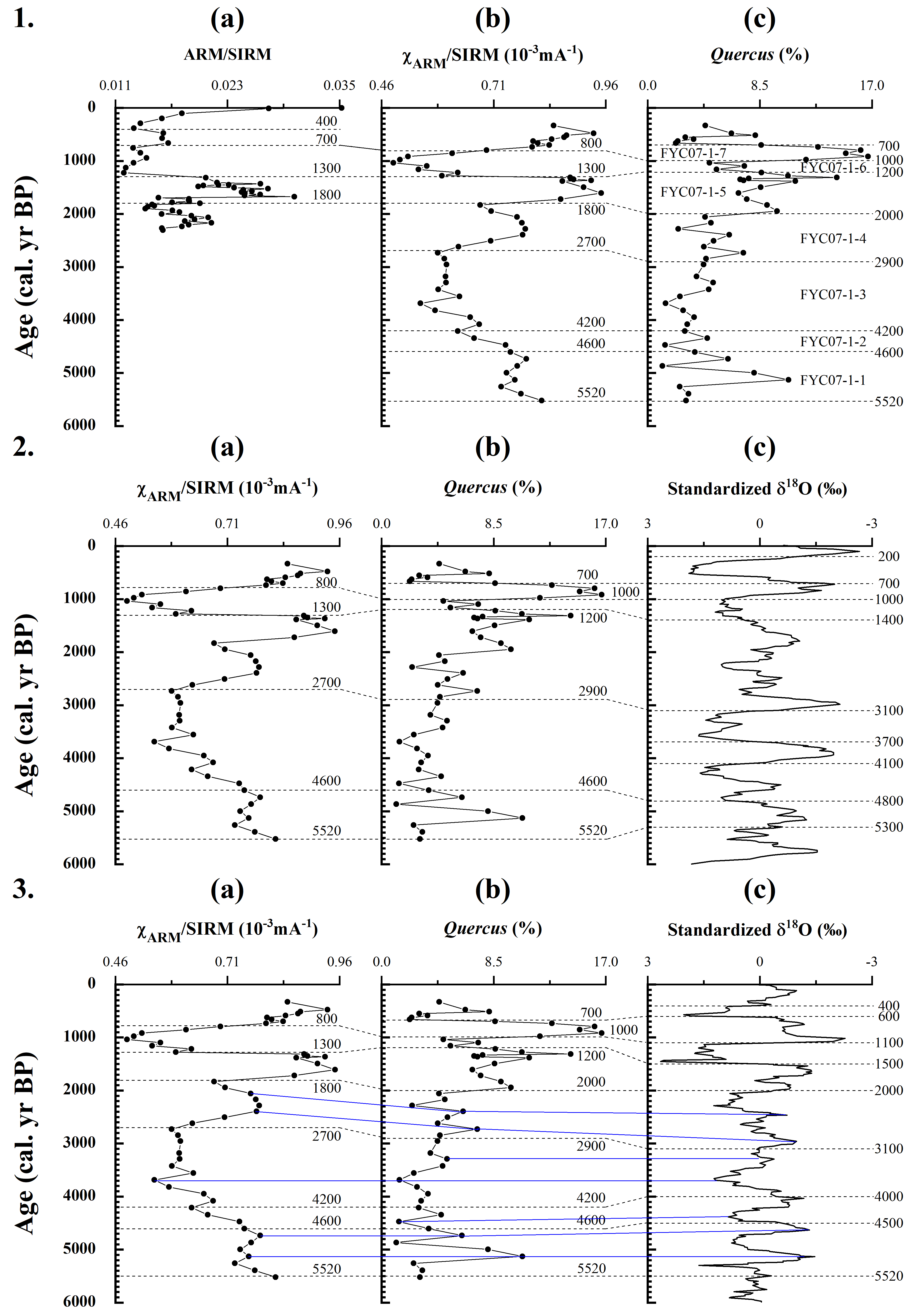
FYC07-1 in comparison with FY-C (another sediment sequence from Foye Chi) (1), a EASM record (2) and a EAWM record (3). 1(a): temporal variations in ARM/SIRM of FY-C (Wang et al., 2010); 1(b), 2(a) and 3(a): temporal variations in χARM/SIRM of FYC07-1 (this study); 1(c), 2(b) and 3(b): temporal variations in Quercus percentage of FYC07-1 (this study); 2(c): a record of EASM of δ18O of stalagmites from Heshang Cave (See Figure 1) (Hu et al., 2008); 3(c): a record of EAWM of δ18O of planktonic foraminiferal from SK-2 (see Figure 1) (Sagawa et al., 2014). In 3, the blue lines correlate the sub-ordinate fluctuations in χARM/SIRM and Quercus percentage of FYC07-1 to the corresponding ones in δ18O values of the EAWM record.
Comparing the FYC07-1 record with centennial-scale variability of EASM and EAWM
Environments have been strongly influenced by EASM and EAWM in east China where the Taibai Mountain is located (Figure 1). Thus, we have compared the FYC07-1 record with those of both EASM and EAWM to see if and how the environmental changes revealed by the sediments from the alpine lake coincide with variability of the two monsoons (Figure 13-2 and 3).
Hu et al. (2008) displayed a record of centennial-scale variability of Asian monsoon rainfall or EASM based upon δ18O of stalagmites (Figure 13-2c) from Heshang Cave (30°27’N, 110°25’E; 294 m a.s.l.), a dolomite cave in south China (Figure 1). As indicated by this record, there are four notable dry (weak EASM) periods during the last 6000 years (4800–4100, 3700–3100, 1400–1000 and 700–200 cal. yr BP), which are intervened by four humid (strong EASM) periods (5300–4800, 4100–3700, 3100–1400 and 1000–700 cal. yr BP). The relatively wet conditions around Foye Chi during 5520–4600 cal. yr BP may be related to the strong EASM period of 5300–4800 cal. yr BP indicated by the δ18O record (Figure 13-2a, b and c). As suggested by the δ18O record, EASM weakened and rainfall decreased during 4800–4100 cal. yr BP. However, the weakening of EASM was interrupted by a brief intensification of it occurring in 4100–3700 cal. yr BP. EASM weakened again and arid conditions recurred over 3700–3100 cal. yr BP. We related the generally dry conditions occurring during 4600–2900 or 2700 cal. yr BP around Foye Chi to the variability of EASM during 4800–3100 cal. yr BP though an amelioration corresponding to the intensification of EASM in 4100–3700 cal. yr BP has not been indicated by FYC07-1. The generally wet conditions during 2700–1300 or 2900–1200 cal. yr BP around Foye Chi can be ascribed to the strong EASM during 3100–1400 cal. yr BP. Furthermore, the very dry conditions in 1300–800 or 1200–1000 cal. yr BP and very wet conditions after 800 or during 1000–700 cal. yr BP around Foye Chi can be attributed to weak EASM during 1400–1000 cal. yr BP and strong EASM during 1000–700 cal. yr BP, respectively. Therefore, in spite of absence of a wet event corresponding to the intensification of EASM during 4100–3700 cal. yr BP, the environmental changes around Foye Chi have generally coincided with fluctuations of EASM during the past ~6000 years.
Sagawa et al. (2014) presented a record of centennial-scale variability of EAWM variability based on δ18O of planktonic foraminiferal (Figure 13-3c) from a sediment core (SK-2) retrieved in a site (41°11.09’N, 142°11.98’E; 1176 m water depth) off Shimokita Peninsula, northwest Pacific (Figure 1). This record indicates eight colder periods and seven warmer periods over the past 6000 years (Figure 13-3c) (Sagawa et al., 2014).
The relatively warm conditions persisting around Foye Chi during 5520–4600 cal. yr BP (Figure 13-3a and b) can be related to fluctuations of EAWM intensity during 5520–4500 cal. yr BP though there is a strong EAWM (cold) period (5000–4700 cal. yr BP) (Figure 13-3c). In particular, the sub-ordinary changes in environmental conditions around the alpine lake within 5520–4600 cal. yr BP coincided fairly well with the two weak EAWM periods (5300–5000 and 4700–4500 cal. yr BP) intervened by the strong EAWM one (5000–4700 cal. yr BP). Environments began to deteriorate around Foye Chi at 4600 cal. yr BP and were cooler during 4600–4200 cal. yr BP. We linked the deterioration around the alpine lake to changes in intensity of EAWM during 4500–4000 cal. yr BP within which the winter monsoon was particularly strong in 4500–4200 cal. yr BP. From 4200 cal. yr BP onwards, the climate has deteriorated dramatically in the monsoon influenced east China, which might be corresponding to ‘Holocene Event 3’. Correspondingly, environments were very cold around Foye Chi during 4200–2900 or 2700 cal. yr BP. The further deteriorated conditions can be somehow related to the fluctuations in the intensity of EAWM during 4000–3100 cal. yr BP. Within this time span, EAWM was very strong in 3800–3500 cal. yr BP, to which the coldest and driest conditions centred at ~3700 around Foye Chi were probably corresponding. Environments became relatively warm during 2700–1800 or 2900–2000 cal. yr BP around Foye Chi. This amelioration can be linked to variations in EAWM intensity happening in 3100–2000 cal. yr BP. EAWM was weak during 700 years (3100–2400 cal. yr BP) of the 1100 years. Once again, the sub-ordinary fluctuations in environmental conditions around Foye Chi within 2700–1800 or 2900–2000 cal. yr BP were also rather similar to the intra-span variations in EAWM intensity over 3100–2000 cal. yr BP. Since 2000 cal. yr BP, the changes in environmental conditions around Foye Chi have been more coincident with those in EAWM intensity. The very warm conditions of 1800–1300 or 2000–1200 cal. yr BP, very cold conditions of 1300–800 or 1200–1000 cal. yr BP and very warm conditions of <800 or 1000–700 cal. yr BP around Foye Chi (Figure 13-3a and b) can be linked to the weakened EAWM of 2000–1500 cal. yr BP, intensified EAWM of 1500–1100 cal. yr BP and weakened EAWM of 1100–600 cal. yr BP (Figure 13-3c), respectively.
So, in general, the environmental changes around Foye Chi are also attributable to the variations in EAWM intensity.
Conclusions
Variations in mineral magnetism of FYC07-1 from Foye Chi may have mainly reflected changes in erosion intensity and soil maturity in the catchment of this alpine lake and, with the aid of other data, have revealed environmental changes over the last ~5520 years. Environments were still relatively warm and wet during 5520–4600 cal. yr BP. Conditions deteriorated in 4600–4200 cal. yr BP and were very cold and dry in 4200–2700 cal. yr BP. Environments ameliorated in 2700–1800 cal. yr BP and were warm and humid in 1800–1300 cal. yr BP. Conditions became cold and precipitation declined again during 1300–800 cal. yr BP when effective humidity was probably still high due to low evaporation. Environments ameliorated again since 1000 or 800 cal. yr BP and were thus very warm and wet in a following period. With the weighted χARM/SIRM of FYC07-1 and χARM/SIRM of the surface soils distributed at different elevations, the altitudes at which the present climates are similar to the past ones were estimated for each of the above periods. At the altitude range where the main sediments were derived in the catchment, the climatic conditions prevailing during 5520–4600 cal. yr BP were probably similar to those occurring at 3410–3460 m a.s.l. at the present-time. When it was the coldest and driest during 1300–1000 or −800 cal. yr BP, the climate at the belt was similar to the one at 3480–3600 m a.s.l. nowadays. In contrast, the climatic conditions were similar to those at 3340–3420 m a.s.l. nowadays in the period of 1000–700 or starting from 800 cal. yr BP when it was the warmest and wettest.
The reconstructions have extended a 2300 years’ record of environmental changes based on mineral magnetism of another sediment sequence from the same lake. The environmental changes inferred with the sediments from the alpine lake in central east China are generally in agreement with centennial-scale variability of EASM based upon δ18O of stalagmites, a dolomite cave in south China, and of EAWM based on δ18O of planktonic foraminiferal of marine sediments from north Pacific.
Footnotes
Acknowledgements
We are very grateful to Mr. Hongtao Cheng for his help in doing fieldwork on Taibai Mountain and to Professor Yiying Li for her help in doing pollen analysis. We are also indebted to Professor Xiaohong Wu and Professor Yan Pan who have conducted the AMS 14C dating, to Professor Liping Zhou for his help in doing particle-size analysis, to Dr. Linjing Liu for his help in doing isotopic nitrogen analysis and to Professor Zhixian Wang for her help with doing TOC and TN analysis. Finally, we would like to extend our gratitude to the anonymous reviewer who helped to improve this manuscript.
Funding
The author(s) disclosed receipt of the following financial support for the research, authorship, and/or publication of this article: This research is supported by a grant from NSF of China (41171160).
