
Abstract
Climate warming in Svalbard since the end of the ‘Little Ice Age’ early in the 20th century has reduced glacier extent in the archipelago. Previous attempts to reconstruct ‘Little Ice Age’ glacier limits have encountered problems in specifying the area of tidewater glacier advances because it is difficult to estimate the past positions of their marine termini. Multibeam echo-sounding data are needed to map past glacier extent offshore, especially in open-marine settings where subaerial lateral moraines cannot be used due to the absence of fjord walls. We use the submarine glacial landform record to measure the recent limits of advance of over 30 marine-terminating northeastern Svalbard glaciers and ice caps. Our results demonstrate that previous work has underestimated the ice-covered area relative to today by about 40% for northeastern Svalbard (excluding southeast Austfonna) because marine-geophysical evidence in the form of submarine terminal moraines was not included. We show that the recent ice extent was 1753 km2 larger than today over our full area of multibeam data coverage; about 5% of the total modern ice cover of Svalbard. It has often been assumed that moraine ridges located within a few kilometres of modern ice fronts in Svalbard represent either a ‘Little Ice Age’ maximum or relate to surge activity over the past century or so. In the marine environment of northeastern Svalbard, this timing can often be confirmed by reference to early historical maps and aerial photographs. Assemblages of submarine glacial landforms inshore of recently deposited terminal moraines suggest whether a recent advance may be a result of surging or ‘Little Ice Age’ climatic cooling relative to today. However, older terminal moraines do exist in the archipelago, as shown by radiocarbon and 10Be dating of Holocene moraine ridges.
Keywords
Introduction
The climate of the 62,000 km2 Arctic archipelago of Svalbard has changed markedly over the past few centuries. After a cool period of several hundred years, known as the ‘Little Ice Age’ (Grove, 1988), from about the 14th to the end of the 19th century, Svalbard has warmed considerably over the past century or so. After a notable rise of 5°C in the second decade of the 20th century, the climate first stabilised and then cooled again during the 1960s, before renewed warming since that time (Humlum et al., 2005; Nordli et al., 2014). Svalbard has experienced the largest temperature rise in Europe over the past 30 years (Nordli et al., 2014), a manifestation of the particular sensitivity of the Arctic to environmental change (IPCC, 2013). These recent changes in climate have resulted in the retreat and thinning of many individual glaciers and ice-cap outlets on Svalbard, especially over the past few decades (e.g. Blaszczyk et al., 2009; Malecki, 2016; Nuth et al., 2010, 2013).
Geological evidence from terrestrial moraines and lake sediments suggests that glaciers on Svalbard reached their ‘Little Ice Age’ maximum between about 1890 and 1920 (e.g. Glasser and Hambrey, 2006; Humlum et al., 2005; Snyder et al., 2000; Svendsen and Mangerud, 1997). Since that time, many glaciers have retreated systematically, whereas some others have also undergone one or more subsequent readvance. Readvances of some glaciers have taken place because superimposed on climate-driven changes in glacier mass balance in Svalbard (e.g. Hagen et al., 2003) is the internal glacier instability known as surging (Meier and Post, 1969; Murray et al., 2003; Sevestre and Benn, 2015). Surges are rapid glacier advances of a few years in duration followed by slow retreat over decades in response to changing basal hydrology, driven largely by glacier geometric and thermal change (e.g. Benn et al., 2019; Murray et al., 2003). Many Svalbard glaciers, including a large number of tidewater-terminating ice masses, are of surge-type (e.g. Dowdeswell et al., 1991, 1995; Farnsworth et al., 2016; Hagen et al., 1993; Hamilton and Dowdeswell, 1996; Jiskoot et al., 1998; Liestøl, 1969; Schytt, 1969; Sund et al., 2014). Thus, changes in the extent of Svalbard glaciers over the past few hundred years, and perhaps also during the Holocene (Farnsworth et al., 2018; Flink and Noormets, 2018), are likely to be linked to a combination of both external climatic and internal glaciological factors.
The ‘Little Ice Age’ extent of Svalbard glaciers has been estimated recently using aerial photographic interpretation and geographic information system (GIS) methods (Martin-Moreno et al., 2017). In particular, the present and past positions of glacier fronts and terrestrial moraine systems were mapped. The investigation quite properly acknowledged several difficulties in the work. One problem related to a lack of information on the past positions of tidewater glacier margins for defining recent ice extent across the archipelago, although historic descriptions, aerial photographs dating back to 1936 and satellite images provided much useful evidence (e.g. Lefauconnier and Hagen, 1991; Liestøl, 1969; Schytt, 1969). A second problem was linked to distinguishing between recent glacier maxima associated with surging as opposed to climate cooling. Martin-Moreno et al. (2017) used lateral moraines on valley sides to reconstruct the likely recent maximum positions of tidewater glaciers in many fjords, but where glaciers reach the sea in more open-marine settings or where fjords are particularly wide, seafloor morphological data are important in providing key information for the reconstruction of past ice extent. An open-marine setting is particularly common in the heavily glaciated northeastern part of Svalbard, where glaciation is dominated by ice caps and large outlet glaciers reaching to the coast (Bamber and Dowdeswell, 1990; Dowdeswell, 1986a; Dowdeswell and Bamber, 1995; Dowdeswell et al., 2008; Hagen et al., 1993; Lefauconnier and Hagen, 1991).
In this paper, we use high-resolution marine-geophysical data on the morphology of the seafloor offshore of tidewater-terminating glaciers in northeastern Svalbard to provide new evidence on glacier area and fluctuations which may be linked mainly to either recent climate change or to surging. Using these submarine morphological data, including terminal and retreat moraines and associated landform-assemblages (e.g. Dowdeswell et al., 2016a, 2016b; Flink et al., 2017; Forwick et al., 2016; Ottesen and Dowdeswell, 2006; Ottesen et al., 2008, 2017; Solheim, 1985, 1991; Solheim and Pfirman, 1985; Streuff et al., 2017), we provide a new estimate of recent tidewater glacier maximum positions and subsequent retreat in the part of Svalbard that includes much of northeastern Spitsbergen, Nordaustlandet and Barentsøya (Figure 1).
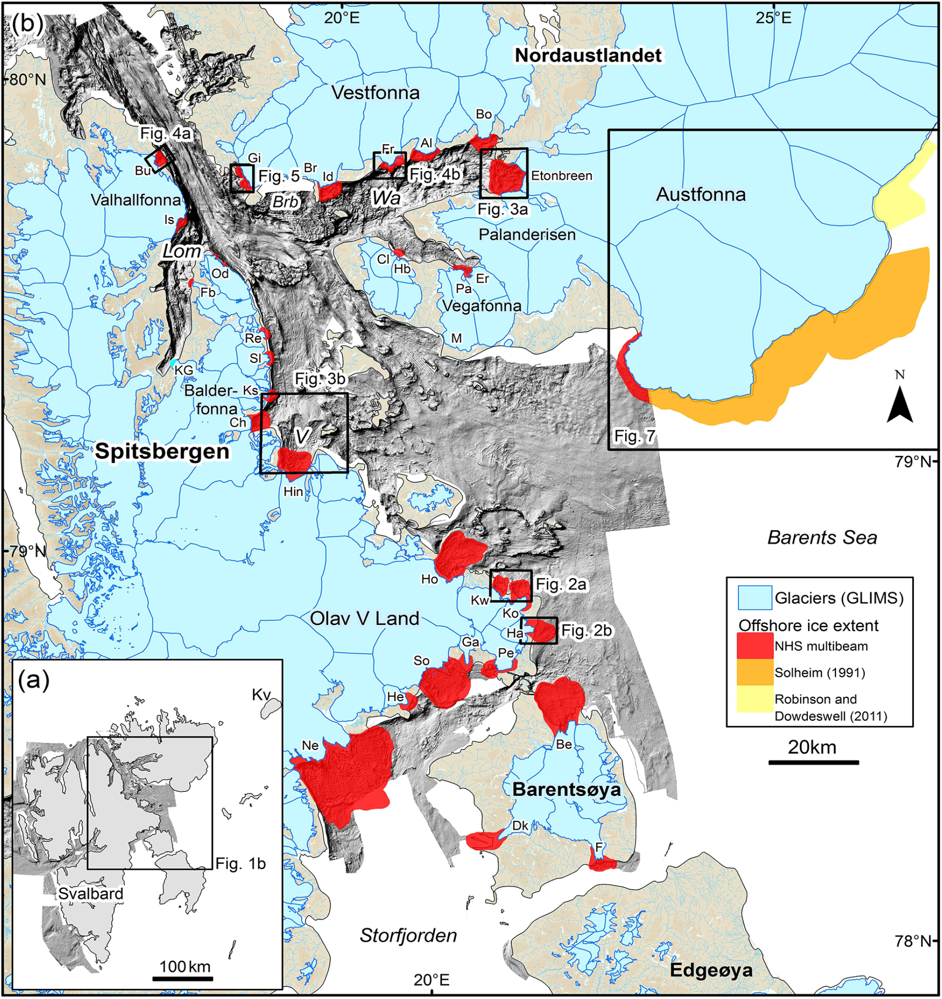
Location maps. (a) Study area in Svalbard and marine-geophysical data coverage (grey). (b) Recent advances of glaciers around northeastern Svalbard, inferred from terminal moraine ridges observed in multibeam bathymetry (shown in red). Glaciers are shaded blue and drainage basins are shown by thin blue lines.
Marine-geophysical data and methods
A large amount of high-resolution multibeam swath-bathymetric data has been collected by the Norwegian Hydrographic Service (NHS) around the northeast of Svalbard during 1993, 1994, 1995, 1996, 1997, 1998, 1999, 2007, 2008, 2009, 2011, 2013 and 2014. The NHS data coverage offshore of northeastern Spitsbergen, Nordaustlandet and Barentsøya is shown in Figure 1b. The data were acquired using Kongsberg EM100 and EM300 (from 1993 to 1998), and EM1002, EM2040, EM3000, EM3002 or EM710 multibeam echo-sounders thereafter. The data were initially processed by the NHS for tidal corrections and the removal of false data points and artefacts. These regional data were gridded with a cell size of 20 m (Figure 1), but we also have access to the raw data, which enabled us to reprocess and grid the data with 1 or 2 m cell size. Our mapping of seafloor glacial landforms uses a 2-m grid-cell size and has a vertical resolution of better than 1 m (Ottesen et al., 2017). We also use multibeam data from a 2006 cruise of the RRS James Clark Ross where multibeam bathymetric data were acquired using a Kongsberg EM120 system and gridded at 12-m resolution (Robinson and Dowdeswell, 2011). A detailed technical review of multibeam echo-sounding techniques and seafloor mapping is given in Jakobsson et al. (2016).
The multibeam bathymetric maps of the seafloor adjacent to northeastern Spitsbergen, Nordaustlandet and Barentsøya were examined for evidence of submarine glacial landforms indicative of recent ice extent beyond the present coastline and glacier margins. Former ice-front positions were mapped through the identification of terminal moraine ridges, often tens of metres high and hundreds of metres wide, which are commonly observed in many formerly ice-covered fjords and continental shelves (e.g. Burton et al., 2016; Graham and Hodgson, 2016; Lastras and Dowdeswell, 2016; Shaw, 2016). The crests of such ridges were used to define past ice limits. This approach is suitable because Svalbard, unlike the adjacent and colder Russian Arctic archipelagos of Franz Josef Land and Severnaya Zemlya (Dowdeswell, 2017; Dowdeswell et al., 1994; Williams and Dowdeswell, 2001), contains no floating ice shelves or glacier tongues beyond grounded tidewater glaciers either today or, probably, during the ‘Little Ice Age’ (Dowdeswell, 1989); the grounding line is therefore in the same location as the terminal ice cliffs. Exceptionally, short-lived floating tongues of ice may form as transient features at the outer edges of surge-type tidewater glaciers, especially when they are advancing or retreating into deepening water (Dowdeswell, 2017). The observation of tabular icebergs at the retreating margin of Besselsbreen, an outlet of Barentsjøkulen on Barentsøya, in 1936 aerial photography is an example of where such a transient floating ice margin may have existed (Ottesen et al., 2017). Such transient behaviour has little effect on our mapping of recent ice extent.
Marine-geophysical evidence of past ice-front positions was then combined in a GIS with the modern position of tidewater glacier termini in northeastern Svalbard to derive changes in ice extent. About 740 km of marine-terminating ice cliffs are present around Svalbard today, draining approximately 68% of the ice-covered area of the archipelago (Nuth et al., 2013). Following Martin-Moreno et al. (2017), we used shapefiles from the digital glacier database for Svalbard to obtain outlines of the modern margins of tidewater glaciers (Kӧnig et al., 2014; Nuth et al., 2013). The satellite-derived glacier margins in this database, produced as part of the Global Land Ice Measurements from Space (GLIMS) project, represent the time interval 2001–2010, with the precise year for any area depending on image availability; these data provide the only complete spatial coverage of ice extent on Svalbard (Kӧnig et al., 2014). The satellite data were derived from ortho-rectified images acquired from the SPOT-5 (horizontal resolution 20 m or better) and ASTER (horizontal resolution 30 m or better) satellite sensors.
Whether the mapped submarine terminal moraine ridges represented a past glacier surge or a simple response to the cooler climate of the ‘Little Ice Age’, or possibly even an earlier advance, was then inferred using two lines of evidence. Where available, direct observations of past glacier-front positions and ice-surface characteristics from early aerial photographs and explorers’ reports were used: rapid advance, heavy surface crevassing and looped medial moraines are each regarded as indications of past surges (e.g. Copland et al., 2003; Grant et al., 2009; Meier and Post, 1969). This information was supplemented by examination of the assemblage of submarine glacial landforms inshore of the terminal moraine ridges; tidewater glaciers that have surged and then retreated reveal a characteristic set of well-preserved subglacial and ice-marginal landforms that provide evidence of past surge activity (Dowdeswell and Ottesen, 2016; Flink et al., 2015, 2017; Ottesen and Dowdeswell, 2006; Ottesen et al., 2008, 2017; Solheim and Pfirman, 1985).
In addition, it is possible that some of the outermost submarine terminal moraine ridges observed in northeast Svalbard waters may belong to post-Weichselian ice readvances during the Holocene that pre-date the ‘Little Ice Age’. Where available, previously published absolute dates are used to provide absolute ages for glacimarine and associated submarine moraine ridges.
Results: Mapping the recent extent of tidewater glaciers from multibeam bathymetry
Overall changes
The large (8100 km2) NHS dataset of multibeam bathymetry from the waters of northeast Svalbard is used to map the maximum recent extent of tidewater glaciers and ice-cap margins (Figure 1b, Table 1). The multibeam data were examined systematically for submarine morphological evidence of recent ice advances – examples of well-defined terminal moraines and associated landform-assemblages inside these moraine systems are shown in Figures 2 and 3. In some cases, lobate submarine debris flows run out into deeper water distal to the ridges. Aside from these debris lobes, beyond the outermost moraine ridges, the seafloor is typically relatively smooth and occasionally ploughed by the grounding of drifting icebergs (Figure 2). The submarine terminal moraine ridges allowed the areas beyond modern ice margins where glaciers have recently advanced across the seafloor to be mapped and measured. In Wahlenbergfjorden, western Nordaustlandet (Figure 3a), and Lomfjorden, northeast Spitsbergen (Figure 1b), our interpretations of terminal moraine locations were compatible with earlier mapping of submarine glacial landforms by Flink et al. (2017) and Streuff et al. (2017), demonstrating the reproducibility of this approach.
LH: Lefauconnier and Hagen (1991); MBB: Multibeam echo-sounder bathymetry.
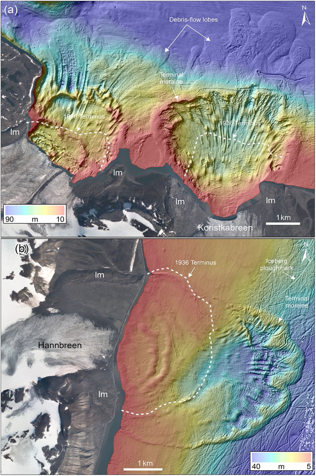
Multibeam bathymetric evidence of recent advances of Olav V Land glaciers into the open-marine setting of the Barents Sea (© Kartverket). (a) Koristkabreen (Ko in Figure 1b) and an adjacent unnamed glacier. (b) Hannbreen (Ha in Figure 1b). Landforms labelled lm are lateral moraines on land. Aerial photographs from 1936 show each of these glaciers to be at or close to the lateral moraines (lm) shown in this figure and to cover the inner sets of transverse moraines visible in the multibeam data (Ottesen et al., 2017).
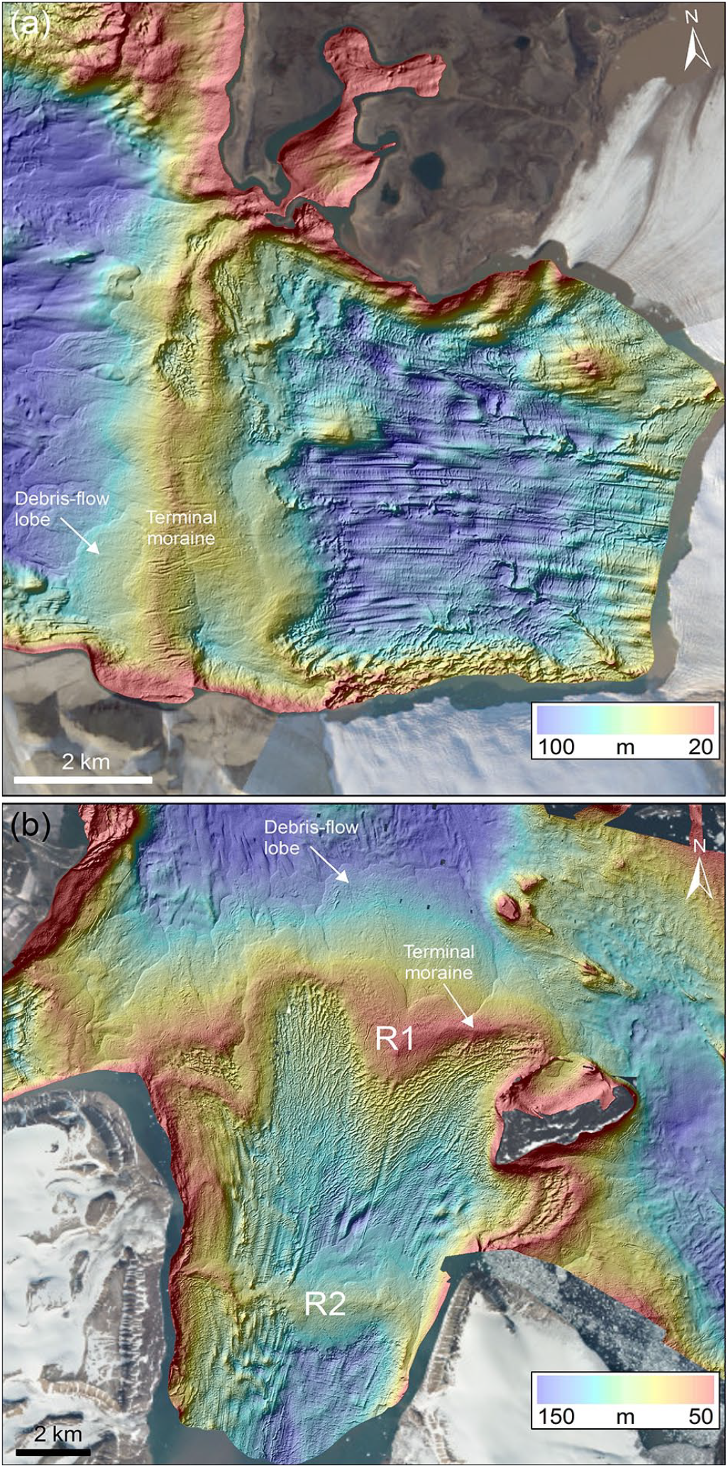
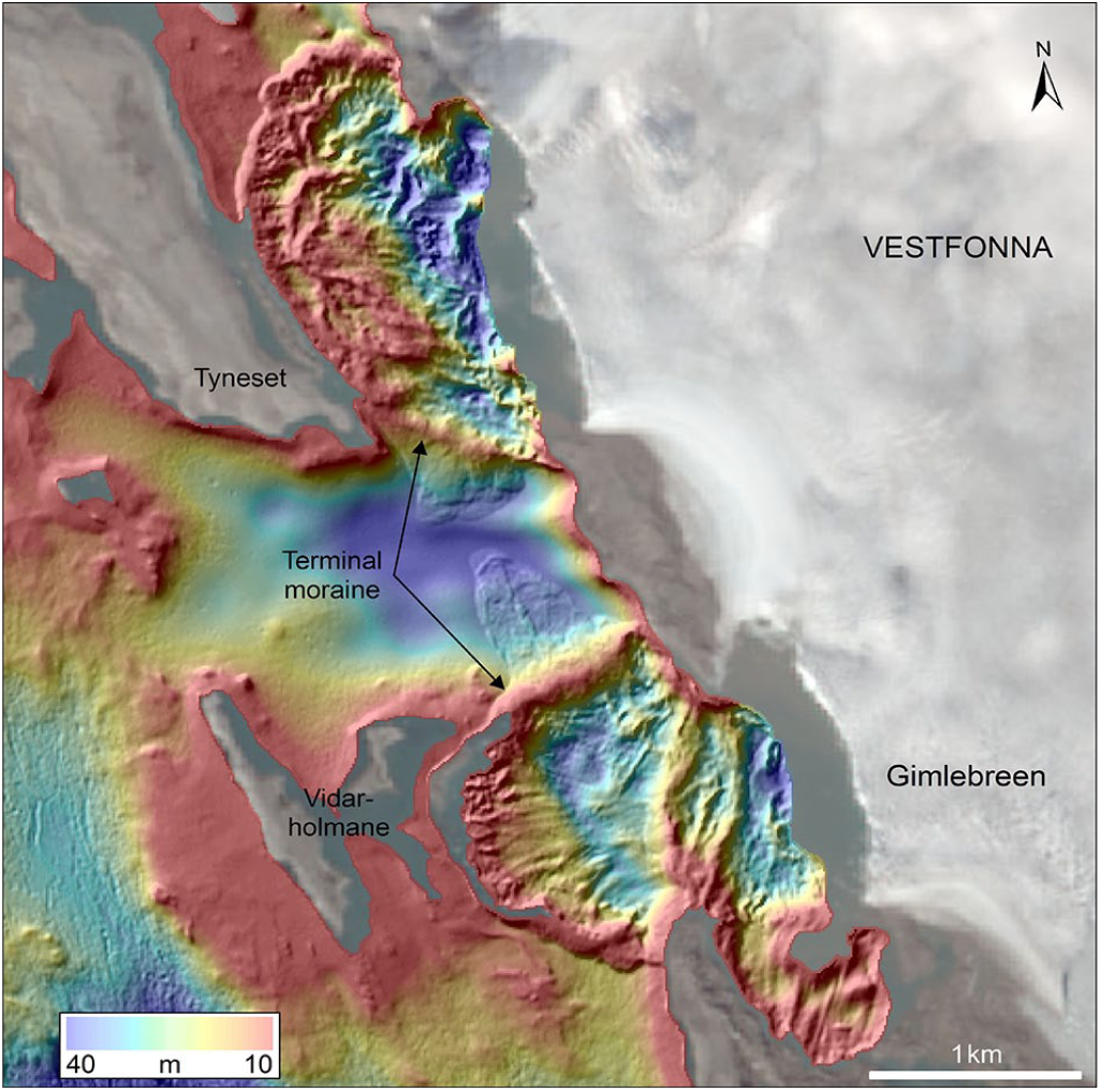
Multibeam bathymetric evidence of recent ice advance from fjords (© Kartverket). (a) Etonbreen, an outlet glacier of western Austfonna, Nordaustlandet (located in Figure 1b). (b) Hinlopenbreen, a large outlet glacier in Olav V Land, northeastern Spitsbergen (located in Figure 1b). R1 is the older ridge (with a minimum radiocarbon age of 2.6 kyr) and R2 is the younger ridge, probably from the ‘Little Ice Age’ (Flink and Noormets, 2018).
There are more than 30 glaciers in northeast Svalbard for which there is marine-geological evidence of recent ice advance, in the form of terminal moraine ridges and associated glacial landforms; 17 in northeastern Spitsbergen, 3 on Barentsøya and 12 on Nordaustlandet, plus the ice cliffs of southeastern Austfonna (Figure 1, Table 1). These glaciers represent almost all of the larger drainage basins in the study area, implying that the vast bulk of tidewater glaciers have advanced since late Weichselian regional deglaciation before retreating subsequently to their modern positions. Climatic evidence of a substantial temperature rise on Svalbard at the end of the cool ‘Little Ice Age’ at the beginning of the 20th century (Nordli et al., 2014), combined with direct observations (from historical sources and early aerial photographs) and lichenometric dating on some land-based moraine systems (e.g. Werner, 1993), implies that many prominent submarine and terrestrial moraine systems were formed at this time.
The total area of our measured recent glacier expansion, relative to the GLIMS database of modern (2001–2010) ice-front positions, is 1753 km2. These changes in marine-terminating ice extent are considerable and represent the loss of about 5% of the ice-covered area of the whole Svalbard archipelago (modern glacierized area 33,200 km2; Kӧnig et al., 2014) over the past century or so. The previous work by Martin-Moreno et al. (2017) suggested that ice covered an additional 544 km2 compared with today (excluding southeastern Austfonna where they considerably overestimate the extent of recent ice cover – Figure 7). By contrast, using marine-geophysical data, we map an area of 842 km2 for recent-past ice extent (Figure 6, Table 1), representing an increase of about 40% relative to the measurements of Martin-Moreno et al. (2017) (excluding Bragebukta glaciers and Holtenbreen where there are no marine-geophysical observations).
Along most of the remaining coastline adjacent to the NHS bathymetric data, the situation is either that the bathymetric data coverage begins a number of kilometres offshore of the present ice margin or that ice does not reach down to sea level. A clear example of the former situation is adjacent to southwestern Vestfonna on Nordaustlandet, where the edge of the bathymetric data in Bragebukta is about 4 km from the adjacent tidewater glacier margin (Figure 1b). There is, therefore, no opportunity to map any past ice advance of less than this distance, although the seafloor-bathymetric data further offshore show no evidence of recent ice advance into Bragebukta (Figure 1).
The influence of topographic setting: Open-marine coastlines compared with fjords
There are two general regional-topographic settings in which recent ice advances into marine waters have been identified in northeast Svalbard: open-marine coastlines and fjords. Examples of terminal moraines and associated submarine landforms extending into open-marine settings are illustrated by Koristkabreen and an adjacent unnamed glacier (Figure 2a) and the nearby Hannbreen (Figure 2b). In each case, very well-preserved terminal moraine ridges are clearly identifiable, forming an arcuate pattern beyond the coastline. Inside the terminal ridges are shallow basins that contain assemblages of subglacial and ice-marginal sedimentary landforms that include streamlined and often radial lineations, indicating the direction of past ice flow, and sets of transverse-to-flow recessional ridges of varying dimensions, first mapped by Ottesen et al. (2017). Lateral moraines are also seen on the adjacent land surfaces, and the submarine terminal moraines can often be traced seaward from the ends of the lateral moraines (Figure 2). The magnitude of tidewater-glacier retreat from the terminal moraines marking maximum recent advance to the modern glacier termini has been 3.5 km (17 km2), 2 km (9 km2) and 4 km (20 km2) for Koristkabreen (Koristkabreen East in Table 1), the unnamed glacier (Koristkabreen West in Table 1) and Hannbreen, respectively (Figures 1b and 2).
The second regional-topographic setting for recent ice advance is in more laterally constrained fjords, as exemplified by Etonbreen, an outlet glacier of Austfonna on Nordaustlandet (Figures 1b and 3a). This area, first mapped by Flink et al. (2017), shows that the arcuate terminal ridges and radial streamlined landforms of open-marine settings are replaced by terminal moraines that extend more linearly across the fjord and streamlined, subglacially produced sedimentary landforms that are orientated sub-parallel to constraining fjord sides (Figure 3a). Etonbreen is interpreted to have undergone about 5 km of recent advance relative to its modern margin (Figures 1b and 3a).
Confining fjord walls have also influenced the pattern of submarine glacial landforms associated with recent advances of Hinlopenbreen (Figures 1b and 3b), the largest outlet glacier draining Olav V Land (Figure 1b). In the fjord itself, the submarine landforms are orientated nearly parallel to the fjord walls and there is a transverse-to-flow ridge across the fjord about 8 km from the present glacier terminus (labelled R2 in Figure 3b). There is, however, evidence that the glacier has extended further, beyond the constraining fjord walls, and spread out radially into a more open-marine setting. The form of the most distal terminal moraine ridge about 16 km from the modern ice front is arcuate (labelled R1 in Figure 3b). This ridge also exhibits a finger-like morphology that probably reflects the break-up of the advancing margin into several filaments (Figure 3b). This is a pattern of ice advance observed on several tidewater glaciers that are currently surging into open-marine waters in northeast Svalbard (e.g. Ottesen et al., 2017).
It is likely, in addition, that offshore water depth also provides a topographic constraint on the distance of recent ice advance. This is because of the positive relationship between iceberg calving rate and water depth, which has been investigated both empirically (Brown et al., 1982; Pelto and Warren, 1991) and through numerical modelling (e.g. Benn et al., 2007; Vieli et al., 2001, 2002). Grounded ice becomes progressively more buoyant as water depth increases, allowing greater calving of icebergs, with the effect that ice flux from the interior drainage basin becomes insufficient to allow further advance of the glacier terminus. Examples are shown in Figure 4 where enhanced calving into rapidly deepening offshore water has restricted ice advance from two northeast Svalbard tidewater glaciers. In these cases, submarine glacial landforms demonstrate recent sedimentary deposition, but well-defined terminal moraines have failed to form because the location of the grounding zone during advance was probably at the marked break in slope into deeper water, preventing further ice advance and restricting the buildup of sediments necessary for terminal ridge formation (Figure 4). In fact, debris-flow lobes beyond the break in slope show that glacial sediment delivered to the grounding zone was transported downslope into deeper fjord water (Figure 4).

Whereas the terminal moraines seaward of many tidewater glacier termini in northeast Svalbard show that advances of a number of kilometres have taken place, there are some modern ice margins where advances have been limited to less than a kilometre (Figure 1b, Table 1). Such areas, nonetheless, contain distinctive submarine landform-assemblages, in some cases terminating on adjacent islands. Two examples from the west side of the 2500 km2 Vestfonna ice cap on Nordaustlandet are shown in Figure 5. Here, the advancing ice fronts drain small sectors of the ice-cap margin that do not have well-defined outlet glaciers. The lack of ice flux from these limited interior basins may explain, together with the constraining offshore-island topography, the lack of more major recent advances.
Multibeam bathymetric evidence of minor recent ice advance of ice-cap margins: an example from the southwestern side of Vestfonna on Nordaustlandet (© Kartverket).
Comparing recent and modern ice extent in northeastern Svalbard
Northeastern Spitsbergen and Barentsøya
Along most of the coast of northeastern Spitsbergen, the use of marine-geophysical data allows the identification of submarine terminal moraines (Figures 2, 3 and 5) and the mapping of recent advances of marine-terminating glaciers and ice caps (Figure 6, Table 1). The largest recent ice advance in eastern Spitsbergen, that of the known surge-type glacier Negribreen, covered an area of about 310 km2 (Figure 6). Sonklarbreen underwent the next largest recent advance of 85 km2 (Figure 6). The areas of recent advance derived from the analysis of multibeam echo-sounder data and from the work of Martin-Moreno et al. (2017) are compared in Figure 6 and Table 1. Along much of the coast of Olav V Land, which is mainly an open-marine environmental setting, the marine-geophysical data usually record a greater recent ice extent than does the earlier work (Figures 2 and 6). This is probably because the lack of multibeam bathymetric data available to Martin-Moreno et al. (2017) enabled them to provide only a minimum estimate of recent ice extent based on aerial photographic evidence from 1936 and the mapping of lateral moraines on land (Lefauconnier and Hagen, 1991).
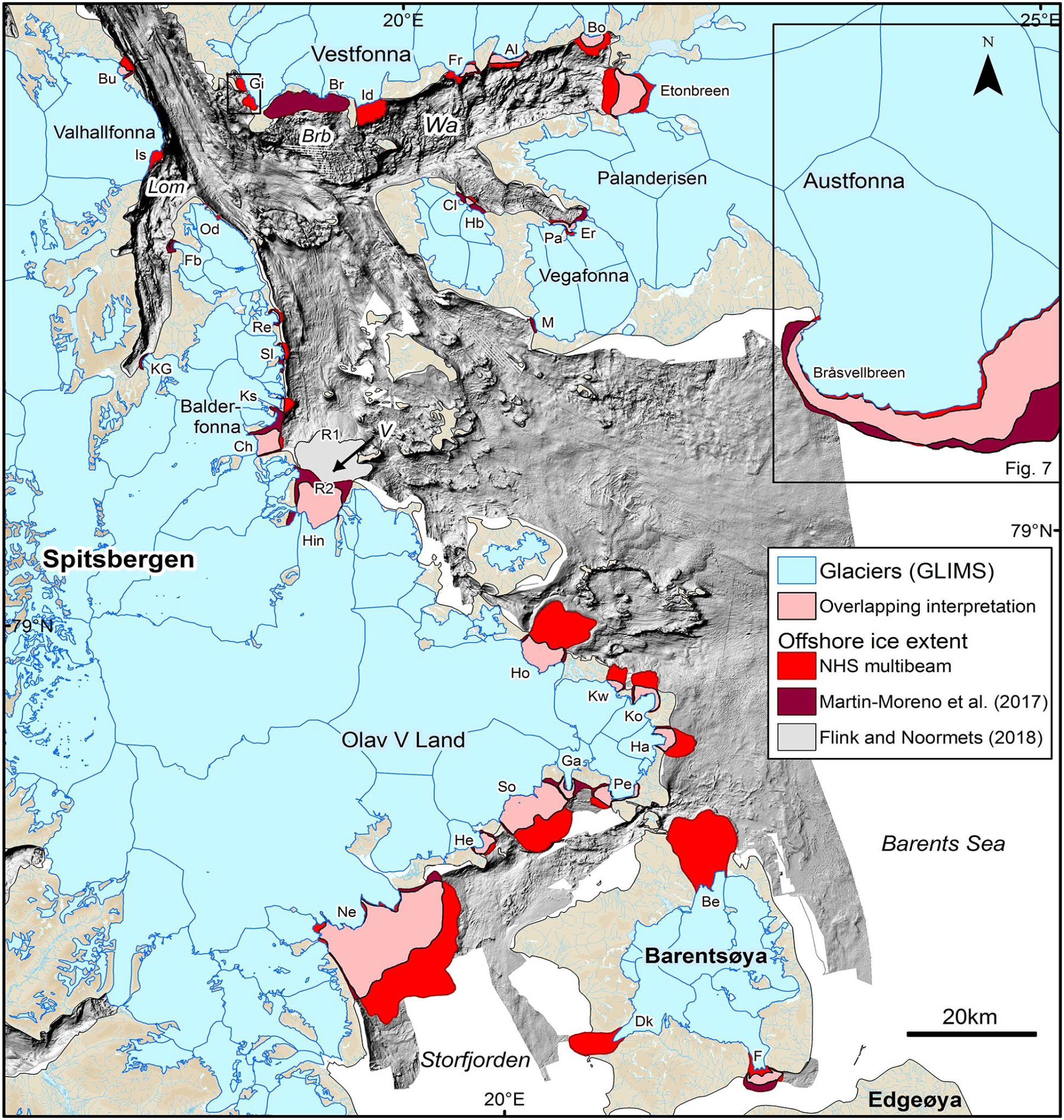
Comparison of recent maximum ice extent in northeastern Svalbard from NHS multibeam evidence (mid red) with earlier mapping by Martin-Moreno et al. (2017) (dark red). Light red areas represent overlap of the two interpretations. Note the greater extent of Hinlopenbreen (Hin) marked by an earlier Holocene ridge (R1 – minimum radiocarbon age of 2.6 kyr; Flink and Noormets, 2018) located beyond a likely ‘Little Ice Age’ terminal ridge (R2).
On Barentsøya, the recent advances of Besselsbreen and Duckwitzbreen are unmapped by Martin-Moreno et al. (2017), although retreats of 6 and 3 km, respectively, are reported in their text, based on the interpretation of 1936 aerial photography by Lefauconnier and Hagen (1991). Marine-geophysical data show clearly the position of recent submarine terminal moraines, which are about 11 km from the present ice front in the case of Besselsbreen (Ottesen et al., 2017). The tidewater glacier at that time covered an increased area of 93 km2 relative to the modern ice margin (Figure 6, Table 1). Combining this with our marine-geophysical measurements of ice advance for the tidewater glaciers Freemanbreen and Duckwitzbreen, this gives a recent ice extent of about 130 km2 greater than today. This is larger by about 20% than the 107 km2 of ice retreat estimated for the whole ice cap on Barentsøya (presumably from tidewater glaciers Besselsbreen, Duckwitzbreen and Freemanbreen, together with several small advances by terrestrial glaciers) since the ‘Little Ice Age’ by Martin-Moreno et al. (2017), again demonstrating that the latter are often providing only a minimum estimate of recent ice advance when tidewater glaciers are considered.
The offshore record of submarine moraine ridges may occasionally reflect earlier ice advances. Flink and Noormets (2018) have shown that the outermost set of prominent moraine ridges about 16 km north of the modern terminus of Hinlopenbreen (R1 in Figures 3b and 6) is likely to be significantly older than the ‘Little Ice Age’, with a minimum radiocarbon age of 2.6 kyr. By contrast, an inner submarine ridge, no more than about 8 km from the contemporary ice front of Hinlopenbreen (R2 in Figures 3b and 6), matches well with 1901 observations of the position of the ice front (De Geer, 1923; Vassiliev, 1907). Without detailed marine-geophysical evidence at their disposal, Martin-Moreno et al. (2017) appeared to locate the ‘Little Ice Age’ maximum of Hinlopenbreen at the mouth of the fjord in which the glacier now sits, a little beyond the R2 ridge mapped in Figure 3b, covering an area of about 52 km2 (Figure 3b). This represents a small overestimate of the likely ‘Little Ice Age’ ice extent of about 38 km2 relative to our marine-geophysical data (Figure 6). The maximum Holocene advance of Hinlopenbreen, reported by Flink and Noormets (2018), gives an increased ice extent of 121 km2 relative to today.
Nordaustlandet and Kvitøya
Where multibeam echo-sounding data are available in the fjords of Nordaustlandet, as in Wahlenbergfjorden (Figure 1b) (Flink et al., 2017), the marine-geophysical data again suggest a larger extent of recent advances than does the analysis of Martin-Moreno et al. (2017) (Figure 5); Etonbreen provides a clear example, where our estimate is 21 km2 larger (Figures 3a and 6). However, the difference in recent extent is often not more than a kilometre or two, probably because in fjords, rather than open-marine topographic settings, lateral moraines on adjacent land can be used to infer the limits of past ice extent relatively effectively.
The ice-cap margin of southeastern Austfonna, the longest continuous stretch of marine ice cliffs in the Northern Hemisphere (Dowdeswell et al., 2008, 2015), represents the most significant part of northeast Svalbard where the mapped recent extent of ice by Martin-Moreno et al. (2017) is greater than our estimate (Figure 7). Our mapping was based on a combination of multibeam echo-sounder surveys and other marine-geological data (Robinson and Dowdeswell, 2011; Solheim, 1985, 1991) (Figure 1b). For the 125-km length of Austfonna’s marine ice cliffs for which we have evidence, ice advanced to cover an additional 990 km2 relative to today, much of this related to a major surge of Bråsvellbreen in the 1930s (Schytt, 1969). The discrepancy with the earlier estimate by Martin-Moreno et al. (2017), an area of about 220 km2 (Figure 7a), demonstrates the importance of being able to use high-quality marine evidence relating to seafloor landforms, and especially submarine terminal moraine ridges, to enable accurate mapping of past ice extent in open-marine settings. Quite rightly, Martin-Moreno et al. (2017) acknowledged the almost complete lack of data north of about 79°40′N offshore of northeastern Austfonna with a series of question marks, but they nonetheless include a speculative area of about 470 km2 in their estimate of ‘Little Ice Age’ ice extent. In this area, multibeam echo-sounder data are only available from much further offshore in the relatively deep water of Erik Eriksenstret and Kvitøya Trough, where no submarine terminal moraines are present (Hogan et al., 2010a, 2010b). We do not provide an estimate of the extent of recent ice advance due to the lack of marine-geophysical evidence.
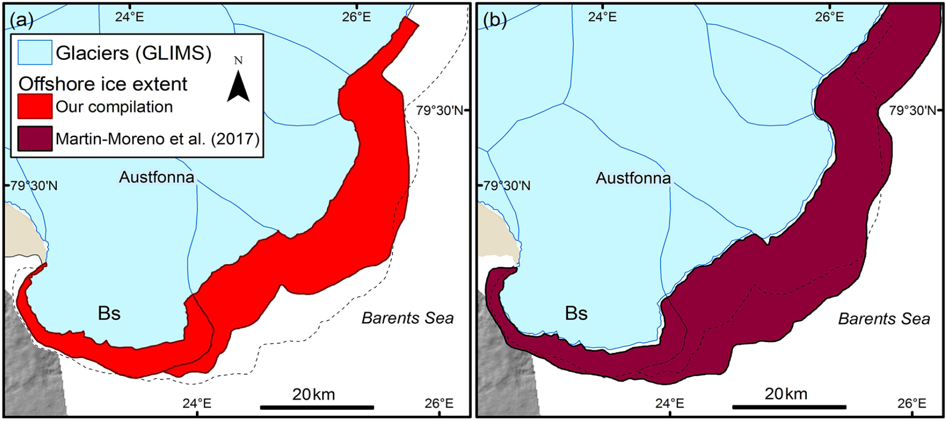
Comparison of the recent maximum ice extent for the ice cliffs of southeastern Austfonna derived from several sources. (a) Our compilation of NHS multibeam data, multibeam imagery from a cruise of the RRS James Clark Ross (Robinson and Dowdeswell, 2011) and the seafloor mapping of Solheim (1991) from earlier marine-geophysical and geological work. Note the dashed line that indicates the maximum recent ice limit from Martin-Moreno et al. (2017). (b) The mapping of Martin-Moreno et al. (2017), which appears to use 1936 oblique aerial photographs (Lefauconnier and Hagen, 1991) and elements of the seafloor mapping of Solheim (1991). Note the dashed line that indicates the maximum recent ice limit from our compilation.
Finally, the northeasternmost island in the Svalbard archipelago, Kvitøya, is discussed briefly. This island, about 70 km to the east of Nordaustlandet (Figure 1a), is almost completely ice covered. The ice cap of Kvitøyjӧkulen, which has a simple form of two main domes and is a maximum of 300 m thick (Bamber and Dowdeswell, 1990), has a modern area of 647 km2 (Martin-Moreno et al., 2017). Little change in ice extent has taken place between aerial photographs, acquired in 1956 and 1977, and modern satellite imagery (Lefauconnier and Hagen, 1991; Martin-Moreno et al., 2017). Given that the ice cap terminates almost completely in the sea, Kvitøya provides a clear example of the need for marine-geophysical mapping to establish whether or not any submarine moraines are present offshore to indicate if Kvitøyjӧkulen may have been larger during the cool ‘Little Ice Age’. To date, no such data are available and so little can be said about Kvitøyjӧkulen’s pre-1956 dimensions.
Timing and causes of observed ice advances
‘Little Ice Age’ cooling
The ‘Little Ice Age’ on Svalbard was several centuries long and terminated early in the 20th century, with a relatively abrupt 5°C warming in the second decade. The climate then became relatively stable before limited cooling during the 1960s and renewed warming since then (Humlum et al., 2005; Nordli et al., 2014). The fresh appearance of many prominent terminal moraines on land in Svalbard, with well-preserved and relatively sharp crests often located only a kilometre or two beyond present glacier margins, has been used to infer a ‘Little Ice Age’ origin for such ridges (e.g. Benn and Evans, 2010; Martin-Moreno et al., 2017), and the general view was that most Holocene neoglacial activity on Svalbard was related to the ‘Little Ice Age’ (Mangerud and Landvik, 2007). Systematic investigations of lichen growth on individual boulders making up these ridges has also shown that most terminal moraines on Svalbard were formed during this cool period (Werner, 1993). Using calibrated lichen growth curves, it was demonstrated that most ‘Little Ice Age’ ridges have stabilised within the last 120 years or so (Werner, 1993). Fossil vegetation buried and preserved beneath till from the last ice advance of Werenskioldbreen in southern Spitsbergen has been radiocarbon dated to 750 yr BP, which gives a maximum age for the onset of ‘Little Ice Age’ ice advance (Baranowski, 1977).
In the marine environment of Svalbard, proximity to modern and historically observed tidewater ice fronts, together with occasional correlation with lichen-dated lateral moraines on adjacent land, are the main ways in which a ‘Little Ice Age’ origin for submarine terminal moraines has been inferred (e.g. Burton et al., 2016; Flink et al., 2015; Ottesen et al., 2017). Multibeam imagery shows that several glaciers draining Olav V Land in eastern Spitsbergen have more than one outer submarine moraine ridge; Negribreen, Sonklarbreen and Hannbreen (Figure 2b) are examples (Ottesen et al., 2017). For the most part, these ridges are within a kilometre or two of one another, are similarly very well preserved in appearance and are often close to the 1936 aerial-photograph derived terminus position. Although there is little absolute dating control, it is likely that most or even all of these terminal ridges are related to ‘Little Ice Age’ cooling and/or to recent surge activity (Lefauconnier and Hagen, 1991; Ottesen et al., 2017).
Older post-glacial advances
Subdued moraine ridges on land, which are also relatively weathered and vegetated, suggest some Holocene neoglacial activity on Svalbard prior to the ‘Little Ice Age’, although their preservation is often poor (e.g. Phillips et al., 2017). Such older ridges were much less common than those of the ‘Little Ice Age’ in the areas of west, northwest and north Spitsbergen examined by Werner (1993). Dating has until recently been difficult, given the lithic nature of glacial till (e.g. Werner, 1993). The advent of exposure-age dating using 10Be, however, has enabled the accurate determination of the age of moraine abandonment during the Holocene and earlier (Balco, 2011). In southern Spitsbergen, for example, moraines beyond two glaciers have 10Be ages of 1.9 and 1.7 kyr (Phillips et al., 2017). This timing coincides with radiocarbon dating of ice-entombed plants that suggests snowline lowering in Spitsbergen (Miller et al., 2017). Pre-‘Little Ice Age’ ice advance has also been reported from the east side of Storfjorden at Albrechtbreen on Edgeøya (Ronnert and Landvik, 1993). In addition, Farnsworth et al. (2018) reported a land-based advance of over 4 km beyond the modern moraine systems in Faksedalen in northeast Svalbard dated to between 11.9 and 10.6 cal. kyr ago. There is, therefore, increasing evidence of pre-‘Little Ice Age’ glacier advances on land in Svalbard. Such glacier fluctuations may have been driven, along with ocean-circulation changes, by the regular decline of Northern Hemisphere summer insolation through the Holocene, with the maximum effect since 8000 years ago being during the ‘Little Ice Age’ (Miller et al., 2017; Wanner et al., 2008).
On the seafloor, older submarine terminal moraine systems also require dating in order to be assigned an absolute age. For example, recent radiocarbon dating of acoustically laminated glacimarine sediments has shown that the outermost submarine ridges beyond Hinlopenbreen in Vaigattbogen (Figures 3b and 6) and Hayesbeen in Mohnbukta are of substantially earlier Holocene age than the ‘Little Ice Age’ (Flink and Noormets, 2018; Flink et al., 2018). In the case of Mohnbukta, on the west side of Storfjorden, the outermost terminal ridge is at least 7.7 cal. kyr old (Flink et al., 2018). An ice readvance of Younger Dryas age in Storfjorden has also been proposed recently by Nielsen and Rasmussen (2018).
Where terminal moraines are older than the ‘Little Ice Age’, there appear to be several possible interpretations as to why this may be so. These include that the moraines record is: (1) a still-stand, of at least decadal and probably centennial duration, during deglacial retreat from late Weichselian full-glacial conditions – arcuate moraines just beyond the mouths of Smeerenburgfjorden and Raudfjorden in northwest Spitsbergen have been interpreted in this way (Liestøl, 1972; Ottesen and Dowdeswell, 2009); (2) a readvance of possible Younger Dryas age; (3) a Holocene readvance(s) due to pre-‘Little Ice Age’ climatic fluctuations; or (4) a Holocene readvance(s) due to older surge activity, if a submarine landform-assemblage indicating past surging is present (Flink et al., 2018; Ottesen and Dowdeswell, 2006; Ottesen et al., 2017).
Glacier surging
Glacier surges serve to complicate a simple interpretation of ice advance and retreat in terms of external environmental forcing as exemplified by the cool ‘Little Ice Age’. The rapid advance of glaciers during the active phase of the surge cycle is related to lubrication of the glacier bed linked to factors internal to the glacier itself (e.g. Benn and Evans, 2010; Benn et al., 2019; Murray et al., 2003). In addition, external climate-related factors linked to glacier mass-balance change can affect the duration of the quiescent phase between surges (Dowdeswell et al., 1991) and also whether a glacier switches between a surging and non-surging state (Dowdeswell et al., 1995; Sevestre et al., 2015). Thus, for example, post-‘Little Ice Age’ warming may lengthen the period between surges or even prevent glaciers from building up to a new surge because of a higher equilibrium-line altitude (Dowdeswell et al., 1995).
Where aerial photographs of northeastern Svalbard are available from 1936, they are used to identify both ice extent and whether the glacier is of surge-type or otherwise (Figure 8a and b) (Lefauconnier and Hagen, 1991; Ottesen et al., 2017; Schytt, 1969). In addition, a number of observations and inventories provide information on likely surge-type glaciers in Svalbard, using both aerial photographs acquired during and since the 1930s and satellite imagery available since the launch of Landsat and other remote-sensing platforms over the decades since the 1970s (e.g. Blaszczyk et al., 2009; Dowdeswell and Benham, 2003; Dowdeswell et al., 1991; Farnsworth et al., 2016; Hagen et al., 1993; Hamilton and Dowdeswell, 1996; Jiskoot et al., 1998; Lefauconnier and Hagen, 1991; Sund et al., 2014). Characteristic features include a heavily crevassed surface for glaciers that are surging, and looped medial moraines and a flat, stagnant appearance for ice in the post-surge quiescent phase (e.g. Copland et al., 2003; Grant et al., 2009; Meier and Post, 1969).
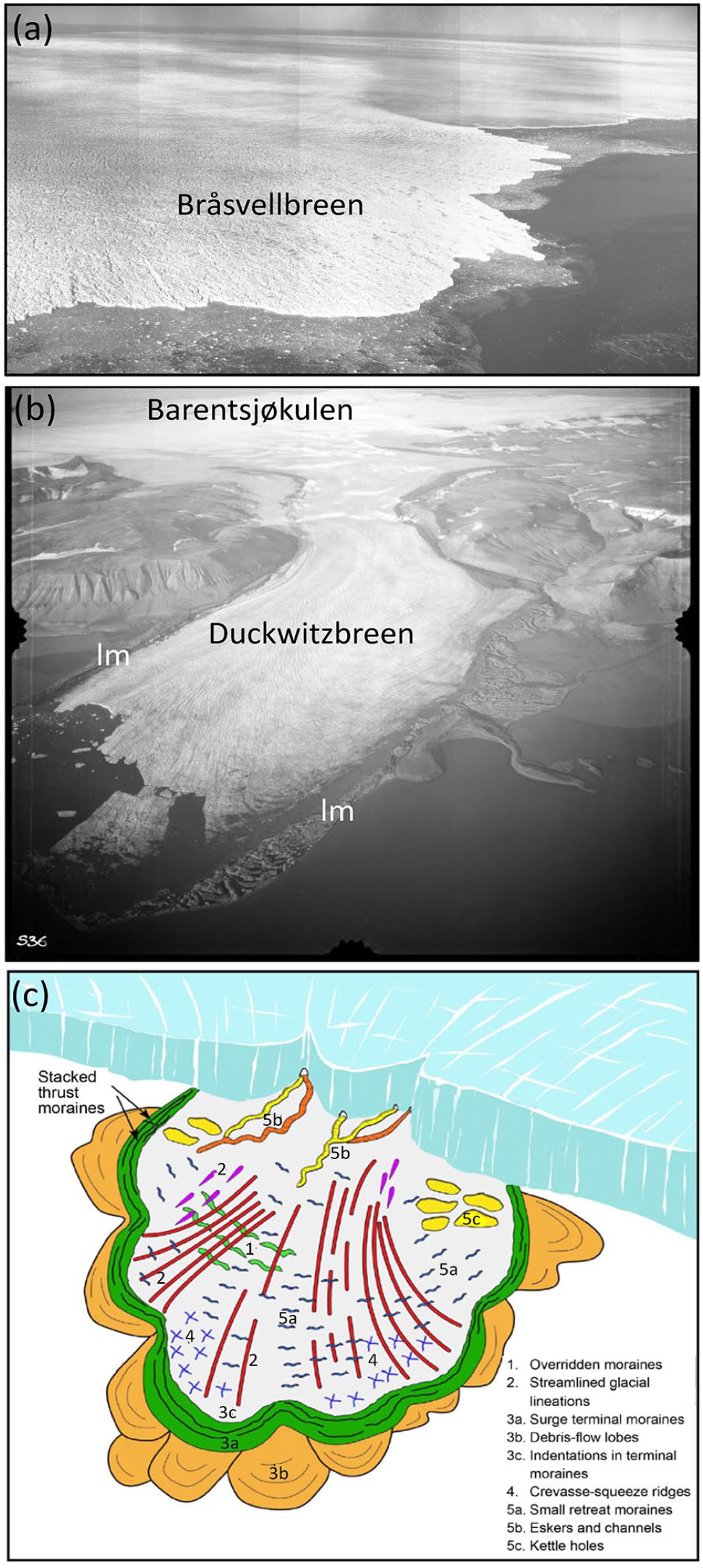
Evidence for recent surges of tidewater glaciers in northeastern Svalbard. (a) 1936 oblique aerial photograph of Bråsvellbreen, a drainage basin of Austfonna on Nordaustlandet (© Norsk Polarinstitutt). (b) 1936 oblique aerial photograph of Duckwitzbreen on Barentsøya (© Norsk Polarinstitutt). lm is lateral moraine. (c) A simple landform-assemblage model for tidewater glaciers surging into open-marine settings, developed from multibeam echo-sounder data from offshore of northeast Svalbard.
The recognition of a characteristic suite of surge-related landforms in the high-latitude marine record is also important when attempting to identify past glacier advances that may not be linked directly to climate change (Dowdeswell and Ottesen, 2016; Flink et al., 2015; Ottesen and Dowdeswell, 2006; Ottesen et al., 2017). Key submarine glacial landforms indicative of surging into marine waters, summarised in Figure 8c, include: mega-scale glacial lineations and other streamlined landforms; large terminal moraine ridges, sometimes with indented ice-proximal slopes, and associated lobe-shaped debris flows; isolated areas of crevassed-fill ridges; meltwater-related eskers and channels; annual retreat ridges; and crater-like kettle holes (Figures 2, 3 and 8c) (e.g. Dowdeswell et al., 2016a, 2016b; Ottesen et al., 2017). At individual glaciers, not all these features may be present and it is the assemblage of landforms that is diagnostic of surge activity (Dowdeswell and Ottesen, 2016; Ottesen and Dowdeswell, 2006; Ottesen et al., 2008, 2017).
Many of the larger tidewater glacier advances recorded in the marine-geophysical record of northeastern Svalbard appear to be of surge-type, based on both the submarine geomorphological-assemblage data and direct observations of glacier surges in the aerial photographs and satellite imagery acquired from the 1930s onwards (e.g. Hagen et al., 1993; Jiskoot et al., 1998; Lefauconnier and Hagen, 1991; Liestøl, 1969; Ottesen et al., 2017; Schytt, 1969). These glaciers and the supporting datasets that enable their identification as probable surge-type tidewater glaciers are listed in Table 1.
Conclusion
It is important to use offshore marine-geophysical data, especially in the form of multibeam echo-sounding, when attempting to map tidewater glacier and marine ice-cap extent during the recent past. This is especially so in open-marine settings, where fringing subaerial lateral moraines on fjord walls cannot be used to infer past terminus positions. Without such submarine geomorphological evidence, it is very difficult to estimate the extent of advances of marine-terminating glaciers over either the past few centuries or during the longer Holocene period since regional deglaciation from the late Weichselian full-glacial Svalbard-Barents Sea ice sheet.
It appears that attempts to reconstruct the ‘Little Ice Age’ extent of ice on Svalbard have encountered problems in specifying the area covered by tidewater glacier advances at this time (Martin-Moreno et al., 2017). Our paper brings together the marine geophysically measured recent extent of over 30 marine-terminating glaciers and ice caps in eastern Svalbard for the first time (Figures 2–6, Table 1). An absence of marine-geophysical data often leads to underestimation of the enlarged recent ice extent relative to today by about 40% for eastern Svalbard (excluding southeastern Austfonna). The recent changes in tidewater glacier extent we have measured in northeastern Svalbard amount to 1753 km2 or about 5% of the total modern ice cover of Svalbard (Figure 6). This reduction in ice extent is likely to have taken place mainly since the end of the ‘Little Ice Age’ and is sometimes related to the recent advance and subsequent retreat of surge-type glaciers.
The assemblages of well-preserved submarine glacial landforms inshore of recently deposited terminal moraine systems, combined with aerial-photographic and satellite-based observations available since the 1930s, provide evidence on whether any given advance is a result of surge activity or a simple response to climatic cooling events such as the recent ‘Little Ice Age’ (Table 1).
Care needs to be taken in ascribing ages to terminal moraines systems in Svalbard, in both the marine and terrestrial realms. It has been assumed that moraine ridges within a few kilometres of modern ice fronts usually represent either a ‘Little Ice Age’ maximum advance (e.g. Mangerud and Landvik, 2007; Martin-Moreno et al., 2017) or are related to surge activity over a similar period (e.g. Ottesen et al., 2017). This chronology is often the case on Svalbard, and, in the marine environment of eastern Svalbard, this timing can often be confirmed by reference to early historical maps and aerial photographs (Lefauconnier and Hagen, 1991; Ottesen et al., 2017). Older terminal moraines do exist, however, as shown by the substantially older Holocene radiocarbon-derived ages of the outermost submarine terminal ridges in Vaigattbogen and Mohnbukta in eastern Spitsbergen (Flink and Noormets, 2018; Flink et al., 2018), and recent 10Be and radiocarbon dating of Holocene moraine ridges on land in southern and northeastern Spitsbergen (Farnsworth et al., 2018; Phillips et al., 2017).
Footnotes
Acknowledgements
We thank the Norwegian Mapping Authority (Kartverket) Hydrographic Service for granting access to their multibeam swath-bathymetric datasets from northeastern Svalbard and Norsk Polarinstitutt for the use of their vertical and oblique aerial photographs. Collection of multibeam bathymetry from the RRS James Clark Ross was supported by a UK Natural Environment Research Council grant (NER/T/S/2003/00318) to JAD. Professor JO Hagen is thanked for reading and commenting on the manuscript along with Professor Chris Stokes and a further anonymous referee.
Funding
The author(s) received no financial support for the research, authorship and/or publication of this article.