
Abstract
The natural environment and prehistoric human activity in the Holocene floodplains of the Low Volga River and in the southern Urals are important research objects in geomorphology, soil science and archaeology. The alternating sequences of soil-alluvium sequences represent a sedimentary archive with chrono-stratigraphic records of human land use, sediment accumulation and soil formation. The central floodplain of the Derkul River (western Kazakhstan) was studied using the multiproxy approach to investigate the soil-alluvium sequence dating from 8000 years ago until the present and containing a buried Stagnic Fluvic Phaeozem. Alluvial deposition began with stream sedimentation in the early Holocene, followed by a prolonged period of soil formation under low water conditions (7.5–5.7 ka cal year BP). Humans started habitation the floodplain in 6.6–5.7 ka cal year BP. Increased atmospheric precipitation in 5.7–3.4 ka cal year BP accelerated alluvial sedimentation. Soil formation followed the synsedimentation model. Conditions for the stationary land use by humans in the floodplain were less optimal. In 3.4–2.1 ka cal year BP, alluvial sedimentation was less pronounced, and solonetz carbonated soils were formed, reflecting increased climate aridity and continentality. Humans returned to the floodplain area, but in 2.1–1.9 ka cal year BP, the flooding frequency increased, and in 1.9 ka cal year BP, the surface of the floodplain passes to function in a high floodplain. Thus, synsedimentation formation resumed, with colluvium discharge from the adjacent hills being the main source of material input.
Introduction
Alluvial deposition often includes buried soils and/or layers with pedogenic features at different floodplain terraces. Investigation of such objects allows reconstructing stream process dynamics and to obtain spatio-temporal patterns of floodplain formation over the entire Holocene (Glasko and Alexandrovskiy, 2015)
River floodplains have been always attracting human settlements by constantly providing fresh water and ample resources for hunting and fishing. Thus, in soil-alluvium sequences one can find cultural layers, providing rich information about human activity over the Holocene in the corresponding chrono-stratigraphic layers.
High frequency of river flooding results in accelerated sedimentation and land surface destabilisation, thus making floodplains not very comfortable and practical environments for stationary land use by humans; vice versa, low frequency of flooding, with relatively long periods of soil formation, provides humans with a possibility to use the most fertile soils. Consequently, the diagnostics of alternating stages of sedimentation and pedogenesis, with the aim to establish the time frame of human development on the floodplain, is equally important for geomorphology, soil science and archaeology.
Geoarchaeology studies on alluvial depositions represent a quite common means of integrating archaeology with natural sciences (Aleksandrovskii, 2004; Aleksandrovskii et al., 1987; Brown, 1997; Deckers and Riehl, 2007; Goldberg et al., 2001; Krenke et al., 2014; Velichko et al., 2014; Vorobieva, 2010; and others). In the Volga-Irtysh interfluvial area, archaeologists often notice topographic and stratigraphic relatedness of Mesolith-Eneolithic archaeological sites with floodplain areas (Kalieva and Logvin, 2017; Yudin, 2012; Zaibert and Potemkina, 1981; Zaibert et al., 2012; and others) however, most often, such sites have been studied only by archaeological methods without combining the latter with the methodology of natural sciences. In Kazakhstan, so far, there has been one exception, namely the study carried out at the Derkul 1 archaeological site (51°07′32.4″ N, 50°13′12.4″ E), which is located on the left bank of the River Derkul central floodplain, 80 km west of Uralsk City in western Kazakhstan (Figure 1(a)–(c)). The study of the deposited layers in the site showed their complex structure (Figure 2), necessitating more detailed studies using common methods such as lithology, soil science and radio-carbon dating.
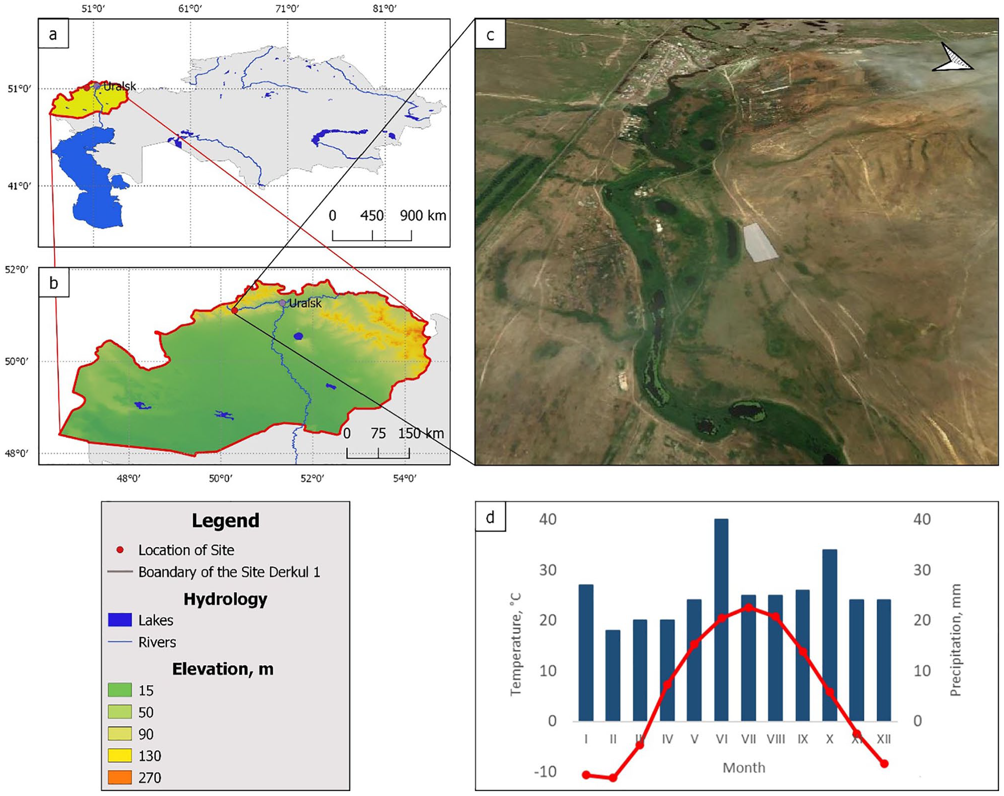
Location of the Derkul 1 site in western Kazakhstan: (a) overview map showing the study area, (b) location of site of Derkul 1, (c) 3D satellite image (Bing images) of the Derkul river floodplain and (d) climate diagrams for Taskala meteorological stations (51°06′27″N, 50°17′34″E; H = 74 m) showing monthly temperature and precipitation (Baisholanova, 2017).
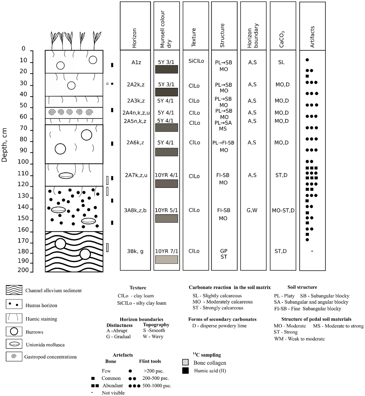
Morphology of the soil-alluvium sequences and soil sampling scheme for 14С dating.
The overall aim of the study was to reconstruct the stages of the soil-alluvial sequence formation in the Derkul River central floodplain, correlating the established stages with the known periods of human activities in the area.
Materials and methods
Regional setting
The study area is located in the hilly watershed between the Ural and Volga Rivers, that is, in the Obshchy Syrt. The area is composed by sediment deposits of the Jurassic age. In the Pleistocene the area functioned in subaerial conditions and was not affected by flooding from the transgresive basins of the Caspian Sea (Yanina et al., 2018).
Along the southern areas of the Obshchy Syrt there runs the Derkul River with its source at the footslope of Mount Ichka (280 m). The river is a secondary tributary of the Ural River and gets its water from the atmospheric precipitation and the groundwater. The river dries out during the lowest water-level period, in some places represented just by a chain of reaches. The flooding usually occurs in spring.
The River Derkul floodplain area, where the archaeological site is located, features even relief with a slight incline from the bedrock bank towards the riverbed and is situated 4 m above the low-water level (high floodplain), at an absolute elevation of 80 m above sea level. The middle floodplain is traversed by noticeable paleo riverbeds, following the direction of the current one and providing a specific relief of parallel small hills (Figure 1). Some residual features of the first river bed of the Derkul River, where the archaeological site is located, can be distinguished in the area stretching from the Birlik settlement borders along the bedrock bank to the sharp turn of the current river channel to the north. The climate is classified as moderately continental dry. The average temperature in January is −10.6°С (Figure 1(d)); the snowpack cover lasts on average for 142 days. The average temperature in July is +24С. Yearly average temperature is estimated as +5.8°С, with an accumulated active (⩾10°С) temperature sum of – 2938°С per year. Average yearly precipitation exceeds 300 mm, over the warm period, that is, July–October, ca. 200 mm are reached, with maxima in June–July and October. The moisture coefficient in the region, according to N.N. Ivanov, is 0.6–0.8 (Baisholanova, 2017).
The vegetation in the region is represented by sheep fescue (Festuca ovina) and feather grass steppes in the high floodplain and bedrock bank areas and by mesophytic meadows in the narrow stretch of the low floodplain of the current river bed, as well as mire plant assemblages in interhillock sites (paleo river bed).
Archaeological record
The Low Volga area, where the western territories of Kazakhstan belong to geographically, is an archaeologically complex and diverse region. This was especially true at the end of the Stone Age. In the early Eneolith, some Eneolithic (Near-Caspian, Khvalyns, Samara and Altatin) and late Neolithic cultures coexisted in the Low Volga area. However, no Neolithic or Eneolithic archaeological sites have been found in western Kazakhstan, except for small settlements in the Ryn Desert and Mangystau territories (Astafiev, 2014; Ivanov and Vasiliev, 1995). The finding archaeological sites in the late 1980s, dating back to the late Stone Age, allowed to assume an eastward expansion of the area of Neo-Eneolithic cultures of the Low Volga region. Earlier, the Derkul 1 site was examined in 1991 (Malov, 1988, 2008; Morgunova, 1991). In 2018 the study of site Derkul 1was resumed.
Field methods
Morphologic and pedogenetic studies of the 2-m thick soil-alluvium sequence, performed during field examination of the site, allowed classifying soil genetic horizons and sedimentary layers in accordance with the World Reference Base (WRB) for soil resources (2015) and the Guidelines for Soil Description (Guidelines for Soil Description, 2006). The soil was identified as Sodic Eutric Fluvisol (Loamic, Protocalcic, Profundihumic), and below it (at 120–180 cm) was a buried Endocalcic Stagnic Fluvic Phaeozem (Loamic, Sodic) (Figure 2).
For basic soil analyses, soil samples were collected every 5–10 cm within the soil genetic horizons. For microbiomorphic analysis, soil samples were collected from the lower 1–2 cm of every 5-cm increment. For radiocarbon dating, soil samples were collected from each humus horizon at its upper or lower boundaries in case a horizon was thick, or at the upper boundary in case a horizon was thin. Animal bones for radiocarbon dating were collected according to their stratigraphy.
Soil colour was assessed in air-dried soil samples according to Munsell scale (Munsell Soil-Color Charts with Genuine Munsell Color Chips, 2019).
Soil physical and chemical analyses
Grain-size analysis for fine particles (<2 mm) was performed via the conventional pipette method with sodium pyrophosphate pretreatment (van Reeuwijk, 2002) to distinguish texture classes. (Figure 3).
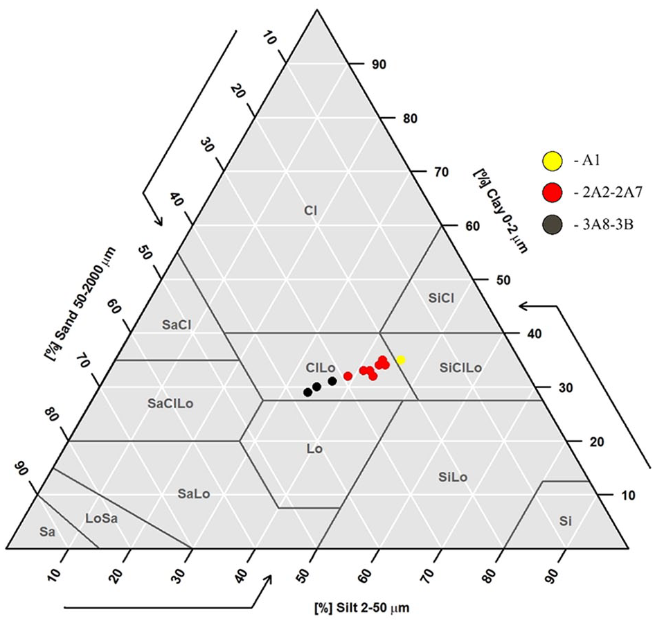
Ternary diagram illustrating textural variability of soil-alluvium sequences. The symbols used as in Figure 2.
For the diagnostics of the soil formation processes, the following soil properties were determined: soil organic carbon (SOC) content by potassium dichromate digestion; the qualitative composition of the exchangeable bases was estimated by extracting with Pfeffer reagent (0.1 M NH4Cl + 70% C2H5OH) and then by atomic absorption spectrometry; pH in soil: water suspension (1:5) was measured potentiometrically; and calcium carbonate content was measured using a Bernard calcimeter in sealed vessels with rubber stoppers after treatment with 10% HCl solution (Vorobieva, 2006).
To reconstruct the paleoclimatic conditions of soil formation, the following properties of soil humus profiles were determined: the composition of humus substances according to Ponomareva and Plotnikova (1980) and the H:C atomic ratio in humic acids (Dergacheva et al., 2012).
Total organic and inorganic phosphorus levels were measured (Holliday and Gartner, 2007; Saunders and Williams, 1955).
Microbiomorph analysis
The distribution of the opaline microfossils (microbiomorphs) was studied along the soil-alluvium profile. The qualitative and quantitative characteristics of the distribution allow the reconstruction of the plant community and the soil moisture regime, as well as the identification of alternating erosion and accumulation stages during soil profile formation (Gavrilov and Khabdulina, 2018; Gavrilov et al., 2018; Golyeva, 2001, 2008).
Samples for microbiomorph analysis were dried and subjected to standard procedures (Piperno, 1988). After treatment with a hot 30% H2O2 solution and 10% HCl, samples (approximately 50 g) were separated from sand and clay, and subjected to flotation in heavy liquid (cadmium iodide and potassium iodide solution with a gravity of approximately 2.3). After centrifugation (1500 rpm for 20 min), the floating phytoliths were collected in a tube, washed several times with distilled water, and studied under an optical microscope with 300× magnification. Phytoliths were counted for the cover glass (24 mm × 24 mm) area.
The phytoliths were identified according to ICPN 2.0 (International Committee for Phytolith Taxonomy et al., 2019).
Archaeological stratigraphy and artefact dating
The archaeological stratigraphy of artefact locations within the studied soil-alluvium sequence was registered in the field. The number of artefacts was determined every 10 cm in two 8-m2 quadrate plots. The found artefacts were dated by the typological method and by their similarity with other artefacts found by digging in other, similar archaeological sites.
Radiocarbon dating and the age-depth model
To determine the 14С content in soil humic acids, a stepwise chemical treatment of soil to extract the so-called ‘labile and young humic acid fraction’ (HA I) was carried out by 0.1 N NaOH extraction. The stable humic acid fraction (HA II) fixed by soil minerals was extracted with the same extractant after decalcification (Chichagova, 1985). Soil radiocarbon dating was performed in HA II fractions. The date of the human settlement in the floodplain was established by 14С in the collagen of the animal bones. Radiocarbon dating was performed by acceleration mass-spectrometry (AMS) in the ‘Cenozoic Geoarchaeology’ Core Facility (Novosibirsk, Russia) and in the A.E. Lalonde AMS Laboratory (Ottawa, Canada). The radiocarbon dates were calibrated against the calibration curve IntCal13 (Reimer et al., 2013), and the age-depth model was obtained using the R software Bchron (Parnell et al., 2008).
Results
The results of the field work and laboratory analyses are presented from the deepest layers upward, according to the temporal sequence of the layer formation.
Soil macromorphology
The Fluvisol was represented by a stratified humus-containing layer ca. 1.2 m thick (А1-2А7, Figure 2). The entire profile was transformed by pedogenesis, although the lithogenic laminated structure is sustained throughout. The humus horizon is coloured light-grey (5Y 3/1-4/1), darkening downwards due to gleying in the profile bottom layer. The granulometric composition in the top part of the layer is silty clay loam in the 0–30 cm and clay loam below. The boundaries between horizons are abrupt and smooth.
The soil is saline and carbonated throughout the entire profile (moderately calcareous, disperse powdery lime). Down to 100 cm deep the profile preserved the passes dug by soil-dwelling animals, filled with humus material. At the depth of 50–60 shells of the freshwater gastropods can be seen, whereas at the depth of 100–120 cm one can find the shells of Unionida mollusca. The entire soil profile contains artefacts (stone tools, animal bones, splinters, ceramic fragments; Figure 2), which belonged to the people of Eneolyth, Bronze and Early Iron Age cultures. Judging by the content and composition of the artefacts, humans used the floodplain with different intensity.
Below the Fluvisol is buried by the Stagnic Fluvic Phaeozem (120–200 cm), that has a darker and thicker humus horizon with fine subangular blocky structure (3A8k,z,b, 120–160 cm) and a stagnic medium horizon (3Bkg, 160–200 cm). The Unionida mollusca shell can be found in the humus horizon, whereas one can see the passes of soil-digging animals in the B horizon.
Physical and chemical properties of soil
Soil texture profle showed a downward change in the relative abundance of sand, silt and clay (Figure 3). The buried Stagnic Fluvic Phaeozem (120–200 cm) has clay loam composition with 31%–37% of sand, 35%–37% of clay and 29%–31% of silt fraction. Fluvisol shows gradual decrease of sand fraction (22%–30%) and increase of clay (40%–46%) and silt (30%–35%) fractions. The depth of 0–30 cm displayed the textural shift from the clay loam to the silty clay loam.
The buried soil showed an accumulative type of SOM profile distribution, with 0.6%–0.9% in 3A8b and more than 0.4% n 3Bk,g horizons (Table 1). The current low SOC content was due to diagenesis.
Soil chemical properties.
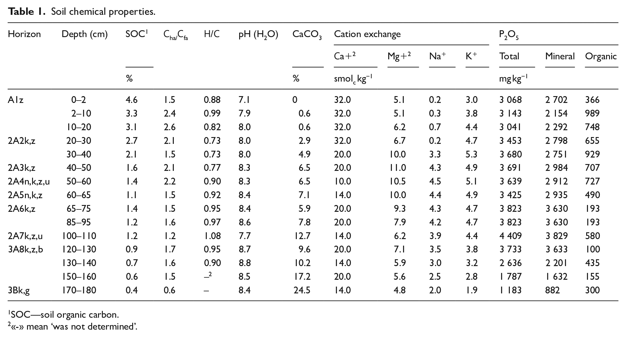
SOC—soil organic carbon.
«-» mean ‘was not determined’.
The ratio of humus acids characterised their composition as fulvic-humic (1.5–1.7) with a Н:С elemental ratio of 0.95 in humic acids. Soil: water suspension pH was alkaline, ranging from 8.4–8.7. The maximum pH value was found n the paleo topsoil and the minimum on the mineral paleo subsoil, correlating with the СаСO3 content. This can be explained by alkalinisation of the soil after its burial due to the leaching of calcium carbonates from the bone-bearing cultural horizon (2A7 at 100–120 cm) and their accumulation in the paleo humus horizon. The paleosol profile had ahigh (10%–24%) carbonate content throughout, with diagenetic solonetsisation from the 2А5 horizon.
The cultural bone-bearing horizon was identified as an anthropogenic layer, transformed by the humus-accumulating process (2A7k,z,u). The soil organic carbon content in this horizon was slightly higher than that in the paleosol humus horizon (3A8), which might be due to the additional input of carbon by humans: the fraction of soil organic phosphorus increased six times as compared to the upper part of the horizon 3A8b, supporting this assumption (Table 1).
In 2A7 the humic to fulvic acids ratio was lower (CHA:CFA = 1.2), whereas the humic acid Н:С ratio was higher (1.08) when compared with the 3A8b horizon The contribution of Na+, and Мg+2 and Na+ to the sum of exchangeable cations did not differ from that of the lower horizon, resulting from diagenesis. Soil phosphorus fraction analysis showed an increased organic phosphorus content (580 mg kg−1) in the bone-bearing cultural horizon, as well as an increased total soil phosphorus content as compared with the upper layer (4.409 mg kg−1), ranging from 3.041–3.823 mg kg−1 of dry soil.
The cultural horizon was buried under the pedogenically transformed alluvial depositions (2A6) of the clay loam composition. The chemical properties of 2A6 and 3A8b horizons were similar (Table 1).
Horizon 2А5 was characterised by decreased Са+2 contribution as compared with Mg+2 and Na+ contributions, as well as poor manifestation of silt illuviation, which is indicative of the solonetsic properties of the horizon.
In culture horizon 2А4, similar to the 2А5 horizon, Са+2 contribution to the sum of exchangeable cations was lower as compared with Mg+2 and Na+ contributions, but other solonetsisation features, such as specific structure, silt illuviation and alkaline pH, were not revealed.
In A1–2A3 (0–50 cm), SOC showed a gradual decrease from the upper to lower horizons of the surface soil, ranging from 1.6% to 4.6%. Humus acids ratio displayed a saw-like pattern, as the CHA: CFA ratio alternated between humic-fulvic or humate type of humus. The Н:С ratio revealed differences in the humic acid structure: in the 2A2–2A3 horizons, the aromatic structures prevailed over the aliphatic ones (0.73–0.77), whereas in the A1 horizon, the contribution of aromatic structures was lower (0.82–0.99).
In A1–2A3, Ca+2 ions were relatively more abundant among exchangeable cations. Soil reaction changed from neutral to alkaline (7.1–8.0), correlating with the СаСО3 profile distribution.
Microbiomorph analysis
Phytoliths, diatomic algae and sponge spicules were found in the microbiomorph assemblages obtained from the soil-alluvium sequence (Figure 4). The profile distribution of silica microbiomorphs displayed a gradual upward increase of phytolith-relative abundance as compared with diatomic algae and sponge spicules (Figure 5).
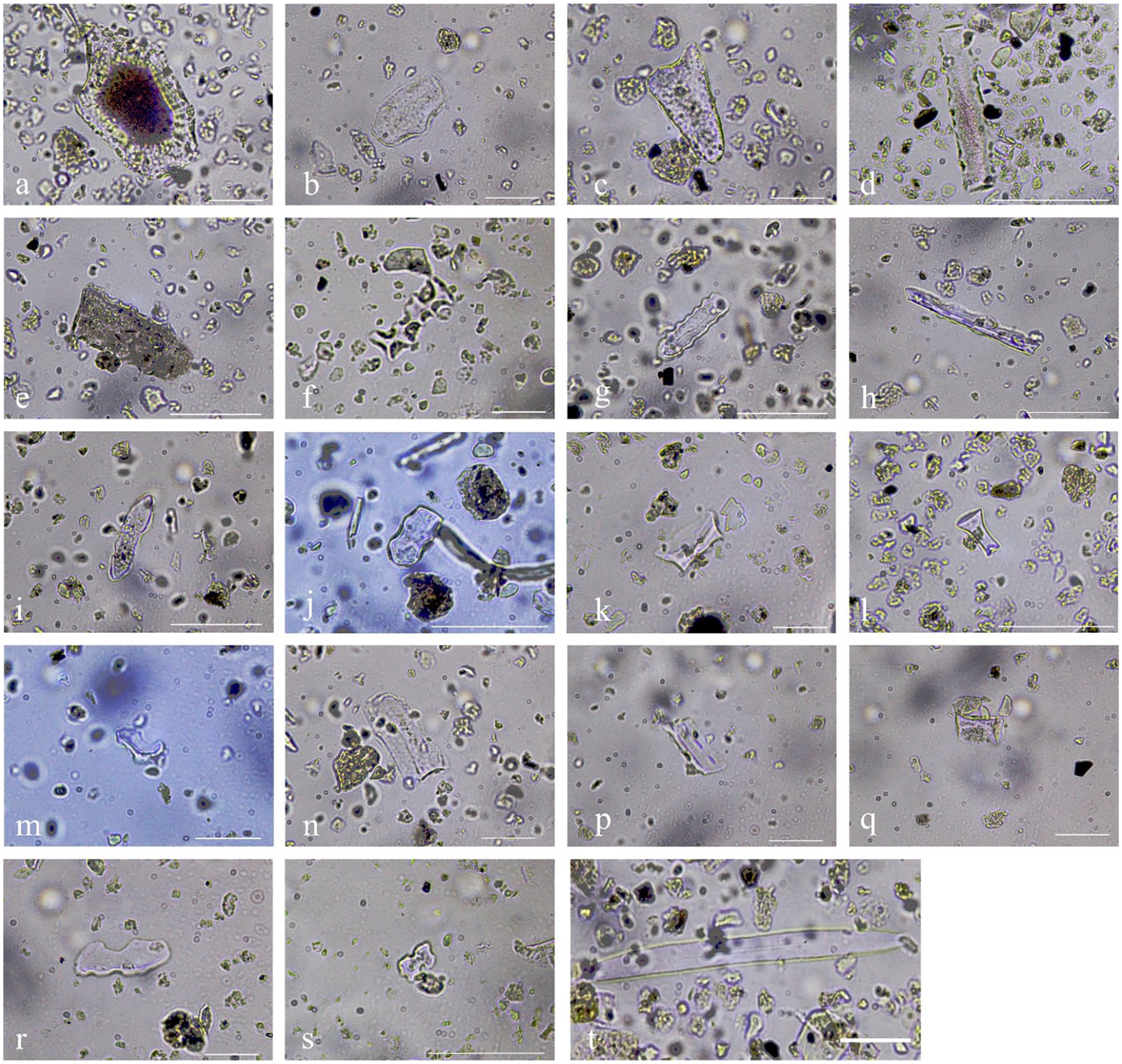
Micrographs of the silica biomorphs: (a) and (b) bulliform flabellate (Phragmites sp.), (c) carinate lanceolate, (d)–(f) elongate sinuate, (g)–(j) crenate, (k) trapezoid, (l) Rondel, (m) saddle, (n)–(q) blocky, (r) and (s) Bilobate and (t) sponge spicule. The bar indicates 20 µm.
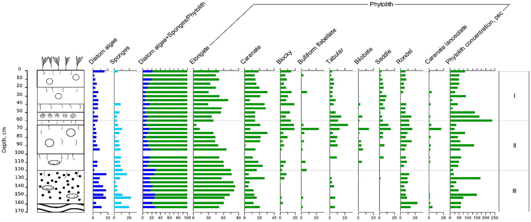
Morphology and microbiomorph profile of the soil (relative abundance, %). The symbols used as in Figure 2.
According to the phytolith analysis results, we distinguished three zones in the studied soil-alluvium sequence: 0–60 cm (Zone I), 60–120 cm (Zone II) and 120–170 cm (Zone III).
Zone III embraces the humus horizon of the buried soil (3А8). The phytolith assemblage indicated that meadow grasses played an important role in the phytocoenosis formation. The prevalence of the group was especially pronounced in the lower part of the humus horizon (Crenate), accompanied by Phragmites phytoliths (Bulliform flabellate). The phytocoenosis was inferred as consisting of reed, herbs and grasses. In the upper part of the humus horizon, sedge phytoliths (Cyperaceae sp., Saddle) and phytoliths (Poaceae sp., Blocky) specific for arid grasses (Poaceae sp., Blocky) were found. The total phytolith content was moderate and equitably distributed. The microbiomorph content peaked at depths of 130 and 150 cm.
Zone II embraces both the cultural layer (2A7) and the 2А6 horizon. Compared with Zone III, this zone had a lower content of diatomic algae and sponge spicules. The phytolith assemblages of Zone II had Phragmites phytoliths throughout the entire layer, with an upward increase of the ones derived from steppe (Tabular, Rondel) and arid grasses (Blocky) alongside with the sedge ones (Saddle).
The microbiomorph upward distribution was equitable, except for the depth of 90 cm, where the microbiomorph content increased.
Zone I also displayed the general tendency of decreasing contents of diatomic algae and sponge spicules and increasing phytolith content. The phytolith assemblages of Zone I, as compared with Zone II, showed equitable depth distribution of those from arid grasses (Blocky) and increasing relative abundance of those from steppe grasses (Tabular, Rondel). Overall, the microbiomorph distribution showed an accumulative pattern due to the relatively long-term span of soil formation and the decreased role of sedimentation processes in the layer formation. In the lower part of Zone I (2A4, 50–60 cm), the phytolith content was maximum in comparison to that of the other soil profile parts.
Radiocarbon dating
The radiocarbon dates, obtained using humic acids, in mature soils allow establishing only the mean residence time (MRT) of carbon in soils (Ivanov et al., 2009; Paul et al., 1997), thus determining the minimal layer of the soil burial and providing only a rough estimate of soil formation duration.
The paleosol (3A8–3B) was represented by a rather developed and differentiated profile, formed at least over the period of 1000 years. However, the relatively slow carbon turnover in the soil, alongside with its constant renovation during periods of site surface exposure, does not allow pinpointing the exact date of the soil formation start and the date of soil burial. The soil sample collected near the lower boundary of the humus horizon, that is, at 155–160 cm, allows estimating the minimal time of the soil formation start (Table 2). The date of the paleosol burial by alluvium deposition and the date of the end of the long-term stationary development of the floodplain can be limited to the 5.6–5.7 ka cal year BP time span, based on the 14С content in bone collagen of the NSKA-2386 bone artefact. Comparison of the 14С contents in NSKA-2386 and NSKA-2574 showed that the duration of the paleosol formation and its surface stabilisation may be estimated as 1700–1800 years.
Radiocarbon dating results.
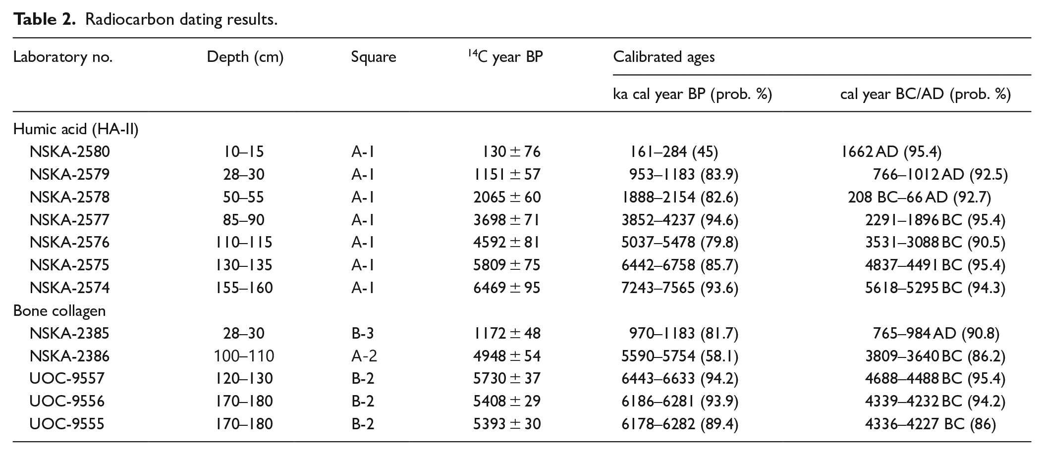
The results of the radiocarbon dating of animal bones, retrieved from different depths of the paleosol, suggested that the date of human settling in the floodplain ranges from 6.6 to 5.7 ka cal year BP. These dates agree well with the dates estimated for other archaeological sites in the region, that is, Algay and Oroshaemoye 1 sites (Kulkova et al., 2019).
The radiocarbon dating of humic acids reflects the mean residence time of carbon in soil, and often, such dates turn out to be more ancient than those estimated on the basis of archaeological findings. This can be very well seen when comparing the dates on NSKA-2386 and NSKA-2576 artefacts, retrieved from about the same depths. However, the dates obtained for a depth of 28–30 cm while analysing collagen and humic acids (II), that is, NSKA-2385 and NSKA-2579 samples, were estimated to be similar. This finding can be attributed to the slow renewal of soil carbon under sedimentation. The calculated mean accumulation rate of the sedimentation layer (Figure 7(j)) was estimated as 2 cm per 100 years at a depth of 20–30 cm. The estimate can be considered a threshold of the relative carbon turnover rate in synlithogenic soils: if the sedimentation rate is ⩾ 2 cm per 100 years, the radiocarbon dates are estimated as being more ancient due to soil formation duration, whereas if the sedimentation rate is ⩽2 cm per 100 years, the dates are close or equal to those obtained on the archaeological basis.
Archaeological stratigraphy
The digging (8 m2) produced more than 11,000 stone artefacts, of which 98.5% were made from the local quartzite-like sandstone, grey-yellowish or light-grey in colour. The sandstone deposits are located 1.0–1.5 km to the north of the site on the nearest hill.
The top layers preserved some scarce artefacts of the early nomads, such as a bead, most likely representing the Sarmat culture (2.8–2.2 ka cal year BP) (Figure 6(a)). The nearest burial mounds are located 1 km away to the north of the site.
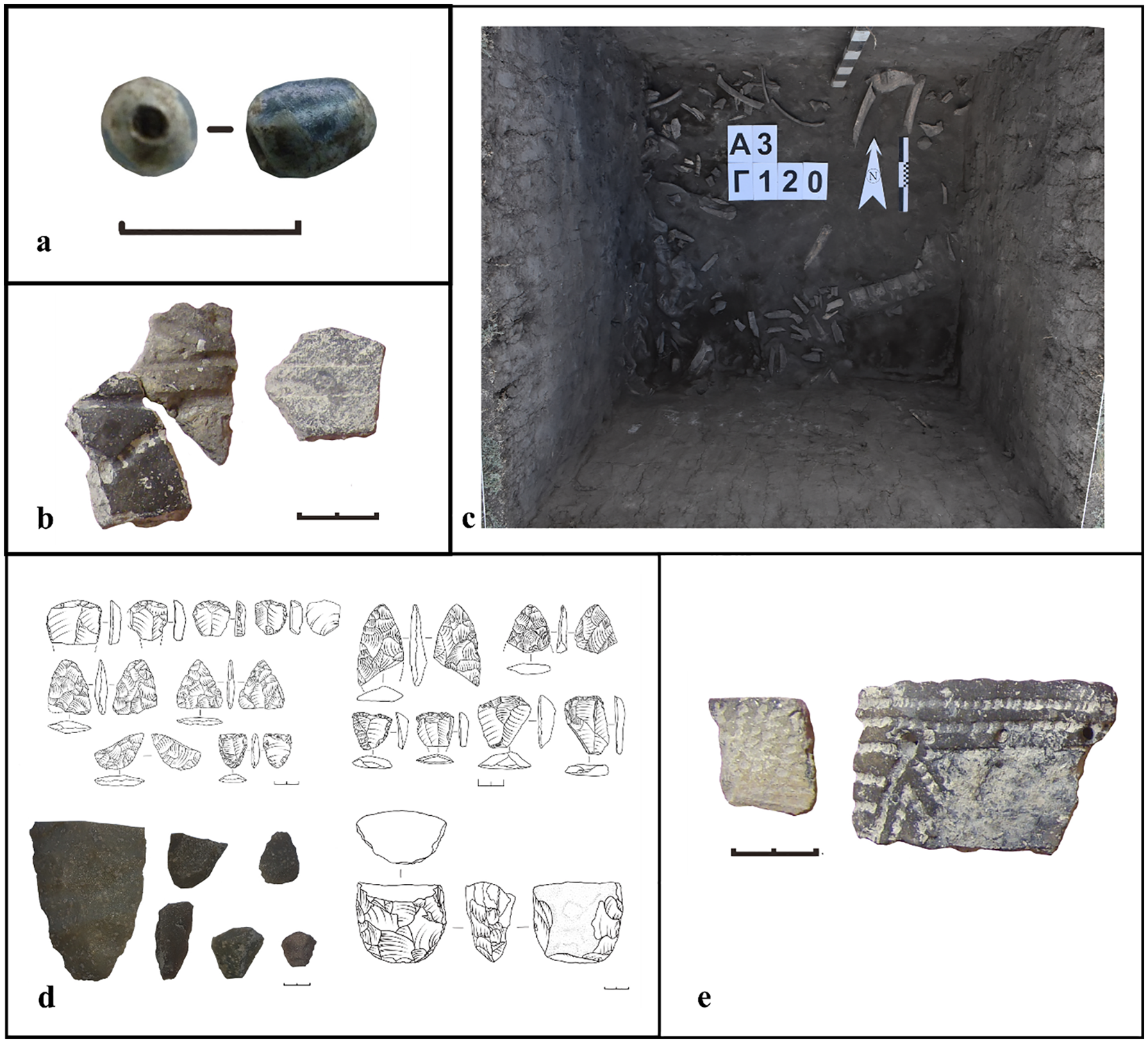
Archaeological findings: (a) bead of the Sarmat culture (10–20 sm, 2.8–2.2 ka cal year BP), (b) ceramics of Timber-grave culture (50–60 cm, 3.8–3.2 ka cal year BP); Caspian culture (100–120 cm, the 2nd half of 5.0 ka cal year BP), (c) concentration of animal bones in the cultural horizon (2A7), (d) bifascial tools, scrapers, nucleus and (e) ceramics.
The 60–70 cm deep layer recorded the 2nd stage of the site functioning was related to the representatives of the Timber-grave culture (Srubnaya culture, late Bronze Age). Certain ceramic fragments, so-called ‘corollary rims’, with specific sloping outlines and impressions on the top, are the diagnostic artefacts (Figure 6(b)). The population was involved in large- and small-scale cattle-raising and probably in floodplain agriculture, as a pick-like hoe was found at the site.
At the 100–120 cm depth the cultural layer (Figure 6(c)), rich in bone residues from the wild fauna of the steppe biome, that is, horse (Equus sp.), wild bull (Bos primigenius), antelope (Saiga tatarica) and pother mammals, according to P.A. Kosintsev attribution. The number of completed tools in this layer reached 14%–18% of the total number of stone tools artefacts, predominantly as a two-sided processed blade-,oval- and triangular shaped tips for arrows and spears, scrapes, cutting tools etc. The tools made by primary splitting were represented by one-sided one-area nuclei to make laminar chipping (Figure 1(d)). The ceramic fragments found during the excavation were mostly from the vessels with comb-sshaped, patching or pricking ornamentation, with admixture of crushed shells in the clay (Figure 1(e)).
From 130 down to 180 cm deep the frequency of finding tool and other artefact decreased to 4.2% of the artefacts from the quartzite-like sandstone and 9.5% of tools from the same material in the 130–140 cm layer, whereas in the 170–180 cm layer the respective values were 0.3 and 0.7%. The found tools were represented mostly by the bifascial tools, scrapers, as well as their chips and fragments from secondary processing. Ceramic fragments were not abundant, mostly as vessel bodies with comb- or finger-made ornaments. Bone residues were much more rare.
Specific source material of quartzite-like sandstone, prevailing large-sized artefacts with two-sides processed, as well broad laminate chips and blades, scrapers, the presence of ceramic fragments resembling those of the Caspian culture, together with some similarities to archaeological sites such as Oroshaemoe 1 at the Big Uzen River, Kuznetsovo 1 at the Derkul River, Osinki 1–2 in the area of the upper course of the Big Chalykla River, allow us to ascribe the cultural layer at 100–120 cm (2A7k, z, u) to the Caspian culture (the 2nd half of 5.0 ka cal year BP) of the Low Volga region and, specifically, to its easternmost areas (Yudin, 2012). Farther eastward, the Caspian artefacts are unknown. The Derkul 1 site was a long-term settlement with some workshop features, where the primary processing of stoneware took place.
Discussion
While reconstructing the sequence of events during soil-alluvium sequence formation in floodplains, one should take into account all the factors involved in the process, namely alluvial and colluvium sedimentation duration and rates, duration and specifics of soil formation periods, the time span of human settlement and the development of the floodplain. Each of these factors is characterised by specific rates and may have been combined in action. The period of floodplain levels (high, medium and low) formation was longer (n:·103–104), whereas soil formation occurred during shorter time spans (n:·102–103); intervals of human occupation of the soil surface was even shorter (n:·10–102).
Sedimentation and soil formation
Sedimentation and sediment deposition and accumulation are the most important factors determining duration and the nature of soil formation in a floodplain, as well as the feasibility of human occupation of floodplain areas.
The genesis of the parent rock material for further pedogenic transformation and the specific characteristics of sedimentation are commonly determined on the basis of particle size composition, that is, substrate granulometry, and its distribution throughout the layer profile. The water flow transports and segregates the particles, with transportation and segregation processes depending of the water amount and solid input, water flow turbulence and flow rate. For instance, when the water flow rate is 0.162 m s−1, the stream moves fine sand particles over the bottom; when the rate increases up to 0.216 m s−1, the stream moves coarse sand particles, while at 0.975 m s−1, it moves pebbles (Kizevaltor et al., 1981). Farther from the riverbed, the flooding waters decrease their rate and, due to this, the particle separation process begins, depositing larger particles near the riverbed and finer particles near terraces.
Granulometric composition, sediment accumulation rate and the structure of soil-alluvial sequence in the studied layer (Figures 2, 3 and 7(j)) allowed revealing three stages in the River Derkul hydrological regime: (1) river alluvium formed under a relatively high sedimentation rate, resulting in sand and clay fraction accumulation at 120–180 cm; (2) floodplain alluvium formed due to decreased water flow rate and accumulation of sand and silt in 40–120 cm; (3) colluvium-alluvium layer with sand and silt fractions prevailing (0–40 cm).
Changes in the sedimentation environment should be considered as determined by the natural development of the floodplain, when the alluvial layer under the flooding regime increases ‘upwards’ and is gradually flooded less often during high water, with a low–medium–high floodplain sequence. The features of the paleo riverbeds, which can be seen in the central floodplain of the River Derkul, allow to relate the revealed lithology specifics to the stages of their functioning: the first stage was a paleo riverbed, functioning close to the current left bedrock river bank; the second stage was a paleo riverbed lower than the Birlik settlement between the first paleo riverbed and the current one; and the third stage was represented by the current riverbed (Figure 1).
Another factor driving the alluvial sedimentation development is represented by a combination of erosion and denudation processes in the areas adjacent to floodplain terraces. Some researchers (e.g. Aleksandrovskii, 2004) believe that intensification of these processes depends on the periods of deep soil freezing, resulting in lateral surface flow during snow melting in spring.
To identify pedogenesis and sedimentation cycles on the basis of the age-depth model, we calculated the mean rates of layer and horizon formation (Figure 7(j)). Aleksandrovskii (2004) suggested the following grouping of alluvium accumulation rates (pedolithocomplex formation rates): (1) at rates higher than 25 cm per 100 years, solely alluvium accumulation takes place, without pedogenesis; (2) at the rates of 10–25 cm per 100 years, alluvium accumulation takes place, accompanied by some pedogenesis; (3) rates of 3–10 cm per 100 years result in the formation of soddy layers in synsedimentation soils; (4) the rates of 1–3 cm per 100 years result in the formation of soils with well-developed humus horizons (soddy and meadow soils); (5) at the rates of 1 cm per 100 years, only zonal soil formation occurs when soil develops in ‘down’.
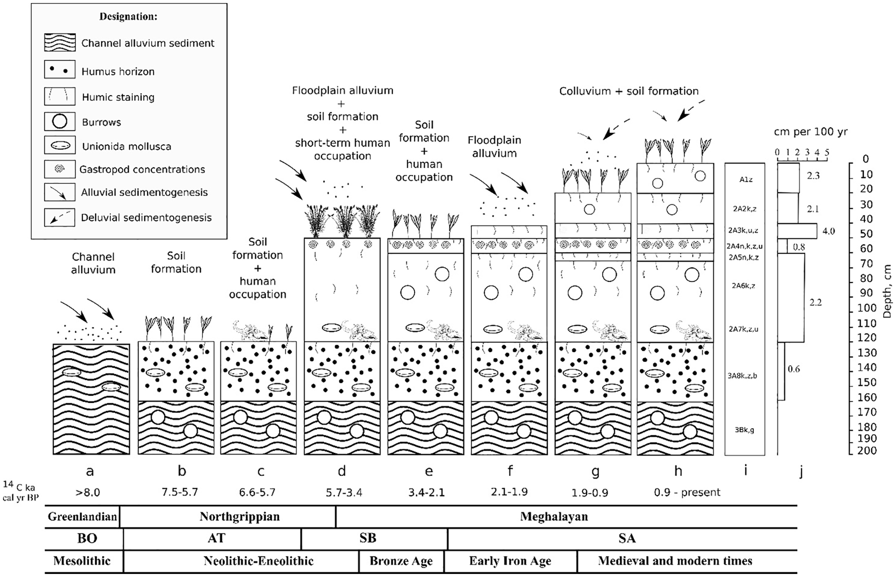
Pedosedimentary reconstruction of the Derkul River floodplain. Symbols used: (a)–(h) soil-alluvium sequence formation and floodplain use by humans, (i) soil profile and (j) sedimentation rate (cm per 100 years).
Based on the reconstructed mean formation rates of the studied soil-alluvium sequence, and in accordance to the grouping specified above, the sediment depositions of the central floodplain of the River Derkul represent the cyclites of the synsedimentation horizons, and horizon development as a result of long-term soil formation in an environment with alluvium formation slowed down.
Soil formation and human activity
Currently, there are plenty of data obtained during soil and archaeological studies concerning soil evolution and soil formation environment in the Holocene in the Low Volga region and the southern Urals (Khokhlova et al., 2008, 2019, 2010; Kulkova et al., 2019; Ovchinnikov et al., 2020), and high-precision patterns of paleofluvial process activity have been constructed (Panin and Matlakhova, 2015). However, studies of soil-alluvium sequences, with the aim of obtaining an insight into the genesis and environment evolution, are few (Ivanov et al., 2019).
The buried Stagnic Fluvic Phaeozem (120–180 cm) formed in the low floodplain 7.5–5.6 ka cal year BP (Figure 7(b)) and is synchronous to the phase of low activity of fluvial processes according to the A. Panin and E. Matlakhova scheme (2015). Microbiomorph analysis showed that at the initial stages of its formation, the soil functioned in the more humid conditions due to the high level of groundwater, propped up by the river. The plant community consisted of reeds, herbs and grasses. Later, the conditions became more arid and continental, resulting in decreased flooding and a lower groundwater level. The plant community at this stage can be reconstructed as a mesophytic meadow with sedges and grasses. The 3Bk,g horizon displayed paleo molecasts, filled by soil from the humus horizon. Khokhlova et al. (2018, 2019) and Ivanov et al. (2019) also reported an increased aridity and continentality of the climate during this period. The H:C ratio in humic acids can be regarded as the most informative property for reconstructing thermal and hydrological conditions of humus formation. For soils in the southern Urals, it was reported that a humus formation environment at the H:C ratio of 1.06 ± 0.09 corresponded to forest biomes, that of 1.02 ± 0.06 to the forest-steppe, that of 0.85 ± 0.04 to steppe and that of 0.70 ± 0.06 to the dry steppe (Dergacheva et al., 2012). Taking into account the accumulative catenary position of the paleosol and its additional surface and groundwater supply, the elemental H:C ratio in humic acids (0.95, at 120–130 cm) resulted from the locally optimal warm and moist conditions of humus formation. Radiocarbon dating on the bone collagen of the artefacts retrieved from the 110–180-cm showed that humans developed the floodplain area for a rather long period of 6.6–5.7 ka cal year BP (Table 2). Such a long time span should have led to the formation of a rather thick cultural horizon, which, however, was not visible in the paleosol profile. Comparison of this time interval with the time of paleo humus horizon development (7.5–5.6 ka cal year BP), together with profile distribution of microbiomorphs, suggested the possibility of alluvial material input that buried the paleo surfaces. This hypothesis needs further research to establish archaeological stratigraphy in the 3А8 horizon. At the Turganik settlement site 5.8–5.9 ka cal year BP (layer VI) and 5.7–5.2 ka cal year BP (layer V), Khokhlova et al. (2019) found evidence of catastrophic flooding events, which buried the cultural layers. Other researchers.(e.g Ovchinnikov et al., 2020), based on the pedosedimentary sequence at the Oroshaemoye 1 settlement (170 km to the south-west from Derkul 1 at the high bedrock bank of the Uzen River), identified several stages of soil formation and sediment accumulation for the time spanning 7.8–6.3 ka cal year BP, namely an aridisation period (7.8–7.0 ka cal year BP) with increased sediment accumulation; relative climate humidisation (7.0–6.6 ka cal year BP) was followed by the slow-down of soil formation and increased sediment accumulation (6.6–6.3 ka cal year BP).
According to the soil phosphorus content and archaeological digging, the period of active floodplain development by humans was 5.6–5.7 ka cal year BP (Figures 2 and 7c, Table 1).
Formation of the second Derkul paleo riverbed finished about 5.7 ka cal year BP. The first paleo riverbed, at which the Derkul settlement started, became a backwater. This time period coincided with increased atmospheric precipitation and intensified alluvial sedimentation (2–4 cm per 100 years) (Figure 7(d)), with pedogenesis occurring under aquatic or subaquatic conditions. This situation resulted in a specific qualitative composition of phytolith assemblages of the 2А6 horizon (65–100 cm), with an abundance of Phragmites phytoliths.
The 2А7 horizon represents pedogenically transformed alluvium, which buried the surface of the paleosol (cultural layer, 3A8).
The properties of the 2А6 horizon (5.7–3.4 ka cal year BP) complied with the synsedimentation stage of the soil-alluvium sequence, whose surface was often flooded by the river. The total phytolith content was moderate and equitably distributed, which is confirm for synlithogenic stage of horizon formation. As a result, the floodplain was hardly suitable for stationary use by humans, who were able to use the area only for short periods. The stationary settlements of the period should therefore be sought in floodplain areas at higher elevations. Archaeological digging showed that the artefacts, being randomly distributed throughout the horizon, were often horizontally oriented, thus marking the paleo surfaces.
The distinguished stage falls on the phases of high (5.5–4.6 ka cal b2k) and low (4.6–3.5 ka cal b2k) activity of fluvial processes in the Lower Volga region (Panin and Matlakhova, 2015). According to the results of our study, the stage of low alluvial sedimentation (> 1 cm per 100 years) refers to the period 3.4–2.1 ka cal year BP (Figure 7(e)). At this stage, the soil-alluvial stratum was formed by a combination of synsedimentation and superimposed development of soil formation. Soil formation proceeded under the conditions of capillary-hydromorphic uplift of weakly mineralised waters, a weak manifestation of the saltification process and possible hydrogenic accumulation of salts in the lower part of the profile under arid conditions. Some evidence of human activity (stone chips) were found at the depth of 40–50 cm.
The time span ranging from 2.1 to 1.9 ka cal year BP (Figure 7(f)) saw intensified alluvial sedimentation. This stage falls into the third phase of activation of fluvial activity, - 3.5–1.9 ka cal b2k (Panin and Matlakhova, 2015). The mean rate of synsedimentation horizon (2А3–2А4) formation was estimated as 4 cm per 100 years.
About 1.9 ka cal year BP (Figure 7(g)) there was a decrease in the frequency of flooding events, apparently due to the initiation of the current Derkul River channel and the finished functioning of the second paleo riverbed. The surface area became a high floodplain. The elemental H:C ratio of humic acids (0.73–0.77) confirmed the beginning of the second arid stage, which ended late in the first millennium AD.
The time span ranging from 1.9 ka cal year BP until present (Figure 7(g) and (h)) has been experiencing synsedimentation (2 cm per 100 years) formation of the layer, when the main source of material was colluvial discharge from adjacent hills. The grey humus-carbonated horizons (0–50 cm) were formed under a fluctuating arid climate.
Conclusion
The high floodplain of the River Derkul is composed of soil-alluvium deposits of the Middle and the second half of the Holocene. These deposits contain information about the chronological sequence of soil formation conditions, the development of the river valley and the history of human activity of the floodplain area.
The study established that the start of the floodplain sediment layer formation took place due to stream sedimentation in the early Holocene (>8 ka year BP). It was followed by the long period of soil formation (7.5–5.7 ka cal year BP) resulting in the Stagnic Fluvic Phaeozem, developed in the low floodplain (120–180 cm). The soil functioned under relatively optimal moist and heat conditions. At its early stages, the environment was mostly humid, but during the period of human use, it became arid, which is evidenced by molecasts, carbonate accumulation and phytoliths of arid grasses.
Humans started to develop the floodplain area for occupation in 6.6–5.7 ka cal year BP. The most intensive stage occurred in 5.6–5.7 ka cal year BP: the depth of 100–120 cm produced most of the artefacts and showed an increased phosphorus content.
In ca. 5.7 ka cal year BP, the increased atmospheric precipitation brought intensified alluvial sedimentation, which took place until 3.4 ka cal year BP. Humans were able to use the floodplain area only for short terms.
In 3.4–2.1 ka cal year BP, alluvial sedimentation decreased, and solonetz soils began to develop as a result of increased aridity and continentality. Humans once again returned to the area.
The frequency of flooding events increased in 2.1 ka cal year BP and decreased again in 1.9 ka cal year BP. The floodplain surface began its functioning as a high floodplain. The period of synsedimentation formation of the layer continued, with colluvium from the adjacent hills being the main source of material input. Grey humus-carbonated soil horizons (0–50 cm) were formed under a fluctuating climate aridity.
Footnotes
Acknowledgements
The authors sincerely thank Professor Alexander L. Alexandrovsky for providing valuable comments on earlier drafts of this manuscript and Natalia B. Naumova for the translation into English.
Funding
The author(s) disclosed receipt of the following financial support for the research, authorship, and/or publication of this article: The field study and radiocarbon dating were financially supported by the Committee for Science of the Ministry of Education and Science of the Kazakhstan Republic (Project АР05134087). Soil chemical and phytolith analyses were carried out according to the state assignment of the Institute of Soil Science and Agrochemistry (SB RAS, Novosibirsk, Russia).