




Abstract
Paleoenvironmental data from wet-meadow environments in the arid-semiarid region of Patagonia are still incipient and the paleoenvironmental records came from pollen sequences of caves and rockshelters. The main reasons to study wetland records are their undisturbed (by humans) sedimentologic continuity, in contrast to deposits in rock shelters and caves; and their regional presentation of environmental changes that can be compared to archeological data. The aim of this paper is to evaluate the past hydrological dynamic of a wet-meadow from Deseado Massif and its relationship with the human occupation. For this purpose, we present the results of the sediment and pollen analysis of Mallín La Primavera wet-meadow that provide a sequence starting in the mid-Holocene. The results indicate a lower water table in the mallín prior to 6900 cal yr BP. Sediment analysis indicates low energy sedimentation environment with flood events and very low energy streams. Human occupational data show chronological discontinuities in mid-Holocene in several regions of Patagonia and the southern cone. In the studied region, two chronological hiatuses (7828–6434 cal yr BP and 3005–2710 cal yr BP) where recognized that appear to correlate with shrub steppes, indicating dry conditions. These conditions may explain the lack of archeological radiocarbon dates in the area during this period. The integration of sediment and pollen results from the Deseado Massif indicates dry and windy conditions for the middle Holocene. The lack of archeological radiocarbon dates would have been influenced by the loss of moisture in water sources such as springs and their associated wet meadows (mallines).
Introduction
Archeological research in arid and semi-arid regions like those in extra-Andean Patagonia indicates that water is a critical resource (Brook et al., 2015; Miotti and Salemme, 2004). Availability of water has implications on social dynamics of populations and distribution of archeological records (Goñi, 2010; Miotti, 2006). To study past changes in moisture regimes, the Deseado Massif offers great opportunities with its endorreic basins of temporary regime, and permanent and predictable water sources as springs and their associated wet-meadows regionally called mallines (Mazzoni and Vázquez, 2004). Thus, the study of the hydrological dynamics and vegetation changes of these landforms provide valuable information to the archeological and paleoenviromental research.
The paleoenviromental study of mallines has a large tradition in the Andean sector of Patagonia in relation to the steppe/forest ecotone (Bamonte et al., 2013; Heusser, 2003; Mancini, 2009; Markgraf, 1993; Markgraf and Huber 2010, Mercer and Ager, 1983, Sottile et al., 2012, among others). However, in the steppe region this kind of studies is still incipient and the main paleoenvironmental records come from pollen sequences of caves and rockshelters (Bamonte et al., 2013; Borromei, 2003; Brook et al., 2013, 2015; de Porras et al., 2009; Mancini, 2002; Mancini et al., 2013; Trivi, 2002; among others).
The relations between environmental variations, changes in water availability and social changes have been treated in different regions and for different time intervals. Likewise, chronological discontinuities in mid-Holocene are recurrent in several regions of Patagonia and the southern cone of South America. To explain the lack of mid-Holocene radiocarbon dates, studies suggested either demographic retractions (Barberena et al., 2015; Barrientos and Pérez, 2005; Neme and Gil, 2008, 2009) or changes in the space use patterns due to the climate change to dry conditions (Núñez et al., 2013), sampling bias (García, 2010), stratigraphic bias (Favier Dubois et al., 2017) and geomorphological dynamics (Favier Dubois, 2013), among others. Archeological information from Deseado Massif shows an occupational recurrence of human occupations since Pleistocene-Holocene transition to historical times and, in the case of the mid-Holocene, an expansion and consolidation of hunter-gatherers territories to neighboring regions as the Atlantic coast and the Andes range (Franco et al., 2019; Miotti, 2008).
In this context, in a recent paper one of us analyzed the radiocarbon dates from archeological sites of Deseado Massif and recognized a chronological hiatus in the mid-Holocene between ca. 7800 and 6400 cal yr BP (Mosquera, 2018). One of the hypotheses raised to explain this chronological gap is that wet-meadows (or mallines, the only permanent water source of the region) suffered a decrease in water availability, motivating a change in the use of Deseado Massif (maybe abandonment). Therefore, the aim of this paper is to evaluate the past hydrological dynamics of a wet-meadow from Deseado Massif and its relationship with human occupation. For this purpose, we present the results of the sediment and pollen analysis of Mallin La Primavera (MLP) (47°51′18″S; 68°56′58″O–600 masl) wet-meadow that provides a sequence starting in the mid-Holocene epoch.
Study area
The Deseado Massif is a region of 60,000 km2, situated in extra-Andean Patagonia in Santa Cruz province, between the Andean range foothills and the Atlantic Ocean, from the Deseado river to the North to the Chico river in the south (Figure 1).

(a) Archeological sites and localities of Deseado Massif considered in this paper. (1) Alero Rosamel, (2) Cueva Grande del Arroyo Feo, (3) Alero Charcamata, (4) Cueva de las Manos, (5) Alero Cárdenas, (6) Alero del Búho, (7) Los Toldos, (8) Cueva Moreno, (9) Cueva de la Hacienda, (10) Cueva Mora, (11) Cueva Maripe, (12) Piedra Museo, (13) Cerro Tres Tetas, (14) La María, (15) La Martita, (16) Viuda Quenzana, (17) El Verano, (18) La Gruta. Reference: The Deseado Massif is delimited by a dotted line. Caves with pollen analysis: Cueva Grande del Arroyo Feo, Alero Charcamata, Alero Cárdenas, Los Toldos C1, Los Toldos C3, Los Toldos C13, AEP-1, Casa del Minero 1, Cueva Túnel, La Martita 4, El Verano, La Gruta 1, La Gruta 3. (b) Map showing the vegetation units and the surface pollen samples (modified from Mancini et al., 2012).
Patagonian climate is dominated by the westerly winds and the Pacific Ocean air masses. The Andes mountains present a barrier for the Pacific air masses increasing rainfall in the western foothill and a rain shadow on the eastern side of the Andes, generating a strong precipitation gradient from west to east related to the intensity of the Southern Westerly Wind (SWW) belt (Garreaud et al., 2009, 2013). This condition establishes annual precipitation of lesser than 200 mm in the study area. Periods with higher moisture availability maybe associated to a weakening of the SWW when easterly-derived moisture can be important on the Atlantic side (Agosta et al., 2015). Isotherms show a northeast – southwest distribution with mean annual temperature values between 10°C and 14°C to the north, 8°C and 10°C in the central plateaus and 6°C and 8°C to the southwest. The dryness of the Patagonian plateau is not only a consequence of the low annual precipitation but the combination of the high temperatures during the summer and the prevailing strong winds, which produces high evaporation rates resulting in strong summer water deficit (Paruelo et al., 2000).
Given the precipitation and temperature characteristics, the Deseado Massif is a temperate-cold region with predominance of aridity as a result of low precipitation levels and high evaporation rates (Roig, 1998; Soriano, 1983). The studied sector in this paper presents a plateau landscape of extensive dissected plains. The fluvial action predominates as a landscape modeler. However, since it is a region with a semi-arid climate, in some sectors the effects produced by wind action or mass removal phenomena are important. The area has a gentle regional slope to the east, it is crossed by numerous ravines of different sizes and courses carrying water only in winter, which is the rainy season. The sector analyzed in this work includes the headwaters of an ephemeral stream (Blanco) (Gómez and Magnin, 2008). The studied mallín (Figure 2) corresponds to a wetland within the arid mountainous areas of the Deseado Massif, 10 km long from its source. Throughout its valley and the surrounding plateaus are caves and rock shelters with rock art and archeological materials, among them the Cueva Maripe, with human occupations since the Pleistocene-Holocene transition (Miotti et al., 2014).
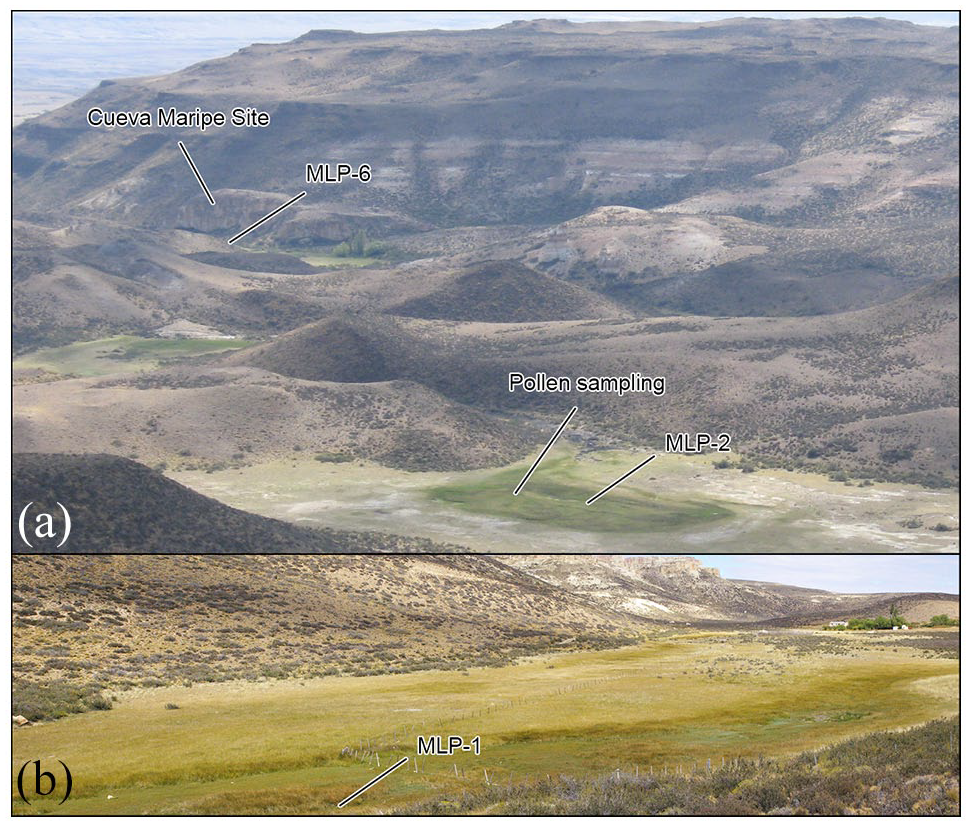
(a) View of Mallín La Primavera, plateau and slopes with vegetation of Patagonian steppe. (b) Headwaters of La Primavera wet-meadow.
In sum, in the area landscapes heterogeneity is registered while the climatic variability is low (de Porras, 2010). However, in the ravines (cañadones), protected from the wind, temperature is higher, (de Porras et al., 2009) mainly during summer which is the dry season.
Present day vegetation
Spatial variation in water availability on the central plateau (in addition to the topography, slope orientation and edaphic diversity) is one of the causes of the vegetation patchiness. The vegetation differences between the plateau and ravines are evident because both environments differ in the effects of wind and, therefore, in temperature and moisture.
These factors determine the structure and functioning of the ecosystem and the morphophysiological characteristics of its species (Bucci et al., 2011). According to the floristic physiognomic domains defined by the predominant life forms, shrub and dwarf-shrub steppes predominate in the study area (Baetti, 2004) (Figures 1 and 2).
The shrub steppe of the NE of the Deseado Massif is distributed in flat areas, on low slopes and ravines represented by tall shrubs such as Schinus marchandii, Berberis heterophylla, Mulinum spinosum, Senecio filaginoides, Lycium ameghinoi, L. chilense, Prosopis denudans, Colliguaja integerrima and Mulguraea tridens. Toward the south of the Massif the most represented shrub is M. tridens accompanied by tussock grasses and low shrubs (Nassauvia, Ephedra, Azorella). On high plateau (over 700 masl) a high grass steppe adjacent to or in mosaic with shrub or dwarf shrub steppe is present (Mancini et al., 2012).
The dwarf-shrub steppe, the most widely distributed vegetation unit in southernmost South America, is dominated by dwarf shrubs such as Nassauvia glomerulosa, N. ulicina, and Ephedra frustillata, cushion plants (Azorella monantha, Acantholippia seriphioides), bunch grasses (Pappostipa speciosa, P. humilis, P. chrysophylla, P. ibarii) and patches of shrubs (M. tridens, B. heterophylla, N. bryoides). At a regional scale, the dwarf-shrub steppe is generally considered a homogeneous unit although it is quite heterogeneous at the meso and local scales and presents important differences in composition as a consequence of the complex geomorphologic features of the Patagonian plateau (Roig, 1998). Furthermore, edaphic communities related to local conditions such as topography, slope orientation or soil characteristics are really common. The mallines are edaphic communities whose lands are seasonally or permanently flooded (Collantes and Faggi, 1999). These ecosystems are wet grasslands of high density and floristic richness, associated with the presence of water near the surface. They develop under variable physiographic conditions (topography, hydrology, soils, and vegetation) (Mazzoni and Vázquez, 2004) that differentiate them from the surrounding areas (Raffaele, 1999). The mallines can be classified according to different characteristics, such as their topographic location or their floristic structure (Mazzoni, 1987; Mazzoni and Vázquez, 2004) (Table 1). The classification based on vegetation includes an approximation to the hydrological dynamics of these geoforms because the association of represented species is directly related to the water availability. Thus, some species that appear in the pollen record can be used as humidity-aridity indicators at different times.
Floristic characteristics of the mallines according to the humidity degree (modified from Mazzoni and Vázquez, 2004).
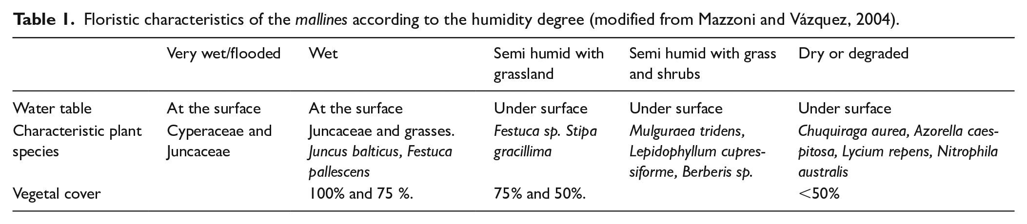
Three vegetation types are usually distinguished in a mallín related to their microtopography (Gandullo and Faggi, 2005) and a gradient of increasing moisture. In the central zone, which is flooded for much of the year, vegetation with hydrophytic species predominates. In the intermediate zone, where the water table is below the surface (between 50 and 150 cm), grasses predominate. The third vegetation type is the area where the water table usually fluctuates between 1 and 3 m depth, with Pappostipa and Festuca spp. (coirones) and dwarf-shrubs or shrubs. Given their faunal and plant resources, these environments have been used by hunter-gatherers.
Previous paleoenvironmental research
Pollen records from caves and rock shelters archeological sites of Deseado Massif provided paleoenvironmental information for the Holocene and, in some cases, since the Pleistocene – Holocene transition: Los Toldos (de Porras, 2010; Paez et al., 1999), Piedra Museo (Borromei, 2003), La Gruta (Brook et al., 2015; Mancini et al., 2013), La Martita (Mancini, 1998) and La Maria (de Porras, 2010; de Porras et al., 2009).
These pollen records have allowed the reconstruction of a similar vegetation history and a physiognomic change from a dwarf-shrub steppe to a shrub-grass steppe in the early Holocene. During the early Holocene a progressive temperature increase and relatively humid conditions were inferred related to a westerlies weakening and localization to the south of the area (Echeverría et al., 2017).
During the mid-Holocene a trend of temperature increase is suggested by a shift to shrub steppes (de Porras, 2010; Mancini, 1998). Sites from the Eastern Patagonia, showing synchronous changes mainly related to a water balance decline, would be responding to stronger westerlies that generate a steep precipitation gradient (Mancini et al., 2005, 2008).
Excavations in three lagoons from La Gruta area (see Figure 1) reached a gravel deposit suggesting that prior to sediment deposition, which began around 6500 cal yr BP, there was a period of dry and windy conditions with deflation of fine sediments from the lagoon basins (Brook et al., 2013, 2015).
During the late-Holocene the vegetation and climate conditions on sites located in the Patagonian plateau, similar to the modern ones, were established. These sites suggest similar water availability and plant communities composition (Brook et al., 2015; de Porras, 2010; Mancini, 1998; Mancini et al., 2013; Paez et al., 1999). A weakening of the SWW characterized the period between 4000 and 2000 cal yr BP (Schäbitz et al., 2013); the weakest west–east paleohydric gradient occurred between 2500 and 1200 cal yr BP (Echeverría et al., 2017). A drier environment began to establish toward 1000 cal yr BP and later a century scale fluctuation was recorded.
Chronological background
The human occupations chronology of Deseado Massif was presented in a previous paper using all the published radiocarbon dates from archeological sites (rockshelters, open air sites, and burials) (Mosquera, 2018). Compilation of radiocarbon ages and their summed age probabilities show three chronological discontinuities during the last 15,687 calibrated years. The first discontinuity covers the span 15,079–13,696 cal yr BP; the second one between 7828 and 6434 cal yr BP and the last one between 3005 and 2710 cal yr BP (Figure 3). The earlier discontinuity was not considered as a real hiatus since its initial date is isolated (AA-20125–12,890 ± 90 yr BP) (Figure 3) and was classified as an unexplained outlier (Steele and Politis, 2009).
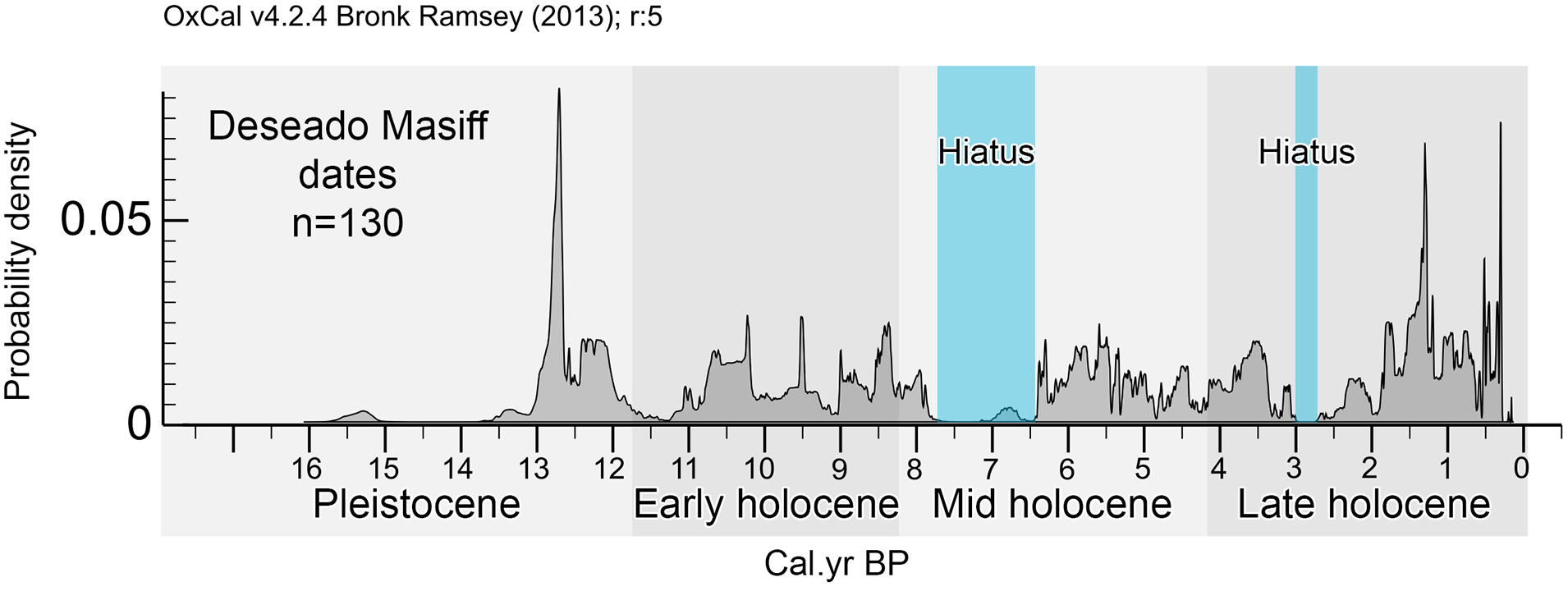
Sum of probabilities of radiocarbon dates from Deseado Massif archeological sites (taken from Mosquera 2018).
Thus, the studied region presents two chronological hiatuses: between 7828 and 6434 cal yr BP and between 3005 and 2710 cal yr BP. Within mid-Holocene hiatus an isolated date that does not overlap with previous or later dates and which was found in Rio Pinturas Area in the Deseado massif northwest margin can be observed (Figure 1).
Material and methods
Sedimentological analysis
In order to describe the MLP stratigraphy and to complement the pollen analysis, we took three sample cores (MLP-1, MLP-2, and MLP-6) from intermediate sectors of the wet-meadow. Samples were taken every 20 cm with a hand earth auger and color was classified by Munsell Color Soil Chart. Samples received a preliminary treatment by eliminating organic matter and carbonates with a solution of 30% H2O2 and 35% HCl. A solution of 2N Na4P2O7 and mechanical shaking were used for their dispersion. For the grain size analysis of coarse fractions (gravel and sand), sieving at intervals of one degree of phi was employed, and for the fine ones (silt and clay) the pipette method was used (Carver, 1971; Day, 1965). The percentages of sand, mud, and clay content were utilized for grain size classification according to Folk (1954). Also, in MLP-1 and MLP-6 organic matter and carbonate content were calculated through loss on ignition technique (LOI) (Heiri et al., 2001; Schulte and Hopkins, 1996).
With the aim of linking sedimentary characteristics and establish chronological relations with the pollen core and Cueva Maripe record, a 14C date was obtained from the bottom of MLP-6 sedimentary core, located near Cueva Maripe site.
Chronological data
Six levels of the pollen core and one from the sedimentological samples were selected for radiocarbon age determination. Radiocarbon ages were calibrated using the program OxCal 4.2 (Bronk Ramsey, 2009) and the SHCal 2013 calibration curve (Hogg et al., 2013).
The ages are expressed in calendar years before present at a two-sigma confidence level (95.45%).
An age-depth model of the Bayesian type was developed using the “Bacon” package of the R program (Blaauw and Christen, 2011). A smoothing spline model was used with a smoothing factor of 0.1.
Pollen analysis
Surface pollen samples that represent the current vegetation conditions of the mallín and the adjacent slopes were collected. Other samples were selected from the Paleoecology and Palynology Lab database (UNMdP-IIMyC, CONICET) which represent the vegetation of the plateau and ravines of the Deseado Massif (Figure 1b).
With a Russian-type sampler, a 225 cm core was obtained in the central (active) sector of the mallín. The subsampling was performed in the laboratory every 4 cm.
Modern and fossil sediment samples were processed with standard techniques for the extraction of pollen content (Bennett and Willis, 2001; Faegri and Iversen, 1989). The weight of the surface sediment samples varied between 10 and 20 g. Fossil sample weights varied between 0.5 and 2.6 g throughout the sequence with the exception of samples between 202 and 210 cm that weighed between 5 and 7.2 g. They were filtered through a 120 mm mesh and treated with KOH 10%, HCl, flotation in Cl2Zn δ = 2.2 g/ml), HF and acetolysis. Three tablets (
Percentages (%) of the main taxa were calculated from pollen sums of at least 300 grains. Pollen of Cyperaceae and spores (Pteridophyta and Glomus) were calculated separately and related to the sum of land plants pollen. Although Poaceae is an important component of the mallín vegetation (on a local scale) it was not eliminated from the sum since this family is also present on slopes and on the plateau (on a mesoscale and regional scale). Although the genera are different in communities with higher or lower humidity, the pollen morphology of this family does not allow differentiating them.
Percentages and concentration pollen diagrams were made with the TILIA program (Grimm, 2004). Pollen of Other herbs includes taxa with low representation (<2%) and discontinuous presence: Lamiaceae, Rubiaceae, Portulacaceae, Valeriana, Iridaceae, Polygala, Scrophulariaceae, Primulaceae, Plumbaginaceae, Ranunculaceae, and Polemoniaceae. The nomenclature is based on the “Catálogo de las Plantas Vasculares del Conosur” (www.darwin.edu.ar).
Pollen zones were performed with Cluster analysis using percentage data and Constrain Incremental Sum of squares (CONISS, Tilia 2.0.4, Grimm, 2004).
Results
Sedimentological analysis
The three sedimentological cores are between 200 and 280 cm long. In all of them the base of the sedimentary sequence was reached. Most samples are classified as sandy clay and sandy mud with a few exceptions of clay and mud (Figure 4b). Two main sections were recognized with different colors: a greenish one on the base, and a black one above, and mottling in the color transition section. The granulometric mean values are similar along the three analyzed cores: all samples show a mean for clay and fine silt sizes meanwhile samples that show a higher percentage of sand are those from the base or the top of sequence (Figure 4b). The organic matter content analysis of MLP-1 and MLP-6 shows similar percentages in the base levels, between 4% and 6% below the 80–100 cm level. From that level to the top the OM% increases to 12.6% and 13.6% (Figure 4a). The lower section of the cores with relatively low OM% values coincides with the water table fluctuation influence. No erosive surfaces or tephra layers were registered.
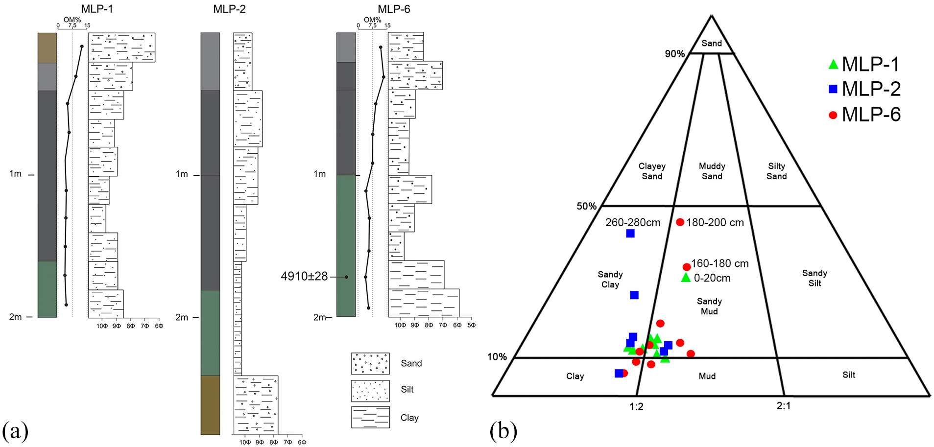
(a) Sedimentological arrangement and (b) granulometric classification (Folk, 1954) of Mallín La Primavera.
Radiocarbon dating and age–depth model
The age-depth model was made with five radiocarbon dates. One of them was discarded (14C 7543 ± 34 yr BP at 158 cm) because it was inconsistent in relation to the other dates (Table 2).
Radiocarbon dates of pollen core and sedimentological sample.

Calibrated using CALIBomb sofware (Reimer and Reimer, 2004) a post bomb data set (Hua et al., 2013) we adjust the date to 1957–1958.
An increase of organic sediment of plant fibers was observed in the upper 50 cm, ca. 150 yr cal BP (Figure 5).
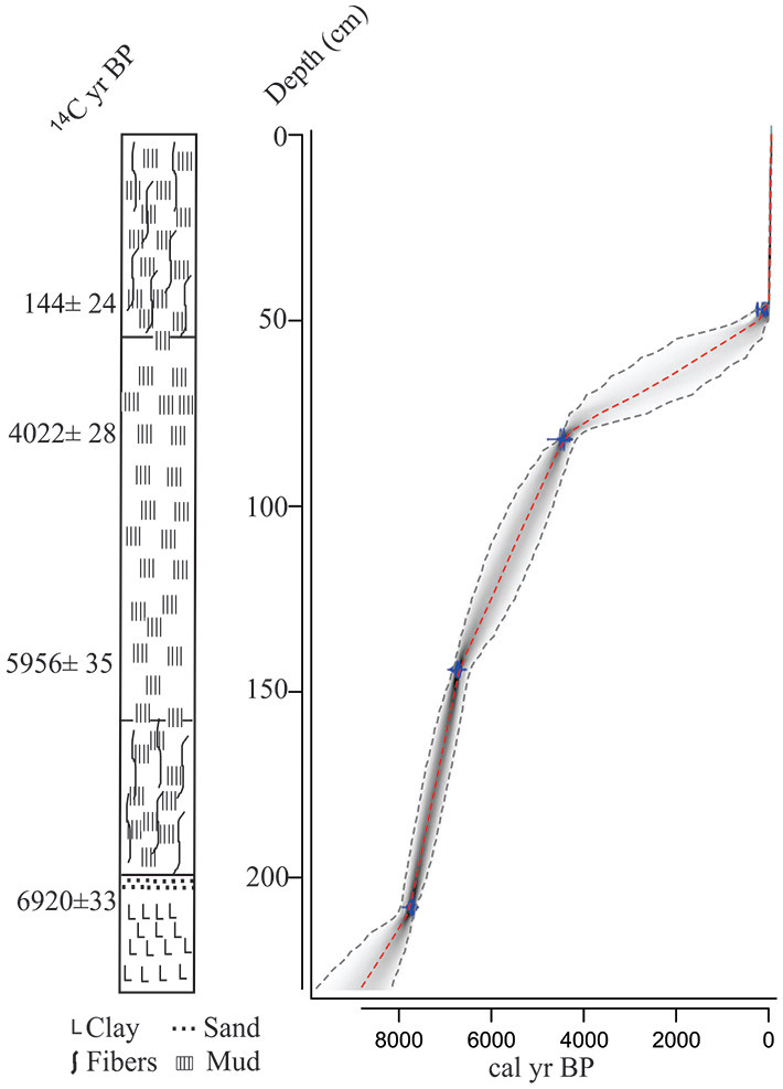
Stratigraphy, and age-depth curve of the core La Primavera mallin based on radiocarbon dates.
Pollen analysis
The modern pollen assemblages reflect the vegetation that grows in different topographic situation of the Deseado Massif (Figure 6) and represent the dominant vegetation on a regional scale. The shrub-steppe is characterized by dominance of different shrubs that predominates on areas, generally covered by a basaltic mantle. To the north (samples 1–8), the shrub steppe is represented by Asteraceae subf. Asteroideae (20%) Colliguaja (30%), Solanaceae (Lycium, up to 40%), and Verbenaceae (Mulguraea tridens, up to 40% in one sample) and Schinus (<5%) accompanied by dwarf shrubs such as Nassauvia (30%–40%) and grasses (Poaceae, 50%). To the south (samples 9–12) the steppe is represented mainly by Asteraceae subf. Asteroideae (30%) and Poaceae (30%) with Nassauvia (10%), Azorella (10%), and Ephedra (up to 40% in one sample).
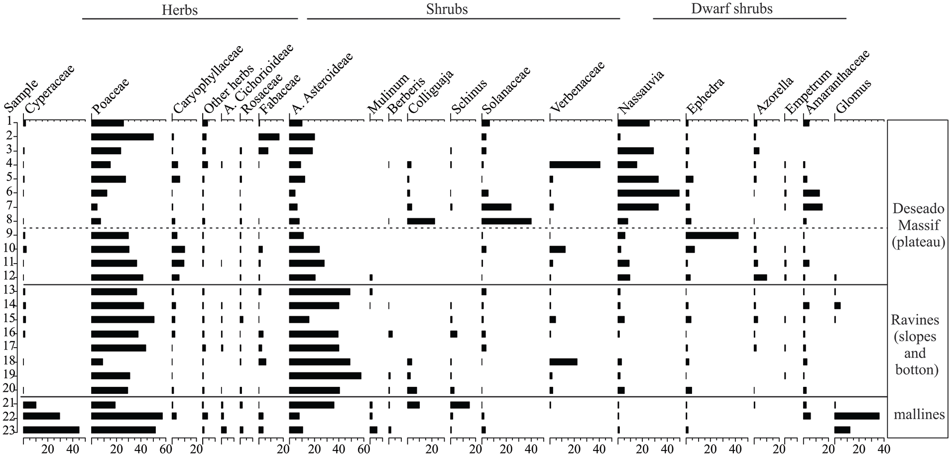
Surface samples of the Deseado Massif showing pollen assemblages in percentages.
Pollen records from samples located in ravines (Los Toldos, La María, La Martita, samples 13–20) suggest the presence of shrub steppes with Colliguaja (10%), Asteraceae subf. Asteroideae (up to 60%), Verbenaceae (up to 20%), Berberis, Schinus, Solanaceae (Lycium, <10%). Dwarf shrubs (Nassauvia, Ephedra, Azorella) are present with low values (<10%) and grasses reach 50%.
Mallín La Primavera surface samples (21–23) present the higher values in Poaceae and Cyperaceae (50%); in the drier sectors these taxa decrease and increase shrubs (Asteraceae subf. Asteroideae, Colliguaja, Schinus). Glomus present up to 40%.
In the pollen sequence of the mallín three pollen zones were obtained with Cluster Analysis (Figure 7): Zone 1. Before ca. 7700 cal yr BP (225-205 cm depth) Poaceae (40 -70 %), Asteraceae subf. Asteroideae (up to 15 %); dwarf- shrub steppe taxa such as Ephedra, Nassauvia and Azorella, (with percentages below 20 %) and Cyperaceae (20 - 55%) are present. Zone 2. It presents two subzones: Subzone 2.1, between ca. 7700 and ca. 6800 cal yr BP (202 and 145 cm depth). Poaceae reach values up to 80 %, Asteraceae subf. Asteroideae is present with percentages between 10 and 20 %, dwarf shrub taxa, Amaranthaceae (subf. Chenopodioideae) and Cyperaceae decrease (between < 5 and 20 %). Glomus with values up to 55 % is present in the most of the samples. Subzone 2.2. Between ca. 6800 and 4400 cal yr BP (140 and 75 cm depth). Poaceae decrease (between 20 and 55 %) and other herbs increase up to 20 %. Asteraceae subf. Asteroideae shows an increasing trend (up to 25 %). Other taxa of shrubs and dwarf shrubs increase; Schinus, Solanaceae, Lycium, <10%); Mulinum (10%) and Ephedra 20%) increase towards the top of the zone. Glomus decrease (between 10 and 30%) and Cyperaceae present the lowest values of the sequence (< 5 %). Zone 3. At the base (Subzone 3.1, 65-70 cm), Mulinum, Ephedra and Amaranthaceae subf. Chenopodioideae increase (up to 20 %). Poaceae, herbs and Cyperaceae decrease. In the subzone 3.2 (ca. 260 cal yr BP, 60-20 cm) Poaceae present variable values between 30 and 70 %, accompanied by Caryophyllaceae and other herbs. The shrub stratum is represented by Mulinum up to 40 %), Asteraceae subf. Asteroideae (up to 20%), Berberis, Colliguaja, Schinus, Solanaceae and Lycium (5 %), Glomus and Cyperaceae increase to the top (up to 50 % and 20 %, respectively).
The upper samples (Subzone 3.3, 0–20 cm) represent the last decades. Poaceae (10%–50%), Asteraceae subf. Asteroideae (10 up to 25%) and Mulinum (15%–50%) are present accompanied by other shrubs and dwarf shrubs. Glomus and Cyperaceae increase at 5 cm (40% and 20%, respectively).

(a) Diagram of pollen percentages and pollen zones for Mallín La Primavera. (b) Pollen concentration of the main pollen taxa and total concentration of Mallín La Primavera.
The pollen concentration (Figure 7b) shows similar general patterns, characterized by high values of Poaceae and Cyperaceae at the base of the sequence followed by their lowest values and increase of Cyperaceae toward the present. The shrubs and dwarf shrubs increase after ca. 5000 cal yr BP and present the highest values to the top of the sequence.
Discussion
On the basis of radiocarbon dates, the Mallín La Primavera sequence shows that mallín was already present in the early mid- Holocene.
The sedimentological analysis of cores from intermediate sectors of Mallín La Primavera (MLP-1, MLP-2 y MLP-6) presents clear similarities within the basin (Figure 4). The main textures are sandy clay and sandy mud. Color and sediment mottling presence has been a characteristic feature of the three cores, with a greenish deposit in the base overlain by black mud showing a typical hydromorphic evolution. These features allow us to infer that the water table oscillates mainly bellow 1 m depth as expected in intermediate sectors. In the case of MLP-2 we recognize a gleyzation process in the core base. The grain size means and the granulometric distributions correspond to low energy sedimentation environment with flood events and very low energy streams.
Although the description of the sediments in the pollen analysis core was made with the naked eye, the main textures from the base to the top coincide with the descriptions of the sedimentological cores.
The pollen record interpretation is based on comparison with present-day pollen assemblages from different plant communities of the central plateau and from slopes and ravines (Figure 6, Mancini et al., 2012) where topographic features and hydrological regime are a secondary gradient that operates on a local scale (Gaitán et al., 2011).
The base of the sequence (prior to 6900 yr BP, 7700 cal yr BP), with a predominance of clay, is characterized by high values of Cyperaceae (percentage and concentration) coincident with a very wet/flooded mallín type (Table 1) suggesting conditions wetter than present. This section represents the central zone of the mallín, flooded most of the year with predominantly hydrophytic vegetation. The diatoms analysis carried out in Cueva Maripe site suggested that the site had flood periods previous to the human occupation dated in 9500 14C yr BP related to more humid conditions than the present characteristics of the early Holocene (Fernández, 2013), which would have extended up to 7700 cal yr BP. This environment, in this particular case with numerous active subsidiary springs, would have served as the most critical attractor of vital resources: the availability of water (Magnin, 2010; Miotti et al., 2007). In a semi-arid region, this would have favored the establishment of camps and also the capture (hunting) of fauna. Furthermore, Poaceae is mainly related to the genera that grow in the mallín so that the grasses would also have been an attraction for herbivores. Poaceae associated with the dwarf shrubs represented by Nassauvia, Ephedra, Azorella, and Empetrum is also found in the vegetation growing on the slopes and on the plateau. These pollen assemblages are present in pollen records of Los Toldos and La María (de Porras, 2010) suggesting the composition of the regional vegetation of the plateau.After ca. 7700 cal yr BP a black mud predominates along the core. The pollen record indicates a change in the vegetation that grows mainly in the mallín surface with a Cyperaceae decrease and a Poaceae increase. This change suggests a lower water table in the mallín. There were also high percentages of Glomus, a genus of fungus that forms arbuscular mycorrhizae (MA) considered a good indicator of aridity conditions. The vegetation of arid and semi-arid ecosystems supports long periods of drought and evaporation. In these situations, MA allows plants to resist these adverse conditions by increasing tolerance to drought and nutrient absorption (Montaño et al., 2007). Glomus is mainly associated with grasses, and its presence may indicate that the higher proportion of Poaceae pollen represents the local vegetation, suggesting semi-humid conditions of the mallín.
Between ca. 6800 cal yr BP and ca. 4400 cal yr BP (6000 yr BP–4000 yr BP) Cyperaceae and Poaceae were present with low values in percentages and concentration, and the increase of shrubs is recorded. Among them Adesmia (Fabaceae), Lycium (Solanaceae), Senecio (Asteraceae), and Schinus there are some of the shrubs that currently grow on the low slopes, around the mallín. At ca. 4400 cal yr BP (4000 yr BP) dwarf-shrubs, mainly Ephedra, representative of regional vegetation growing on high slopes and on the plateau also increased and the herbaceous pollen types are represented with very low values. The reconstructed vegetation suggests drier conditions probably related to the temperature increase in the area. These communities with medium and high shrubs (Asteraceae subf. Asteroideae, Berberis, Schinus, and Lycium) and dwarf and cushion shrubs (Nassauvia and Ephedra frustillata) are currently found in the northeast of the Deseado Massif with higher temperatures than in the southern sector (Mancini et al., 2012). The rates of direct evaporation from the soil surface can be high in spring and summer with more hours of daylight, high radiation, strong winds, and low relative humidity. In the north of Santa Cruz, daily potential evapotranspiration values in January reach 6.5 mm. This loss of water availability is increased by the typical scattered rainfall regime and by the high proportion of bare soil, especially in the drier or degraded areas (Oliva et al., 2001). When the surface of the wetland is drying, the decomposition of plant material increases. The samples corresponding to this period show greater decomposition of organic matter, without fibers or plant macro remains.
The late-Holocene records indicate variability between wet and dry periods. After 4400 cal yr BP (4000 years BP) increase in Mulinum and Ephedra indicates shrubland expansion around the mallín. The dry conditions of the mallín are also indicated by the low values of Cyperaceae and Poaceae; Amaranthaceae (subf. Chenopodioideae) is an indicator of increased evaporation process (Zone 3.1). The sedimentation rate is lower than in the lower sections Among the taxa indicators of deterioration of mallines are Acaena magellanica, Azorella trifurcata, Mulinum spinosum and Lycium repens. These taxa and other indicator taxa of disturbance are found in the pollen record including Azorella, Mulinum, Rosaceae, and Solanaceae, with higher values in the upper section, especially for Mulinum (zone 3.2).
In the upper 40 cm, the core shows a significant increase in the sedimentation rate. According to Loisel and Yu (2013), high peat accumulation rates can be explained by high plant growth and peat production on the surface and low decay, as indicated by the presence of fibers and other plant macro remains in these upper samples. The weak temperature seasonality combined with higher moisture optimizes peat accumulation. The increase in the values of Cyperaceae during this period may be indicating higher water levels in the mallín.
In the uppermost 20 cm there is a significant increase in shrub taxa percentages and concentration (Figure 7). The highest values of Mulinum can be related to grazing since they coincide with the farm establishment in historical times and the presence of sheep grazing in the mallín. At the end of the 19th century sheep were introduced to Santa Cruz province and reached the highest number in the 1940s and 1950s. But it is difficult separate climate induced vegetation change from human impact given the geomorphologic complexity of the area.
Comparison with other records (regional scale)
The results of pollen sequences coming from lagoon deposits, dry lagoons and archeological sites located along the west-east gradient in the latitudinal strip that comprises the study area (between 46° and 49° S) are summarized (Figure 8). Although the sequences of archeological sites present stratigraphic discontinuities, the palynological information is similar in all of them and comparable with the pollen information obtained from the MLP, which is a natural deposit without cultural evidence.
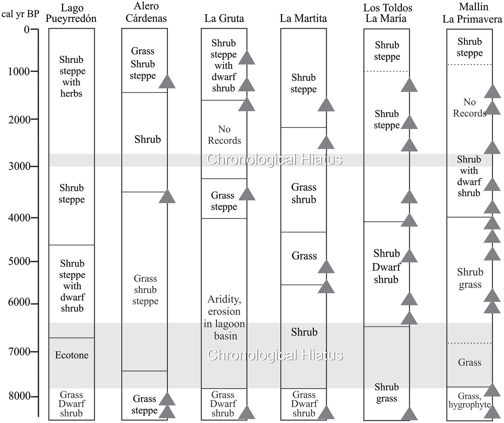
West-East plant physiognomies reconstructed by pollen analysis in the Deseado Massif at 47°S (Brook et al., 2015; de Porras, 2010; Horta et al., 2016, 2019; Mancini, 2002). Evidence of human occupation is indicated at each locality with a triangle.
The sequences of archeological sites have provided important information about changes in vegetation and climate at different spatial and temporal scales. However, these sequences can represent, in certain cases, time windows of the vegetation history so that the palynological information obtained from other sedimentary deposits (such as the MLP sequence) could complement these temporal hiatuses (Marcos et al., 2020).
These pollen assemblages allowed reconstructing the plant communities from west to east comparable to the current ones in the Patagonian plateau. These pollen records indicate an increase in shrub and dwarf shrub vegetation in response to conditions of increasing semiarid climate during mid-Holocene.
During the early Holocene (around 8500 cal yr BP), the vegetation was represented by grass steppe associated with dwarf-shrubs in La Martita, La Gruta, Alero Cárdenas and Lago Puyerredón area, suggesting conditions of higher humidity than at present.
Between 8000 and 6000 cal yr BP in the Deseado Massif a shrub-steppe dominated by Asteraceae subf. Asteroideae would relate to a decrease in water availability. On a regional scale, the pollen records of the Deseado Massif indicate that the main vegetation changes since the early Holocene responded to the interaction of different factors, such as gradual increase in temperature and intensity and frequency of winds that may have affected water availability (Brook et al., 2015; de Porras, 2010). The sediment analysis of the lagoon at the La Gruta site, at the south of Deseado Massif, indicates that prior to 6500 cal yr BP there was a dry and windy period. For that period there are no sediments in the stratigraphic sequence of La Gruta cave (Brook et al., 2015).
To the west a vegetation change is associated with a greater heterogeneity in the Lago Pueyrredón area where a shrub steppe-forest ecotone developed (Bamonte et al., 2013; Horta et al., 2019). These changes are related to an intensification of westerly winds with higher precipitation in the Andean zone and drier conditions over extra-Andean zone leading to higher evaporation (Bamonte et al., 2013; Mancini et al., 2005; Marcos et al., 2020; Sottile et al., 2012).
The mid-Holocene is reflected in the La Martita record by a short-term environmental change. About 4500 cal yr BP this steppe changed to a grass shrub steppe. During this period in Alero Cárdenas a similar grass-shrub steppe developed (Mancini, 1998).
During the late-Holocene in Lago Pueyrredón area and Los Toldos-La María, the last millennial is characterized by an increase in shrubs, whereas in sites of Alero Cárdenas, La Martita, and La Gruta shrubs are accompanied by grass and dwarf shrubs (Brook et al., 2015; de Porras 2010; Horta et al., 2017; 2019; Mancini, 2002).
The paleoclimatic inferences indicate that the most important changes are in water availability related to intensity of westerly winds and temperature, probably in terms of seasonality; the precipitation varied within modern range (Mancini et al., 2002).
The pollen analysis of the sequences of the Deseado Massif ravines indicates similar changes in the plant communities during the Holocene, suggesting similarity in the paleo-environmental conditions. Although the pollen assemblages from each of these sites represent local vegetation, their comparison suggests that they would have responded to changes on a regional scale. According to the current pollen analysis, the composition and distribution of the shrub and dwarf shrub communities of the massif (regional scale) and the ravines (local scale) are given as a function of the northeast-southwest temperature gradient, the west-east precipitation gradient and the topography.
Another type of evidence to reconstruct climatic changes during the Holocene is given by lake levels which are very sensitive to changes in the evaporation/precipitation ratio, increasing rapidly during periods of rainfall while decreasing during drought intervals. These changes in lake levels imply changes in the landscape and in plant communities and, therefore, in the supply of new spaces and resources for human populations.
In the south of Patagonia, changes in levels of different lakes since the late Pleistocene have been studied, which indicate the existence of paleolakes of greater extension than in the present. Toward the west the sedimentological surveys have determined the connection of Salitroso, Posadas, and Pueyrredón lakes until ca. 5900 cal yr BP (Horta et al., 2019) when the current lake configuration was established.
Seismic and sediment studies of Lake Cardiel (Gilli, 2003; Gilli et al., 2001, Markgraf et al., 2003; Stine and Stine, 1990) indicate a very humid period during early Holocene; since 6800 cal yr BP an increase in magnetic susceptibility documents an intensification of the westerly stormtracks (Gilli et al., 2005). This intensification in the winds would explain the decrease in humidity in the plateau east of the Andes that is expressed in Lake Cardiel with one of the lowest levels toward the 6800 cal yr BP (Ariztegui et al., 2014).
In the semiarid region of the Patagonian plateau, at the North of the study site, changes have also been observed in the levels of the Colhué Huapi and Muster lakes. The decline in the paleolake level would have occurred from mid-Holocene regional arid climatic conditions (Gilli et al., 2005; Markgraf et al., 2003; Moreno et al., 2009).
These changes coincide with the vegetation reconstruction and the moisture availability inferences from the pollen analysis of the sequences considered in this work.
Environmental changes and human occupations
The Deseado Massif pollen records show a trend to warmer and drier conditions since 8000 cal yr BP, reaching the maximum at 6800 cal yr BP (Markgraf et al., 2003). This general trend correlates with the information from MLP and the onset of the chronological hiatus (ca. 7800–6400 yr cal BP). Archeological records of the area show highly mobile human groups covering wide distances from the Pleistocene/Holocene transition to late-Holocene. The record of Andean obsidian and Atlantic coast shell species in archeological sites of the region confirm this aspect (Franco et al., 2015; Hermo and Lynch, 2017; Miotti, 2008; Pallo and Borrero, 2015). Furthermore, several rockshelter archeological sites present re-occupation evidences during the Holocene (pre and post hiatus) (see Mosquera, 2018 and references). Peopling models for Patagonia consider that during mid-Holocene the population was higher than during previous times (i.e. higher sites frequency) (Miotti and Salemme, 2004); Borrero (1994–95) also postulated that since 6000 14C BP (6900–6700 cal BP) some regions in Patagonia showed stable occupation.
In Patagonian archeological records, guanaco (Lama guanicoe) is the main faunal resource from Pleistocene to historic times. Zooarcheological studies in Cueva Maripe site and AEP-1 show a trend in guanaco exploitation during mid-Holocene to a greater work investment to obtain more nutrients from resources traditionally used (Marchionni et al., 2019). This change is inferred by an increase in cut marks frequency, high intentional fracture frequency of long bones and the use of bone as raw material for instruments (García Añino, 2018; Marchionni et al., 2019).
In the context of drier conditions as those recognized in MLP pollen record and the beginning of an environmental stress situation, the change in guanaco use strategy could be a social response to this new reality. Furthermore, if mobility and spatial organization was the main social mechanisms that highly mobile hunter-gatherers use to deal with environmental changes, the presence of the chronological hiatus could be an evidence of abandonment or spatial rearrangements.
The presence of chronological hiatuses during mid-Holocene was registered in several regions of the South America, and especially in arid regions (Méndez et al., 2015; Neme and Gil, 2009; Núñez and Santoro, 1988; among others). Barberena et al. (2017) proposed that persistent arid conditions produced a landscape fragmentation and a consequent concentration of human groups in suitable refuges. The authors postulate that this situation generates a demographic bottleneck for this lapse, where social and spatial rearrangements and population retraction in a macro-scale took place. The Deseado Massif case could be part of this process, but needs an integration of information and the generation of new archeological data (i.e. open air sites, new wet-meadows analysis) to confirm if the macro-scale process proposed by Barberena et al. applies to this region.
Conclusion
The vegetation changes inferred from pollen records from MLP cannot be related to climate variations only. However, its comparison with others paleoenvironmental and archeological records from the Deseado Massif show a similar pattern of changes and can be linked to the response of the vegetation of these sites to changes in climatic variables.
Although these changes may have influenced the entire sequence, probably in the upper part with greater deposition of sediment, and dominance of shrubby vegetation, the main influence has been the farm establishment and sheep introduction.
The hydrological dynamic of MLP is the result of direct precipitation on the wet-meadow, the contribution of the water table, as well as surface run-off from the surrounding slopes.
Although the MLP provides mainly local information, when it is compared with other paleoenvironmental (paleoclimate) records from the arid semiarid region it is possible to reconstruct a regional scenario.
There is a correlation between the beginning of dry conditions in MLP and Deseado Massif, and the regional absence of archeological radiocarbon dates at ca. 8000 yr cal BP. Our data endorse the hypothesis of a regional water decrease as the reason of archeological chronological hiatus by regional abandonment or, maybe, spatial rearrangements.
Additional data from mallines are needed to confirm regional Holocene landscape changes and, on the other hand, qeoarchaeological surveys must increase the search of datable open air sites to evaluate the hunter-gatherers strategies in view of changing past climates.
Footnotes
Acknowledgements
We thank the reviewers, V. Markgraf and an anonymous reviewer, whose comments helped in improving the manuscript. We are grateful to Mr. Koprowski owner of Estancia La Primavera for allowing us work in his property, and Ramón Cano for the hospitality. Maria Alejandra Marcos, Florencia Bamonte, Marcos Echeverria y Gonzalo Sottile for the collaboration in the field work.
Funding
The author(s) disclosed receipt of the following financial support for the research, authorship, and/or publication of this article: Funding was provided by PICT-04599-2019, PICT 0763-2015, CONICET- PIP 414; UNMdP-EXA 941/19.
